Update to Lake Houston Area Grassroots Flood Prevention Initiative
|
|
|
- Lambert Cross
- 6 years ago
- Views:
Transcription


1 Update to Lake Houston Area Grassroots Flood Prevention Initiative Kaaren Cambio April 17, 2018


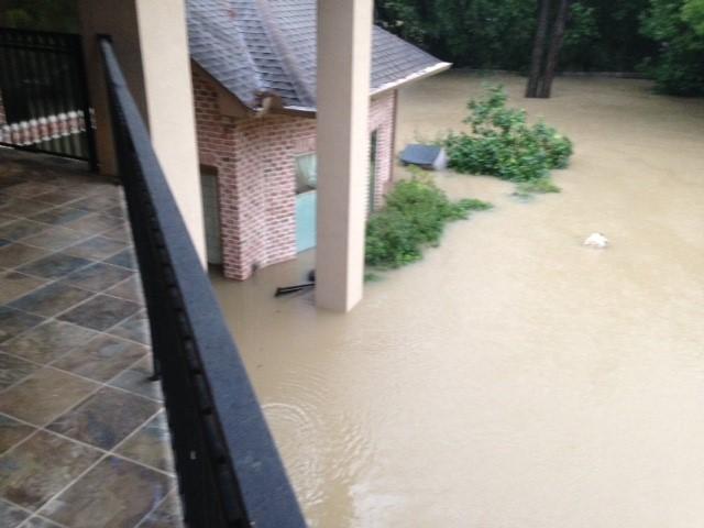
2 Where were you when Harvey came?
3 Harvey Average of 33 of rain in 4 days across Harris County. 120,000 structures damaged in Harris County alone. Source: HCFCD Website
4 October 1994: 3096 Homes damaged in Harris County Source: American Red Cross
5 April 18-20, 2016 As of 3 p.m. local time, Houston Intercontinental Airport had received inches of rain since midnight. If confirmed, this would make today the wettest day on record there, which was inches on June 26, Source: Mashable.com
 27.")
6 Estimated Peak Inflow Into Lake Conroe ,000 cfs Release from Lake Conroe Dam 79,141 cfs 21.1 Spring Creek Tomball, TX 48,800 cfs Lake Creek Sendera Ranch Rd 58,000 cfs San Jacinto River Authority USGS Stream Gage Direction of Flow Rainfall Totals (inches) 27.0 HWY ,000 cfs I ,000 cfs Spring Creek Spring, TX 82,100 cfs 18.5 Cypress Creek Westfield, TX 28,100 cfs Miles Caney Creek Near Splendora, TX West Fork San Jacinto Near Porter, TX 130,000 cfs Splendora, TX 31,300 cfs East Fork San Jacinto River New Caney, TX 119,000 cfs 27.4 Luce Bayou Lake Houston Estimated Peak Inflow 400,000 cfs (Based on Limited Available Information) May 26-30, 2016 At one point on Thursday, flash flood watches covered more than 183,000 square miles of Texas, an area about the size of Germany and England combined. More than 15 inches of rain fell just northeast of Houston in a span of 12 hours on Thursday, just a few days after more than 20 inches fell in two days northwest of the city the region s second 100-year rainstorm in less than a week. ÔÕ!( ÔÕ!(!( 20,900 cfs Peach Creek!(!(!(!( ÔÕ ÔÕ ÔÕ ÔÕ!( ±!( ÔÕ San Jacinto River Basin Estimated Peak Flows Hurricane Harvey August 25-30, 2017!( ÔÕ ÔÕ!( ÔÕ Source: Slates.com

7 Good Friday of rain can cause the river to crest. Dave Martin prereleased Lake Houston Source: ReadyHarris.org
8 Bottom Line: No TWO storms are Alike There are MANY uncontrollable water sources in the San Jacinto Watershed There are MULTIPLE agencies involved.

9 San Jacinto River Basin Watershed *Montgomery County * Harris County * City of Houston * Walker County * Liberty County * Waller County * Chambers County * Fort Bend County * Coastal Water Authority * 100 s of Mud Districts * Lake Houston Chamber of Commerce
10 Governor Abbott visits Kingwood on March 15, 2018: During the meeting the Governor announced a number of important and specific steps Texas will be taking to help prevent future flooding. These actions include: Using Hazard Mitigation Funds, the Texas Department of Emergency Management (TDEM) has authorized $3 million to jumpstart the engineering and permitting process to determine where dredging should on the San Jacinto River. Using Hazard Mitigation Funds, TDEM has authorized $2 million for a regional study focused on the San Jacinto River watershed to prevent future flooding. Using Hazard Mitigation Funds, FEMA has approved over 900 voluntary buyouts in Harris County. Instructing the Texas Commission on Environmental Quality to investigate and take action against sand mining operations violating regulations. Directing the San Jacinto River Authority (SJRA) to immediately identify what can be done to prevent flood events along the West Fork of the river. Directing the SJRA to implement immediate and long-term solutions to protect lives and property of Texans living in the watershed. Directing the SJRA to identify funding to implement a long-term plan that better protects areas downstream of Lake Conroe Source: Governor Abbott Press Release

11 SJRA Responds SJRA Announces an New Flood Management Intiative In response to the Governor s charge, the Board of Directors and leadership team of the SJRA have decided to create a new flood management division and begin implementing flood mitigation activities, a role that is outside the norm for river authorities in Texas SJRA Hires Chuck Gilman, P.E. as Director of Flood Management Chuck comes to the Authority from the City of College Station where he served as the Deputy City Manager and was recently elevated to the role of Interim City Manager. During his time at the City, he also served as the Assistant Director of Water Services, Director of Capital Projects, and Director of Public Works. Over the last ten-plus years, Chuck has held positions of responsibility covering every aspect of municipal administration, including utilities, transportation, drainage, emergency planning and response, planning and zoning, and legislative and governmental affairs. Prior to his time at the City of College Station, Chuck served in the private sector as an engineering consultant, overseeing the design and construction of a variety of civil engineering projects. Chuck is a licensed Professional Engineer in the State of Texas and holds a Project Management Professional Certification from the Project Management Institute. He earned a Bachelor of Science in Civil Engineering from Texas A&M University. Source: SJRA Press Releases
12 SJRA works on a watershed-wide Flood Study HCFCD/SJRA/Montgomery County/COH are working on a regional study for the upper San Jacinto basin. Leveraging $2 million in FEMA funds through Texas Division of Emergency Management. Looking at enhanced flood warning tools, sedimentation, and flood mitigation strategies. Table 1. Streams that will be Included in the San Jacinto Regional Watershed Study Stream Name Stream Length (Miles) West Fork San Jacinto River 61.4 East Fork San Jacinto River 73.2 San Jacinto River 16.3 Lake Creek 58.9 Cypress Creek 60.5 Little Cypress Creek 20.8 Spring Creek 69 Willow Creek 19.8 Caney Creek 49.3 Peach Creek 53.5 Luce Bayou 31.2 Tarkington Bayou 17.1 Jackson Bayou 4.6 Total 535.6
13 Talks to increase temporary Reservoir capacity: Why is lowering Lake Houston and Lake Conroe such a complex issue? Lake Houston can only release 10,000 cfs Lake Conroe is permitted for 1/3 SJRA and 2/3 City of Houston This is areas drinking water The rest of the State is experiencing a drought The temporary lowering of Lake Houston was met with negative feedback Current discussions between TCEQ, TWDB, COH and SJRA
14
 State Legislature Montgomery County Harris County City of Houston Lake Houston Area Chamber of")
15 Other agencies have also responded: Federal Government (FEMA, USACE) State of Texas (GLO) State Agencies (TCEQ) State Legislature Montgomery County Harris County City of Houston Lake Houston Area Chamber of Commerce
16 Post- Harvey Federal Assistance HUD CBDG Disaster Recovery Dollars: $5.024 billion block grant current open comment from texasrebuilds.org. Half of this money should go to Harris County. FEMA USACE Just completed 1D Study of SJR and should have preliminary plan at the end of the week. (Dredge SJR)
17 Post- Harvey State Assistance Respond to GLO Notice of Public Comment by mail/fax/ or online form. Here is a master site for GLO-CDR Action Plans and Amendments Deadline is 5:00 p.m. April 26 th TCEQ TWDB Governor Greg Abbott Senator Brandon Creighton Congressman Dan Huberty

18 Montgomery County: Partner in SJRA study Looking at putting detention ponds along Spring Creek, Caney Creek and Peach Creek ( all flow in to Lake Houston through the East Fork No designated flood funding like HCFCD.
19 Harris County: Managed initial debris pick up. Passed ordinance that required residents in homes and business located within the 100-year floodplain to be built two feet above the 500-year floodplain to mitigate flooding to structures (December 5, 2017) Drainage network assessment and repairs Partner with SJRA in watershed-wide flood study * HCFCD spearheading effort to regionalize and expand their flood warning system. Cell phone driven warning system planned Would include more gages and more predictive tools to increase notice time. Readyharris.com Add to Facebook and Twittter Talks about a Harris County Bond for Flood Projects (Date and Amount and designation TBD) Manages FEMA Home buyout program Harris County Appraisal District ( HISD form September and new valuation from January 1)

20 City of Houston: Studying Lake Houston Dam to increase release capacity. Chapter 19 passes City Council. Discussions with SJRA about seasonal lowering of Lake Houston and Lake Conroe. COH conducting targeted studies Steve Costello, Flood Czar Councilman Dave Martin, Kingwood
21 Lake Houston Area Chamber of Commerce * Federal disaster tax credits - HR3823 * Small business loans - 0% Interest - $25,000 with 4 month deferment - Goldman Sachs, Susan and Michael Dell Foundation, etc. * Small business grants - Lift Fund - $225,000 - Grants up to $5,000 each
22 Summary of projects under Consideration Dredge the San Jacinto River (one time and maintenance) Ensure aggregate processors are not continuing to add to the siltation problem in the SJR Increase seasonal capacity in Lake Houston and Lake Conroe until long-term projects take effect Increase the capacity of Lake Houston Dam Creation of additional reservoirs Additional building restrictions in adjacent counties Area-wide flood prevention program
Flood Event Analysis to Estimate the Avoided Damages Due to Flood Improvement Projects & Voluntary Buyout Program
 Flood Event Analysis to Estimate the Avoided Damages Due to Flood Improvement Projects & Voluntary Buyout Program Ataul Hannan, P.E., CFM Planning Division Director Harris County Flood Control District
Red River Levee Panel
 Red River Levee Panel Mississippi River Commission Monday, August 9, 2017 Red River Levees in LA & AR NONE along TX & OK Boarder Red River Levee Issues Caddo Levee Cherokee Park Authorization Bossier Levee
 Red River Flooding June 2015 Caddo and Bossier Parishes Presented by: Flood Technical Committee Where the Rain Falls Matters I-30 versus I-20 I-20 Backwater and Tributary Floods (Localized) 2016 Flood
Drought. Jeffrey Lindner Meteorologist Harris County Flood Control District September 20, 2011
 2010-2011 Drought Jeffrey Lindner Meteorologist Harris County Flood Control District September 20, 2011 Texas Annual Rainfall Texas Annual Rainfall 1895-2010 Texas Annual Temperature 1895-2010 Notice Any
Hurricane Harvey Flood Emergency Response
 Hot Science - Cool Talk # 114 Hurricane Harvey Flood Emergency Response Dr. David Maidment September 14, 2018 Produced by and for Hot Science - Cool Talks by the Environmental Science Institute. We request
Hurricane Harvey. Jeff Lindner. Meteorologist Harris County Flood Control District
 Hurricane Harvey Jeff Lindner Meteorologist Harris County Flood Control District Addicks and Barker Watersheds Hurricane Harvey Track A Category 4 Hurricane With Epic Flood Forecasts had to separate the
Dig it KingwooD. San Jacinto River and Lake Houston Kingwood, TX
 Dig it KingwooD San Jacinto River and Lake Houston Kingwood, TX 2017-2018 Devastating Effects of Harvey Flooding in Kingwood Kingwood Residents & Businesses Demand Solutions! May 24, 2017 I 69 Target &
NATIONAL WEATHER SERVICE
 January 2016 February 9, 2016 This was a dry month across the HSA despite one large and several smaller snowfalls. Most locations ended up 1-2 inches below normal for the month. The driest locations at
The hydrologic service area (HSA) for this office covers Central Kentucky and South Central Indiana.
 for this office covers Central Kentucky and South Central Indiana.") MONTH YEAR January 2011 February 15, 2011 X An X inside this box indicates that no flooding occurred within this hydrologic service area. January 2011 was drier than normal in all locations in the area.
MONTH YEAR January 2011 February 15, 2011 X An X inside this box indicates that no flooding occurred within this hydrologic service area. January 2011 was drier than normal in all locations in the area.
President s Day Weekend Storm Community Meeting and Workshop April 17, 2017
 President s Day Weekend Storm Community Meeting and Workshop April 17, 2017 Meeting outline 1. Progress update on the City of San Jose s recovery efforts 2. Water district presentation on: Weather situation
Pequabuck River Flooding Study and Flood Mitigation Plan The City of Bristol and Towns of Plainville and Plymouth, CT
 Pequabuck River Flooding Study and Flood Mitigation Plan The City of Bristol and Towns of Plainville and Plymouth, CT Raymond Rogozinski and Maged Aboelata The City of Bristol and Towns of Plainville and
USING GIS TO MODEL AND ANALYZE HISTORICAL FLOODING OF THE GUADALUPE RIVER NEAR NEW BRAUNFELS, TEXAS
 USING GIS TO MODEL AND ANALYZE HISTORICAL FLOODING OF THE GUADALUPE RIVER NEAR NEW BRAUNFELS, TEXAS ASHLEY EVANS While the state of Texas is well-known for flooding, the Guadalupe River Basin is one of
FEMA Hazards Loss Modeling Task Force (MOTF) Situation Report #14. Colorado Spring Flood Risk ***FINAL REPORT***
 Situation Report #14. Colorado Spring Flood Risk ***FINAL REPORT***") FEMA Hazards Loss Modeling Task Force (MOTF) Situation Report #14 Colorado Spring Flood Risk FEMA Modeling Task Force (MOTF) Denver Federal Center, Building 710A Denver, Colorado 80225 Email: FEMA-MOTF@fema.dhs.gov
FEMA Hazards Loss Modeling Task Force (MOTF) Situation Report #14 Colorado Spring Flood Risk FEMA Modeling Task Force (MOTF) Denver Federal Center, Building 710A Denver, Colorado 80225 Email: FEMA-MOTF@fema.dhs.gov
2014 Annual Mitigation Plan Review Meeting
 2014 Annual Mitigation Plan Review Meeting Highland County EMA MEETING OBJECTIVES Understand Your Natural Disaster Risk Review of Previous Plans Current Plan Status Future Activity Plan/Needs of Each Community
Doug Kluck NOAA Kansas City, MO National Center for Environmental Information (NCEI) National Integrated Drought Information System (NIDIS)
 National Integrated Drought Information System (NIDIS)") National Integrated Drought Information System (NIDIS) for the Missouri River Basin Drought Early Warning Information System (DEWS) & Runoff Trends in the Missouri Basin & Latest Flood Outlook Doug Kluck
National Integrated Drought Information System (NIDIS) for the Missouri River Basin Drought Early Warning Information System (DEWS) & Runoff Trends in the Missouri Basin & Latest Flood Outlook Doug Kluck
Hydrologic Briefing Tropical Storm Harvey
 Hydrologic Briefing Tropical Storm Harvey 10:30 AM CDT Sunday, August 27, 2017 Prepared by: John Metz NWSCorpus www.weather.gov/corpuschristi Situation Overview Tropical Storm Harvey Harvey to remain a
Suwannee Satilla Basins Flood Control Issues, Opportunities and Assistance
 Suwannee Satilla Basins Flood Control Issues, Opportunities and Assistance Georgia Silver Jackets Meeting Valdosta, GA April 11, 2013 Presentation Outline Basin overview Recent floods: 2009 100 year flood
Severe Weather Potential for Southeast Texas
 Severe Weather Potential for Southeast Texas Dan Reilly, Kent Prochazka, Scott Overpeck National Weather Service Houston/Galveston 10 am Synopsis Storm to likely bring severe weather to Southeast Texas
United States Multi-Hazard Early Warning System
 United States Multi-Hazard Early Warning System Saving Lives Through Partnership Lynn Maximuk National Weather Service Director, Central Region Kansas City, Missouri America s s Weather Enterprise: Protecting
Hurricane Protection and Environmental Restoration
 November 16, 2010 Hurricane Protection and Environmental Restoration Presented by: Colonel (Ret.) Leonard Waterworth AGENDA How do we protect People/Environment/Economy 1900 Year Storm Hurricane Carla
A HURRICANE IS COMING. Presented by Atiba Upchurch Broward Emergency Management Division
 A HURRICANE IS COMING Presented by Atiba Upchurch Broward Emergency Management Division Mission Statement To safeguard the lives and property of the people of Broward County from major hazards and emergencies
Wednesday, May 30, :30 a.m. EDT
 Wednesday, May 30, 2018 8:30 a.m. EDT Significant Activity May 29-30 Significant Events: Remnants of Tropical Depression Alberto Tropical Activity: Western Pacific No activity affecting U.S. interests
2014 San Gabriel Valley Water Forum. October 2, 2014
 2014 San Gabriel Valley Water Forum October 2, 2014 Panel 3 Are we Ready? Flooding, Fires and Earthquakes Don Boland, California Utilities Emergency Association Southern California Catastrophic Earthquake
City of Madison Flooding Event AUGUST 20 TH, 2018-PRESENT
 City of Madison Flooding Event AUGUST 20 TH, 2018-PRESENT Presentation Overview Review of Flash Flooding and Flooding from High Lake Levels (August 20 th -Present) Lake Level Information Damages FEMA How
GALVESTON BAY RSM Moving toward an Integrated, Cooperative, and Holistic Approach to Estuarine Sediments
 GALVESTON BAY RSM Moving toward an Integrated, Cooperative, and Holistic Approach to Estuarine Sediments RAE Conference 2010 Larry A. Wise Moffatt & Nichol RSM is a system-based approach for collaboratively
Response Case Study: April 2014 Historic Flood Event. Severe Weather April 29 30, 2014
 Response Case Study: April 2014 Historic Flood Event NOAA s Regional Preparedness Training (NRPT) Natural Disaster Causing Technology Disasters in Mobile Bay Area Kimberly Albins Gulf of Mexico Regional
Great Lakes Update. Volume 194: 2015 Annual Summary
 Great Lakes Update Volume 194: 2015 Annual Summary Background The U.S. Army Corps of Engineers (USACE) tracks and forecasts the water levels of each of the Great Lakes. This report summarizes the hydrologic
Storm Surge Analysis Update Meeting Cross City, Florida June 17, 2014
 Big Bend Coastal Storm Surge Study Storm Surge Analysis Update Meeting Cross City, Florida June 17, 2014 Introductions Risk MAP Project Team FEMA Region IV Florida Division of Emergency Management (FDEM)
VILLAGE COUNCIL STORMWATER REPORT JULY 23, 2016 STORM EVENT
 VILLAGE COUNCIL STORMWATER REPORT JULY 23, 2016 STORM EVENT STORM RAINFALL AND RADAR IMAGERY Total rainfall 4.99 inches 2.74 inches between 5:40 and 7:10, then a lull until 9:30 2.04 inches between 9:30
HAZUS-MH: A Predictable Hurricane Risk Assessment Tool for the City of Houston and Harris County
 HAZUS-MH: A Predictable Hurricane Risk Assessment Tool for the City of Houston and Harris County Presented by Melvin G. Spinks, P.E., President Annie Ding, PhD, GISP October 29, 2008 Rice University Contents
Probable Maximum Precipitation Study
 Probable Maximum Precipitation Study Virginia Floodplain Management Association Workshop Thursday, October 29, 2015 Robert T. Bennett, PE, RA, CFM DCR Dam Safety & Floodplain Management Definition (4VAC50-20-50.H)
Daily Operations Briefing. Thursday, November 9, :30 a.m. EST
 Daily Operations Briefing Thursday, November 9, 2017 8:30 a.m. EST Significant Activity Nov 8-9 Significant Events: Tropical Cyclones Harvey, Irma, and Maria Tropical Activity: Atlantic Tropical Storm
Daily Operations Briefing Tuesday, May 31, :30 a.m. EDT
 Daily Operations Briefing Tuesday, May 31, 2016 8:30 a.m. EDT Severe Weather and Flooding - Texas Current Situation: Beginning May 26 and continuing, heavy rain continues over Southern Plains 10 inches
Local Flood Hazards. Click here for Real-time River Information
 Local Flood Hazards Floods of the White River and Killbuck Creek are caused by runoff from general, and/or intense rainfall. Other areas of flooding concern are from the Boland Ditch and Pittsford Ditch.
Flooding in Western North Carolina: Some Spatial, Hydrologic, and Seasonal Characteristics CAUTION!! Outline. Basic Flood Facts.
 Flooding in Western North Carolina: Some Spatial, Hydrologic, and Seasonal Characteristics J. Greg Dobson CAUTION!! National Environmental Modeling and Analysis Center RENCI at UNC-Asheville Engagement
The hydrologic service area (HSA) for this office covers Central Kentucky and South Central Indiana.
 for this office covers Central Kentucky and South Central Indiana.") January 2012 February 13, 2012 An X inside this box indicates that no flooding occurred within this hydrologic service area. January 2012 continued the string of wet months this winter. Rainfall was generally
January 2012 February 13, 2012 An X inside this box indicates that no flooding occurred within this hydrologic service area. January 2012 continued the string of wet months this winter. Rainfall was generally
Daily Operations Briefing. Thursday, October 26, :30 a.m. EDT
 Daily Operations Briefing Thursday, October 26, 2017 8:30 a.m. EDT Significant Activity Oct 25-26 Significant Events: Response and recovery Tropical Cyclones Harvey, Irma and Maria Tropical Activity: Atlantic
The hydrologic service area (HSA) for this office covers Central Kentucky and South Central Indiana.
 for this office covers Central Kentucky and South Central Indiana.") NWS Form E-5 (04-2006) NATIONAL OCEANIC AND ATMOSPHERIC ADMINISTRATION (PRES. BY NWS Instruction 10-924) NATIONAL WEATHER SERVICE MONTHLY REPORT OF HYDROLOGIC CONDITIONS HYDROLOGIC SERVICE AREA (HSA) Louisville
NWS Form E-5 (04-2006) NATIONAL OCEANIC AND ATMOSPHERIC ADMINISTRATION (PRES. BY NWS Instruction 10-924) NATIONAL WEATHER SERVICE MONTHLY REPORT OF HYDROLOGIC CONDITIONS HYDROLOGIC SERVICE AREA (HSA) Louisville
Using GIS Data and GPS Mapping to Expedite Area Recovery from Natural Disasters
 Using GIS Data and GPS Mapping to Expedite Area Recovery from Natural Disasters Who is this guy? Thomas B Toby Sanford GIS Manager for GTPDD 13 years Bachelors Degree from Mississippi State University
TXWARN Tabletop Exercise: Hurricane Helen
 TXWARN Tabletop Exercise: Hurricane Helen July 31, 2015 Administrative Details In-studio participants and remote participants Situation manual Evaluations Training hours 1 In Studio: Welcome and Introductions
National Situation Report As of 3:00 a.m. EDT, Thursday, September 21, 2017 Table of Contents Current Operations Monitoring Recovery
 25k Overview National Situation Report As of 3:00 a.m. EDT, Thursday, September 21, 2017 Table of Contents Current Operations Monitoring Recovery FEMA Headquarters Status FEMA Region Status NRCC Level
CITY OF TUSCALOOSA ORGANIZATION OF 2015 FMP FLOODPLAIN MANAGEMENT PLAN
 CITY OF TUSCALOOSA FLOODPLAIN MANAGEMENT PLAN FMPC Meeting #2 July 8, 2015 ORGANIZATION OF 2015 FMP 2015 Floodplain Management Plan Structure Chapter 1 Introduction Chapter 2 Community Profile Chapter
COMMUNITY EMERGENCY RESPONSE TEAM FLOODS INTRODUCTION
 INTRODUCTION Floods are one of the most common hazards in the United States. A flood occurs any time a body of water rises to cover what is usually dry land. Flood effects can be local, impacting a neighborhood
Daily Operations Briefing. Wednesday, November 8, :30 a.m. EST
 Daily Operations Briefing Wednesday, November 8, 2017 8:30 a.m. EST Significant Activity Nov 7-8 Significant Events: Tropical Cyclones Harvey, Irma, and Maria Tropical Activity: Atlantic Tropical Storm
March 2010 floods in New London County, Conn., and Washington County, R.I.:
 March 2010 floods in New London County, Conn., and Washington County, R.I.: Impacts and Implications NRE 2215 / project / Benson, Judy / April 19, 2011 1 On March 30 and 31, 2010, southeastern New England
Friday, September 7, :30 a.m. EDT
 Friday, September 7, 2018 8:30 a.m. EDT Tropical Depression Gordon - Final Situation (Advisory #20 as of 5:00 a.m. EDT) Located 30 miles S of Little Rock, AR Moving N at 5 mph; this motion expected to
Daily Operations Briefing Monday, February 13, :30 a.m. EST
 Daily Operations Briefing Monday, February 13, 2017 8:30 a.m. EST Significant Activity Feb 10-13 Significant Events: Oroville Dam Spillway Erosion CA Significant Weather: Heavy Snow Southwest to Southern
IH 35 at Blanco River May 2015
 IH 35 at Blanco River May 2015 Presentation Objectives Background of historical damage assessment processes Introduction to Collector App ( Mat Peck) Collector App and Flood Damage Assessment (Katie Steele)
Daily Operations Briefing. Saturday, March 17, :30 a.m. EDT
 Daily Operations Briefing Saturday, March 17, 2018 8:30 a.m. EDT Significant Activity Mar 16-17 Significant Events: None Tropical Activity: Western Pacific No activity affecting U.S. interests Significant
An Analysis of Past River Flooding at Select National Weather Service River Forecast Locations in South Carolina
 An Analysis of Past River Flooding at Select National Weather Service River Forecast Locations in South Carolina Jeff C. Dobur AUTHOR: Sr. Hydrologist. National Oceanic and Atmospheric Administration,
Application #: TEXT
 TOWN OF FORT MYERS BEACH 2008 PROPOSED COMPREHENSIVE PLAN AMENDMENTS Application #: 2008-13-TEXT Description: Modify the Coastal Management and Future Land Use Elements to reflect the state s new definition
Daily Operations Briefing. Tuesday, March 27, :30 a.m. EDT
 Daily Operations Briefing Tuesday, March 27, 2018 8:30 a.m. EDT Significant Activity Mar 26-27 Significant Events: None Tropical Activity: Western Pacific No activity affecting U.S. interests Significant
Tropical Update. 11 AM EDT Wednesday, October 10, 2018 Hurricane Michael, Hurricane Leslie & Tropical Storm Nadine, Caribbean Low (40%)
") Tropical Update 11 AM EDT Wednesday, October 10, 2018 Hurricane Michael, Hurricane Leslie & Tropical Storm Nadine, Caribbean Low (40%) This update is intended for government and emergency response officials,
Tropical Update 11 AM EDT Wednesday, October 10, 2018 Hurricane Michael, Hurricane Leslie & Tropical Storm Nadine, Caribbean Low (40%) This update is intended for government and emergency response officials,
West Carroll Parish Hazard Mitigation Plan Update Public Meeting. August 25, 2015 Oak Grove, LA
 West Carroll Parish Hazard Mitigation Plan Update Public Meeting August 25, 2015 Oak Grove, LA Agenda Hazard Mitigation Planning Process SDMI Staff Risk Assessment SDMI Staff Update on Previous/Current
Monday, November 26, :30 a.m. EST
 Monday, November 26, 2018 8:30 a.m. EST Significant Activity Nov 23-26 Significant Events: CA Wildfires Tropical Activity: Atlantic No new tropical cyclones are expected during the next 5 days Eastern
Study 16.5 Probable Maximum Flood (PMF)
") Initial Study Report Meeting Study 16.5 Probable Maximum Flood (PMF) October 22, 2014 Prepared by 10/22/2014 1 Study 16.5 Objectives Develop a site-specific PMP to be used for the derivation of the PMF
Initial Study Report Meeting Study 16.5 Probable Maximum Flood (PMF) October 22, 2014 Prepared by 10/22/2014 1 Study 16.5 Objectives Develop a site-specific PMP to be used for the derivation of the PMF
September 20, 2012 TFMA 2012 Fall Conference, Rockwall, Texas
 September 20, 2012 TFMA 2012 Fall Conference, Rockwall, Texas Martha Juch, P.E., CFM, D.WRE Project Director, AECOM Served as President of Upper Brushy WCID Board during T.S. Hermine Melinda Luna, P.E.,
Ground Water Protection Council 2017 Annual Forum Boston, Massachusetts. Ben Binder (303)
") Ground Water Protection Council 2017 Annual Forum Boston, Massachusetts Protecting Groundwater Sources from Flood Borne Contamination Ben Binder (303) 860-0600 Digital Design Group, Inc. The Problem Houston
Ground Water Protection Council 2017 Annual Forum Boston, Massachusetts Protecting Groundwater Sources from Flood Borne Contamination Ben Binder (303) 860-0600 Digital Design Group, Inc. The Problem Houston
3.11 Floodplains Existing Conditions
 Other stormwater control practices may be needed to mitigate water quality impacts. In addition to detention facilities, other practices such as vegetated basins/buffers, infiltration basins, and bioswales
Thursday, May 17, :30 a.m. EDT
 Thursday, May 17, 2018 8:30 a.m. EDT Significant Activity May 16-17 Significant Events: Kīlauea Volcano eruption Tropical Activity: Western Pacific no activity affecting U.S. interests Significant Weather:
Daily Operations Briefing. Friday, May 5, :30 a.m. EDT
 Daily Operations Briefing Friday, May 5, 2017 8:30 a.m. EDT Significant Activity May 4-5 Significant Events: Flooding Southern/Central Plains Significant Weather: Flash flooding possible Mid-Atlantic through
Daily Operations Briefing. Friday, November 10, :30 a.m. EST
 Daily Operations Briefing Friday, November 10, 2017 8:30 a.m. EST Significant Activity Nov 9-10 Significant Events: None Tropical Activity: Atlantic No tropical cyclones expected next 48 hours Eastern
Progress Report. Flood Hazard Mapping in Thailand
 Progress Report Flood Hazard Mapping in Thailand Prepared By: Mr. PAITOON NAKTAE Chief of Safety Standard sub-beuro Disaster Prevention beuro Department of Disaster Prevention and Mitigation THAILAND E-mail:
Why Hydrological Services are Important to Business
 Why Hydrological Services are Important to Business Dr. David Green Program Manager, Disasters Earth Science Division David.s.green@nasa.gov May 8, 2018 2 Communities and Areas of Intensive Risk Socio-Economic
Managing an Extreme Weather Event of Prolonged Duration May 22, 2013
 Managing an Extreme Weather Event of Prolonged Duration May 22, 2013 MISSOURI RIVER FLOOD OF 2011 M I C H A E L J. K E N N E R L Y P. E. D I R E C T O R O F T H E O F F I C E O F D E S I G N I O W A D
Thursday, September 6, :30 a.m. EDT
 Thursday, September 6, 2018 8:30 a.m. EDT Significant Activity Sep 5-6 Significant Events: Tropical Depression Gordon Tropical Activity: Atlantic Tropical Depression Gordon; Hurricane Florence (CAT 3);
Speakers: NWS Buffalo Dan Kelly and Sarah Jamison, NERFC Jeane Wallace. NWS Flood Services for the Black River Basin
 Speakers: NWS Buffalo Dan Kelly and Sarah Jamison, NERFC Jeane Wallace NWS Flood Services for the Black River Basin National Weather Service Who We Are The National Oceanic and Atmospheric Administration
Miami-Dade County Overview
 Miami-Dade County Overview 2,000 square miles World s busiest cruise port 2.6 million residents Second busiest US airport for international travelers Gateway to the Caribbean and Latin America Natural
Study 16.5 Probable Maximum Flood (PMF)
") Initial Study Report Meeting Study 16.5 Probable Maximum Flood (PMF) March 30, 2016 Prepared by 3/30/2016 1 Study 16.5 Status ISR documents (ISR Part D Overview): Status: Initial Study Report: Parts A,
Initial Study Report Meeting Study 16.5 Probable Maximum Flood (PMF) March 30, 2016 Prepared by 3/30/2016 1 Study 16.5 Status ISR documents (ISR Part D Overview): Status: Initial Study Report: Parts A,
Hydrologic Briefing Tropical Storm Harvey
 Hydrologic Briefing Tropical Storm Harvey 5:00 PM CDT Sunday, August 27, 2017 Prepared by: Jennifer Dunn/Christina Barron NWSCorpus www.weather.gov/corpuschristi Situation Overview Tropical Storm Harvey
Technical Notes: Magnitude and Return Period of 2004 Hurricane Rainfall in Florida
 Journal of Floodplain Management Floodplain Management Association NOV. 2005 Vol. 5, No. 1 Glenn Tootle 1 Thomas Mirti 2 Thomas Piechota 3 Technical Notes: Magnitude and Return Period of 2004 Hurricane
HEC & GIS Modeling of the Brushy Creek HEC & GIS Watershed Modeling of the
 HEC & GIS Modeling of the Brushy Creek HEC & GIS Watershed Modeling of the By Cassandra Fagan 5, December 2014 http://ubcwatershedstudy.ursokr.com/images/ Contents Introduction... 3 Figure 1: 24-hour rainfall
2017 rainfall by zip code
 Search Search pages & people Search Search Search pages & people Search 2017 rainfall by zip code Monthly Rainfall Analysis. Weather.gov > Wakefield, VA > Monthly Rainfall Analysis. MONTHLY RAINFALL ANALYSIS
David R. Vallee Hydrologist-in-Charge NOAA/NWS Northeast River Forecast Center
 David R. Vallee Hydrologist-in-Charge NOAA/NWS Northeast River Forecast Center Record flooding along the Shawsheen River during the 2006 Mother s Day Floods Calibrate and implement a variety of hydrologic
North Carolina Simplified Inundation Maps For Emergency Action Plans December 2010; revised September 2014; revised April 2015
 North Carolina Simplified Inundation Maps For Emergency Action Plans December 2010; revised September 2014; revised April 2015 INTRODUCTION Emergency Action Plans (EAPs) are critical to reducing the risks
REDWOOD VALLEY SUBAREA
 Independent Science Review Panel Conceptual Model of Watershed Hydrology, Surface Water and Groundwater Interactions and Stream Ecology for the Russian River Watershed Appendices A-1 APPENDIX A A-2 REDWOOD
Daily Operations Briefing. Tuesday, October 24, :30 a.m. EDT
 Daily Operations Briefing Tuesday, October 24, 2017 8:30 a.m. EDT Significant Activity Oct 23-24 Significant Events: Response and recovery Tropical Cyclones Harvey, Irma, Maria Tropical Activity: Atlantic
FLOOD/SCS EVENT, APRIL 28 MAY 4
 REPORT DATE: May 4, 2017 EVENT DATE: April 28-May 4, 2017 FLOOD/SCS EVENT, APRIL 28 MAY 4 Event Summary General Significant Flood Outlook. SOURCE: National Weather Service. A significant severe thunderstorm
PRELIMINARY DRAFT FOR DISCUSSION PURPOSES
 Memorandum To: David Thompson From: John Haapala CC: Dan McDonald Bob Montgomery Date: February 24, 2003 File #: 1003551 Re: Lake Wenatchee Historic Water Levels, Operation Model, and Flood Operation This
Tropical Storm Harvey: SE Texas Impacts
 Tropical Storm Harvey: SE Texas Impacts 10 AM CDT UPDATE Thursday, August 24, 2017 Prepared by: Dan Reilly, Brian Kyle PLEASE MUTE YOUR LINES AND DON T PUT ON HOLD! Situation Overview Tropical Storm Harvey
Page G Crow Wing County Multi-Hazard Mitigation Plan, 2017
 Table G - 10. s Identified by the () (From Crow Wing County Master Chart) 1 5 All- Hazards All- Hazards Work to ensure that all Crow Wing County residents are aware of and sign-up for the County s Emergency
LOCATED IN INDIAN RIVER COUNTY PREPARED FOR S.J.R.W.M.D. AND F.W.C.D. DECEMBER, 2003 Updated 2007 Updated May 2014 PREPARED BY
 FELLSMERE WATER CONTROL DISTRICT EAST MASTER DRAINAGE PLAN AND STORMWATER HYDROLOGIC ANALYSIS OF THE GRAVITY DRAINAGE SYSTEM LOCATED BETWEEN THE EAST BOUNDARY, LATERAL U, THE MAIN CANAL, AND DITCH 24 LOCATED
Daily Operations Briefing Saturday, January 16, :30 a.m. EST
 Daily Operations Briefing Saturday, January 16, 2016 8:30 a.m. EST Significant Activity: Jan 15-16 Significant Events: None Significant Weather: Flooding Central and Southern US Nor'easter expected over
Daily Operations Briefing. Tuesday, November 7, :30 a.m. EST
 Daily Operations Briefing Tuesday, November 7, 2017 8:30 a.m. EST Significant Activity Nov 6-7 Significant Events: Tropical Cyclones Harvey, Irma, and Maria Tropical Activity: Atlantic Tropical Storm Rina
Daily Operations Briefing. Saturday, March 3, :30 a.m. EST
 Daily Operations Briefing Saturday, March 3, 2018 8:30 a.m. EST Northeast Coastal Storm Situation A high-impact and long duration coastal storm is bringing area of heavy rain and snow, significant coastal
National Situation Report As of 5:00 a.m. EDT Tuesday, April 4, 2017
 Overview National Situation Report As of 5:00 a.m. EDT Tuesday, April 4, 2017 Table Of Contents Current Operations Monitoring Recovery National Response Coordination Center: Not Activated National Watch
Flooding from Hurricane Harvey during August and September 2017 in southeastern Texas and southwestern Louisiana
 Flooding from Hurricane Harvey during August and September 2017 in southeastern Texas and southwestern Louisiana By Kara Watson (kmwatson@usgs.gov) Glenn Harwell (gharwell@usgs.gov) Sam Wallace (dswallace@usgs.gov)
USGS Flood Inundation Mapping of the Suncook River in Chichester, Epsom, Pembroke and Allenstown, New Hampshire
 USGS Flood Inundation Mapping of the Suncook River in Chichester, Epsom, Pembroke and Allenstown, New Hampshire NH Water & Watershed Conference Robert Flynn, USGS NH-VT Water Science Center March 23, 2012
Daily Operations Briefing. Monday, October 30, :30 a.m. EDT
 Daily Operations Briefing Monday, October 30, 2017 8:30 a.m. EDT Significant Activity Oct 28-30 Significant Events: Response and Recovery Tropical Cyclones Harvey, Irma, and Maria Severe Weather Northeast
DICKINSON COUNTY IOWA DICKINSON COUNTY EMERGENCY MANAGEMENT COMMISSION IOWA GREAT LAKES NO WAKE POLICY
 DICKINSON COUNTY IOWA DICKINSON COUNTY EMERGENCY MANAGEMENT COMMISSION IOWA GREAT LAKES NO WAKE POLICY Iowa Great Lakes No Wake Policy Page 1 Adopted May 15, 2018 Table of Contents Introduction... 3 Purpose...
THE NEED FOR AN ADDITIONAL SPILLWAY AT THE SANFORD DAM BOILING SPRING LAKES, NC. Presentation for The Brunswick County Commissioners April 20, 2015
 THE NEED FOR AN ADDITIONAL SPILLWAY AT THE SANFORD DAM BOILING SPRING LAKES, NC Presentation for The Brunswick County Commissioners April 20, 2015 The Sanford Dam Earth Dam constructed in 1961 Drainage
Daily Operations Briefing Friday, March 17, :30 a.m. EDT
 Daily Operations Briefing Friday, March 17, 2017 8:30 a.m. EDT Significant Activity Mar 16-17 Significant Events: None Significant Weather: Heavy snow Cascades Snow and freezing rain Upper Mississippi
September 13, 2018 MEDIA RELEASE. Waynesboro Department of Emergency Management Waynesboro Police Department Waynesboro Fire Department
 MEDIA RELEASE September 13, 2018 The City continues to prepare for and monitor the track and potential impacts of Hurricane Florence. Current guidance from the National Weather Service, the National Hurricane
New Mapping, Recent Events What do we know? June 9, 2011
 New Mapping, Recent Events What do we know? June 9, 2011 e FEMA Mapping Process Current Flood Insurance Rate Maps (FIRMs) or Floodplain Maps date back to the early 1970 s. The District contracted with
Delaware River Flood Advisory Committee
 Delaware River Flood Advisory Committee A Partnership to Support Flood Mitigation Alan Tamm Pennsylvania Emergency Management Agency Bureau of Recovery and Mitigation atamm@state.pa.us Peter Gabrielsen
NOAA S2S Planning. Dave DeWitt Fred Toepfer
 NOAA S2S Planning Dave DeWitt Fred Toepfer 1 Agenda 1. Brief synopsis of The Weather Research and Forecasting Act of 2017 2. Report to Congress a. Timeline b. Process c. Document Outline 3. Some Preliminary
Daily Operations Briefing Thursday, June 2, :30 a.m. EDT
 Daily Operations Briefing Thursday, June 2, 2016 8:30 a.m. EDT Significant Activity: June 1- June 2 Significant Events: Flooding Texas Tropical Activity: Pacific: Disturbance 1 HIGH chance (70%) Significant
TFMA Spring Conference Houston, Texas March 10, 2016 PROJECT TEAM:
 TFMA Spring Conference Houston, Texas March 10, 2016 PROJECT TEAM: Brown, Leal & Associates R. Gutierrez Engineering ERO Architects Administered by the Texas Water Development Board History of the Study
SSPEED Center Tropical Storm Harvey Summary Report No. 1. September 5, 2017
 SSPEED Center Tropical Storm Harvey Summary Report No. 1 September 5, 2017 Tropical Storm Harvey Summary Report No. 1 September 5, 2017 By Philip Bedient, Jim Blackburn, Avantika Gori, and Andrew Juan
Daily Operations Briefing Thursday, January 8, :30 a.m. EST
 Daily Operations Briefing Thursday, January 8, 2015 8:30 a.m. EST Significant Activity: Jan 7-8 Significant Events: None Significant Weather: Snow Northern Rockies to Central Plains; Upper Mississippi