LAB J - WORLD CLIMATE ZONES
|
|
|
- Ernest Alexander
- 6 years ago
- Views:
Transcription
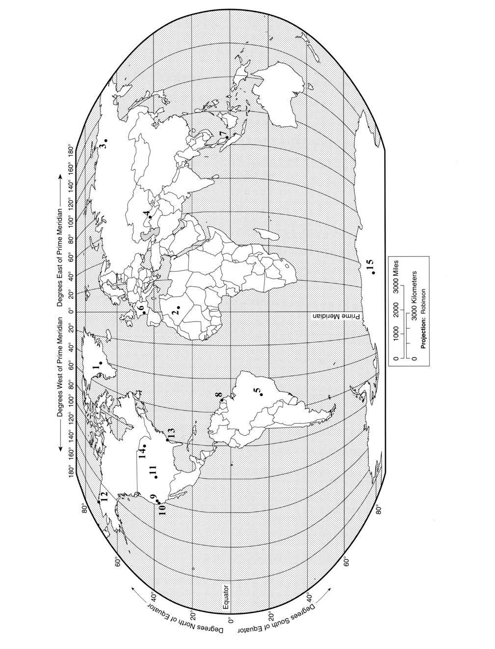
1 Introduction LAB J - WORLD CLIMATE ZONES The objective of this lab is to familiarize the student with the various climates around the world and the climate controls that influence these climates. Students will also be introduced to climographs, a graphic presentation of the temperature and precipitation averages (climate) for individual locations (stations). The chief advantage of using climographs is the visual representation of a full year of data for easy station to station comparison. Monthly average temperatures are shown by means of a line graph. Monthly average precipitation totals are shown by a bar graph. Materials needed: lecture notes only Part I. Locations, Climate Names and Symbols The following pages contain 14 climographs for various stations around the world. Using what you have learned in lecture, examine each of the climographs paying special attention to the temperature and precipitation characteristics. After answering the questions regarding the patterns and variability in the temperatures and precipitation, you should be able to assign the Köppen symbol and climate name for each location. Finally, your instructor will assign each group four of the locations (climographs) from those on pages J-3 through J-. Determine the climate controls that influence each location and discuss their influence on that location s climate. The climate controls discussed in the text and during lecture were: Latitude (sun angle insolation), Atmospheric Circulation (pressure zones, winds, shift in the ITCZ), Air Masses (E, cp, ca, mp, ct, mt), Ocean Currents (warm, cool, cold water), Elevation, Topography (mountain barriers), Continentality (location interior to a continent), or land-water heating contrast and Storms. Try to be specific when discussing a control, for example, name the ocean current and state if it is warm or cool-cold and what influence the current has toward the climate of that location. The climograph on Page J-2 has been completed. Review this climograph and use it as a model for the rest of the lab. J-1
2 Climograph A: through the seasons? Moderate difference between summer and winter temperatures. Winter (Nov Jan) mild, summer (Jun Aug) warm. a. Highest: 7 F b. Lowest: 42 F c. Range: 28 F 3. Describe the pattern of precipitation in terms of yearly amount and seasonality? This location receives an even distribution of precipitation no dry season. Each month receives at least two inches of precipitation for a total of about 3 inches. Climate Name: Marine West Coast Köppen Symbol: Cfb location? Latitude: located in the Northern Hemisphere midlatitudes. This location results in a moderately large difference between winter and summer average temperatures (Jan. 43 F Jul. 7 F) Maritime Location: adjacent to the Atlantic Ocean, water serves to moderate both winter and summer temperatures. North Atlantic Current is a warm current which keeps the average temperatures in the winter fairly warm. The extremes of more interior/inland locations (continentality) are absent. Atmospheric Circulation/Air Masses: In the zone of the Westerlies. West coast France receives moist, cool (mp) air year round. No dry season. A moderate, moist climate. Bordeaux, France location #6 on map of the world J-2
3 Climograph B J-3
4 Climograph C J-4
5 Climograph D J-
6 Climograph E J-6
7 Climograph F J-7
8 Climograph G J-8
9 Climograph H J-9
10 Climograph I J-1
11 Climograph J J-11
12 Climograph K J-12
13 Climograph L J-13
14 Climograph M J-14
15 Climograph N J-
16 J-16
17 Part II. Stations (locations) and Climate Descriptions From the following descriptions, identify the applicable climate name and write it in the space provided. 1. Located -7 miles inland of a west coast mountain range approximately 3 to 4 North latitude. Dry, hot summer. 2. Located on a west coast at approximately 3 to 4 North. Dry, warm summer. Similar to Santiago,Chile. 3. Located near an east coast at approximately 3 North or South. No dry season. Hot, humid summers. Frequent hurricanes Summer to late Fall. 4. Location with the greatest annual temperature range.. Location with the least annual temperature range. 6. Located where cp and mt air masses are in constant contact. 7. Climate class determined by this city's elevation, and its "rain shadow" location. Marine West Coast 8. Located on a west coast at 4 - North. Climate influenced by mp air masses. A moderate, moist climate. 9. Precipitation values describe a BWk climate but this desert is "frozen". 1. Large temperature range with very hot summers and very low precipitation mark this climate type. 11. A dry region, far from moisture sources, 4 - North. 12. Large amounts of precipitation with winter dry, little temperature change over the year. 13. Enormous summer rains occur after a short dry period. 14. A polar climate, but with no true summer. Warmest month between 32 F and F. J-17
Keys to Climate Climate Classification Low Latitude Climates Midlatitude Climates High Latitude Climates Highland Climates Our Changing Climate
 Climate Global Climates Keys to Climate Climate Classification Low Latitude Climates Midlatitude Climates High Latitude Climates Highland Climates Our Changing Climate Keys to Climate Climate the average
Climate Classification Chapter 7
 Climate Classification Chapter 7 Climate Systems Earth is extremely diverse No two places exactly the same Similarities between places allow grouping into regions Climates influence ecosystems Why do we
Prentice Hall EARTH SCIENCE
 Prentice Hall EARTH SCIENCE Tarbuck Lutgens Chapter 21 Climate 21.1 Factors That Affect Climate Factors That Affect Climate Latitude As latitude increases, the intensity of solar energy decreases. The
Prentice Hall EARTH SCIENCE
 Prentice Hall EARTH SCIENCE Tarbuck Lutgens Chapter 21 Climate 21.1 Factors That Affect Climate Factors That Affect Climate Latitude As latitude increases, the intensity of solar energy decreases. The
Climate Classification
 Chapter 15: World Climates The Atmosphere: An Introduction to Meteorology, 12 th Lutgens Tarbuck Lectures by: Heather Gallacher, Cleveland State University Climate Classification Köppen classification:
Bell Work. REVIEW: Our Planet Earth Page 29 Document A & B Questions
 9.12.16 Bell Work REVIEW: Our Planet Earth Page 29 Document A & B Questions Intro to Climate & Weather https://www.youtube.com/watch?v=vhgyoa70q7y Weather vs. Climate Video Climate & Weather 3.1 Weather
Average temperature ( F) World Climate Zones. very cold all year with permanent ice and snow. very cold winters, cold summers, and little rain or snow
 World Climate Zones. very cold all year with permanent ice and snow. very cold winters, cold summers, and little rain or snow") P r e v i e w Look carefully at the climagraph of Mumbai, India. What is the wettest month (or months) in Mumbai? What is the driest month (or months) in Mumbai? What effects might this city s climate
P r e v i e w Look carefully at the climagraph of Mumbai, India. What is the wettest month (or months) in Mumbai? What is the driest month (or months) in Mumbai? What effects might this city s climate
The Global Scope of Climate. The Global Scope of Climate. Keys to Climate. Chapter 8
 The Global Scope of Climate Chapter 8 The Global Scope of Climate In its most general sense, climate is the average weather of a region, but except where conditions change very little during the course
Factors That Affect Climate
 Factors That Affect Climate Factors That Affect Climate Latitude As latitude (horizontal lines) increases, the intensity of solar energy decreases. The tropical zone is between the tropic of Cancer and
Physical Features of Monsoon Asia. 192 Unit 7 Teachers Curriculum Institute 60 N 130 E 140 E 150 E 60 E 50 N 160 E 40 N 30 N 150 E.
 50 N 60 E 70 E 80 E 90 E 100 E 60 N 110 E 120 E 130 E 140 E 150 E 50 N 160 E 40 N 40 N 30 N 60 E 30 N 150 E Tropic of Cancer 20 N Tropic of Cancer 20 N 10 N 10 N 0 Equator 0 Equator 10 S 10 S 0 500 1,000
16 Global Climate. Learning Goals. Summary. After studying this chapter, students should be able to:
 16 Global Climate Learning Goals After studying this chapter, students should be able to: 1. associate the world s six major vegetation biomes to climate (pp. 406 408); 2. describe methods for classifying
Energy Systems, Structures and Processes Essential Standard: Analyze patterns of global climate change over time Learning Objective: Differentiate
 Energy Systems, Structures and Processes Essential Standard: Analyze patterns of global climate change over time Learning Objective: Differentiate between weather and climate Global Climate Focus Question
Regents Earth Science Unit 7: Water Cycle and Climate
 Regents Earth Science Unit 7: Water Cycle and Climate Name Section Coastal and Continental Temperature Ranges Lab # Introduction: There are large variations in average monthly temperatures among cities
Name: Regents Earth Science. Weather and Climate - Review Questions
 Name: Regents Earth Science Weather and Climate - Review Questions Date: Thayer - 279 1. People sometimes release substances into the atmosphere to increase the probability of rain by A) raising the air
Adopt a Drifter Lesson Plan by Mary Cook, Middle School Science Teacher, Ahlf Jr. High School, Searcy, Arkansas
 Adopt a Drifter Lesson Plan by Mary Cook, Middle School Science Teacher, Ahlf Jr. High School, Searcy, Arkansas Do Ocean Surface Currents Influence Climate? Objectives Students will construct climographs
L.O Students will learn about factors that influences the environment
 Name L.O Students will learn about factors that influences the environment Date 1. At the present time, glaciers occur mostly in areas of A) high latitude or high altitude B) low latitude or low altitude
Mediterranean Climates (Csa, Csb)
") Climatic Zones & Types Part II I've lived in good climate, and it bores the hell out of me. I like weather rather than climate. 1 John Steinbeck Mediterranean Climates (Csa, Csb) Main locations Western
Climatic Zones & Types Part II I've lived in good climate, and it bores the hell out of me. I like weather rather than climate. 1 John Steinbeck Mediterranean Climates (Csa, Csb) Main locations Western
Mid-latitude Cyclones & Air Masses
 Lab 9 Mid-latitude Cyclones & Air Masses This lab will introduce students to the patterns of surface winds around the center of a midlatitude cyclone of low pressure. The types of weather associated with
Earth s Climates. Understanding Weather and Climate. Chapter 15 Lecture. Seventh Edition
 Chapter 15 Lecture Understanding Weather and Climate Seventh Edition Earth s Climates Frode Stordal, University of Oslo Redina L. Herman Western Illinois University Climate and Controlling Factors Climate
Global Climates. Name Date
 Global Climates Name Date No investigation of the atmosphere is complete without examining the global distribution of the major atmospheric elements and the impact that humans have on weather and climate.
Lecture Outlines PowerPoint. Chapter 20 Earth Science 11e Tarbuck/Lutgens
 Lecture Outlines PowerPoint Chapter 20 Earth Science 11e Tarbuck/Lutgens 2006 Pearson Prentice Hall This work is protected by United States copyright laws and is provided solely for the use of instructors
All objects emit radiation. Radiation Energy that travels in the form of waves Waves release energy when absorbed by an object. Earth s energy budget
 Radiation Energy that travels in the form of waves Waves release energy when absorbed by an object Example: Sunlight warms your face without necessarily heating the air Shorter waves carry more energy
Elements of weather and climate Temperature Range of temperature Seasonal temperature pattern Rainfall
 Climate Earth Science Chapter 20 Pages 560-573 Elements of weather and climate Temperature Range of temperature Seasonal temperature pattern Rainfall Overall rainfall Seasonal distribution of rainfall
Chapter 3 Section 3 World Climate Regions In-Depth Resources: Unit 1
 Guided Reading A. Determining Cause and Effect Use the organizer below to show the two most important causes of climate. 1. 2. Climate B. Making Comparisons Use the chart below to compare the different
Tropical Moist Rainforest
 Tropical or Lowlatitude Climates: Controlled by equatorial tropical air masses Tropical Moist Rainforest Rainfall is heavy in all months - more than 250 cm. (100 in.). Common temperatures of 27 C (80 F)
Grade 9 Geography Chapter 11 - Climate Connections
 Grade 9 Geography Chapter 11 - Climate Connections 1. Define: Weather. 2. In what way has weather affected your activities in the last two weeks? 3. Define: Climate. 4. Canada s climate is a function of
PART II. Physical Landscape Chapters 2 5 CLIMATE CLIMATE STUDYING CLIMATE R E M I N D E R S. PART II: People and their Physical Environment 10/26/2017
 R E M I N D E R S Two required essays are due by Nov. 13, 2017. (A third may be used for extra credit in place of a Think Geographically essay.) ESSAY TOPIS (choose any two): ontributions of a noted geographer,
CLIMATE. UNIT TWO March 2019
 CLIMATE UNIT TWO March 2019 OUTCOME 9.2.1Demonstrate an understanding of the basic features of Canada s landscape and climate. identify and locate major climatic regions of Canada explain the characteristics
LAB 19. Lab 19. Differences in Regional Climate: Why Do Two Cities Located at the Same Latitude and Near a Body of Water Have Such Different Climates?
 Lab Handout Lab 19. Differences in Regional Climate: Why Do Two Cities Located at the Same Latitude and Near a Body of Water Have Such Different Climates? Introduction Weather describes the current atmospheric
World geography 3200/3202 Unit 2 review
 World geography 3200/3202 Unit 2 review 1. Does this statement use the terms revolve & rotate correctly? "Saturn revolves on its axis while several moons rotate around it." 2. Does this statement use the
1 What Is Climate? TAKE A LOOK 2. Explain Why do areas near the equator tend to have high temperatures?
 CHAPTER 17 1 What Is Climate? SECTION Climate BEFORE YOU READ After you read this section, you should be able to answer these questions: What is climate? What factors affect climate? How do climates differ
Global Wind Patterns
 Name: Earth Science: Date: Period: Global Wind Patterns 1. Which factor causes global wind patterns? a. changes in the distance between Earth and the Moon b. unequal heating of Earth s surface by the Sun
Climates of Earth. Lesson Outline LESSON 1. A. What is climate? 1. is the long-term average weather conditions that occur in a particular region.
 Lesson Outline LESSON 1 A. What is climate? 1. is the long-term average weather conditions that occur in a particular region. 2. Climate depends on how average weather conditions throughout the year. B.
Climate. Annual Temperature (Last 30 Years) January Temperature. July Temperature. Average Precipitation (Last 30 Years)
 January Temperature. July Temperature. Average Precipitation (Last 30 Years)") Climate Annual Temperature (Last 30 Years) Average Annual High Temp. (F)70, (C)21 Average Annual Low Temp. (F)43, (C)6 January Temperature Average January High Temp. (F)48, (C)9 Average January Low Temp.
Climate Annual Temperature (Last 30 Years) Average Annual High Temp. (F)70, (C)21 Average Annual Low Temp. (F)43, (C)6 January Temperature Average January High Temp. (F)48, (C)9 Average January Low Temp.
Physical Geography Lab Activity #16
 Physical Geography Lab Activity #16 Due date Name California Climate Classification COR Objective 6, SLO 3 16.1. Introduction One of the most important factors in the physical geography of a place is its
Lecture #14 March 29, 2010, Monday. Air Masses & Fronts
 Lecture #14 March 29, 2010, Monday Air Masses & Fronts General definitions air masses source regions fronts Air masses formation types Fronts formation types Air Masses General Definitions a large body
Climate Chapter 19. Earth Science, 10e. Stan Hatfield and Ken Pinzke Southwestern Illinois College
 Climate Chapter 19 Earth Science, 10e Stan Hatfield and Ken Pinzke Southwestern Illinois College The climate system A. Climate is an aggregate of weather B. Involves the exchanges of energy and moisture
ATSC 2000 Final Fall 2005
 ATSC 2000 Final Fall 2005 true/false /25 multiple choice /25 short answer /23 essay /10 total /83 or % True/False Indicate whether the sentence or statement is true or false. (25 questions 1% each) 1.
1. Which weather map symbol is associated with extremely low air pressure? A) B) C) D) 2. The diagram below represents a weather instrument.
 B) C) D) 2. The diagram below represents a weather instrument.") 1. Which weather map symbol is associated with extremely low air pressure? 2. The diagram below represents a weather instrument. Which weather variable was this instrument designed to measure? A) air pressure
1. Which weather map symbol is associated with extremely low air pressure? 2. The diagram below represents a weather instrument. Which weather variable was this instrument designed to measure? A) air pressure
Detect patterns in the distribution of temperatures on the earth s surface
 Detect patterns in the distribution of temperatures on the earth s surface Greenhouse Effect Is this a Good thing or a BAD thing?????? Greenhouse Effect The greenhouse effect is often misunderstood and
Seasons, Global Wind and Climate Study Guide
 Seasons, Global Wind and Climate Study Guide Seasons 1. Know what is responsible for the change in seasons on Earth. 2. Be able to determine seasons in the northern and southern hemispheres given the position
GLOBAL CLIMATES FOCUS
 which you will learn more about in Chapter 6. Refer to the climate map and chart on pages 28-29 as you read the rest of this chapter. FOCUS GLOBAL CLIMATES What are the major influences on climate? Where
Air Masses of North America cp and ca air masses Air mass characterized by very cold and dry conditions
 Chapter 8: Air Masses, Fronts, and Middle-Latitude Cyclones Air masses Fronts Middle-latitude cyclones Air Masses Air mass an extremely large body of air whose properties of temperature and humidity are
Foundations of Earth Science, 6e Lutgens, Tarbuck, & Tasa
 Foundations of Earth Science, 6e Lutgens, Tarbuck, & Tasa Weather Patterns and Severe Weather Foundations, 6e - Chapter 14 Stan Hatfield Southwestern Illinois College Air masses Characteristics Large body
Climate Regions. Combining Climate Graphs and Köppen s Classification
 Lab 15 Climate Regions Combining knowledge of the global patterns behind the major climatic controls, this lab will teach students how to construct climate graphs and then allow them to explore patterns
CLIMATE DEFINED CLIMATE INFLUENCES STUDYING CLIMATE R E M I N D E R S. PART II: People and their 10/19/2018
 R E M I N D E R S Two required essays are due by Oct. 30, 2018. (A third may be used for extra credit in place of a Think Geographically essay.) ESSAY TOPIS (choose any two): ontributions of a noted geographer,
General Circulation. Nili Harnik DEES, Lamont-Doherty Earth Observatory
 General Circulation Nili Harnik DEES, Lamont-Doherty Earth Observatory nili@ldeo.columbia.edu Latitudinal Radiation Imbalance The annual mean, averaged around latitude circles, of the balance between the
Module 11: Meteorology Topic 3 Content: Climate Zones Notes
 Introduction Latitude is such an important climate factor that you can make generalizations about a location's climate based on its latitude. Areas near the equator or the low latitudes are generally hot
DEPARTMENT OF EARTH & CLIMATE SCIENCES Name SAN FRANCISCO STATE UNIVERSITY Nov 29, ERTH 360 Test #2 200 pts
 DEPARTMENT OF EARTH & CLIMATE SCIENCES Name SAN FRANCISCO STATE UNIVERSITY Nov 29, 2018 ERTH 360 Test #2 200 pts Each question is worth 4 points. Indicate your BEST CHOICE for each question on the Scantron
Wind: Global Systems Chapter 10
 Wind: Global Systems Chapter 10 General Circulation of the Atmosphere General circulation of the atmosphere describes average wind patterns and is useful for understanding climate Over the earth, incoming
1 What Is Climate? TAKE A LOOK 2. Explain Why do areas near the equator tend to have high temperatures?
 CHAPTER 17 1 What Is Climate? SECTION Climate BEFORE YOU READ After you read this section, you should be able to answer these questions: What is climate? What factors affect climate? How do climates differ
The Atmosphere. Importance of our. 4 Layers of the Atmosphere. Introduction to atmosphere, weather, and climate. What makes up the atmosphere?
 The Atmosphere Introduction to atmosphere, weather, and climate Where is the atmosphere? Everywhere! Completely surrounds Earth February 20, 2010 What makes up the atmosphere? Argon Inert gas 1% Variable
Fig Major air masses of the world
 Fig. 9.3 Major air masses of the world CLASSIFICATION FOUR BASIC CATEGORIES OF AIR MASSES: POLAR - P ARCTIC - A TROPICAL - T EQUATORIAL - E TWO DESIGNATIONS OF SURFACE IN SOURCE REGION MARITIME - m. CONTINENTAL
February 23, U3 D1 Air Masses.notebook
 Bellringer Pre Assessment: What contributing factors influence the differences in climates? What's the difference between a cold front and a warm front? What are some of the Air masses that effect North
Climate. Earth Science Chapter 20 Pages
 Academic Excellence Showcase Thursday, May 27 Two points credit for each talk you attend in Earth science 8:30 to 10:30 AM, in NS 101 General Science video productions: Energy 9:00 to 11:00 AM, in NS 218
Our climate system is based on the location of hot and cold air mass regions and the atmospheric circulation created by trade winds and westerlies.
 CLIMATE REGIONS Have you ever wondered why one area of the world is a desert, another a grassland, and another a rainforest? Or have you wondered why are there different types of forests and deserts with
RR#4 - Multiple Choice
 1. The map below shows the amount of snowfall, in inches, produced by a lake-effect snowstorm in central New York State. The wind that produced this snowfall pattern most likely came from the 1) northeast
Contents. Section 1: Climate Factors. Section 2: Climate Types. Section 3: Climate Effects
 Contents Section 1: Climate Factors 1. Weather or Climate?.... 2 2. Elements of Climate.... 4 3. Factors Affecting Climate.... 10 4. Comparing Climates.... 15 5. Quiz 1.... 20 Section 2: Climate Types
I. Definitions. A. Weather--day by day variations in temperature (temp), winds, pressure and precipitation (ppt)
, winds, pressure and precipitation (ppt)") CLIMATE UNIT I. Definitions A. Weather--day by day variations in temperature (temp), winds, pressure and precipitation (ppt) B. Climate--average seasonal weather for an area, usually described in terms
CLIMATE UNIT I. Definitions A. Weather--day by day variations in temperature (temp), winds, pressure and precipitation (ppt) B. Climate--average seasonal weather for an area, usually described in terms
CLIMATE CLIMATE STUDYING CLIMATE. PART II: People and their 3/20/2018. GEOG 101 Part II People and their Physical Environment R E M I N D E R S
 Two required essays are due by March 27, 2018. (A third may be used for extra credit in place of a Think Geographically essay.) ESSAY TOPIS (choose any two): ontributions of a noted geographer, earth scientist
2. Would you expect convection in a lake? Why or why not?
 NAME: PERIOD: DATE: ENTRY NUMBER: REVIEW FOR WEATHER AND CLIMATE TEST 1. Describe 3 types of heat transfer. Give an example of each. 2. Would you expect convection in a lake? Why or why not? 3. What part
What factors affect climate? Dr. Michael J Passow
 What factors affect climate? Dr. Michael J Passow Energy from the Sun (mostly light and heat) radiates to Earth SUN 150 x 10 6 km (92 x 10 6 mi) EARTH Challenge: If the speed of light is 300,000 km/sec,
Air Masses and Fronts
 Air Masses and Fronts AT 350: Ahrens Chapter 12 Air Mass Properties Air masses take on the properties of the underlying surface Air masses are classified according to their location of origin Geographical
25.1 Air Masses. Section 25.1 Objectives
 Section 25.1 Objectives Explain how an air mass forms. List the four main types of air masses. Describe how air masses affect the weather of North America. Air Masses 25.1 Air Masses Differences in air
- air masses. Further Reading: Chapter 08 of the text book. Outline. - air masses of the world and of N. America. - fronts: warm, cold and occluded
 (1 of 10) Further Reading: Chapter 08 of the text book Outline - air masses - air masses of the world and of N. America - fronts: warm, cold and occluded (2 of 10) Previously, Introduction We discussed
PART II. Physical Landscape Chapters 2 5 CLIMATE CLIMATE STUDYING CLIMATE R E M I N D E R S. PART II: People and their Physical Environment 10/19/2017
 R E M I N D E R S Two required essays are due by Nov. 13, 2017. (A third may be used for extra credit in place of a Think Geographically essay.) ESSAY TOPIS (choose any two): ontributions of a noted geographer,
Weather Atmospheric condition in one place during a limited period of time Climate Weather patterns that an area typically experiences over a long
 Weather Atmospheric condition in one place during a limited period of time Climate Weather patterns that an area typically experiences over a long period of time Many factors influence weather & climate
3) What is the difference between latitude and longitude and what is their affect on local and world weather and climate?
 What is the difference between latitude and longitude and what is their affect on local and world weather and climate?") www.discoveryeducation.com 1) Describe the difference between climate and weather citing an example of each. Describe how water (ocean, lake, river) has a local effect on weather and climate and provide
www.discoveryeducation.com 1) Describe the difference between climate and weather citing an example of each. Describe how water (ocean, lake, river) has a local effect on weather and climate and provide
SEVERE WEATHER AND FRONTS TAKE HOME QUIZ
 1. Most of the hurricanes that affect the east coast of the United States originally form over the A) warm waters of the Atlantic Ocean in summer B) warm land of the southeastern United States in summer
Climate and the Atmosphere
 Climate and Biomes Climate Objectives: Understand how weather is affected by: 1. Variations in the amount of incoming solar radiation 2. The earth s annual path around the sun 3. The earth s daily rotation
Air Masses and Fronts. Ahrens Chapter 12
 Air Masses and Fronts Ahrens Chapter 12 Air Mass Properties Air masses take on the properties of the underlying surface Air masses are classified according to their location of origin Geographical Characteristics
Unit 5 Part 2 Test PPT
 Unit 5 Part 2 Test PPT Standard 1: Air Masses Air Mass An air mass is an immense body of air that is characterized by similar temperatures and amounts of moisture at any given altitude When an air mass
Name SOLUTIONS T.A./Section Atmospheric Science 101 Homework #6 Due Thursday, May 30 th (in class)
") Name SOLUTIONS T.A./Section Atmospheric Science 101 Homework #6 Due Thursday, May 30 th (in class) 1. General Circulation Briefly describe where each of the following features is found in the earth s general
Name SOLUTIONS T.A./Section Atmospheric Science 101 Homework #6 Due Thursday, May 30 th (in class) 1. General Circulation Briefly describe where each of the following features is found in the earth s general
Regional Climatology. Lab Number Two (10pts) Climatic Classification and Polar Climates
 Climatic Classification and Polar Climates") Name: Time of Class: Due Date: Regional Climatology Lab Number Two (10pts) Climatic Classification and Polar Climates Part I: Group Discussion and Answer Directions: Arrange a group of three individuals.
Name: Time of Class: Due Date: Regional Climatology Lab Number Two (10pts) Climatic Classification and Polar Climates Part I: Group Discussion and Answer Directions: Arrange a group of three individuals.
Name Period Part I: INVESTIGATING OCEAN CURRENTS: PLOTTING BUOY DATA
 Name Period Part I: INVESTIGATING OCEAN CURRENTS: PLOTTING BUOY DATA INTRODUCTION: Ocean currents are like huge rivers in the sea. They carry drifting organisms, vital dissolved chemical nutrients and
Earth Science Lesson Plan Quarter 2, Week 6, Day 1
 Earth Science Lesson Plan Quarter 2, Week 6, Day 1 1 Outcomes for Today Standard Focus: Earth Sciences 5.f students know the interaction of wind patterns, ocean currents, and mountain ranges results in
Weather and Climate of the Rogue Valley By Gregory V. Jones, Ph.D., Southern Oregon University
 Weather and Climate of the Rogue Valley By Gregory V. Jones, Ph.D., Southern Oregon University The Rogue Valley region is one of many intermountain valley areas along the west coast of the United States.
Earth s Climate Patterns
 Earth s Climate Patterns Reading: Chapter 17, GSF 10/2/09 Also Jackson (linked on course web site) 1 What aspects of climate affect plant distributions? Climate: long-term distribution of weather in an
What a Hurricane Needs to Develop
 Weather Weather is the current atmospheric conditions, such as air temperature, wind speed, wind direction, cloud cover, precipitation, relative humidity, air pressure, etc. 8.10B: global patterns of atmospheric
Funding provided by NOAA Sectoral Applications Research Project CLIMATE. Basic Climatology Colorado Climate Center
 Funding provided by NOAA Sectoral Applications Research Project CLIMATE Basic Climatology Colorado Climate Center Remember These? Factor 1: Our Energy Source Factor 2: Revolution & Tilt Factor 3: Rotation!
GEOGRAPHY 1114 LABORATORY EXAM Points possible LAB TIME/DAY 2 points per question CHOOSE THE BEST ANSWER IT SHOULD BE BEST BY FAR
 GEOGRAPHY 1114 LABORATORY EXAM 1 Spring 2011 NAME TEACHING ASSISTANT 50 Points possible LAB TIME/DAY 2 points per question CHOOSE THE BEST ANSWER IT SHOULD BE BEST BY FAR ANSWER ALL QUESTIONS IN PENCIL
Global Winds AOSC 200 Tim Canty
 Global Winds AOSC 200 Tim Canty Class Web Site: http://www.atmos.umd.edu/~tcanty/aosc200 Topics for today: Air Masses Fronts Lecture 18 Oct 31 2017 1 Air Masses What is an air mass? Large body of air whose
AOSC 200 Tim Canty. Class Web Site: Topics for today: Air Masses. Fronts. Lecture 19 Apr
 Air Masses AOSC 200 Tim Canty Class Web Site: http://www.atmos.umd.edu/~tcanty/aosc200 Topics for today: Air Masses Fronts Lecture 19 Apr 11 2019 1 Today s Weather Map http://www.wpc.ncep.noaa.gov/#page=sfc
2. Fargo, North Dakota receives more snow than Charleston, South Carolina.
 2015 National Tournament Division B Meteorology Section 1: Weather versus Climate Chose the answer that best answers the question 1. The sky is partly cloudy this morning in Lincoln, Nebraska. 2. Fargo,
3. The map below shows an eastern portion of North America. Points A and B represent locations on the eastern shoreline.
 1. Most tornadoes in the Northern Hemisphere are best described as violently rotating columns of air surrounded by A) clockwise surface winds moving toward the columns B) clockwise surface winds moving
Climate versus Weather
 Climate versus Weather What is climate? Climate is the average weather usually taken over a 30-year time period for a particular region and time period. Climate is not the same as weather, but rather,
ALL PRESSURE VARIABLES AND STATION MODELS MEGA PACKET
 NAME: MEGA PACKET 1. A change in the type and location of large high-pressure systems (H) and large low-pressure systems ( L) over Asia creates shifts in prevailing winds that cause a rainy summer season
Weather Patterns and Severe Storms
 Weather Patterns and Severe Storms 20.1 Air Masses Air Masses and Weather Air Masses An air mass is an immense body of air that is characterized by similar temperatures and amounts of moisture at any given
Weather Practice Test
 Name: Weather Practice Test 1. The diagram below shows weather instruments A and B. Which table correctly indicates the name of the weather instrument and the weather variable that it measures? A) B) C)
Factors that Affect Climate
 Factors that Affect Climate What is climate? Climate is the average weather conditions over a long period of time Includes average temperatures and precipitation, wind patterns, humidity, air pressure
b. The boundary between two different air masses is called a.
 NAME Earth Science Weather WebQuest Part 1. Air Masses 1. Find out what an air mass is. http://okfirst.mesonet.org/train/meteorology/airmasses.html a. What is an air mass? An air mass is b. The boundary
Weather Atmospheric condition in one place during a limited period of time Climate Weather patterns that an area typically experiences over a long
 Weather Atmospheric condition in one place during a limited period of time Climate Weather patterns that an area typically experiences over a long period of time Many factors influence weather & climate
Weather and Climate Power Point
 Weather and Climate Power Point Atmospheric Composition Our air is made up of: 78% Nitrogen 21% Oxygen 0-4% Water Vapor 0.93% Argon.038% Carbon Dioxide 0.01% Trace Gases (Carbon dioxide has increased from
What is Climate? Understanding and predicting climatic changes are the basic goals of climatology.
 What is Climate? Understanding and predicting climatic changes are the basic goals of climatology. Climatology is the study of Earth s climate and the factors that affect past, present, and future climatic
Weather and Climate A B1
 Weather and Climate A B1 1. What causes the Coriolis effect? (1) Earth s tilt on its axis (2) the spin of Earth on its axis (3) the orbital motion of the Moon around Earth (4) the orbital motion of Earth
Chapter 21. Weather Patterns and Severe Storms
 Chapter 21 Weather Patterns and Severe Storms 20.1 Air Masses Air Masses and Weather Air Masses An air mass is an immense body of air that is characterized by similar temperatures and amounts of moisture
Activity #2 - Major Ocean Surface Currents
 Activity #2 - Major Ocean Surface Currents Concepts # 3 & 6 # 3 Atmospheric cells and ocean gyres redistribute heat from low to high latitudes, which influences climate, weather, and ocean temperature.
Third Grade Math and Science DBQ Weather and Climate/Representing and Interpreting Charts and Data
 Third Grade Math and Science DBQ Weather and Climate/Representing and Interpreting Charts and Data A document based question (DBQ) is an authentic assessment where students interact with content related
Climate.tgt, Version: 1 1
 Name: Key Concepts Choose the letter of the best answer. (5 points each) 1. 2. 3. 4. 5. 6. 7. 8. 9. 10. Date: A city located in the middle of North America experiences extreme temperature changes during
Social Studies. Chapter 2 Canada s Physical Landscape
 Social Studies Chapter 2 Canada s Physical Landscape Introduction Canada s geography its landforms and climate - has a great impact on Canadians sense of identity. Planet Earth The earth is divided into