Programs of Regione Campania for reduction of seismic risk (and others)
|
|
|
- Stephen Lester
- 6 years ago
- Views:
Transcription
1 Programs of Regione Campania for reduction of seismic risk (and others) Prof ing Edoardo Cosenza Assessore (Regional Ministry) Public Works and Civil Protection Regione Campania
2 Napoli, 1900.
3
4 Impossibile visualizzare l'immagine. La memoria del computer potrebbe essere insufficiente per aprire l'immagine oppure l'immagine potrebbe essere danneggiata. Riavviare il computer e aprire di nuovo il file. Se viene visualizzata di nuovo la x rossa, potrebbe essere necessario eliminare l'immagine e inserirla di nuovo. Last eruption: March 1944
5 US Soldier, 1944
6 May 1998, 165 deaths
7


8 September 9, 2010


 36")
 36 anemometers (wind")

9 Real-time Meteohydropluviometric Monitoring Network of the Campania Region Functional Decentralized Centre Current stations and sensors (september 2011) 192 real-time monitoring stations equipped with: 178 pluviometers 63 hd hydrometers 99 air thermometers 34 soil thermometers 45 hygrometers (air moisture content) 36 barometers (atmospheric pressure) 36 anemometers (wind speed and direction) 35 radiometers (total radiant flux) 3 snow gauges 5 freatimeters 2 soil hygrometers 3 ocean current meters


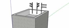
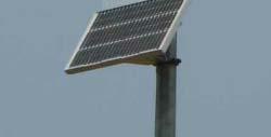
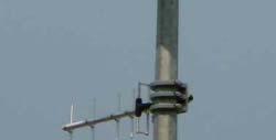
10 Real-time Meteohydropluviometric Monitoring Network of the Campania Region Functional Decentralized Centre Peripheric stations with electronic sensors, multitasking processors, front-end and its peripherals, solar panel, radio device with a transmitting antenna Solar panel Transmitting antenna Data are automatically ti acquired by sensors periodically, with different time frequency for each sensor. CPU unit buffered memory I.e., data from pluviometric sensors are registered every minute and submitted to a preliminary analysis for detection of errors and pre-validation Network controller radio battery
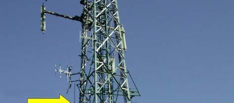
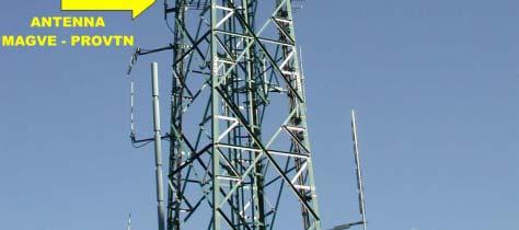
11 Real-time Meteohydropluviometric Monitoring Network of the Campania Region Functional Decentralized Centre Real-time data are transmitted every 10 minutes to the Elaboration Data Centre of Naples through repeaters by trophosperic radio link.


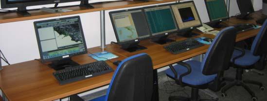
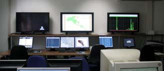
12 Real-time Meteohydropluviometric Monitoring Network of the Campania Region Functional Decentralized Centre SERVER SQL DataBase Data acquired from frontend system are elaborated, managed and spred by the informatics systems for the support of civil protection authorities in the real-time warning alert system for hydrogeological and hydraulic risk.
13 Regione Campania and natural risks Mission and Strategic Plan Development and implementation of forecasting, monitoring, i scenario models and risk management tools for: Flash floods and landslides; Heavy rainfalls; Earthquakes; Eruptions and volcano-related l phenomena. Sea waves;
14 Put in operation of a Multi-Risk Management Center for Meteohydropluviometric, Volcanic, Seismic risks. (AMRA should work as a center of compentence in this framework). Development of civil protection emergency management plans at regional, district, and municipal levels. Software and hardware supports. Development of communication strategy at a public level for risk understanding, management, and personal mitigation. This is to strenghten a risk management responsibility in communities.


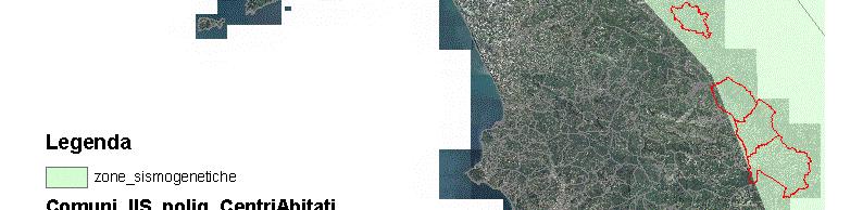
15 Campania seismic extended sources and 10% in 50 yr hazard map


16 Actions: Example of scenario modeling 500 yr return period earthquake scenarios in terms of magnitude and distance from probabilistic disaggregation. Site-by-site most probable earthquakes determining 500 yr accelaration.


17 Municipalities in Near Source regions (directivity effects) N. Municipalities i i On fault surface 68 projection In forward directivity- 74 prone regions Within zones with PGA 107 larger than 0.25g in 500 yr return period map
18 Actions: Seismic early warning has been alredy developed for Campania and it is going to exploited and extended beyond to other risks Structural/nonstructural performance/loss EDP (i.e. Maximum Interstory Drift Ratio) Engineering g Early Warning (1) Seismic network Epicenter IM (e.g. Peak Ground Acceleration PGA) Source-to-site distance Ground motion at the site Signal at the network stations Real-Time Risk Analysis (Performance-Based EW)
19 Engineering Early Warning (2)
20 Programs of Regione Canpamia for reduction of seismic risk (and others) Budget of 75 millions of euros European Funds - to be invested in the period
1 st results of the MICROSCOPE test of the equivalence principle in space. Manuel RODRIGUES
 1 st results of the MICROSCOPE test of the equivalence principle in space. Manuel RODRIGUES On behalf of the MICROSCOPE team STEP : THE MICROSCOPE ORIGINS Pr. Francis Everitt : PI of GPB & STEP had been
Reac%ve power pricing strategy
 Department of Informa-on Engineering University of Padova, ITALY Reac%ve power pricing strategy Giulia Maso, Mar-no Minella, Anna Polidoro Smart Grids Outline Model Reac-ve power compensa-on Pricing Tools
EARTH OBSERVATION SERVICES IN REPUBLIC OF MOLDOVA
 EARTH OBSERVATION SERVICES IN REPUBLIC OF MOLDOVA Vasile ALCAZ 1 Ion APOSTOL 2 1 Institute of Geology and Seismology Moldavian Academy of Sciences 2 Ministry of Environment and Natural Resources Republic
Monitoring and Warning Systems for Natural Phenomena The Mexican Experience
 Sistema Nacional de Protección Civil Monitoring and Warning Systems for Natural Phenomena The Mexican Experience Roberto Quaas W, Enrique Guevara O. O Mexican National Center for Disaster Prevention CENAPRED
Website Phone Mobile OVERVIEW Davis Vantage Pro2 Weather Station
 OVERVIEW If you're looking for a superior weather station, the Davis Vantage Pro2 Weather Station is as good as they come! Vantage Pro2 offers the professional weather observer and the serious weather
Republic of Mozambique
 Republic of Mozambique Second Expert's Symposium on Multi-Hazard Early Warning Systems with focus on the Role of National Meteorological and Hydrological Services 5-7 May 2009, Toulouse France 1. Background
SCIENCE OF TSUNAMI HAZARDS
 SCIENCE OF TSUNAMI HAZARDS ISSN 8755-6839 Journal of Tsunami Society International Volume 32 Number 1 2013 THE FRENCH TSUNAMI WARNING CENTER FOR THE MEDITERRANEAN AND NORTHEAST ATLANTIC: CENALT P. Roudil,
The regional early warning system for rainfall-induced landslides operating in Campania (Italy): performance evaluation of two warning strategies
: performance evaluation of two warning strategies") 1st IMEKO TC-4 International Workshop on Metrology for geotechnics 17-18 March 2016, Benevento (Italy) The regional early warning system for rainfall-induced landslides operating in Campania (Italy): performance
1st IMEKO TC-4 International Workshop on Metrology for geotechnics 17-18 March 2016, Benevento (Italy) The regional early warning system for rainfall-induced landslides operating in Campania (Italy): performance
Hazardous Weather and Flooding Preparedness. Hazardous Weather and Flooding Preparedness
 Hazardous Weather and Flooding Preparedness 1 A Cooperative Effort 2 Administrative Information Emergency exits and procedures Location of restrooms Mobile devices Procedure for questions Course materials
Disaster Risk Management in India. Kamal Kishore New Delhi, 27 October 2016
 Disaster Risk Management in India Kamal Kishore New Delhi, 27 October 2016 Hazard, Exposure and Vulnerability Disaster Prevention Mitigation Hurricane Matthew: Cuba & Haiti Emergency Response Coordination
Indian Ocean Tsunami Warning System: Example from the 12 th September 2007 Tsunami
 Indian Ocean Tsunami Warning System: Example from the 12 th September 2007 Tsunami Charitha Pattiaratchi 1 Professor of Coastal Oceanography, The University of Western Australia Email: chari.pattiaratchi@uwa.edu.au
TOOLS FOR RISK MANAGEMENT Related to climate change
 TOOLS FOR RISK MANAGEMENT Related to climate change copyright CONTENT 1 CLIMATE CHANGE AND ENVIRONMENTAL STUDIES 2 METHODS AND TOOLS DEVELOPED BY EGIS For infrastructures For urban areas For crisis management
Weather Merit Badge Worksheet Hiller Aviation Museum
 Weather Merit Badge Worksheet Hiller Aviation Museum This worksheet is not required but is designed to help you complete the Aviation Merit Badge requirements. No one can add to or subtract from the Boy
Nucleosintesi oltre il picco del Fe. Misure di ca3ura neutronica di interesse Astrofisico
 Nucleosintesi oltre il picco del Fe. Misure di ca3ura neutronica di interesse Astrofisico Introduc,on: Nuclear Astrophysics the majority of the chemical elements in the universe is produced through nuclear
The Civil Protection System of the Autonomous Region of Friuli Venezia Giulia (Italy)
") The Civil Protection System of the Autonomous Region of Friuli Venezia Giulia (Italy) Geol. Raffaele Lotto La Plata, November 2017 Friuli Venezia Giulia Autonomous Region Austria Pordenone Udine Gorizia
The Civil Protection System of the Autonomous Region of Friuli Venezia Giulia (Italy) Geol. Raffaele Lotto La Plata, November 2017 Friuli Venezia Giulia Autonomous Region Austria Pordenone Udine Gorizia
Figure 1. Daily variation of air temperature
 Comparative analysis of the meteorological data acquired on standard equipment and by automatic weather station of CAMPBELL SCIENTIFIC, INC Company Kudekov T.K. Director-General of the KAZHYDROMET 050022
Tsunami hazard risk and early warning projects at Global Geophysics Institute, Vietnam
 Tsunami hazard risk and early warning projects at Global Geophysics Institute, Vietnam presented by Dr Kelvin Berryman, GNS Science, New Zealand k.berryman@gns.cri.nz on behalf of Prof. Bui C. Que,, Director
Establishment and Operation of a Regional Tsunami Warning Centre
 Establishment and Operation of a Regional Tsunami Warning Centre Dr. Charles McCreery, Director NOAA Richard H. Hagemeyer Pacific Tsunami Warning Center Ewa Beach, Hawaii USA Why A Regional Tsunami Warning
Landslide monitoring system in Iceland. Harpa Grímsdóttir Jón Kristinn Helgason NVE, Oslo, October
 Landslide monitoring system in Iceland Harpa Grímsdóttir Jón Kristinn Helgason NVE, Oslo, October 26 2016 History Avalanches and landslides have caused extensive damages and loss of human lives in Iceland
Module 11: Meteorology Topic 3 Content: Weather Instruments Notes
 Introduction In order for meteorologists to accurately predict the weather, they take thousands of different weather measurements each day. Meteorologists need to use many tools in order to draw an accurate
WMO/WWRP FDP: INCA CE
 WMO/WWRP FDP: INCA CE Yong Wang ZAMG, Austria This project is implemented through the CENTRAL EUROPE Programme co-financed by the ERDF INCA CE: implementation over Central Europe A Nowcasting Initiative
Weather Station Case Study. Prepared by : Ahmad Mujahid Ubaidilllah Zakaria
 Weather Station Case Study Prepared by : Ahmad Mujahid Ubaidilllah Zakaria Overall system organization Weather Station WS1 WS2 WS3 WS.. WSn Satellite information Weather information system Weather radar
Detection of Antimatter in our Galaxy
 Impossibile visualizzare l'immagine. La memoria del computer potrebbe essere insu!ciente per aprire l'immagine oppure l'immagine potrebbe essere danneggiata. Riavviare il computer e aprire di nuovo il
Earthquake,Tsunami,Volcano Monitoring & Warning System in Korea. Jimin Lee Earthquake & Volcano Monitoring Division KMA
 Earthquake,Tsunami,Volcano Monitoring & Warning System in Korea Jimin Lee Earthquake & Volcano Monitoring Division KMA 1 2 Brief History & Vision of KMA Introduction of Services 3 Korea National Seismographic
Lab - Interpreting Weather Station Models.
 Name: Lab - Interpreting Weather Station Models. Date: Introduction The reporting of present weather conditions and the forecasting of future weather is the combined effort of thousands of weather stations
Product Description. 1 of 6
 Product Description The 6250 Vantage Vue Wireless Weather Station provides accurate, reliable weather monitoring in a self-contained, easy-to-install system. Designed to provide the weather data you need
DEVELOPMENT OF A FORECAST EARLY WARNING SYSTEM ethekwini Municipality, Durban, RSA. Clint Chrystal, Natasha Ramdass, Mlondi Hlongwae
 DEVELOPMENT OF A FORECAST EARLY WARNING SYSTEM ethekwini Municipality, Durban, RSA Clint Chrystal, Natasha Ramdass, Mlondi Hlongwae LOCATION DETAILS AND BOUNDARIES ethekwini Municipal Area = 2297 km 2
Seth J. Wittke Wyoming State Geological Survey
 Seth J. Wittke Wyoming State Geological Survey Project initiation Data manipulation Scenarios Creating the IMS Lessons learned County-wide block level probabilistic models created in 2004 for state mitigation
LAYMAN S REPORT Floods and Fire Risk Assessment and Management
 LAYMAN S REPORT Floods and Fire Risk Assessment and Management FLIRE is 50% co-financed by LIFE + financial instrument of the European Union. Floods and Fire risk assessment and management Project s code
Caribbean Early Warning System Workshop
 Caribbean Early Warning System Workshop Hamonization in Existing EWS April 14-16, 2016 Presenter: Shawn Boyce Caribbean Institute for Meteorology and Hydrology Husbands, St. James Barbados Background Between
Thunderstorm Forecasting and Warnings in the US: Applications to the Veneto Region
 Thunderstorm Forecasting and Warnings in the US: Applications to the Veneto Region Bill Conway Vice President Weather Decision Technologies Norman, Oklahoma, USA Andrea Rossa ARPAV Lead Scientist Centre
WM9280. Pro Family weather station with T/H sensor, pluviometer, anemometer, PC connection and Meteotime weather forecasts until 3 days
 Technical sheet Pro Family weather station with T/H sensor, pluviometer, anemometer, PC connection and Meteotime weather forecasts until 3 days RADIO-CONTROLLED TIME AND DATE - WEATHER FORECASTS FOR CURRENT
Disclaimer. This report was compiled by an ADRC visiting researcher (VR) from ADRC member countries.
 from ADRC member countries.") Disclaimer This report was compiled by an ADRC visiting researcher (VR) from ADRC member countries. The views expressed in the report do not necessarily reflect the views of the ADRC. The boundaries and
Disclaimer This report was compiled by an ADRC visiting researcher (VR) from ADRC member countries. The views expressed in the report do not necessarily reflect the views of the ADRC. The boundaries and
Formulation of the Strategy for Disaster Risk Reduction and Emergency Preparedness and Response of the Asia-Pacific Region
 2008/SOM3/TFEP/SEM/006 Formulation of the Strategy for Disaster Risk Reduction and Emergency Preparedness and Response of the Asia-Pacific Region 2009-2015 Submitted by: Thailand Emergency Management CEOs
The Civil Protection System of the Autonomous Region of Friuli Venezia Giulia (Italy) The response to hydro geological and alluvial risk
 The response to hydro geological and alluvial risk") The Civil Protection System of the Autonomous Region of Friuli Venezia Giulia (Italy) The response to hydro geological and alluvial risk Geol. Raffaele Lotto La Plata, November 2017 Friuli Venezia Giulia
The Civil Protection System of the Autonomous Region of Friuli Venezia Giulia (Italy) The response to hydro geological and alluvial risk Geol. Raffaele Lotto La Plata, November 2017 Friuli Venezia Giulia
Smart use of Geographic Information System (GIS) platform for delivering weather information and nowcasting services
 platform for delivering weather information and nowcasting services") Smart use of Geographic Information System (GIS) platform for delivering weather information and nowcasting services C. K. Pan Hong Kong Observatory Hong Kong, China It is a world of beauty Source: Image
Smart use of Geographic Information System (GIS) platform for delivering weather information and nowcasting services C. K. Pan Hong Kong Observatory Hong Kong, China It is a world of beauty Source: Image
MANAGEMENT OF THE NIEMEN RIVER BASIN WITH ACCOUNT OF ADAPTATION TO CLIMATE CHANGE. Hydro-meteorological Monitoring System
 MANAGEMENT OF THE NIEMEN RIVER BASIN WITH ACCOUNT OF ADAPTATION TO CLIMATE CHANGE Hydro-meteorological Monitoring System Draft Interim Report Milestone 1 Giovanni Crema 18 October 2012 Scope of work assessment
Progress Report. Flood Hazard Mapping in Thailand
 Progress Report Flood Hazard Mapping in Thailand Prepared By: Mr. PAITOON NAKTAE Chief of Safety Standard sub-beuro Disaster Prevention beuro Department of Disaster Prevention and Mitigation THAILAND E-mail:
What Are Disasters? The Rescue Kids Trio!
 The Rescue Kids Trio! What Are Disasters? This manual was made possible through funding by the Council of Local Authorities for International Relations. Disasters and emergency preparedness Emergency preparedness
The PREVIEW project: general objectives and an overview of the landslides platform
 The PREVIEW project: general objectives and an overview of the landslides platform Risk Mitigation for Earthquakes and Landslides Giacomo Falorni Earth Sciences Dept. University of Firenze 19-20 July 2007
CLIMATE CHANGE ASSESSMENT. A. Climate Change Risk Assessment and Adaptation Measures
 Solar Transmission Sector Project (RRP IND 49214) CLIMATE CHANGE ASSESSMENT I. Transmission System at Bhadla, Rajasthan A. Climate Change Risk Assessment and Adaptation Measures High temperature Risk is
networks from ISPRA GABRIELE NARDONE, MAURO BENCIVENGA, GIOVANNI ARENA
 The Italian observational networks from ISPRA retemareografica@isprambiente.itit reteondametrica@isprambiente.it GABRIELE NARDONE, MAURO BENCIVENGA, GIOVANNI ARENA ISPRA - RMN Italian Tide Gauge Network
The ITSU System in the Pacific Region and Future Upgrades
 The ITSU System in the Pacific Region and Future Upgrades Eddie Bernard Director, Pacific Marine Environmental Laboratory (PMEL) NOAA/USA Pacific Tsunami Warning Center OPERATIONAL ACTIVITIES SEISMIC DATA
FLORA: FLood estimation and forecast in complex Orographic areas for Risk mitigation in the Alpine space
 Natural Risk Management in a changing climate: Experiences in Adaptation Strategies from some European Projekts Milano - December 14 th, 2011 FLORA: FLood estimation and forecast in complex Orographic
Correcting Real Time Automatic Weather Stations Data Through Quality Checks and Analysis
 Correcting Real Time Automatic Weather Stations Data Through Quality Checks and Analysis Sd. Thouseef Ahmed Shoaib and Syed Nayab Rasool Andhra Pradesh State Development Planning Society, Hyderabad Email:
Bhutan Country Report for JPTM 2010 (July, 2010) Department of Disaster Management Ministry of Home & Cultural Affairs Royal Government of Bhutan
 Department of Disaster Management Ministry of Home & Cultural Affairs Royal Government of Bhutan") Bhutan Country Report for JPTM 2010 (July, 2010) Department of Disaster Management Ministry of Home & Cultural Affairs Royal Government of Bhutan 1 Contents of Presentation 1. Disaster Hazards and Underlying
Bhutan Country Report for JPTM 2010 (July, 2010) Department of Disaster Management Ministry of Home & Cultural Affairs Royal Government of Bhutan 1 Contents of Presentation 1. Disaster Hazards and Underlying
Regional Flash Flood Guidance and Early Warning System
 WMO Training for Trainers Workshop on Integrated approach to flash flood and flood risk management 24-28 October 2010 Kathmandu, Nepal Regional Flash Flood Guidance and Early Warning System Dr. W. E. Grabs
BLACK SEA AND MIDDLE EAST FLASH FLOOD GUIDANCE SYSTEM
 Republic of Turkey Ministry of Forestry and Water Works General Directorate of Turkish Meteorological Service BLACK SEA AND MIDDLE EAST FLASH FLOOD GUIDANCE SYSTEM Needs Floods occur mostly as flash floods
WEATHER AND CLIMATE EXTREMES MONITORING BASED ON SATELLITE OBSERVATION : INDONESIA PERSPECTIVE RIRIS ADRIYANTO
 WEATHER AND CLIMATE EXTREMES MONITORING BASED ON SATELLITE OBSERVATION : INDONESIA PERSPECTIVE RIRIS ADRIYANTO INDONESIA AGENCY FOR METEOROLOGY, CLIMATOLOGY AND GEOPHYSICS (BM KG) 1. INTRODUCTION - BMKG
SCIENCE OF TSUNAMI HAZARDS
 SCIENCE OF TSUNAMI HAZARDS ISSN 8755-6839 Journal of Tsunami Society International Volume 29 Number 3 2010 POTENTIAL DEFICIENCIES IN EDUCATION, INSTRUMENTATION, AND WARNINGS FOR LOCALLY GENERATED TSUNAMIS
SNOWMELT MASS AND ENERGY BALANCE ON A STEEP SLOPE
 UNIVERSITA DEGLI STUDI DI TORINO POLITECNICO DI TORINO Dipartimento Interateneo di Scienze, Progetto e Politiche del Territorio SNOWMELT MASS AND ENERGY BALANCE ON A STEEP SLOPE Partially funded by NEXTSNOW
Interpretation of the X(3872) as a charmonium state plus an extra component due to the coupling to the meson- meson continuum
 as a charmonium state plus an extra component due to the coupling to the meson- meson continuum") Interpretation of the X(387) as a charmonium state plus an extra component due to the coupling to the meson- meson continuum E. Santopinto (INFN), J. Ferretti (INFN), G. Galatà (UNAM) PWA7 013 Ferretti,
Interpretation of the X(387) as a charmonium state plus an extra component due to the coupling to the meson- meson continuum E. Santopinto (INFN), J. Ferretti (INFN), G. Galatà (UNAM) PWA7 013 Ferretti,
Name: Date: Final Exam Study Guide Cosmology is the study of what aspect of astronomy?
 Name: Date: Final Exam Study Guide- 2014 The Universe Cosmology is the study of what aspect of astronomy? List the two most abundant gases in the universe and explain why we have so much of them. What
Measures Also Significant Factors of Flood Disaster Reduction
 Non-Structual Measures Also Significant Factors of Flood Disaster Reduction Babiaková Gabriela, Leškov ková Danica Slovak Hydrometeorological Institute, Bratislava Hydrological Forecasts and Warning Department
WEATHER. rain. thunder. The explosive sound of air as it is heated by lightning.
 WEATHER rain thunder The explosive sound of air as it is heated by lightning. rainbow lightning hurricane They are intense storms with swirling winds up to 150 miles per hour. tornado cold front warm front
COMMUNICATION TEAM. You will be the only verbal link between Mars Control and the spacecraft for many of the teams!
 COMMUNICATION TEAM Congratulations! You have been selected to be a mission specialist on the Communication Team. Your team s mission will be to establish a verbal link between Mars Control and the spacecraft.
Tsunami detection component: discussion about the existing network and real-time data processing. Begoña Pérez Gómez, Puertos del Estado, Spain
 Tsunami detection component: discussion about the existing network and real-time data processing Begoña Pérez Gómez, Puertos del Estado, Spain Outline Marine network: role within TWS s NEAMTWS overview
LECTURE #11: Volcanoes: Monitoring & Mitigation
 GEOL 0820 Ramsey Natural Disasters Spring, 2018 LECTURE #11: Volcanoes: Monitoring & Mitigation Date: 15 February 2018 I. What is volcanic monitoring? the continuous collection of one or more data sources
INCA-CE achievements and status
 INCA-CE achievements and status Franziska Strauss Yong Wang Alexander Kann Benedikt Bica Ingo Meirold-Mautner INCA Central Europe Integrated nowcasting for the Central European area This project is implemented
ShakeAlert Earthquake Early Warning
 ShakeAlert Earthquake Early Warning Doug Given USGS, Pasadena Earthquake Program, Early Warning Coordinator 10 seconds 50 seconds 90 seconds USGS Earthquake Hazard Responsibilities USGS has the lead federal
INCA CE: Integrating Nowcasting with crisis management and risk prevention in a transnational framework
 INCA CE: Integrating Nowcasting with crisis management and risk prevention in a transnational framework Yong Wang ZAMG, Austria This project is implemented through the CENTRAL EUROPE Programme co-financed
Wainui Beach Management Strategy (WBMS) Summary of Existing Documents. GNS Tsunami Reports
 Summary of Existing Documents. GNS Tsunami Reports") Wainui Beach Management Strategy (WBMS) Summary of Existing Documents GNS Tsunami Reports a) Review of Tsunami Hazard and Risk in New Zealand ( National Risk Report ) b) Review of New Zealand s Preparedness
Wainui Beach Management Strategy (WBMS) Summary of Existing Documents GNS Tsunami Reports a) Review of Tsunami Hazard and Risk in New Zealand ( National Risk Report ) b) Review of New Zealand s Preparedness
Need of Proper Development in Hilly Urban Areas to Avoid
 Need of Proper Development in Hilly Urban Areas to Avoid Landslide Hazard Dr. Arvind Phukan, P.E. Cosultant/Former Professor of Civil Engineering University of Alaska, Anchorage, USA RI District Governor
Emerging Needs, Challenges and Response Strategy
 Emerging Needs, Challenges and Response Strategy Development of Integrated Observing Systems in China JIAO Meiyan Deputy Administrator China Meteorological Administration September 2011 Geneva Outline
Disaster Risk Reduction and
 6 th ICRM Symposium 2015 Disaster Risk Reduction and 2015/04/23 Resilience in Taipei Outline Natural Disaster and Loss in Taiwan Climate Change and Geohazard Hazard Alert & App Monitoring & Modeling Land
Tsunami Response and the Enhance PTWC Alerts
 Tsunami Response and the Enhance PTWC Alerts Ken Gledhill GeoNet Project Director Chair, Intergovernmental Coordination Group, Pacific Tsunami Warning and Mitigation System (PTWS) Overview 1. Procedures
Overview of Philippine Geohazards Programs
 Overview of Philippine Geohazards Programs 53 rd CCOP Annual Session CCOP-IUGS Task Group on Geohazards Joint Seminar Cebu City, PHILIPPINES October 18, 2017 Renato U. Solidum, Jr. Department of Science
Flash flood forecasting and warning infrastructures of National Meteorology and Hydrological Services of Cambodia
 Development and Implementation of the South East Asia Flash Flood Guidance System (SEAFFGS) Ha Noi, Viet Nam, 20-23 November 2017 Flash flood forecasting and warning infrastructures of National Meteorology
Application of a GIS for Earthquake Hazard Assessment and Risk Mitigation in Vietnam
 Application of a GIS for Earthquake Hazard Assessment and Risk Mitigation in Vietnam Nguyen Hong Phuong Earthquake Information and Tsunami Warning Centre, VAST OUTLINE Introduction Fault Source Model and
( ) USGS (United States Geological Survey) Watch Green. Normal. alert level 1 Normal
 USGS (United States Geological Survey) Watch Green. Normal. alert level 1 Normal") (200610.1) USGS (United States Geological Survey) 1014 alert level 1 Normal Watch Green Normal USGS WARNING WATCH ADVISORY NORMAL SUMMARY OF VOLCANIC-ALERT LEVELS Highly hazardous eruption underway or
(200610.1) USGS (United States Geological Survey) 1014 alert level 1 Normal Watch Green Normal USGS WARNING WATCH ADVISORY NORMAL SUMMARY OF VOLCANIC-ALERT LEVELS Highly hazardous eruption underway or
Disaster Risk Reduction in Survey for Seismic Protection of MES
 Survey for Seismic Protection Ministry of Emergency Situations of Republic of Armenia Disaster Risk Reduction in Survey for Seismic Protection of MES Syuzanna Kakoyan Leading specialist at the Department
Borah Peak Earthquake HAZUS Scenario Project Executive Summary Idaho Bureau of Homeland Security Idaho Geological Survey Western States Seismic
 Borah Peak Earthquake HAZUS Scenario Project Executive Summary Idaho Bureau of Homeland Security Idaho Geological Survey Western States Seismic Policy Council 12/30/2008 The HAZUS-MH analysis of the Borah
CLIMATE CHANGE ADAPTATION BY MEANS OF PUBLIC PRIVATE PARTNERSHIP TO ESTABLISH EARLY WARNING SYSTEM
 CLIMATE CHANGE ADAPTATION BY MEANS OF PUBLIC PRIVATE PARTNERSHIP TO ESTABLISH EARLY WARNING SYSTEM By: Dr Mamadou Lamine BAH, National Director Direction Nationale de la Meteorologie (DNM), Guinea President,
Rainfall-River Forecasting: Overview of NOAA s Role, Responsibilities, and Services
 Dr. Thomas Graziano Chief Hydrologic Services Division NWS Headquarters Steve Buan Service Coordination Hydrologist NWS North Central River Forecast Center Rainfall-River Forecasting: Overview of NOAA
Earthquake Engineering GE / CE - 479/679
 Earthquake Engineering GE / CE - 479/679 Topic 4. Seismometry John G. Anderson Director February 4-6, 2003 1 Wood-Anderson Seismograph Important because: Principles of operation are widely used. Basis
EVALUATION ON THE IMPLEMENTATION OF EARLY WARNING SYSTEM FOR DEBRIS FLOW IN MERAPI AREA (CASE STUDY AT BOYONG RIVER)
") Journal of the Civil Engineering Forum Vol. 1 No. 3 (September 2015) EVALUATION ON THE IMPLEMENTATION OF EARLY WARNING SYSTEM FOR DEBRIS FLOW IN MERAPI AREA (CASE STUDY AT BOYONG RIVER) Ali Cahyadi Achmad
Journal of the Civil Engineering Forum Vol. 1 No. 3 (September 2015) EVALUATION ON THE IMPLEMENTATION OF EARLY WARNING SYSTEM FOR DEBRIS FLOW IN MERAPI AREA (CASE STUDY AT BOYONG RIVER) Ali Cahyadi Achmad
United States Multi-Hazard Early Warning System
 United States Multi-Hazard Early Warning System Saving Lives Through Partnership Lynn Maximuk National Weather Service Director, Central Region Kansas City, Missouri America s s Weather Enterprise: Protecting
Introduction. Sunny Partly Cloudy Cloudy. Flurries Snow Ice. Showers Thunderstorms Rain. High Pressure Low Pressure FRONTS. Cold Warm Stationary
 Introduction Weather can change from minute to minute, hour to hour, day to day, or season to season. Meteorologists are scientists who study Earth s atmosphere in order to predict these changes. Meteorologists
Interpretive Map Series 24
 Oregon Department of Geology and Mineral Industries Interpretive Map Series 24 Geologic Hazards, and Hazard Maps, and Future Damage Estimates for Six Counties in the Mid/Southern Willamette Valley Including
The Campanian Earthquake Early Warning Project
 The Campanian Earthquake Early Warning Project by Aldo Zollo and Claudio Satriano RISCC-Lab, Napoli, Italy www.rissclab.unina.it Earthquake Mitigation earthquake forecasting seismic risk enigineers/insurers
C o p e r n i c u s E m e r g e n c y M a n a g e m e n t S e r v i c e f o r e c a s t i n g f l o o d s
 C o p e r n i c u s E m e r g e n c y M a n a g e m e n t S e r v i c e f o r e c a s t i n g f l o o d s Copernicus & Copernicus Services Copernicus EU Copernicus EU Copernicus EU www.copernicus.eu W
Towards a fully integrated urban weather environment climate service in Mexico City
 Towards a fully integrated urban weather environment climate service in Mexico City Mexico City Ministry of Environment SEDEMA Tanya Müller (Secretary of Environment), Beatriz Cárdenas (SEDEMA), Luisa
e-science on Earthquake Disaster Mitigation in Taiwan
 e-science on Earthquake Disaster Mitigation in Taiwan Eric Yen EGI User Forum, April 2011 ~50 earthquakes/day Taiwan Seismicity on Google Earth 0 15 30 70 100 150 km Eurasia Plate S01R Philippine Sea Plate
Agrometeorological activities in RHMSS
 Republic of Serbia Republic Hydrometeorological Service of Serbia Agrometeorological activities in RHMSS Department for applied climatology and agrometeorology www.hidmet.gov.rs Meteorological Observing
and their risks A look at volcano risk for young students. Produced by the MED-SUV project.
 and their risks A look at volcano risk for young students. Produced by the MED-SUV project. Volcano Shapes: A volcano is a place (on Earth and OTHER PLANETS) where magma comes to the surface. This event
Space for Sustainable Development. Disasters
 Rio+20 - United Nations Conference on Sustainable Development, June 2012 Rio de Janeiro, Brazil Space for Sustainable Development Disasters Carlos AfonsoNobre Carlos FredericoAngelis Why natural disasters
ÖBB Natural Hazard Management
 ÖBB Natural Hazard Management Management of Weather Events in the Austrian Federal Railways MOWE-IT, Brussels 17 th of September 2013 DI Günther Kundela Integrated Track Management Integration Technic
Current Seismic Hazard Assessment and Creation of Early Warning System in the Republic of Armenia
 Current Seismic Hazard Assessment and Creation of Early Warning System in the Republic of Armenia Dr. Alvaro Antonyan, Dr. Valeri Arzumanyan National Survey for Seismic Protection Agency (NSSP) Ministry
LECTURE #15: Thunderstorms & Lightning Hazards
 GEOL 0820 Ramsey Natural Disasters Spring, 2018 LECTURE #15: Thunderstorms & Lightning Hazards Date: 1 March 2018 (lecturer: Dr. Shawn Wright) I. Severe Weather Hazards focus for next few weeks o somewhat
Earthquake Hazards. Tsunami
 Earthquake Hazards Tsunami Review: What is an earthquake? Earthquake is the vibration (shaking) and/or displacement of the ground produced by the sudden release of energy. The point inside the Earth where
LOG_aLevel. Tsunami Warning System
 LOG_aLevel Tsunami Warning System General Acoustics e.k. Am Kiel-Kanal 1 24106 Kiel Germany Phone: +49 431 5 80 81 80 www.generalacoustics.com Info@generalacoustics.com LOG_aLevel Tsunami Warning System
The 2016, October 26, Central Italy Earthquake Origin Time 17:10:36 UTC, M L(ISNet) =5.3; M W(ISNet) =5.6
 =5.3; M W(ISNet) =5.6") The 2016, October 26, Central Italy Earthquake Origin Time 17:10:36 UTC, M L(ISNet) =5.3; M W(ISNet) =5.6 RISSC-Lab: Laboratorio di RIcerca in Sismologia Sperimentale e Computazionale The event as seen
The 2016, October 26, Central Italy Earthquake Origin Time 17:10:36 UTC, M L(ISNet) =5.3; M W(ISNet) =5.6 RISSC-Lab: Laboratorio di RIcerca in Sismologia Sperimentale e Computazionale The event as seen
Counselor s Name: Counselor s Ph #: 1) Define meteorology. Explain how the weather affects farmers, sailors, aviators,
 Define meteorology. Explain how the weather affects farmers, sailors, aviators,") Weather Merit Badge Workbook This workbook is not required but is designed to help you with this merit badge. No one can add or subtract from the Boy Scout Requirements #33215. Use page backs & add pages
Weather Merit Badge Workbook This workbook is not required but is designed to help you with this merit badge. No one can add or subtract from the Boy Scout Requirements #33215. Use page backs & add pages
Series tore word. Acknowledgements
 Series tore word p. xi Preface p. xiii Acknowledgements p. xv Disclaimer p. xvii Introduction p. 1 The instrumental age p. 2 Measurements and the climate record p. 2 Clouds and rainfall p. 3 Standardisation
Wednesday, May 23, :30 a.m. EDT
 Wednesday, May 23, 2018 8:30 a.m. EDT Significant Activity May 22-23 Significant Events: Kīlauea Volcano eruption Tropical Activity: Atlantic Invest 90L MEDIUM chance (60%) Significant Weather: Severe
Improvement of Hazard Assessment and Management in the Philippines
 Improvement of Hazard Assessment and Management in the Philippines (2014 Summer Training Course for Slope Land Disaster Reduction) Ian Alejandrino (Philippines) Nguyen Manh Hieu (Vietnam) Presentation
Advanced Spotter Training Welcome! Lesson 1: Introduction and Why Spotters are Important
 Advanced Spotter Training 2009 Welcome! Lesson 1: Introduction and Why Spotters are Important Introduction This course is intended to advance the basic training given by the National Weather Service (NWS).
What is the atmosphere? What is the difference between weather and climate? What elements influence climate? Could you explain what the wind is?
 WEATHER AND CLIMATE What is the atmosphere? What is the difference between weather and climate? What elements influence climate? Could you explain what the wind is? What are the Earth s main climate? What
EQ Monitoring and Hazards NOTES.notebook. January 07, P-wave. S-wave. surface waves. distance
 Earthquake Monitoring and Hazards Reading a Seismogram General guidelines: P-wave First disruption of trace = Second disruption of trace = surface waves Largest disruption of trace = Not the distance to
MEGACITIES AND DISASTER RISK - THE CASE OF MUMBAI
 Municipal Corporation of Greater Mumbai, India MEGACITIES AND DISASTER RISK - THE CASE OF MUMBAI Presentation by S S KSHATRIYA Municipal Commissioner MUMBAI Largest city in India 6 th Largest metropolis