Assess on Agriculture of Extreme High Temperature and Drought in 2003, Jiangxi Province,China. WEI Li, DU Xiao-Ling, LIU Wen-ying
|
|
|
- Elfrieda Willis
- 6 years ago
- Views:
Transcription

1 Assess on Agriculture of Extreme High Temperature and Drought in 2003, Jiangxi Province,China WEI Li, DU Xiao-Ling, LIU Wen-ying Jiangxi Meteorological Bureau, Nanchang ,China Jiangxi Meteorological Observatory, Nanchang ,China Feb.2009
2 Outline Abstract Soil moisture character High temperature intensity and soil moisture Soil water household in cropland Assessment on agriculture Some measures fighting drought Discussion
3 Abstract Based on field observation data during the period of the extreme high temperature and drought in 2003, high temperature intensity, characteristics of the field evapotranspiration and soil moisture are analyzed by optimizing Penman f ormula. Assess on Agriculture of the extreme high temperature and drought is carried.
4 Brief Introduction to Jiangxi Province Jiangxi province is situated in south of China with sub-tropical monsoon climate, distinctive seasons and rich rainfall. Forest coverage of Jiangxi Province is about 60.05%.
5 But for the features with large areas of mountains, rivers, lakes and complex climate conditions, Jiangxi is also a province with frequent and severe natural d isasters,which mainly include rainstorm, fl ood, drought, hail, lightning, heat, frozen, landslide, mud-and-rock flow, plant diseases and insect pests, forest fire,etc.

6 Distribution of annual mean precipitation in Jiangxi Province

7 Distribution of annual mean temperature in Jiangxi Province

8 Distribution annual mean solar radiation in Jiangxi Province

9 Remote Sensing Map of Jiangxi Province Paddy land Vegetation Water Dry land
10 Trend of flood and drought area from 1950 to 2007, Jiangxi From 1990 to 1999,flood area is lager than that of drought. But since 2000,it is opposite. Drought area Flood area
11 Frequency of drought in summer or autumn in Jiangxi Province is 93.2 %
12 In summer 2003, an unprecedented heat wave attracted south of China that l ed to severity drought. It sustains two mo nth hot and drought weather conditions. Comparing to the same period of the history, the influenced areas,the maximum temperature and the continuous days of the disaster set up new records.

13 Located at the heat area, Jiangxi also suffered from e xtreme heat wave and drought which persists until spring in 2004.
14 Several historical records were broke through The day maximum temperature of two-part a third of counties in Jiangxi province exceeded historical record. Day maximum temperature of three-quarter of counties was 40. A number of days with maximum temperature 35 persists 71 days. There are no soaking rain in two months in more than half of the provincial land.
15 Average temperature from July to September in was 28.8,which was 1.8 higher than historical mean value and broke through passed maximum record value (28.3, 1963) since Mean precipitation in three months was only 287m m that was the minimum value in history (301mm, 1 978), but the evaporation at the same period reached 1009mm that is thirdly lied in history record. Depth of dry soil layer reached 8 to 10cm.
16 1.Soil moisture characteritics Soil humidity is continuous lower during drought and high temperature in 2003 because of sparse precipitation and strong evaporation. Soil moisture observation data in depth of 0 to 50cm in Hukou and Nankang counties were analyzed, which were observed two times in each ten days.

17 1.1 Soil weight water amount in each depth. Soil weight water changes in each depth in Nankang and Hukou County. Results shown that soil weight water amount in five depths are continuous lower than 20% from last ten days in June. The minimum value in 0 to 30cm depth in Nankang county appeared in last ten days in July which is respective 10.1%, 11.3%,12.3%(chart 1a),but the minimum value of soil weight water amount in depth 30 to 50cm happened in first ten days in August that is separately 13.1%, 13.8%(chart 1a).
18 Soil weight water changes in each depth in Nankang and Hukou County. In chart 1b,Hukou observation station, the minimum soil weight water amount in each depth layers occurred two times that was 7%,8.1% 11.3%, 12.9%,14.2% in first ten days in August and others 7% 8% 9.9% 11.6% 13.7% in first ten days in November. This results revealed that serious drought in the provincial large area presented in July to August.
19 From June to September in 2003, mean soil weight moisture amount in depth 0 to 50cm was only 16.1% in Hukou and 18.3% in Nankang, which showed that soil drought in North of Jiangxi was relatively severity compare to the South.
20 1.2 Soil relative humidity Relative humidity in depth 0 to 20cm in Nankang station was lower than 60,which appeared from middle ten days in July to first ten days in August,the minimum relative humidity was 48% to 50%.

21 Soil relative humidity from June to September Results showed that there was a time lag of about ten days in the lowerest value in North of Jiangxi to the South.
22 2 High temperature intensity and soil moisture 2.1 Defining high temperature intensity index When day maximum temperature reach 35 or more, the high temperature intensity index (HTI) express as follows when 35.0 Tmax 36.0 K= Tmax 37.0 K= Tmax 38.0 K= Tmax 39.0 K= Tmax 40.0 K=0.5 Tmax 40.0 K=0.6 HTI= ( Tmax K)/N Tmax: day maximum temperature value in a station : total value of Tmax K in all stations in the prefecture.
23 Chart2.Distribution of HTI of the province and eleven pr efectures from June to September in 2003
24 2.2 Characteristics of HTI and soil moisture content Curve in chart 2 and chart 1 showed that the minimum soil moisture content have a time lag about 10 days to peak value of HTI.
25 3 Soil water household in cropland 3.1 Crop water requirement Refined Penman equation is used to calculate evapotranspiration. Some factors such as solar radiation, efficiency radiation, dry capacity, are confirmed by experience method. Day evapotranspiration calculation method adapted to regional climate was get, which is as follow:
26 ET *[0.8 * ( B0 * ( * U B1* S ) 1.9 * T ) * ( e a e d ) 4 K * ( * e d ) * ( * n N )] ET is the maximum potential evapotranspiration is constant of psychomotor is curve slope of saturation air pressure S is sun irradiation hour, Tk is absolute temperature, ed is actual air pressure U is mean wind speed, n/nis ratio percent of actual irradiation to potential B0\B1 are coefficient between total solar radiation and irritation hour Table one is values of / + / +
27

28 3.2 Spatial distribution and anomaly of crop water requirement
29 3.3 Temporal change of crop water requirement.
30 Chart 5.It is showed that diminishing trend is dominating. Evapotranspiration increased obvious that reached to 727.5mm in 2003, which is the third high value since 1970 s.

31 3.4 Difference of precipitation and evaporation on cropland. The minimum difference value was mm in Jian, and the maximum was mm in Dingnan of Ganzhou. Water deficit reached 200mm or more. Others region is opposite.
32 4 Assessment on agriculture of extreme high temperature and drought in 2003
33 4.1 Assess on grain crop Yield per unit area of single late rice was decreased kg/hm 2,which decreased 599 kg/hm 2 than that in Yield of double late rice was kg/hm 2 that decreased 275 kg/hm 2 than in Total yield of fall season was 9,140,000kg which decreased 960,000kg than that of Total grain yield in 2003 was 1 4,503,000kg which decreased 992,000kg than that in 2002.

34 Paddy land split in Lichuan county

35 Late rice water shortage in Xiajiang county

36 Late rice can cot be plant on schedule, Linchuan county This is a key period to harvest early rice and plant late rice during the end in June to July and abundant water is needed in agriculture.

37 Water levels in rivers and lakes decrease rapidly by the extreme high te mperature and drought. Creeks break off, ponds and reservoirs dry up Water used on agriculture is severe deficiency Drought area increase rapidly at rate of 5 to 6ha and extend to the entire province.
38 Impregnation rate of middle and late rice is only 40% to 60%,which decrease distinctly. Impregnation rate of Jinyou725 only arrived 2 0%. Double rice growth encounters difficulty. It had to form organic matter and weight of grain diminished. Severe drought affects photosynthesis, assimilation of mineral, synthesizing and transportation of matter, which caused increasing of empty rates of grain and decreasing of seeds weight

39 Total drought area 3,000,000ha Light: ha moderate 713,000ha severity 23,200ha Distribution of high temperature and drought on 26,July,2003
40 4.2 Assess on economic crop and fruit. Fruit leaf yellow and rolling Abnormal falling of flower and young fruit. It impact citrus quality, shape and yield, yield decrease 30%. Young citrus trees were damaged, which led to decrease yield in next year.

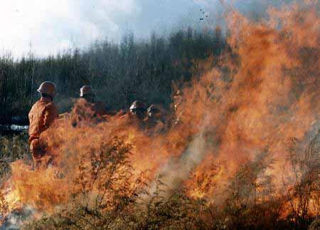
41 Citrus leaf yellow and rolling in Huichang county,ganzhou,jiangxi Province
42 Assess on cotton. High temperature and severe drought made cottonseed diminishing and seeds weight decreasing, which cause that yield decrease 50% to normal year.
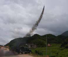
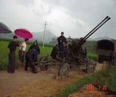
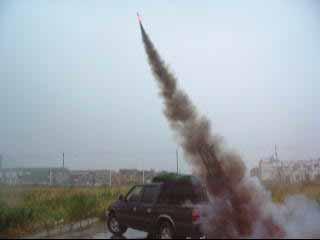
43 Assess on vegetable. Growth and developing of vegetable were embarrassed, which caused flower failing and yield decreasing obviously. High temperature and strong sunlight made leaf dehydrating. Some vegetable appeared dry and death when irrigation condition is not sufficient. Yield and quality were influenced.

44 Bean dry rot

45 White gourd dry rot
46 4.3 Assess on forestry High temperature and severe drought cause high frequency of forest pests and diseases,which led bamboo locust to occur a nd spread.

47 Number of days with high risk of forest fire grade from July in 2003 to February in 2004.
48 Frequency of forest fire happened. For example, Monitoring from remote sensing, there were fifteen times forest fire occurred on in July,2003,Jiangxi.
49 Forest fire,jiujiang,july,2003
50 5. Some measures to fight drought Meteorological department in Jiangxi province provide large amount service information to government and producers such as high temperature and drought monitoring, warning, forecasting and evaluating. Large scale of artificial weather modification were carried to fight drought, decreased fire risk grade, and exterminated forest fire.
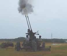
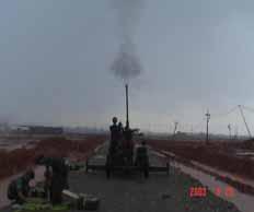
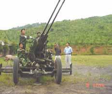
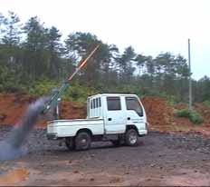
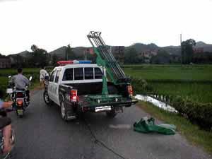
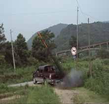
51 Artificial Weather Modification
52 6. Discussion The assessment techniques on this extreme disaster are not sufficient to satisfy service. Methods to monitor and predict abnormal high temperature and drought are not objective and quantitative. Practical techniques to abate the extremely disasters are not sufficient.
53 Reference 1.Yixianwang, Influence of Height on in Penman Formula. Meteorological Journal, (4) OuyangHai, Hongliang-Tong, Xuhui-Li, Study on Evaportranspiration in China. Corpus on Dro ught, Publishing Company of Meteorology,Beijing,p42 52, OuyangHai, etc., Agroclimatology. Publishing Company of Meteorology,Beijing,p3 p , Xiaorui-Wangetc., Statistics Methods to Calculate Evaportranspiration and Application on Diagn osing Drought and Flood. Atmosphere Research and Application,p Hong-Tian etc., Study on Drought Dynamic Assessment Index in Sichuan. Meteorology, 24 (4) 11 15, Guodong-Gao, Yurong-Lu, Agroclimatology, Publishing Company of Meteorology, Beijing, p11, 1-50, Xianqun-Xie,Dakang-Zuo,Dengyen-Tang.Farmland Evaportranspiration---Observing and calcul ate. Publishing Company of Meteorology, Beijing, p , Zixi-Zhu,Study on Agriculture Meteorology and Field Evaportranspiration.Meteorology, 22 4, p3 9, 1996.
54 For your attention
The Study of Dynamic Monitor of Rice Drought in Jiangxi Province with Remote Sensing
 Available online at www.sciencedirect.com Procedia Environmental Sciences 10 (2011 ) 1847 1853 2011 3rd International Conference on Environmental Science and Information Conference Application Title Technology
Workshop on Drought and Extreme Temperatures: Preparedness and Management for Sustainable Agriculture, Forestry and Fishery
 Workshop on Drought and Extreme Temperatures: Preparedness and Management for Sustainable Agriculture, Forestry and Fishery 16-17 Feb.2009, Beijing, China Modeling Apple Tree Bud burst time and frost risk
2002 Drought History in Colorado A Brief Summary
 1 2002 Drought History in Colorado A Brief Summary Colorado Climate Center Roger Pielke, Sr, Director and Nolan Doesken, Research Associate Prepared by Odie Bliss & Tara Green http://climate.atmos.colostate.edu
Analytical Report. Drought in Sri Lanka January2017 ERCC Analytical Team and JRC Drought Team 26 January Map
 1. Map 2. Situation analysis Sri Lanka 1 is currently experiencing a severe drought. This drought situation has been caused by a severe lack of rainfall during the last second Inter-monsoon season (IM2)
The study of the impact of climate variability on Aman rice yield of Bangladesh
 The study of the impact of climate variability on Aman rice yield of Bangladesh Toma Rani Saha 1 and Dewan Abdul Quadir 2 Abstract An attempt has been made to investigate the relationship of climate variability
Indices and Indicators for Drought Early Warning
 Indices and Indicators for Drought Early Warning ADRIAN TROTMAN CHIEF, APPLIED METEOROLOGY AND CLIMATOLOGY CARIBBEAN INSTITUTE FOR METEOROLOGY AND HYDROLOGY IN COLLABORATION WITH THE NATIONAL DROUGHT MITIGATION
NIDIS Intermountain West Drought Early Warning System August 8, 2017
 NIDIS Drought and Water Assessment 8/8/17, 4:43 PM NIDIS Intermountain West Drought Early Warning System August 8, 2017 Precipitation The images above use daily precipitation statistics from NWS COOP,
Emerging Needs, Challenges and Response Strategy
 Emerging Needs, Challenges and Response Strategy Development of Integrated Observing Systems in China JIAO Meiyan Deputy Administrator China Meteorological Administration September 2011 Geneva Outline
The Colorado Drought : 2003: A Growing Concern. Roger Pielke, Sr. Colorado Climate Center.
 The Colorado Drought 2001-2003: 2003: A Growing Concern Roger Pielke, Sr. Colorado Climate Center Prepared by Tara Green and Odie Bliss http://climate.atmos.colostate.edu 2 2002 Drought History in Colorado
NATIONAL HYDROPOWER ASSOCIATION MEETING. December 3, 2008 Birmingham Alabama. Roger McNeil Service Hydrologist NWS Birmingham Alabama
 NATIONAL HYDROPOWER ASSOCIATION MEETING December 3, 2008 Birmingham Alabama Roger McNeil Service Hydrologist NWS Birmingham Alabama There are three commonly described types of Drought: Meteorological drought
Analysis of meteorological measurements made over three rainy seasons in Sinazongwe District, Zambia.
 Analysis of meteorological measurements made over three rainy seasons in Sinazongwe District, Zambia. 1 Hiromitsu Kanno, 2 Hiroyuki Shimono, 3 Takeshi Sakurai, and 4 Taro Yamauchi 1 National Agricultural
Precipitation. Standardized Precipitation Index. NIDIS Intermountain West Drought Early Warning System September 5, 2017
 9/6/2017 NIDIS Drought and Water Assessment NIDIS Intermountain West Drought Early Warning System September 5, 2017 Precipitation The images above use daily precipitation statistics from NWS COOP, CoCoRaHS,
TUNDRA. Column 1 biome name Column 2 biome description Column 3 examples of plant adaptations
 Biome Cards (pp. 1 of 7) Cut out each biome card and divide each card into three sections. Place all sections in a plastic storage bag. Have one bag for every two students. Column 1 biome name Column 2
Impact on Agriculture
 Weather Variability and the Impact on Agriculture InfoAg 2017 Copyright 2017, awhere. All Rights Reserved The Problem: The Earth s Atmosphere is a Heat Engine In transition 1 C warming of atmosphere Triples
2006 Drought in the Netherlands (20 July 2006)
") 2006 Drought in the Netherlands (20 July 2006) Henny A.J. van Lanen, Wageningen University, the Netherlands (henny.vanlanen@wur.nl) The Netherlands is suffering from tropical heat and it is facing a meteorological
2006 Drought in the Netherlands (20 July 2006) Henny A.J. van Lanen, Wageningen University, the Netherlands (henny.vanlanen@wur.nl) The Netherlands is suffering from tropical heat and it is facing a meteorological
Joint Meeting of RA II WIGOS Project and RA V TT-SU on 11 October 2018 BMKG Headquarter Jakarta, Indonesia. Mrs. Sinthaly CHANTHANA
 Joint Meeting of RA II WIGOS Project and RA V TT-SU on 11 October 2018 BMKG Headquarter Jakarta, Indonesia Mrs. Sinthaly CHANTHANA Lao PDR Background Department of Meteorology and Hydrology ( DMH ) in
DROUGHT ASSESSMENT USING SATELLITE DERIVED METEOROLOGICAL PARAMETERS AND NDVI IN POTOHAR REGION
 DROUGHT ASSESSMENT USING SATELLITE DERIVED METEOROLOGICAL PARAMETERS AND NDVI IN POTOHAR REGION Researcher: Saad-ul-Haque Supervisor: Dr. Badar Ghauri Department of RS & GISc Institute of Space Technology
DROUGHT IN MAINLAND PORTUGAL
 DROUGHT IN MAINLAND Ministério da Ciência, Tecnologia e Ensino Superior Instituto de Meteorologia, I. P. Rua C Aeroporto de Lisboa Tel.: (351) 21 844 7000 e-mail:informacoes@meteo.pt 1749-077 Lisboa Portugal
Anticipated and Observed Trends in the Global Hydrological Cycle. Kevin E. Trenberth NCAR
 Anticipated and Observed Trends in the Global Hydrological Cycle Kevin E. Trenberth NCAR The presence of moisture affects the disposition of incoming solar radiation: Evaporation (drying) versus temperature
Analytical Report. Drought in the Horn of Africa February Executive summary. Geographical context. Likelihood of drought impact (LDI)
") Executive summary The current drought in the Horn of Africa is affecting especially Somalia, among other countries, in particular the central and southern regions, where most population is located. Overall,
Executive summary The current drought in the Horn of Africa is affecting especially Somalia, among other countries, in particular the central and southern regions, where most population is located. Overall,
Monthly overview. Rainfall
 Monthly overview 1 to 10 April 2018 Widespread rainfall continued to fall over most parts of the summer rainfall region during this period. Unseasonably good rain fell over the eastern half of the Northern
Fire Weather Drivers, Seasonal Outlook and Climate Change. Steven McGibbony, Severe Weather Manager Victoria Region Friday 9 October 2015
 Fire Weather Drivers, Seasonal Outlook and Climate Change Steven McGibbony, Severe Weather Manager Victoria Region Friday 9 October 2015 Outline Weather and Fire Risk Environmental conditions leading to
Ganbat.B, Agro meteorology Section
 NATIONAL AGENCY FOR METEOROLOGY, HYDROLOGY AND ENVIRONMENT MONITORING OF MONGOLIA Ganbat.B, Agro meteorology Section OF INSTITUTE OF METEOROLOGY AND HYDROLOGY 2009 YEAR Location Climate Northern Asia,
NIDIS Intermountain West Drought Early Warning System September 4, 2018
 NIDIS Drought and Water Assessment NIDIS Intermountain West Drought Early Warning System September 4, 2018 Precipitation The images above use daily precipitation statistics from NWS COOP, CoCoRaHS, and
The agroclimatic resource change in Mongolia
 The agroclimatic resource change in Mongolia Azzaya D, Gantsetseg B, Munkhzul D Institute of Meteorology and Hydrology,Juulchny gudamj-5, Ulaanbaatar-46, Mongolia, 210646, meteoins@magicnet.mn, azzaya23@yahoo.com
Lecture 24 Plant Ecology
 Lecture 24 Plant Ecology Understanding the spatial pattern of plant diversity Ecology: interaction of organisms with their physical environment and with one another 1 Such interactions occur on multiple
Water Supply Conditions and Outlook October 1, 2018
 Water Supply Conditions and Outlook October 1, 2018 Flow Forecasting & Operations Planning Water Security Agency Overview Water supply conditions across Saskatchewan remain near normal, with most reservoirs
NIDIS Intermountain West Drought Early Warning System November 21, 2017
 NIDIS Drought and Water Assessment NIDIS Intermountain West Drought Early Warning System November 21, 2017 Precipitation The images above use daily precipitation statistics from NWS COOP, CoCoRaHS, and
POTENTIAL EVAPOTRANSPIRATION AND DRYNESS / DROUGHT PHENOMENA IN COVURLUI FIELD AND BRATEŞ FLOODPLAIN
 PRESENT ENVIRONMENT AND SUSTAINABLE DEVELOPMENT, VOL. 5, no.2, 2011 POTENTIAL EVAPOTRANSPIRATION AND DRYNESS / DROUGHT PHENOMENA IN COVURLUI FIELD AND BRATEŞ FLOODPLAIN Gigliola Elena Ureche (Dobrin) 1
OVERVIEW OF IMPROVED USE OF RS INDICATORS AT INAM. Domingos Mosquito Patricio
 OVERVIEW OF IMPROVED USE OF RS INDICATORS AT INAM Domingos Mosquito Patricio domingos.mosquito@gmail.com Introduction to Mozambique /INAM Introduction to AGRICAB/SPIRITS Objectives Material & Methods Results
Analysis on Characteristics of Precipitation Change from 1957 to 2015 in Weishan County
 Journal of Geoscience and Environment Protection, 2017, 5, 125-133 http://www.scirp.org/journal/gep ISSN Online: 2327-4344 ISSN Print: 2327-4336 Analysis on Characteristics of Precipitation Change from
Table 1. August average temperatures and departures from normal ( F) for selected cities.
 for selected cities.") Climate Summary for Florida August 2016 Prepared by Lydia Stefanova and David Zierden Florida Climate Center, The Florida State University, Tallahassee, Florida Online at: http://climatecenter.fsu.edu/products-services/summaries
Climate Summary for Florida August 2016 Prepared by Lydia Stefanova and David Zierden Florida Climate Center, The Florida State University, Tallahassee, Florida Online at: http://climatecenter.fsu.edu/products-services/summaries
Fukien Secondary School Monthly Vocabulary/Expression List for EMI Subjects Secondary Two. Subject: Geography
 Focus: General Specific : Section Two : Unit One 1 Landslide 2 Downslope movement 3 Rock 4 Soil 5 Gravity 6 Natural hazard 7 Rainwater 8 Friction 9 Hilly relief 10 Unstable 11 Season 12 Saturated 13 Construction
An introduction to drought indices
 An introduction to drought indices WMO-ETSCI Workshop, Barbados 17 February 2015 Acacia Pepler Australian Bureau of Meteorology "Drought" by Tomas Castelazo - Own work. Licensed under CC BY 3.0 via Commons
CONTENTS. Foreword... Summary (English, French, Russian, Spanish) 1. Introduction by R. Schneider
 1. Introduction by R. Schneider") CONTENTS Page Foreword............ IX Summary (English, French, Russian, Spanish) XI 1. Introduction by R. Schneider.. 1 1.1 1.1.1 1.1.2 1.1.3 1.1.4 1.1.5 1.1.6 1.2 1.2.1 1.2.2 1.2.3 The present position
CONTENTS Page Foreword............ IX Summary (English, French, Russian, Spanish) XI 1. Introduction by R. Schneider.. 1 1.1 1.1.1 1.1.2 1.1.3 1.1.4 1.1.5 1.1.6 1.2 1.2.1 1.2.2 1.2.3 The present position
Monthly overview. Rainfall
 Monthly overview 1-10 August 2018 The month started off with light showers over the Western Cape. A large cold front made landfall around the 5th of the month. This front was responsible for good rainfall
Extremes Events in Climate Change Projections Jana Sillmann
 Extremes Events in Climate Change Projections Jana Sillmann Max Planck Institute for Meteorology International Max Planck Research School on Earth System Modeling Temperature distribution IPCC (2001) Outline
Northwest Outlook September 2017
 Northwest Outlook September 2017 Hot and dry August August 2017 continued with the pattern established in June and July that featured a large, semipermanent ridge in the flow of the jet stream. Temperatures
NIDIS Intermountain West Drought Early Warning System July 18, 2017
 NIDIS Drought and Water Assessment NIDIS Intermountain West Drought Early Warning System July 18, 2017 Precipitation The images above use daily precipitation statistics from NWS COOP, CoCoRaHS, and CoAgMet
Moisture Situation Update November 6, 2016
 Synopsis October 2016, was unseasonably cool and wet across most of the province. This was particularly true for lands north of the Yellowhead Highway, as well as many other areas, west of Highway 2, stretching
Study of Hydrometeorology in a Hard Rock Terrain, Kadirischist Belt Area, Anantapur District, Andhra Pradesh
 Open Journal of Geology, 2012, 2, 294-300 http://dx.doi.org/10.4236/ojg.2012.24028 Published Online October 2012 (http://www.scirp.org/journal/ojg) Study of Hydrometeorology in a Hard Rock Terrain, Kadirischist
EXTRACTION OF REMOTE SENSING INFORMATION OF BANANA UNDER SUPPORT OF 3S TECHNOLOGY IN GUANGXI PROVINCE
 EXTRACTION OF REMOTE SENSING INFORMATION OF BANANA UNDER SUPPORT OF 3S TECHNOLOGY IN GUANGXI PROVINCE Xin Yang 1,2,*, Han Sun 1, 2, Zongkun Tan 1, 2, Meihua Ding 1, 2 1 Remote Sensing Application and Test
Monthly Overview. Rainfall
 Monthly Overview Rainfall during August occurred mainly over the Western and Eastern Cape provinces, and KwaZulu- Natal. Rain in these provinces were regularly accompanied by cold fronts as they made landfall
DROUGHT MONITORING BULLETIN
 DROUGHT MONITORING BULLETIN 24 th November 2014 Hot Spot Standardized Precipitation Index for time period from November 2013 to April 2014 was, due to the lack of precipitation for months, in major part
NIDIS Intermountain West Regional Drought Early Warning System February 7, 2017
 NIDIS Drought and Water Assessment NIDIS Intermountain West Regional Drought Early Warning System February 7, 2017 Precipitation The images above use daily precipitation statistics from NWS COOP, CoCoRaHS,
Vermont Soil Climate Analysis Network (SCAN) sites at Lye Brook and Mount Mansfield
 sites at Lye Brook and Mount Mansfield") Vermont Soil Climate Analysis Network (SCAN) sites at Lye Brook and Mount Mansfield 13 Years of Soil Temperature and Soil Moisture Data Collection September 2000 September 2013 Soil Climate Analysis Network
Vermont Soil Climate Analysis Network (SCAN) sites at Lye Brook and Mount Mansfield 13 Years of Soil Temperature and Soil Moisture Data Collection September 2000 September 2013 Soil Climate Analysis Network
SEASONAL CLIMATE OUTLOOK VALID FOR JULY-AUGUST- SEPTEMBER 2013 IN WEST AFRICA, CHAD AND CAMEROON
 SEASONAL CLIMATE OUTLOOK VALID FOR JULY-AUGUST- SEPTEMBER 2013 IN WEST AFRICA, CHAD AND CAMEROON May 29, 2013 ABUJA-Federal Republic of Nigeria 1 EXECUTIVE SUMMARY Given the current Sea Surface and sub-surface
Climate Indices and Indicators for Agriculture
 Climate Indices and Indicators for Agriculture ADRIAN TROTMAN CHIEF, A PPLIED M ETEOROLOGY A ND CLIMATOLOGY CARIBBEAN INSTITUTE FOR METEOROLOGY AND HYDROLOGY WMO WORKSHOP ON ENHANCING CLIMATE INDICES FOR
Water Supply Conditions and Outlook June 4, 2018
 Water Supply Conditions and Outlook June 4, 2018 Flow Forecasting & Operations Planning Water Security Agency Overview Water supply conditions across Saskatchewan are generally good with most reservoir
Geostatistical Analysis of Rainfall Temperature and Evaporation Data of Owerri for Ten Years
 Atmospheric and Climate Sciences, 2012, 2, 196-205 http://dx.doi.org/10.4236/acs.2012.22020 Published Online April 2012 (http://www.scirp.org/journal/acs) Geostatistical Analysis of Rainfall Temperature
FOREST FIRE HAZARD MODEL DEFINITION FOR LOCAL LAND USE (TUSCANY REGION)
") FOREST FIRE HAZARD MODEL DEFINITION FOR LOCAL LAND USE (TUSCANY REGION) C. Conese 3, L. Bonora 1, M. Romani 1, E. Checcacci 1 and E. Tesi 2 1 National Research Council - Institute of Biometeorology (CNR-
FOREST FIRE HAZARD MODEL DEFINITION FOR LOCAL LAND USE (TUSCANY REGION) C. Conese 3, L. Bonora 1, M. Romani 1, E. Checcacci 1 and E. Tesi 2 1 National Research Council - Institute of Biometeorology (CNR-
AgWeatherNet A Tool for Making Decisions Based on Weather
 AgWeatherNet A Tool for Making Decisions Based on Weather Gerrit Hoogenboom Director, AgWeatherNet & Professor of Agrometeorology Washington State University Prosser, Washington November 14, 2013 Washington
Energy Efficiency Review
 Energy Efficiency Review Efficiency refers to the ability of an energy conversion reaction to convert energy from one form to the next without losing too much heat to the environment (electrical to light,
GEOG415 Mid-term Exam 110 minute February 27, 2003
 GEOG415 Mid-term Exam 110 minute February 27, 2003 1 Name: ID: 1. The graph shows the relationship between air temperature and saturation vapor pressure. (a) Estimate the relative humidity of an air parcel
MODELLING FROST RISK IN APPLE TREE, IRAN. Mohammad Rahimi
 WMO Regional Seminar on strategic Capacity Development of National Meteorological and Hydrological Services in RA II (Opportunity and Challenges in 21th century) Tashkent, Uzbekistan, 3-4 December 2008
Climates of Earth. Lesson Outline LESSON 1. A. What is climate? 1. is the long-term average weather conditions that occur in a particular region.
 Lesson Outline LESSON 1 A. What is climate? 1. is the long-term average weather conditions that occur in a particular region. 2. Climate depends on how average weather conditions throughout the year. B.
Drought Criteria. Richard J. Heggen Department of Civil Engineering University of New Mexico, USA Abstract
 Drought Criteria Richard J. Heggen Department of Civil Engineering University of New Mexico, USA rheggen@unm.edu Abstract Rainwater catchment is an anticipatory response to drought. Catchment design requires
Range Cattle Research and Education Center January CLIMATOLOGICAL REPORT 2016 Range Cattle Research and Education Center.
 1 Range Cattle Research and Education Center January 2017 Research Report RC-2017-1 CLIMATOLOGICAL REPORT 2016 Range Cattle Research and Education Center Brent Sellers Weather conditions strongly influence
Current Climate Trends and Implications
 Current Climate Trends and Implications Dr. Mark Seeley Professor emeritus Department of Soil, Water, and Climate University of Minnesota St Paul, MN 55108 Crop Insurance Conference September 12, 2018
Climate also has a large influence on how local ecosystems have evolved and how we interact with them.
 The Mississippi River in a Changing Climate By Paul Lehman, P.Eng., General Manager Mississippi Valley Conservation (This article originally appeared in the Mississippi Lakes Association s 212 Mississippi
An ENSO-Neutral Winter
 An ENSO-Neutral Winter This issue of the Blue Water Outlook newsletter is devoted towards my thoughts on the long range outlook for winter. You will see that I take a comprehensive approach to this outlook
NIDIS Intermountain West Drought Early Warning System October 17, 2017
 NIDIS Drought and Water Assessment NIDIS Intermountain West Drought Early Warning System October 17, 2017 Precipitation The images above use daily precipitation statistics from NWS COOP, CoCoRaHS, and
Development of Agrometeorological Models for Estimation of Cotton Yield
 DOI: 10.5958/2349-4433.2015.00006.9 Development of Agrometeorological Models for Estimation of Cotton Yield K K Gill and Kavita Bhatt School of Climate Change and Agricultural Meteorology Punjab Agricultural
2007: The Netherlands in a drought again (2 May 2007)
") 2007: The Netherlands in a drought again (2 May 2007) Henny A.J. van Lanen, Wageningen University, the Netherlands (henny.vanlanen@wur.nl) Like in June and July 2006, the Netherlands is again facing a
2007: The Netherlands in a drought again (2 May 2007) Henny A.J. van Lanen, Wageningen University, the Netherlands (henny.vanlanen@wur.nl) Like in June and July 2006, the Netherlands is again facing a
Precipitation. Standardized Precipitation Index. NIDIS Intermountain West Regional Drought Early Warning System January 3, 2017
 1/3/2017 NIDIS Drought and Water Assessment NIDIS Intermountain West Regional Drought Early Warning System January 3, 2017 Precipitation The images above use daily precipitation statistics from NWS COOP,
Soil moisture retrieval with remote sensing images for debris flow forecast in humid regions
 Monitoring, Simulation, Prevention and Remediation of Dense and Debris Flows III 89 Soil moisture retrieval with remote sensing images for debris flow forecast in humid regions Y. Zhao 1,2,3, H. Yang 1,2
Meteorology. Chapter 15 Worksheet 1
 Chapter 15 Worksheet 1 Meteorology Name: Circle the letter that corresponds to the correct answer 1) The Tropic of Cancer and the Arctic Circle are examples of locations determined by: a) measuring systems.
The Pennsylvania Observer
 The Pennsylvania Observer May 31, 2012 May 2012 - Pennsylvania Weather Recap By: Paul Knight The majority of the fifth month had temperatures averaging well above seasonal levels with two distinct hot
Meteorological Information for Locust Monitoring and Control. Robert Stefanski. Agricultural Meteorology Division World Meteorological Organization
 Meteorological Information for Locust Monitoring and Control Robert Stefanski Agricultural Meteorology Division World Meteorological Organization Objectives of Workshop Presentation Meteorological requirements
Summary and Conclusions
 241 Chapter 10 Summary and Conclusions Kerala is situated in the southern tip of India between 8 15 N and 12 50 N latitude and 74 50 E and 77 30 E longitude. It is popularly known as Gods own country.
Multiple Choice Identify the choice that best completes the statement or answers the question.
 CH.15 practice TEST Multiple Choice Identify the choice that best completes the statement or answers the question. 1) The short-term state of the atmosphere is called a) climate. c) water cycle. b) weather.
Recent development of the National Hydro-Meteorological Service (NHMS) of Viet Nam for disaster risk reduction
 of Viet Nam for disaster risk reduction") Ministry of Natural Resources and Environment National Hydro-Meteorological Service Recent development of the National Hydro-Meteorological Service (NHMS) of Viet Nam for disaster risk reduction Tran Van
Ministry of Natural Resources and Environment National Hydro-Meteorological Service Recent development of the National Hydro-Meteorological Service (NHMS) of Viet Nam for disaster risk reduction Tran Van
Crop and pasture monitoring in Eritrea
 JRC SCIENTIFIC AND POLICY REPORTS Crop and pasture monitoring in Eritrea Kremti rainy season started with substantial delay Ana Pérez-Hoyos, Francois Kayitakire, Hervé Kerdiles, Felix Rembold, Olivier
2016 Fall Conditions Report
 2016 Fall Conditions Report Prepared by: Hydrologic Forecast Centre Date: December 13, 2016 Table of Contents TABLE OF FIGURES... ii EXECUTIVE SUMMARY... 1 BACKGROUND... 5 SUMMER AND FALL PRECIPITATION...
GIS-BASED DISASTER WARNING SYSTEM OF LOW TEMPERATURE AND SPARE SUNLIGHT IN GREENHOUSE
 GIS-BASED DISASTER WARNING SYSTEM OF LOW TEMPERATURE AND SPARE SUNLIGHT IN GREENHOUSE 1,2,* 1,2 Ruijiang Wei, Chunqiang Li, Xin Wang 1, 2 1 Hebei Provincial Institute of Meteorology, Shijiazhuang, Hebei
Rong Jiang. Map of River. Table of Basic Data. China 14. Serial No. : China-14
 Rong Jiang Map of River Table of Basic Data Name(s): Rong Jiang Location: Guangdong Province, Coastways China Area: 4,408 km 2 Serial No. : China-14 N 23 11' ~ 23 55' E 115 37' ~ 116 38' Length of the
Meteorological alert system in NMS of Mongolia
 Meteorological alert system in NMS of Mongolia L.Oyunjargal, NAMEM Regional Workshop on Impact-based Forecasts in Asia Seoul, Korea, 07-09 NOV 2017 Weather related disasters 1. Strong wind and snow and
JRC MARS Bulletin global outlook 2017 Crop monitoring European neighbourhood Turkey June 2017
 MARS Bulletin global outlook 2015-06 r JRC MARS Bulletin global outlook 2017 Crop monitoring European neighbourhood Turkey June 2017 Favourable spring conditions, but slight delay Yield forecasts for winter
Fenhe (Fen He) Map of River. Table of Basic Data. China 10
 Map of River. Table of Basic Data. China 10") Fenhe (Fen He) Map of River Table of Basic Data Name(s): Fenhe (in Huanghe River) Location: Shanxi Province, Northern China Area: 39,471 km 2 Origin: Mt. Guancen (2,147 m) Outlet: Huanghe Serial No. :
Fenhe (Fen He) Map of River Table of Basic Data Name(s): Fenhe (in Huanghe River) Location: Shanxi Province, Northern China Area: 39,471 km 2 Origin: Mt. Guancen (2,147 m) Outlet: Huanghe Serial No. :
November 2018 Weather Summary West Central Research and Outreach Center Morris, MN
 November 2018 Weather Summary Lower than normal temperatures occurred for the second month. The mean temperature for November was 22.7 F, which is 7.2 F below the average of 29.9 F (1886-2017). This November
NIDIS Intermountain West Drought Early Warning System November 14, 2017
 NIDIS Intermountain West Drought Early Warning System November 14, 2017 Precipitation The images above use daily precipitation statistics from NWS COOP, CoCoRaHS, and CoAgMet stations. From top to bottom,
2003 Moisture Outlook
 2003 Moisture Outlook Nolan Doesken and Roger Pielke, Sr. Colorado Climate Center Prepared by Tara Green and Odie Bliss http://climate.atmos.colostate.edu Through 1999 Through 1999 Fort Collins Total Water
THE STUDY OF NUMBERS AND INTENSITY OF TROPICAL CYCLONE MOVING TOWARD THE UPPER PART OF THAILAND
 THE STUDY OF NUMBERS AND INTENSITY OF TROPICAL CYCLONE MOVING TOWARD THE UPPER PART OF THAILAND Aphantree Yuttaphan 1, Sombat Chuenchooklin 2 and Somchai Baimoung 3 ABSTRACT The upper part of Thailand
Climate Change and Biomes
 Climate Change and Biomes Key Concepts: Greenhouse Gas WHAT YOU WILL LEARN Biome Climate zone Greenhouse gases 1. You will learn the difference between weather and climate. 2. You will analyze how climate
Range Cattle Research and Education Center January CLIMATOLOGICAL REPORT 2012 Range Cattle Research and Education Center.
 1 Range Cattle Research and Education Center January 2013 Research Report RC-2013-1 CLIMATOLOGICAL REPORT 2012 Range Cattle Research and Education Center Brent Sellers Weather conditions strongly influence
Assimilation of satellite derived soil moisture for weather forecasting
 Assimilation of satellite derived soil moisture for weather forecasting www.cawcr.gov.au Imtiaz Dharssi and Peter Steinle February 2011 SMOS/SMAP workshop, Monash University Summary In preparation of the
National Wildland Significant Fire Potential Outlook
 National Wildland Significant Fire Potential Outlook National Interagency Fire Center Predictive Services Issued: September, 2007 Wildland Fire Outlook September through December 2007 Significant fire
CHAPTER-11 CLIMATE AND RAINFALL
 CHAPTER-11 CLIMATE AND RAINFALL 2.1 Climate Climate in a narrow sense is usually defined as the "average weather", or more rigorously, as the statistical description in terms of the mean and variability
Variability of Reference Evapotranspiration Across Nebraska
 Know how. Know now. EC733 Variability of Reference Evapotranspiration Across Nebraska Suat Irmak, Extension Soil and Water Resources and Irrigation Specialist Kari E. Skaggs, Research Associate, Biological
Rainfall Characteristics Analysis in Landslides Area Based on Micro Rain Radar
 2017 2nd International Conference on Civil Engineering and Rock Engineering (ICCERE 2017) ISBN: 978-1-60595-513-1 Rainfall Characteristics Analysis in Landslides Area Based on Micro Rain Radar Zhiwang
ASSESSMENT OF DIFFERENT WATER STRESS INDICATORS BASED ON EUMETSAT LSA SAF PRODUCTS FOR DROUGHT MONITORING IN EUROPE
 ASSESSMENT OF DIFFERENT WATER STRESS INDICATORS BASED ON EUMETSAT LSA SAF PRODUCTS FOR DROUGHT MONITORING IN EUROPE G. Sepulcre Canto, A. Singleton, J. Vogt European Commission, DG Joint Research Centre,
What is insect forecasting, and why do it
 Insect Forecasting Programs: Objectives, and How to Properly Interpret the Data John Gavloski, Extension Entomologist, Manitoba Agriculture, Food and Rural Initiatives Carman, MB R0G 0J0 Email: jgavloski@gov.mb.ca
but 2012 was dry Most farmers pulled in a crop
 After a winter that wasn t, conditions late in the year pointed to a return to normal snow and cold conditions Most farmers pulled in a crop but 2012 was dry b y M i k e Wr o b l e w s k i, w e a t h e
US Drought Status. Droughts 1/17/2013. Percent land area affected by Drought across US ( ) Dev Niyogi Associate Professor Dept of Agronomy
 Dev Niyogi Associate Professor Dept of Agronomy") Droughts US Drought Status Dev Niyogi Associate Professor Dept of Agronomy Deptof Earth Atmospheric Planetary Sciences Indiana State Climatologist Purdue University LANDSURFACE.ORG iclimate.org climate@purdue.edu
Droughts US Drought Status Dev Niyogi Associate Professor Dept of Agronomy Deptof Earth Atmospheric Planetary Sciences Indiana State Climatologist Purdue University LANDSURFACE.ORG iclimate.org climate@purdue.edu
2011 Year in Review TORNADOES
 2011 Year in Review The year 2011 had weather events that will be remembered for a long time. Two significant tornado outbreaks in April, widespread damage and power outages from Hurricane Irene in August
Chapter 02 Life on Land. Multiple Choice Questions
 Ecology: Concepts and Applications 7th Edition Test Bank Molles Download link all chapters TEST BANK for Ecology: Concepts and Applications 7th Edition by Manuel Molles https://testbankreal.com/download/ecology-concepts-applications-7thedition-test-bank-molles/
Agrometeorological activities in RHMSS
 Republic of Serbia Republic Hydrometeorological Service of Serbia Agrometeorological activities in RHMSS Department for applied climatology and agrometeorology www.hidmet.gov.rs Meteorological Observing
Colorado s 2003 Moisture Outlook
 Colorado s 2003 Moisture Outlook Nolan Doesken and Roger Pielke, Sr. Colorado Climate Center Prepared by Tara Green and Odie Bliss http://climate.atmos.colostate.edu How we got into this drought! Fort
September 2018 Weather Summary West Central Research and Outreach Center Morris, MN
 September 2018 Weather Summary The mean temperature for September was 60.6 F, which is 1.5 F above the average of 59.1 F (1886-2017). The high temperature for the month was 94 F on September 16 th. The
The Climate of Payne County
 The Climate of Payne County Payne County is part of the Central Great Plains in the west, encompassing some of the best agricultural land in Oklahoma. Payne County is also part of the Crosstimbers in the