Early Warning System for Tornado. Japan. Osamu Suzuki Meteorological Research Institute
|
|
|
- Roger Higgins
- 6 years ago
- Views:
Transcription
1 International Forum on Tornado Disaster Risk Reduction for Bangladesh - To Cope with Neglected Severe Disasters December 2009, Dhaka, Bangladesh Early Warning System for Tornado and other hazardous winds in Japan Osamu Suzuki Meteorological Research Institute Japan Meteorological Agency Photo:Saroma tornado, 7 November 2006, Courtesy of Ms. Takai
2 Two tornadoes in 2006


3 Nobeoka, Miyazaki Tornado on 17 September 2006, F2 3 fatalities and 143 injuries Typhoon assosiated mini- supercell tornado Damage path length 7.5km and width 300 m.


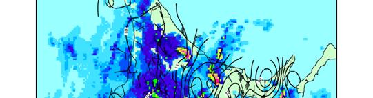


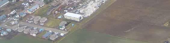

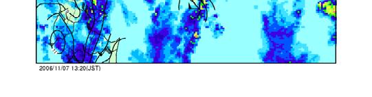


4 Saroma, Hokkaido tornado on 7 November 2006, F3 9 fatalities and 26 injuries Largest fatalities since 1942 Possible supercell tornado 1320JST Radar (color) and Surface pressure (color line, 1 hpa) Temperature (black line, 1 deg)
5 Short lecture on Tornadoes in Japan
6 Annual frequency of Tornadoes 13 7 /yr 13.7 / yr ( )
7 Death and Injuries by Tornadoes and other hazardous winds Event Number of Average peoples per year Fatalities Tornadoes Tornadoes and other hazardous winds Injuries Tornadoes Tornadoes and other h d i d hazardous winds ( ) Fatalities and injuries by tornadoes are 12 and 193, respectively in 2005 and Fatalities and injuries by all the events are 17 and247, respectively in the same period.
8 Geographical distribution and damage path size of Tornadoes A significant numb of tornadoes occur near Average of damage path width is 260m. the coastlines. Inland tornadoes occur And average of damage path length is 3.2 mainly in large plains km but longest track was 42 km length. Damage path width ditribution 140 Numb ber mean stdev mode ~16 16~51 51~ ~ ~ ~ width (m) Damage path length ditribution 140 Number mean stdev mode ~ ~ ~ ~ ~ ~ Length (km)
9 Fujita-scale Fujita scale of events ( ) ( ) No tornado severe than F3. Reported F0 and F1 tornado increased. Number F-scale
10 Supercell Tornado Supercell An often dangerous convective storm that consists primarily of a single, quasi-steady rotating updraft. It may exist for several hours and usually forms in an environment with strong vertical wind shear. (from AMS glossary of meteorology) Rotating updraft in a supercell is called mesocyclone. Identified supercells in JAPAN (not all) 1978/2/28 Tornado (F2-3) Derailed (Low) 1990/9/19 Mibu tornado (F2) (Typhoon, mini) 1990/12/11 Mobra tornado (F3) (Low) 1996/7/5/ Chiba tornado (F2) (Low, mini) i) 1996/7/15 Hail storm with downburst (F2) in Ibaraki 1999/9/24 Toyohashi forward (F3) (Typhoon, mini) 2000/5/24 Hail storm with downburst in Chiba and Ibaraki 2001/5/11 Hail storm with strong ggust in Chiba and Ibaraki 2001/8/22 Tornado (F1) in Saitama, straight line wind in Gumma 2001/9/10 Tornado in Tokyo (F1) (Typhoon ) 2002/7/10 Sakai-town tornado (F2) (Typhoon, mini) 2004/9/30 Tornado at Haneda airport (F1-2)(Typhoon) 2005/5/15 Straight line winds in Tokyo and Kanagawa (F0-1) 2005/6/4 Downburst at Ohsaka airport 2006/7/5 Tornado in Kochi (F0-1) 2006/9/17 Nobeoka tornado (F2) (Typhoon, mini) 2007/3/15 Tornado in Okinawa (F1) Schematic illustration of a supercell. Lemon and Doswell, 1979


11 First Doppler-radar-identified supercell in Japan Mobara tornado (F3) on December 11, 1990 Mesocyclone signature is detected in Doppler velocity field. from Suzuki and Niino, 1991 Mesocyclone movement. from Niino et al., 1993
12 Mini-supercells on Sept. 19, 1990 mini-supercell Convective storm that contains similar radar characteristics to those of a supercell (e.g., hook echo, WER, BWER), but is significantly smaller in height and width. (from AMS Glossary of Meteorology) The PPI display of reflectivity (a) and Doppler velocity (b) of storms E, F, and G with elevation angle of 2.2 deg at 2146 JST. The RHI display of reflectivity (c) and Doppler velocity (d) of storm G with azimuth angle 250 deg at 2153 JST. The MCs are indicated by open circles in the PPI displays. Arrows in (d) indicate wind directions relative the radar deduced from the Doppler velocity field. from Suzuki et al., 2000


13 Mini-supercells and tornadoes on Sept. 19, 1990 A 2012 B D Inagi City C E F G TOKYO H Mibu Town MRI I N Shimotsuma Chiyokawa Azuma Village Pacific 2112 Ocean 20 km 9 identified mini-supercells were idenfied. 3 mini-supercells out of 9 spawned tornadoes and one caused wind damage within 6 hours. Movement of mesocyclones and storms detected by the MRI Doppler radar on the night of 19 September The solid triangles connected by thin lines show the locations of mesocyclones. Numerals by the triangles indicate the beginning g or end time of the detection of mesocyclones. Mesocyclone paths in the same storms are connected with dashed lines. Thick lines and solid circles show the location of damages by tornadoes (Inagi City, Mibu Town, and Azuma village) and heavy winds (Chiyokawa and Shimotsuma), respectively. from Suzuki et al., 2000 This fact indicated possibilities of tornado warning using Doppler radar as in US.
14 Non-Supercell Tornado A tornado that occurs with a parent cloud in its growth stage and with its vorticity originating in the boundary layer. The parent cloud does not contain a preexisting midlevel mesocyclone. (from AMS glossary of meteorology) from Wakimoto and Wilson, 1989
15 Building an Early Warning System for Tornadoes and other hazardous winds
16 JMA's Action JMA decided to build an early warning system for tornadoes and other hazardous winds. Speed up upgrade plan for existing conventional radar to Doppler Re-construct tornado database (not shown) Develop a techniques for forecasting of tornadoes Develop Mesocyclone detection algorithm Environmental indices calculated from NWP data Set up an advisory committee Disseminate tornado watch Raise Public Awareness
17 Radar network upgrade Doppler Conventional TDWR as as of of 2010/3(planed) 2006/11
18 MC detection algorithm MRI s MC detection algorithm consist of following steps; i) pre-processing Radar data (first QC) ii) fitting observed Doppler velocity fields with wind models iii) checking size, vorticity, i and the fitness of each MC to meet a MC criteria i iv) declearing MC if temporal continuity is satisfied (2nd QC) Wind fields models : RCV+Divergence modified Rankine's combined vortex DIV VOR ( u, v ) = [ ( x, y ) + ( y, x )] s 2 2 L s L s = 1 L if ( r = = r r c 2 x 2 L if ( r > + r c y ) 2 r c ) Vmaxc rc rc rc rc RCV Axsimmetric Divergence Axsymmetirc V+D
19 Examination of algorithm with real data (Example of real data) Sakai town tornadoonjuly on July, 10, 2002 A total of 4 mesocyclones were detected on the day. MC3 MC4 MC1 14:03 15:57 PPI display of Dopler velocities by Narita DRAW (Doppler Radar for Airport Weather) at 1403 JST and 1557 JST on July, 10, Locations of 3 mesocyclones are indicated by black circle. Elev 0.7 deg. max range 120km,
20 Comparison of MCs detected by proposed method with manualy analyzed ones. Compirson with peak-to-peak method - Sakai tornado on July, 10, MC2~4 MC2~4 MC1 Proposed method peak-to-peak method Plots of detected mesocyclones indicate good agreement.
21 Environmental indices for tornado warning CAPE (Convective Available Potential Energy) A measure of instability of the atmosphere. SReH (Storm Relative Helicity)] A measure of vertical wind shear used for evaluating possibility of mesocyclone generation EHI (Energy Helicity Index)(Rasmussen,2003). A measure of supercell/tornado possibility. EHI = CAPE*SReH/ EHI>1 possible supercell, EHI>4 strong tornado Storm motion Note:These indices can be calculated from upper air sounding or NWP data.
22 Example of indices calculated from MSM (NWP) in Japan Time of Nobeoka tornado on September 17, 2006 (mini-supercell) Time of Saroma tornado on November 9, 2006 (possibly supercell)
 = 260 (m^2/s^2) EHI = 5.")
23 Example of indices calculated from upper air sounding at Dhaka on a tornado day Applied to the day of a deadly tornado. Upper air sounding at Dhaka on 13 May, 1996 CAPE = J/kg SReH(estimated) = 260 (m^2/s^2) EHI = 5.4 -> Supercell possible and strong tornados
24 Techniques for forecasting of hazardous winds by the courtesy of Mr. Doi
25 Dissemination of tornado watch by the courtesy of Mr. Doi
26 Tornado Watch (March 2008~)
27 Raising Public Awareness by the courtesy of Mr. Doi
28 How to utilize the Watch? Developing a guideline by the courtesy of Mr. Doi
29 by the courtesy of Mr. Doi Possible Scenario
30 Designing information in collaboration with users Set up an advisory committee composed of professors of meteorology, sociology and risk management, and media people and asked for advice on information contents and how to convey the risk of hazardous winds. Sought opinions from potential users such as construction firms, schools, railway companies. Outcomes from the discussion Name of the information The word tornado should be included, because this word draws people s attention for its risk, while the information of downbursts and gust fronts is also included. Valid time period of the Watch Indication of the valid time period of the Watch (one hour) helps to understand exactly when people should pay attention to severe weather. Support this service The JMA should provide the information, even if the accuracy is rather low; the information can save people s lives when used properly. by the courtesy of Mr. Doi
31 Summary After the deadly tornadoes in 2006, JMA and MRI cooperated to built an Early Warning System for tornado and other hazardous winds. The system is in operation since March Although It is new and under developing, I hope our experience of building an EWS may be useful for other countries like Bangladesh.
32 Thank you for your attentions!
IG-WRDRR, UNESCAP, UNESCO-IOC, WMO. Yukio Tamura Chairman, International. Group. Tuesday 10 May, , Room 13. for Disaster. Risk.
 Side Event: Saving of Lives and Improved Coastal Risk Management through Regional Cooperation in Ocean and Marine Related Early Warning Systems in Asia Tuesday 10 May, 13.15 14.15, Room 13 IG-WRDRR, UNESCAP,
MET Lecture 29 Tornadoes IV
 MET 4300 Lecture 29 Tornadoes IV Outline Definition, life cycle, & climatology of tornadoes Tornado formation within supercells Tornado formation within nonsupercell thunderstorms Fujita scale Tornado
Investigation of Supercells in China : Environmental and Storm Characteristics
 11A.6 Investigation of Supercells in China : Environmental and Storm Characteristics Xiaoding Yu Xiuming Wang Juan Zhao Haiyan Fei ( China Meteorological Administration Training Center) Abstract Based
Tornadoes. tornado: a violently rotating column of air
 Tornadoes tornado: a violently rotating column of air Tornadoes What is the typical size of a tornado? What are typical wind speeds for a tornado? Five-stage life cycle of a tornado Dust Swirl Stage Tornado
scale Observational Systems in Japan Meteorological Agency
 Meso scale scale Observational Systems in Japan Meteorological Agency WWRP Working Group on Mesoscale Weather Forecasting Research March 17, 2008 JMA Headquarters, Tokyo Kenji AKAEDA Observations Division,
Chapter 14 Thunderstorm Fundamentals
 Chapter overview: Thunderstorm appearance Thunderstorm cells and evolution Thunderstorm types and organization o Single cell thunderstorms o Multicell thunderstorms o Orographic thunderstorms o Severe
Solutions to Comprehensive Final Examination Given on Thursday, 13 December 2001
 Name & Signature Dr. Droegemeier Student ID Meteorology 1004 Introduction to Meteorology Fall, 2001 Solutions to Comprehensive Final Examination Given on Thursday, 13 December 2001 BEFORE YOU BEGIN!! Please
Special edition paper
 Research on the Use of Weather Radar in Train Operation Control Wataru Kato* Yoshihiro Hono* On December 25 2005, a derailment occurred near the Daini-Mogamigawa bridge between Sagoshi and Kita-Amarume
Using the Golden Ratio as a Model for Tornadogenesis. George McGivern Brad Walton Dr. Mikhail Shvartsman
 Using the Golden Ratio as a Model for Tornadogenesis George McGivern Brad Walton Dr. Mikhail Shvartsman 1. Introduction: Intro to tornadoes and tornado forecasting. Problem and Goals: The main problems
Journal of the Meteorological Society of Japan, Vol. 74, No. 1, pp , Life Cycle of the Chitose Tornado of September 22, 1988
 Journal of the Meteorological Society of Japan, Vol. 74, No. 1, pp. 125-140, 1996 125 Life Cycle of the Chitose Tornado of September 22, 1988 By Fumiaki Kobayashil, Katsuhiro Kikuchi and Hiroshi Uyeda
Ki-Hong Min 1*, Seonhee Choo 2, and Gyuwon Lee 1, and Kyung-Eak Kim 1,3
 Ki-Hong Min 1*, Seonhee Choo 2, and Gyuwon Lee 1, and Kyung-Eak Kim 1,3 1 School of Earth System Sciences, Major in Atmospheric Science, Kyungpook National University, Daegu, South Korea 2 Forecast Technology
Asymmetry in Wind Field of Typhoon 0115 analyzed by Triple Doppler Radar Observation
 Asymmetry in Wind Field of Typhoon 115 analyzed by Triple Doppler Radar Observation Hiroshi YAMAUCHI*, Osamu SUZUKI (Meteorological Research Institute Kenji AKAEDA (Japan Meteorological Agency 1. Introduction
Pennsylvania Severe Weather of September 2016
 Pennsylvania Severe Weather of September 2016 By Richard H. Grumm National Weather Service State College, PA 1. Overview September 2016 was a relatively quiet month for severe weather across most of the
Chapter 3 Convective Dynamics Part VI. Supercell Storms. Supercell Photos
 Chapter 3 Convective Dynamics Part VI. Supercell Storms Photographs Todd Lindley (This part contains materials taken from UCAR MCS training module) Supercell Photos 1 Introduction A supercel storm is defined
Tornadoes forecasting, dynamics and genesis. Mteor 417 Iowa State University Week 12 Bill Gallus
 Tornadoes forecasting, dynamics and genesis Mteor 417 Iowa State University Week 12 Bill Gallus Tools to diagnose severe weather risks Definition of tornado: A vortex (rapidly rotating column of air) associated
Tornado Occurrences. Tornadoes. Tornado Life Cycle 4/12/17
 Chapter 19 Tornadoes Tornado Violently rotating column of air that extends from the base of a thunderstorm to the ground Tornado Statistics Over (100, 1000, 10000) tornadoes reported in the U.S. every
Severe Thunderstorms. MET 200 Lecture 24 Flooding in Hawaii and Intro to Severe Thunderstorms. MET 200 Lecture 24 Severe Thunderstorms.
 MET 200 Lecture 24 Severe Thunderstorms Damage Swath 1 2 MET 200 Lecture 24 Flooding in Hawaii and Intro to Severe Thunderstorms Severe Thunderstorms Kona Lows Cause more flash floods in Hawaii than any
Module 11: Meteorology Topic 6 Content: Severe Weather Notes
 Severe weather can pose a risk to you and your property. Meteorologists monitor extreme weather to inform the public about dangerous atmospheric conditions. Thunderstorms, hurricanes, and tornadoes are
P4.10. Kenichi Kusunoki 1 * and Wataru Mashiko 1 1. Meteorological Research Institute, Japan
 P4. DOPPLER RADAR INVESTIGATIONS OF THE INNER CORE OF TYPHOON SONGDA (24) Polygonal / elliptical eyewalls, eye contraction, and small-scale spiral bands. Kenichi Kusunoki * and Wataru Mashiko Meteorological
Heavy Rain/Flooding September 8-10 Associated with Tropical Storm Etau
 Heavy Rain/Flooding September 8-10 Associated with Tropical Storm Etau Wx Files Vol.32 September 24, 2015 Tropical Storm Etau made landfall over the Chita Peninsula in Aichi just after 10:00 AM on September
2D Wind Field Estimation with Higher Spatial Resolution Using Dual Compact X-Band Weather Radars
 2D Wind Field Estimation with Higher Spatial Resolution Using Dual Compact X-Band Weather Radars 95th AMS Annual Meeting, Phoenix, Arizona By FURUNO ELECTRIC CO.,LTD January 5th, 2015 Contents 1. Introduction
Meteorology Lecture 19
 Meteorology Lecture 19 Robert Fovell rfovell@albany.edu 1 Important notes These slides show some figures and videos prepared by Robert G. Fovell (RGF) for his Meteorology course, published by The Great
Thunderstorm Downburst Prediction: An Integrated Remote Sensing Approach. Ken Pryor Center for Satellite Applications and Research (NOAA/NESDIS)
") Thunderstorm Downburst Prediction: An Integrated Remote Sensing Approach Ken Pryor Center for Satellite Applications and Research (NOAA/NESDIS) Topics of Discussion Thunderstorm Life Cycle Thunderstorm
Thunderstorm Downburst Prediction: An Integrated Remote Sensing Approach Ken Pryor Center for Satellite Applications and Research (NOAA/NESDIS) Topics of Discussion Thunderstorm Life Cycle Thunderstorm
Type of storm viewed by Spotter A Ordinary, multi-cell thunderstorm. Type of storm viewed by Spotter B Supecell thunderstorm
 ANSWER KEY Part I: Locating Geographical Features 1. The National Weather Service s Storm Prediction Center (www.spc.noaa.gov) has issued a tornado watch on a warm spring day. The watch covers a large
10.2 TORNADIC MINI-SUPERCELLS IN NORTHERN CANADA
 10.2 TORNADIC MINI-SUPERCELLS IN NORTHERN CANADA Patrick J. McCarthy*, Sandra Massey Prairie and Arctic Storm Prediction Centre Meteorological Service of Canada Dave Patrick Hydrometeorological and Arctic
Development of JMA storm surge model
 2 nd JCOMM Scientific and Technical Symposium on Storm Surges 8-13 November 2015, Key West, Florida, USA Development of JMA storm surge model Hiroshi HASEGAWA (h_hasegawa@met.kishou.go.jp) Office of Marine
Supercells. Base lecture and Graphics created by The COMET Program May University Corporation for Atmospheric Research
 Supercells Base lecture and Graphics created by The COMET Program May 2002 University Corporation for Atmospheric Research Objective To be able to forecast and better recognize supercell storms in all
Unit 4. This unit will enable you to improve coordination and communication with State and local agencies when hazardous weather threatens.
 Unit 4 This unit will enable you to improve coordination and communication with State and local agencies when hazardous weather threatens. In this unit we will discuss the role of Emergency Managers in
1A.1 A UNIQUE COLD-SEASON SUPERCELL PRODUCES AN EF1 SNOWNADO
 1A.1 A UNIQUE COLD-SEASON SUPERCELL PRODUCES AN EF1 SNOWNADO David Sills 1*, Marie-Ève Giguère 2, and John Henderson 3 1 Science and Technology Branch, Environment and Climate Change Canada (ECCC), King
Recent Improvement of Integrated Observation Systems in JMA
 Recent Improvement of Integrated Observation Systems in JMA Mr Osamu Suzuki and Mr Yoshihiko Tahara Japan Meteorological Agency 1-3-4 Otemachi, Chiyoda-ku, Tokyo 100-8122, Japan Tel: +81-3-3212-8341, Fax:
FORCES OF NATURE: WEATHER!! TORNADOES. Self-Paced Study
 FORCES OF NATURE: WEATHER!! Self-Paced Study The video clips referenced in this packet can be viewed during class by accessing the T: drive. Go to the folder (Brighton, A. OR Cipriano, H) and click on
Advanced Spotter Training: Anticipating Severe Weather Threats. Professor Paul Sirvatka College of DuPage Meteorology
 Advanced Spotter Training: Anticipating Severe Weather Threats College of DuPage Meteorology Preparing for Severe Weather Preparedness involves understanding the probable and potential threats. Understanding
24 TH CONFERENCE ON SEVERE LOCAL STORMS, OCTOBER 2008, SAVANNAH, GEORGIA
 P9.13 SUPER-RESOLUTION POLARIMETRIC OBSERVATIONS OF A CYCLIC TORNADIC SUPERCELL MATTHEW R. KUMJIAN*, ALEXANDER V. RYZHKOV, AND VALERY M. MELNIKOV Cooperative Institute for Mesoscale Meteorological Studies,
687 Observation of winter lightning in the Shonai area railroad weather project: preliminary results
 687 Observation of winter lightning in the Shonai area railroad weather project: preliminary results Masahide Nishihashi 1*, Kenichi Shimose 1, Kenichi Kusunoki 2, Syugo Hayashi 2, Kotaro Bessho 3, Shnsuke
HAZARDOUS WEATHER 1. Dr. Julie Laity Geography 266
 HAZARDOUS WEATHER 1 Dr. Julie Laity Geography 266 Violent Weather Thunderstorms Atmospheric turbulence Lightning and thunder Hail Derechos Tornadoes Tornado measurement and science Tropical Cyclones Hurricanes
Chapter 3 Convective Dynamics 3.4. Bright Bands, Bow Echoes and Mesoscale Convective Complexes
 Chapter 3 Convective Dynamics 3.4. Bright Bands, Bow Echoes and Mesoscale Convective Complexes Photographs Todd Lindley Bright band associated with stratiform precipitation in a squall line system 1 Bright
P6.18 THE IMPACTS OF THUNDERSTORM GEOMETRY AND WSR-88D BEAM CHARACTERISTICS ON DIAGNOSING SUPERCELL TORNADOES
 P6.18 THE IMPACTS OF THUNDERSTORM GEOMETRY AND WSR-88D BEAM CHARACTERISTICS ON DIAGNOSING SUPERCELL TORNADOES Steven F. Piltz* National Weather Service, Tulsa, Oklahoma Donald W. Burgess Cooperative Institute
Department of Geosciences San Francisco State University Spring Metr 201 Monteverdi Quiz #5 Key (100 points)
") Department of Geosciences Name San Francisco State University Spring 2012 Metr 201 Monteverdi Quiz #5 Key (100 points) 1. Fill in the Blank or short definition. (3 points each for a total of 15 points)
Department of Geosciences Name San Francisco State University Spring 2012 Metr 201 Monteverdi Quiz #5 Key (100 points) 1. Fill in the Blank or short definition. (3 points each for a total of 15 points)
EARLY ONLINE RELEASE
 EARLY ONLINE RELEASE This is a PDF of a manuscript that has been peer-reviewed and accepted for publication. As the article has not yet been formatted, copy edited or proofread, the final published version
Severe Thunderstorms
 Lecture 26 Severe Thunderstorms NWS Criteria Environment Structure Climatology 1 Severe Thunderstorms NWS Criteria Environment Structure Climatology 2 Severe Thunderstorms: NWS Criteria NWS Criteria: to
1st Tornado Photograph
 Lecture 26 Part II Tornados Environment Storm Structure Life Cycle Source of Spin Forecasting Climatology Damage Marilee Thomas of Beaver City, NE took this photograph of her daughter Audra about two miles
Severe Weather with a strong cold front: 2-3 April 2006 By Richard H. Grumm National Weather Service Office State College, PA 16803
 Severe Weather with a strong cold front: 2-3 April 2006 By Richard H. Grumm National Weather Service Office State College, PA 16803 1. INTRODUCTION A strong cold front brought severe weather to much of
5.0 WHAT IS THE FUTURE ( ) WEATHER EXPECTED TO BE?
 WEATHER EXPECTED TO BE?") 5.0 WHAT IS THE FUTURE (2040-2049) WEATHER EXPECTED TO BE? This chapter presents some illustrative results for one station, Pearson Airport, extracted from the hour-by-hour simulations of the future period
5.0 WHAT IS THE FUTURE (2040-2049) WEATHER EXPECTED TO BE? This chapter presents some illustrative results for one station, Pearson Airport, extracted from the hour-by-hour simulations of the future period
Meteorology. Chapter 10 Worksheet 2
 Chapter 10 Worksheet 2 Meteorology Name: Circle the letter that corresponds to the correct answer 1) Downdrafts totally dominate the in the development of a thunderstorm. a) dissipating stage b) mature
JICA s Cooperation for NMHSs. Taisuke Watanabe Japan International Cooperation Agency
 JICA s Cooperation for NMHSs Taisuke Watanabe 28 Oct, 2014 JICA s Assistant Approach for Hydrological and Meteorological Services Assistance for improvement of Hydrological and Meteorological Services
HISTORY OF HEAVY RAINFALL DISASTER INFORMATION IN JAPAN
 transmission, for a state-of-the-art review. In addition, issues expected to arise in the future are discussed. HISTORY OF HEAVY RAINFALL DISASTER INFORMATION IN JAPAN Progress of Rainfall Observation
DOPPLER RADAR AND STORM ENVIRONMENT OBSERVATIONS OF A MARITIME TORNADIC SUPERCELL IN SYDNEY, AUSTRALIA
 155 DOPPLER RADAR AND STORM ENVIRONMENT OBSERVATIONS OF A MARITIME TORNADIC SUPERCELL IN SYDNEY, AUSTRALIA Harald Richter *, Alain Protat Research and Development Branch, Bureau of Meteorology, Melbourne,
Genesis mechanism and structure of a supercell tornado in a fine-resolution numerical simulation
 Genesis mechanism and structure of a supercell tornado in a fine-resolution numerical simulation Akira T. Noda a, Hiroshi Niino b a Ocean Research Institute, The University of Tokyo, 1-15-1 Minamidai,
Hazardous Weather and Flooding Preparedness. Hazardous Weather and Flooding Preparedness
 Hazardous Weather and Flooding Preparedness 1 A Cooperative Effort 2 Administrative Information Emergency exits and procedures Location of restrooms Mobile devices Procedure for questions Course materials
Overview of Early Warning Systems and the role of National Meteorological and Hydrological Services
 Overview of Early Warning Systems and the role of National Meteorological and Hydrological Services South Africa Second Experts Symposium on Multi-Hazard Early Warning Systems With focus on the Role of
10/21/2012. Chapter 10 Thunderstorms. Part II. Growth and Development of ordinary Cell Thunderstorms Thunderstorm Electrification.
 Chapter 10 Thunderstorms Part I Growth and Development of ordinary Cell Thunderstorms Thunderstorm Electrification Tornadoes Part II Simplified model depicting the life cycle of an ordinary thunderstorm
Is Spectral Processing Important for Future WSR-88D Radar?
 Is Spectral Processing Important for Future WSR-88D Radar? Carlos A. Rodríguez Rivera University of Puerto Rico, Mayagüez Campus Mentor: Dr. Robert Palmer University of Oklahoma Abstract: Processing speed
11/19/14. Chapter 11: Hurricanes. The Atmosphere: An Introduction to Meteorology, 12 th. Lutgens Tarbuck
 Chapter 11: Hurricanes The Atmosphere: An Introduction to Meteorology, 12 th Lutgens Tarbuck Lectures by: Heather Gallacher, Cleveland State University! Hurricanes: " Hurricanes are intense centers of
The Greensburg Miracle Where There s Life, There s Hope. Michael R. Smith, C.C.M. CEO, WeatherData Services, Inc. Wichita, Kansas
 The Greensburg Miracle Where There s Life, There s Hope Michael R. Smith, C.C.M. CEO, WeatherData Services, Inc. Wichita, Kansas Introduction For a period of approximately 75 years, from 1880 through 1955,
Our Challenge. It s All Wind 2/16/2017
 2/16/2017 It s All Wind Communicating Damaging Wind & Tornado Threats in an Impact-based Environment Rick Smith - NWS Norman, OK Justin Dougherty Our Challenge Given the history and types of weather threats
Radar Meteorology AOS 444 October 28, 2002 Laboratory 6: WATADS study of Oakfield tornado from KGRB
 Radar Meteorology AOS 444 October 28, 2002 Laboratory 6: WATADS study of Oakfield tornado from KGRB YOUR NAME: YOUR PARTNER S NAME: On July 18, 1996 the town of Oakfield, Wisconsin was all but destroyed
A PRELIMINARY REPORT UNIQUE HAIL AND TORNADIC STORM OBSERVATIONS CENTRAL ILLINOIS AND EASTERN INDIANA 3 APRIL 1974
 A PRELIMINARY REPORT ON UNIQUE HAIL AND TORNADIC STORM OBSERVATIONS IN CENTRAL ILLINOIS AND EASTERN INDIANA ON 3 APRIL 1974 Prepared by the Senior Staff of the Illinois Program to DESIGN AN EXPERIMENT
DEPARTMENT OF EARTH & CLIMATE SCIENCES NAME SAN FRANCISCO STATE UNIVERSITY Fall ERTH FINAL EXAMINATION KEY 200 pts
 DEPARTMENT OF EARTH & CLIMATE SCIENCES NAME SAN FRANCISCO STATE UNIVERSITY Fall 2016 Part 1. Weather Map Interpretation ERTH 365.02 FINAL EXAMINATION KEY 200 pts Questions 1 through 9 refer to Figure 1,
Use of radar to detect weather
 2 April 2007 Welcome to the RAP Advisory Panel Meeting Use of radar to detect weather G. Brant Foote Brant Director Foote Rita Roberts Roelof Bruintjes Research Applications Program Radar principles Radio
Exam 2 Results (20% toward final grade)
") Exam 2 Results (20% toward final grade) Score between 90-99: 6 students (3 grads, 3 under) Score between 80-89: 2 students Score between 70-79: 3 students Score between 60-69: 2 students Below 59: 1 student
Exam 2 Results (20% toward final grade) Score between 90-99: 6 students (3 grads, 3 under) Score between 80-89: 2 students Score between 70-79: 3 students Score between 60-69: 2 students Below 59: 1 student
Ensemble experiments using a nested LETKF system to reproduce intense vortices associated with tornadoes of 6 May 2012 in Japan
 Seko et al. Progress in Earth and Planetary Science (2015) 2:42 DOI 10.1186/s40645-015-0072-3 RESEARCH Ensemble experiments using a nested LETKF system to reproduce intense vortices associated with tornadoes
LECTURE #15: Thunderstorms & Lightning Hazards
 GEOL 0820 Ramsey Natural Disasters Spring, 2018 LECTURE #15: Thunderstorms & Lightning Hazards Date: 1 March 2018 (lecturer: Dr. Shawn Wright) I. Severe Weather Hazards focus for next few weeks o somewhat
Mature Tornado. Tornado funnel and debris cloud. Mature Tornado
 Mature Tornado Tornado funnel and debris cloud 43 Mature Tornado 44 Tornado in Final Rope Stage 45 Source of Spin 46 Source of Spin Updraft Stretches Rotating Column 47 Simulation of Tornado Formation
Thunderstorms. Ordinary Cell Thunderstorms. Ordinary Cell Thunderstorms. Ordinary Cell Thunderstorms 5/2/11
 A storm containing lightning and thunder; convective storms Chapter 14 Severe thunderstorms: At least one: large hail wind gusts greater than or equal to 50 kt Tornado 1 2 Ordinary Cell Ordinary Cell AKA
Disclaimer. This report was compiled by an ADRC visiting researcher (VR) from ADRC member countries.
 from ADRC member countries.") Disclaimer This report was compiled by an ADRC visiting researcher (VR) from ADRC member countries. The views expressed in the report do not necessarily reflect the views of the ADRC. The boundaries and
Disclaimer This report was compiled by an ADRC visiting researcher (VR) from ADRC member countries. The views expressed in the report do not necessarily reflect the views of the ADRC. The boundaries and
Test Form: A Key Final Exam: Spring 2011
 Test Form: A Key Final Exam: Spring 2011 Instructions: Write your name (last name and first name) on your bubble sheet. Write your student identification number on the bubble sheet, and carefully and completely
P3.17 THE DEVELOPMENT OF MULTIPLE LOW-LEVEL MESOCYCLONES WITHIN A SUPERCELL. Joshua M. Boustead *1 NOAA/NWS Weather Forecast Office, Topeka, KS
 P3.17 THE DEVELOPMENT OF MULTIPLE LOW-LEVEL MESOCYCLONES WITHIN A SUPERCELL Joshua M. Boustead *1 NOAA/NWS Weather Forecast Office, Topeka, KS Philip N. Schumacher NOAA/NWS Weather Forecaster Office, Sioux
Activities and Outlook related to Disaster Reduction in CMA
 Activities and Outlook related to Disaster Reduction in CMA WANG Bangzhong China Meteorological Administration March 15-17 2006 ADENDA Situation about MD and related disasters in CHINA Guidance for MD/RD
16 September 2005 Northern Pennsylvania Supercell Thunderstorm by Richard H. Grumm National Weather Service Office State College, PA 16803
 16 September 2005 Northern Pennsylvania Supercell Thunderstorm by Richard H. Grumm National Weather Service Office State College, PA 16803 1. INTRODUCTION During the afternoon hours of 16 September 2005,
Chapter 3 Convective Dynamics Part V ñ Bright Bands, Bow Echoes and MCCs. Bright band associated with stratiform precipitation in a squall line system
 Chapter 3 Convective Dynamics Part V ñ Bright Bands, Bow Echoes and MCCs Photographs Todd Lindley (This part contains materials taken from UCAR MCS training module) Bright band associated with stratiform
Thunderstorm Forecasting and Warnings in the US: Applications to the Veneto Region
 Thunderstorm Forecasting and Warnings in the US: Applications to the Veneto Region Bill Conway Vice President Weather Decision Technologies Norman, Oklahoma, USA Andrea Rossa ARPAV Lead Scientist Centre
Hurricane and Tropical Cyclone Tornado Environments from RUC Proximity Soundings
 P8.1 Hurricane and Tropical Cyclone Tornado Environments from RUC Proximity Soundings Jonathan M. Davies* Private Meteorologist, Wichita, Kansas 1. Introduction Studies such as those by McCaul (1991, 1996)
Storm Hazards covered in this course
 Chasing Tornadoes (LG: 3a) A video Teaser, while students enter the classroom. Day3-60 Tornadoes of 2016 (16:05) Pecos Hank channel https://www.youtube.com/watch?v=nzmtglwx0n4 Watch on your own: 2016 and
International Journal of Mass Emergencies and Disasters November 2013, Vol. 31, No. 3, pp Current Challenges in Tornado Forecast and Warning
 International Journal of Mass Emergencies and Disasters November 2013, Vol. 31, No. 3, pp. 350 359. Current Challenges in Tornado Forecast and Warning Greg Carbin NOAA NWS Storm Prediction Center Pamela
ATS 351, Spring 2010 Lab #11 Severe Weather 54 points
 ATS 351, Spring 2010 Lab #11 Severe Weather 54 points Question 1 (10 points): Thunderstorm development a) Sketch and describe the stages of development of a single cell thunderstorm. About how long does
JMA Contribution to SWFDDP in RAV. (Submitted by Yuki Honda and Masayuki Kyouda, Japan Meteorological Agency) Summary and purpose of document
 Summary and purpose of document") WORLD METEOROLOGICAL ORGANIZATION COMMISSION FOR BASIC SYSTEMS OPAG on DPFS DPFS/RAV-SWFDDP-RSMT Doc. 7.1(1) (28.X.2010) SEVERE WEATHER FORECASTING AND DISASTER RISK REDUCTION DEMONSTRATION PROJECT (SWFDDP)
WORLD METEOROLOGICAL ORGANIZATION COMMISSION FOR BASIC SYSTEMS OPAG on DPFS DPFS/RAV-SWFDDP-RSMT Doc. 7.1(1) (28.X.2010) SEVERE WEATHER FORECASTING AND DISASTER RISK REDUCTION DEMONSTRATION PROJECT (SWFDDP)
ABSTRACT. Nobeoka city in Miyazaki and Saroma town in Hokkaido.
 Damage to Buildings Induced by Tatsumakis in Nobeoka City, Miyazaki and Saroma Town, Hokkaido in 2006 by Yasuo Okuda 1, Hitomitsu Kikitsu 2 and Tomonori Murakami 3 ABSTRACT Two big tatsumakis occurred
South African Weather Service. Description of Public Weather and Warning Services. Tshepho Ngobeni. 18 November 2013
 South African Weather Service Description of Public Weather and Warning Services Tshepho Ngobeni 18 November 2013 SAWS-SWFDP_PRES_18-22_Nov_2013 1 Outline Forecasting Descriptions and Processes Severe
Complete Weather Intelligence for Public Safety from DTN
 Complete Weather Intelligence for Public Safety from DTN September 2017 White Paper www.dtn.com / 1.800.610.0777 From flooding to tornados to severe winter storms, the threats to public safety from weather-related
Tornadogenesis in Supercells: The Three Main Ingredients. Ted Funk
 Tornadogenesis in Supercells: The Three Main Ingredients Ted Funk NWS Louisville, KY Spring 2002 Environmental Parameters Supercells occur within environments exhibiting several wellknown characteristics
Evacuation Alarm Using the Improved Magnitude Method to Damage Caused by Typhoon 9918
 ICHE 2014, Hamburg - Lehfeldt & Kopmann (eds) - 2014 Bundesanstalt für Wasserbau ISBN 978-3-939230-32-8 Evacuation Alarm Using the Improved Magnitude Method to Damage Caused by Typhoon 9918 R. Hashimura
P12.7 MESOCYCLONE AND RFD INDUCED DAMAGING WINDS OBSERVED IN THE 27 MAY 2004 SOUTHWEST OHIO SUPERCELL
 P12.7 MESOCYCLONE AND RFD INDUCED DAMAGING WINDS OBSERVED IN THE 27 MAY 2004 SOUTHWEST OHIO SUPERCELL John T. DiStefano* National Weather Service Office, Wilmington, Ohio 1. INTRODUCTION During the early
WEATHER AND CLIMATE EXTREMES MONITORING BASED ON SATELLITE OBSERVATION : INDONESIA PERSPECTIVE RIRIS ADRIYANTO
 WEATHER AND CLIMATE EXTREMES MONITORING BASED ON SATELLITE OBSERVATION : INDONESIA PERSPECTIVE RIRIS ADRIYANTO INDONESIA AGENCY FOR METEOROLOGY, CLIMATOLOGY AND GEOPHYSICS (BM KG) 1. INTRODUCTION - BMKG
WMO. Early Warning System
 World Meteorological Organization Working together in weather, climate and water WMO Tropical Cyclone Early Warning System Koji Kuroiwa Tropical Cyclone Programme World Meteorological Organization For
Severe Weather Event of 13 July 2014
 Severe Weather Event of 13 July 2014 By Richard H. Grumm and Elyse M. Colbert National Weather Service State College, PA 1. Overview Severe weather affected the eastern United States (Fig. 1) from northwestern
Weather Unit Part 2: Meteorology
 Name: Earth Science Date: Period: Weather Unit Part 2: Meteorology 1 The map below shows North America and its surrounding bodies of water. Country borders are shown. On the map, label the following locations:
High Resolution Modeling of Multi-scale Cloud and Precipitation Systems Using a Cloud-Resolving Model
 Chapter 1 Atmospheric and Oceanic Simulation High Resolution Modeling of Multi-scale Cloud and Precipitation Systems Using a Cloud-Resolving Model Project Representative Kazuhisa Tsuboki Author Kazuhisa
An Application of Hydrometeorological Information
 An Application of Hydrometeorological Information Weather-proof Café: Hydro-meteorological information in managing weather risks 17 19 November 2012 National Taiwan University, Chinese Taipei Nikos Viktor
Natural Disasters PASSAGE 5
 PASSAGE 5 Name Directions: Read Natural Disasters. Then answer questions 1 8. Natural Disasters Our planet can be a calm place, but weather conditions often change rapidly. Gentle breezes can blow into
NOAA S National Weather Service
 NOAA S National Weather Service Night Spotting Advanced Concepts of Severe Storm Spotting 2012 Rusty Kapela Milwaukee/Sullivan Weather.gov/milwaukee Problems Spotters Encounter Spotters can only see a
National Report on Weather Forecasting Service
 MINISTRY OF WATER RESOURCES AND METEOROLOGY DEPARTMENT OF METEOROLOGY, CAMBODIA National Report on Weather Forecasting Service Tokyo, 11-15 March 2014 Department of Meteorology, Cambodia Presentation Outline
4/18/2010. National Weather Service. Severe Weather Forecasting: A Western North Carolina Case Study
 National Weather Service Severe Weather Forecasting: A Western North Carolina Case Study Laurence G. Lee Science and Operations Officer National Weather Service Greer, SC Plus 13 River Forecast Centers
TROPICAL CYCLONE TORNADOES
 TROPICAL CYCLONE TORNADOES 2018 GOVERNOR S HURRICANE CONFERENCE TUESDAY, MAY 15, 2018 WILL ULRICH NWS FORECAST OFFICE MELBOURNE WHERE ARE THE TORNADOES? WHERE ARE THE TORNADOES? C B A WEST MELBOURNE, FL
Advanced Spotter Training Welcome! Lesson 1: Introduction and Why Spotters are Important
 Advanced Spotter Training 2009 Welcome! Lesson 1: Introduction and Why Spotters are Important Introduction This course is intended to advance the basic training given by the National Weather Service (NWS).
DOPPLER RADAR OBSERVATIONS OF THE INTERACTIONS OF GRAVITY WAVES WITH MESOCYCLONES
 P13A.17 DOPPLER RADAR OBSERVATIONS OF THE INTERACTIONS OF GRAVITY WAVES WITH MESOCYCLONES Timothy A. Coleman* and Kevin R. Knupp The University of Alabama, Huntsville, Alabama 1. INTRODUCTION Several cases
The Integration of WRF Model Forecasts for Mesoscale Convective Systems Interacting with the Mountains of Western North Carolina
 Proceedings of The National Conference On Undergraduate Research (NCUR) 2006 The University of North Carolina at Asheville Asheville, North Carolina April 6-8, 2006 The Integration of WRF Model Forecasts
RSM(20km) 100E CHINA 110E 133E. Z=3.0 km. The 5km-NHM (dashed square in Fig. 2a) was one-way nested within the output of the Regional
 100E CHINA 110E 133E. Z=3.0 km. The 5km-NHM (dashed square in Fig. 2a) was one-way nested within the output of the Regional") Maintenance Mechanism of a May Supercell Storm Developing in Moist Environment over the Kanto Plain, Japan Λ Shingo Shimizu 1), Hiroshi Uyeda 1), Qoosaku Moteki 1),Takeshi Maesaka ), Yoshimasa Takaya 3),
Maintenance Mechanism of a May Supercell Storm Developing in Moist Environment over the Kanto Plain, Japan Λ Shingo Shimizu 1), Hiroshi Uyeda 1), Qoosaku Moteki 1),Takeshi Maesaka ), Yoshimasa Takaya 3),
Practical Use of the Skew-T, log-p diagram for weather forecasting. Primer on organized convection
 Practical Use of the Skew-T, log-p diagram for weather forecasting Primer on organized convection Outline Rationale and format of the skew-t, log-p diagram Some basic derived diagnostic measures Characterizing
THE IMPACT OF WEATHER
 The United States is the most severe weather prone country in the world. Each year, people in this country cope with an average of 10,000 thunderstorms, 5,000 floods, 1,200 tornadoes and two landfalling