Chapter III. Gujarat and Disaster Management
|
|
|
- Willa Gallagher
- 6 years ago
- Views:
Transcription
1 Chapter III Gujarat and Disaster Management 3.1 Gujarat: Multi-hazard Disaster History The state of Gujarat has been facing the most overwhelming natural disasters in the last decade. These natural disasters have not just caused colossal destruction but have also paused a stop to various development programmes. The unique geo-physical setting of the state makes this region highly vulnerable to natural disasters like droughts, floods, cyclones, earthquakes, etc. In last decade either the whole state or a large part of it has witnessed extreme climatic conditions or drastic natural events1. The state has suffered from the severe droughts and acute scarcity situations, desertification of swathes of the state where economic ravages continuously the fragile ecologies and environmental degradation. Moreover, drought, epidemics, floods, cyclones, earthquakes and other human-made disasters dominated the last decade. In the year 1994 Surat suffered heavily due to pneumonic plague. Drought years followed by heavy rains caused floods in the state. In 1997,12 districts of Gujarat were flooded, especially in North Gujarat, in 1998 South Gujarat and particularly Surat city was flooded and a cyclone struck Kandla port and other coastal areas causing colossal destruction. The next year was again a cyclone and scarcity year, and in year 2000 the economic capital Ahmedabad was flooded, causing economic losses in thousand crores2. The year 2001 witnessed the most devastating earthquake and the next year 2002 communal riots. These disasters have not just resulted temporary economic losses and casualties, but have put a brake on the development process in the state since resources earmarked for development are diverted to meet the needs of disaster and its aftermath. 73
2 During the last 40 years from Gujarat s inception, 23 years have been drought years.3 Starting from 1850, 24 cyclones struck the state and 9 earthquakes out of which three has been highly devastating4. South Gujarat and the central part continue experiencing the demon of floods. Gujarat is having concentration of chemical industries, particularly, in a stretch of 400 kilometers from Ahmedabad to Vapi, known as the Golden Corridor. Ankleswar in Bharuch district is Asia s largest chemical zone5. The State being highly industrialized and looking at its multi-hazard industries, it is quite evident that these have the potential of causing multiplier ruinous effects. The state has a large number of chemical and pharmaceutical industries, petroleum industry, and major ports, which have, added to the state s vulnerability to catastrophes. All through the recorded history, the state has endured natural disasters increasingly claiming more lives and causing disabling injuries and tremendous economic losses6. In spite of improvements in prediction techniques, advances in telecommunications and better efficiency in emergency relief and rehabilitation, natural disasters seem to be occurring frequently. This study is an endeavour to address the plethora of natural disasters in Gujarat, their colossal devastating impact, and the kind of response they have received. The study encompasses issues of preparedness and the transformations needed to mitigate the disaster consequences and future possibilities with regard to government response mechanism, policy initiatives, and promoting a culture of strategic and preventive planning and of preparedness and mitigation to scale down the disaster consequences with the help of application of management information system in natural disaster management. 3.2 Geographical Situation of Gujarat State. With a population of 1027 million (5% of the country s population) in 2001 and an area of 1.96 lakh sq. km, Gujarat ranks tenth in respect of population and seventh in respect of area in India. With the proportion of urban population at 34.5 per cent compared to 25.7 per cent for the country, it is fourth amongst the 74
3 state in the country in respect of urbanization. It has the longest coastline of 1600 km along the western part of India extending from Lakhpat in the north to Valsad in the south. (Map A : Location) While the Aravalli ranges run along the northern fringe, the Western Ghats cover a small portion of the south. Major rivers like Mahi, Sabarmati, Narmada, and Tapi coming from the neighbouring state enter through the eastern fringes. Geologically the basic complexion of the state consists of volcanic rocks except the alluvial plains of North Gujarat and the western borders of the Saurashtra peninsula. Soils in the southern region are deep black; central and northern parts of the state have old alluvium, and the Saurashtra region has medium black soils.. All along the coast saline alluvium is found Physiography Gujarat can be divided into five major physiographical zones: 1) Alluvial plains extend form Banaskantha in North Gujarat to Bulsar in the south. The alluvial plain also extends westwards to the little Rann and Bunny area of Kutch. 2) The Eastern hilly tract lying between meters above mean sea level form a major divide. Most of the rivers in Gujarat originate from the hills in the east and flow towards south and south-westwards except Narmada and Tapi, which cut across the hilly tract along the faulted zones. 3) Uplands of Kutch-Saurashtra comprising sandstone, shale, basalt rocks with elevation of about meters above mean sea level and slope radial towards the coastal tracts. Mount Gimar is an isolated mountain (117 meters above mean sea level) in the Saurashtra region. 4) The low-lying coastal tract ranging in elevation from 3-25 meters above mean sea level makes the coastal areas of Saurashtra and Kutch. These low lying areas extend from Rann of kutch through the Little Rann of kutch and the low lying delta region of Bhadar, Bhogavo, Sabarmati, Mahi, Dhadar, Narmada and Tapi rivers. 75
4
5 5) Marshy to saline desert of Rann of kutch and Little Rann of kutch extending to the saline tracts around the Gulf of Kutch. This vast expanse of salts mixed with clay is devoid of any vegetation or habitation. The general elevation of this tract varies between land 4 meters above mean sea level Drainage Drainage of all five physiographical regions of Gujarat State is distinct with the prevailing topographical and physical characteristics of the rock formation. Except Tapi, Narmada and Mahi, all rivers of the state originate from the eastern part. The rivers flow with highly meandering courses in a westerly direction and cut across the alluvial plains. The rivers Narmada and Tapi flow along structural troughs in a western direction. The rivers in Saurashtra originate from the central uplands and represent a radial drainage pattern Climate Gujarat has humid, sub-humid and semi-arid to arid type of climatic conditions with the highest rainfall of about 2000 mm in the south, which gradually decreases to about 300 mm in Kutch. The rainfall pattern of Gujarat State has conspicuous impact on its economy. Droughts are frequent in north Gujarat, Kutch and Saurashtra regions due to poor and erratic rainfall Agriculture The net area sown in and was about 9.6 million hectares, forming 49% of the'total area of 19.6 million hectares and the gross cropped area was 11 million hectares. On the basis of weighted average, 49.8% of the area is under foodgrains, out of which 15 per cent is under bajra, 9.7 per cent under wheat and 7.3 per cent under rice. The balance of 50.2 per cent is under non-food crops, of which 21.1 per cent is accounted for by groundnut and 23.7 per cent by cotton8. Gujarat is a major producer of groundnut and cotton, as in , which was a good year, it accounted for 33.4 per cent of the country s production of groundnut and 28.5 per cent of the country s production of cotton9. 77
6 Production of rice, wheat and bajra was lakh tonnes, lakh tones and lakh tonnes respectively during the year , as against lakh tonnes, lakh tones and lakh tonnes during the year Production of groundnut in was lakh tones as against lakh tonnes for the year During the preceding year ( ) due to the deficient monsoon in Saurashtra, Kutch and northern districts of Gujarat, the estimated decline in the kharif foodgrain was to the extent of 29 to 31 per cent. The estimated figures of production showed a decline of 45 per cent in bajra, 83 per cent in jowar, 72 per cent in groundnut and 41 per cent in moong. It is estimated that Gujarat sustained a whopping loss of Rs.4500 crore because of failure of crops Water Resources The availability of irrigation facilities is a key factor in increasing agriculture production. The ultimate irrigation potential through surface water as per the latest estimate is lakh hectares, which includes lakh hectares to be irrigated through the Sardar Sarovar (Narmada) Project. Groundwater resources are relatively limited and have been over-exploited in many parts of the state. There is an urgent need to curb the over-exploitation of groundwater and the only alternative left is augmentation of water resources through surface water. The overall position regarding water resources in the state can be seen from following table: Table : 3.1 Position of Water Resources in the State. Item Ultimate Irrigation Potential Created Maximum Utilization up Irrigation up to June 1999 (Likely) to June 1999 (Likely) Potential Surface Water 1.1.Maj or & Medium Schemes 1.2 Sardar Sarovar Project (With conjunctive use) 1.3 Minor Irrigation Total-(1) Ground Water (With Private Resources) Total - (1+2) (In lakh hectares) 78
7 It indicates total irrigation potential created up to June, 1999 and maximum utilization at present comes to per cent of the ultimate potential. The latest available figures of actual irrigation are for the year and the net irrigated area is 30 lakh hectares, forming 30% of the net area sown10. As indicated in the table above, a major part of the groundwater resources already stands exploited. Out of the existing 183 talukas 31 fall in the overexploited category, 8 in dark category and 42 taluka in grey category11. In north Gujarat, particularly in Mehsana and Banaskantha, water is being extracted from a depth of 1000 and 1500 feet, heavily depleting the entire underground water reservoir State and other States at a Glance Gujarat is the only and leading state to have a set up like Director, Non Government organsiations co-ordination. It was set up with the objective of strengthening the network of NGOs in the state for supplementary activities in various government schemes and projects. The Director, NGO Co-ordination, has to create a database of NGOs in the state. The set-up can provide a supportive role in Disaster Management activities also. Most of the states in the country have control rooms at state level. Some of states like Maharashtra and Andhra Pradesh have state of art level control rooms. Some of them are on developing stage. The control room of Gujarat state is state of art level in terms of hardware but still there is room for development in terms of software. The existing administrative structure to deal with the ravages of the earthquake were not found satisfactory and hence the Gujarat Government constituted the Gujarat State Disaster Management Authority on 8 February, 2001 with the chief minister as chairperson and ten members. In a similar fashion, immediately after the Orissa cyclone the Orissa government constituted the Orissa state disaster management authority, on 29 October, In spite of being two years junior GSDMA is performing well by all means over and above the rehabilitation of the 2001 earthquake affected people. 79
8 3.3 Vulnerability Profile of Gujarat: On account of its geographical position, climatic and geological setting, gujarat has had a fair share of disasters of varying magnitudes from times immemorial. Non-availability of moisture during the greater duration of the year and majority of the region being arid and semi-arid makes the state s landmass vulnerable to drought; on the other hand, heavy concentration of rainfall within a span of a few rainy days in large parts of the state causes heavy run-off, leading to high floods and water-logging problems. The tectonic movements, of the plates of the Indian subcontinent make the state vulnerable to severe seismic disturbances and the cyclones rising from the Arabian Sea frequently attack the 1600 km coastline of the Saurashtra peninsula and Kutch. Refer Table 3.2,3.3 Table : 3.2 Components of Vulnerability and their Determinants Components of Variables involved Socio-economic and Technical Vulnerability Determinants Initial Well-being Nutrition; physical and mental helath; Morale/faith; Capacity for self-reliance Class Position; Gender; Ethnicity; Age; State and Civil Society Livelihood resilience Income opportunities; The above plus shifts in power relations Livelihood type; and effects on livelihood after hazard Qualifications; Assets and impact savings Self Protection Building quality; Hazard Socio-Economic: as above plus: protection; Location of home and livelihood; Technical ability and knowledge of and availability of protective measures; Societal Protection Type of protection, its cost and feasibility; return period; As above plus, Building, regulations Technical interventions by higher levels; Duration; Intensity; Magnitude Level of scientific knowledge Characteristics of technical practices (elitist?) Quality and robustness of insurance systems; Type of science and engineering used by state and dominant groups Social Capital Social cohesion; Rivalries; As above, plus, type of state power; Number and strength of capacity for civil society to develop and potentially conflicting groups; enable positive networks and interactions. 80
9 Table : 3.3 Vulnerability Matrix- Components of Vulnerability and Variables affecting them Variable Income Gender Ethnicity Type of Civil Science & Technology Component Group State Society distribution and type Initial well-being Livelihood Resilience Self Protection Societal Protection Social capital Vulnerability Atlas and Hazard Mapping This study has put maps and information and data regarding hazards and risk from the Vulnerability Atlas of India. In relation to the Yokohama Strategy for Safer World in 1994, the Ministry of Urban Development and Poverty Alleviation, Government of India (1994) had constituted an expert group to study the following issues related to impact of natural hazards particularly with respect to housing and infrastructure: Need to identify vulnerable areas with reference to natural hazards such as earthquakes, cyclones, floods, etc., having a potential of damaging housing stock and related infrastructure. Preparation of a vulnerability atlas showing areas vulnerable to natural disasters and determination of risk levels of houses. Formulation of a strategy for setting up techno-legal regimes for enforcing disaster resistant construction and planning practices in natural hazard prone human settlements. The result of this was in three parts: Part-I Techno Legal Measures Part-II The Vulnerability Atlas of India Part-Ill Technical Guidelines 81
10 The Vulnerability Atlas of India is an appreciative initiative taken by the Government of India in the direction of long-term disaster mitigation; however, it certainly has limitations, which one can overcome by detailed hazard mapping studies at local levels with more accuracy. The Vulnerability Atlas has been prepared with following regulations and information, and that has imparted certain limitations to the Atlas: Earthquake Hazard Maps are based on the Seismic Zoning Map of India given in IS; Seismo-tectonic features are marked as per ONGC maps. However, the seismic zoning map of India has not been upgraded since In these last four decades, ground movements capable of changing the existing fault lines and / or developing new faults must have taken place. There have been no recent attempts to produce new hazard maps using satellite imagery in lineament mapping, along with geo-dynamic measurements of strain accumulation. (Map : B Earthquake Prone Zone) The Cyclone and Wind Hazard maps are based on wind speed maps given in IS (part III). Along with design wind speed, the numbers of cyclones, which have crossed each latitude of the seacoast in the past, are also marked. The built structures vulnerability is derived from the Census of India (1991). The supporting base information is not upgraded, which may to improper final results. (Map : C Cyclone Hazard Map) The Flood Hazard Maps based on the Flood Atlas of India prepared by the Central Water Commission. Maps show unprotected areas close to the rivers liable to flooding, as well as areas that have been protected using bunds, but other low lying areas outside river flood plains (which are also flooded during heavy rains due to choked drainage path) are not plotted because of lack of data, which has to be collected by each state/local administration (Map : D Flood Hazard Map) 82

11 EARTHQUAKE ZONE AREA - GUJARAT STATE THE DANGS ExtemaJ Boundaries are net authenticated Data source : RESECO.Gandhinagar Prep By. GSDMA Gandhinagar Taluka Boundary Earthquake Zone
12

13 FLOODZONE HAZARD MAP -GUJARAT STATE w District HQ Floodzone. Area
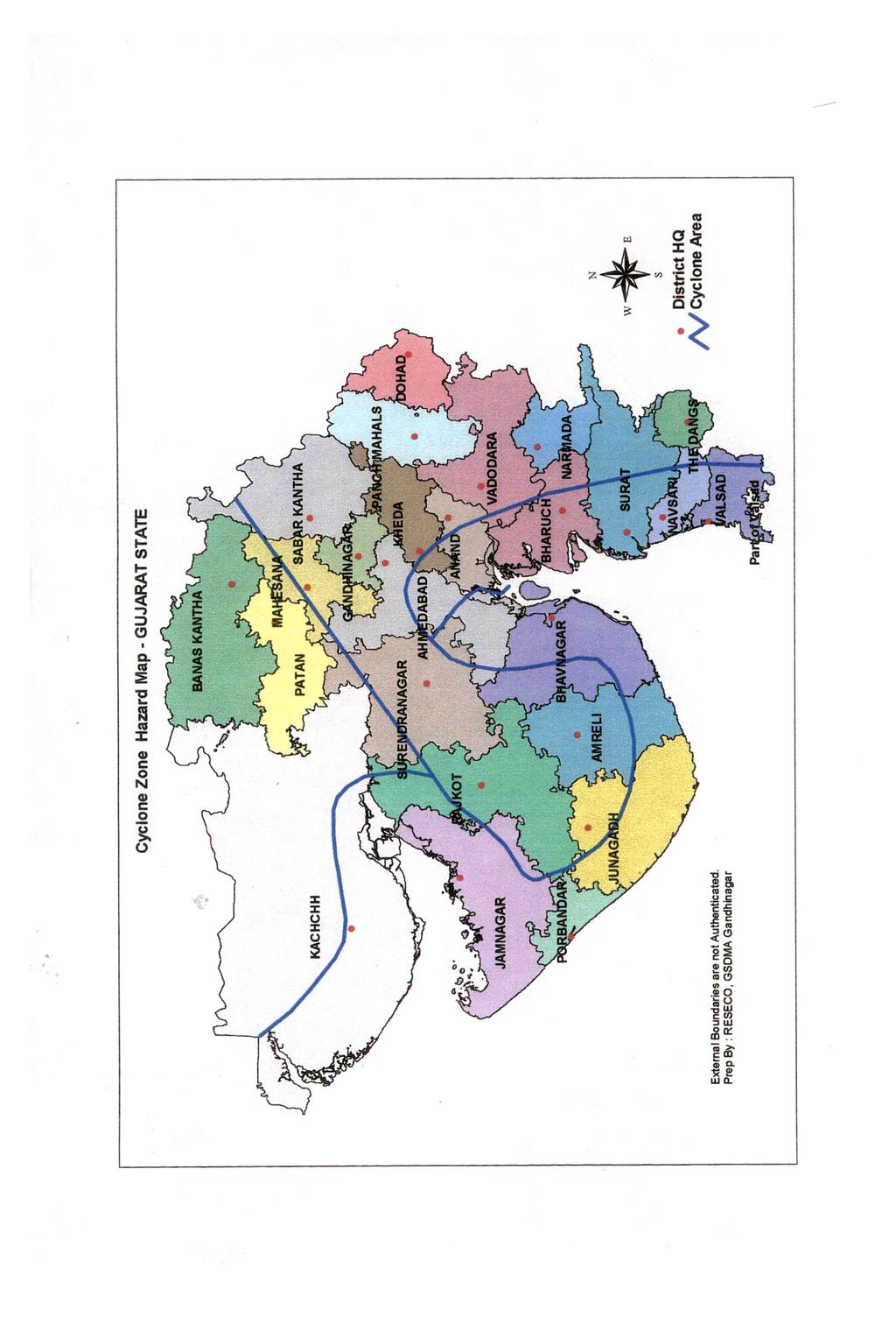
14 3.3.2 Physical Vulnerability Physical vulnerability relates to 14: Physical location of people (flood plains, low-lying areas, cyclone paths, fault zones) Human settlement s proximity to the hazard zone (this can be proximity to hazardous industry also apart from the natural hazard zone) Resistance offered to hazards by the shelter (technical capacity of the building) Standards of safety maintained to counter the effects Dependency on natural resources and environmental degradation (especially in droughts) For example people are only vulnerable to floods because they live in a flood prone area, physical vulnerability also relates to the technical capacity of buildings and structures to resist the forces acting upon them during a hazard event. It is apparent by now that the Gujarat is vulnerable to multiple hazards having multiplier effect. Out of the total 25 districts, the districts of Ahmedabad, Bharuch, Surat and Valsad are prone to all four hazards15 indicated in the Table 2. Other districts except Rajkot are prone to three hazards. Thus, more or less the entire state is prone to various kinds of natural hazards and more people are now vulnerable than ever before. It has also become apparent that, on the one hand, particular communities are periodically exposed to the same hazards, on the other hand, hazards are striking areas where they are not expected and also in higher magnitude. The industrialized part as well as the coastal area having major ports and gigantic industries hold enormous potential of devastation owing to the multiplier effect of natural phenomena that can strike on these units/areas. The Kandla port was affected very badly during the cyclone of The port handles chemicals that may prove to be extremely hazardous if any calamity strikes. While looking at the cyclone hazard map, it is apparent that starting with Ahmedabad district to Kutch, starting from the shore to some kilometers towards land, the whole of the coastline is in very high damage risk zone B (50m/sec wind speed) 86
15 Areas from Kheda district to Valsad, Silvassa and Dadra and Nagar Haveli, fall in the moderate risk zone (47m/sec wind speed). Thus, all the ports and industries falling in this belt are highly vulnerable to severe damages. The Earthquake Hazard Maps and the Flood Hazard Maps by BMTPC also indicate the state s physical vulnerability. The Earthquake Hazard map has indicated the underlying principle deep-seated faults, and major and minor faults. Though, the Flood Hazard Map has not indicated the low lying areas, it can be very useful with locally available data of low lying areas and other geographical characteristics are used for any further planning. From the earthquake hazard map of Gujarat, it is seen that almost whole of the State lies in seismic zones of probable Intensity IX (severest) to VII (moderate) on M.S.K. Intensity Scale. The Kutch district, which has 80.3 per cent of its areas in intensity IX Zone, has been subjected to earthquakes in India. Kutch has a long-standing history of earthquakes. Gujarat is located in the Himalayan collision zone where the Indo Australian tectonic plate slides under the more northern Eurasian plate in a predominantly northern direction at a rate of 2 centimeters per year. This process compresses the region and the crust is being forced into folds of young deposits. This process causes active fault lines below the surface of the ground known as blind thrust faults. These faults do not rupture the surface, but create rolling hills. There is evidence of at least four of these hill patterns in Gujarat.16. Most of the coastal areas of the state fall in the 50m/s (180km/h) wind velocity zone, other areas fall into 47m/s, 44m/s and 39m/s velocity zones. The state has experienced 24 cyclone crossings from 1850 to 2000 out of which 11 have been severe cyclonic storms. The probable maximum surge height that can be expected to strike the coast is as much as 5m above concurrent tide level. During the cyclone of 1998 there have been incidences of this height being 8 meters. A large proportion of the buildings in the state run the risk of moderate (M) to very high (VH) risk from high velocity winds. The nine districts that fall in the high-risk zone with cyclones partly or fully are Junagadh, Rajkot, Jamnagar, Amreli, Bhavnagar, Kheda, Surat, Bharuch and Kutch17 87
16 District Name Table : 3.4 Multi-hazard Prone Districts in Gujarat. Percent area under EQ Percent area Max. intensity, M.S.K. under wind Probable zone storm surge ht. IX or VIII VII Speed %of At coast line Percent area flood prone Unprote Protected more m/s area (m) cted Ahmedabad* Amreli Banaskantha Bharueh* Bhavnagar* Dang Gandhinagar : Jamnagar* Junagadh* Kutch* Kheda Mehsana Panchmahals Rajkot* Surat* Vadodara Valsad* Source: Vulnerability Atlas of India: Gujarat (*Districts prone to cyclone including storm surge) Gujarat is moderately prone to the floods hazard17. The Flood Hazard Map shows that the flood prone areas are mainly along the principal rivers in the state. The problems associated with these rivers are mainly inundation of areas due to spilling of riverbanks and inadequate drainage at places and erosion of banks. The Narmada, Sabarmati and Mahi basin frequently experiences river floods due to heavy rains in the upstream, and the Saurashtra region experiences floods due to excessive rainfall as in the years 1982, 1983 and While referring to relative importance of different ecological disasters for Gujarat, Earthquake, though envisaged once in 50 years, can create the most ruinous effects. Cyclones and floods with comparatively less vulnerability of the State can be dealt effectively. Earthquake with no warning and with most of the State s area under Zone-V to Zone-Ill, the risk involved is much higher. 88
17 Moreover, the Golden Corridor of Gujarat, though lying In the Moderate Damage Risk Zone (MSK VII) has the potential of great economic losses even with lower intensity earthquakes. Major Parts, the Golden Corridor and the Silver Corridor of Gujarat can prove to be ruinous if their potential of multiplier hazard is overlooked while planning out long-term mitigation and preparedness measures. The increase in damages due to disasters is being brought about by concentration of people in disaster - prone areas. Why this is occurring can be the topic of a volume all on its own. However, in terms of disasters, what it translates into is the understanding of increasing and changing vulnerability. 3.4 State Level Disaster Response In the context of the federal structure of the country, the responsibility to cope with natural disasters is essentially that of the state government. The role of the Central Government is supportive in terms of supplementation of physical and financial resources. Only two entries in the State list that are remotely related to the subject of disaster management are entry 14, which deals with agriculture, including protection against pests and plant diseases, and entry 17, which deals with water, including water supply, drainage and embankments. This is grossly inadequate, and disaster management needs to be included in the Seventh Schedule of the Constitution Set up at State level The nodal department for formulating, controlling, monitoring and directing measures for disaster preparedness and for organizing rescue and relief operations with necessary co-operation among all the departments of the state government. The chief secretary is in overall charge of the relief operations in the state and the Relief Commissioner and the Additional Relief Commissioner function under his direction and control. The State Relief Commissioner, is in charge of the relief and rehabilitation measures in the wake of natural disasters in 89
18 the State. In many states, the department of revenue is also in-charge of relief. The state government has framed the state contingency plan and relief manuals and the districts have their contingency plans that are updated from time to time. In case of a disaster, the state government invites NGOs and other national and international relief organizations to join in the efforts to reach out to the victims. GSDMA is a nodal agency formulated after Earthquake 2001 under and the chief minister chairs this authority. There have been many changes after the recent earthquake. Particularly for earthquake rehabilitation, there have been many committees formed at various levels. It is still not clear whether the committees would be functional after the rehabilitation stage19. State High Power Standing Committee: > Chief Secretary Chairperson > ACS, Finance Member > PS, Revenue Member > ACS, Agriculture Member > ACS, Home Member > Secretary, Civil Supplies Member > Secretary, Health Member > Secretary, Forest and Environment Member > PS, Roads and Buildings Member > Secretary, NWR and WR Member > Secretary, Ports and Fisheries Member > Director General of Police Member > PCC Forest Member > Relief Commissioner Member Secretary High Power Standing Committee A State level High Power Standing Committee chaired by the Chief Secretary functions with members from various departments to deal with all matters and situations arising out of natural calamities including disaster preparedness. 90
19 Figure : 3.1 Response and Inter action In Gujarat State on Occurrence of Disaster GOI Environment & Forest, Defence Telecom Civil Defence, Railways, Fire Advisor Meteorology, Police, Industries, Fire Brigade, Health, Irrigation & District Authorities * Dept s of GOG Revenue, Home, Health, Finance, Transport, Urban Dev., Irrigation, Industries, Roads & Building, Agriculture, Food & Civil Supply, Labour & Employment, Ports, Information f Director of Relief Relief Commissioner District Collector State Control Room/ Emergency Operations CWC IMD District Control Room Legends : District Relief Committee Information -----^ Instructions Feedback STATE REVENUE DEPARTMENT...Tech Asst. & Resource Mobilisation Tech.Asst., Resource Mobilisation, Coordination...^ Coordination & Feedback 91
20 During the occurrence and continuance of a natural calamity, the above committee of secretaries headed by the chief secretary functions to monitors the day-to-day situation and issues necessary directions to deal with the situation Sub-Committee Another sub-committee is chaired by Additional Chief Secretary/Principal Secretary Revenue and / or Commissioner of Relief which co-ordinates activities of all agencies, officials and non-officials engaged in relief operations. Liaison officers of all the departments are members of this sub-committee and the Director of Relief is member secretary of this committee and is responsible for coordinating with district authorities Commissioner of Relief A full time officer designated as Commissioner of Relief is the overall in charge of preparedness exercise, rescue, relief and rehabilitation operation in the state. ; Gujarat State Disaster Management Authority (GSDMA) The existing administrative structure to deal with the ravages of the earthquake were not found satisfactorily and hence the Gujarat government constituted the Gujarat State Disaster Management Authority on 8 February 2001 with the chief minister as chairperson and ten other members. The Resolution spoke of the need for a permanent arrangement to handle a calamity. It is therefore evident that the existing disaster management system at the state level was found inadequate. The objectives of the Gujarat State Disaster Management Authority are the following: To undertake rehabilitation and reconstruction as also social and economic activities for restoration of the situation. To make efforts to minimize the impact of natural disasters. To make the best use of funds, grants, donations, assistance etc received from the government of India and other foreign countries or any other 92
21 institution/persons for prevention of such natural calamities or handling the aftereffects. The jurisdiction of this authority will be the entire state and will work as an autonomous body. It has been registered as a society under the Societies Registration Act The government of Gujarat has also created a separate Rehabilitation and Reconstruction Division under the General Administration Department of the State Government and the work of the Gujarat State Disaster Management Authority has been transferred to the General Administration Department. Further, the State Government constituted a taskforce to suggest effective measures for preparation of a long-term Disaster Management Plan, headed by the Chief Executive Officer of the Gujarat State Disaster Management Authority The Gujarat State Disaster Management Authority constituted on the pattern of a similar authority formed in Orissa earlier has a CEO and two Additional CEOs. It has six Directors and a chief Engineer who look after different aspects of work relating to Disaster Management. The Chief Minister is the Chairperson of GSDMA and meets at least once a month. It has the powers of the state cabinet. Besides this, two committees have been constituted for redressal of grievances- one at the district level, which is headed by the Minister in charge of the concerned district and the other at the village level headed by an officer not below the rank of the deputy collector or Mamlatdar. GSDMA is also looking forward for long-term mitigation in the state. The path drawn abruptly today seems quite appropriate, although how much of it is put in practice, their approach and process will determine the future of the state with respect of disasters. GSDMA s plan ahead drawn in series of meetings by task force and in various workshops. It is yet to be given concrete shape; presently it is simply listing of all possible measures, suggested by various subject experts/representatives. While putting this points in a future strategy, what remains and what is left is not clear. (Refer Figure : 3.2) 93
22 Figure: 3.2 Gujarat State Disaster Management Authority General Administration Department, Government of Gujarat Chief Minister Chairperson Advisory Committee Chief Executive Officer Additional CEO Additional CEO Director Administrati Director-Disaster Management Director Housing & Emergency Communication Director Finance Chief Engineer (Procurement) Controller of Accounts 94
23 3.4.6 State and District level Contingency Plans The State level contingency plan is the consolidated plan (from district contingency plans) to be put in action on occurrence of a calamity. These contingency plans lay down specific action points, key personnel and contact points in relation to all aspects. However, these plans are not comprehensive in nature and are only response plans and do not take into account any mitigation or reduction measures. Action is initiated on the receipt of warning only. These plans require regular updating and further development into manuals and SOPs for guidance. Contingency plan at district level is prepared by the collector and approved by the state government. It is prepared in coordination with local defense personnel and other departments of Government State and District Control Rooms There is also provision of a well-equipped state of art control room. Presently, the State Control Room has hotlines with the District Control Room and coordinates relief activity and receives information from various districts. District Control Rooms do not function annually; Collectors start operating it generally before onset of monsoon, i.e. from June and so and operates till September and November. Staff from control room are seconded from other departments. The control room is responsible for: Transmitting to the Relief Commissioner information as to the development of crisis situation.. Receiving information and communicating to appropriate agencies for immediate action Collection and submission of information relating to implementation of relief measures to the Relief Commissioner Keeping the state level authorities apprised of the developments on a continuing basis. 95
24 3.5 District level Disaster Response The district collector is the focal point at the district level for directing, supervising and monitoring relief measures for disaster and for preparation of the district level plans. The collector jointly with the DDO exercises coordinating and supervisory powers over functionaries of all the departments at the district level. The actual day-to-day work of administering relief or implementing contingency plans and coordinating and supervisory powers over functionaries of all the departments at district level are the responsibility of the district collector. During actual operations for disaster mitigation or relief, the powers of the collector are considerably enhanced. In emergency, the state administration informally permits the collector to exercise higher powers and the competent authority later ratifies decisions. When a disaster is apprehended, the entire machinery of the district, including officers of technical and other departments, swings into action and maintains almost continuous contact with each village in the disaster threatened area. The role of sub-district administration is also crucial here Panchayati Raj Institutions and Local Self Governance It is a surprising fact that though the panchayati raj institutions in Gujarat have very good hold at local level, they do not have any active role to play during emergencies. Each layer of the system has some specific functions to perform during an emergency, which is well defined in the Panchayati Raj Act of But there are not given any financial assistance to perform any of such duties. This keeps their role limited and most of the time passive, though their close attachment to the public and good knowledge of crisis and resources can prove them as very good managers at such critical periods of time. Section 99 of the Gujarat Panchayat Act 1993 covers 106 different activities of the panchayats. The community development activities include the following two responsibilities during emergencies: Assistance to disabled, poor and sick people Assistance to all victims during occurrence of any natural calamity 96
25 Section 130 of the act mentions 86 responsibilities of the taluka panchayats. About emergency relief it says,...shall provide assistance during flood, fire, epidemic and any other such natural calamities. Districts panchayats are assigned a major role in emergencies. Section 154 mentions 73 tasks of the district panchayats and one of them is Establishing and managing relief camps during natural calamities like drought and famine, fire and earthquake. In a nutshell, emergency relief is part of the responsibilities of the panchayati raj institutions but they are not given any assistance to carry on such activities. They have no other role to play except providing all necessary data of damage and loss. Same is the case with municipalities and corporations21. 97
26 References Shah Jolly, State Environmental Action Programme^SEAP), (Report for GEC, Vadodara) Ahmedabad.l State Revenue Department Shri Jai Narain Vyas, Ex-Minister, Narmada and Water Resources, Gujarat State State Revenue Department State level Response Plan for Chemical, Industrial and Nuclear Hazards, Gujarat, GSDMA State Relief Manual Gupta L.C. & Vinod K. Sharma, Drought in Gujarat: and , National Centre for Disaster Management, Indian Institute of Public Administration, Socio-economic review -Gujarat State Agricultural Statistics at A Glance 1999, Ministry of Agriculture, Government of India. Statistical Abstract of Gujatrat State Buch, V.B. Vice Chairman, Sardar Sarovar Narmada Nigam Ltd. (SSNNL)," Meeting the Challenge of Development. Gujarat Earthquake Recovery Programme, ADB and World Bank Joint Assessment Report. Socio-economic review 2001, Government of Gujarat. Kumar Santosh, Disaster Management, Analysing Vulnerability, Disaster Mitigation: Experiences and Reflection. BMTPC, Gujarat.Vulnerability Atlas of India, Ministry of Urban Development, New Delhi, 1997 ; Merh S.S., Role of active tectonism in evolution ofkutch Landscape. BMTPC, Gujarat.Vulnerability Atlas of India, Ministry of Urban Development, New Delhi, 1997 Shah Jolly, State Environmental Action Programme(SEAP), (Report for GEC, Vadodara) Ahmedabad
27 State level consolidated Cyclone and Flood Action Plan, State Revenue Department. Gupta M.C., Vinod K. Sharma, L.C.Gupta, B.K. Tamini (ed), Manual on Natural Disaster Management in India, (National Centre for Disaster Management, IIP A, New Delhi, 2001) Department of Acriculture and Co-operation, High Powered Committee on Disaster Management: Report, Ministry of Agriculture, Government of India, 2000 and Hemantkumar Shah, Gujaratma Kudarti Aapatti Ane Sarkari Kharch, Disaster Mitigation Institute, Ahmedanad,
Pacific Catastrophe Risk Assessment And Financing Initiative
 Pacific Catastrophe Risk Assessment And Financing Initiative VANUATU September 211 Country Risk Profile: VANUATU is expected to incur, on average, 48 million USD per year in losses due to earthquakes and
Pacific Catastrophe Risk Assessment And Financing Initiative
 Pacific Catastrophe Risk Assessment And Financing Initiative PALAU September is expected to incur, on average,.7 million USD per year in losses due to earthquakes and tropical cyclones. In the next 5 years,
SEISMIC RISK ASSESSMENT IN ARMENIA
 SEISMIC RISK ASSESSMENT IN ARMENIA Hovhannes Khangeldyan Head of National Crisis Management Center Rescue Service Ministry of Emergency Situations of the Republic of Armenia Tokyo, 2016 ARMENIA: GEOGRAPHICAL
Pacific Catastrophe Risk Assessment And Financing Initiative
 Pacific Catastrophe Risk Assessment And Financing Initiative TUVALU is expected to incur, on average,. million USD per year in losses due to earthquakes and tropical cyclones. In the next 5 years, has
Impact of Cyclone Nargis
 Lessons Learnt from Nargis Recovery for the Next Disaster International Recovery Forum (2011) 12, JAN 2011, Kobe, Japan Home for over 100 national races. Profile of Myanmar The 2 nd largest country in
Pacific Catastrophe Risk Assessment And Financing Initiative
 Pacific Catastrophe Risk Assessment And Financing Initiative TIMOR-LESTE September Timor-Leste is expected to incur, on average, 5.9 million USD per year in losses due to earthquakes and tropical cyclones.
Initiative. Country Risk Profile: papua new guinea. Better Risk Information for Smarter Investments PAPUA NEW GUINEA.
 Pacific Catastrophe Risk Assessment And Financing Initiative PAPUA NEW GUINEA September 211 Country Risk Profile: papua new is expected to incur, on average, 85 million USD per year in losses due to earthquakes
Flood Hazard Vulnerability Mapping Using Remote Sensing and GIS: A Case Study of Surat Dhruvesh KM 1*, Praful MU 2 and Aditya MV 1 1
 Flood Hazard Vulnerability Mapping Using Remote Sensing and GIS: A Case Study of Surat Dhruvesh KM 1*, Praful MU 2 and Aditya MV 1 1 CU Shah University, Wadhwan, India 2 ISTAR-CVM, Vallabh Vidyanagar,
Disaster RISK Management : Bhutanese Scenario
 Disaster RISK Management : Bhutanese Scenario Expert Group Meeting (EGM) on Geo-referenced Information Systems for Disaster Risk Management (Geo-DRM) and sustaining the Community of Practice (COP), Bangkok,
RISK OF PRINCIPAL DISASTERS IN INDIA AND IMPACTS OF DISASTERS ON ECONOMIC DEVELOPMENT
 RISK OF PRINCIPAL DISASTERS IN INDIA AND IMPACTS OF DISASTERS ON ECONOMIC DEVELOPMENT At the Himachal Pradesh Institute of Public Administration Shimla 05. 05.2012 Improve Disaster Management with the
A Presentation By: Dr. G. M. Dar Centre for Disaster Management & Env. Studies, J&K IMPA, Srinagar
 A Presentation By: Dr. G. M. Dar Centre for Disaster Management & Env. Studies, J&K IMPA, Srinagar Introduction Disaster: Sudden or great misfortune. A catastrophe, a calamitous event. Hazards are a natural
DIPLOMA IN DISASTER MANAGEMENT. (Non-Semester) (With effect from the academic year )
 (With effect from the academic year )") DIPLOMA IN DISASTER MANAGEMENT (Non-Semester) (With effect from the academic year 2013-14) Eligibility for the Course Candidate should have passed the Higher Secondary Examination conducted by the Board
DIPLOMA IN DISASTER MANAGEMENT (Non-Semester) (With effect from the academic year 2013-14) Eligibility for the Course Candidate should have passed the Higher Secondary Examination conducted by the Board
Status and Challenges on Geo-DRM Information Systems in Tonga
 Name: Mafua- i-vai utukakau Maka Status and Challenges on Geo-DRM Information Systems in Tonga 1 Roles and Relationships Land and Geographic Information Systems (LGIS) Unit: Establish updated high-resolution
Use of Geospatial data for disaster managements
 Use of Geospatial data for disaster managements Source: http://alertsystemsgroup.com Instructor : Professor Dr. Yuji Murayama Teaching Assistant : Manjula Ranagalage What is GIS? A powerful set of tools
- facilitate the preparation of landslide inventory and landslide hazard zonation maps for the city, - development of precipitation thresholds,
 Date of Submission 29.03.2012 IPL Project Proposal Form 2012 (MAXIMUM: 3 PAGES IN LENGTH) 1. Project Title: (2 lines maximum)-introducing Community-based Early Warning System for Landslide Hazard Management
Republic of Mozambique
 Republic of Mozambique Second Expert's Symposium on Multi-Hazard Early Warning Systems with focus on the Role of National Meteorological and Hydrological Services 5-7 May 2009, Toulouse France 1. Background
Country Report Nepal Geospatial Data Sharing Initiatives of Survey Department Supporting Disaster Management
 Third JPTM Step 2 for Sentinel Asia 6-8 July, 2010 Manila, The Philippines Country Report Nepal Geospatial Data Sharing Initiatives of Survey Department Supporting Disaster Management Durgendra M Kayastha
Disaster Prevention and Management in Asia: The Context of Human Security and Its Relevance to Infrastructure Planning and Management
 Disaster Prevention and Management in Asia: The Context of Human Security and Its Relevance to Infrastructure Planning and Management Rajib Shaw http://www.iedm.ges.kyoto-u.ac.jp/ Contents Background and
MEGACITIES AND DISASTER RISK - THE CASE OF MUMBAI
 Municipal Corporation of Greater Mumbai, India MEGACITIES AND DISASTER RISK - THE CASE OF MUMBAI Presentation by S S KSHATRIYA Municipal Commissioner MUMBAI Largest city in India 6 th Largest metropolis
They include earthquakes, volcanic eruptions, floods, landslides, and other processes and occurrences. They are included in the broader concept of.
 They include earthquakes, volcanic eruptions, floods, landslides, and other processes and occurrences. They are included in the broader concept of. In general, natural processes are labeled hazardous only
Disaster Management and Spatial Data An Experience of Sri Lanka for Joint project team meeting 2012
 Disaster Management and Spatial Data An Experience of Sri Lanka for Joint project team meeting 2012 1 by Padma Kumara Withana Provincial Surveyor General Uva Province 2 Out line ü Introduction ü Natural
Fish Pond. Old Secretariate. Shaheed Smarak
 Fish Pond Old Secretariate Shaheed Smarak HOW SATELLITE SCANS EARTH. Rajbhawan area viewed by IKONOS 1 meter sensor Very high resolution (40 cm) Orbi-Image data Higher the resolution better the geometric
Challenges and Potentials of Place Based Information Management in Nepal"
 Nineteenth United Nations Regional Cartographic Conference for Asia and the Pacific, Bangkok, Thailand, 29 October 1 November 2012 Challenges and Potentials of Place Based Information Management in Nepal"
International Journal of Modern Trends in Engineering and Research e-issn No.: , Date: April, 2016
 International Journal of Modern Trends in Engineering and Research www.ijmter.com e-issn No.:2349-9745, Date: 28-30 April, 2016 Landslide Hazard Management Maps for Settlements in Yelwandi River Basin,
Disaster Risk Management in India. Kamal Kishore New Delhi, 27 October 2016
 Disaster Risk Management in India Kamal Kishore New Delhi, 27 October 2016 Hazard, Exposure and Vulnerability Disaster Prevention Mitigation Hurricane Matthew: Cuba & Haiti Emergency Response Coordination
PRE MONSOON TROPICAL CYCLONE ALERT (LAILA)
") PRE MONSOON TROPICAL CYCLONE ALERT (LAILA) (Updated as on 19 th May, 2010, 10.00 AM) A pre-monsoon Tropical Cyclone alert has been issued for all the coastal districts of Orissa by the Special Relief Commissioner
PRE MONSOON TROPICAL CYCLONE ALERT (LAILA) (Updated as on 19 th May, 2010, 10.00 AM) A pre-monsoon Tropical Cyclone alert has been issued for all the coastal districts of Orissa by the Special Relief Commissioner
Landslide Hazard Assessment Methodologies in Romania
 A Scientific Network for Earthquake, Landslide and Flood Hazard Prevention SciNet NatHazPrev Landslide Hazard Assessment Methodologies in Romania In the literature the terms of susceptibility and landslide
Measuring Disaster Risk for Urban areas in Asia-Pacific
 Measuring Disaster Risk for Urban areas in Asia-Pacific Acknowledgement: Trevor Clifford, Intl Consultant 1 SDG 11 Make cities and human settlements inclusive, safe, resilient and sustainable 11.1: By
Technical Article TRICOLITE. Pledged to Excellence SAFE, EFFICIENT, RELIABLE POWER DISTRIBUTION SOLUTIONS
 Technical Article SAFE, EFFICIENT, RELIABLE POWER DISTRIBUTION SOLUTIONS EARTHQUAKES & SEISMIC COMPLIANCE OF LV SWITCHGEAR ASSEMBLY Random vibrations, such as those caused by an earthquake, cause shocks
5.2. IDENTIFICATION OF NATURAL HAZARDS OF CONCERN
 5.2. IDENTIFICATION OF NATURAL HAZARDS OF CONCERN To provide a strong foundation for mitigation strategies considered in Sections 6 and 9, County considered a full range of natural hazards that could impact
Report on Disaster statistics of Nepal
 Report on Disaster statistics of Nepal Submitted by Altaf Rehman Submitted to Dr. Naveed Ahmed University of engineering and technology Peshawar Assignment 1 Section A Registration id 14PWCIV456 Page 1
Summary and Conclusions
 241 Chapter 10 Summary and Conclusions Kerala is situated in the southern tip of India between 8 15 N and 12 50 N latitude and 74 50 E and 77 30 E longitude. It is popularly known as Gods own country.
Oregon APA Legal Issues Workshop December 7, Tricia Sears, DLCD With information from Bill Burns, DOGAMI
 Oregon APA Legal Issues Workshop December 7, 2018 Tricia Sears, DLCD With information from Bill Burns, DOGAMI How this Topic Arrived WE FREQUENTLY HEAR CONCERNS ABOUT LIABILITY AND TAKINGS. Current federal
Disclaimer. This report was compiled by an ADRC visiting researcher (VR) from ADRC member countries.
 from ADRC member countries.") Disclaimer This report was compiled by an ADRC visiting researcher (VR) from ADRC member countries. The views expressed in the report do not necessarily reflect the views of the ADRC. The boundaries and
Disclaimer This report was compiled by an ADRC visiting researcher (VR) from ADRC member countries. The views expressed in the report do not necessarily reflect the views of the ADRC. The boundaries and
Georeferencing and Satellite Image Support: Lessons learned, Challenges and Opportunities
 Georeferencing and Satellite Image Support: Lessons learned, Challenges and Opportunities Shirish Ravan shirish.ravan@unoosa.org UN-SPIDER United Nations Office for Outer Space Affairs (UNOOSA) UN-SPIDER
Flash flood disaster in Bayangol district, Ulaanbaatar
 Flash flood disaster in Bayangol district, Ulaanbaatar Advanced Training Workshop on Reservoir Sedimentation Management 10-16 October 2007. IRTCES, Beijing China Janchivdorj.L, Institute of Geoecology,MAS
What Are Disasters? The Rescue Kids Trio!
 The Rescue Kids Trio! What Are Disasters? This manual was made possible through funding by the Council of Local Authorities for International Relations. Disasters and emergency preparedness Emergency preparedness
Geography Class XI Fundamentals of Physical Geography Section A Total Periods : 140 Total Marks : 70. Periods Topic Subject Matter Geographical Skills
 Geography Class XI Fundamentals of Physical Geography Section A Total Periods : 140 Total Marks : 70 Sr. No. 01 Periods Topic Subject Matter Geographical Skills Nature and Scope Definition, nature, i)
The AIR Tropical Cyclone Model for India
 The AIR Tropical Cyclone Model for India Tropical cyclones have caused millions, and even billions, of dollars in damage in India. The growing number of properties on the coast, together with growing insurance
CURRENT AND FUTURE TROPICAL CYCLONE RISK IN THE SOUTH PACIFIC
 CURRENT AND FUTURE TROPICAL CYCLONE RISK IN THE SOUTH PACIFIC COUNTRY RISK PROFILE: SAMOA JUNE 2013 Samoa has been affected by devastating cyclones on multiple occasions, e.g. tropical cyclones Ofa and
RETA 6422: Mainstreaming Environment for Poverty Reduction Category 2 Subproject
 RETA 6422: Mainstreaming Environment for Poverty Reduction Category 2 Subproject A. Basic Data 1. Subproject Title: Poverty-Environment Mapping to Support Decision Making 2. Country Director: Adrian Ruthenberg
MALDIVES. Regional Expert Workshop On Land Accounting For SDG Monitoring & Reporting (25-27 th Sept 2017) - Fathimath Shanna, Aishath Aniya -
 - Fathimath Shanna, Aishath Aniya -") MALDIVES Regional Expert Workshop On Land Accounting For SDG Monitoring & Reporting (25-27 th Sept 2017) - Fathimath Shanna, Aishath Aniya - ABOUT MALDIVES Approximately 860 km long and 120 km wide Consists
MALDIVES Regional Expert Workshop On Land Accounting For SDG Monitoring & Reporting (25-27 th Sept 2017) - Fathimath Shanna, Aishath Aniya - ABOUT MALDIVES Approximately 860 km long and 120 km wide Consists
Flood hazard mapping in Urban Council limit, Vavuniya District, Sri Lanka- A GIS approach
 International Research Journal of Environment Sciences E-ISSN 2319 1414 Flood hazard mapping in Urban Council limit, Vavuniya District, Sri Lanka- A GIS approach Abstract M.S.R. Akther* and G. Tharani
UNIT 11 SOUTH ASIA SG 1 - PHYSICAL GEOGRAPHY & THE ENVIRONMENT
 UNIT 11 SOUTH ASIA SG 1 - PHYSICAL GEOGRAPHY & THE ENVIRONMENT I. PHYSICAL GEOGRAPHY TAKE OUT YOUR PHYSICAL MAP OF SOUTH ASIA A. The Himalayan Mountains form the northern boundary of the region (color
MOZAMBIQUE: Institutional Arrangements and Achievements
 UN-International Strategy for Disaster Reduction Global Platform for Disaster Risk Reduction- First Session MOZAMBIQUE: Institutional Arrangements and Achievements on Implementation of Hyogo Framework
Geospatial Technologies for Resources Planning & Management
 Geospatial Technologies for Resources Planning & Management Lal Samarakoon, PhD Director, Geoinformatics Center Asian Institute of Technology, Thailand Content Geoinformatics for SDG Information Integration
DISASTER INFORMATION MANAGEMENT SYSTEM Sri Lanka
 DISASTER INFORMATION MANAGEMENT SYSTEM Sri Lanka 15 March 2016 - Partnership Meeting Global Centre for Disaster Statistics SRIMAL SAMANSIRI ASSISTANT DIRECTOR R&D DISASTER MANAGEMENT CENTRE Overview Country
CHAPTER 4 HIGH LEVEL SPATIAL DEVELOPMENT FRAMEWORK (SDF) Page 95
 Page 95") CHAPTER 4 HIGH LEVEL SPATIAL DEVELOPMENT FRAMEWORK (SDF) Page 95 CHAPTER 4 HIGH LEVEL SPATIAL DEVELOPMENT FRAMEWORK 4.1 INTRODUCTION This chapter provides a high level overview of George Municipality s
CHAPTER 4 HIGH LEVEL SPATIAL DEVELOPMENT FRAMEWORK (SDF) Page 95 CHAPTER 4 HIGH LEVEL SPATIAL DEVELOPMENT FRAMEWORK 4.1 INTRODUCTION This chapter provides a high level overview of George Municipality s
National Disaster Management Centre (NDMC) Republic of Maldives. Location
 Republic of Maldives. Location") National Disaster Management Centre (NDMC) Republic of Maldives Location Country Profile 1,190 islands. 198 Inhabited Islands. Total land area 300 sq km Islands range b/w 0.2 5 sq km Population approx.
National Disaster Management Centre (NDMC) Republic of Maldives Location Country Profile 1,190 islands. 198 Inhabited Islands. Total land area 300 sq km Islands range b/w 0.2 5 sq km Population approx.
Syllabus Post Graduate Diploma in Disaster Management (PGDDM)
") Syllabus Post Graduate Diploma in Disaster Management (PGDDM) Programme Objective: The Programme has been framed with an intention to provide a general concept in the dimensions of disasters caused by
Syllabus Post Graduate Diploma in Disaster Management (PGDDM) Programme Objective: The Programme has been framed with an intention to provide a general concept in the dimensions of disasters caused by
Why Are Communities at Risk from Coastal Hazards?
 Chapter 2 Why Are Communities at Risk from Coastal Hazards? The Indian Ocean Tsunami of December 2004 raised awareness worldwide of the potentially devastating impacts of tsunamis. Coastal communities
INTRODUCTION. Climate
 INTRODUCTION Climate Landslides are serious natural disasters in many parts of the world. Since the past 30 years, rainfall triggered landslides and debris flows had been one of the natural disasters of
M14/3/GEOGR/SP2/ENG/TZ0/XX/Q GEOGRAPHY STANDARD LEVEL PAPER 2. Monday 19 May 2014 (morning) 1 hour 20 minutes INSTRUCTIONS TO CANDIDATES
 1 hour 20 minutes INSTRUCTIONS TO CANDIDATES") M14/3/GEOGR/SP2/ENG/TZ0/XX/Q 22145203 GEOGRAPHY STANDARD LEVEL PAPER 2 Monday 19 May 2014 (morning) 1 hour 20 minutes INSTRUCTIONS TO CANDIDATES Do not open this examination paper until instructed to do
M14/3/GEOGR/SP2/ENG/TZ0/XX/Q 22145203 GEOGRAPHY STANDARD LEVEL PAPER 2 Monday 19 May 2014 (morning) 1 hour 20 minutes INSTRUCTIONS TO CANDIDATES Do not open this examination paper until instructed to do
DROUGHT RISK EVALUATION USING REMOTE SENSING AND GIS : A CASE STUDY IN LOP BURI PROVINCE
 DROUGHT RISK EVALUATION USING REMOTE SENSING AND GIS : A CASE STUDY IN LOP BURI PROVINCE K. Prathumchai, Kiyoshi Honda, Kaew Nualchawee Asian Centre for Research on Remote Sensing STAR Program, Asian Institute
DISASTER MANAGEMENT AND PREPAREDNESS PLAN
 DISASTER MANAGEMENT AND PREPAREDNESS PLAN Publisher : M.Thennarasan IAS Municipal ommissioner oncept by : Implimantation : B. I. Desai Deputy ommissioner D. M. Jariwala Addi.ity Eng. (ivil) ompilation
5.2 IDENTIFICATION OF HAZARDS OF CONCERN
 5.2 IDENTIFICATION OF HAZARDS OF CONCERN 2015 HMP Update Changes The 2010 HMP hazard identification was presented in Section 6. For the 2015 HMP update, the hazard identification is presented in subsection
National Spatial Development Perspective (NSDP) Policy Coordination and Advisory Service
 Policy Coordination and Advisory Service") National Spatial Development Perspective (NSDP) Policy Coordination and Advisory Service 1 BACKGROUND The advances made in the First Decade by far supersede the weaknesses. Yet, if all indicators were
National Spatial Development Perspective (NSDP) Policy Coordination and Advisory Service 1 BACKGROUND The advances made in the First Decade by far supersede the weaknesses. Yet, if all indicators were
Geospatial application in Kiribati
 Geospatial application in Kiribati ICC-21 ST RESAP (9 TH TO 13 TH OCTOBER, 2017) BANGKOK, THAILAND Outline Kiribati Profile Natural disasters in Kiribati Achievements Challenges/Issues Ways forward 1 Kiribati
Assessing Hazards and Risk
 Page 1 of 6 EENS 204 Tulane University Natural Disasters Prof. Stephen A. Nelson Assessing Hazards and Risk This page last updated on 07-Jan-2004 As discussed before, natural disasters are produced by
By Lillian Ntshwarisang Department of Meteorological Services Phone:
 By Lillian Ntshwarisang Department of Meteorological Services Phone: +267 3612200 Email: lntshwarisang@gov.bw/ lntshwarisang@gmail.com Introduction Mandate of DMS Function of the Department Services to
Impacts of Climate Change and Water-Related Disaster Reduction Management in the Asia-Pacific Region
 Impacts of Climate Change and Water-Related Disaster Reduction Management in the Asia-Pacific Region Katumi MUSIAKE Professor, Fukushima University Secretary General, Asia Pacific Association of Hydrology
Bhutan Country Report for JPTM 2010 (July, 2010) Department of Disaster Management Ministry of Home & Cultural Affairs Royal Government of Bhutan
 Department of Disaster Management Ministry of Home & Cultural Affairs Royal Government of Bhutan") Bhutan Country Report for JPTM 2010 (July, 2010) Department of Disaster Management Ministry of Home & Cultural Affairs Royal Government of Bhutan 1 Contents of Presentation 1. Disaster Hazards and Underlying
Bhutan Country Report for JPTM 2010 (July, 2010) Department of Disaster Management Ministry of Home & Cultural Affairs Royal Government of Bhutan 1 Contents of Presentation 1. Disaster Hazards and Underlying
STATUS OF HAZARD MAPS VULNERABILITY ASSESSMENTS AND DIGITAL MAPS
 JapanInternational Cooperation Agency STATUS OF HAZARD MAPS VULNERABILITY ASSESSMENTS AND DIGITAL MAPS ANGUILLA REPORT THE CARIBBEAN DISASTER EMERGENCY RESPONSE AGENCY () Table of Contents Page Preface
DAGUPAN CITY EXPERIENCES, GOOD PRACTICES, CHALLENGES AND LESSONS LEARNED ON DISASTER RISK MANAGEMENT
 DAGUPAN CITY EXPERIENCES, GOOD PRACTICES, CHALLENGES AND LESSONS LEARNED ON DISASTER RISK MANAGEMENT Reducing Vulnerability to Climate Change Impacts and Related Natural Disasters in East Asia 12 and 13
Disaster Risk Assessment: Opportunities for GIS and data management with Open DRI
 Disaster Risk Assessment: Opportunities for GIS and data management with Open DRI Jacob Opadeyi Department of Geomatics Engineering and Land Management, The University of the West Indies, St. Augustine,
CHAPTER 5 PLAN OUTLAYS
 Five Year Plan CHAPTER 5 PLAN OUTLAYS A&N Islands was given the status of a Union Territory on 1 st November, 1956. Till then it was a part D state and was borne on the Budget of the Union Home Ministry.
Vietnam Coastal Erosion - Cause and Challenges -
 Administration of Sea and Islands Center for Oceanography University of Transport and Communications, Hanoi Vietnam Vietnam Coastal Erosion - Cause and Challenges - Presenters: Pham Hoang KIEN Le Van CONG
Roadmap to Stability
 Landslide Policy Committee for Aizawl City February 2014 Technical Support by: Aizawl is in earthquake hazard zone V and highly prone to natural, man-made and earthquake induced landslides. In order to
Fukien Secondary School Monthly Vocabulary/Expression List for EMI Subjects Secondary Two. Subject: Geography
 Focus: General Specific : Section Two : Unit One 1 Landslide 2 Downslope movement 3 Rock 4 Soil 5 Gravity 6 Natural hazard 7 Rainwater 8 Friction 9 Hilly relief 10 Unstable 11 Season 12 Saturated 13 Construction
3. HYDROMETEROLOGY. 3.1 Introduction. 3.2 Hydro-meteorological Aspect. 3.3 Rain Gauge Stations
 3. HYDROMETEROLOGY 3.1 Introduction Hydrometeorology is a branch of meteorology and hydrology that studies the transfer of water and energy between the land surface and the lower atmosphere. Detailed hydrological
DROUGHT ASSESSMENT USING SATELLITE DERIVED METEOROLOGICAL PARAMETERS AND NDVI IN POTOHAR REGION
 DROUGHT ASSESSMENT USING SATELLITE DERIVED METEOROLOGICAL PARAMETERS AND NDVI IN POTOHAR REGION Researcher: Saad-ul-Haque Supervisor: Dr. Badar Ghauri Department of RS & GISc Institute of Space Technology
W E E K L Y MONSOON INSIGHT
 W E E K L Y MONSOON INSIGHT 08 th July 2016 Indian Monsoon Dynamics Recent Weather Development India received 35% surplus rainfall in the week ended 6 July with all regions recording above-normal rainfall
Department of Geography: Vivekananda College for Women. Barisha, Kolkata-8. Syllabus of Post graduate Course in Geography
 India: Regional Problems and Resource management Module 11 (Full Marks 50) Unit I: Region and Regionalisation 1.1 Various bases of regionalisation of India; problems of identification and delineation.
Vulnerability of Bangladesh to Cyclones in a Changing Climate
 Vulnerability of Bangladesh to Cyclones in a Changing Climate Susmita Dasgupta Kiran Pandey Mainul Huq Zahirul Huq Khan M.M. Zahid Ahmed Nandan Mukherjee Malik Fida Khan 2010 Bangladesh: Tropical Cyclone
Earthquake Disaster Management in India
 Earthquake Disaster Management in India Akshay B. Ahlawat JRF in Geography Abstract: The fact is that natural disasters are always unexpected events which affect human life as well as nature itself. Earthquakes
The Case of the El Nino
 Page 1 of 5 Reducing the Impact of Environmental Emergencies Through Early Warning and Preparedness The Case of El Niño-Southern Oscillation (ENSO) Home >> Bangladesh Executive Summary Bangladesh Country
Regional EGM on Community of Practice of Georeferenced Information System. for Disaster Risk Management (Geo-DRM) April 2014, Bangkok, Thailand
 April 2014, Bangkok, Thailand") Regional EGM on Community of Practice of Georeferenced Information System for Disaster Risk Management (Geo-DRM) 23-25 April 2014, Bangkok, Thailand Presented By Mukesh Kumar Keshari Ministry of Home Affairs
Regional EGM on Community of Practice of Georeferenced Information System for Disaster Risk Management (Geo-DRM) 23-25 April 2014, Bangkok, Thailand Presented By Mukesh Kumar Keshari Ministry of Home Affairs
Study of Hydrometeorology in a Hard Rock Terrain, Kadirischist Belt Area, Anantapur District, Andhra Pradesh
 Open Journal of Geology, 2012, 2, 294-300 http://dx.doi.org/10.4236/ojg.2012.24028 Published Online October 2012 (http://www.scirp.org/journal/ojg) Study of Hydrometeorology in a Hard Rock Terrain, Kadirischist
ISSUES BRIEF Plenary A Risk-informed Approach to Sustainable Development and Resilience for Countries in Special Situations
 ISSUES BRIEF Plenary A Risk-informed Approach to Sustainable Development and Resilience for Countries in Special Situations Rationale All recent international agreements, including the Sendai Framework
GEOSPATIAL TECHNOLOGY IN HUMANITARIMAPPING A CASE STUDY OF KOSI RIVER FLOODS: 2008, INDIA
 GEOSPATIAL TECHNOLOGY IN HUMANITARIMAPPING A CASE STUDY OF KOSI RIVER FLOODS: 2008, INDIA APARAJITA GAHTAK ACTED, India B5/18, Safderjung Enclave, New Delhi 110029 Delhi.gis@acted.org Abstract: About the
Report. Developing a course component on disaster management
 Report Developing a course component on disaster management By Chira Prangkio Tawee Chaipimonplin Department of Geography, Faculty of Social Sciences, Chiang Mai University Thailand Presented at Indian
World Meteorological Organization
 World Meteorological Organization Opportunities and Challenges for Development of Weather-based Insurance and Derivatives Markets in Developing Countries By Maryam Golnaraghi, Ph.D. Head of WMO Disaster
UGRC 144 Science and Technology in Our Lives/Geohazards
 UGRC 144 Science and Technology in Our Lives/Geohazards Session 1 Introduction to Hazards and Disasters Dr. Patrick Asamoah Sakyi Department of Earth Science, UG, Legon College of Education School of Continuing
Assessing Social Vulnerability to Biophysical Hazards. Dr. Jasmine Waddell
 Assessing Social Vulnerability to Biophysical Hazards Dr. Jasmine Waddell About the Project Built on a need to understand: The pre-disposition of the populations in the SE to adverse impacts from disaster
CHAPTER 12 NATURAL DISASTERS
 CHAPTER 12 NATURAL DISASTERS In this chapter, you learn about the following: Natural calamities cyclones causes, effects and preventive measures Floods causes, affected areas, effects and control Land
GEOGRAPHY. In relation to the above aims, candidates should, after completing this syllabus, be able to
 GEOGRAPHY AIMS The aims of this syllabus are to enable candidates 1. to recognize and understand the arrangement of phenomena and features on Earth as well as the inter-relationship and interaction among
Poverty and Hazard Linkages
 Poverty and Hazard Linkages Global Risk Identification Programme Proposal Development Coordination Meeting Friday, 19 May 2006 CIESIN Earth Institute Columbia University www.ciesin.columbia.edu Data Improvements
The World Bank Ecuador Risk Mitigation and Emergency Recovery Project (P157324)
") Public Disclosure Authorized LATIN AMERICA AND CARIBBEAN Ecuador Social, Urban, Rural and Resilience Global Practice Global Practice IBRD/IDA Investment Project Financing FY 2016 Seq No: 2 ARCHIVED on
Public Disclosure Authorized LATIN AMERICA AND CARIBBEAN Ecuador Social, Urban, Rural and Resilience Global Practice Global Practice IBRD/IDA Investment Project Financing FY 2016 Seq No: 2 ARCHIVED on
Disaster Management in Bhutan
 ROYAL GOVERNMENT OF BHUTAN Disaster Management in Bhutan Tshering Wangchuk ROYAL GOVERNMENT OF BHUTAN EARTH FIRE WATER AIR ROYAL GOVERNMENT OF BHUTAN Presentation Outline Various Hazards in Bhutan Major
Sri Lanka Enhancing the Role of ICTs for Disaster Risk Management
 Workshop on ICT for Promoting Inclusive and Disaster Resilient Development Ulaanbaatar, Mongolia Sri Lanka Enhancing the Role of ICTs for Disaster Risk Management Kanchana Thudugala Programme Head, eservices
Table-Top Exercise for Emergency Preparedness Evaluation: Little Anse, Isle Madame
 Table-Top Exercise for Emergency Preparedness Evaluation: Little Anse, Isle Madame Alexander Chung, M.Sc. Candidate C-Change Student Research Associate May 2013 The Community of Little Anse Coastal community
Assumption Parish Hazard Mitigation Plan Update Public Meeting. September 1, 2015 Napoleonville, LA
 Assumption Parish Hazard Mitigation Plan Update Public Meeting September 1, 2015 Napoleonville, LA Agenda Hazard Mitigation Planning Process SDMI Staff Risk Assessment SDMI Staff Update on Previous/Current
CLIMATE READY BOSTON. Climate Projections Consensus ADAPTED FROM THE BOSTON RESEARCH ADVISORY GROUP REPORT MAY 2016
 CLIMATE READY BOSTON Sasaki Steering Committee Meeting, March 28 nd, 2016 Climate Projections Consensus ADAPTED FROM THE BOSTON RESEARCH ADVISORY GROUP REPORT MAY 2016 WHAT S IN STORE FOR BOSTON S CLIMATE?
HYDERABAD STUDY CIRCLE CIVILS PRELIMS (GS) - TEST SERIES SCHEDULE Ancient India I
 - TEST SERIES SCHEDULE Ancient India I") HYDERABAD STUDY CIRCLE CIVILS PRELIMS (GS) - TEST SERIES SCHEDULE 2018 Date No. 24-02-2018-1 Geography - I India location, Size Structure and Physiography Drainage system + map Pointing (India) Ancient
HYDERABAD STUDY CIRCLE CIVILS PRELIMS (GS) - TEST SERIES SCHEDULE 2018 Date No. 24-02-2018-1 Geography - I India location, Size Structure and Physiography Drainage system + map Pointing (India) Ancient
1. 1 What hazard maps have been developed in your country?
 REPUBLIC OF SLOVENIA MINISTRY OF DEFENCE ADMINISTRATION FOR CIVIL PROTECTION AND DISASTER RELIEF Kardeljeva plošcad 21, 1000 Ljubljana telephone: (+386) 1 471 33 22, fax: (+386) 1 431 81 17 ANSWERS TO
Perception of Earthquake Risk and Postdisaster
 Perception of Earthquake Risk and Postdisaster Reconstruction: Comparative Study of Two Residential Neighborhoods on Different Socio-economic Status in Tehran Seyed Ali Badri University of Tehran, sabadri@ut.ac.ir
Applying Hazard Maps to Urban Planning
 Applying Hazard Maps to Urban Planning September 10th, 2014 SAKAI Yuko Disaster Management Expert JICA Study Team for the Metro Cebu Roadmap Study on the Sustainable Urban Development 1 Contents 1. Outline
5.2 IDENTIFICATION OF HAZARDS OF CONCERN
 5.2 IDENTIFICATION OF HAZARDS OF CONCERN 2016 HMP Update Changes The 2011 HMP hazard identification was presented in Section 3. For the 2016 HMP update, the hazard identification is presented in subsection
Natural Disasters in Member Countries (2002 Summary)
") 4.2 Member Countries and their Disaster Characteristics: Table 5: Natural Disasters in Member Countries (2002 Summary) (Country/Disaster Type/Disaster Characteristics) Data Country DisType Count of TotAff
4.2 Member Countries and their Disaster Characteristics: Table 5: Natural Disasters in Member Countries (2002 Summary) (Country/Disaster Type/Disaster Characteristics) Data Country DisType Count of TotAff
Progress Report. Flood Hazard Mapping in Thailand
 Progress Report Flood Hazard Mapping in Thailand Prepared By: Mr. PAITOON NAKTAE Chief of Safety Standard sub-beuro Disaster Prevention beuro Department of Disaster Prevention and Mitigation THAILAND E-mail: