Overview of building codes and CUBiC. Discussion of wind loading in St Lucia. Tony Gibbs
|
|
|
- Cornelius Blake
- 6 years ago
- Views:
Transcription


1 Overview of building codes and CUBiC National adoptions in the Eastern Caribbean Discussion of wind loading in St Lucia Consulting Engineers Partnership Ltd 1
2 Codes = laws and regulations Standards = technical provisions History pre CCEO 1969 the formation of the CCEO Timber Earthquakes Wind Masonry GAPE APETT BAPE JIE 2
3 History The early 1970s Three conferences in Jamaica 1978 The First Caribbean Earthquake Engineering Conference in Trinidad History 1979 The Caribbean Disaster Preparedness Conference in St Lucia The conception of CUBiC 3
4 History 1979 The CARICOM Council of Ministers of Health 1980 Disaster Preparedness Conference in Dominican Republic (CUBiC project formulation) History 1980 Funding meeting in Washington CUBiC project preparation CUBiC project execution 4
5 Contents Part 1 Administration and Enforcement of the Code Part 2 Structural Design Requirements Part 3 Occupancy, Fire Safety and Public Health Requirements Part 4 Services, Equipment and Systems (Not Included in Present CUBiC) Part 5Small Buildings Contents Part 2 Section 1 Section 2 Section 3 Section 4 Section 5 Section 6 Section 7 Section 8 Structural Design Requirements Dead Load and Gravity Live Load Wind Load Earthquake Load Block Masonry Foundations (not Included in Present CUBiC) Reinforced and Prestressed Concrete Structural Steel Structural Timber 5
6 Earthquake Loads and Design Provisions o o o Historical observations of successes and failures Equivalent static forces Dynamic analysis 6


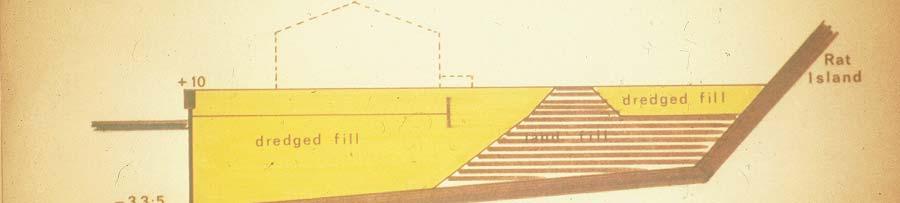
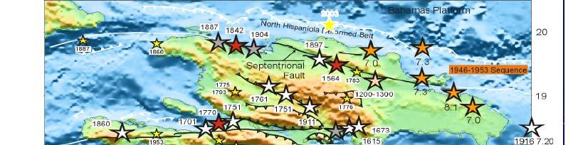
7 History 1967 Caracas Earthquake 1971 Key, Tomblin, Imbert 1974 Antigua Earthquake 1969 SEAOC 1979 First Caribbean Conference on Earthquake Engineering Principia Mechanica 1997 Cariaco and Tobago Tb Earthquakes 2003 Dominican Republic Earthquake EUCENTRE SRC Study 2010 Haiti Earthquake 1967 Caracas Earthquake: soils, non structural infill, overturning 7


8 Photo: David Key 8


9 Photo: Photo: The 09 July 1997 Cariaco Earthquake north-east of Venezuela Photo: Photo: The 09 July 1997 Cariaco Earthquake north-east of Venezuela 9

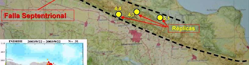
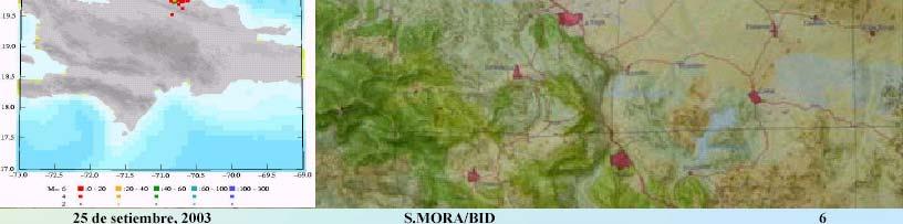

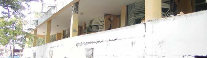
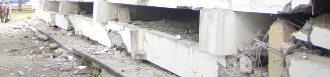
10 The 22 Sep 2003 Earthquake north of Hispañola The 22 Sep 2003 Earthquake north of Hispañola Photo: Daniel Comarazamy 10

11 11

12 12


13 NATIONAL CATHEDRAL Photo: GADR 13
14 World Bank ECCR Workshop in St Vincent 26 January 2012 Photo: Julian Jackson Fuel Port 14

15 Fuel Port 15


, without collapse, but with some structural as well as non structural")
16 Design Philosophy Protect lives rather than property Structures designed in conformance with the provisions and principles i set forth hin CUBiC:Part 2:Section 3 2S i should, in general, be able to: 1 resist minor earthquakes without damage; 2 resist moderate earthquakes without structural damage, but with some non structural damage; 3 resist major earthquakes, of the intensity of severity of the strongest experienced in (the target area), without collapse, but with some structural as well as non structural damage. 16
17 Concrete Behavior A sp f yh A sp d s f yh A sp Confinement from spiral or circular hoop Forces acting on 1/2 spiral or circular hoop Confinement from square hoop Column with spiral reinforcement 17


18 Column with inadequate ties Wind Loads and Design Provisions 18
19 CP3 Chapter V:Part mph 1 minute average (= 93 mph or 41 m/s 3 second gust) Rudimentary procedures South Florida Building Code 1960s 120 mph fastest mile (= 137 mph or 61 m/s 3 second gust) Rudimentary procedures 19
20 The Council of Caribbean Engineering Organisations (CCEO) 1969 gave a mandate to the Barbados Association of Professional Engineers (BAPE) to prepare a wind load standard, AR Matthews, HC Shellard Wind Loads for Structural t Design 1970 including HC Shellard HC Shellard Extreme Winds in the Commonwealth Caribbean 20
21 Our first modern standard Based on the approach of the 1972 edition of the British Standard CP 3:Chapter V:Part 2 (also the guide for the 1970s Australian standard and the Brazilian standard) Over 80 pages: o procedures o extensive range of pressure and force coefficients i o several appendices of explanatory background to the procedures the suitable textbook of fundamentals Basic wind speed V (3 second, 33 ft, 50 year, open terrain) Topographic factor S1 Terrain roughness, height, size S2 Importance S3 Design wind speed VS = V x S1 x S2 x S3 Pressures derived from VS 21
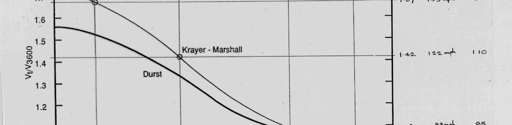
22 Durst-Deacon 22

 St Lucia, St Vincent 120")
 Trinidad 90 (= 40 m/s)")
23 Suggested Basic Wind Speeds (mph, 3s) for Some Commonwealth Caribbean Countries 1970 Jamaica 120 (= 54 m/s) BVI 120 (= 54 m/s) Leeward Islands 120 (= 54 m/s) St Lucia, St Vincent 120 (= 54 m/s) Barbados 120 (=54 m/s) Grenada, Tobago 100 (= 45 m/s) Trinidad 90 (= 40 m/s) Guyana 50 (= 22 m/s) 23
24 1981 Revision of Wind Loads for Structural Design (3s) CCEO BAPE NCST OAS HE Browne BA Rocheford Procedures for aerodynamically sensitive structures (< 1Hz) Jamaica 56 m/s (= 125 mph) BVI 64 m/s (= 143 mph) Leeward Islands 64 m/s (= 143 mph) St Lucia, Dominica 58 m/s (= 130 mph) Barbados, St Vincent 58 m/s (= 130 mph) Grenada, Tobago 50 m/s (= 112 mph) Trinidad 45 m/s (= 101 mph) Guyana 22 m/s (= 49 mph) BA Rocheford (Caribbean Meteorological Institute) 1984 Revision of Wind Speeds 10 minute Belize Centre 29.0 m/s (= 65 mph) [= 93 mph 3s] Jamaica N 37.0 m/s (= 83 mph) [= 119 mph 3s] Jamaica S 41.0 m/s (= 92 mph) [= 132 mph 3s] St Kitts 44.5 m/s (= 100 mph) [= 143 mph 3s] Antigua 46.0 m/s (= 103 mph) [= 147 mph 3s] Dominica 41.0 m/s (= 92 mph) [= 132 mph 3s] St Lucia 43.0 m/s (= 96 mph) [= 137 mph 3s] Barbados 42.0 m/s (= 94 mph) [= 134 mph 3s] Tobago 31.5 m/s (= 70 mph) [= 100 mph 3s] Trinidad Central 27.5 m/s (= 62 mph) [= 89 mph 3s] 24
 Davenport Surry Georgiou Simulation of hurricane wind climate")

25 The Caribbean Uniform Building Code (CUBiC:1985) The Boundary Layer Wind Tunnel Laboratory (University of Western Ontario) Davenport Surry Georgiou Simulation of hurricane wind climate using: o drop in barometric pressure; o radius of the ring to maximum wind speeds; o translation speed; o angle of its track; o position of the point of interest relative to the centre of the storm. 25

(C exp )(C shp )(C dyn ) CUBiC")
26 CUBiC:1985 (forerunner of ISO 4354:1997) UWO BLWTL o o Reference pressures (10 minute average wind speeds adjustments for height and ground roughness; shape and size; dynamic response: w = (q ref )(C exp )(C shp )(C dyn ) CUBiC Part 2 Section 2 26
 23")


27 Maximum Wind Speeds (50 year return) 23 N 89.5 W 59 W CDMP knots mph kph m/s 9 N Storm Category Wind Speeds
28 Ir P C van Staalduinen and Dr Ir C P W Geurts TNO (Netherlands Organisation for Applied Scientific Research) Hurricane Hazard in the Netherlands Antilles
29 1999: CARICOM decision to adopt and adapt the I codes of the ICC 2000: The I codes adopt by reference the wind load provisions of the ASCE : PAHO executed a project, funded by USAID for the preparation ofthe Caribbean Application Document (CAD) for ASCE 7 05 Ch 6. The trend for Caribbean standards is to adopt and adapt the ASCE 7 approach (Dominican Republic, new CUBiC, Cayman, Bahamas) 29
30 Wind Hazard Maps for the Caribbean Basin (3 second mph at 33ft) Overall region and individual islands April 2008 Principal researcher Applied Research Associates (Peter Vickery) Regional coordinator (CEP International Ltd) Executing agency Pan American Health Organisation (Dana van Alphen) Funding agency United States Agency for International Development (Tim Callaghan and Julie Leonard) Caribbean Basin Wind Hazard Maps: a series of overall, regional, wind hazard maps using uniform, state of the art approaches covering all of the Caribbean islandsandthe Caribbeancoastal areasof South and Central America. 30


31 Contour plots of modelled minimum central pressures (mbar) 50 year return period. Contours represent the minimum pressure anywhere within 250 km of a point 50 Year Wind Speeds for Caribbean
32 100 Year Wind Speeds for Caribbean Year Wind Speeds for Caribbean
33 1700 Year Wind Speeds for Caribbean
34 34
35 35
36 36
37 Location Return period (years) Peak gust wind speeds (mph) in flat open terrain as a function of return period for selected locations in the Caribbean Trinidad (S) Trinidad (N) Isla Margarita Grenada Bonaire Curacao Aruba Barbados Saint Vincent Saint Lucia Martinique Dominica Guadeloupe Montserrat St. Kitts and Nevis Antigua and Barbuda Saint Martin/Sint Maarten Anguilla US Virgin Islands British Virgin Islands Grand Cayman Little Cayman/Cayman Brac Turks & Caicos (Grand Turk) Turks & Caicos (Providenciales) Eleuthera Andros New Providence (Nassau) Great Abaco Grand Bahama (Freeport) Belmopan miles per hour Wind Load Factor Non-Hurricane Hurricane Return Period (Years) Wind load factor (V T /V 50 ) 2 for Hurricane and Non Hurricane Wind Speeds plotted vs return period 37


")
38 Wind Load Factor Non-Hurricane Hurricane Return Period (Years) Contour plots of (V 700 /V 50 ) 2 38
39 World Bank ECCR Workshop in St Vincent 26 January Contour plots of importance factor for ASCE category III and IV structures defined by I=(V 1700 /V 700 ) 2 o o o o ASCE 7Basic Wind Speed, V 3 sec, 33 ft height, Exposure C, 50 years For same level of safety in the Caribbean a pseudo 50 year wind speed = V 700/ 1.6 must be used instead of the real V 50. Alternatively the real V 50 could be used with an upward adjustments to the Load Factors and Importance Factors. Alternatively, the Basic Wind Speed could be taken y, p as V 700 for Category II buildings and V 1700 for Categories III and IV buildings, with the Load Factor and Importance Factor = 1. This last approach will be simpler in a regional context. 39
40 The 700 year Return Period: 1 50 year return period for non hurricane areas 2 Load factor = Failure load produced by 50 year wind speed x Use 700 year wind with load factor of 1 Load Combinations (factored loads using strength design) 1: 1.4(D + F) 2: 1.2(D + F + T ) + 1.6(L + H) + 0.5(Lr or S or R) 3: 1.2D + 1.6(Lr or S or R) + (L or 0.8W) 3a: 1.2D + 1.6(Lr or R) + (L or 0.8W700/1.6) 4: 1.2D + 1.6W + L + 0.5(Lr or S or R) 4a: 1.2D + 1.0W700 + L + 0.5(Lr or R) 5: 1.2D + 1.0E + L + 0.2S 6: 0.9D + 1.6W + 1.6H 6a: 0.9D + 1.0W H 7: 0.9D + 1.0E + 1.6H 40
41 SYMBOLS AND NOTATION D = dead load Di = weight of ice E = earthquake load F = load due to fluids with well defined pressures and maximum heights Fa = flood load H = load due to lateral earth pressure, ground water pressure, or pressure of bulk materials L = live load Lr = roof live load R = rain load S = snow load T = self straining force W = wind load Wi = wind on ice determined in accordance with Chapter 10 Load Combinations (nominal loads using allowable stress design) 1: D + F 2: D + H + F + L + T 3: D + H + F + (Lr or S or R) 4: D + H + F (L + T ) (Lr or S or R) 5: D + H + F + (W or 0.7E) 5a: D + H + F + (W700/1.6 or 0.7E) 6: D+H+F+0.75(W or 0.7E)+0.75L+0.75(Lr 0 0 5( or S or R) 6a: D+H+F+0.75(W700/1.6 or 0.7E)+0.75L+0.75(Lr or R) 7: 0.6D + W + H 7a: 0.6D + W700/1.6 + H 8: 0.6D + 0.7E + H 41
42 ASCE 7 was written for the USA which h has a mixture it of hurricaneprone regions and non hurricane regions. The CAD will eliminate all references to non hurricane regions. ASCE 7 allows three methods for determining i wind dforces on structures: Method 1: Simplified (tables & limited use) Method 2: Analytical (almost all cases) Method 3: Wind Tunnel (unusual cases) 42
43 Method 1: Simplified The building must be: 1. a simple diaphragm building; 2. a low rise building; 3. enclosed and conform to the wind borne debris provisions; 4. a regular shaped building or structure; 5. not classified as a flexible building; 6. not assessed as having unfavourable aerodynamic characteristics and not having an unfavourable site location; 7. of a structure with no expansion joints or separations; 8. not subject to unfavourable topographic effects; 9. of an approximately symmetrical cross section. Method 2: Analytical The Design Procedure requires the following steps: 1. basic wind speed V and wind directionality factor K d 2. importancefactor I 3. exposure category or exposure categories and velocity pressure exposure coefficient K z or K h 4. topographic factor K zt 5. gust effect factor G or G f, 6. enclosure classification 7. Internal pressure coefficient Gc pi 8. External pressure coefficients C p or GC pf, or force coefficients C f 9. Velocity pressure q z or q h, 10. Design wind load p or F 43
44 o o o A lengthy process but, ASCE 7 provides most of the answers in tables and figures. A growing reliance on proprietary software for the use of computers in the determination of wind forces The negative effect of reducing the understanding of engineers in the fundamentals of wind forces on structures more likely that gross errors would occur There is debate over the wind directionality factor K d where it is applied to round chimneys and similar shaped structures. (See Rolando Vega s paper.) 44
45 The penalties in the form of increased loads for buildings without impactresistant glazing or impact resistant, permanently installed shutters are severe. This should provide significant impetus for owners, designers and builders to incorporate impact resistant windows or shutters in buildings. o o o Topographic effects are very important in most Caribbean countries. This issue receives attention in ASCE 7. Wind speed up is recognised over hills, ridges, and escarpments. Valleys are missing. 45


46 Photo: UWO BLWTL Sketch showing effects of topography on wind velocity on a hilly island V g 100 Speed up V s 120 V g 100 V g 100 Vg 100 V m s V s Open sea Winward Speed up over Sheltered leeward Coast hill crest coast 46


47 Winds N Probability 1% / year, 100-Year Return Time Antigua 1. St. John s Downtown East side of town 47 m/s 51 m/s 2. Parham Desalinization plant 50 m/s Wt Waterfront tby town 47 m/s Hill above town 53 m/s 3. English and Falmouth Harbours Nelson s Dockyard 48 m/s Falmouth SE 41 m/s Falmouth NW 52 m/s 4. Jolly Harbour Channel entrance Inner boat basin Beach front 45 m/s 44 m/s 45 m/s W Ross Wagenseil for PGDM April W Directory Topo. Map 10yr 25yr 50yr 100yr Wind Wave Surge AR RC-MINUTES KILOMETERS N MILES Storm Category knots mph m/s N Wind Speeds 3 PGDM May Min Max Winds N CDMP 100-Year Return Time 72 W Dominican Republic 68 W DEGREES MILES KIL LOMETERS N 17.5 N Ross Wagenseil for CDMP January Storm Category knots mph kph m/s Wind Speeds Return to Directory Wind Wave Surge 10yr 25yr 50yr 100yr West Basin Mid- Basin Caribbean East Basin 47
 z V(z) x (windward) V(z) H/2 H speed up x (leeward) L m H/2 L m H/2 Hill Escarpment")
48 Risk Management Solutions Topographic effect showing wind velocity increase z z z V(z) x (windward) V(z) H/2 H speed up x (leeward) z V(z) x (windward) V(z) H/2 H speed up x (leeward) L m H/2 L m H/2 Hill Escarpment 48


49 Pre-Ivan photograph by Brooks La Touche Pre Ivan photograph by Brooks La Touche 49


50 Photo: The National Stadium Method 3 Wind Tunnel Procedure o o Wind tunnel testing is no longer unknown in the design of Caribbean buildings. Used for: overall loads on the main wind force resisting systems; pressures on external cladding; pedestrian conditions adjacent to buildings. 50


 Guyana (?")
51 Present Standards and Codes CUBiC and national codes Barbados Belize OECS (9 states) Bahamas South Florida Building Code Cayman Southern Building Code Congress International TCI hybrid (USA and CUBiC) Guyana (?) Jamaica (IBC) Trinidad & Tobago (in preparation) 51
52 The New CUBiC (or CUBiS) to be based on the IBC CUBiS countries: Barbados Belize Guyana Jamaica Trinidad & Tobago OECS (9 states) Othersimilar countries Bahamas SFBC >> IBC Cayman SBCCI >> IBC TCI hybrid >> IBC Dominican Republic >> IBC approach Components (agreed by CCEO & CARICOM in March 1999) 1 Caribbean Application Document (CAD) based on IBC 2 Caribbean Residential Design Standards 3 Model Laws and Regulations 52
53 Components 1 Caribbean Application Document (CAD) based on IBC a Use IBC 200? (The soon to be published version is 2006.) b Delete clauses?? c Amend clauses?? by replacing them with d Add clauses as follows: Components 2 Caribbean Residential i lstandards d a b c Not necessarily based on IRC 200? Consistent with the CAD Prescriptive and necessarily more conservative than CAD 53
54 Components 3 ModelLaws and Regulations a Each Caribbean state may wish to have its own laws and regulations. b It would be desirable if there were similarities of approach and content. Country Standards Laws Enforcement Status Anguilla Y Y Y Antigua Y Y Y? Bahamas Y Y Y Barbados Y N N Belize Y N N BVI Y Y Y? Cayman Y Y Y Dominica Y Y? N Grenada Y Y Y? Guyana N N N Jamaica Y Y Y Montserrat Y Y Y St Kitts Y Y Y? St Lucia Y N N St Vincent Y N N TCI Y Y Y Trinidad N Y Y 54


55 AMO = Atlantic multi decadal oscillations 55


56 NAtl = North Atlantic The Impact of Climate Change on Design Wind Speeds in Saint Lucia 2008 Peter J. Vickery 56
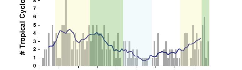
57 Percentage Increase in Basic Wind Speed in Lucia vs. Percentage Increase in Annual Rates of Category 4 and 5 Hurricanes 15% Increase in Basic Wind Speed 10% 5% Category II Buildings Category III and IV Buildings 113 0% 0% 50% 100% 150% 200% 250% 300% 350% Projections According to Curry et al. (2007), there could be an average of three to four Category4 and 5 hurricanes per year by 2025in the Atlantic Basin. This represents a 210 to 280 percent increase in the number of Category 4 and 5 hurricanes compared to the long term ( ) average of 1.4 Category 4 and 5 hurricanes per year. If this were the case, the basic wind speeds for Category II buildings in Saint Lucia should be increased by about 12 to 14 percent, and the basic wind speeds for Category III and IV buildings should be increase by about 10 percent. Note that the increases in the basic wind speeds assume that the hurricane hazard remains elevated for the expected life of the building
Caribbean Application Document for ASCE 7-05 Chapter 6 Wind Loads with references to Chapter 1 General and Chapter 2 Combinations of Loads
 Caribbean Application Document for ASCE 7-05 Chapter 6 Wind Loads with references to Chapter 1 General and Chapter 2 Combinations of Loads The Standard ASCE 7 is the American Society of Civil Engineers:
The Wind Speeds in Selected Islands During Hurricanes Irma and Maria in 2017 compiled by Tony Gibbs FREng
 The Wind Speeds in Selected Islands During Hurricanes Irma and Maria in 2017 compiled by Tony Gibbs FREng Structural failures leading to serious damage or collapse, or those severely affecting the use
Design Wind Speeds for the Caribbean for use with the Wind Load Provisions of ASCE 7
 Design Wind Speeds for the Caribbean for use with the Wind Load Provisions of ASCE 7 Prepared by Peter J Vickery and Dhiraj Wadhera Applied Research Associates 854 Colonnade Center Drive, Suite 37 Raleigh,
THE UNIVERSITY OF THE WEST INDIES MONA CAMPUS TOTAL NUMBER OF GRADUATES - OFF-CAMPUS BY FACULTY, COUNTRY AND SEX, 2007
 TABLE 49 TOTAL NUMBER OF - OFF-CAMPUS ANGUILLA M F T M F T M F T M F T M F T M F T 0 0 0 0 1 1 0 0 0 0 0 0 0 0 0 0 1 1 ANTIGUA & BARBUDA 0 0 0 0 0 0 0 0 0 0 1 1 0 0 0 0 1 1 BAHAMAS 1 0 1 0 0 0 0 0 0 0
Climate Change Impacts and Adaptation for Coastal Transport Infrastructure in Caribbean SIDS
 UNCTAD National Workshop Saint Lucia 24 26 May 2017, Rodney Bay, Saint Lucia Climate Change Impacts and Adaptation for Coastal Transport Infrastructure in Caribbean SIDS Impacts of Natural Hazards on the
Caribbean Tropical Cyclone Modeling
 Caribbean Tropical Cyclone Modeling Filmon Habte, PhD 2018 RAA Catastrophe Risk Management Conference Orlando, Florida February 14, 2018 Agenda Hurricane risk in the Caribbean 2017 hurricane season Lessons
ASSOCIATION OF CARIBBEAN STATES (ACS / AEC)
") ASSOCIATION OF CARIBBEAN STATES (ACS / AEC) 1 SHOCS (Strengthening Hydrometorological Operations and Services in Caribbean SIDS) The ACS/Finnish Government response to Hydrometorological risk in Caribbean
ASSOCIATION OF CARIBBEAN STATES (ACS / AEC) 1 SHOCS (Strengthening Hydrometorological Operations and Services in Caribbean SIDS) The ACS/Finnish Government response to Hydrometorological risk in Caribbean
GEONETCast Future Plans at CIMH
 GEONETCast Future Plans at CIMH Operations, Training, Climate Monitoring and Disaster Preparedness WORLD METEOROLOGICAL ORGANIZATION COORDINATION GROUP ON SATELLITE DATA REQUIREMENTS FOR REGION III AND
Tropical Storm Isaac. INFORMATION NOTE No. 3 AS OF 8:00 PM (AST) ON SEPTEMBER 12, Synopsis of Tropical Storm Isaac
 ON SEPTEMBER 12, Synopsis of Tropical Storm Isaac") Synopsis of Tropical Storm Isaac LOCATION: 260 MILES EAST NORTH EAST OF MARTINIQUE PRESENT MOVEMENT: WEST AT 20 MPH MAXIMUM SUSTAINED WINDS: 60 MPH MINIMUM CENTRAL PRESSURE: 1003 MB WATCHES AND WARNINGS
Synopsis of Tropical Storm Isaac LOCATION: 260 MILES EAST NORTH EAST OF MARTINIQUE PRESENT MOVEMENT: WEST AT 20 MPH MAXIMUM SUSTAINED WINDS: 60 MPH MINIMUM CENTRAL PRESSURE: 1003 MB WATCHES AND WARNINGS
Climate Change Impacts and Adaptation for Coastal Transport Infrastructure in Caribbean SIDS
 UNCTAD National Workshop Jamaica 30 May 1 June 2017, Kingston, Jamaica Climate Change Impacts and Adaptation for Coastal Transport Infrastructure in Caribbean SIDS Impacts of Natural Hazards on the Transport
Covered Area Rainfall Event (29-30 September 2016) Tropical Cyclone Matthew Excess Rainfall
 Tropical Cyclone Matthew Excess Rainfall") Covered Area Rainfall Event (29-30 September 2016) Tropical Cyclone Matthew Excess Rainfall Event Briefing Dominica 11 October 2016 Registered Office: c/o Sagicor Insurance Managers Ltd., 103 South Church
Covered Area Rainfall Event (29-30 September 2016) Tropical Cyclone Matthew Excess Rainfall Event Briefing Dominica 11 October 2016 Registered Office: c/o Sagicor Insurance Managers Ltd., 103 South Church
CARIBBEAN TOURISM CLIMATIC BULLETIN
 A Joint Bulletin of the CTO, the CHTA and the CIMH CARIBBEAN TOURISM CLIMATIC BULLETIN for Tourism Businesses and Policymakers May 2017 Vol I Issue 1 Photo Credit:pixabay.com Purpose This bulletin is a
Disaster Risk Assessment: Opportunities for GIS and data management with Open DRI
 Disaster Risk Assessment: Opportunities for GIS and data management with Open DRI Jacob Opadeyi Department of Geomatics Engineering and Land Management, The University of the West Indies, St. Augustine,
Macroeconomic implications of natural disasters on small economies
 Macroeconomic implications of natural disasters on small economies Sebastian Acevedo IMF Western Hemisphere Department Central Bank of Curaçao and Sint Maarten March 22, 2018 Disclaimer: The views expressed
CARIBBEAN TOURISM CLIMATIC BULLETIN
 A Joint Bulletin of the CTO, the CHTA and the CIMH CARIBBEAN TOURISM CLIMATIC BULLETIN for Tourism Businesses and Policymakers Sept-Oct-Nov 2018 I Vol 2 I Issue 3 Photo Credit: Cayman Islands Department
INTERNATIONAL HYDROGRAPHIC ORGANIZATION MESO AMERICAN & CARIBBEAN SEA HYDROGRAPHIC COMMISSION
 INTERNATIONAL HYDROGRAPHIC ORGANIZATION MESO AMERICAN & CARIBBEAN SEA HYDROGRAPHIC COMMISSION CAPACITY BUILDING PLAN Programme document for the period 2010-2012 1. INTRODUCTION 1.1. Rationale It is estimated
Covered Area Rainfall Event (18-19 September 2017) Hurricane Maria Excess Rainfall
 Hurricane Maria Excess Rainfall") Covered Area Rainfall Event (18-19 September 2017) Hurricane Maria Excess Rainfall Event Briefing Barbados 28 September 2017 Registered Office: CCRIF SPC c/o Sagicor Insurance Managers Ltd., 198 North
Covered Area Rainfall Event (18-19 September 2017) Hurricane Maria Excess Rainfall Event Briefing Barbados 28 September 2017 Registered Office: CCRIF SPC c/o Sagicor Insurance Managers Ltd., 198 North
Wind Engineering in the Caribbean Disaster Mitigation Project
 Wind Engineering in the Caribbean Disaster Mitigation Project Tony Gibbs 1 Abstract The Caribbean Disaster Mitigation Project (CDMP) lasted for 6 years (1993-99). It was funded by USAID and managed by
UN-GGIM:Americas Regional Report
 UN-GGIM:Americas Regional Report 2016-2017 Seventh Session of UN-GGIM 2-4 August 2017, United Nations Headquarters, New York. Rolando Ocampo President of UN-GGIM: Americas Content Activities, Areas of
Covered Area Rainfall Event (28-30 September 2016) Tropical Cyclone Matthew Excess Rainfall
 Tropical Cyclone Matthew Excess Rainfall") Covered Area Rainfall Event (28-30 September 2016) Tropical Cyclone Matthew Excess Rainfall Event Briefing St. Vincent & the Grenadines 11 October 2016 Registered Office: c/o Sagicor Insurance Managers
Covered Area Rainfall Event (28-30 September 2016) Tropical Cyclone Matthew Excess Rainfall Event Briefing St. Vincent & the Grenadines 11 October 2016 Registered Office: c/o Sagicor Insurance Managers
WEATHER SYSTEMS IMPACTING THE CAYMAN ISLANDS Prepared by the staff of the Cayman Islands National Weather Service
 WEATHER SYSTEMS IMPACTING THE CAYMAN ISLANDS 2008 Prepared by the staff of the Cayman Islands National Weather Service TROPICAL STORM DOLLY Formed 194 miles west of Grand Cayman July 19 th. The tropical
Hurricane Basics and Preparedness. Jim Weyman Director, Central Pacific Hurricane Center Phone Office:
 Hurricane Basics and Preparedness Jim Weyman Director, Central Pacific Hurricane Center Phone Office: 973-5270 james.weyman@noaa.gov United States Hurricane/Typhoon Centers National Hurricane Center, Miami
Climate Change Impacts and Risks: The Challenge for Caribbean Ports. STC-13, April Georgetown, Guyana
 Climate Change Impacts and Risks: The Challenge for Caribbean Ports STC-13, April 15-18 Georgetown, Guyana Leonard A. Nurse, PhD CERMES, Faculty of Pure and Applied Sciences University of the West Indies
The Circle of Learning
 The Circle of Learning Title: Theme: Subject: Tracking the Storm Weather Predictions Mathematics Overview: Severe weather can have devastating effects on people and the communities in which they live.
Cambridge International Examinations Cambridge Ordinary Level
 Cambridge International Examinations Cambridge Ordinary Level *0607581492* GEOGRAPHY 2217/13 Paper 1 October/November 2018 1 hour 45 minutes Candidates answer on the Question Paper. Additional Materials:
Disaster Risk Management in India. Kamal Kishore New Delhi, 27 October 2016
 Disaster Risk Management in India Kamal Kishore New Delhi, 27 October 2016 Hazard, Exposure and Vulnerability Disaster Prevention Mitigation Hurricane Matthew: Cuba & Haiti Emergency Response Coordination
Tropical Cyclone Harvey (AL092017)
") Tropical Cyclone Harvey (AL092017) Wind and Storm Surge Preliminary Event Briefing Windward Islands 20 August 2017 Registered Office: CCRIF SPC c/o Sagicor Insurance Managers Limited, 198 North Church
Tropical Cyclone Harvey (AL092017) Wind and Storm Surge Preliminary Event Briefing Windward Islands 20 August 2017 Registered Office: CCRIF SPC c/o Sagicor Insurance Managers Limited, 198 North Church
ARUBA CLIMATOLOGICAL SUMMARY 2017 PRECIPITATION
 ARUBA CLIMATOLOGICAL SUMMARY 2017 PRECIPITATION The total amount of rainfall recorded at Reina Beatrix International Airport for the year 2017 was 391.0 mm. This is 17.1 % below normal ( Figure 1 ). During
Hurricane Matthew Page 1 Location Forecast Analysis Summary Report - Advanced Wind Estimation On
 Page 1 Current NHC Forecast Predictions Maximum Sustained Winds / Storm Category: 138 MPH / Category 4 Forward motion: 9 mph towards the North Hurricane Force winds extend from the center: 46 miles Tropical
STATUS OF HAZARD MAPS VULNERABILITY ASSESSMENTS AND DIGITAL MAPS
 JapanInternational Cooperation Agency STATUS OF HAZARD MAPS VULNERABILITY ASSESSMENTS AND DIGITAL MAPS ANGUILLA REPORT THE CARIBBEAN DISASTER EMERGENCY RESPONSE AGENCY () Table of Contents Page Preface
A pluralistic approach to EBM implementation in the Caribbean.
 A pluralistic approach to EBM implementation in the Caribbean. Lucia Fanning Marine Affairs Program Dalhousie University AORAC-SA FAO workshop: Making the ecosystem approach operational 20-22 January 2016
Bridge Risk Modeling
 time good Bridge Risk Modeling Current Florida DOT Research condition bad Paul D. Thompson, Consultant Background Research team Florida State University John Sobanjo (PI) Paul D. Thompson (co-pi) Florida
Strategic Framework on Geospatial Information and Services for Disasters Relevance for the Americas Region
 Strategic Framework on Geospatial Information and Services for Disasters Relevance for the Americas Region Seventh Session of the Committee of Experts on UN-GGIM Side Event --- UN Headquarters, New York
Climate Change and Water: What s the future of Caribbean Agriculture?
 Climate Change and Water: What s the future of Caribbean Agriculture? Presented by: Adrian Trotman CAMI Project Manager Chief, Applied Meteorology and Climatology Caribbean Institute for Meteorology and
2018 WFCM Changes. Wood Frame Construction Manual for One- and Two-Family Dwellings (STD350)
") 2018 WFCM Changes Wood Frame Construction Manual for One- and Two-Family Dwellings (STD350) John Buddy Showalter, P.E. Vice President, Technology Transfer American Wood Council Lori Koch, P.E. Manager,
2018 WFCM Changes Wood Frame Construction Manual for One- and Two-Family Dwellings (STD350) John Buddy Showalter, P.E. Vice President, Technology Transfer American Wood Council Lori Koch, P.E. Manager,
Weather Observing and Forecasting and the Hurricane Warning System in the Caribbean
 T.W. Sutherland: Weather Observing and Forecasting and the Hurricane Warning System in the Caribbean 6 ISSN 1000 7924 The Journal of the Association of Professional Engineers of Trinidad and Tobago Vol.42,
Effectiveness of Disaster Risk Reduction (DRR) programs funded by ECHO in the Caribbean
 programs funded by ECHO in the Caribbean") Effectiveness of Disaster Risk Reduction (DRR) programs funded by ECHO in the Caribbean Evidence collected after hurricanes Irma and Maria 1 Introduction The 2017 hurricane season has been exceptionally
Effectiveness of Disaster Risk Reduction (DRR) programs funded by ECHO in the Caribbean Evidence collected after hurricanes Irma and Maria 1 Introduction The 2017 hurricane season has been exceptionally
After 2017 Is the Future Predictable?
 After 2017 Is the Future Predictable? Presented by: Evan Thompson Director, Meteorological Service, Jamaica At Caribbean Insurance Conference, Montego Bay, Jamaica June 4, 2018 What s Happening with the
What s New In ASCE 7-16?
 What s New In ASCE 7-16? Ronald O. Hamburger SE, SECB Senior Principal Simpson Gumpertz & Heger Inc. Presented to: TMS San Diego, CA Nov. 4 2017 www.sgh.com The Big Changes Title Change Chapter 1 Performance
WEDNESDAY 30 TH AUGUST, :57 p.m. Tropical Storm Irma forms in the Atlantic. Don t let your guard down, always #Be Ready.
 Chapter 1 - The Set Up In the days leading up to Irma a series of composed and sobering text messages, presented in truncated form below, from Department of Disaster Management warned us of the pending
User s Guide to Storm Hazard Maps and Data
 Storm Hazard Assessment for St. Lucia and San Pedro/Ambergris Caye, Belize User s Guide to Storm Hazard Maps and Data Prepared For: Caribbean Development Bank Advanced technology and analysis solving problems
Tropical Cyclone Sandy (AL182012)
") Tropical Cyclone Sandy (AL182012) Event Briefing Caribbean Risk Managers Ltd Facility Supervisor 29 October 2012 Facility Supervisor: Caribbean Risk Managers Ltd Email: ccrif@ccrif.org Tel (Barbados):
Tropical Cyclone Sandy (AL182012) Event Briefing Caribbean Risk Managers Ltd Facility Supervisor 29 October 2012 Facility Supervisor: Caribbean Risk Managers Ltd Email: ccrif@ccrif.org Tel (Barbados):
About the Authors Geography and Tourism: The Attraction of Place p. 1 The Elements of Geography p. 2 Themes of Geography p. 4 Location: The Where of
 Preface p. ix About the Authors p. xi Geography and Tourism: The Attraction of Place p. 1 The Elements of Geography p. 2 Themes of Geography p. 4 Location: The Where of Geography p. 4 Place and Space:
Comparative Analysis of Hurricane Vulnerability in New Orleans and Baton Rouge. Dr. Marc Levitan LSU Hurricane Center. April 2003
 Comparative Analysis of Hurricane Vulnerability in New Orleans and Baton Rouge Dr. Marc Levitan LSU Hurricane Center April 2003 In order to compare hurricane vulnerability of facilities located in different
Current Details from the National Hurricane Center (NHC)
") Current Watches and Warnings A Hurricane Warning is in effect for U.S. Virgin Islands; British Virgin Islands; Puerto Rico, Culebra, and Vieques; Dominican Republic from Cabo Engano to Puerto Plata; Turks
Current Watches and Warnings A Hurricane Warning is in effect for U.S. Virgin Islands; British Virgin Islands; Puerto Rico, Culebra, and Vieques; Dominican Republic from Cabo Engano to Puerto Plata; Turks
RNR 516A. Computer Cartography. Spring GIS Portfolio
 RNR 516A Computer Cartography Spring 2016 GIS Portfolio 1 Contents 1 Political and Locator Maps 3 2 Base Maps and Digitizing 4 3 Data Entry Report 5 4 Projections and Symbolization 6 5 Choropleth Mapping
Tropical Cyclone Gonzalo (AL082014)
") Tropical Cyclone Gonzalo (AL082014) Event Briefing 20 October 2014 Registered Office: c/o Sagicor Insurance Managers Ltd., 103 South Church Street 1st Floor Harbour Place, P.O. Box 1087, Grand Cayman KY1-1102,
Tropical Cyclone Gonzalo (AL082014) Event Briefing 20 October 2014 Registered Office: c/o Sagicor Insurance Managers Ltd., 103 South Church Street 1st Floor Harbour Place, P.O. Box 1087, Grand Cayman KY1-1102,
Multi Hazard Evaluation of a High Voltage Transmission Network. John Eidinger 1 and Leon Kempner 2
 Multi Hazard Evaluation of a High Voltage Transmission Network John Eidinger 1 and Leon Kempner 2 1 G&E Engineering Systems Inc., P. O. Box 3592 Olympic Valley, CA 96146-3592; eidinger@earthlink.net. 2
HURRICANE CHARLEY CHARACTERISTICS and STORM TIDE EVALUATION
 HURRICANE CHARLEY CHARACTERISTICS and STORM TIDE EVALUATION By Robert Wang, Michael Manausa And Jenny Cheng Sponsored by Florida Department of Environmental Protection, Bureau of Beaches and Coastal Systems
AnuMS 2018 Atlantic Hurricane Season Forecast
 AnuMS 2018 Atlantic Hurricane Season Forecast : June 11, 2018 by Dale C. S. Destin (follow @anumetservice) Director (Ag), Antigua and Barbuda Meteorological Service (ABMS) The *AnuMS (Antigua Met Service)
Experiences on Data and Observational Requirements in the Caribbean
 Experiences on Data and Observational Requirements in the Caribbean UNFCCC Expert Workshop on Methods & Tools and on Data & Observations under the NWP on Impacts, Vulnerability & Adaptation to Climate
AnuMS 2018 Atlantic Hurricane Season Forecast
 AnuMS 2018 Atlantic Hurricane Season Forecast Issued: April 10, 2018 by Dale C. S. Destin (follow @anumetservice) Director (Ag), Antigua and Barbuda Meteorological Service (ABMS) The *AnuMS (Antigua Met
The AIR Tropical Cyclone Model for Mexico
 The AIR Tropical Cyclone Model for Mexico In September 214, Hurricane Odile made landfall near Cabo San Lucas, Mexico, as a Category 3 hurricane, then moved up the center of Baja California, bringing strong
Future climate change in the Antilles: Regional climate, tropical cyclones and sea states
 Future climate change in the Antilles: Regional climate, tropical cyclones and sea states Ali Belmadani Météo-France Antilles-Guiana (DIRAG), Martinique Acknowledgements: P. Palany, R. Pilon, F. Chauvin,
The Joplin Tornado: Lessons Learned from the NIST Investigation
 February 4, 2014 AMS Annual Meeting The Joplin Tornado: Lessons Learned from the NIST Investigation Franklin T. Lombardo, NIST Erica Kuligowski, NIST Marc Levitan, NIST Long Phan, NIST David Jorgensen,
HURRICANE JEANNE CHARACTERISTICS and STORM TIDE EVALUATION
 HURRICANE JEANNE CHARACTERISTICS and STORM TIDE EVALUATION ((DRAFT)) By Robert Wang and Michael Manausa Sponsored by Florida Department of Environmental Protection, Bureau of Beaches and Coastal Systems
Ensuring the Building of Community Resiliency through Effective Partnership December 4, 2017 Melia Nassau Beach Valentino A. Hanna
 Ensuring the Building of Community Resiliency through Effective Partnership December 4, 2017 Melia Nassau Beach Valentino A. Hanna Sol Caribbean Presence What Occurred Mega Storms 2017 Cat 5 Hurricane
Tropical Cyclone Joaquin (AL112015)
") Tropical Cyclone Joaquin (AL112015) Wind and Storm Surge Event Briefing 9 October 2015 Vito Alessio Robles No.179. Col. Hda Gpe Chimalistac. Del. Álvaro Obregón. Cp 01050, México D.F. Tel: +52 (55) 5616-8161,
Tropical Cyclone Joaquin (AL112015) Wind and Storm Surge Event Briefing 9 October 2015 Vito Alessio Robles No.179. Col. Hda Gpe Chimalistac. Del. Álvaro Obregón. Cp 01050, México D.F. Tel: +52 (55) 5616-8161,
Wind Tower Deployments and Pressure Sensor Installation on Coastal Houses Preliminary Data Summary _ Sea Grant Project No.
 Wind Tower Deployments and Pressure Sensor Installation on Coastal Houses Preliminary Data Summary _ Sea Grant Project No.:1020040317 Submitted to: South Carolina Sea Grant Consortium 287 Meeting Street
Development of Design Wind Speed Maps for the Caribbean for Application with the Wind Load Provisions of ASCE 7
 Development of Design Wind Speed Maps for the Caribbean for Application with the Wind Load Provisions of ASCE 7 Area on Emergency Preparedness and Disaster Relief Coordination 525 23 rd Street, N.W. Washington,
An Environmental Profile of the Island of Jost Van Dyke, British Virgin Islands
 An Environmental Profile of the Island of Jost Van Dyke, British Virgin Islands Executive Summary including Little Jost Van Dyke, Sandy Cay, Green Cay and Sandy Spit This publication was made possible
Hurricane Florence. This bulletin is being issued for information only; it reflects the current situation and details available at this time.
 Information Bulletin Americas: Tropical Depression Isaac and Hurricane Florence Information Bulletin N 3 Date of issue: 14 September 2018 Date of disaster: Ongoing since 6 September 2018 Point of contact:
Why data? Climate Monitoring, Sectoral Applications and More
 Why data? Climate Monitoring, Sectoral Applications and More Part 2 Adrian R. Trotman Chief, Applied Meteorology and Climatology Caribbean Institute for Meteorology and Hydrology CAMI Funded by the European
(April 7, 2010, Wednesday) Tropical Storms & Hurricanes Part 2
 Tropical Storms & Hurricanes Part 2") Lecture #17 (April 7, 2010, Wednesday) Tropical Storms & Hurricanes Part 2 Hurricane Katrina August 2005 All tropical cyclone tracks (1945-2006). Hurricane Formation While moving westward, tropical disturbances
Lecture #17 (April 7, 2010, Wednesday) Tropical Storms & Hurricanes Part 2 Hurricane Katrina August 2005 All tropical cyclone tracks (1945-2006). Hurricane Formation While moving westward, tropical disturbances
Spatial and temporal variability of tropical storm and hurricane strikes in the Bahamas, and the Greater and Lesser Antilles
 Louisiana State University LSU Digital Commons LSU Master's Theses Graduate School 2007 Spatial and temporal variability of tropical storm and hurricane strikes in the Bahamas, and the Greater and Lesser
The Joplin Tornado: Lessons Learned from the NIST Investigation
 February 4, 2014 AMS Annual Meeting The Joplin Tornado: Lessons Learned from the NIST Investigation Franklin T. Lombardo, NIST/RPI Erica Kuligowski, NIST Marc Levitan, NIST Long Phan, NIST David Jorgensen,
What Are Disasters? The Rescue Kids Trio!
 The Rescue Kids Trio! What Are Disasters? This manual was made possible through funding by the Council of Local Authorities for International Relations. Disasters and emergency preparedness Emergency preparedness
LECTURE #17: Severe Weather: Introduction to Hurricanes
 GEOL 0820 Ramsey Natural Disasters Spring, 2018 LECTURE #17: Severe Weather: Introduction to Hurricanes Date: 15 March 2018 I. Hurricane Overview hurricanes o what they are? o how they form? storm stages:
Earthquakes Science & Safety. Dr. Richard Robertson Geologist & Head Seismic Research Unit
 Earthquakes Science & Safety Dr. Richard Robertson Geologist & Head Seismic Research Unit Summary The Eastern Caribbean islands are in a seismically active part of the world. Earthquake safety tips should
17 th Session of RA IV
 17 th Session of RA IV Agenda Item 4.1: Disaster Risk Reduction, Resilience and Prevention, Focusing on Impact-Based Decision Support Services Doc 4.1.(6):Coastal Inundation Forecasting Demonstration Project
AnuMS 2018 Atlantic Hurricane Season Forecast
 AnuMS 2018 Atlantic Hurricane Season Forecast Issued: May 10, 2018 by Dale C. S. Destin (follow @anumetservice) Director (Ag), Antigua and Barbuda Meteorological Service (ABMS) The *AnuMS (Antigua Met
Table S1. Locations and dates of reported sightings of massive pelagic Sargassum strandings in the tropical North Atlantic in 2011.
 Supplemental Content for Franks et al. 2016. Franks, J.S., D.R. Johnson, and D.S. Ko. 2016. Pelagic Sargassum in the tropical North Atlantic. Gulf and Caribbean Research 27:S6-S12. DOI: 10.18785/gcr.2701.08
TRINIDAD AND TOBAGO. Meeting to Enhance State Coordination. MET, AIM, and ATM Fields PRESENTED BY. Between. (Mexico City, Mexico, July 2016)
") TRINIDAD AND TOBAGO Meeting to Enhance State Coordination Between MET, AIM, and ATM Fields (Mexico City, Mexico, 26 28 July 2016) PRESENTED BY Robert Rooplal, ATM Officer Ricky Bissessar, AIM Officer PIARCO
TRINIDAD AND TOBAGO Meeting to Enhance State Coordination Between MET, AIM, and ATM Fields (Mexico City, Mexico, 26 28 July 2016) PRESENTED BY Robert Rooplal, ATM Officer Ricky Bissessar, AIM Officer PIARCO
Tropical Cyclone Isaac (AL092012)
") Tropical Cyclone Isaac (AL092012) Event Briefing, Central Caribbean Impacts Caribbean Risk Managers Ltd Facility Supervisor 27 August 2012 Facility Supervisor: Caribbean Risk Managers Ltd Email: ccrif@ccrif.org
Tropical Cyclone Isaac (AL092012) Event Briefing, Central Caribbean Impacts Caribbean Risk Managers Ltd Facility Supervisor 27 August 2012 Facility Supervisor: Caribbean Risk Managers Ltd Email: ccrif@ccrif.org
STRUCTURAL CALCULATIONS. Example 10 - Sign
 CS09 Ver 10.01.10 www.struware.com STRUCTURAL CALCULATIONS FOR Example 10 - Sign Guide to Wind Load Procedures of ASCE 7-02 Code Search Code: ASCE 7-02 Occupancy: Occupancy Group = B Business Occupancy
photo courtesy of
 BRITISH VIRGIN ISLANDS REPORT TROPICAL STORM JEANNE photo courtesy of www.bviplatinum.com PREPARED BY THE DEPARTMENT OF DISASTER MANAGEMENT 1 EVENT 13 th -16 th September, 2004 TROPICAL STORM JEANNE Sequence
Thursday, September 27, :30 a.m. EDT
 Thursday, September 27, 2018 8:30 a.m. EDT Significant Activity Sep 26-27 Significant Events: Hurricane Florence Response / Recovery Tropical Activity: Atlantic Tropical Storm Kirk; Disturbance 1: High
AN ENGINEERING ASSESSMENT OF STRUCTURAL DAMAGE IN THE ALTUS, OK TORNADO: MAY
 (presented at the 13 th Conference on Severe Local Storms, Tulsa, Oklahoma, October 1983, p. 66-69) AN ENGINEERING ASSESSMENT OF STRUCTURAL DAMAGE IN THE ALTUS, OK TORNADO: MAY 11 1982 1. INTRODUCTION
Characteristics of a Force Loads on Structures. Dead Load. Load Types Dead Live Wind Snow Earthquake. Load Combinations ASD LRFD
 Architecture 314 Structures I Characteristics of a Force Loads on Structures Load Types Dead Live Wind Snow Earthquake Load Combinations ASD LRFD University of Michigan, TCAUP Structures I Slide 1 of 27
ovember 2008 Antigua and Barbuda Meteorological Service
 ovember 2008 Antigua and Barbuda Meteorological Service The Atlantic Hurricane Season Summary 2008 Special Focus on Antigua and Barbuda The Season in Brief Sixteen (16) named storms formed in the Atlantic
NWS HURRICANES June 3, 2015
 NWS HURRICANES June 3, 2015 Hurricane Season June 1 November 30 2 What s the concern? All tropical systems passing within 125nm of central Maryland since 1950 Mid-Atlantic Hurricanes Greatest Risk: August
HURRICANE IRMA SITUATION REPORT #2 AS OF 9:00PM AST ON SEPTEMBER 7, 2017
 HURRICANE IRMA SITUATION REPORT #2 AS OF 9:00PM AST ON SEPTEMBER 7, 2017 Resilience Way, Lower Estate, St. Michael MESSAGE: Powerful category 5 Hurricane Irma continues to impact CDEMA Participating States
AnuMS 2018 Atlantic Hurricane Season Forecast
 AnuMS 2018 Atlantic Hurricane Season : August 12, 2018 by Dale C. S. Destin (follow @anumetservice) Director (Ag), Antigua and Barbuda Meteorological Service (ABMS) The *AnuMS (Antigua Met Service) is
Storm Summary for Hurricane Joaquin
 Storm Summary for Hurricane Joaquin Wednesday, September 30, 2015 at 5 PM EDT (Output from Hurrevac, based on National Hurricane Center Forecast Advisory #12) Joaquin is currently a Category 1 hurricane
CLIMATE CHANGE A THREAT TO THE FUTURE SUSTAINABLE DEVELOPMENT IN THE CARIBBEAN. U Trotz CCCCC
 CLIMATE CHANGE A THREAT TO THE FUTURE SUSTAINABLE DEVELOPMENT IN THE CARIBBEAN 1 Key Observations from the IPCC IV Assessment Temperature trend from actual observations "Warming of the climate system is
Revealing the interaction between Society and Nature. DesInventar, disaster inventories for damage and loss assessment
 UNFCCC Regional expert meeting on a range approaches to address loss and damage associated with the adverse effects climate change, including impacts related to extreme weather events and slow onset events
El Niño 2015/2016 Impact Analysis
 El Niño 2015/2016 Impact Analysis Dr Linda Hirons and Dr Nicolas Klingaman August 2015 This report has been produced by University of Reading and National Centre for Atmospheric Science for Evidence on
LECTURE #18: Hurricane Damage, Monitoring & Case Study
 GEOL 0820 Ramsey Natural Disasters Spring, 2018 LECTURE #18: Hurricane Damage, Monitoring & Case Study Date: 27 March 2018 I. Exam II grades now posted online o high: 98, low: 46, average: 80 (~3 points
Randall W. Parkinson, Ph.D., P.G. Institute of Water and Environment Florida International University
 An Update on Adaptation Action Activities Undertaken Since Completion of the City of Satellite Beach (FL) Vulnerability Assessment to Rising Seas (2010) Randall W. Parkinson, Ph.D., P.G. Institute of Water
National Situation Report As of 3:00 a.m. EDT, Thursday, September 21, 2017 Table of Contents Current Operations Monitoring Recovery
 25k Overview National Situation Report As of 3:00 a.m. EDT, Thursday, September 21, 2017 Table of Contents Current Operations Monitoring Recovery FEMA Headquarters Status FEMA Region Status NRCC Level
- Central Bahamas and Ragged Island - Northwestern Bahamas 1 / 10
 MESSAGE: Irma is currently a category 4 hurricane now moving into the Bahamas. Irma made direct landfall over the Turks and Caicos on Thursday September 07, 2017 with heavy rainfall and recorded wind-speeds
Reducing Risk and Enhancing Sustainable Socio-Economic in the Caribbean the Role of the Caribbean Meteorological Organization
 Reducing Risk and Enhancing Sustainable Socio-Economic in the Caribbean the Role of the Caribbean Meteorological Organization David A. Farrell, Ph.D., P.G. Principal Caribbean Institute for Meteorology
Caribbean Studies ISSN: Instituto de Estudios del Caribe Puerto Rico
 Caribbean Studies ISSN: 0008-6533 iec.ics@upr.edu Instituto de Estudios del Caribe Puerto Rico López-Marrero, Tania; Heartsill Scalley, Tamara Get Up, Stand Up: Environmental Situation, Threats, and Opportunities
Civil & Structural Engineering Design Services Pty. Ltd.
 Client: EXTREME MARQUEES PTY. LTD. Project: Design check 24.4m x 12.2m x 6.4m The Platoon Tent Structure (3m Bay) for 80km/hr Wind Speed. Reference: Extreme Marquees Pty Ltd Technical Data Report by: KZ
August Forecast Update for Atlantic Hurricane Activity in 2012
 August Forecast Update for Atlantic Hurricane Activity in 2012 Issued: 6 th August 2012 by Professor Mark Saunders and Dr Adam Lea Dept. of Space and Climate Physics, UCL (University College London), UK
Regional Wind Vulnerability. Extratropical Cyclones Differ from Tropical Cyclones in Ways That Matter
 Regional Wind Vulnerability in Europe AIRCurrents 04.2011 Edited Editor s note: European winter storms cause significant damage. Their expected annual insured losses far surpass those of any other peril
An introduction to drought indices
 An introduction to drought indices WMO-ETSCI Workshop, Barbados 17 February 2015 Acacia Pepler Australian Bureau of Meteorology "Drought" by Tomas Castelazo - Own work. Licensed under CC BY 3.0 via Commons
A Guide to Understanding the Real Time Impact Forecasting System (RTFS)
") A Guide to Understanding the Real Time Impact Forecasting System (RTFS) A Question and Answer Booklet Published by: Caribbean Catastrophe Risk Insurance Facility Harbour Place, 1 st Floor, 103 South Church
A Guide to Understanding the Real Time Impact Forecasting System (RTFS) A Question and Answer Booklet Published by: Caribbean Catastrophe Risk Insurance Facility Harbour Place, 1 st Floor, 103 South Church
CLME+ SOMEE. State of the Marine Environment and associated Economies. in the Wider Caribbean+
 State of the Marine Environment and associated Economies CLME+ SOMEE in the Wider Caribbean+... a collaborative, integrated long-term reporting mechanism The CLME+ SOMEE is being collboratively developed
LAND USE PLANNING AND RISK: LESSONS FROM THREE AUSTRALIAN PORT CITIES
 LAND USE PLANNING AND RISK: LESSONS FROM THREE AUSTRALIAN PORT CITIES Ken Granger Disaster Risk Scientist Slide No. 1 Land use planning is the single most important mitigation measure for limiting future