Diana: A Free Meteorological Workstation. Lisbeth Bergholt and Helen Korsmo
|
|
|
- Josephine Underwood
- 6 years ago
- Views:
Transcription


1 Diana: A Free Meteorological Workstation Lisbeth Bergholt and Helen Korsmo


2 Audun Christoffersen Helen Korsmo Lisbeth Bergholt Anstein Foss Juergen Schulze We are a team of 5 people working with product development at the Norwegian Meteorological Institute.
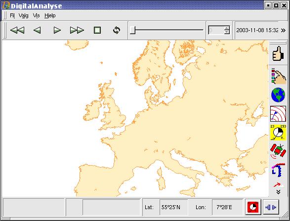


3 Visualisation model Taf monitoring Time series Time series editing 2D map Text editing Point verification

4 Diana Visualisation Fields Satellite and radar images Surface observations Soundings Cross Sections Trajectories in isosurfaces Forecast products
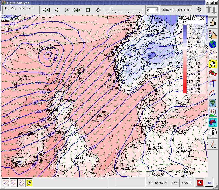
5 Fields
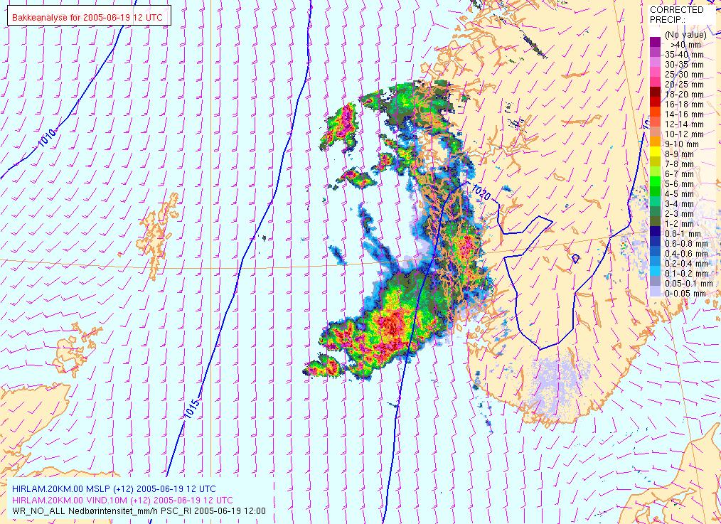
6 Images

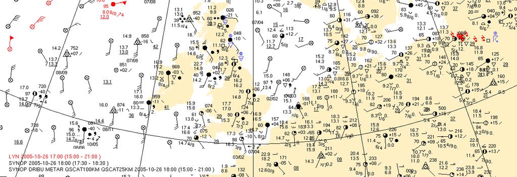
7 Observations

8 Diana with too much information

9 Diana some layers h
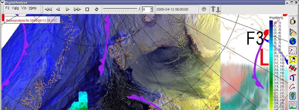
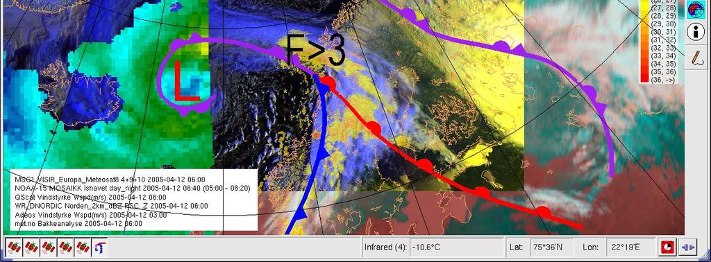
10 Diana

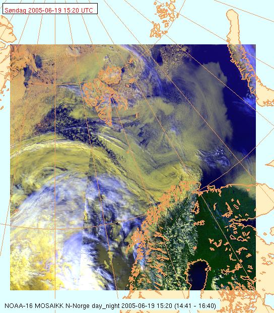
11 Diana: Image mosaic
")
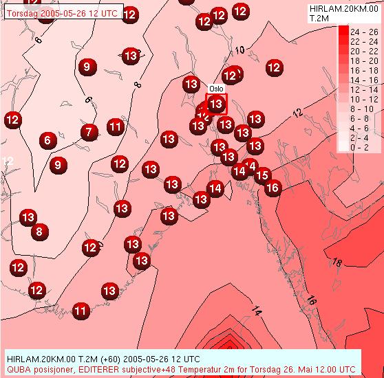
12 Criteria: Temp (red T>2, pink 2>T>-2, blue T< -2)

13 Criteria: Precipitation (Plot R>0, Red R>5mm)

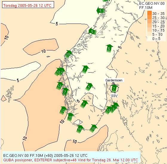
14 Criteria: Wind plot > 15 m/s red >22 m/s


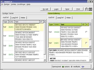
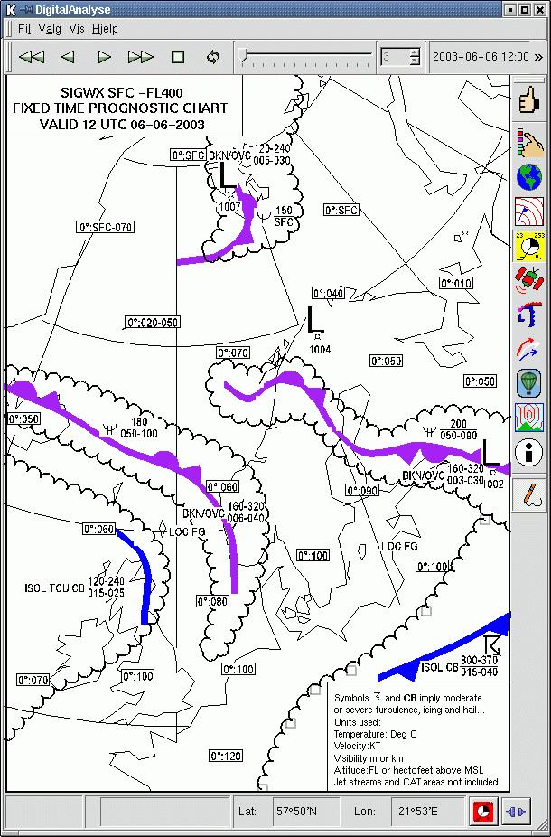
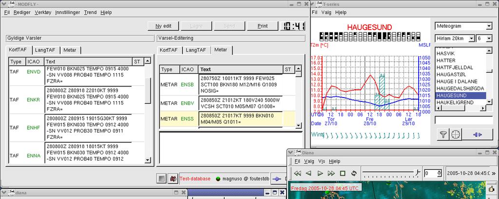
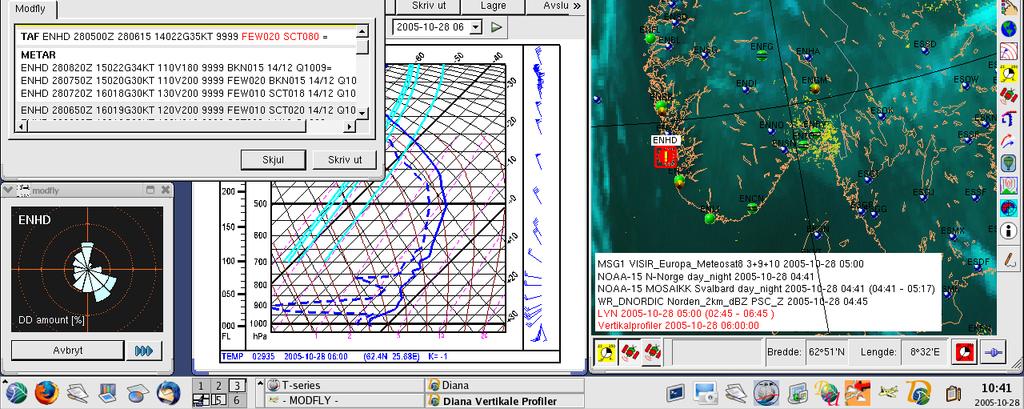
15 Vertical profiles and Crossection Preprocessed (yet)

16 DIANA Interactive tools Scalar field modification Drawing of fronts, weather symbols, etc. Combination of products from regional centers Data visualisation is fully available

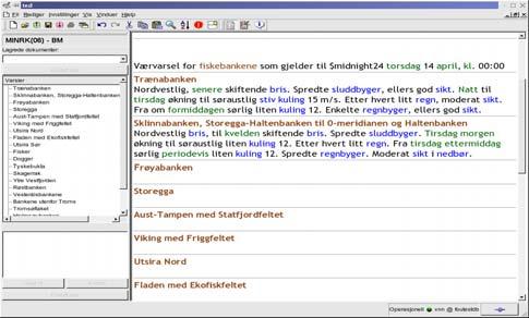
17 MSLP and Front Analysis
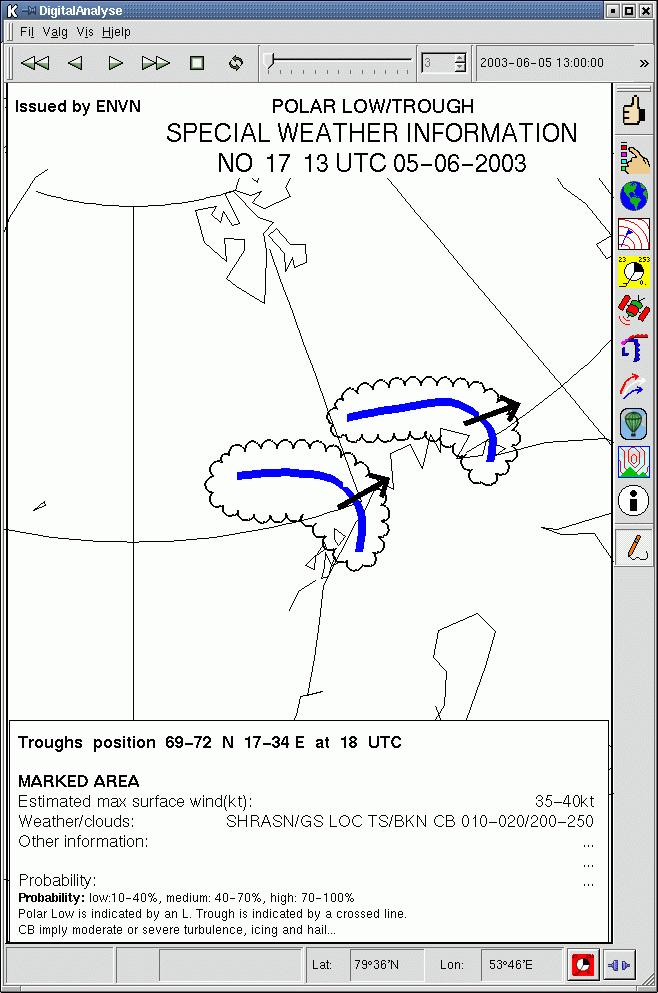
18 Significant weather Polar low
19 Visualisation model Taf monitoring Time series Time series editing 2D map Text editing Point verification

20 Meteogram tool


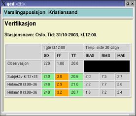
21 Forecast production Directly on map In separate table editor Climate and verification information available for each point
22 Point forecasting temperature and wind
23 TAF editor/monitor MODFLY - DIANA


24 Online verification of point forecasts Temperature bias Forecasted/observed weather


25 TEXT FORECAST Specialiced text editor for weather forecasts, recognizing areas and time period. Text for time/areas saved separately in database for reuse Translation, meteorologial dictionary Future: extracting forecast values for monitoring(against obs/models) and verification
26 DIANA Developed for operational use Increased usage by researchers Small development crew in close cooperation with forecasters Fast development cycle - monthly updates Easy to add new applications
27 DIANA - interfaces Tailored for operational use in a forecasting environment Dialogs and Quick menus (Standard and private) Most options/preferences and command history in a log to next session. Keyboard shortcuts for all functions Batch version identical code base
28 Programming environment Linux (Red Hat Fedora Core 3), all met.no workstations C++ (g++) Qt for GUI and window handling, platform independent Mesa3D OpenGL MySQL databases a few other freeware libraries (fonts etc.) connections between applications by Qt QSocket GPL: Freely available, free to use, free to change (from January 2006)
29 Open source release, January 2006 Taf monitoring Time series Time series editing 2D map Text editing Point verification
30 Free software release (GPL), January 2006 Multilingual dialogs (Qt Linguist translations) Make it easier to add other data formats Observation format: BUFR (with an ascii index) Field formats: NetCDF and GRIB (with some index) Image format: HDF5, geotiff
 Maps can be requested from different servers Clients can build customized")
31 Web Map Service A standard for showing maps in a web browser Defined by Open Geospatial Consortium (OGC) Maps can be requested from different servers Clients can build customized maps
32 Web Map Service Batch Diana make plots (png files) to be displayed by a Web Map Service on the fly Fast enough to let Diana make new plots when zooming or panning the map Interface between WMS and Diana: Now files, will be replaced by a socket connection Demand: Support many projections, PROJ4- library (which does not support wind/vector rotation )
33 Future at met.no Main project: PROFF = forecasts for the public One gridbased database with controlled and adjusted data. Resolution ~4 km. This database contains all data needed to make products (Maps, symbols, graphs, texts) Possibly sorted to get fast and easy access to point and area data. There will be databases with pure NWP to verify forecasters improvements and to point out the need for model improvements.
34 Adding value to high resolution data 1. Severe weather information 2. All forecast products should be consistent 3. High resolution forecasts 4. We accept dynamical inconsistencies
35 Future at met.no Currently, forecasters, researchers and ITdevelopers discuss how, and to what extent, the forecasters should modify the grid data. The further development of Diana highly depends on the result of these discussions.
István Ihász, Hungarian Meteorological Service, Budapest, Hungary
 Experiences using VarEPS products at the Hungarian Meteorological Service István Ihász, Hungarian Meteorological Service, Budapest, Hungary 1 Introduction ECMWF 15 day Variable Resolution Ensemble Prediction
Workstations at Met Éireann. Kieran Commins Head Applications Development
 Workstations at Met Éireann Kieran Commins Head Applications Development Background For many years Met Éireann has used several systems for visualisation of data X-charts for NWP Intranet for Satellite/radar
ECMWF Web re-engineering project
 ECMWF Web re-engineering project Baudouin Raoult Peter Bispham, Andy Brady, Jose Louis Casado, Ricardo Correa, Sylvie Lamy-Thepaut, Tim Orford, David Richardson, Cihan Sahin, Stephan Siemen, Carlos Valiente,
Application and verification of ECMWF products 2018
 Application and verification of ECMWF products 2018 National Meteorological Administration, Romania 1. Summary of major highlights In the field of numerical model verification, the daily GRID_STAT method
Climate Data for Non-experts: Standards-based Interoperability
 Climate Data for Non-experts: Standards-based Interoperability Ben Domenico Unidata Program Center University Corporation for Atmospheric Research April 2010 Working Together on A Mosaic for Atmospheric
Design and implementation of a new meteorology geographic information system
 Design and implementation of a new meteorology geographic information system WeiJiang Zheng, Bing. Luo, Zhengguang. Hu, Zhongliang. Lv National Meteorological Center, China Meteorological Administration,
eccharts Ensemble data and recent updates Cihan Sahin, Sylvie Lamy-Thepaut, Baudouin Raoult Web development team, ECMWF
 eccharts Ensemble data and recent updates Cihan Sahin, Sylvie Lamy-Thepaut, Baudouin Raoult Web development team, ECMWF cihan.sahin@ecmwf.int ECMWF June 8, 2015 Outline eccharts Ensemble data in eccharts
GIS at UCAR. The evolution of NCAR s GIS Initiative. Olga Wilhelmi ESIG-NCAR Unidata Workshop 24 June, 2003
 GIS at UCAR The evolution of NCAR s GIS Initiative Olga Wilhelmi ESIG-NCAR Unidata Workshop 24 June, 2003 Why GIS? z z z z More questions about various climatological, meteorological, hydrological and
Use of visualisation at ECMWF
 Use of visualisation at ECMWF Stephan Siemen Development Section, ECMWF Thanks to Jens Daabeck, Glenn Carver, Sylvie Lamy-Thepaut, Iain Russell, Fernando Ii, Sandor Kertesz Examples shown in this presentations
JOINT WMO TECHNICAL PROGRESS REPORT ON THE GLOBAL DATA PROCESSING AND FORECASTING SYSTEM AND NUMERICAL WEATHER PREDICTION RESEARCH ACTIVITIES FOR 2006
 JOINT WMO TECHNICAL PROGRESS REPORT ON THE GLOBAL DATA PROCESSING AND FORECASTING SYSTEM AND NUMERICAL WEATHER PREDICTION RESEARCH ACTIVITIES FOR 2006 [TURKEY/Turkish State Meteorological Service] 1. Summary
Data Format and Visualization Agenda
 Data Format and Visualization Agenda- 7.2.2 ET-SUP-8 (14.04.2014) Suman Goyal, Satellite Meteorology Division, India Meteorological Department, Suman_goyal61@yahoo.co.in Visualization Methods The satellite
What s new in GIS. RAL Retreat Oct 5, 2005
 What s new in GIS RAL Retreat Oct 5, 2005 Overview GIS Initiative milestones Major activities in 2004-2005 GALEON UNIDATA OGC project New functionality in ESRI software GIS Initiative Team Olga Wilhelmi
Introduction to geoprocessing services using SEXTANTE. Víctor Olaya SEXTANTE Geospatial Services
 Introduction to geoprocessing services using SEXTANTE. Víctor Olaya SEXTANTE Geospatial Services Overview Quick introduction to SEXTANTE Client/Server fundamentals Standards for web-based geoservices SEXTANTE
Finnish Open Data Portal for Meteorological Data
 18.11.2013 1 Finnish Open Data Portal for Meteorological Data 14th Workshop on meteorological operational systems Roope Tervo Finnish Meteorological Institute Example of Data Sets -- Observations Data
IMS4 AWOS. Automated Weather Observation System. Integrates all airport weather data
 Integrates all airport weather data IMS4 AWOS FEATURES: Integrates all airport weather data Scalable up to ICAO category CAT III Conforms to the ICAO and WMO regulations and recommendations AWOS data on
Northrop Grumman Concept Paper
 Northrop Grumman Concept Paper A Comprehensive Geospatial Web-based Solution for NWS Impact-based Decision Support Services Glenn Higgins April 10, 2014 Northrop Grumman Corporation Information Systems
What is CERA? Coastal Emergency Risks Assessment
 What is CERA? Coastal Emergency Risks Assessment Visualization tool using OGC standards Displays the outputs from the ADCIRC storm surge model or other coastal models Represents the maps on interactive
Application and verification of ECMWF products 2012
 Application and verification of ECMWF products 2012 National Meteorological Administration 1. Summary of major highlights The objective verification of all deterministic models forecasts in use have been
Among various open-source GIS programs, QGIS can be the best suitable option which can be used across partners for reasons outlined below.
 Comparison of Geographic Information Systems (GIS) software As of January 2018, WHO has reached an agreement with ESRI (an international supplier of GIS software) for an unlimited use of ArcGIS Desktop
Synergie PC Updates and Plans. A. Lasserre-Bigorry, B. Benech M-F Voidrot, & R. Giraud
 Synergie PC Updates and Plans A. Lasserre-Bigorry, B. Benech M-F Voidrot, & R. Giraud 1 2 3 4 Introduction Migration to PC-Linux Synergie 4.0 features Perspectives for 2006 ECMWF 10 th Workshop on Meteorological
Using the EartH2Observe data portal to analyse drought indicators. Lesson 4: Using Python Notebook to access and process data
 Using the EartH2Observe data portal to analyse drought indicators Lesson 4: Using Python Notebook to access and process data Preface In this fourth lesson you will again work with the Water Cycle Integrator
Recent Developments of the NinJo Workstation
 Recent Developments of the NinJo Workstation Gerhard Eymann, DWD, FEZE gerhard.eymann@dwd.de 13 th Workshop on Meteorological Operational Systems ECMWF Reading, UK Oct. 31 - Nov. 4, 2011 Selected Recent
JOINT WMO TECHNICAL PROGRESS REPORT ON THE GLOBAL DATA PROCESSING AND FORECASTING SYSTEM AND NUMERICAL WEATHER PREDICTION RESEARCH ACTIVITIES FOR 2007
 JOINT WMO TECHNICAL PROGRESS REPORT ON THE GLOBAL DATA PROCESSING AND FORECASTING SYSTEM AND NUMERICAL WEATHER PREDICTION RESEARCH ACTIVITIES FOR 2007 [TURKEY/Turkish State Meteorological Service] 1. Summary
Application and verification of ECMWF products in Norway 2008
 Application and verification of ECMWF products in Norway 2008 The Norwegian Meteorological Institute 1. Summary of major highlights The ECMWF products are widely used by forecasters to make forecasts for
Instituto de Pesquisas Meteorológicas - IPMet Universidade Estadual Paulista - Unesp
 IPMET WEB GIS APPLICATION FOR SEVERE WEATHER ALERT AND DECISION SUPPORT Jaqueline Murakami Kokitsu Instituto de Pesquisas Meteorológicas - IPMet Universidade Estadual Paulista - Unesp IPMet/Unesp Meteorological
Esri UC2013. Technical Workshop.
 Esri International User Conference San Diego, California Technical Workshops July 9, 2013 CAD: Introduction to using CAD Data in ArcGIS Jeff Reinhart & Phil Sanchez Agenda Overview of ArcGIS CAD Support
ADAGUC & PyTROLL. Maarten Plieger Ernst de Vreede. Application of polar orbiter products in weather forecasting Using open source tools and standards
 Application of polar orbiter products in weather forecasting Using open source tools and standards ADAGUC & PyTROLL Maarten Plieger Ernst de Vreede Royal Netherlands Meteorological Institute (KNMI) R&D
Exelis and Esri Technologies for Defense and National Security. Cherie Muleh
 Exelis and Esri Technologies for Defense and National Security Cherie Muleh Cherie.Muleh@exelisinc.com ENVI IMAGERY AND DATA BECOME KNOWLEDGE > Add information from imagery to your GIS > Automated workflows
Environmental Systems Research Institute
 Introduction to ArcGIS ESRI Environmental Systems Research Institute Redlands, California 2 ESRI GIS Development Arc/Info (coverage model) Versions 1-7 from 1980 1999 Arc Macro Language (AML) ArcView (shapefile
Watershed Application of WEPP and Geospatial Interfaces. Dennis C. Flanagan
 Watershed Application of WEPP and Geospatial Interfaces Dennis C. Flanagan Research Agricultural Engineer USDA-Agricultural Research Service Adjunct Professor Purdue Univ., Dept. of Agric. & Biol. Eng.
Presentation of met.no s experience and expertise related to high resolution reanalysis
 Presentation of met.no s experience and expertise related to high resolution reanalysis Oyvind Saetra, Ole Einar Tveito, Harald Schyberg and Lars Anders Breivik Norwegian Meteorological Institute Daily
Application of ALADIN/AROME at the Hungarian Meteorological Service
 ORSZÁGOS METEOROLÓGIAI SZOLGÁLAT Application of ALADIN/AROME at the Hungarian Meteorological Service Balázs Szintai Head, Unit of Methodology Development Host presentation at the ALADIN 20 th General Assembly
These modules are covered with a brief information and practical in ArcGIS Software and open source software also like QGIS, ILWIS.
 Online GIS Training and training modules covered are: 1. ArcGIS, Analysis, Fundamentals and Implementation 2. ArcGIS Web Data Sharing 3. ArcGIS for Desktop 4. ArcGIS for Server These modules are covered
State of GIS at the High Performance Computing Cluster
 State of GIS at the High Performance Computing Cluster Peter Löwe, Jan Thaler, Stefan Lüdtke² Centre for GeoInformation Technology (CeGIT) ² Section 5.4 (Hydrology) Computing Clusters A set of loosely
Quality of Information collected with the help of Map-Based Questionnaires
 Quality of Information collected with the help of Map-Based Questionnaires Contents 1. Introduction 2. Case Studie: The Switch Project in Wilhelmsburg 3. The Web Platform 1. Technical Architecture 2. Interactive
Introduction to ArcMap
 Introduction to ArcMap ArcMap ArcMap is a Map-centric GUI tool used to perform map-based tasks Mapping Create maps by working geographically and interactively Display and present Export or print Publish
Open Source ENKI: Dynamic Environmental Model Framework. A possible pre-processor for WRF-Hydro?
 Open Source ENKI: Dynamic Environmental Model Framework A possible pre-processor for WRF-Hydro? 1st European Fully Coupled AtmosphericHydrological Modeling and WRF-Hydro Users workshop. University of Calabria.
NinJo. Deutscher Wetterdienst. System Overview and Usage for Aviation Meteorology at DWD. Stephan Schmidt, Michael Rohn, Dirk Heizenreder
 NinJo System Overview and Usage for Aviation Meteorology at DWD Stephan Schmidt, Michael Rohn, Dirk Heizenreder 12th Workshop on Meteorological Operational Systems ECMWF, 2-6 November 2009 Outline 1. Overview,
Paper UC1351. Conference: User Conference Date: 08/10/2006 Time: 8:30am-9:45am Room: Room 23-B (SDCC)
") Conference: User Conference Date: 08/10/2006 Time: 8:30am-9:45am Room: Room 23-B (SDCC) Title of Paper: Increasing the Use of GIS in the Federal Government Author Name: Miss Abstract This presentation
Conference: User Conference Date: 08/10/2006 Time: 8:30am-9:45am Room: Room 23-B (SDCC) Title of Paper: Increasing the Use of GIS in the Federal Government Author Name: Miss Abstract This presentation
On the use of radar rainfall estimates and nowcasts in an operational heavy rainfall warning service
 On the use of radar rainfall estimates and nowcasts in an operational heavy rainfall warning service Alan Seed, Ross Bunn, Aurora Bell Bureau of Meteorology Australia The Centre for Australian Weather
BASIC TECHNOLOGY Pre K starts and shuts down computer, monitor, and printer E E D D P P P P P P P P P P
 BASIC TECHNOLOGY Pre K 1 2 3 4 5 6 7 8 9 10 11 12 starts and shuts down computer, monitor, and printer P P P P P P practices responsible use and care of technology devices P P P P P P opens and quits an
TRIVIS WEATHER GRAPHIX PRODUCT PACKAGES
 PRODUCT PACKAGES TRIVIS WEATHER GRAPHIX PRODUCT PACKAGES TriVis is the professional television weather graphics solution that delivers highest quality with legendary reliability daily on-air since over
A Distributed GIS Architecture for Research in Baalbek Based on CISAR
 234 Frank Henze A Distributed GIS Architecture for Research in Baalbek Based on CISAR Abstract: Research underway in Baalbek extends from the immediate vicinity of the excavation areas to the monumental
Geospatial Fire Behavior Modeling App to Manage Wildfire Risk Online. Kenyatta BaRaKa Jackson US Forest Service - Consultant
 Geospatial Fire Behavior Modeling App to Manage Wildfire Risk Online Kenyatta BaRaKa Jackson US Forest Service - Consultant Fire Behavior Modeling and Forest Fuel Management Modeling Fire Behavior is an
Hyper Borey User Guide
 METEO-GRAPHICS SYSTEMS IN C. Hyper Borey version 1.0 Meteo-Graphics Systems Inc. 5790 Rembrandt Avenue, suite 405. Montreal, Canada, H4B 2V2 T 514.262.5487 E info@meteograph.ca W www.meteograph.ca Table
Sense and Extensibility Towards Weather Objects Modelling Language (WOML)
") Sense and Extensibility Towards Weather Objects Modelling Language (WOML) Ilkka Rinne Finnish Meteorological Institute 2 nd workshop on the use of GIS/OGC standards in meteorology 23 rd November 2009 Modelling
Sense and Extensibility Towards Weather Objects Modelling Language (WOML) Ilkka Rinne Finnish Meteorological Institute 2 nd workshop on the use of GIS/OGC standards in meteorology 23 rd November 2009 Modelling
Geometric Algorithms in GIS
 Geometric Algorithms in GIS GIS Visualization Software Dr. M. Gavrilova GIS Software for Visualization ArcView GEO/SQL Digital Atmosphere AutoDesk Visual_Data GeoMedia GeoExpress CAVE? Visualization in
Experiments of clustering for central European area specially in extreme weather situations. István Ihász. Hungarian Meteorological Service
 Experiments of clustering for central European area specially in extreme weather situations István Ihász Hungarian Meteorological Service 1 1. ECMWF clustering 2. Clustering for central European area Forecasters
WEB MAP SERVICE (WMS) FOR GEOLOGICAL DATA GEORGE TUDOR
 FOR GEOLOGICAL DATA GEORGE TUDOR") WEB MAP SERVICE (WMS) FOR GEOLOGICAL DATA GEORGE TUDOR WEB MAP SERVICE (WMS) - GENERALITIES Projects with data from different sources Geological data are in different GIS software format Large amount of
WEB MAP SERVICE (WMS) FOR GEOLOGICAL DATA GEORGE TUDOR WEB MAP SERVICE (WMS) - GENERALITIES Projects with data from different sources Geological data are in different GIS software format Large amount of
What is 511? Need for 511 Services. Development & Deployment of Regional Road and Weather Information Supporting 511 Traveler Services
 Development & Deployment of Regional Road and Weather Information Supporting 511 Traveler Services Leon F. Osborne University of North Dakota Regional Weather Information Center Grand Forks, ND David L.
IMS4 ARWIS. Airport Runway Weather Information System. Real-time data, forecasts and early warnings
 Airport Runway Weather Information System Real-time data, forecasts and early warnings Airport Runway Weather Information System FEATURES: Detection and prediction of runway conditions Alarms on hazardous
gvsig a real tool for GIS technicians
 gvsig a real tool for GIS technicians Jorge Gaspar Sanz Salinas jsanz@prodevelop.es International Geodetic Students Meeting 05/05/08 Valencia Agenda of the project OK, but what can gvsig do for me now?
USAGE OF OLD MAPS AND THEIR DISTRIBUTION WITHIN THE FRAME OF WEB MAP SERVICES
 USAGE OF OLD MAPS AND THEIR DISTRIBUTION WITHIN THE FRAME OF WEB MAP SERVICES Jiri Cajthaml, Jiri Krejci Czech Technical University in Prague, Faculty of Civil Engineering, Department of Mapping and Cartography,
JOINT WMO TECHNICAL PROGRESS REPORT ON THE GLOBAL DATA PROCESSING AND FORECASTING SYSTEM AND NUMERICAL WEATHER PREDICTION RESEARCH ACTIVITIES FOR 2016
 JOINT WMO TECHNICAL PROGRESS REPORT ON THE GLOBAL DATA PROCESSING AND FORECASTING SYSTEM AND NUMERICAL WEATHER PREDICTION RESEARCH ACTIVITIES FOR 2016 New Zealand / Meteorological Service of New Zealand
Importance of Technology as part of the NWS New Orleans/Baton Rouge Impact- Based Decision Support Pilot Project
 Importance of Technology as part of the NWS New Orleans/Baton Rouge Impact- Based Decision Support Pilot Project NWS New Orleans Meteorologist-In-Charge: Ken Graham Emergency Response Specialist Team:
NOKIS - Information Infrastructure for the North and Baltic Sea
 NOKIS - Information Infrastructure for the North and Baltic Sea Carsten Heidmann 1 and Jörn Kohlus 2 Abstract 1. General The initial motivation for the project NOKIS (German title: Nord- und Ostsee-Küsteninformationssystem)
E x a m p l e s o f t o o l s f o r s e a s i t u a t i o n a l a w a r e n e s s u s i n g C M E M S d a t a. Copernicus EU
 E x a m p l e s o f t o o l s f o r s e a s i t u a t i o n a l a w a r e n e s s u s i n g C M E M S d a t a Copernicus EU Copernicus EU Copernicus EU www.copernicus.eu S e a S i t u a t i o n a l A w
Annual WWW Technical Progress Report. On the Global Data Processing and Forecasting System 2004 OMAN
 Annual WWW Technical Progress Report On the Global Data Processing and Forecasting System 2004 OMAN Summary of highlights Oman Meteorological Service, located in Muscat, Oman develops, produces and disseminates
The next generation in weather radar software.
 The next generation in weather radar software. PUBLISHED BY Vaisala Oyj Phone (int.): +358 9 8949 1 P.O. Box 26 Fax: +358 9 8949 2227 FI-00421 Helsinki Finland Try IRIS Focus at iris.vaisala.com. Vaisala
Appendix 4 Weather. Weather Providers
 Appendix 4 Weather Using weather data in your automation solution can have many benefits. Without weather data, your home automation happens regardless of environmental conditions. Some things you can
Developments towards multi-model based forecast product generation
 Developments towards multi-model based forecast product generation Ervin Zsótér Methodology and Forecasting Section Hungarian Meteorological Service Introduction to the currently operational forecast production
EXTRACTION AND VISUALIZATION OF WIND SPEED IN A GIS ENVIRONMENT FROM A WEATHER RESEARCH AND FORECASTING (WRF) OUTPUT USING PYTHON
 OUTPUT USING PYTHON") EXTRACTION AND VISUALIZATION OF WIND SPEED IN A GIS ENVIRONMENT FROM A WEATHER RESEARCH AND FORECASTING (WRF) OUTPUT USING PYTHON Jerome T. Tolentino 1, Ma. Victoria Rejuso 1, Jara Kaye Villanueva 1, Loureal
EXTRACTION AND VISUALIZATION OF WIND SPEED IN A GIS ENVIRONMENT FROM A WEATHER RESEARCH AND FORECASTING (WRF) OUTPUT USING PYTHON Jerome T. Tolentino 1, Ma. Victoria Rejuso 1, Jara Kaye Villanueva 1, Loureal
This tutorial is intended to familiarize you with the Geomatica Toolbar and describe the basics of viewing data using Geomatica Focus.
 PCI GEOMATICS GEOMATICA QUICKSTART 1. Introduction This tutorial is intended to familiarize you with the Geomatica Toolbar and describe the basics of viewing data using Geomatica Focus. All data used in
GENERALIZATION IN THE NEW GENERATION OF GIS. Dan Lee ESRI, Inc. 380 New York Street Redlands, CA USA Fax:
 GENERALIZATION IN THE NEW GENERATION OF GIS Dan Lee ESRI, Inc. 380 New York Street Redlands, CA 92373 USA dlee@esri.com Fax: 909-793-5953 Abstract In the research and development of automated map generalization,
The PREVIEW Global Risk Data Platform: a geoportal to serve and share global data on risk to natural hazards
 The PREVIEW Global Risk Data Platform: a geoportal to serve and share global data on risk to natural hazards Gregory Giuliani (UNEP/GRID-Geneva & University of Geneva/enviroSPACE ) http://www.grid.unep.ch
Introduction to ArcGIS Server - Creating and Using GIS Services. Mark Ho Instructor Washington, DC
 Introduction to ArcGIS Server - Creating and Using GIS Services Mark Ho Instructor Washington, DC Technical Workshop Road Map Product overview Building server applications GIS services Developer Help resources
WRF Modeling System Overview
 WRF Modeling System Overview Jimy Dudhia What is WRF? WRF: Weather Research and Forecasting Model Used for both research and operational forecasting It is a supported community model, i.e. a free and shared
Application and verification of ECMWF products 2008
 Application and verification of ECMWF products 2008 RHMS of Serbia 1. Summary of major highlights ECMWF products are operationally used in Hydrometeorological Service of Serbia from the beginning of 2003.
Analyzing Multidimensional Scientific Data in ArcGIS. Nawajish Noman Deng Ding
 Analyzing Multidimensional Scientific Data in ArcGIS Nawajish Noman Deng Ding Outline Part I - ArcGIS Platform - Scientific Multidimensional Data - Ingest and Data Management Part II - Data Exploration
The NOAA/NESDIS/STAR IASI Near Real-Time Product Processing and Distribution System
 The NOAA/NESDIS/STAR Near Real-Time Product Processing and Distribution System W. Wolf 2, T. King 1, Z. Cheng 1, W. Zhou 1, H. Sun 1, P. Keehn 1, L. Zhou 1, C. Barnet 2, and M. Goldberg 2 1 QSS Group Inc,
Deutscher Wetterdienst
 Deutscher Wetterdienst NUMEX Numerical Experiments and NWP-development at DWD 14th Workshop on Meteorological Operational Systems ECMWF 18-20 November 2013 Thomas Hanisch GB Forschung und Entwicklung (FE)
Incorporating ArcGIS Pro in your Curriculum
 AAG, Boston 2017 April 5, 2017 Incorporating ArcGIS Pro in your Curriculum Geri Miller Agenda Concerns Acknowledged Learning curve ArcGIS Pro does not have all the tools (perception) Licensing and offline
RHOAPS. Real-time Hydrology Ocean Atmosphere Prediction System. Pronunciation: Ropes Motto: More than just THREDDS
 RHOAPS Real-time Hydrology Ocean Atmosphere Prediction System Pronunciation: Ropes Motto: More than just THREDDS Key Aspects Integrated real-time data systems Atmospheric Hydrologic Coastal oceans Societal
MSGVIEW: AN OPERATIONAL AND TRAINING TOOL TO PROCESS, ANALYZE AND VISUALIZATION OF MSG SEVIRI DATA
 MSGVIEW: AN OPERATIONAL AND TRAINING TOOL TO PROCESS, ANALYZE AND VISUALIZATION OF MSG SEVIRI DATA Aydın Gürol Ertürk Turkish State Meteorological Service, Remote Sensing Division, CC 401, Kalaba Ankara,
CAPACITY BUILDING FOR NON-NUCLEAR ATMOSPHERIC TRANSPORT EMERGENCY RESPONSE ACTIVITIES. (Submitted by RSMC-Beijing) Summary and purpose of document
 Summary and purpose of document") WORLD METEOROLOGICAL ORGANIZATION COMMISSION FOR BASIC SYSTEMS OPAG on DPFS Task Team on Development of Operational Procedures for non-nuclear ERA CBS-DPFS/TT-DOP-nNERA/Doc.8 (4.X.2012) Agenda item : 8
WORLD METEOROLOGICAL ORGANIZATION COMMISSION FOR BASIC SYSTEMS OPAG on DPFS Task Team on Development of Operational Procedures for non-nuclear ERA CBS-DPFS/TT-DOP-nNERA/Doc.8 (4.X.2012) Agenda item : 8
National Climatic Data Center Data Management Issues Tom Karl Director, NOAA s National Climatic Data Center
 National Climatic Data Center Data Management Issues Tom Karl Director, NOAA s National Climatic Data Center Opening Meeting NOAA Science Advisory Board s Data Archiving and Access Requirements Working
Introduction to ArcGIS Server Development
 Introduction to ArcGIS Server Development Kevin Deege,, Rob Burke, Kelly Hutchins, and Sathya Prasad ESRI Developer Summit 2008 1 Schedule Introduction to ArcGIS Server Rob and Kevin Questions Break 2:15
Karsten Vennemann, Seattle. QGIS Workshop CUGOS Spring Fling 2015
 Karsten Vennemann, Seattle 2015 a very capable and flexible Desktop GIS QGIS QGIS Karsten Workshop Vennemann, Seattle slide 2 of 13 QGIS - Desktop GIS originally a GIS viewing environment QGIS for the
Celestia Development Status
 Celestia Development Status Chris Laurel claurel@gmail.com 3 rd ESA Workshop on Astrodynamics Tools and Techniques 2-5 October 2006 ESTEC, Noordwijk, The Netherlands Contents Introducing Celestia Development
WEATHER AND CLIMATE COMPLETING THE WEATHER OBSERVATION PROJECT CAMERON DOUGLAS CRAIG
 WEATHER AND CLIMATE COMPLETING THE WEATHER OBSERVATION PROJECT CAMERON DOUGLAS CRAIG Introduction The Weather Observation Project is an important component of this course that gets you to look at real
4D information management system for road maintenance using GIS
 icccbe 2010 Nottingham University Press Proceedings of the International Conference on Computing in Civil and Building Engineering W Tizani (Editor) 4D information management system for road maintenance
Amita Mehta and Ana Prados
 Building Capacity in Utilizing NASA Remote Sensing Observations in SWAT for Water Resources and Agricultural Management Applications Amita Mehta and Ana Prados NASA - University of Maryland Baltimore County
Lecture 2. Introduction to ESRI s ArcGIS Desktop and ArcMap
 Lecture 2 Introduction to ESRI s ArcGIS Desktop and ArcMap Outline ESRI What is ArcGIS? ArcGIS Desktop ArcMap Overview Views Layers Attribute Tables Help! Scale Tips and Tricks ESRI Environmental Systems
Cloud-based WRF Downscaling Simulations at Scale using Community Reanalysis and Climate Datasets
 Cloud-based WRF Downscaling Simulations at Scale using Community Reanalysis and Climate Datasets Luke Madaus -- 26 June 2018 luke.madaus@jupiterintel.com 2018 Unidata Users Workshop Outline What is Jupiter?
WMS 10.1 Tutorial GSSHA Applications Precipitation Methods in GSSHA Learn how to use different precipitation sources in GSSHA models
 v. 10.1 WMS 10.1 Tutorial GSSHA Applications Precipitation Methods in GSSHA Learn how to use different precipitation sources in GSSHA models Objectives Learn how to use several precipitation sources and
STATISTICAL MODELS and VERIFICATION
 STATISTICAL MODELS and VERIFICATION Mihaela NEACSU & Otilia DIACONU ANM/LMN/AMASC COSMO-September 2013 Mihaela NEACSU & Otilia DIACONU (ANM/LMN/AMASC) MOS & VERIF COSMO-September 2013 1 / 48 SUMMARY 1
Methodological Chain for Hydrological Management with Web-GIS Applications
 Advances in Geosciences Konstantinos Perakis & Athanasios Moysiadis, Editors EARSeL, 2012 Methodological Chain for Hydrological Management with Web-GIS Applications Alexandros Konstantinidis 1, Eleni Tzanou
Improvement of ASECNA nowcasting and MET services through SAAPI solution
 Loïc Le Gallou, MFI Thomas Sobakam, ASECNA Saly, Senegal, November 28 th, 2018 Improvement of ASECNA nowcasting and MET services through SAAPI solution SUMMARY 1. About SAAPI Project : needs and solution
Application and verification of ECMWF products at the Finnish Meteorological Institute
 Application and verification of ECMWF products 2010 2011 at the Finnish Meteorological Institute by Juhana Hyrkkènen, Ari-Juhani Punkka, Henri Nyman and Janne Kauhanen 1. Summary of major highlights ECMWF
Web-GIS based Framework for Solid Waste Complaint Management for Sustainable and Smart City
 Cloud Publications International Journal of Advanced Remote Sensing and GIS 2016, Volume 5, Issue 10, pp. 1930-1936 ISSN 2320-0243, DOI: 10.23953/cloud.ijarsg.71 Research Article Open Access Web-GIS based
Exploiting ensemble members: forecaster-driven EPS applications at the met office
 Exploiting ensemble members: forecaster-driven EPS applications at the met office Introduction Ensemble Prediction Systems (EPSs) have assumed a central role in the forecast process in recent years. The
McIDAS-V Tutorial Displaying Point Observations from ADDE Datasets updated July 2016 (software version 1.6)
") McIDAS-V Tutorial Displaying Point Observations from ADDE Datasets updated July 2016 (software version 1.6) McIDAS-V is a free, open source, visualization and data analysis software package that is the
McIDAS-V Tutorial Displaying Point Observations from ADDE Datasets updated July 2016 (software version 1.6) McIDAS-V is a free, open source, visualization and data analysis software package that is the
AMPS Update June 2016
 AMPS Update June 2016 Kevin W. Manning Jordan G. Powers Mesoscale and Microscale Meteorology Laboratory National Center for Atmospheric Research Boulder, CO 11 th Antarctic Meteorological Observation,
OSGIS Platform. Storing and distributing PostGIS, Deegree, UMN Map Server Desktop visualization JUMP, QGIS, Thuban, udig, gvsig
 GIS groups of tasks Geodata collecting, updating Geodata storing and distributing Geodata analysis Geodata visualization: Desktop, Internet, Printing Geodata describing: metadata management Geodata converting:
Hindcast Arabian Gulf
 Hindcast Arabian Gulf Image of isobars of atmospheric pressure and hindcast wind- and wave field over the Arabian Gulf during a storm in January 1993. Detailed wave studies are supported by nesting of
Strategic Radar Enhancement Project (SREP) Forecast Demonstration Project (FDP) The future is here and now
 Forecast Demonstration Project (FDP) The future is here and now") Strategic Radar Enhancement Project (SREP) Forecast Demonstration Project (FDP) The future is here and now Michael Berechree National Manager Aviation Weather Services Australian Bureau of Meteorology
Strategic Radar Enhancement Project (SREP) Forecast Demonstration Project (FDP) The future is here and now Michael Berechree National Manager Aviation Weather Services Australian Bureau of Meteorology
ArcGIS for the Military: Analyzing the Operational Environment
 Federal GIS Conference 2014 February 10 11, 2014 Washington DC ArcGIS for the Military: Analyzing the Operational Environment Matt Funk Esri (Redlands) ArcGIS for the Military Operations Planning Mounted
Managing Imagery and Raster Data Using Mosaic Datasets
 Esri International User Conference San Diego, California Technical Workshops July 25, 2012 Managing Imagery and Raster Data Using Mosaic Datasets Hong Xu, Prashant Mangtani Presentation Overview Introduction
Lessons learnt from EPS Cal/Val. F. Montagner & H. Bonekamp EUMETSAT
 Lessons learnt from EPS Cal/Val F. Montagner & H. Bonekamp EUMETSAT Introduction EUMETSAT Scientific Products Validation Team Commissioning of EPS system including Cal/val of Metop-A satellite products
Integrated Electricity Demand and Price Forecasting
 Integrated Electricity Demand and Price Forecasting Create and Evaluate Forecasting Models The many interrelated factors which influence demand for electricity cannot be directly modeled by closed-form