Weather Resources for Forensics
|
|
|
- Joel Gibson
- 6 years ago
- Views:
Transcription
1 Weather Resources for Forensics 23 Feb 2009 Ken Scheeringa Associate State Climatologist web: 1
2 Overview US Climate Services Structure The Indiana State Climate Office Weather records in forensic meteorology NWS cooperative weather stations CoCoRaHS Automated Surface Observation Stations (ASOS) Storm event data Astronomical tables Go to see the WSSRD (of NOAA not Oz) Useful weather data web sites 2
3 US Climate Services Structure a 3-tier hierarchy national tier National Climatic Data Center located in Asheville NC regional tier Regional Climate Data Center (six) state tier State Climate Offices (most states)

4 US Climate Services regional tier Regional Climate Centers

5 US Climate Services state tier one per state State Climate Office purpose is to document and study the climate of the state the state archive of official daily and hourly weather observations recorded throughout the state provides unique local climate observations and summaries understands very localized climate features interprets and applies this data to solve client climate related problems


6 Current/Ongoing Office Activities Archive and QC data Timely response to information requests Weekly and Monthly Climate Summary Frost Climatology Indiana Climate Atlas Evapotranspiration Study CoCoRaHS Soil Moisture Climatology 6

7 Most requests for climate information come from Agriculture Research and Education Environmental Agencies Government Agencies Attorneys Construction Forensics Insurance Adjustors Utilities Companies News Media Interested Citizens 7
8 What is forensic meteorology process of reconstructing weather events for a certain location using evidence such as eyewitness accounts local weather reports radar and satellite images expert analysis and interpretation of weather conditions often used in civil and criminal trials (eg, homocide) insurance claims verify compliance with environmental regulations 8
9 problems with eyewitness accounts eyewitness is under stress different versions of the same event different physical viewpoint of the incident too many details to capture in a split second focus may be limited to a threatening item memory of an event can begin to fade immediately attempts to fill in the gaps where lapses occur inaccuracies biases assumptions agendas 9
10 Why weather records are helpful usually a permanent archived written record (human) weather observer is not an eyewitness unaware of the concurrent incident unbiased weather observer can be a machine (data logger) able to capture many weather parameters accurate, and very fast multiple focal points (simultaneous recording) can be accurately reviewed / replayed at a later time no assumptions or agendas 10
11 Where can weather records be found short term archival available on many web sites updated hourly, daily, and monthly caveat: preliminary data, not fully quality controlled long term archival available at only a few web sites both preliminary and final edited data, quality controlled final data can lag a few months after observation time available at public and government climatology centers electronic and hard copy 11
12 How are weather records classified Classes of weather records are based on time scale daily hourly by minute and primary application monitoring the climate pilot information public warning All classes are useful in research These classes are defined into observation networks 12
13 Weather observation networks Examples of weather observation networks Cooperative station Volunteers for long term committment Monitor long term climate changes Provides data for short term needs CoCoRaHS Grass-roots, backyard, volunteers of all ages Monitors precipitation for many uses ASOS Automated sensors and data loggers Weather monitoring for pilots Research of past weather events 13


14 NWS cooperative stations a resource for daily weather observations 14
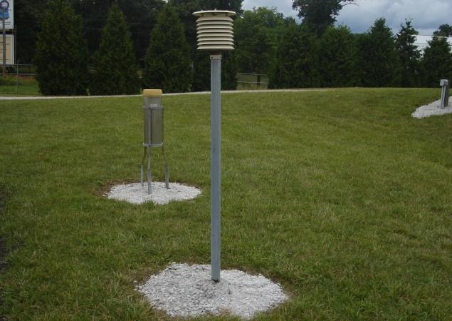
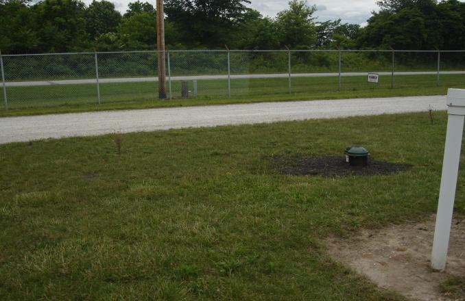
15 NWS Cooperative station example 15
16 NWS Cooperative station elements Weather elements observed Primarily temperature, rainfall, snowfall a handful of stations measure soil temperature, relative humidity, evaporation, solar radiation, wind Offline hard copy resource Data are published monthly in Climatological Data (Indiana) 16
17 Climatological Data - Indiana (cover) certification statement is on this page
18 Climatological Data Indiana (station index) Go first to the end of the publication to pages titled Station Index. an inventory of active cooperative substations in Indiana at the time of publication and gives valuable information station name, index number and climate division station location county, latitude, longitude, elevation weather elements observed and time of observation observer s name 18
19 Climatological Data Indiana (station index)
20 Climatological Data Indiana (temperature)
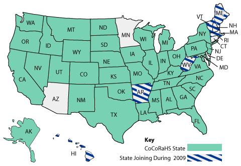
21 Climatological Data Indiana (precipitation)
22 Climatological Data Tips Be careful with time of observation!! This can trip up an investigation. Each daily observation is for the 24 hour period ENDING at the time of observation. Example: Station Index says time of observation is 8 am for this station then data listed for July 20 are for the 24 hour period 8 am on July 19 8 am on July 20 22
23 What are official weather data Cooperative stations are designated as official data operated by volunteers supervised by the National Weather Service uses NWS approved equipment often equipment is supplied by NWS at least once annual on site visits by NWS data are quality controlled by federal agencies endorsed by climatologists worldwide are more readily accepted in court 23
24 Cooperative station data online Portal web sites for cooperative station data Locate a cooperative station Recent cooperative station data Historical cooperative station data Let s try these now (live demo) 24
25 CoCoRaHS a resource for daily precipitation data 25

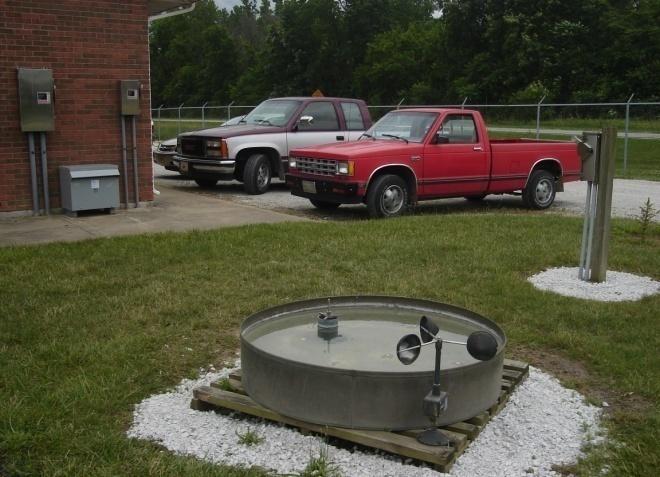
26 What is CoCoRaHS CoCoRaHS is a grassroots volunteer network of backyard weather observers of all ages and backgrounds working together to measure and map precipitation (rain, hail and snow) in their local communities. By using low-cost measurement tools, stressing training and education, and utilizing an interactive Website, our aim is to provide the highest quality data for natural resource, education and research applications. The only requirements to join are an enthusiasm for watching and reporting weather conditions and a desire to learn more about how weather can effect and impact our lives. 26
27 Why CoCoRaHS Cooperative station network precipitation data should be supplemented because Precipitation is highly variable over short distances Stations are few and far between typically only one or two stations per county CoCoRaHS objectives Preferred station density would be 20 times Consistency insures high data quality standard equipment standard measurement technique standard reporting site and procedure 27


28 Where is CoCoRaHS Indiana has 1033 Observers!
 www.cocorahs.")
29 Observers enter data to the CoCoRaHS web site Water Content of Melted Snow and ice That Fell in the Last 24 Hours Depth of new snow and ice in the last 24 hrs. Total Depth of Snow on the ground (new + old)

30 Other Reports Hail Report Intense Precipitation Report Monthly Zeros Multi-Day Precipitation Report Daily Precipitation Report Photo by Henry Reges
31 CoCoRaHS station data online The portal web site for CoCoRaHS This web site is used by observers to enter data and by the public to retrieve CoCoRaHS data Let s visit this web site now (live demo) 31
32 CoCoRaHS - Tips There is no offline data publication CoCoRaHS data is not official No NWS annual visits to verify proper station setup and observation procedure but observers are trained to assure a high quality dataset 32


33 Automated Surface Observing Stations (ASOS) a resource for hourly weather data

34 ASOS stations in Indiana
35 ASOS station elements Weather elements observed Sky conditions - cloud height and cloud amount up to 12,000 feet Surface visibility up to at least 10 statute miles Basic present weather information such as the type and intensity for rain, snow, and freezing rain Obstructions to vision like fog, haze, and/or dust Sea-level pressure and altimeter settings Air and dew point temperatures Wind direction, speed and character (gusts, squalls) Precipitation accumulation Selected significant remarks including- variable cloud height, variable visibility, precipitation beginning/ending times, rapid pressure changes, pressure change tendency, wind shift, peak wind. 35
36 ASOS data publication Offline hard copy resource Data are published monthly in Local Climatological Data (station name)

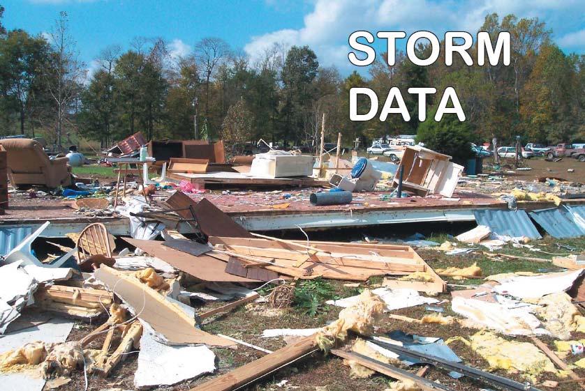
37 Local Climatological Data IND (p 1)
38 Local Climatological Data IND (p 2)

39 Local Climatological Data IND (p 6)
40 Local Climatological Data IND (p 8) a certification statement is on this page
41 Local Climatological Data Tips Note that the Observations page displays data for every third hour to conserve page space. Data for every hour are available online. Hourly precipitation data are recorded using a tipping bucket rain gauge which is unreliable in winter. It is best to find a nearby cooperative station for comparison when using wintertime precipitation. 41
42 ASOS are official data Local Climatological Data from ASOS sites are designated as official data data collection by automated equipment operated by the National Weather Service uses NWS installed equipment NWS technicians are assigned routine ASOS maintenance data are quality controlled by NWS in near real time further quality control is by National Climatic Data Center endorsed by climatologists worldwide are more readily accepted in court 42
43 ASOS station data online Portal web sites for ASOS station data Locate an ASOS station Recent ASOS station data (previous 3 days) Historical ASOS station data (since 1940s) (previous month) Let s try these now (live demo) 43
44
45 Storm Data what is it Storm data is the official federal collection of severe and unusual weather events This collection is entered into an online database and is printed monthly as a NOAA publication titled Storm Data and Unusual Weather Phenonema
46 Who collects Storm Data Each of the NWS s Weather Forecast Offices is responsible for collecting data from storm events. They collect these reports from: Official NWS storm surveys Emergency managers Official NWS observations CoCoRaHS reports Amateur radio operators Newspaper clippings / Media outlets Other sources Weather Forecast Offices have up to 60 days from the end of a month to transmit storm data to NWS headquarters
47 What facts are included in Storm Data Event Type (ex. tornado, winter storm, flood) Beginning and Ending time of event Beginning and Ending location (state, county, location) Source of the report Event magnitude (tornado ef-scale, hail size, wind gust) Injuries and deaths associated with the event Crop and property damage estimates Narrative description of the event
48 What is Storm Data used for Storm Data publication Storm Prediction Center s official severe weather database NWS short fuse warning verification statistics NWS internal service assessments Army Corp of Engineers (structure design) academic research studies disaster reports Congressional and other government data requests public data requests

49 Storm Data and Unusual Weather Phenomena published by National Climatic Data Center chronological listing by state events documented hurricanes tornadoes thunderstorms hail floods drought lightning high winds snow temperature extremes other weather phenomena statistics on personal injuries and damage estimates

50 Storm Data (Outstanding Storms)
51 Storm Data (storm event listing)
52 Storm Data - Tips Small storm events are often not listed impact was in a small area (eg, local hail event) no information from the public (rural area) Because a storm is not listed in Storm Data does not necessarily mean it didn t occur. This is a critical fact for insurance adjusters to know. Try to find related data sources that mention thunderstorms, or use radar data. By its very nature, Storm Data publication lags the event by six or more months. So what if we can t wait that long?
53 Storm event online databases Recent Storm events (since 2 Jan 2000) NWS Local Storm Reports hosted by the Storm Prediction Center best if you already know the approximate date Historical storm events ( most data since 1950s) NCDC Storm Events hosted by National Climatic Data Center Let s try these now (live demo)

54 Recent storm events - online

55 Historical Storm Events - online
56 Astronomical Tables The most commonly used in the forensics field are Sunrise and Sunset tables Moonrise and Moonset Cases usually involve crime scenes where visible identity of suspects is dependant on natural light levels (sun or moon) The best portal for astronomical tables is Let s try this web site now (live demo)

57 Sunrise and Sunset tables (request)

58 Sunrise / Sunset for 2009 at Kokomo
59 Where to find weather data publications Paper or microform copy most libraries designated as federal depository libraries should carry past issues of Climatological Data and Local Climatological Data. Both have been published for many years. Online web access Go to see the WSSRD (of NOAA not Oz)! WSSRD is an exhaustive online archive of most all federal weather data documents ever printed (since 1800s). You will need a username and password to access WSSRD, but this is easy to get and access is free. Ask Ken for contact information if you would like to get access to WSSRD. This is a federal website run by an independent contractor for now. Let s try this web site now (live demo)

60 WSSRD printed federal weather documents
61 Other useful weather web sites (1) Current weather Citizen Weather Observer Program Current local weather conditions Current local weather warnings Lightning data
62 Other useful weather web sites (2) Archived weather data Daily weather map archive National Lightning Detection Network (by subscription) Monthly weather summaries (Indiana since 2005) National radar image archive (since 1995) National daily observed precipitation maps
63 Other useful weather web sites (3) Climatology and weather education The ultimate weather education website Precipitation Frequency data server web site to determine intense rainfall return periods for many towns in Indiana and the nation


64 Dr. Dev Niyogi Ken Scheeringa State Climatologist Associate State Climatologist Thank you! 64
NJ Community Collaborative Rain, Hail and Snow Network
 NJ Community Collaborative Rain, Hail and Snow Network Mathieu Gerbush NJ Assistant State Climatologist/Climate Services Co-CoCoRaHS Coordinator NJ Agricultural Experiment Station School of Environmental
National Weather Service Greenville-Spartanburg, Forecast Office
 National Weather Service Greenville-Spartanburg, Forecast Office CoCoRaHS Presentation: NC CERT Conference May, 2017 Introduction- who we are. Federal Agency Within the U.S. Dept. of Commerce Introduction-
The Kentucky Mesonet: Entering a New Phase
 The Kentucky Mesonet: Entering a New Phase Stuart A. Foster State Climatologist Kentucky Climate Center Western Kentucky University KCJEA Winter Conference Lexington, Kentucky February 9, 2017 Kentucky
National Weather Service Flood Forecast Needs: Improved Rainfall Estimates
 National Weather Service Flood Forecast Needs: Improved Rainfall Estimates Weather Forecast Offices Cleveland and Northern Indiana Ohio River Forecast Center Presenter: Sarah Jamison, Service Hydrologist
CoCoRaHS Monitoring Colorado s s Water Resources through Community Collaborations
 CoCoRaHS Monitoring Colorado s s Water Resources through Community Collaborations Nolan Doesken Colorado Climate Center Atmospheric Science Department Colorado State University Presented at Sustaining
The Climate of Kiowa County
 The Climate of Kiowa County Kiowa County is part of the Central Great Plains, encompassing some of the best agricultural land in Oklahoma. Average annual precipitation ranges from about 24 inches in northwestern
The Climate of Pontotoc County
 The Climate of Pontotoc County Pontotoc County is part of the Crosstimbers. This region is a transition region from the Central Great Plains to the more irregular terrain of southeast Oklahoma. Average
The Climate of Marshall County
 The Climate of Marshall County Marshall County is part of the Crosstimbers. This region is a transition region from the Central Great Plains to the more irregular terrain of southeastern Oklahoma. Average
The Climate of Bryan County
 The Climate of Bryan County Bryan County is part of the Crosstimbers throughout most of the county. The extreme eastern portions of Bryan County are part of the Cypress Swamp and Forest. Average annual
United States Multi-Hazard Early Warning System
 United States Multi-Hazard Early Warning System Saving Lives Through Partnership Lynn Maximuk National Weather Service Director, Central Region Kansas City, Missouri America s s Weather Enterprise: Protecting
Weather versus Climate: What is the difference? Sources of Weather Information
 Joel O. Paz, Extension Agrometerologist and Gerrit Hoogenboom, Professor & REI Coordinator Department of Biological and Agricultural Engineering Weather versus Climate: What is the difference? The difference
The Climate of Payne County
 The Climate of Payne County Payne County is part of the Central Great Plains in the west, encompassing some of the best agricultural land in Oklahoma. Payne County is also part of the Crosstimbers in the
Applications/Users for Improved S2S Forecasts
 Applications/Users for Improved S2S Forecasts Nolan Doesken Colorado Climate Center Colorado State University WSWC Precipitation Forecasting Workshop June 7-9, 2016 San Diego, CA First -- A short background
Citizen Science Networks
 LIVE INTERACTIVE LEARNING @ YOUR DESKTOP Citizen Science Networks Presented by: Henry Reges and James Zdrojewski October 12, 2011 CoCoRaHS Because every drop counts What is CoCoRaHS? An overview CoCoRaHS
CoCoRaHS. Community Collaborative Rain, Hail, & Snow Network. Ashley Wolf Meteorologist NWS Green Bay Northeast Wisconsin CoCoRaHS Coordinator
 CoCoRaHS Community Collaborative Rain, Hail, & Snow Network Ashley Wolf Meteorologist NWS Green Bay Northeast Wisconsin CoCoRaHS Coordinator What is CoCoRaHS Who, What, Where and Whys of CoCoRaHS What?
The Climate of Grady County
 The Climate of Grady County Grady County is part of the Central Great Plains, encompassing some of the best agricultural land in Oklahoma. Average annual precipitation ranges from about 33 inches in northern
SAMPLE. SITE SPECIFIC WEATHER ANALYSIS Rainfall Report. Bevins Engineering, Inc. Susan M. Benedict. July 1, 2017 REFERENCE:
 SAMPLE SITE SPECIFIC WEATHER ANALYSIS Rainfall Report PREPARED FOR: Bevins Engineering, Inc. Susan M. Benedict July 1, 2017 REFERENCE: DUBOWSKI RESIDENCE / FILE# 11511033 1500 Water Street, Pensacola,
National Climatic Data Center DATA DOCUMENTATION FOR DATA SET 6406 (DSI-6406) ASOS SURFACE 1-MINUTE, PAGE 2 DATA. July 12, 2006
 ASOS SURFACE 1-MINUTE, PAGE 2 DATA. July 12, 2006") DATA DOCUMENTATION FOR DATA SET 6406 (DSI-6406) ASOS SURFACE 1-MINUTE, PAGE 2 DATA July 12, 2006 151 Patton Ave. Asheville, NC 28801-5001 USA Table of Contents Topic Page Number 1. Abstract... 3 2. Element
DATA DOCUMENTATION FOR DATA SET 6406 (DSI-6406) ASOS SURFACE 1-MINUTE, PAGE 2 DATA July 12, 2006 151 Patton Ave. Asheville, NC 28801-5001 USA Table of Contents Topic Page Number 1. Abstract... 3 2. Element
The Climate of Seminole County
 The Climate of Seminole County Seminole County is part of the Crosstimbers. This region is a transition region from the Central Great Plains to the more irregular terrain of southeastern Oklahoma. Average
The Climate of Murray County
 The Climate of Murray County Murray County is part of the Crosstimbers. This region is a transition between prairies and the mountains of southeastern Oklahoma. Average annual precipitation ranges from
The Climate of Texas County
 The Climate of Texas County Texas County is part of the Western High Plains in the north and west and the Southwestern Tablelands in the east. The Western High Plains are characterized by abundant cropland
Eastern Shore Weather and Climate. Bill Sammler Warning Coordination Meteorologist National Weather Service Wakefield, VA
 Eastern Shore Weather and Climate Bill Sammler Warning Coordination Meteorologist National Weather Service Wakefield, VA About The NWS The National Weather Service is: A Federal Government Agency Part
The Climate of Haskell County
 The Climate of Haskell County Haskell County is part of the Hardwood Forest. The Hardwood Forest is characterized by its irregular landscape and the largest lake in Oklahoma, Lake Eufaula. Average annual
Severe Weather Watches, Advisories & Warnings
 Severe Weather Watches, Advisories & Warnings Tornado Watch Issued by the Storm Prediction Center when conditions are favorable for the development of severe thunderstorms and tornadoes over a larger-scale
SAMPLE. SITE SPECIFIC WEATHER ANALYSIS Wind Report. Robinson, Smith & Walsh. John Smith. July 1, 2017 REFERENCE: 1 Maple Street, Houston, TX 77034
 SAMPLE SITE SPECIFIC WEATHER ANALYSIS Wind Report PREPARED FOR: Robinson, Smith & Walsh John Smith July 1, 2017 REFERENCE: JACK HIGGINS / 4151559-01 1 Maple Street, Houston, TX 77034 CompuWeather Sample
Definitions Weather and Climate Climates of NYS Weather Climate 2012 Characteristics of Climate Regions of NYS NYS s Climates 1.
 Definitions Climates of NYS Prof. Anthony Grande 2012 Weather and Climate Weather the state of the atmosphere at one point in time. The elements of weather are temperature, t air pressure, wind and moisture.
SAMPLE. SITE SPECIFIC WEATHER ANALYSIS Rainfall Report. Bevens Engineering, Inc. Susan M. Benedict REFERENCE:
 SAMPLE SITE SPECIFIC WEATHER ANALYSIS Rainfall Report PREPARED FOR: Bevens Engineering, Inc. Susan M. Benedict REFERENCE: DUBOWSKI RESIDENCE / FILE# 11511033 CompuWeather Sample Report Please note that
Local Precipitation Variability
 Local Precipitation Variability Precipitation from one storm can vary from neighborhood to neighborhood. What falls in your yard may not fall in the next. The next time it rains see how the precipitation
Village Weather, Snow, Ice, Breakup, Flooding, Fire sites
 Village Weather, Snow, Ice, Breakup, Flooding, Fire sites What is the weather like now in Villages?... 1 BREAKUP:... 2 Flooding... 3 Fires... 5 Weather Predictability, Weather and Ice Advisories and How
Complete Weather Intelligence for Public Safety from DTN
 Complete Weather Intelligence for Public Safety from DTN September 2017 White Paper www.dtn.com / 1.800.610.0777 From flooding to tornados to severe winter storms, the threats to public safety from weather-related
THE COMMUNITY COLLABORATIVE RAIN, HAIL AND SNOW NETWORK (COCORAHS) A GREAT WAY TO LEARN AND TEACH ABOUT OUR CLIMATE
 A GREAT WAY TO LEARN AND TEACH ABOUT OUR CLIMATE") J2.2 THE COMMUNITY COLLABORATIVE RAIN, HAIL AND SNOW NETWORK (COCORAHS) A GREAT WAY TO LEARN AND TEACH ABOUT OUR CLIMATE Henry W. Reges*, Robert C. Cifelli, and Nolan J. Doesken. CoCoRaHS/Colorado State
J2.2 THE COMMUNITY COLLABORATIVE RAIN, HAIL AND SNOW NETWORK (COCORAHS) A GREAT WAY TO LEARN AND TEACH ABOUT OUR CLIMATE Henry W. Reges*, Robert C. Cifelli, and Nolan J. Doesken. CoCoRaHS/Colorado State
1st Annual Southwest Ohio Snow Conference April 8, 2010 Abner F. Johnson, Office of Maintenance - RWIS Coordinator
 1st Annual Southwest Ohio Snow Conference April 8, 2010 Abner F. Johnson, Office of Maintenance - RWIS Coordinator The Ohio Department of Transportation ODOT has approximately 5500 full-time employees
Community Collaborative RAin, Hail and Snow network. CoCoRaHS.
 Community Collaborative RAin, Hail and Snow network CoCoRaHS http://ks.cocorahs.org An observer s guide to measuring and reporting precipitation data! Equipment Each volunteer participating in CoCoRaHS
WEATHER. rain. thunder. The explosive sound of air as it is heated by lightning.
 WEATHER rain thunder The explosive sound of air as it is heated by lightning. rainbow lightning hurricane They are intense storms with swirling winds up to 150 miles per hour. tornado cold front warm front
Climates of NYS. Definitions. Climate Regions of NYS. Storm Tracks. Climate Controls 10/13/2011. Characteristics of NYS s Climates
 Definitions Climates of NYS Prof. Anthony Grande 2011 Weather and Climate Weather the state of the atmosphere at one point in time. The elements of weather are temperature, air pressure, wind and moisture.
Spatial Optimization of CoCoRAHS Network in Tennessee. Joanne Logan Department of Biosystems Engineering and Soil Science University of Tennessee
 Spatial Optimization of CoCoRAHS Network in Tennessee Joanne Logan Department of Biosystems Engineering and Soil Science University of Tennessee Abstract CoCoRaHS (Community Collaborative Rain, Hail and
MxVision WeatherSentry Web Services Content Guide
 MxVision WeatherSentry Web Services Content Guide July 2014 DTN 11400 Rupp Drive Minneapolis, MN 55337 00.1.952.890.0609 This document and the software it describes are copyrighted with all rights reserved.
A Preliminary Severe Winter Storms Climatology for Missouri from
 A Preliminary Severe Winter Storms Climatology for Missouri from 1960-2010 K.L. Crandall and P.S Market University of Missouri Department of Soil, Environmental and Atmospheric Sciences Introduction The
Observations from Plant City Municipal Airport during the time period of interest are summarized below:
 December 3, 2014 James A. Murman Barr, Murman & Tonelli 201 East Kennedy Boulevard Suite 1700 Tampa, FL 33602 RE: Case No. 166221; BMT Matter No.: 001.001007 Location of Interest: 1101 Victoria Street,
NWSEO CALLS FOR NATIONAL CLIMATE SERVICE TO BE MADE PART OF THE NATIONAL WEATHER SERVICE
 APRIL 2009 NWSEO CALLS FOR NATIONAL CLIMATE SERVICE TO BE MADE PART OF THE NATIONAL WEATHER SERVICE At its recent winter meeting, the NWSEO National Council decided to urge the Administration and Congress
SAMPLE. SITE SPECIFIC WEATHER ANALYSIS Wind Report. Robinson, Smith & Walsh. John Smith REFERENCE:
 SAMPLE SITE SPECIFIC WEATHER ANALYSIS Wind Report PREPARED FOR: Robinson, Smith & Walsh John Smith REFERENCE: JACK HIGGINS / 4151559-01 CompuWeather Sample Report Please note that this report contains
SAMPLE. SITE SPECIFIC WEATHER ANALYSIS Slip and Fall on Snow/Ice. Robinson, Smith & Walsh. John Smith. July 1, 2017 REFERENCE:
 SAMPLE SITE SPECIFIC WEATHER ANALYSIS Slip and Fall on Snow/Ice PREPARED FOR: Robinson, Smith & Walsh John Smith July 1, 2017 REFERENCE: MARIE DAVIDSON / 202301 1 Jackson Drive, Hicksville, NY 11801 CompuWeather
The Colorado Climate Center at CSU. residents of the state through its threefold
 The CoAgMet Network: Overview History and How It Overview, Works N l Doesken Nolan D k and d Wendy W d Ryan R Colorado Climate Center Colorado State University First -- A short background In 1973 the federal
Weather can change quickly...are you on top of the changes?
 Weather Access Bob Glancy NOAA National Weather Service, Boulder, CO Near Cedar Point, CO May 9, 2004 Weather can change quickly...are you on top of the changes? National Weather Service Local offices:
3.6. support remote sensing, weather forecasting and other atmospheric and hydrologic research (Cifelli, et al, 2005).
.") 3.6 THE COMMUNITY COLLABORATIVE RAIN, HAIL AND SNOW NETWORK (COCORAHS) INFORMAL ATMOSPHERIC SCIENCE IN THE COMMUNITY: WHAT CAN WE ACCOMPLISH? Henry W. Reges, Nolan J. Doesken and Julian Turner CoCoRaHS/Colorado
3.6 THE COMMUNITY COLLABORATIVE RAIN, HAIL AND SNOW NETWORK (COCORAHS) INFORMAL ATMOSPHERIC SCIENCE IN THE COMMUNITY: WHAT CAN WE ACCOMPLISH? Henry W. Reges, Nolan J. Doesken and Julian Turner CoCoRaHS/Colorado
Development of Innovative Technology to Provide Low-Cost Surface Atmospheric Observations in Data-sparse Regions
 Development of Innovative Technology to Provide Low-Cost Surface Atmospheric Observations in Data-sparse Regions Paul Kucera and Martin Steinson University Corporation for Atmospheric Research/COMET 3D-Printed
Snow Measurement Guidelines for National Weather Service Snow Spotters
 Snow Measurement Guidelines for National Weather Service Snow Spotters National Weather Service Forecast Office Northern Indiana October 2004 Table of Contents Introduction 3 Definitions.. 3 Relaying Real
FORENSIC WEATHER CONSULTANTS, LLC
 MOST INFORMATION HAS BEEN CHANGED FOR THIS SAMPLE REPORT FORENSIC WEATHER CONSULTANTS, LLC Howard Altschule Certified Consulting Meteorologist 1971 Western Avenue, #200 Albany, New York 12203 518-862-1800
What Can Citizen Scientists Tell Us about Drought?
 What Can Citizen Scientists Tell Us about Drought? Using CoCoRaHS to Improve the Monitoring and Reporting of Drought Impacts Amanda Farris, Kirsten Lackstrom Carolinas Integrated Sciences & Assessments
N ew York State Agricultural Experiment S tation vnrfx* NYSAES I Publications I Latest Press Releases
 N ew York State Agricultural Experiment S tation vnrfx* NYSAES I Publications I Latest Press Releases CORNELL U N I V E R S I T Y GENEVA NEW YORK. 100 Years of New York Weather August 16th, 2000 CONTACT:
Understanding Weather and Climate Risk. Matthew Perry Sharing an Uncertain World Conference The Geological Society, 13 July 2017
 Understanding Weather and Climate Risk Matthew Perry Sharing an Uncertain World Conference The Geological Society, 13 July 2017 What is risk in a weather and climate context? Hazard: something with the
NWS Resources For Public Works
 NWS Resources For Public Works August 28th, 2016 Shawn DeVinny shawn.devinny@noaa.gov Meteorologist National Weather Service Twin Cities/Chanhassen, MN 1 APWA 2016 PWX 8/28/2016 National Weather Service
2016 EXPLANATION OF OBSERVATIONS BY REFERENCE NUMBER
 S 2016 EXPLANATION OF OBSERVATIONS BY REFERENCE NUMBER tation was moved to 10905 Virginia Forest Court Glen Allen, Virginia in Henrico County on June 10, 2008. Latitude 37 39' 18.87" (37.65537) Longitude
The Montague Doppler Radar, An Overview
 ISSUE PAPER SERIES The Montague Doppler Radar, An Overview June 2018 NEW YORK STATE TUG HILL COMMISSION DULLES STATE OFFICE BUILDING 317 WASHINGTON STREET WATERTOWN, NY 13601 (315) 785-2380 WWW.TUGHILL.ORG
Weather Merit Badge Workbook
 Merit Badge Workbook This workbook can help you but you still need to read the merit badge pamphlet. This Workbook can help you organize your thoughts as you prepare to meet with your merit badge counselor.
BSYSE 456/556 Surface Hydrologic Processes and Modeling
 BSYSE 456/556 Surface Hydrologic Processes and Modeling Lab 9 (Prepared by Erin Brooks and Jan Boll, UI, and Joan Wu, WSU) P Introduction One of the most difficult tasks in watershed assessment and management
Counselor s Name: Counselor s Ph #: 1) Define meteorology. Explain how the weather affects farmers, sailors, aviators,
 Define meteorology. Explain how the weather affects farmers, sailors, aviators,") Weather Merit Badge Workbook This workbook is not required but is designed to help you with this merit badge. No one can add or subtract from the Boy Scout Requirements #33215. Use page backs & add pages
Weather Merit Badge Workbook This workbook is not required but is designed to help you with this merit badge. No one can add or subtract from the Boy Scout Requirements #33215. Use page backs & add pages
South Carolina s Climate Report Card: South Carolina State Climatology Office. Understanding South Carolina s Climate Trends and Variability
 The information provided here is for informational and educational purposes and current as of the date of publication. The information is not a substitute for legal advice and does not necessarily reflect
SuperPack North America
 SuperPack North America Speedwell SuperPack makes available an unprecedented range of quality historical weather data, and weather data feeds for a single annual fee. SuperPack dramatically simplifies
Weather Delays When Should They Be Granted?
 Weather Delays When Should They Be Granted? If Weather Data is Normally Distributed, When Is the Weather Abnormal? Marty Cuerdon Senior Consultant 1 Weather Delays Normally Excusable but not Compensable
SPEARFISH FIRE DEPARTMENT POLICIES AND PROCEDURES
 SPEARFISH FIRE DEPARTMENT POLICIES AND PROCEDURES Page 1 of 5 Volume: Operation Section: 20.00 Number: 20.09 Subject: Weather Watches, Warnings, Advisory s and Spotter Activation Date Issued: 28 March
5.2. IDENTIFICATION OF NATURAL HAZARDS OF CONCERN
 5.2. IDENTIFICATION OF NATURAL HAZARDS OF CONCERN To provide a strong foundation for mitigation strategies considered in Sections 6 and 9, County considered a full range of natural hazards that could impact
Thunderstorm Forecasting and Warnings in the US: Applications to the Veneto Region
 Thunderstorm Forecasting and Warnings in the US: Applications to the Veneto Region Bill Conway Vice President Weather Decision Technologies Norman, Oklahoma, USA Andrea Rossa ARPAV Lead Scientist Centre
Wind Events. Flooding Events. T-Storm Events. Awareness Alerts / Potential Alerts / Action Alerts / Immediate Action Alerts / Emergency Alerts.
 Information Updated: February of 2016 Our Alert Terms Definitions * Use exactly as seen below * Wind Events Awareness Alert - Strong Winds Potential Alert - Damaging Winds ACTION Alert - Damaging Winds
Exercise Brunswick ALPHA 2018
 ALPHA Exercise Brunswick ALPHA 2018 Who we are (our structure) What we do (our forecasts) How you can access the information Tropical cyclone information (basic) Overview of the products used for Exercise
3 Severe Weather. Critical Thinking
 CHAPTER 2 3 Severe Weather SECTION Understanding Weather BEFORE YOU READ After you read this section, you should be able to answer these questions: What are some types of severe weather? How can you stay
Table of Contents. Page
 Eighteen Years (1990 2007) of Climatological Data on NMSU s Corona Range and Livestock Research Center Research Report 761 L. Allen Torell, Kirk C. McDaniel, Shad Cox, Suman Majumdar 1 Agricultural Experiment
data using low-cost measurement tools 4-inch diameter high capacity rain gauges
 Utah Rain Training Rain Because every drop counts! What Is CoCoRaHS? CoCoRaHS is a grassroots, non-profit, community-based, high-density h it precipitation it ti network made up of volunteers of all backgrounds
Improving Understanding of Drought Impacts through Citizen Science
 Improving Understanding of Drought Impacts through Citizen Science Amanda Brennan, Janae Davis, Kirstin Dow, Kirsten Lackstrom, Sumi Selvaraj North Carolina Water Resources Research Institute Annual Meeting
LOCAL CLIMATOLOGICAL DATA Monthly Summary July 2013
 Deg. Days Precip Ty Precip Wind Solar Hu- Adj. to Sea Level mid- ity Avg Res Res Peak Minute 1 fog 2 hvy fog 3 thunder 4 ice plt 5 hail 6 glaze 7 duststm 8 smk, hz 9 blw snw 1 2 3 4A 4B 5 6 7 8 9 12 14
Scout s Address: City State Zip:
 WEATHER BYU Merit Badge Pow Wow Official Merit Badge Worksheet New 2014 Requirements Scout s Name: Instructor s Name: Scout s Address: City State Zip: Instructions 1. The Scout is to review the merit badge
LECTURE #15: Thunderstorms & Lightning Hazards
 GEOL 0820 Ramsey Natural Disasters Spring, 2018 LECTURE #15: Thunderstorms & Lightning Hazards Date: 1 March 2018 (lecturer: Dr. Shawn Wright) I. Severe Weather Hazards focus for next few weeks o somewhat
Weather Studies Introduction to Atmospheric Science
 Weather Studies Introduction to Atmospheric Science American Meteorological Society Chapter 1 Monitoring The Weather Credit: This presentation was prepared for AMS by Michael Leach, Professor of Geography
WMO Public Weather Services: Enhanced Communication Skills for Improved Service Delivery. by S.W. Muchemi (WMO)
") WMO Public Weather Services: Enhanced Communication Skills for Improved Service Delivery by S.W. Muchemi (WMO) Functions of the Public Weather Services (PWS) programme of WMO To strengthen the capabilities
WMO Public Weather Services: Enhanced Communication Skills for Improved Service Delivery by S.W. Muchemi (WMO) Functions of the Public Weather Services (PWS) programme of WMO To strengthen the capabilities
1 Introduction. Station Type No. Synoptic/GTS 17 Principal 172 Ordinary 546 Precipitation
 Use of Automatic Weather Stations in Ethiopia Dula Shanko National Meteorological Agency(NMA), Addis Ababa, Ethiopia Phone: +251116639662, Mob +251911208024 Fax +251116625292, Email: Du_shanko@yahoo.com
Weather 101 Brad Jakubowski Doane College Water
 Weather 101 Fundamental Meteorology for Turf Managers Brad Jakubowski Doane College Do Baseballs Really Fly Farther at Coors Field? In theory, A well struck baseball should travel 10 percent farther at
THE IMPACT OF WEATHER
 The United States is the most severe weather prone country in the world. Each year, people in this country cope with an average of 10,000 thunderstorms, 5,000 floods, 1,200 tornadoes and two landfalling
Unit 5: NWS Hazardous Weather Products. Hazardous Weather and Flooding Preparedness
 Unit 5: NWS Hazardous Weather Products Objectives Describe the mission of the NWS Describe the basic organizational structure of the NWS Explain the purpose of various NWS products Explain how Probability
Baton Rouge Climate Summary: July 2014
 Baton Rouge Climate Summary: July 2014 (based on available data as of 07 August 2014) July Weather Highlights: - 2014 s run of cooler-than-normal weather continues - three July cool fronts very uncommon
THE HISTORY OF WEATHER OBSERVING IN CHEYENNE, WYOMING,
 THE HISTORY OF WEATHER OBSERVING IN CHEYENNE, WYOMING, 1870-2004 Downtown Cheyenne, Wyoming, circa 1890 From Wyoming State Archives, Department of State Parks and Cultural Resources Current as of January
National Weather Service. Building a Weather Ready Nation
 National Weather Service Building a Weather Ready Nation The NWS is a federal agency Department of Commerce National Oceanic and Atmospheric Administration National Weather Service Today s National Weather
CoCoRaHS. Citizens monitoring precipitation in their backyards... filling in the gaps
 CoCoRaHS Citizens monitoring precipitation in their backyards... filling in the gaps What Is CoCoRaHS?? CoCoRaHS is a grassroots, non-profit, community-based, high-density precipitation network made up
Kentucky Weather Hazards: What is Your Risk?
 Kentucky Weather Hazards: What is Your Risk? Stuart A. Foster State Climatologist for Kentucky 2010 Kentucky Weather Conference Bowling Green, Kentucky January 16, 2010 Perspectives on Kentucky s Climate
4 Forecasting Weather
 CHAPTER 16 4 Forecasting Weather SECTION Understanding Weather BEFORE YOU READ After you read this section, you should be able to answer these questions: What instruments are used to forecast weather?
Website Phone Mobile OVERVIEW Davis Vantage Pro2 Weather Station
 OVERVIEW If you're looking for a superior weather station, the Davis Vantage Pro2 Weather Station is as good as they come! Vantage Pro2 offers the professional weather observer and the serious weather
Appendix E SKYWARN NET CONTROL SCRIPTS WEATHER STATEMENT
 Appendix E SKYWARN NET CONTROL SCRIPTS WEATHER STATEMENT THIS IS WX1GYX, FOR SKYWARN. ARE THERE ANY STATIONS WITH EMERGENCY OR PRIOROTY TRAFFIC? THE NATIONAL WEATHER SERVICE HAS ISSUED A < READ STATEMENT
Monitoring Extreme Weather Events. February 8, 2010
 Monitoring Extreme Weather Events February 8, 2010 Extensive network of over 800 stations across the Prairies Good coverage across entire agriculture production region Network of networks strategy includes
The Hydrologic Cycle: How Do River Forecast Centers Measure the Parts?
 The Hydrologic Cycle: How Do River Forecast Centers Measure the Parts? Greg Story Meteorologist National Weather Service Fort Worth, TX Overview n Introduction What is the mission of an RFC? n The Hydrologic
CAMARGO RANCH, llc. CRAIG BUFORD BufordResources.com
 CAMARGO RANCH, llc 2897 +/- acre Wheat & Cattle Farm Mangum, greer county, oklahoma CRAIG BUFORD 405-833-9499 BufordResources.com 4101 Perimeter Center Dr., Suite 107 Oklahoma City, OK 73112 405.833.9499
Clever Catch Weather Ball Question and Answer Sheets
 Clever Catch Weather Ball Question and Answer Sheets 1. Too much exposure to can cause skin cancer. B. Ultraviolet radiation 2. The layer of the atmosphere closest to the Earth s surface is the 3. Some
MTO s Road Weather Information System (RWIS)
") MTO s Road Weather Information System (RWIS) Ontario Good Roads Association Managing Winter Operations Workshop October 19, 2017 Overview of MTO s Road Weather Information Station (RWIS) RWIS for Winter
MTO s Road Weather Information System (RWIS) Ontario Good Roads Association Managing Winter Operations Workshop October 19, 2017 Overview of MTO s Road Weather Information Station (RWIS) RWIS for Winter
Charles Kuster Leadville, CO. Personal Overview
 Charles Kuster Leadville, CO Personal Overview Personal Overview Charles Kuster Leadville, CO OU to study meteorology Charles Kuster Leadville, CO Personal Overview OU to study meteorology Graduated in
EVALUATION AND VERIFICATION OF PUBLIC WEATHER SERVICES. Pablo Santos Meteorologist In Charge National Weather Service Miami, FL
 EVALUATION AND VERIFICATION OF PUBLIC WEATHER SERVICES Pablo Santos Meteorologist In Charge National Weather Service Miami, FL WHAT IS THE MAIN DIFFERENCE BETWEEN A GOVERNMENT WEATHER SERVICE FORECAST
Title: Storm of the Century: Documenting the 1993 Superstorm
 A. PAIIF 2011 Cover Page Title: Storm of the Century: Documenting the 1993 Superstorm Point of Contact: Name: Alex Granger Email: alex.granger@noaa.gov Phone Number: 571-555-9278 Mailing Address: Research
Winter Weather. National Weather Service Buffalo, NY
 Winter Weather National Weather Service Buffalo, NY Average Seasonal Snowfall SNOWFALL = BIG IMPACTS School / government / business closures Airport shutdowns/delays Traffic accidents with injuries/fatalities
REQUIREMENTS FOR WEATHER RADAR DATA. Review of the current and likely future hydrological requirements for Weather Radar data
 WORLD METEOROLOGICAL ORGANIZATION COMMISSION FOR BASIC SYSTEMS OPEN PROGRAMME AREA GROUP ON INTEGRATED OBSERVING SYSTEMS WORKSHOP ON RADAR DATA EXCHANGE EXETER, UK, 24-26 APRIL 2013 CBS/OPAG-IOS/WxR_EXCHANGE/2.3
National Public Weather and Warning Services in the Swaziland Meteorological Service Dennis S.Mkhonta /
 National Public Weather and Warning Services in the Swaziland Meteorological Service Dennis S.Mkhonta dennis.mkhonta@gmail.com / dennis@swazimet.gov.sz Introduction Swaziland s geographical position exposes
CHAPTER 13 WEATHER ANALYSIS AND FORECASTING MULTIPLE CHOICE QUESTIONS
 CHAPTER 13 WEATHER ANALYSIS AND FORECASTING MULTIPLE CHOICE QUESTIONS 1. The atmosphere is a continuous fluid that envelops the globe, so that weather observation, analysis, and forecasting require international
Variability of Reference Evapotranspiration Across Nebraska
 Know how. Know now. EC733 Variability of Reference Evapotranspiration Across Nebraska Suat Irmak, Extension Soil and Water Resources and Irrigation Specialist Kari E. Skaggs, Research Associate, Biological
CLIMATE CHANGE ADAPTATION BY MEANS OF PUBLIC PRIVATE PARTNERSHIP TO ESTABLISH EARLY WARNING SYSTEM
 CLIMATE CHANGE ADAPTATION BY MEANS OF PUBLIC PRIVATE PARTNERSHIP TO ESTABLISH EARLY WARNING SYSTEM By: Dr Mamadou Lamine BAH, National Director Direction Nationale de la Meteorologie (DNM), Guinea President,