Sunday Weather Briefing for September 9, 2018
|
|
|
- Gillian Henry
- 5 years ago
- Views:
Transcription


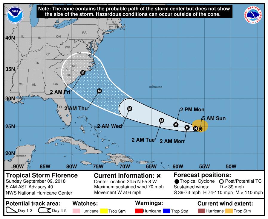
1 GENERAL OVERVIEW (significant forecast changes in red) Sunday Weather Briefing for September 9, 2018 Rains finish today in the far eastern Corn Belt with dry conditions across the region for the work-week period. No freezing temperatures through at least September 24 (probably longer) Not an overly wet 10-day/two-week forecast for the heart of the Mid-South. Powerful Hurricane Florence to strike the Carolinas on Thursday then stall for several days to create massive flooding. Cool in the Mid-South near term, warm for September 13-19, then cooler again Dry in the HRW wheat belt for the next 7-10 days then rains return. Cool near term, warm for September 13-16, then a little cooler again Periodic rains throughout the next two weeks in especially eastern parts of the northern Plains. No legitimate freeze threats though quite cool for around September 17 Very nice rains to fall in southern growing areas of Brazil for the 6-10/11-15 day periods while modest totals at best are seen further north Argentine rain chances for today through about Wednesday (decent though not overly big totals) Some significant rains this weekend in a part of the winter grain areas of the former Soviet Union and more to fall over the next ten days (forecast for Ukraine looks especially favorable) Below normal rainfall in Australian wheat areas the next two weeks Indian monsoon looks sub-normal the next two weeks


2 QPF Discussion Latest (i.e. early morning) 1-5 day precipitation forecast from the Weather Prediction Center. I have no disagreements with this forecast. Significant rains shown in the Corn Belt for Ohio are all for today, then even that area will join the dry conditions seen in the rest of the region for this time frame. A good part of the rain shown on this map for the heart of the Mid-South will be for today as well before that area sees more limited rains for the rest of this period. Note that the big rains shown in the Northeast as well as over southeastern Texas really have no tropical influences associated with them. The big rains shown in eastern North Carolina are with Hurricane Florence and will all fall on Thursday. Latest (i.e. early morning) Day 6-7 precipitation forecast from the Weather Prediction Center. Limited rains will continue in this period for a big part of the middle of the country, though a little rain will start to return on Saturday to far northwestern parts of the Corn Belt. Florence is expected to stall shortly after landfall and thus is expected to produce inundating rains for this period over Virginia and nearby areas.
3
, 6.91 at Mount Vernon (IL), 6.53 at Lawrenceville (IL), 6.37 at Huntingburg IN), and 6.20 at Bloomington (IN).")

4 CORN BELT: Radar-estimated rainfall for the past two days Biggest rainfall totals that I can find at major reporting stations (48-hour period ending 7 AM CDT) include 7.18 at St. Louis (downtown airport), 6.91 at Mount Vernon (IL), 6.53 at Lawrenceville (IL), 6.37 at Huntingburg IN), and 6.20 at Bloomington (IN). Rains will continue to be significant on this Sunday for extreme southeastern Indiana and much of Ohio with additional amounts there of (or even heavier than that for eastern Ohio). The rest of the region is going to be dry today, and even Ohio will join the rest of the Corn Belt in dry conditions for tomorrow through Friday. We will start to see some rain return to the far northwestern Corn Belt for Friday night as a cool front sags into that area, and that rain will likely start the western/northwestern Corn Belt into a daily threat of showers and thunderstorms that will last for the rest of the 6-10 day period. Favored areas for that rain would be northwestern Wisconsin, about the northwestern half of Iowa, eastern/northeastern Nebraska, the Dakotas, and Minnesota. Within that area I think that significant rain amounts can fall (and thus the call for above-normal totals for the 6-10 day time frame) and possibly even some locally heavy amounts. Rains would remain meager (or even nothing at all) during that time frame for the rest of the region. All of the Corn Belt would then have rain chances in the day period with western areas probably seeing the biggest totals. Freezing temperatures are not forecast for any location in the Corn Belt through September 24 (and probably a number of days beyond that). Temperatures will be cool for the next three days, then warm to easily abovenormal levels for Wednesday through the weekend. It will be cooler again for September (probably a lot
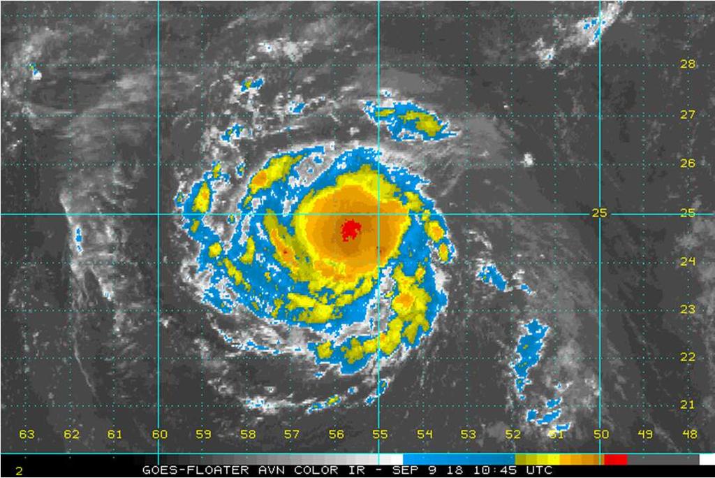
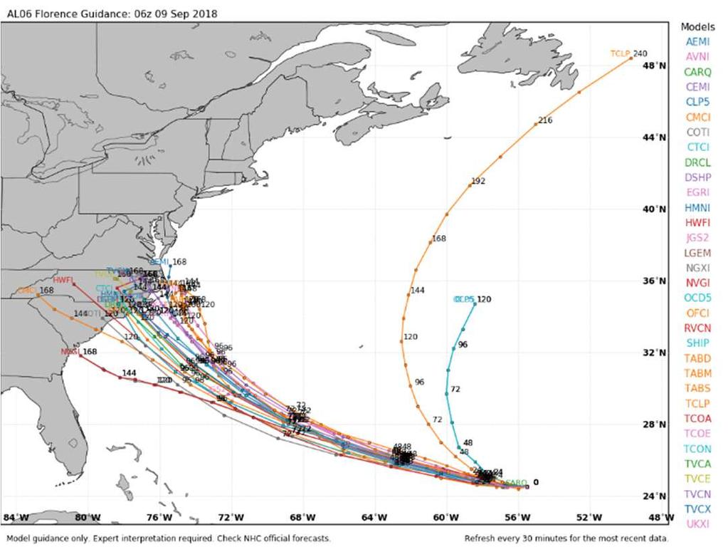
5 of 30s for lows in the Dakotas for September 17) but then likely warm again for the end of the current day period. MID-SOUTH/SOUTHEAST: The bulk of the rains are now behind us for northwestern parts of the Mid-South, but there will be additional significant rains in far southern Arkansas, Louisiana, Mississippi, and all but far western Tennessee. A lot of that rain will fall over the next 24 hours, with significant rains for the rest of the 1-5 day period confined to just southern parts of the Mid-South. I do not see the Mid-South as the focus for big rains in the 6-10 and day periods (probably normal or even below normal amounts). Florence remains a tropical storm at this time but is expected to regain hurricane status today and will become a major hurricane (CAT 3 or higher) tomorrow. It will continue to be a major hurricane through Thursday, expected to reach peak intensity for Tuesday night (peak winds of 145 mph at that time; near the middle of a CAT 4 rating) and will be either a strong CAT 3 or even a CAT 4 as it makes landfall near the SC/NC border or a little north of there on Thursday. The storm is then expected to become largely stationary for Friday and the weekend, and a result will produce all sorts of extreme flooding problems for large parts of North Carolina and Virginia ( inch rains in some areas have to be considered as a possibility). Mid-South temperatures will run cooler than normal through Tuesday, then will be easily above normal for September before moderating again. PLAINS HRW WHEAT/CATTLE FEEDLOT AREAS: Completely dry weather is expected across this area for at least the next week and possibly for a few days beyond that. Some rain chances will probably return towards the end of the 6-10 day period and rains look fairly significant in the day time frame. Temperatures will stay cool for another 2-3 days, then will be quite warm for September before moderating again. NORTHERN PLAINS: Periodic rains will be seen in this area throughout the two-week time frame; some of it will already be falling for late today and tonight. The rains in question will clearly favor the east versus the west, and in the east I am looking at 2-week rainfall totals of 1-2 for Minnesota and the eastern half of the Dakotas. Temperatures will be warm/very warm for the most part for today through Thursday. Some cooling will start to be seen in western/northwestern areas for Friday, and cool weather will be seen across the region by the end of the weekend and continue through about September 20. The period around September 17 will be the coolest, and I see the potential for a lot of 30s around a big part of the area for that morning. I do NOT see it as a widespread freeze situation, but can envision a few localized areas getting to 32 or a little lower. The day period will then end with temperatures returning to above-normal levels (so overall I do not see any big freeze threat in the region through September 24, and by that time we are getting pretty close to the date of the normal first fall freeze in a lot of the area).
6 INTERNATIONAL WEATHER It will be completely dry throughout all of the main corn/soybean growing areas of Brazil through Wednesday. Rains will start to return to parts of Rio Grande do Sul on Thursday and will spread throughout the southern growing areas of Brazil (and Paraguay) through the end of the 6-10 day period. At least some 1-2 rains will be seen for southern MGDS, Parana, Paraguay, and a good part of RGDS but I should be able to eventually identify areas more likely to see 2-3+ inch amounts. Conditions will remain quite favorable for more significant rain in that same area for the day time frame as well. We will start to see some rains in more northern corn/soybean areas of Brazil for around September 17 and beyond, though likely never real good rains for especially eastern Mato Grosso, Goias, Minas Gerais, and areas north of there (two-week rainfall totals in those areas will run below normal). There will be rains in Argentina over the next 24 hours in Buenos Aires, La Pampa, and far southern Cordoba, with a rain threat moving northward across all of the main corn/soybean/wheat areas for Tuesday night through Wednesday night. Rainfall totals for the 1-5 day time frame will be best in the west with a lot of amounts for Santa Fe, Cordoba, La Pampa, and central/western Buenos Aires. Rains do not look big anywhere in the region for the 6-10 day time frame but will increase some for the day period. There has been some rain this weekend in parts of the winter grain area of the former Soviet Union; I can find a couple spots in Ukraine that have had over an inch. There will be additional rains in the region for both the 1-5 and 6-10 day periods, and totals over the next ten days look quite good ( ) in a lot of Ukraine and in some parts of Southern District and North Caucasus District. Some additional rains may fall in the day period as well, favoring the same areas. Temperatures will continue to run easily above normal throughout the entire two-week forecast period. Rains will still not be very big in Europe over the next ten days with most of France, Germany, and Poland seeing under a half inch. Temperatures will be above normal. Rains for Chinese corn and soybean areas for the next two weeks will run close to normal in Manchuria and for the North China Plain. A lot of the area will see no rain at all for today through Wednesday. Weather looks very good for harvesting through Tuesday on the Canadian prairies for especially Alberta and Saskatchewan with those areas being largely dry. The rest of the 10-day forecast will see harvesting interrupted at times by rainfall throughout the region. Below normal rainfall is expected in all wheat areas of Australia over the next two weeks. It will be completely dry in most areas for today through at least Friday. The Indian monsoon does not look very good for the next two weeks. Especially dry conditions will be seen for the next ten days before some increase in the monsoon is forecast for the day period. Craig Solberg Craigsolberg@globalag.us
7 This report is intended for the recipient only. In no way or form should this be forwarded or reproduced to or for anyone. This commentary is for clients, affiliates, and associates of Nesvick Trading Group, LLC only. The information contained herein has been taken from trade and statistical services and other sources we believe are reliable. Opinions expressed reflect judgments at this date and are subject to change without notice. Nesvick Trading Group, LLC does not guarantee that such information is accurate or complete and it should not be relied upon as such. Officers, employees, and affiliates of Nesvick Trading Group, LLC may or may not, from time to time, have long or short positions in, and buy or sell, the securities and derivatives, if any, referred to in this commentary. There is risk of loss in trading futures and options and it is not suitable for all investors. PAST RESULTS ARE NOT NECESSARILY INDICATIVE OF FUTURE RETURNS. This document contains only commentary on economic, political, or market conditions and is not intended to be the basis for a decision to enter into any derivatives transaction. The contents of this commentary are for informational purposes only and under no circumstances should they be construed as an offer to sell or a solicitation to buy or sell any futures or options contract. No one has been authorized to distribute this for sale.
CropCast Daily Agro-Highlights Don Keeney Monday, April 25, 2016
 VHI Image Date: Apr 21, 2016 USA Wheat Corn Soybeans Vegetative Health Index Map and Crop Condition Tendency EUROPE Wheat Rapeseed FSU Wheat CHINA Wheat Rapeseed ARGENTINA Corn Soybeans BRAZIL Corn Soybeans
CropCast Daily Agro-Highlights Don Keeney Friday, April 22, 2016
 VHI Image Date: Apr 14, 2016 USA Wheat Corn Soybeans Vegetative Health Index Map and Crop Condition Tendency EUROPE Wheat Rapeseed FSU Wheat CHINA Wheat Rapeseed ARGENTINA Corn Soybeans BRAZIL Corn Soybeans
CropCast Daily Agri-Highlights Don Keeney Monday, July 25, 2016
 VHI Image Date: July 15, 2016 USA Corn Soybeans Vegetative Health Index Map and Crop Condition Tendency EUROPE Corn BLACK SEA INDIA Soybeans Groundnuts CHINA Corn Soybeans ARGENTINA BRAZIL Safrinha Corn
CropCast Corn and Soybean Report Kenny Miller Friday, March 17, 2017
 Accumulated Rainfall (inches) Accumulated GDDs Temperature ( F)/Wind Speed (mph) Precipitation (inches) CropCast Corn and Soybean Report Kenny Miller Friday, March 17, 2017 Peoria, IL Regional Forecast
CropCast Corn and Soybean Report Kyle Tapley Monday, March 20, 2017
 Accumulated Rainfall (inches) Accumulated GDDs Temperature ( F)/Wind Speed (mph) Precipitation (inches) CropCast Corn and Soybean Report Kyle Tapley Monday, March 20, 2017 Peoria, IL Regional Forecast
CropCast Corn and Soybean Report Kenny Miller Monday, March 13, 2017
 Accumulated Rainfall (inches) Accumulated GDDs Temperature ( F)/Wind Speed (mph) Precipitation (inches) CropCast Corn and Soybean Report Kenny Miller Monday, March 13, 2017 Peoria, IL Regional Forecast
CropCast Corn and Soybean Report Kenny Miller Tuesday, March 14, 2017
 Accumulated Rainfall (inches) Accumulated GDDs Temperature ( F)/Wind Speed (mph) Precipitation (inches) CropCast Corn and Soybean Report Kenny Miller Tuesday, March 14, 2017 Peoria, IL Regional Forecast
Weather Report 31 January 2018
 Weather Report 31 January 2018 South Africa - Weather The erratic rain pattern will continue on a frequent basis for the eastern half of South Africa during the coming week. Moisture totals through next
Weather Report 04 April 2018
 Weather Report 04 April 2018 South Africa - Weather Alternating periods of rain and sunshine will evolve across South Africa during the coming week. Moisture totals through next Tuesday morning will range
CropCast Weekly Feedgrains Report
 CropCast Weekly Feedgrains Report Don Keeney Thursday, CropCast Global Feedgrains Estimates AREA (m hectares) YIELD (kg/ha) PRODUCTION (mmt) CHANGE FROM LAST WEEK (mmt) 165.9 168.1 5695.4 5870.9 945.0
Weather Report 30 November 2017
 Weather Report 30 November 2017 South Africa - Weather The frequent precipitation pattern will continue for portions of eastern and central South Africa during the coming week. Moisture totals through
UNITED STATES AND SOUTH AMERICA OUTLOOK (FULL REPORT) Tuesday, December 19, 2017
 Tuesday, December 19, 2017") T-storm Weather Summary A series of cool fronts move across South America over the next 10 to 14 days, breaking drying across much of Argentina, southern Brazil, and Paraguay. That said, in Argentina,
T-storm Weather Summary A series of cool fronts move across South America over the next 10 to 14 days, breaking drying across much of Argentina, southern Brazil, and Paraguay. That said, in Argentina,
UNITED STATES AND SOUTH AMERICA OUTLOOK (FULL REPORT) Thursday, December 28, 2017
 Thursday, December 28, 2017") T-storm Weather Summary Despite scattered t-storms Sat.-Sun. in central and northern areas in Argentina, more will likely be needed especially in sunflower areas of the southwest. Some t-storms likely
T-storm Weather Summary Despite scattered t-storms Sat.-Sun. in central and northern areas in Argentina, more will likely be needed especially in sunflower areas of the southwest. Some t-storms likely
UNITED STATES AND SOUTH AMERICA WEATHER ROUNDUP Sunday, December 17, 2017
 T-storm Weather Summary Extreme heat was followed by heavy rain in some key areas of Argentina yesterday. T-storms affect much of the driest Argentina, southern Brazil, and Paraguay through 7 to 10 days,
Weather Report 29 November 2017
 Weather Report 29 November 2017 South Africa - Weather The erratic rain pattern will continue for portions of eastern and central India during the coming week. Moisture totals through next Tuesday morning
Crop / Weather Update
 Crop / Weather Update Corn Crop Condition Percent of Acreage Rated Good or Excellent 85 80 75 70 65 60 55 50 45 In its weekly Crop Progress Report for September 16, the USDA stated the 18-state average
Crop / Weather Update
 Crop / Weather Update Corn Crop Condition Percent of Acreage Rated Good or Excellent 85 80 75 70 65 60 55 50 45 As of September 9, USDA rates the crop at 68% good to excellent. The rating is up one point
Crop / Weather Update
 Crop / Weather Update Corn Crop Condition Percent of Acreage Rated Good or Excellent 85 80 75 70 65 60 55 50 45 The U.S. corn crop was rated 69% good-to-excellent on September 23, up 1% from week-ago,
HURRICANE HARVEY COE Navigation BRIEFING
 HURRICANE HARVEY COE Navigation BRIEFING 10:00 AM CDT Friday, August 25, 2017 NWSNewOrleans www.weather.gov/neworleans Situation Overview New Information Harvey continues to strengthen Max sustained winds
UNITED STATES AND SOUTH AMERICA SNAPSHOT REPORT Wednesday, December 20, 2017
 T-storm Weather Summary T-storms affect all growing areas of South America at one time or another over the next two weeks, but abovenormal rainfall is only likely for corn and soybeans in southern Brazil
TROPICAL STORM HARVEY BRIEFING
 TROPICAL STORM HARVEY BRIEFING 10:00 AM CDT Sunday, August 27, 2017 Prepared by: NWS LIX NWSNewOrleans www.weather.gov/neworleans Situation Overview New Information Tropical Storm Winds 40mph Immediate
Limited Showers Over the Next 10 Day Improves Harvest Conditions for the East but Wettest Areas in S. NSW Likely Remain Slow; Favorable W.
 Australia Limited Showers Over the Next 10 Day Improves Harvest Conditions for the East but Wettest Areas in S. NSW Likely Remain Slow; Favorable W. Harvest Australian Wheat/Canola A few light showers
UNITED STATES AND SOUTH AMERICA SNAPSHOT REPORT Thursday, December 21, 2017
 T-storm Weather Summary A small but key corn and soybean area in western Argentina was wetter than expected overnight. T-storms affect varying areas of South America at varying times into January, but
WeatherManager Weekly
 Issue 288 July 14, 2016 WeatherManager Weekly Industries We Serve Agriculture Energy/Utilities Construction Transportation Retail Our Weather Protection Products Standard Temperature Products Lowest Daily
TROPICAL STORM HARVEY BRIEFING
 TROPICAL STORM HARVEY BRIEFING 2:00 PM CDT Tuesday, August 29, 2017 Prepared by: NWS LIX NWSNewOrleans www.weather.gov/neworleans Situation Overview New Information Moving NNE Max sustained wind 45 mph
Global Weather Update
 WEST Global Weather Update Dry weather again dominated most of the western dairy areas last week. Temps ran above average as well, with highs in the 80 s and 90 s in the NW and 90 s and some 100 s in the
TROPICAL STORM HARVEY COE Navigation Call - Update
 TROPICAL STORM HARVEY COE Navigation Call - Update 10:00 AM CDT Tuesday, August 29, 2017 Prepared by: NWS LIX NWSNewOrleans www.weather.gov/neworleans Situation Overview New Information Drifting ENE at
Crop / Weather Update
 Crop / Weather Update This is our last for the 2018 planting, growing and harvesting seasons. USDA will publish their Crop Progress Report again in April 2019, and we will continue our coverage sometime
MIDDAY WEATHER SUMMARY
 MIDDAY WEATHER SUMMARY Weather Headlines TS Cindy will move inland tonight or early tomorrow morning near the Texas/Louisiana border. The latest GFS model run is cooler late in the 6-10 and early in the
Crop / Weather Update
 Crop / Weather Update Corn Crop Condition Percent of Acreage Rated Good or Excellent 85 80 75 70 65 60 55 50 45 Corn condition this week is the same as the last two weeks in the good/excellent category,
MDA WEATHER SERVICES AG WEATHER OUTLOOK. Kyle Tapley-Senior Agricultural Meteorologist May 22, 2014 Chicago, IL
 MDA WEATHER SERVICES AG WEATHER OUTLOOK Kyle Tapley-Senior Agricultural Meteorologist May 22, 2014 Chicago, IL GLOBAL GRAIN NORTH AMERICA 2014 Agenda Spring Recap North America Forecast El Niño Discussion
Weather Report 05 January 2018
 Weather Report 05 January 2018 South Africa - Weather Crop conditions will remain generally favorable across eastern South Africa during the next two weeks. Net drying will gradually reduce soil moisture,
TROPICAL DEPRESSION HARVEY BRIEFING
 TROPICAL DEPRESSION HARVEY BRIEFING 10:15 PM CDT Wednesday, August 23, 2017 Prepared by: Lara Beal NWSCorpus www.weather.gov/corpuschristi Situation Overview No changes to Watches. Hurricane Watch remains
Tropical Update. 5 PM EDT Thursday, September 7, 2017 Hurricane Irma, Hurricane Jose, and Hurricane Katia
 Tropical Update 5 PM EDT Thursday, September 7, 2017 Hurricane Irma, Hurricane Jose, and Hurricane Katia This update is intended for government and emergency response officials, and is provided for informational
UNITED STATES AND SOUTH AMERICA OUTLOOK (FULL REPORT) Wednesday, April 18, 2018
 Wednesday, April 18, 2018") T-storm Weather Summary Coolness continues over the next week in much of the central U.S., most likely producing the coldest April since 1907 in the Corn Belt, but followed by seasonable to mild weather
T-storm Weather Summary Coolness continues over the next week in much of the central U.S., most likely producing the coldest April since 1907 in the Corn Belt, but followed by seasonable to mild weather
Weekly Market Report 05 December 2018
 Weekly Market Report 05 December 2018 USD/ZAR Exchange rate: The Rand is currently quoted at R13.83 per US Dollar, 10 cents stronger in the last week. The Rand manged to break the support of the descending
Crop / Weather Update
 Crop / Weather Update The next will be published November 13, 2018, due to the Veteran s Day holiday on Monday. Corn Harvesting Progress 100% 90% 80% 70% 60% 50% 40% 30% 20% 10% 0% 9/9 9/16 9/23 9/30 10/7
Farm Futures Featured Story. Grainscoop I
 Grainscoop I From: Sent: To: Subject: The Farm Futures Team [farmfutures@farmprogres.ccsend.com] on behalf of The Farm Futures Team [farmfutures@farmprogress.com] Monday, July 15, 2013 2:46 PM grain@grainnotes.com
Winter Storm Tomorrow-Tomorrow Night
 Winter Storm Tomorrow-Tomorrow Night Decision Support Briefing #1 As of 4:30 PM Tuesday, February 19, 2019 What Has Changed? Initial Briefing Main Points Hazard Impacts Location Timing Snow Snow will create
NOAA s National Weather Service Philadelphia/Mt. Holly NJ
 Next Briefing Package: Friday, October 2, 2015 no later than 300 PM Hazards and Impacts: Overview: A dangerous weather pattern still threatens our region. Threats include very heavy rainfall, inland river
Atlantic Basin Satellite Image
 Tropical Update 11 AM EDT Friday, September 7, 2018 Tropical Depression Gordon, Tropical Storm Florence, Potential Tropical Cyclone #8 (90%), Invest 92L (90%) This update is intended for government and
Crop / Weather Update
 Crop / Weather Update We would like to welcome you to another season of Doane s Weekly Crop Weather Update Progress Chartbook. The goal is to provide a quick visual overview of a number of the key gauges
Significant Flooding Expected
 Significant Flooding Expected Decision Support Briefing #5 As of: 9:00 AM September 14, 2018 What Has Changed? Flash Flood Watch now in effect for part of area, will be expanded later today 9/14/2018 9:23
Tropical Update. 11 AM EDT Tuesday, October 9, 2018 Hurricane Michael, Tropical Storm Leslie, Tropical Storm Nadine
 Tropical Update 11 AM EDT Tuesday, October 9, 2018 Hurricane Michael, Tropical Storm Leslie, Tropical Storm Nadine This update is intended for government and emergency response officials, and is provided
Hurricane Harvey: SE Texas Impacts. 10 PM CDT UPDATE Friday, August 25, 2017 Prepared by: Lance Wood
 Hurricane Harvey: SE Texas Impacts 10 PM CDT UPDATE Friday, August 25, 2017 Prepared by: Lance Wood Latest Observations Hurricane Harvey making landfall this evening near Rockport as a category 4 hurricane.
GC Briefing. Weather Sentinel Hurricane Florence. Status at 5 PM EDT (21 UTC) Today (NHC) Discussion. September 13, 2018
 Today (NHC) Discussion. September 13, 2018") GC Briefing September 13, 2018 Weather Sentinel Hurricane Florence Tropical storm conditions have been reported for areas of North Carolina and will continue to spread inland to the west and south. Hurricane
GC Briefing September 13, 2018 Weather Sentinel Hurricane Florence Tropical storm conditions have been reported for areas of North Carolina and will continue to spread inland to the west and south. Hurricane
Crop / Weather Update
 Crop / Weather Update Corn Crop Condition Percent of Acreage Rated Good or Excellent 85 80 75 70 65 60 55 50 45 Corn condition this week is the same as last week in the good/excellent category, which is
NatGasWeather.com Daily Report
 NatGasWeather.com Daily Report Issue Time: 5:15 am EDT Wednesday, March 22 nd, 2017 1-7 Day Weather Summary (Mar 22-28 th ): A cold blast will sweep across the Great Lakes and eastern US today and Thursday
TROPICAL STORM NATE BRIEFING
 TROPICAL STORM NATE BRIEFING 5:00 AM CDT Friday, October 6, 2017 Prepared by: NWS NWSNewOrleans www.weather.gov/neworleans Situation Overview No significant changes to the track forecast this morning.
Tropical Update 11 AM EDT Thursday, September 6, 2018 Tropical Depression Gordon, Hurricane Florence, Invest 92L (90%) & African Tropical Wave (50%)
 & African Tropical Wave (50%)") Tropical Update 11 AM EDT Thursday, September 6, 2018 Tropical Depression Gordon, Hurricane Florence, Invest 92L (90%) & African Tropical Wave (50%) This update is intended for government and emergency
Tropical Update 11 AM EDT Thursday, September 6, 2018 Tropical Depression Gordon, Hurricane Florence, Invest 92L (90%) & African Tropical Wave (50%) This update is intended for government and emergency
Tropical Update. 5 AM EDT Thursday, September 7, 2017 Hurricane Irma, Hurricane Jose, and Hurricane Katia
 Tropical Update 5 AM EDT Thursday, September 7, 2017 Hurricane Irma, Hurricane Jose, and Hurricane Katia This update is intended for government and emergency response officials, and is provided for informational
The Canadian Agriculture Weather Prognosticator
 TO SUBSCRIBE CALL 913-383-1161 OR WRITE TO WORLDWEHER@BIZKC.RR.COM The Canadian Agriculture Weather Prognosticator Volume VIII, Issue XIIII http://www.worldweather.cc November 3, 2016 Canada Crop Weather
IWT Scenario 1 Integrated Warning Team Workshop National Weather Service Albany, NY October 31, 2014
 Integrated Warning Team Workshop National Weather Service Albany, NY October 31, 2014 23 24 25 26 27 Scenario 1 Timeline November 23-27 Sun Mon Tue Wed Thu Thanksgiving Day Sunday, Nov. 23 @ 430 pm NWS
WEATHER NOTIFICATION STATEMENT
 WEATHER NOTIFICATION STATEMENT NEW DATA SHOWS SNOWSTORM THREAT FOR JAN 13-14 LOOKS MUCH HEAVIER BIGGER COVERAGE northwest NC (ice) ALL OF VA (Except Hampton Roads) all of MD/ DEL eastern southern PA southern
Weekly Weather Briefing. NWS Albuquerque. Tuesday Soaker. NWS Albuquerque August 25, Weekly Weather Briefing
 Weekly Weather Briefing Weekly Weather Briefing Tuesday Soaker August 25, 2014 August 2014 vs. 2013 Precipitation Percent of Average August 1-24, 2014 August 2013 Weekly Weather Briefing ABQ **Preliminary**
WeatherManager Weekly
 Issue 222 March 26, 2015 Welcome to this week s WeatherManager, your weekly journal for ideas and developments in the weather risk market, brought to you by eweatherrisk. Articles talk about the expanding
HEADLINES ** 2 ND FROST POSSIBLE FOR THE SHEANANDOAH VALLEY THURSDAY MORNING 4/17??***
 HEADLINES DATA SHOWS CLOUDS WINDS VERY LOW DEW POINTS OVER NIGHT WHICH MAY SAVE THE DAY AND PREVENT MAJOR FROST FREEZE IN SOME AREAS WEDNESDAY MORNING ** 2 ND FROST POSSIBLE FOR THE SHEANANDOAH VALLEY
Tropical Update. 5 PM EDT Sunday, October 7, 2018 Tropical Storm Michael, Tropical Storm Leslie, & Invest 92L (30%)
") Tropical Update 5 PM EDT Sunday, October 7, 2018 Tropical Storm Michael, Tropical Storm Leslie, & Invest 92L (30%) This update is intended for government and emergency response officials, and is provided
Tropical Update 5 PM EDT Sunday, October 7, 2018 Tropical Storm Michael, Tropical Storm Leslie, & Invest 92L (30%) This update is intended for government and emergency response officials, and is provided
January 2006 Climate Summary
 Ashley Brooks (765) 494-6574 Feb 9, 2006 http://www.iclimate.org January 1-3 January 2006 Climate Summary Unseasonably warm conditions welcomed in the New Year with highs in the 40s across the northern
DISCUSSION --1/ 4 /19
 ISSUED: 4 JNURY 1715 EST WXRISK VIDEO WINTER FORECST short version WXRISK VIDEO WINTER FORECST Long version DISCUSSION --1/ 4 /19 *** STRONG SIGNS OF RETURN TYPICL JNURY TEMPS... DEVELOPING FTER JN 9 ***
Major Winter Storm to impact Western Washington. 17 January 2012 National Weather Service Seattle/Tacoma
 Major Winter Storm to impact Western Washington 17 January 2012 National Weather Service Seattle/Tacoma Current Warnings Winter Storm Warning for all of Western Washington, except: Northwest interior Extreme
Tropical Update. 1 PM EDT Monday, May 21, 2018 Caribbean Disturbance (20%)
") Tropical Update 1 PM EDT Monday, May 21, 2018 Caribbean Disturbance (20%) This update is intended for government and emergency response officials, and is provided for informational and situational awareness
Tropical Update 1 PM EDT Monday, May 21, 2018 Caribbean Disturbance (20%) This update is intended for government and emergency response officials, and is provided for informational and situational awareness
Hurricane Harvey: SE Texas Impacts. 10 AM CDT UPDATE Saturday, August 26, 2017 Prepared by: Dan Reilly, Brian Kyle
 Hurricane Harvey: SE Texas Impacts 10 AM CDT UPDATE Saturday, August 26, 2017 Prepared by: Dan Reilly, Brian Kyle Latest Observations and Radar Hurricane Harvey centered near Victoria and weakening Wind
Monday, October 19, CDT Brian Hoeth
 Monday, October 19, 2015 1400 CDT Brian Hoeth Some of the briefing presented is worstcase scenario and may differ in detail from local NWS Weather Forecast Offices. National Weather Service Southern Region
Active Weather Threat Halloween Week Nor easter October 28 th 31 st 2012
 Active Weather Threat Halloween Week Nor easter October 28 th 31 st 2012 Prepared 1130 AM EDT Wednesday, October 24, 2012 Gary Szatkowski NOAA s NJ Forecast Office Weather.gov/phi Purpose of Briefing Briefing
IWT Scenario 2 Integrated Warning Team Workshop National Weather Service Albany, NY October 31, 2014
 IWT Scenario 2 Integrated Warning Team Workshop National Weather Service Albany, NY October 31, 2014 09 10 11 12 13 Scenario 2 Timeline December 9-13 Tue Wed Thu Fri Sat Tue, Dec. 9 @ 5 am 2014 2014 2014
STILL HOT & DRY WEATHER IN ARGENTINA WITH POSSIBLE RAIN IN THE FORECAST FOR NEXT WEEK
 Page 1 of 6 RICK ALEXANDER, MARKET STRATEGIST ZANER GROUP STILL HOT & DRY WEATHER IN ARGENTINA WITH POSSIBLE RAIN IN THE FORECAST FOR NEXT WEEK Higher closes for Minneapolis, Kansas City and Chicago wheat
NOAA s National Weather Service Philadelphia/Mt. Holly NJ
 Next Briefing Package: Thursday, October 1, 2015 no later than 300 PM Hazards and Impacts: Overview: A dangerous weather pattern is developing for our region. Threats include very heavy rainfall, inland
Tropical Update. 5 PM EDT Tuesday, September 5, 2017 Hurricane Irma, Tropical Storm Jose, and Tropical Depression Thirteen
 Tropical Update 5 PM EDT Tuesday, September 5, 2017 Hurricane Irma, Tropical Storm Jose, and Tropical Depression Thirteen This update is intended for government and emergency response officials, and is
Weather and Climate Risks and Effects on Agriculture
 Weather and Climate Risks and Effects on Agriculture Dr. Eric Snodgrass Official Journal of the Fluid Fertilizer Foundation Vol. 26, No. 2, Issue #100 DOWNLOAD Summary: So, what do we need to watch for?
NatGasWeather.com Daily Report
 NatGasWeather.com Daily Report Issue Time: 5:15 pm EST Sunday, February 28 th, 2016 for Monday, Feb 29 th 7-Day Weather Summary (February 28 th March 5 th ): High pressure will dominate much of the US
MORNING WEATHER SUMMARY
 MORNING WEATHER SUMMARY Weather Headlines Hot weather will prevail across the West into next week while another shot of cooler air moves into the eastern US. The 6-10 day period was trended slightly warmer
WeatherManager Weekly
 Issue 237 July 9, 2015 Welcome to this week s WeatherManager, your weekly journal for ideas and developments in the weather risk market, brought to you by eweatherrisk. The articles talk about the volatile
Winter Storm Saturday into Sunday December 14-15, 2013
 Winter Storm Saturday into Sunday December 14-15, 2013 Prepared 900 AM EST Friday December 13, 2013 Al Cope NOAA s NJ Forecast office http://www.erh.noaa.gov/phi/ Purpose of Briefing Briefing #3 for event.
WEEKLY OUTLOOK Valid: June 24-July 1, 2013
 WEEKLY OUTLOOK Valid: June 24-July 1, 2013 Issue: 6:00 am Tuesday, June 24, 2013 SYNOPSIS for 6:00am Tuesday, June 24, 2013 RESIDUAL INSTABILITY IN THE MOIST EASTERLY AIRFLOW INDUCED BY A SHORT-WAVE TROUGH
WeatherManager Weekly
 Issue 242 August 13, 2015 Welcome to this week s WeatherManager, your weekly journal for ideas and developments in the weather risk market, brought to you by eweatherrisk. The articles talk about the volatile
Weather and Climate Summary and Forecast August 2018 Report
 Weather and Climate Summary and Forecast August 2018 Report Gregory V. Jones Linfield College August 5, 2018 Summary: July 2018 will likely go down as one of the top five warmest July s on record for many
Tropical Storm Harvey: SE Texas Impacts
 Tropical Storm Harvey: SE Texas Impacts 10 AM CDT UPDATE Thursday, August 24, 2017 Prepared by: Dan Reilly, Brian Kyle PLEASE MUTE YOUR LINES AND DON T PUT ON HOLD! Situation Overview Tropical Storm Harvey
Hydrologic Briefing Tropical Storm Harvey
 Hydrologic Briefing Tropical Storm Harvey 5:00 PM CDT Sunday, August 27, 2017 Prepared by: Jennifer Dunn/Christina Barron NWSCorpus www.weather.gov/corpuschristi Situation Overview Tropical Storm Harvey
GC Briefing. Weather Sentinel Tropical Storm Michael. Status at 8 AM EDT (12 UTC) Today (NHC) Discussion. October 11, 2018
 Today (NHC) Discussion. October 11, 2018") GC Briefing Weather Sentinel Tropical Storm Michael October 11, 2018 After making landfall as a high-end category-4 hurricane on the Florida Panhandle, Michael weakened to tropical storm status early this
GC Briefing Weather Sentinel Tropical Storm Michael October 11, 2018 After making landfall as a high-end category-4 hurricane on the Florida Panhandle, Michael weakened to tropical storm status early this
U.S. Outlook For October and Winter Thursday, September 19, 2013
 About This report coincides with today s release of the monthly temperature and precipitation outlooks for the U.S. from the Climate Prediction Center (CPC). U.S. CPC October and Winter Outlook The CPC
National Wildland Significant Fire Potential Outlook
 National Wildland Significant Fire Potential Outlook National Interagency Fire Center Predictive Services Issued: September, 2007 Wildland Fire Outlook September through December 2007 Significant fire
WEDNESDAY 30 TH AUGUST, :57 p.m. Tropical Storm Irma forms in the Atlantic. Don t let your guard down, always #Be Ready.
 Chapter 1 - The Set Up In the days leading up to Irma a series of composed and sobering text messages, presented in truncated form below, from Department of Disaster Management warned us of the pending
Tropical Update. 5 PM EDT Sunday, September 10, 2017 Hurricane Irma, Hurricane Jose, Tropical Wave (60%)
") Tropical Update 5 PM EDT Sunday, September 10, 2017 Hurricane Irma, Hurricane Jose, Tropical Wave (60%) This update is intended for government and emergency response officials, and is provided for informational
Tropical Update 5 PM EDT Sunday, September 10, 2017 Hurricane Irma, Hurricane Jose, Tropical Wave (60%) This update is intended for government and emergency response officials, and is provided for informational
Tropical Update. 11 AM EDT Wednesday, October 10, 2018 Hurricane Michael, Hurricane Leslie & Tropical Storm Nadine, Caribbean Low (40%)
") Tropical Update 11 AM EDT Wednesday, October 10, 2018 Hurricane Michael, Hurricane Leslie & Tropical Storm Nadine, Caribbean Low (40%) This update is intended for government and emergency response officials,
Tropical Update 11 AM EDT Wednesday, October 10, 2018 Hurricane Michael, Hurricane Leslie & Tropical Storm Nadine, Caribbean Low (40%) This update is intended for government and emergency response officials,
Tropical Update. 5 AM EDT Monday, October 8, 2018 Tropical Storm Michael, Tropical Storm Leslie, Invest 92L (10%) & African Tropical Wave (50%)
 & African Tropical Wave (50%)") Tropical Update 5 AM EDT Monday, October 8, 2018 Tropical Storm Michael, Tropical Storm Leslie, Invest 92L (10%) & African Tropical Wave (50%) This update is intended for government and emergency response
Tropical Update 5 AM EDT Monday, October 8, 2018 Tropical Storm Michael, Tropical Storm Leslie, Invest 92L (10%) & African Tropical Wave (50%) This update is intended for government and emergency response
By: J Malherbe, R Kuschke
 2015-10-27 By: J Malherbe, R Kuschke Contents Summary...2 Overview of expected conditions over South Africa during the next few days...3 Significant weather events (27 October 2 November)...3 Conditions
Hydrologic Briefing Tropical Storm Harvey
 Hydrologic Briefing Tropical Storm Harvey 10:30 AM CDT Sunday, August 27, 2017 Prepared by: John Metz NWSCorpus www.weather.gov/corpuschristi Situation Overview Tropical Storm Harvey Harvey to remain a
A Complex Weather System: Tuesday Afternoon into Thursday March 3 5, 2015
 A Complex Weather System: Tuesday Afternoon into Thursday March 3 5, 2015 Briefing #1, prepared 900 AM EST Tuesday, March 3, 2015 by Meteorologists at NWS - WFO Mount Holly, NJ To promote situational awareness
Weekly Market Report 25 July 2018
 Weekly Market Report 25 July 2018 USD/ZAR Exchange rate: The Rand is currently quoted at R13.28 per US Dollar, 3 cents stronger in than last week. The Rand weakend initially as expected but managed to
2018 mid-winter ag weather update
 E-book Bryce Anderson s 2018 mid-winter ag weather update Table of contents Contributing weather patterns... 3 About the author An updated mid-winter forecast... 4 Early expectations for the growing season...
MARTINSON AG. Jan. 5, 2018 WHEAT
 MARTINSON AG Jan. 5, 2018 WHEAT Wheat started the short week with strength and closing with solid gains. Early support came from the past weekend s extremely cold temps, as even KS and OK reported temps
Tropical Update. 5 AM EDT Wednesday, September 6, 2017 Hurricane Irma, Tropical Storm Jose, and Tropical Storm Katia
 Tropical Update 5 AM EDT Wednesday, September 6, 2017 Hurricane Irma, Tropical Storm Jose, and Tropical Storm Katia This update is intended for government and emergency response officials, and is provided
March 19th, By Jack Scoville
 March 19th, 2018 By Jack Scoville Wheat: Wheat markets were lower on Friday as forecasts for beneficial rains in the western Great Plains, mostly in Kansas for the first part of this week were maintained.
TROPICAL STORM NATE BRIEFING
 TROPICAL STORM NATE BRIEFING 2:00 PM CDT Friday, October 06, 2017 Prepared by: NWS NWSNewOrleans www.weather.gov/neworleans Situation Overview Track forecast has not changed since the 10 am advisory. Hurricane
Custom Weather Forecast
 1 of 23 Custom Weather Forecast 2018 Chicago Yacht Club s Race To Mackinac- Cruising Division Disclaimer: The user assumes all risk related to the use of this Custom Weather Forecast. The crew of the participating
TROPICAL STORM NATE BRIEFING
 TROPICAL STORM NATE BRIEFING 10:30 AM CDT Friday, October 06, 2017 Prepared by: NWS NWSNewOrleans www.weather.gov/neworleans Situation Overview Track forecast has shifted slightly eastward. Hurricane Watch
Weekly Weather Briefing. NWS Albuquerque. Wet, Then Dry, Then Wet. NWS Albuquerque August 4, Weekly Weather Briefing
 Weekly Weather Briefing Weekly Weather Briefing Wet, Then Dry, Then Wet August 4, 2014 Weekly Weather Briefing Most Recent Temperatures Weekly Weather Briefing Today s Max Temp Departure from Normal Weekly
Weekly Weather. Flash. Europe. September 18 October 1
 Weekly Weather September 18 October 1 Flash US THIS WEEK: The Official Start of Fall Brings Cooler Temperatures to the West, While the East Holds On to the Heat; Rain Expected Across the Northern Tier
MARKET WIRE. Jason Vollmer (701) Trygg Olson (701) Nick Smith (701) Adam Allmaras (701)
 Trygg Olson (701) Nick Smith (701) Adam Allmaras (701)") MARKET WIRE Quick Notes: New news in the corn market is limited. Markets continue to see spillover from Friday s USDA report. Carryout was unchanged in Friday s report and exports continue to remain sluggish.
MARKET WIRE Quick Notes: New news in the corn market is limited. Markets continue to see spillover from Friday s USDA report. Carryout was unchanged in Friday s report and exports continue to remain sluggish.