Intraseasonal TC Variability and Seasonal Hurricane Forecasting
|
|
|
- Jonathan Fields
- 5 years ago
- Views:
Transcription


1 Intraseasonal TC Variability and Seasonal Hurricane Forecasting 2018 WMO Class Eric Blake Hurricane Specialist National Hurricane Center 2/28/2018
2 Outline Madden-Julian Oscillation (MJO) MJO analysis tools Kelvin Waves Seasonal forecasting Exercise Brief look at 2018
3 Question 1 What s the 3rd busiest month on average in terms of Atlantic ACE? A. July B. August C. September D. October

4 No Storm Formations in 2008
5 Madden-Julian Oscillation Discovered in the early 1970s by Roland Madden and Paul Julian. An eastward propagating wave that circles the globe in about days involving tropical convection. Detected in the Outgoing Longwave Radiation (OLR) and wind fields across the tropics. Later papers showed that it is an important modulator of TC activity, especially in the Pacific Ocean.
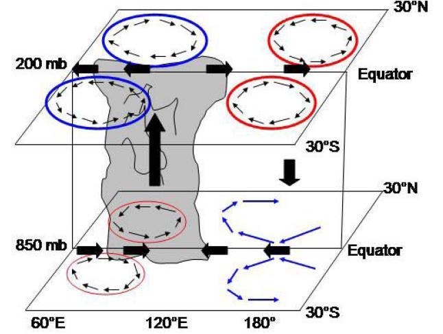
6 -Idealized Diagram of the day Tropical Intraseasonal Oscillation -Became known as the Madden-Julian Oscillation in the late 1980s -Generally forms over the Indian Ocean, strengthens over the Pacific Ocean and weakens due to interaction with South America and cooler eastern Pacific SSTs (Madden and Julian 1972)
7

8 Daily Rainfall (mm)

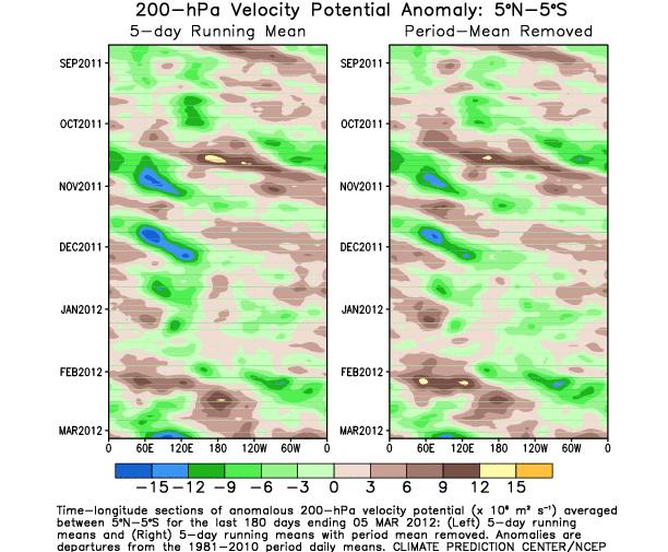
9 200 mb Velocity Potential fields one way to track the MJO Blue= divergence Red= convergence Center of the blue area tracks the most upper divergence, which is usually well-linked to thunderstorms
10
 In western hemisphere, upper-level signal usually much easier to track than")
11 MJO characteristics Note signal is much stronger in eastern Hemisphere than western Eastward phase speed is a lot slower in eastern than western Hemi (convective coupling) In western hemisphere, upper-level signal usually much easier to track than lower-level

12 10-day ECMWF MJO Forecast
13 MJO Effects in the Atlantic Basin The MJO can lose much of its strength before entering the Atlantic basin. In addition, the MJO is weakest during the late summer, near the peak of Atlantic activity. Western part of the basin most strongly affected (Maloney and Hartmann 2000).

 Inactive MJO EOF and corresponding TS")


14 Active MJO EOF and corresponding TS and H tracks Active MJO in the western Caribbean Sea and Gulf of Mexico produces more storms due to: Increase in low-level convergence (ITCZ moves farther north) Inactive MJO EOF and corresponding TS and H tracks Low-level vorticity is also increased due to westerly low-level flow meeting easterly trades Upper divergence is stronger than average during the westerly phase, with a drop in shear as well Adapted from Maloney and Hartmann (2000)

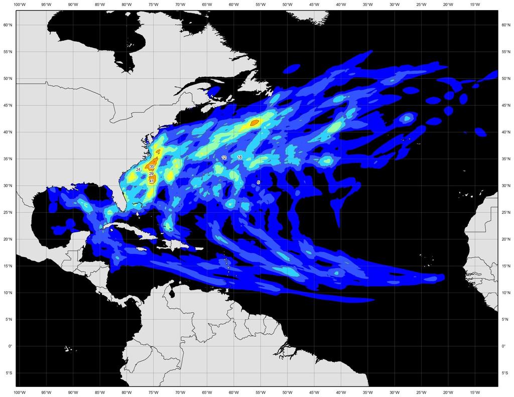
15 Most genesis points are near or behind the upperlevel divergence center.
16 A different way to visualize the MJO The axes (RMM1 and RMM2) represent daily values of the principal components from the two leading modes, following the active convection. The triangular areas indicate the location of the enhanced phase of the MJO Counter-clockwise motion is indicative of eastward propagation Distance from the origin is proportional to MJO strength Line colors distinguish different months

17 Current MJO: Plan view versus RMM diagram
18

19 200 mb Velocity Potential fields one way to track the MJO Blue= ~divergence Red= ~convergence Center of the blue area tracks the most upper divergence, which is usually well-linked to thunderstorms
20 Question 2 What phases of the MJO are most favorable for Atlantic TC activity? A. Phases 3/4 B. Phases 5/6 C. Phases 7/8 D. Phases 1/2
21 Normalized Activity by MJO Phase ( ) MJO Phase NS NSD H HD MH MHD ACE Phase Phase Phase Phase Phase Phase Phase Phase Ratio of Phases 1+2 to Phases From Klotzbach (2010)

22 850-hPa Vector Wind Anomalies (m s-1) Note that shading denotes the zonal wind anomaly Blue shades: Easterly anomalies Red shades: Westerly anomalies Typical Active Atlantic pattern (if in summer-time)!
23 All Genesis Points MJO Phases 1+2 MJO Phases 6+7
24 36 Major Hurricanes 13 Major Hurricanes

25 10 Hurricane Landfalls 1 Hurricane Landfall MJO Phase 2 MJO Phase 7

 & Carl")
26 Kelvin Waves & Tropical Cyclones Adapted from: Michael Ventrice (TWC), Kyle Griffin (UW) & Carl Schreck (NCICS)
27 Background The idea of equatorial waves interacting with TCs is relatively new - An objective method of tracking equatorial waves in real-time wasn t published until First AMS papers mentioning (atmospheric) equatorial waves and TCs appeared around Number of papers that involve this or similar topics in AMS journals only number in the ~2 dozen range Equatorial waves aid in enhanced predictability of TC genesis several (3-7) days into the future.
 Alternating westerlies and easterlies on the equator Enhanced convection where low-level winds converge Active phase associated with latent heating")

28 Kelvin Waves Convergence Divergence Negative OLR Positive OLR Matsuno (1966) Kiladis et al. (2009) Alternating westerlies and easterlies on the equator Enhanced convection where low-level winds converge Active phase associated with latent heating & the generation of low-level relative vorticity due to presence of meridional flow Modifies ITCZ convection, which causes significant changes to a system s local environment NASA PMM Science Meeting October 2016, Houston, TX NASA PMM Grant NNX13AH47G Propagation: Eastward Phase speed: m s 1 Period: Wavelength: 3 10 days km Adapted from Carl Schreck
29 MJO vs. KW The Madden-Julian Oscillation (MJO) consists of an active and suppressed phase, dominated by low-level westerly and easterly anomalies, respectively. Convection is preferred in the active phase. A typical MJO moves eastward at 4 to 8 m s -1 with a zonal extent that spans planetary to synoptic scales. A Kelvin wave is spatially very similar to the MJO, but is typically observed at higher zonal wavenumbers and moves eastward at m s -1. Effects are more constrained within the Tropics and associated wind anomalies are spatially smaller than the MJO. Adapted from Griffin (2014)

30 Tropical wave + CCKW composite East Pacific: 40 storms Storm-relative Totals Composite Hovmöllers of storms forming at the most favorable lags (2-3d) from Kelvin wave crest The wave is invigorated with convection/rainfall, leading to genesis. CCKW most effective when some westerly flow already present NASA PMM Science Meeting October 2016, Houston, TX NASA PMM Grant NNX13AH47G 32


31 Kelvin Waves, MJO and Tropical Cyclogenesis Storms typically form 0 3 days after the Kelvin wave s convective peak Easterly wave amplifies in the Kelvin wave/mjo convective envelope Timing of genesis can be strongly influenced by the Kelvin Wave in positive MJO Schreck (2015, MWR) Background Vertical Horizontal Summary NASA PMM Science Meeting October 2016, Houston, TX NASA PMM Grant NNX13AH47G 33

32 Vertical Structure East Pacific Zonal Wind Eq 10 N Convection and storm-relative westerlies intersect easterly wave 2 days before genesis Easterly wave circulation builds upward as the Kelvin wave propagates Kelvin tilt might explain lag in genesis from convection 400-hPa is 30 longitude behind 850- hpa Kelvin speed of 15 m s 1 gives a 2.5-day lag between 850 hpa and 400 hpa NASA PMM Science Meeting October 2016, Houston, TX NASA PMM Grant NNX13AH47G 35

33 Atlantic CCKWs and genesis t -t Tropical cyclogenesis events over the MDR (5-25 N, W) relative to the CCKW during June-September Day 0 highlights the transition to statistically significant negative unfiltered OLR anomalies, or the eastern-most side of the convectively active phase of the CCKW. Error bars indicate the 95% confidence interval.
34 Atlantic CCKWs and genesis Tropical cyclogenesis relative to the Kelvin wave

35 10-day ECMWF forecast of CCKWs

36 Yet another strong CCKW is moving across the eastern Pacific This system should move through the eastern Pacific within the next few days, with genesis possible in the far eastern Pacific Days 3-5. Ana & Trudy form 51

37 Ana Trudy 52
38 Operational challenges Real-world CCKWs have day-to-day weather patterns overlaid on them, making them harder to recognize. When making genesis forecasts for a particular system, any CCKW information must be taken in context with the entire weather situation. Knowledge about the base state (~120 d mean or ENSO), MJO phase, climatology and numerical weather models must all be considered in concert with CCKW interactions. For example, if the base state is extremely unfavorable, can it overcome other enhancing factors? (e.g. most of the 2014 Atlantic hurricane season, 2015 EPac is the counter example) 54
39 Current NHC practices No operational standard on use of CCKW in genesis forecasts (about half of forecasters use it). It is believed that global models handle the MJO much more accurately than individual CCKWs (too much dampening), and thus the forecaster can add value to the deterministic models. Any adjustments to 5-day genesis probabilities are small and subjectively determined. Also used as a way to increase forecaster confidence in a given situation if conceptual model of CCKWs and genesis matches model solutions. 55
40 Operational long-range TC forecasts CPC, in combination with other NOAA/federal/university partners, issues a week 1 and week 2 possible TC risk areas (in addition to other global hazards) These global forecasts are released Tuesday afternoons The TC-only forecasts are updated on Friday afternoons, if necessary, for the Atlantic/E Pacific only during week 1/2 56
41 Matthew x
42 Seasonal Forecasting

43 Seasonal Forecasting is more than this!
44 Short history of NOAA seasonal hurricane forecasting The Climate Prediction Center (CPC) began issuing Atlantic seasonal hurricane forecasts after the Gray 1997 forecast bust. Outlooks issued in late May and early August. Collaborative effort between the CPC, National Hurricane Center and Hurricane Research Division. Outlooks are a qualitative combination of statistical and dynamical tools, but have become more quantitative over time.
45 El Niño Warming of the equatorial waters in the central and eastern Pacific every 3-5 years Changes global atmospheric circulation by altering low-latitude deep convection. Moderate/strong events generally cause a reduced Atlantic season Weaker events have little relationship to Atlantic hurricane activity

46 Composite of tropical cyclone tracks during 14 moderate to strong El Niño years versus the next year El Niño Years Year after El Niño From Gray 1984

47 Niño regions Nino 3.4 region generally has the strongest relationship with Atlantic hurricane activity.

48 El Niño La Niña


49 El Niño versus La Niña Upper winds Hello there it Convection shifted eastward during El Niño causes more shear and sinking air over the Atlantic. Upper winds Convection shifted westward during La Niña causes less sinking air and shear over the Atlantic.
50 El Niño
51 La Niña
52 Vertical Wind Shear Tropical cyclones generally require low vertical wind shear to develop, less than about 20 mph. Early-season vertical shear (June-July) relates well to August-October shear (peak season). Since 90% of the season is usually after 1 August, useful to update then.


53 200 mb (~40,000 ft) Climatology is for lots of shear during hurricane season 850 mb (~5,000 ft)
54 Vertical Wind Profile in the Main Development Region (10-20 N; W) a b TROPOPAUSE (16 km) a fewer TCs (El Niño) b more TCs (La Niña) Zonal Wind (u) ms -1
55 Sea-Surface Temperatures (SSTs) Warmer Atlantic waters generally mean a more active hurricane season. Relative warmth of Atlantic to global tropics also important. Higher SSTs lead to more instability in the boundary layer of the atmosphere. Changes in SST gradients modulates regional circulation. Atlantic SSTs also atmospheric proxy. Cooler waters are linked to higher surface pressures, stronger surface winds (higher shear as a result) and upwelling.

56 Correlation between Atlantic SST and Atlantic Hurricane Activity

57 Composite map of June-July SST anomalies during 10 active hurricane seasons Colder than average Warmer than average
 feedback mechanism Strongest signal during the spring, but persists into hurricane season J. P. Kossin, 2008 AMS Annual Meeting")
58 The Atlantic Meridional Mode: SST, wind, and precip anoms Leading mode of basinwide ocean-atmosphere interaction between SST and low-level winds Amplifies via the wind-evaporation-sst (WES) feedback mechanism Strongest signal during the spring, but persists into hurricane season J. P. Kossin, 2008 AMS Annual Meeting

59 Comparative effects of the AMM (local) and ENSO (remote) on vertical wind shear in the Atlantic units: m/s per standard deviation Shear regressed onto AMM and N34 indices, and correlations between the indices and storm activity. J. P. Kossin, 2008 AMS Annual Meeting
 AMM 4.")
60 Forcing the AMM SLP anomaly associated with (+) NAO L 1. Subtropical SLP anomalies associated with NAO H H 2. Cool SST through enhanced evaporation (stronger easterlies) 3. Atmosphere responds through anticyclonic circulation, reinforcing wind anomalies (-) AMM 4. Resulting feedback can last for several months, even after NAO forcing subsides [FLIP sign for (-) NAO] Courtesy Dima Smirnov ESRL
 Weak trades excite a positive AMM for the summer, leading to warmer-thanaverage waters and favorable low-level winds for genesis.")
61 Mid-latitudes in winter/spring can have an impact on the next hurricane season 1) Negative NAO/AO in winter/spring (could be preceded by a stratospheric warming event), leads to weak Atlantic trade winds. 2) Weak trades excite a positive AMM for the summer, leading to warmer-thanaverage waters and favorable low-level winds for genesis.

62 CFS version 2 1. An atmosphere at high horizontal resolution (spectral T574, ~27 km) and high vertical resolution (64 sigma-pressure hybrid levels) for the real time analysis 2. An atmosphere of T126L64 for the real time forecasts 3. An interactive ocean with 40 levels in the vertical, to a depth of 4737 m, and horizontal resolution of 0.25 degree at the tropics, tapering to a global resolution of 0.5 degree northwards and southwards of 10N and 10S respectively 4. An interactive 3 layer sea-ice model 5. An interactive land model with 4 soil levels
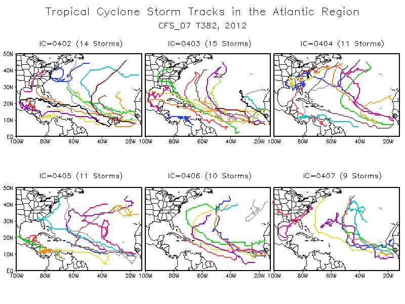
63 CFS-based TS, Hurricanes and ACE Index Forecast Atlantic Basin May forecast Tropical Storms Hurricanes ACE Index % of Median Slightly Above Normal Year Tropical Storms Hurricanes ACE Index % of Median Ensemble Standard Deviation Range Model Clim
64
65 Seasonal Forecast Caveats: 1) Even with perfect knowledge of all predictors only 50-60% of the variance in TC activity is explained. This could increase as dynamical model skill grows. 2) This make a 1-category forecast error possible in 1 out of 3 or 4 years, and a 2-category error in 1 in ~7 years. 3) In seasonal forecasting, you will be flat wrong some years despite your best efforts is a prime example.
66 Model Forecast Summary: 2013 Atlantic Outlook Model predicted ranges (± 1 σ) and mean activity (in parenthesis). The model averages (yellow) and NOAA s outlook (Red) are shown at bottom. Statistical CFS European Model CPC Regression: Named Storms Hurricanes Major Hurricanes ACE (% Median) (16) 7-9 (8) (3.75) (155) CPC Binning : Nino 3.4+SSTA (14.7) (7.85) (4) (143) CPC Binning ENSO+SSTA (15.55) (8.45) (4.35) (167) CFS: Hi-Res T (16.4) (8.2) (155) CFS-V2 T126: (14) 6-9 (7.5) 3-4 (3.5) (140) CFS-V2 T126: (15) 7-10 (8.5) 3-4 (3.5) (152) CFS-V2 T126: (15) 6-10 (8) 3-4 (3.5) (152) ECMWF: (12.6) (8) (128) EUROSIP: (11) Guidance Mean (14.5) (8.1) (3.8) (149) NOAA Outlook (16.5) 6-11 (8.5) 3-6 (4.5) (163) Actual:
67 NOAA Forecast Methodology 1) Assess states of the ocean and atmosphere. 2) Use model forecasts for El Niño/Atlantic SSTs and incorporate any analog techniques and dynamical model forecasts of TCs. 3) Predict range of overall activity and probabilities of above-, near-, and belowaverage seasons. 4) Qualitative/Quantitative process. 5) No forecast of hurricane landfalls, just the total seasonal activity for the entire basin.
68 Why issue a seasonal hurricane outlook then? One of the top questions NOAA gets in the offseason is What s the season going to be like? Large amount of media coverage makes it ideal to get the preparedness/awareness message out, even if most people can t use the forecast. Gets people thinking about the upcoming hurricane season/activity. Specialized users (reinsurance companies, offshore interests etc.)

 and August (Red) outlooks, large skill improvements are seen since 2008 for all predicted parameters except Season")
69 Percent Correct Forecasts (%) Percent of Correctly Forecasted Parameters Named May August Storms May Hurricanes August Major May Hurricanes August May ACE August season May strength August Outlooks Outlooks Outlooks Outlooks Outlooks Named Storms Hurricanes Major Hurricanes ACE Season Classification For both the May (Blue) and August (Red) outlooks, large skill improvements are seen since 2008 for all predicted parameters except Season Classification,. 17
70 Exercise Using what you have been taught about seasonal forecasting, make a seasonal forecast with the atmospheric and oceanic slides in the following slides. Please forecast ranges of activity for tropical storms, hurricanes, major hurricanes and ACE. Remember long term averages are 12 TS, 6 H, 3 MH and ACE ~ 100 What are the expected climate conditions for hurricane season? How will these conditions affect your forecast?

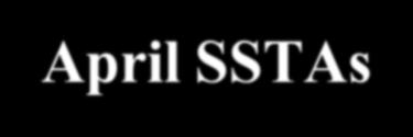
71 March-April SSTAs


72 April SST and SSTA

73 Tropical Pacific SSTA Evolution

74 Time-Longitude Section of 850-hPa Zonal Wind Anomalies averaged 5N-5S
75 ENSO Forecast Plume
76 Niño 3.4 region: CFS Forecast

77 T382 High Resolution SST anomaly forecast:

78 T382 High Resolution shear anomaly forecast:
79 Storm Counts and ACE Index Atlantic Basin CFS is predicting 7.5 storms versus a 10.9 storm climatology. ACE Index is only 75% of Normal
80
81
82 Updated CFS (T-62) ACE Forecast : ATLANTIC ICs Method 1 Method 2 Method 3 ACE Forecast 03/31 04/ /07 04/ /13 04/ Range 03/31 04/ (Forecast one standard deviation of inter-member spreads) 04/07 04/21 04/13 04/
83 Updated CFS (T-62) MH Forecast : ATLANTIC ICs Method 1 Method 2 Method 3 Major Hurricanes Forecast 03/31 04/ /07 04/ /13 04/ Range 03/31 04/ (Forecast one standard deviation of inter-member spreads) 04/07 04/21 04/13 04/
84 Updated CFS (T-62) Hurricane Forecast: ATLANTIC ICs Method 1 Method 2 Method 3 Hurricanes Forecast 03/31 04/ /07 04/21 04/13 04/ Range 03/31 04/ (Forecast one standard deviation of inter-member spreads) 04/07 04/21 04/13 04/
85 Updated CFS (T-62) NS Forecast: ATLANTIC ICs Method 1 Method 2 Method 3 Named Storms Forecast 03/31 04/ /07 04/ /13 04/ Range 03/31 04/ (Forecast one standard deviation of inter-member spreads) 04/07 04/21 04/13 04/

86 TS forecast from ECMWF
87 Hurricanes forecast from ECMWF
88 ACE forecast from ECMWF

89 ASO SLPA forecast from ECMWF

90 ASO SSTA forecast from ECMWF

91 Question 3 What ACE did you predict for the exercise? A. Under 60 B C D. Over 120
92 What about 2018?

93 Current Global SST anomalies

94 La Niña gradually weakening

95 Strong downwelling oceanic Kelvin Wave
96 CFS forecasts best chance of neutral for ASO 2018 El Nino Neutral La Nina
97 El Nino Neutral ECMWF warmer than CFS, neutral likely by Spring, El Nino possible by late summer La Nina
98 Nino models aren t very good though!

99 El Nino Neutral La Nina Huge uncertainty for summer!


100 CFS ASO Seasonal Forecasts from Feb 26 SST (warm Atlantic, neutral ENSO) Vertical Shear (lower than normal)

101 ECMWF JJA SST forecast Both CFS/EC agree on warm high latitude Atlantic, ENSO big unknown
102 Conclusions The MJO and Kelvin waves modulate TC activity around the globe. El Niño/La Niña conditions are probably the most important factor in a seasonal forecast. Tropical Atlantic Ocean water temperatures and multidecadal cycles are also very important. There are also year-to-year differences in vertical wind shear, sea-level pressures, and global circulation changes during the early part of the season that may give clues to how the rest of the season may turn out appears to be less active than 2017 but how much so is an open question.
Intraseasonal Variability and TC Forecasting
 Intraseasonal Variability and TC Forecasting 2017 WMO Class Eric Blake Hurricane Specialist National Hurricane Center 3/1/2017 Outline Madden-Julian Oscillation (MJO) MJO analysis tools Kelvin Waves Brief
The 2009 Hurricane Season Overview
 The 2009 Hurricane Season Overview Jae-Kyung Schemm Gerry Bell Climate Prediction Center NOAA/ NWS/ NCEP 1 Overview outline 1. Current status for the Atlantic, Eastern Pacific and Western Pacific basins
ENSO Cycle: Recent Evolution, Current Status and Predictions. Update prepared by Climate Prediction Center / NCEP 23 April 2012
 ENSO Cycle: Recent Evolution, Current Status and Predictions Update prepared by Climate Prediction Center / NCEP 23 April 2012 Outline Overview Recent Evolution and Current Conditions Oceanic Niño Index
ENSO Cycle: Recent Evolution, Current Status and Predictions. Update prepared by Climate Prediction Center / NCEP 5 August 2013
 ENSO Cycle: Recent Evolution, Current Status and Predictions Update prepared by Climate Prediction Center / NCEP 5 August 2013 Outline Overview Recent Evolution and Current Conditions Oceanic Niño Index
ENSO Cycle: Recent Evolution, Current Status and Predictions. Update prepared by Climate Prediction Center / NCEP 25 February 2013
 ENSO Cycle: Recent Evolution, Current Status and Predictions Update prepared by Climate Prediction Center / NCEP 25 February 2013 Outline Overview Recent Evolution and Current Conditions Oceanic Niño Index
ENSO: Recent Evolution, Current Status and Predictions. Update prepared by: Climate Prediction Center / NCEP 30 October 2017
 ENSO: Recent Evolution, Current Status and Predictions Update prepared by: Climate Prediction Center / NCEP 30 October 2017 Outline Summary Recent Evolution and Current Conditions Oceanic Niño Index (ONI)
ENSO Cycle: Recent Evolution, Current Status and Predictions. Update prepared by Climate Prediction Center / NCEP 11 November 2013
 ENSO Cycle: Recent Evolution, Current Status and Predictions Update prepared by Climate Prediction Center / NCEP 11 November 2013 Outline Overview Recent Evolution and Current Conditions Oceanic Niño Index
What is the Madden-Julian Oscillation (MJO)?
?") What is the Madden-Julian Oscillation (MJO)? Planetary scale, 30 90 day oscillation in zonal wind, precipitation, surface pressure, humidity, etc., that propagates slowly eastward Wavelength = 12,000 20,000
What is the Madden-Julian Oscillation (MJO)? Planetary scale, 30 90 day oscillation in zonal wind, precipitation, surface pressure, humidity, etc., that propagates slowly eastward Wavelength = 12,000 20,000
ENSO Cycle: Recent Evolution, Current Status and Predictions. Update prepared by Climate Prediction Center / NCEP July 26, 2004
 ENSO Cycle: Recent Evolution, Current Status and Predictions Update prepared by Climate Prediction Center / NCEP July 26, 2004 Outline Overview Recent Evolution and Current Conditions Oceanic NiZo Index
ENSO: Recent Evolution, Current Status and Predictions. Update prepared by: Climate Prediction Center / NCEP 9 November 2015
 ENSO: Recent Evolution, Current Status and Predictions Update prepared by: Climate Prediction Center / NCEP 9 November 2015 Outline Summary Recent Evolution and Current Conditions Oceanic Niño Index (ONI)
ENSO Cycle: Recent Evolution, Current Status and Predictions. Update prepared by Climate Prediction Center / NCEP 15 July 2013
 ENSO Cycle: Recent Evolution, Current Status and Predictions Update prepared by Climate Prediction Center / NCEP 15 July 2013 Outline Overview Recent Evolution and Current Conditions Oceanic Niño Index
ENSO Cycle: Recent Evolution, Current Status and Predictions. Update prepared by Climate Prediction Center / NCEP 24 September 2012
 ENSO Cycle: Recent Evolution, Current Status and Predictions Update prepared by Climate Prediction Center / NCEP 24 September 2012 Outline Overview Recent Evolution and Current Conditions Oceanic Niño
2011 Atlantic Hurricane Activity and Outlooks A Climate/ Historical Perspective
 2011 Atlantic Hurricane Activity and Outlooks A Climate/ Historical Perspective Gerry Bell NOAA Lead Seasonal Hurricane Forecaster Climate Prediction Center/ NWS Related Publications: Bell and Chelliah
Why the Atlantic was surprisingly quiet in 2013
 1 Why the Atlantic was surprisingly quiet in 2013 by William Gray and Phil Klotzbach Preliminary Draft - March 2014 (Final draft by early June) ABSTRACT This paper discusses the causes of the unusual dearth
COLORADO STATE UNIVERSITY FORECAST OF ATLANTIC HURRICANE ACTIVITY FROM SEPTEMBER 15 SEPTEMBER 28, 2015
 COLORADO STATE UNIVERSITY FORECAST OF ATLANTIC HURRICANE ACTIVITY FROM SEPTEMBER 15 SEPTEMBER 28, 2015 We expect that the next two weeks will be characterized by below-average amounts (
COLORADO STATE UNIVERSITY FORECAST OF ATLANTIC HURRICANE ACTIVITY FROM AUGUST 4-17, 2015
 COLORADO STATE UNIVERSITY FORECAST OF ATLANTIC HURRICANE ACTIVITY FROM AUGUST 4-17, 2015 We expect that the next two weeks will be characterized by below-average amounts (
COLORADO STATE UNIVERSITY FORECAST OF ATLANTIC HURRICANE ACTIVITY FROM AUGUST 18-31, 2017
 COLORADO STATE UNIVERSITY FORECAST OF ATLANTIC HURRICANE ACTIVITY FROM AUGUST 18-31, 2017 We expect that the next two weeks will be characterized by above-average amounts (>130%) of activity relative to
PRMS WHITE PAPER 2014 NORTH ATLANTIC HURRICANE SEASON OUTLOOK. June RMS Event Response
 PRMS WHITE PAPER 2014 NORTH ATLANTIC HURRICANE SEASON OUTLOOK June 2014 - RMS Event Response 2014 SEASON OUTLOOK The 2013 North Atlantic hurricane season saw the fewest hurricanes in the Atlantic Basin
COLORADO STATE UNIVERSITY FORECAST OF ATLANTIC HURRICANE ACTIVITY FROM AUGUST 16 29, 2018
 COLORADO STATE UNIVERSITY FORECAST OF ATLANTIC HURRICANE ACTIVITY FROM AUGUST 16 29, 2018 We expect that the next two weeks will be characterized by below-normal amounts of hurricane activity. (as of 16
2013 ATLANTIC HURRICANE SEASON OUTLOOK. June RMS Cat Response
 2013 ATLANTIC HURRICANE SEASON OUTLOOK June 2013 - RMS Cat Response Season Outlook At the start of the 2013 Atlantic hurricane season, which officially runs from June 1 to November 30, seasonal forecasts
COLORADO STATE UNIVERSITY FORECAST OF ATLANTIC HURRICANE ACTIVITY FROM AUGUST 2 AUGUST 15, 2013
 COLORADO STATE UNIVERSITY FORECAST OF ATLANTIC HURRICANE ACTIVITY FROM AUGUST 2 AUGUST 15, 2013 We expect that the next two weeks will be characterized by below-average amounts (
FORECAST OF ATLANTIC SEASONAL HURRICANE ACTIVITY AND LANDFALL STRIKE PROBABILITY FOR 2018
 FORECAST OF ATLANTIC SEASONAL HURRICANE ACTIVITY AND LANDFALL STRIKE PROBABILITY FOR 2018 We have decreased our forecast and now believe that 2018 will have below-average activity. The tropical and subtropical
NOAA 2015 Updated Atlantic Hurricane Season Outlook
 NOAA 2015 Updated Atlantic Hurricane Season Outlook Dr. Gerry Bell Lead Seasonal Forecaster Climate Prediction Center/ NOAA/ NWS Collaboration With National Hurricane Center/ NOAA/ NWS Hurricane Research
COLORADO STATE UNIVERSITY FORECAST OF ATLANTIC HURRICANE ACTIVITY FROM AUGUST 14 AUGUST 27, 2014
 COLORADO STATE UNIVERSITY FORECAST OF ATLANTIC HURRICANE ACTIVITY FROM AUGUST 14 AUGUST 27, 2014 We expect that the next two weeks will be characterized by below-average amounts (less than 70 percent)
ENSO Outlook by JMA. Hiroyuki Sugimoto. El Niño Monitoring and Prediction Group Climate Prediction Division Japan Meteorological Agency
 ENSO Outlook by JMA Hiroyuki Sugimoto El Niño Monitoring and Prediction Group Climate Prediction Division Outline 1. ENSO impacts on the climate 2. Current Conditions 3. Prediction by JMA/MRI-CGCM 4. Summary
COLORADO STATE UNIVERSITY FORECAST OF ATLANTIC HURRICANE ACTIVITY FROM SEPTEMBER 1 SEPTEMBER 14, 2015
 COLORADO STATE UNIVERSITY FORECAST OF ATLANTIC HURRICANE ACTIVITY FROM SEPTEMBER 1 SEPTEMBER 14, 2015 We expect that the next two weeks will be characterized by below-average amounts (
QUALITATIVE DISCUSSION OF ATLANTIC BASIN SEASONAL HURRICANE ACTIVITY FOR 2019
 QUALITATIVE DISCUSSION OF ATLANTIC BASIN SEASONAL HURRICANE ACTIVITY FOR 2019 We provide qualitative discussions of the factors which will determine next year s Atlantic basin hurricane activity with our
COLORADO STATE UNIVERSITY FORECAST OF ATLANTIC HURRICANE ACTIVITY FROM AUGUST 16 AUGUST 29, 2013
 COLORADO STATE UNIVERSITY FORECAST OF ATLANTIC HURRICANE ACTIVITY FROM AUGUST 16 AUGUST 29, 2013 We expect that the next two weeks will be characterized by above-average amounts (greater than 130 percent)
COLORADO STATE UNIVERSITY FORECAST OF ATLANTIC HURRICANE ACTIVITY FROM SEPTEMBER 28 OCTOBER 11, 2011
 COLORADO STATE UNIVERSITY FORECAST OF ATLANTIC HURRICANE ACTIVITY FROM SEPTEMBER 28 OCTOBER 11, 2011 We expect that the next two weeks will be characterized by below-average amounts (less than 70 percent)
Climate Forecast Applications Network (CFAN)
") Forecast of 2018 Atlantic Hurricane Activity April 5, 2018 Summary CFAN s inaugural April seasonal forecast for Atlantic tropical cyclone activity is based on systematic interactions among ENSO, stratospheric
Forecast of 2018 Atlantic Hurricane Activity April 5, 2018 Summary CFAN s inaugural April seasonal forecast for Atlantic tropical cyclone activity is based on systematic interactions among ENSO, stratospheric
FORECAST OF ATLANTIC SEASONAL HURRICANE ACTIVITY AND LANDFALL STRIKE PROBABILITY FOR 2015
 FORECAST OF ATLANTIC SEASONAL HURRICANE ACTIVITY AND LANDFALL STRIKE PROBABILITY FOR 2015 We continue to foresee a below-average 2015 Atlantic hurricane season. A moderate to strong El Niño is underway,
COLORADO STATE UNIVERSITY FORECAST OF ATLANTIC HURRICANE ACTIVITY FROM SEPTEMBER 27-OCTOBER 10, 2018
 COLORADO STATE UNIVERSITY FORECAST OF ATLANTIC HURRICANE ACTIVITY FROM SEPTEMBER 27-OCTOBER 10, 2018 We expect that the next two weeks will be characterized by above-normal amounts of hurricane activity,
COLORADO STATE UNIVERSITY FORECAST OF ATLANTIC HURRICANE ACTIVITY FROM SEPTEMBER 25 OCTOBER 8, 2014
 COLORADO STATE UNIVERSITY FORECAST OF ATLANTIC HURRICANE ACTIVITY FROM SEPTEMBER 25 OCTOBER 8, 2014 We expect that the next two weeks will be characterized by below-average amounts (
2016 Hurricane Season Preview
 2016 Hurricane Season Preview Eric Uhlhorn, Ph.D. 1 2 Recap of 2015 Hurricane Season - El Niño played a significant role in activity - Atlantic activity was slightly below normal 11 named storms, 4 hurricanes,
COLORADO STATE UNIVERSITY FORECAST OF ATLANTIC HURRICANE ACTIVITY FROM AUGUST 17 AUGUST 30, 2012
 COLORADO STATE UNIVERSITY FORECAST OF ATLANTIC HURRICANE ACTIVITY FROM AUGUST 17 AUGUST 30, 2012 We expect that the next two weeks will be characterized by above-average amounts (greater than 130 percent)
COLORADO STATE UNIVERSITY FORECAST OF ATLANTIC HURRICANE ACTIVITY FROM AUGUST 31 SEPTEMBER 13, 2012
 COLORADO STATE UNIVERSITY FORECAST OF ATLANTIC HURRICANE ACTIVITY FROM AUGUST 31 SEPTEMBER 13, 2012 We expect that the next two weeks will be characterized by average amounts (70-130 percent) of activity
Introduction of products for Climate System Monitoring
 Introduction of products for Climate System Monitoring 1 Typical flow of making one month forecast Textbook P.66 Observed data Atmospheric and Oceanic conditions Analysis Numerical model Ensemble forecast
Introduction of climate monitoring and analysis products for one-month forecast
 Introduction of climate monitoring and analysis products for one-month forecast TCC Training Seminar on One-month Forecast on 13 November 2018 10:30 11:00 1 Typical flow of making one-month forecast Observed
COLORADO STATE UNIVERSITY FORECAST OF ATLANTIC HURRICANE ACTIVITY FROM AUGUST 30 SEPTEMBER 12, 2013
 COLORADO STATE UNIVERSITY FORECAST OF ATLANTIC HURRICANE ACTIVITY FROM AUGUST 30 SEPTEMBER 12, 2013 We expect that the next two weeks will be characterized by average amounts (70-130 percent) of activity
COLORADO STATE UNIVERSITY FORECAST OF ATLANTIC HURRICANE ACTIVITY FROM SEPTEMBER 13-SEPTEMBER 26, 2018
 COLORADO STATE UNIVERSITY FORECAST OF ATLANTIC HURRICANE ACTIVITY FROM SEPTEMBER 13-SEPTEMBER 26, 2018 We expect that the next two weeks will be characterized by near-normal amounts of hurricane activity.
AnuMS 2018 Atlantic Hurricane Season Forecast
 AnuMS 2018 Atlantic Hurricane Season Forecast : June 11, 2018 by Dale C. S. Destin (follow @anumetservice) Director (Ag), Antigua and Barbuda Meteorological Service (ABMS) The *AnuMS (Antigua Met Service)
AnuMS 2018 Atlantic Hurricane Season Forecast
 AnuMS 2018 Atlantic Hurricane Season Forecast Issued: May 10, 2018 by Dale C. S. Destin (follow @anumetservice) Director (Ag), Antigua and Barbuda Meteorological Service (ABMS) The *AnuMS (Antigua Met
Seasonal Climate Outlook for South Asia (June to September) Issued in May 2014
 Issued in May 2014") Ministry of Earth Sciences Earth System Science Organization India Meteorological Department WMO Regional Climate Centre (Demonstration Phase) Pune, India Seasonal Climate Outlook for South Asia (June
Ministry of Earth Sciences Earth System Science Organization India Meteorological Department WMO Regional Climate Centre (Demonstration Phase) Pune, India Seasonal Climate Outlook for South Asia (June
El Niño Update Impacts on Florida
 Current Issues in Emergency Management (CIEM) Sessions 1 &2 October 12 th and 26 th, 2006 Florida Division of Emergency Management Tallahassee, Florida El Niño Update Impacts on Florida Bart Hagemeyer
The 2005 North Atlantic Hurricane Season A Climate Perspective
 The 2005 North Atlantic Hurricane Season A Climate Perspective Gerald Bell 1, Eric Blake 2, Chris Landsea 2, Kingtse Mo 1, Richard Pasch 2, Muthuvel Chelliah 1, Stanley Goldenberg 3 1 Climate Prediction
Global Ocean Monitoring: Recent Evolution, Current Status, and Predictions
 Global Ocean Monitoring: Recent Evolution, Current Status, and Predictions Prepared by Climate Prediction Center, NCEP November 6, 2009 http://www.cpc.ncep.noaa.gov/products/godas/ This project to deliver
Variability of West African Weather Systems. Chris Thorncroft Department of Atmospheric and Environmental Sciences University at Albany
 Variability of West African Weather Systems Chris Thorncroft Department of Atmospheric and Environmental Sciences University at Albany Variability of West African Weather Systems (1) Convectively Coupled
July Forecast Update for North Atlantic Hurricane Activity in 2018
 July Forecast Update for North Atlantic Hurricane Activity in 2018 Issued: 5 th July 2018 by Professor Mark Saunders and Dr Adam Lea Dept. of Space and Climate Physics, UCL (University College London),
Ocean-Atmosphere Interactions and El Niño Lisa Goddard
 Ocean-Atmosphere Interactions and El Niño Lisa Goddard Advanced Training Institute on Climatic Variability and Food Security 2002 July 9, 2002 Coupled Behavior in tropical Pacific SST Winds Upper Ocean
El Niño-Southern Oscillation, the Madden-Julian Oscillation and Atlantic basin tropical cyclone rapid intensification
 JOURNAL OF GEOPHYSICAL RESEARCH, VOL. 117,, doi:10.1029/2012jd017714, 2012 El Niño-Southern Oscillation, the Madden-Julian Oscillation and Atlantic basin tropical cyclone rapid intensification Philip J.
COLORADO STATE UNIVERSITY FORECAST OF ATLANTIC HURRICANE ACTIVITY FROM OCTOBER 13 OCTOBER 26, 2017
 COLORADO STATE UNIVERSITY FORECAST OF ATLANTIC HURRICANE ACTIVITY FROM OCTOBER 13 OCTOBER 26, 2017 We expect that the next two weeks will be characterized by above-normal hurricane activity. (as of 13
IASCLiP FORECAST FORUM (IFF)
") IASCLiP FORECAST FORUM (IFF) August-September-October 2012 Disclaimer: The forecast and the discussions in this forum in no way reflect the opinion of the contributing personnel s institutions and organizations.
IASCLiP FORECAST FORUM (IFF) August-September-October 2012 Disclaimer: The forecast and the discussions in this forum in no way reflect the opinion of the contributing personnel s institutions and organizations.
An upper to mid level circulation (Low) in the NW Caribbean is
 in the NW Caribbean is") WEEKLY WEATHER OUTLOOK BELIZE, CENTRAL AMERICA PERIOD: Monday-Monday, Oct. 1 October 8, 2012 DATE ISSUED: Monday, Oct 1, 2012 6:00 am RFrutos EcoSolutions & Services SYNOPSIS: An upper to mid level circulation
WEEKLY WEATHER OUTLOOK BELIZE, CENTRAL AMERICA PERIOD: Monday-Monday, Oct. 1 October 8, 2012 DATE ISSUED: Monday, Oct 1, 2012 6:00 am RFrutos EcoSolutions & Services SYNOPSIS: An upper to mid level circulation
Pre-Season Forecast for North Atlantic Hurricane Activity in 2018
 Pre-Season Forecast for North Atlantic Hurricane Activity in 2018 Issued: 30 th May 2018 by Professor Mark Saunders and Dr Adam Lea Dept. of Space and Climate Physics, UCL (University College London),
August Forecast Update for Atlantic Hurricane Activity in 2015
 August Forecast Update for Atlantic Hurricane Activity in 2015 Issued: 5 th August 2015 by Professor Mark Saunders and Dr Adam Lea Dept. of Space and Climate Physics, UCL (University College London), UK
AnuMS 2018 Atlantic Hurricane Season Forecast
 AnuMS 2018 Atlantic Hurricane Season : August 12, 2018 by Dale C. S. Destin (follow @anumetservice) Director (Ag), Antigua and Barbuda Meteorological Service (ABMS) The *AnuMS (Antigua Met Service) is
July Forecast Update for Atlantic Hurricane Activity in 2017
 July Forecast Update for Atlantic Hurricane Activity in 2017 Issued: 4 th July 2017 by Professor Mark Saunders and Dr Adam Lea Dept. of Space and Climate Physics, UCL (University College London), UK Forecast
AnuMS 2018 Atlantic Hurricane Season Forecast
 AnuMS 2018 Atlantic Hurricane Season Forecast Issued: April 10, 2018 by Dale C. S. Destin (follow @anumetservice) Director (Ag), Antigua and Barbuda Meteorological Service (ABMS) The *AnuMS (Antigua Met
Topic 3.2: Tropical Cyclone Variability on Seasonal Time Scales (Observations and Forecasting)
") Topic 3.2: Tropical Cyclone Variability on Seasonal Time Scales (Observations and Forecasting) Phil Klotzbach 7 th International Workshop on Tropical Cyclones November 18, 2010 Working Group: Maritza Ballester
Topic 3.2: Tropical Cyclone Variability on Seasonal Time Scales (Observations and Forecasting) Phil Klotzbach 7 th International Workshop on Tropical Cyclones November 18, 2010 Working Group: Maritza Ballester
April Forecast Update for Atlantic Hurricane Activity in 2016
 April Forecast Update for Atlantic Hurricane Activity in 2016 Issued: 5 th April 2016 by Professor Mark Saunders and Dr Adam Lea Dept. of Space and Climate Physics, UCL (University College London), UK
1. Introduction. 2. Verification of the 2010 forecasts. Research Brief 2011/ February 2011
 Research Brief 2011/01 Verification of Forecasts of Tropical Cyclone Activity over the Western North Pacific and Number of Tropical Cyclones Making Landfall in South China and the Korea and Japan region
Wind: Global Systems Chapter 10
 Wind: Global Systems Chapter 10 General Circulation of the Atmosphere General circulation of the atmosphere describes average wind patterns and is useful for understanding climate Over the earth, incoming
UPDATE OF REGIONAL WEATHER AND SMOKE HAZE (December 2017)
") UPDATE OF REGIONAL WEATHER AND SMOKE HAZE (December 2017) 1. Review of Regional Weather Conditions for November 2017 1.1 In November 2017, Southeast Asia experienced inter-monsoon conditions in the first
UPDATE OF REGIONAL WEATHER AND SMOKE HAZE (December 2017) 1. Review of Regional Weather Conditions for November 2017 1.1 In November 2017, Southeast Asia experienced inter-monsoon conditions in the first
Behind the Climate Prediction Center s Extended and Long Range Outlooks Mike Halpert, Deputy Director Climate Prediction Center / NCEP
 Behind the Climate Prediction Center s Extended and Long Range Outlooks Mike Halpert, Deputy Director Climate Prediction Center / NCEP September 2012 Outline Mission Extended Range Outlooks (6-10/8-14)
Chapter 4. Understanding the Weather. Weather is short-term and caused by various air and ocean circulations
 Video: Meteorologist Paul Douglas April 2013 Understanding the Weather Weather is short-term and caused by various air and ocean circulations There are natural climate cycle that cause large climate changes
Lecture 8: Natural Climate Variability
 Lecture 8: Natural Climate Variability Extratropics: PNA, NAO, AM (aka. AO), SAM Tropics: MJO Coupled A-O Variability: ENSO Decadal Variability: PDO, AMO Unforced vs. Forced Variability We often distinguish
July Forecast Update for Atlantic Hurricane Activity in 2016
 July Forecast Update for Atlantic Hurricane Activity in 2016 Issued: 5 th July 2016 by Professor Mark Saunders and Dr Adam Lea Dept. of Space and Climate Physics, UCL (University College London), UK Forecast
The Association between Intraseasonal Oscillations and Tropical Storms in the Atlantic Basin
 4097 The Association between Intraseasonal Oscillations and Tropical Storms in the Atlantic Basin KINGTSE C. MO Climate Prediction Center, NCEP/NWS/NOAA, Camp Springs, Maryland (Manuscript received 4 October
The 2014 Atlantic Hurricane Season. What is New and What to Expect. Mark Chambers President & CEO ImpactWeather, Inc.
 The 2014 Atlantic Hurricane Season What is New and What to Expect Mark Chambers President & CEO ImpactWeather, Inc. Hurricane Climatology for the Gulf of Mexico A Look back at 2013 The outlook for this
Atmospheric circulation analysis for seasonal forecasting
 Training Seminar on Application of Seasonal Forecast GPV Data to Seasonal Forecast Products 18 21 January 2011 Tokyo, Japan Atmospheric circulation analysis for seasonal forecasting Shotaro Tanaka Climate
EXTENDED RANGE FORECAST OF ATLANTIC SEASONAL HURRICANE ACTIVITY AND LANDFALL STRIKE PROBABILITY FOR (as of 5 April 2018)
") EXTENDED RANGE FORECAST OF ATLANTIC SEASONAL HURRICANE ACTIVITY AND LANDFALL STRIKE PROBABILITY FOR 2018 We anticipate that the 2018 Atlantic basin hurricane season will have slightly aboveaverage activity.
EXTENDED RANGE FORECAST OF ATLANTIC SEASONAL HURRICANE ACTIVITY AND LANDFALL STRIKE PROBABILITY FOR 2018 We anticipate that the 2018 Atlantic basin hurricane season will have slightly aboveaverage activity.
Weather Outlook for Spring and Summer in Central TX. Aaron Treadway Meteorologist National Weather Service Austin/San Antonio
 Weather Outlook for Spring and Summer in Central TX Aaron Treadway Meteorologist National Weather Service Austin/San Antonio Outline A Look Back At 2014 Spring 2015 So Far El Niño Update Climate Prediction
August Forecast Update for Atlantic Hurricane Activity in 2016
 August Forecast Update for Atlantic Hurricane Activity in 2016 Issued: 5 th August 2016 by Professor Mark Saunders and Dr Adam Lea Dept. of Space and Climate Physics, UCL (University College London), UK
Issued by the: Climate Services Division Fiji Meteorological Service Nadi Airport. 27 October 2010 GENERAL STATEMENT
 Fiji Meteorological Service (FMS) Tropical Cyclone Guidance for Season 2010/11 for the Fiji and the Southwest Pacific RSMC Region 160E to 120W Equator to 25 South Issued by the: Climate Services Division
Charles Jones ICESS University of California, Santa Barbara CA Outline
 The Influence of Tropical Variations on Wintertime Precipitation in California: Pineapple express, Extreme rainfall Events and Long-range Statistical Forecasts Charles Jones ICESS University of California,
Agricultural Outlook Forum Presented: February 17, 2006 THE SCIENCE BEHIND THE ATLANTIC HURRICANES AND SEASONAL PREDICTIONS
 Agricultural Outlook Forum Presented: February 17, 2006 THE SCIENCE BEHIND THE ATLANTIC HURRICANES AND SEASONAL PREDICTIONS Gerald Bell Meteorologist, National Centers for Environmental Prediction NOAA,
The feature of atmospheric circulation in the extremely warm winter 2006/2007
 The feature of atmospheric circulation in the extremely warm winter 2006/2007 Hiroshi Hasegawa 1, Yayoi Harada 1, Hiroshi Nakamigawa 1, Atsushi Goto 1 1 Climate Prediction Division, Japan Meteorological
El Niño, South American Monsoon, and Atlantic Niño links as detected by a. TOPEX/Jason Observations
 El Niño, South American Monsoon, and Atlantic Niño links as detected by a decade of QuikSCAT, TRMM and TOPEX/Jason Observations Rong Fu 1, Lei Huang 1, Hui Wang 2, Paola Arias 1 1 Jackson School of Geosciences,
Climate Outlook through 2100 South Florida Ecological Services Office Vero Beach, FL September 9, 2014
 Climate Outlook through 2100 South Florida Ecological Services Office Vero Beach, FL September 9, 2014 Short Term Drought Map: Short-term (
Hurricanes. April 14, 2009
 Tropical Weather & Hurricanes Chapter 15 April 14, 2009 Tropical meteorology Tropics characterized by seasonal wet and drier periods- wet when sun is nearly overhead at noon and inter-tropical convergence
UPDATE OF REGIONAL WEATHER AND SMOKE HAZE (May 2017)
") UPDATE OF REGIONAL WEATHER AND SMOKE HAZE (May 2017) 1. Review of Regional Weather Conditions in April 2017 1.1 Inter monsoon conditions, characterised by afternoon showers and winds that are generally
UPDATE OF REGIONAL WEATHER AND SMOKE HAZE (May 2017) 1. Review of Regional Weather Conditions in April 2017 1.1 Inter monsoon conditions, characterised by afternoon showers and winds that are generally
The Madden Julian Oscillation in the ECMWF monthly forecasting system
 The Madden Julian Oscillation in the ECMWF monthly forecasting system Frédéric Vitart ECMWF, Shinfield Park, Reading RG2 9AX, United Kingdom F.Vitart@ecmwf.int ABSTRACT A monthly forecasting system has
April Forecast Update for North Atlantic Hurricane Activity in 2019
 April Forecast Update for North Atlantic Hurricane Activity in 2019 Issued: 5 th April 2019 by Professor Mark Saunders and Dr Adam Lea Dept. of Space and Climate Physics, UCL (University College London),
KUALA LUMPUR MONSOON ACTIVITY CENT
 T KUALA LUMPUR MONSOON ACTIVITY CENT 2 ALAYSIAN METEOROLOGICAL http://www.met.gov.my DEPARTMENT MINISTRY OF SCIENCE. TECHNOLOGY AND INNOVATIO Introduction Atmospheric and oceanic conditions over the tropical
Predictability and prediction of the North Atlantic Oscillation
 Predictability and prediction of the North Atlantic Oscillation Hai Lin Meteorological Research Division, Environment Canada Acknowledgements: Gilbert Brunet, Jacques Derome ECMWF Seminar 2010 September
EL NIÑO/SOUTHERN OSCILLATION (ENSO) DIAGNOSTIC DISCUSSION
 DIAGNOSTIC DISCUSSION") EL NIÑO/SOUTHERN OSCILLATION (ENSO) DIAGNOSTIC DISCUSSION issued by CLIMATE PREDICTION CENTER/NCEP/NWS and the International Research Institute for Climate and Society 11 October 2018 ENSO Alert System
EL NIÑO/SOUTHERN OSCILLATION (ENSO) DIAGNOSTIC DISCUSSION issued by CLIMATE PREDICTION CENTER/NCEP/NWS and the International Research Institute for Climate and Society 11 October 2018 ENSO Alert System
Primary Factors Contributing to Japan's Extremely Hot Summer of 2010
 temperature anomalies by its standard deviation for JJA 2010 Primary Factors Contributing to Japan's Extremely Hot Summer of 2010 Nobuyuki Kayaba Climate Prediction Division,Japan Meteorological Agancy
The Planetary Circulation System
 12 The Planetary Circulation System Learning Goals After studying this chapter, students should be able to: 1. describe and account for the global patterns of pressure, wind patterns and ocean currents
April Forecast Update for Atlantic Hurricane Activity in 2018
 April Forecast Update for Atlantic Hurricane Activity in 2018 Issued: 5 th April 2018 by Professor Mark Saunders and Dr Adam Lea Dept. of Space and Climate Physics, UCL (University College London), UK
GPC Exeter forecast for winter Crown copyright Met Office
 GPC Exeter forecast for winter 2015-2016 Global Seasonal Forecast System version 5 (GloSea5) ensemble prediction system the source for Met Office monthly and seasonal forecasts uses a coupled model (atmosphere
Forced and internal variability of tropical cyclone track density in the western North Pacific
 Forced and internal variability of tropical cyclone track density in the western North Pacific Wei Mei 1 Shang-Ping Xie 1, Ming Zhao 2 & Yuqing Wang 3 Climate Variability and Change and Paleoclimate Working
Colorado State University (CSU) Atlantic Hurricane Season Forecast
 Atlantic Hurricane Season Forecast") Colorado State University (CSU) Atlantic Hurricane Season Forecast Dr. Philip Klotzbach of Colorado State University (CSU) has issued his April forecast for the 2018 Atlantic Hurricane Season. The forecast
Colorado State University (CSU) Atlantic Hurricane Season Forecast Dr. Philip Klotzbach of Colorado State University (CSU) has issued his April forecast for the 2018 Atlantic Hurricane Season. The forecast
North Pacific Climate Overview N. Bond (UW/JISAO), J. Overland (NOAA/PMEL) Contact: Last updated: August 2009
, J. Overland (NOAA/PMEL) Contact: Last updated: August 2009") North Pacific Climate Overview N. Bond (UW/JISAO), J. Overland (NOAA/PMEL) Contact: Nicholas.Bond@noaa.gov Last updated: August 2009 Summary. The North Pacific atmosphere-ocean system from fall 2008 through
North Pacific Climate Overview N. Bond (UW/JISAO), J. Overland (NOAA/PMEL) Contact: Nicholas.Bond@noaa.gov Last updated: August 2009 Summary. The North Pacific atmosphere-ocean system from fall 2008 through
Global Climate Patterns and Their Impacts on North American Weather
 Global Climate Patterns and Their Impacts on North American Weather By Julie Malmberg and Jessica Lowrey, Western Water Assessment Introduction This article provides a broad overview of various climate
Hurricane Risk: Importance of Climate Time Scale and Uncertainty
 Hurricane Risk: Importance of Climate Time Scale and Uncertainty FCHLPM Workshop Peter S. Dailey, Ph.D. July 23-24, 2009 2009 AIR WORLDWIDE CORPORATION 1 Agenda Importance of Understanding Climate Change,
TROPICAL CYCLONE GENESIS. Todd B. Kimberlain and Richard J. Pasch WMO RA-IV Workshop on Hurricane Forecasting & Warning 7 March 2016
 TROPICAL CYCLONE GENESIS Todd B. Kimberlain and Richard J. Pasch WMO RA-IV Workshop on Hurricane Forecasting & Warning 7 March 2016 Outline / Topics Climatology Large-scale conditions associated with tropical
Topic 5.2: Seasonal Forecasts
 Topic 5.2: Seasonal Forecasts Contributions from: Maritza Ballester, Eric Blake, Suzanna Camargo, Joanne Camp, Johnny Chan, Phil Klotzbach, Yuriy Kuleshov, Mark Saunders, O. P. Singh, Gabriel Vecchi and
Observational Study of Subtropical Highs. Richard Grotjahn Dept. of Land, Air, and Water Resources University of California, Davis, U.S.A.
 Observational Study of Subtropical Highs Richard Grotjahn Dept. of Land, Air, and Water Resources University of California, Davis, U.S.A. Organization of Talk There are 5 subtropical highs Question: What
August Forecast Update for Atlantic Hurricane Activity in 2012
 August Forecast Update for Atlantic Hurricane Activity in 2012 Issued: 6 th August 2012 by Professor Mark Saunders and Dr Adam Lea Dept. of Space and Climate Physics, UCL (University College London), UK
CHAPTER 9 ATMOSPHERE S PLANETARY CIRCULATION MULTIPLE CHOICE QUESTIONS
 CHAPTER 9 ATMOSPHERE S PLANETARY CIRCULATION MULTIPLE CHOICE QUESTIONS 1. Viewed from above in the Northern Hemisphere, surface winds about a subtropical high blow a. clockwise and inward. b. counterclockwise.