N ew York State Agricultural Experiment S tation vnrfx* NYSAES I Publications I Latest Press Releases
|
|
|
- Frank O’Connor’
- 5 years ago
- Views:
Transcription


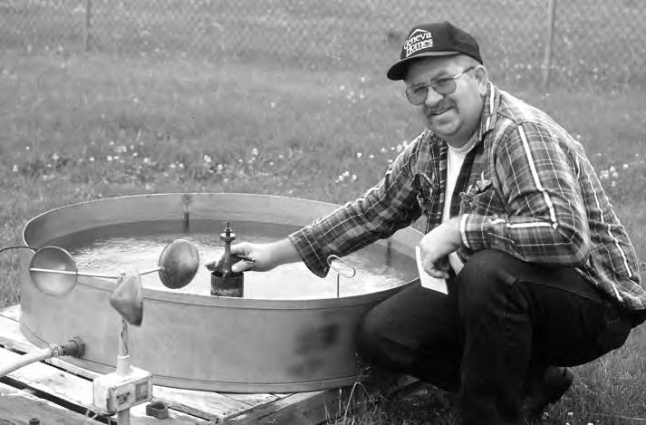
1 N ew York State Agricultural Experiment S tation vnrfx* NYSAES I Publications I Latest Press Releases CORNELL U N I V E R S I T Y GENEVA NEW YORK. 100 Years of New York Weather August 16th, 2000 CONTACT: Linda McCandless, llm3@cornell.edu, by Peter Seem GENEVA, NY: Monitoring the weather is a critical activity at the New York State Agricultural Experiment Station in Geneva, NY. The weather station there measured 4.12 inches of rain for the first two days of August, which sounds like a lot, for instance, but records show it doesn t begin to match the record two-day accumulation of 5.05 inches that fell on August 23 and 24 in "We have been logging daily maximum and minimum temperatures and precipitation for over 100 years," said Robert Seem, the plant pathologist who manages the weather station. Temperature and precipitation are important factors in the growth patterns of crops and the development and life cycles of pests. Surface wetness is an important measure for studying the conditions under which diseases flourish."the data is used mostly by the research community, but it also serves as a climate record for the region," said Seem. "Researchers use weather records so they know the conditions under which their experiments were conducted." Data collected and stored in the Geneva database is also available for public inquiry as a service to the community, said Seem. "We get requests from lawyers, insurance companies, Suggested caption: Steve Gordner takes a measurement from the evaporation pan, one of the last readings still taken manually at the weather station at the Fruit and Vegetable Farm. CREDIT: K. Stevens/NYSAES/Cornell Download 300 DPI jpg photo


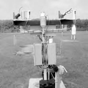
2 state police, and the attorney general s office." When sudden, heavy winds knocked over steel girders during the 1998 construction of the Guardian Glass factory, for instance, a worker was killed. At the trial, the court requested wind speed records and the Experiment Station provided them. The data is sent to the Northeast Regional Climate Center at Cornell University, the National Weather Service, the Natural Climate Data Center, the Natural Resource Conservation Service, and the Natural Resource Ecology Lab. SOME DATA IS STILL COLLECTED BY HAND The Experiment Station s weather station sits in a small fenced area atop a hill on the Fruit and Vegetable Research Farm off County Road #4. Additional equipment has been added since Now devices measure wind speed, evaporation, water temperature, soil temperature from 2 to 12 inches deep, soil moisture, solar radiation, surface wetness, relative humidity, and ultraviolet B radiation. Each morning, Steve Gordner or Lee Hibbard, from the Station s Field Research Unit, visits the weather station to record precipitation, evaporation, and daily high and low temperatures. All of the other measurements are recorded daily, hourly, or every 15 minutes, then logged and stored in a database. Daily summary data is compiled and entered into the database and provided to the public over the Internet, along with over 100 years of archives at After taking the readings, Hibbard calls a computer run by the National Weather Service (NWS) to dial in the previous day s information. The data also goes to the Northeast Regional Climate Center at Cornell and the National Climate Data Center s database. The Natural Resource Conservation Service has installed soil monitoring equipment at the Geneva site. Soil readings and the rest of the data, are integrated into the Soil Climate Analysis Network and made available for the scientific community at "The data have a wide variety of users... agriculture, the Federal Emergency Management Agency, engineering, researches, and global climate change to name a few," said Garry Schaefer, a hydrologist in Portland, Oregon, who leads the Hydromet Data Acquisition and Technology team of the National Water and Climate Center. AND THEN THERE S ULTRAVIOLET B Suggested caption: This UV-B monitoring station, installed at Geneva by Colorado State University, is one of 28 sites in North America that submit data to the UV-B network. CREDIT: P. Seem/NYSAES/Cornell Download 300 DPI jpg photo The Geneva site is also used by scientists at the USDA UV-B Radiation Monitoring Program


3 operated by the National Resource Ecology Laboratory at Colorado State University. Geneva is part of a network of 26 sites in the U.S. and two in Canada where Colorado State has installed a monitoring station for ultraviolet B, the mid-level energy form of UV radiation, nm. Geneva s UV-B equipment is connected to a phone line that transmits data to the headquarters in Fort Collins each night. "The Department of Agriculture wants to have a ground-based set of data for ultraviolet radiation. NASA satellites measure the ozone and predict ultraviolet radiation; we are a ground truth test for those measurements," said Bill Durham, manager of the UV-B Monitoring Network who installed the equipment at the initial sites, including Geneva, in Ultraviolet B, which is expected to increase as a result of the depletion of the ozone, affects the metabolism, photosynthesis and gene activity of plants. There hasn t been enough research to put the data to immediate use for growers, but the UV-B program is trying to create a basis for such work. "We re in the beginning stages of research. The information we gather can be used in conjunction with experiments to test UV-B s effects on plants. It s new research and we feel the data is of high quality," said James Slusser, director of the UV-B monitoring program. All of the radiation data is available for free, broken down by site, at Weather at the Station? Small talk? Hardly. NYSAES I Publications I Latest Contact Webmaster: webmaster@nysaes.comell.edu
4
5
AgWeatherNet A Tool for Making Decisions Based on Weather
 AgWeatherNet A Tool for Making Decisions Based on Weather Gerrit Hoogenboom Director, AgWeatherNet & Professor of Agrometeorology Washington State University Prosser, Washington November 14, 2013 Washington
Founding of a Grower-based Weather/Pest Information Network to Aid IPM Adoption
 Founding of a Grower-based Weather/Pest Information Network to Aid IPM Adoption December, 1996 Final Report Agricultural Telecommunications Project No. 95-EATP-1-0065 Project Coordinator: Curtis Petzoldt,
The Kentucky Mesonet: Entering a New Phase
 The Kentucky Mesonet: Entering a New Phase Stuart A. Foster State Climatologist Kentucky Climate Center Western Kentucky University KCJEA Winter Conference Lexington, Kentucky February 9, 2017 Kentucky
Climates of NYS. Definitions. Climate Regions of NYS. Storm Tracks. Climate Controls 10/13/2011. Characteristics of NYS s Climates
 Definitions Climates of NYS Prof. Anthony Grande 2011 Weather and Climate Weather the state of the atmosphere at one point in time. The elements of weather are temperature, air pressure, wind and moisture.
CoCoRaHS. Community Collaborative Rain, Hail, & Snow Network. Ashley Wolf Meteorologist NWS Green Bay Northeast Wisconsin CoCoRaHS Coordinator
 CoCoRaHS Community Collaborative Rain, Hail, & Snow Network Ashley Wolf Meteorologist NWS Green Bay Northeast Wisconsin CoCoRaHS Coordinator What is CoCoRaHS Who, What, Where and Whys of CoCoRaHS What?
The TexasET Network and Website User s Manual
 The TexasET Network and Website http://texaset.tamu.edu User s Manual By Charles Swanson and Guy Fipps 1 September 2013 Texas AgriLIFE Extension Service Texas A&M System 1 Extension Program Specialist;
MxVision WeatherSentry Web Services Content Guide
 MxVision WeatherSentry Web Services Content Guide July 2014 DTN 11400 Rupp Drive Minneapolis, MN 55337 00.1.952.890.0609 This document and the software it describes are copyrighted with all rights reserved.
The Colorado Agricultural no Meteorological Network (CoAgMet) and Crop ET Reports
 and Crop ET Reports") C R O P S E R I E S Irrigation Quick Facts The Colorado Agricultural no. 4.723 Meteorological Network (CoAgMet) and Crop ET Reports A.A. Andales, T. A. Bauder and N. J. Doesken 1 (10/09) CoAgMet is a network
C R O P S E R I E S Irrigation Quick Facts The Colorado Agricultural no. 4.723 Meteorological Network (CoAgMet) and Crop ET Reports A.A. Andales, T. A. Bauder and N. J. Doesken 1 (10/09) CoAgMet is a network
CIMIS. California Irrigation Management Information System
 CIMIS California Irrigation Management Information System What is CIMIS? A network of over 130 fully automated weather stations that collect weather data throughout California and provide estimates of
Applications/Users for Improved S2S Forecasts
 Applications/Users for Improved S2S Forecasts Nolan Doesken Colorado Climate Center Colorado State University WSWC Precipitation Forecasting Workshop June 7-9, 2016 San Diego, CA First -- A short background
Definitions Weather and Climate Climates of NYS Weather Climate 2012 Characteristics of Climate Regions of NYS NYS s Climates 1.
 Definitions Climates of NYS Prof. Anthony Grande 2012 Weather and Climate Weather the state of the atmosphere at one point in time. The elements of weather are temperature, t air pressure, wind and moisture.
Impact on Agriculture
 Weather Variability and the Impact on Agriculture InfoAg 2017 Copyright 2017, awhere. All Rights Reserved The Problem: The Earth s Atmosphere is a Heat Engine In transition 1 C warming of atmosphere Triples
The Colorado Climate Center at CSU. residents of the state through its threefold
 The CoAgMet Network: Overview History and How It Overview, Works N l Doesken Nolan D k and d Wendy W d Ryan R Colorado Climate Center Colorado State University First -- A short background In 1973 the federal
NJ Community Collaborative Rain, Hail and Snow Network
 NJ Community Collaborative Rain, Hail and Snow Network Mathieu Gerbush NJ Assistant State Climatologist/Climate Services Co-CoCoRaHS Coordinator NJ Agricultural Experiment Station School of Environmental
National Weather Service Greenville-Spartanburg, Forecast Office
 National Weather Service Greenville-Spartanburg, Forecast Office CoCoRaHS Presentation: NC CERT Conference May, 2017 Introduction- who we are. Federal Agency Within the U.S. Dept. of Commerce Introduction-
1 Introduction. Station Type No. Synoptic/GTS 17 Principal 172 Ordinary 546 Precipitation
 Use of Automatic Weather Stations in Ethiopia Dula Shanko National Meteorological Agency(NMA), Addis Ababa, Ethiopia Phone: +251116639662, Mob +251911208024 Fax +251116625292, Email: Du_shanko@yahoo.com
A Century of Meteorological Observations at Fort Valley Experimental Forest: A Cooperative Observer Program Success Story
 A Century of Meteorological Observations at Fort Valley Experimental Forest: A Cooperative Observer Program Success Story Daniel P. Huebner and Susan D. Olberding, U.S. Forest Service, Rocky Mountain Research
Weather versus Climate: What is the difference? Sources of Weather Information
 Joel O. Paz, Extension Agrometerologist and Gerrit Hoogenboom, Professor & REI Coordinator Department of Biological and Agricultural Engineering Weather versus Climate: What is the difference? The difference
CoCoRaHS Monitoring Colorado s s Water Resources through Community Collaborations
 CoCoRaHS Monitoring Colorado s s Water Resources through Community Collaborations Nolan Doesken Colorado Climate Center Atmospheric Science Department Colorado State University Presented at Sustaining
WHEN CAN YOU SEED FALLOW GROUND IN THE FALL? AN HISTORICAL PERSPECTIVE ON FALL RAIN
 WHEN CAN YOU SEED FALLOW GROUND IN THE FALL? AN HISTORICAL PERSPECTIVE ON FALL RAIN Steve Petrie and Karl Rhinhart Abstract Seeding at the optimum time is one key to producing the greatest yield of any
AT LAST, A USE FOR COMPUTERS: WEATHER FORECASTS AT THE BED LEVEL
 46 AT LAST, A USE FOR COMPUTERS: WEATHER FORECASTS AT THE BED LEVEL Bill Bland Extension Agricultural Climatologist Department of Soil Science, Univ. Wisconsin-Madison Computer-based communications are
Local Precipitation Variability
 Local Precipitation Variability Precipitation from one storm can vary from neighborhood to neighborhood. What falls in your yard may not fall in the next. The next time it rains see how the precipitation
Accessing and Using National Long Term Ecological Research (LTER) Climate and Hydrology Data from ClimDB and HydroDB: A Tutorial
 Climate and Hydrology Data from ClimDB and HydroDB: A Tutorial") Accessing and Using National Long Term Ecological Research (LTER) Climate and Hydrology Data from ClimDB and HydroDB: A Tutorial Gordon M. Heisler USDA Forest Service, Syracuse, NY Gary Fisher U.S. Geological
Accessing and Using National Long Term Ecological Research (LTER) Climate and Hydrology Data from ClimDB and HydroDB: A Tutorial Gordon M. Heisler USDA Forest Service, Syracuse, NY Gary Fisher U.S. Geological
NIDIS Intermountain West Drought Early Warning System August 8, 2017
 NIDIS Drought and Water Assessment 8/8/17, 4:43 PM NIDIS Intermountain West Drought Early Warning System August 8, 2017 Precipitation The images above use daily precipitation statistics from NWS COOP,
Fusarium Head Blight (FHB)
") Fusarium Head Blight (FHB) FHB is a Fungal disease of cereal crops that affects kernel development 1999 declared a pest under the Agricultural Pest Act 2002 Alberta released Fusarium Risk Management Plan
Fusarium Head Blight (FHB) FHB is a Fungal disease of cereal crops that affects kernel development 1999 declared a pest under the Agricultural Pest Act 2002 Alberta released Fusarium Risk Management Plan
The MRCC and Monitoring Drought in the Midwest
 The and Monitoring Drought in the Midwest Steve Hilberg Director, Illinois State Water Survey Prairie Research Institute, University of Illinois The A partner of a national climate service program that
North Carolina Climate Variations
 North Carolina Climate Variations Sethu Raman Professor of Atmospheric and Marine Sciences and State Climatologist State Climate Office of North Carolina North Carolina State University Latest Drought
Regional Flash Flood Guidance and Early Warning System
 WMO Training for Trainers Workshop on Integrated approach to flash flood and flood risk management 24-28 October 2010 Kathmandu, Nepal Regional Flash Flood Guidance and Early Warning System Dr. W. E. Grabs
Monitoring Extreme Weather Events. February 8, 2010
 Monitoring Extreme Weather Events February 8, 2010 Extensive network of over 800 stations across the Prairies Good coverage across entire agriculture production region Network of networks strategy includes
NIDIS Intermountain West Drought Early Warning System October 17, 2017
 NIDIS Drought and Water Assessment NIDIS Intermountain West Drought Early Warning System October 17, 2017 Precipitation The images above use daily precipitation statistics from NWS COOP, CoCoRaHS, and
Stand-Alone Systems that Measure, Record, and Display Weather Data - and Often More
 Page 1 of 5 Marne Coggan is a vineyard technology consultant, a software entineer and a Sonoma County vineyard owner. You can email him at marne@svn.net Stand-Alone Systems that Measure, Record, and Display
Satellites, Weather and Climate Module 40: Agriculture & forestry in a changing climate
 Satellites, Weather and Climate Module 40: Agriculture & forestry in a changing climate http://www.youtube.com/watch?v=ksnblyhrru8 http://1.bp.blogspot.com/-lemica8b_h4/ufln63qlxdi/aaaaaaaacym/xc3htckubeg/s1600/animated.gif
Communicating uncertainty from short-term to seasonal forecasting
 Communicating uncertainty from short-term to seasonal forecasting MAYBE NO YES Jay Trobec KELO-TV Sioux Falls, South Dakota USA TV weather in the US Most TV weather presenters have university degrees and
BSYSE 456/556 Surface Hydrologic Processes and Modeling
 BSYSE 456/556 Surface Hydrologic Processes and Modeling Lab 9 (Prepared by Erin Brooks and Jan Boll, UI, and Joan Wu, WSU) P Introduction One of the most difficult tasks in watershed assessment and management
Innovative Sustainable Technology
 Innovative Sustainable Technology DIG is committed to practices that contribute to irrigation and energy efficiency, creating healthy living conditions while maintaining environmentally sound operating
Speedwell High Resolution WRF Forecasts. Application
 Speedwell High Resolution WRF Forecasts Speedwell weather are providers of high quality weather data and forecasts for many markets. Historically we have provided forecasts which use a statistical bias
Arkansas-Red Basin River Forecast Center Operations. RRVA Conference Durant, OK 8/22/2013 Jeff McMurphy Sr. Hydrologist - ABRFC
 Arkansas-Red Basin River Forecast Center Operations RRVA Conference Durant, OK 8/22/2013 Jeff McMurphy Sr. Hydrologist - ABRFC NWS River Forecast Centers NWS Weather Forecast Offices Operations Staffing
AN INTERNATIONAL SOLAR IRRADIANCE DATA INGEST SYSTEM FOR FORECASTING SOLAR POWER AND AGRICULTURAL CROP YIELDS
 AN INTERNATIONAL SOLAR IRRADIANCE DATA INGEST SYSTEM FOR FORECASTING SOLAR POWER AND AGRICULTURAL CROP YIELDS James Hall JHTech PO Box 877 Divide, CO 80814 Email: jameshall@jhtech.com Jeffrey Hall JHTech
2002 Drought History in Colorado A Brief Summary
 1 2002 Drought History in Colorado A Brief Summary Colorado Climate Center Roger Pielke, Sr, Director and Nolan Doesken, Research Associate Prepared by Odie Bliss & Tara Green http://climate.atmos.colostate.edu
Water & Climate; Floods & Droughts (The yin & yang of water availablilty) Water & Climate; Floods & Droughts (The yin & yang of water availablilty)
 Water & Climate; Floods & Droughts (The yin & yang of water availablilty)") (Acknowledgment: This presentation was developed in collaboration with ESA, NEON and NCEAS, federal agencies and academic team members from minority serving institutions.) Water & Climate; Floods & Droughts
(Acknowledgment: This presentation was developed in collaboration with ESA, NEON and NCEAS, federal agencies and academic team members from minority serving institutions.) Water & Climate; Floods & Droughts
2003 Water Year Wrap-Up and Look Ahead
 2003 Water Year Wrap-Up and Look Ahead Nolan Doesken Colorado Climate Center Prepared by Odie Bliss http://ccc.atmos.colostate.edu Colorado Average Annual Precipitation Map South Platte Average Precipitation
COOP Modernization: NOAA s Environmental Real-time Observation Network in New England, the Southeast and Addressing NIDIS in the West
 COOP Modernization: NOAA s Environmental Real-time Observation Network in New England, the Southeast and Addressing NIDIS in the West Ken Crawford NWS Office of Science and Technology Special Presentation
Operational MRCC Tools Useful and Usable by the National Weather Service
 Operational MRCC Tools Useful and Usable by the National Weather Service Vegetation Impact Program (VIP): Frost / Freeze Project Beth Hall Accumulated Winter Season Severity Index (AWSSI) Steve Hilberg
AGRICULTURAL WATER RESOURCES DECISION SUPPORT SYSTEM AND EVAPOTRANSPIRATION TOOLBOX. L. Albert Brower, Curtis L. Hartzell, and Steffen P.
 AGRICULTURAL WATER RESOURCES DECISION SUPPORT SYSTEM AND EVAPOTRANSPIRATION TOOLBOX L. Albert Brower, Curtis L. Hartzell, and Steffen P. Meyer 1 ABSTRACT: There is a critical need for improvement in calculating
DECISION SUPPORT FOR FREEZE PROTECTION USING ARTIFICIAL NEURAL NETWORKS
 Agricultural Outlook Forum 2005 Presented Thursday February 24, 2005 DECISION SUPPORT FOR FREEZE PROTECTION USING ARTIFICIAL NEURAL NETWORKS Ronald W. McClendon, Professor Gerrit Hoogenboom, Professor
Let s Talk Climate! Nolan Doesken Colorado Climate Center Colorado State University. Yampatika Seminar February 16, 2011 Steamboat Springs, Colorado
 Let s Talk Climate! Nolan Doesken Colorado Climate Center Colorado State University Yampatika Seminar February 16, 2011 Steamboat Springs, Colorado First -- A short background In 1973 the federal government
data using low-cost measurement tools 4-inch diameter high capacity rain gauges
 Utah Rain Training Rain Because every drop counts! What Is CoCoRaHS? CoCoRaHS is a grassroots, non-profit, community-based, high-density h it precipitation it ti network made up of volunteers of all backgrounds
Chapter 2 Agro-meteorological Observatory
 Chapter 2 Agro-meteorological Observatory Abstract A Meteorological observatory is an area where all the weather instruments and structures are installed. The chapter gives a description of a meteorological
GUIDELINES FOR SCHOOL DELAYS AND CLOSINGS DUE TO INCLEMENT WEATHER
 Dear Parents, Patrons and Staff: This communication is meant to aid you in your daily decisions to send your children to school. As the school, we check road and weather conditions many times during a
SuperPack North America
 SuperPack North America Speedwell SuperPack makes available an unprecedented range of quality historical weather data, and weather data feeds for a single annual fee. SuperPack dramatically simplifies
THE COMMUNITY COLLABORATIVE RAIN, HAIL AND SNOW NETWORK (COCORAHS) A GREAT WAY TO LEARN AND TEACH ABOUT OUR CLIMATE
 A GREAT WAY TO LEARN AND TEACH ABOUT OUR CLIMATE") J2.2 THE COMMUNITY COLLABORATIVE RAIN, HAIL AND SNOW NETWORK (COCORAHS) A GREAT WAY TO LEARN AND TEACH ABOUT OUR CLIMATE Henry W. Reges*, Robert C. Cifelli, and Nolan J. Doesken. CoCoRaHS/Colorado State
J2.2 THE COMMUNITY COLLABORATIVE RAIN, HAIL AND SNOW NETWORK (COCORAHS) A GREAT WAY TO LEARN AND TEACH ABOUT OUR CLIMATE Henry W. Reges*, Robert C. Cifelli, and Nolan J. Doesken. CoCoRaHS/Colorado State
What s New in the World of Winter Maintenance Technology. Laser Road Surface Sensor (LRSS) Functional Description
 Functional Description") What s New in the World of Winter Maintenance Technology Dennis Burkheimer Winter Operations Administrator Iowa Department of Transportation John Scharffbillig Fleet Manager Minnesota Department of Transportation
What s New in the World of Winter Maintenance Technology Dennis Burkheimer Winter Operations Administrator Iowa Department of Transportation John Scharffbillig Fleet Manager Minnesota Department of Transportation
Adapt-N: A Cloud Computational Tool for Precision Nitrogen Management. AFRI Project Overview. Harold van Es
 Adapt-N: A Cloud Computational Tool for Precision Nitrogen Management AFRI Project Overview Harold van Es New Tools and Incentives for Carbon, Nitrogen, and Greenhouse Gas Accounting and Management in
Table 1. August average temperatures and departures from normal ( F) for selected cities.
 for selected cities.") Climate Summary for Florida August 2016 Prepared by Lydia Stefanova and David Zierden Florida Climate Center, The Florida State University, Tallahassee, Florida Online at: http://climatecenter.fsu.edu/products-services/summaries
Climate Summary for Florida August 2016 Prepared by Lydia Stefanova and David Zierden Florida Climate Center, The Florida State University, Tallahassee, Florida Online at: http://climatecenter.fsu.edu/products-services/summaries
Weather and Climate of the Rogue Valley By Gregory V. Jones, Ph.D., Southern Oregon University
 Weather and Climate of the Rogue Valley By Gregory V. Jones, Ph.D., Southern Oregon University The Rogue Valley region is one of many intermountain valley areas along the west coast of the United States.
George Mason University Department of Civil, Environmental and Infrastructure Engineering. Dr. Celso Ferreira Prepared by Lora Baumgartner
 George Mason University Department of Civil, Environmental and Infrastructure Engineering Dr. Celso Ferreira Prepared by Lora Baumgartner Exercise Topic: Downloading Spatial Data Objectives: a) Become
NIDIS Intermountain West Drought Early Warning System April 18, 2017
 1 of 11 4/18/2017 3:42 PM Precipitation NIDIS Intermountain West Drought Early Warning System April 18, 2017 The images above use daily precipitation statistics from NWS COOP, CoCoRaHS, and CoAgMet stations.
Director, Operations Services, Met-Ed
 Director, Operations Services, Met-Ed Pennsylvania House Republican Policy Committee Hearing on Storm Response Tobyhanna Township Municipal Building Pocono Pines, Pa. August 9, 2018 Planning and Forecast
IWT Scenario 2 Integrated Warning Team Workshop National Weather Service Albany, NY October 31, 2014
 IWT Scenario 2 Integrated Warning Team Workshop National Weather Service Albany, NY October 31, 2014 09 10 11 12 13 Scenario 2 Timeline December 9-13 Tue Wed Thu Fri Sat Tue, Dec. 9 @ 5 am 2014 2014 2014
2016 Meteorology Summary
 2016 Meteorology Summary New Jersey Department of Environmental Protection AIR POLLUTION AND METEOROLOGY Meteorology plays an important role in the distribution of pollution throughout the troposphere,
MesoWest Accessing, Storing, and Delivering Environmental Observations
 MesoWest Accessing, Storing, and Delivering Environmental Observations John Horel, University of Utah John.horel@utah.edu http://mesowest.utah.edu Goal: promote and support access, storage, and use of
The Climate of Payne County
 The Climate of Payne County Payne County is part of the Central Great Plains in the west, encompassing some of the best agricultural land in Oklahoma. Payne County is also part of the Crosstimbers in the
Accuracy of cotton-planting forecasts assessed in the San Joaquin Valley
 RESEARCH ARTICLE Accuracy of cotton-planting forecasts assessed in the San Joaquin Valley Douglas J. Munier Peter B. Goodell Joyce F. Strand In the first evaluation of its kind, we found that the UC Cooperative
Weather Resources for Forensics
 Weather Resources for Forensics 23 Feb 2009 Ken Scheeringa Associate State Climatologist web: www.iclimate.org 1 Overview US Climate Services Structure The Indiana State Climate Office Weather records
Citizen Science Networks
 LIVE INTERACTIVE LEARNING @ YOUR DESKTOP Citizen Science Networks Presented by: Henry Reges and James Zdrojewski October 12, 2011 CoCoRaHS Because every drop counts What is CoCoRaHS? An overview CoCoRaHS
Weather and Climate 1. Elements of the weather
 Weather and Climate 1 affect = to have an effect on, influence, change altitude = the height of a place above the sea axis = the line around which an object rotates certain = special consist of = to be
pest management decisions
 Using Enviroweather to assist pest management decisions Emily Pochubay 2014 Integrated Pest Management Academy February 19, 2014 Okemos, MI www.enviroweather.msu.edu Enviro-weather An online resource that
The Climate of Bryan County
 The Climate of Bryan County Bryan County is part of the Crosstimbers throughout most of the county. The extreme eastern portions of Bryan County are part of the Cypress Swamp and Forest. Average annual
Weather and Climate. Weather the condition of the Earth s atmosphere at a particular time and place
 Weather and Climate Weather the condition of the Earth s atmosphere at a particular time and place Climate the average year-after-year conditions of temperature, precipitation, winds and clouds in an area
Sky Watchers Curriculum Correlation
 Territory: Northwest Territories Curriculum: Science and Technology (2004), Earth and Space Systems Grade: 5 Date of Correlation: March 1, 2008 Sky Watchers Curriculum Correlation Chapter Chapter 1 First
Weather generators for studying climate change
 Weather generators for studying climate change Assessing climate impacts Generating Weather (WGEN) Conditional models for precip Douglas Nychka, Sarah Streett Geophysical Statistics Project, National Center
National Weather Service Flood Forecast Needs: Improved Rainfall Estimates
 National Weather Service Flood Forecast Needs: Improved Rainfall Estimates Weather Forecast Offices Cleveland and Northern Indiana Ohio River Forecast Center Presenter: Sarah Jamison, Service Hydrologist
BERMAD Irrigation. BIC2000 Weather Station SYSTEM GUIDE VERSIONS : BIC ; PC 4.90
 BIC2000 Weather Station SYSTEM GUIDE VERSIONS : BIC2000 3.92; PC 4.90 CONTENTS 1. SYSTEM OVERVIEW 3 2. WEATHER STATION SETUP 4 2.1 ISS AND CONSOLE SETUP 4 2. RF RTU SYSTEM SETUP 5 2.2 BIC2000 WEATHER STATION
Research Note COMPUTER PROGRAM FOR ESTIMATING CROP EVAPOTRANSPIRATION IN PUERTO RICO 1,2. J. Agric. Univ. P.R. 89(1-2): (2005)
: (2005)") Research Note COMPUTER PROGRAM FOR ESTIMATING CROP EVAPOTRANSPIRATION IN PUERTO RICO 1,2 Eric W. Harmsen 3 and Antonio L. González-Pérez 4 J. Agric. Univ. P.R. 89(1-2):107-113 (2005) Estimates of crop
Research Note COMPUTER PROGRAM FOR ESTIMATING CROP EVAPOTRANSPIRATION IN PUERTO RICO 1,2 Eric W. Harmsen 3 and Antonio L. González-Pérez 4 J. Agric. Univ. P.R. 89(1-2):107-113 (2005) Estimates of crop
Precipitation. Standardized Precipitation Index. NIDIS Intermountain West Regional Drought Early Warning System January 3, 2017
 1/3/2017 NIDIS Drought and Water Assessment NIDIS Intermountain West Regional Drought Early Warning System January 3, 2017 Precipitation The images above use daily precipitation statistics from NWS COOP,
Analysis of meteorological measurements made over three rainy seasons in Sinazongwe District, Zambia.
 Analysis of meteorological measurements made over three rainy seasons in Sinazongwe District, Zambia. 1 Hiromitsu Kanno, 2 Hiroyuki Shimono, 3 Takeshi Sakurai, and 4 Taro Yamauchi 1 National Agricultural
The Climate of Grady County
 The Climate of Grady County Grady County is part of the Central Great Plains, encompassing some of the best agricultural land in Oklahoma. Average annual precipitation ranges from about 33 inches in northern
Management of Natural and Environmental Resources for Sustainable Agricultural Development
 World Meteorological Organization (WMO) Management of Natural and Environmental Resources for Sustainable Agricultural Development Use of the Object Modeling System for Operational Water Supply Forecasting
Lecture 6: Precipitation Averages and Interception
 Lecture 6: Precipitation Averages and Interception Key Questions 1. How much and when does Whatcom County receive rain? 2. Where online can you find rainfall data for the state? 3. How is rainfall averaged
NIDIS Intermountain West Drought Early Warning System July 18, 2017
 NIDIS Drought and Water Assessment NIDIS Intermountain West Drought Early Warning System July 18, 2017 Precipitation The images above use daily precipitation statistics from NWS COOP, CoCoRaHS, and CoAgMet
2012 Growing Season. Niagara Report. Wayne Heinen
 2012 Growing Season Niagara Report Wayne Heinen Overview The 2012 growing season was a phenomenal one for grapes. Vines entered bud break in good shape following a mild winter. The spring of 2012 was similar
Community Collaborative RAin, Hail and Snow network. CoCoRaHS.
 Community Collaborative RAin, Hail and Snow network CoCoRaHS http://ks.cocorahs.org An observer s guide to measuring and reporting precipitation data! Equipment Each volunteer participating in CoCoRaHS
Plant Hardiness Zones, GIS, and choosing better plants for your Garden. R. Yaku Princess
 Plant Hardiness Zones, GIS, and choosing better plants for your Garden R. Yaku Princess How Plant Hardiness Zones are mapped in North America USDA Dept of Agriculture - Minimum temperature NRCan - based
2012 Rainfall, Runoff, Water Level & Temperature Beebe Lake Wright County, MN (# )
") www.fixmylake.com 18029 83 rd Avenue North Maple Grove, MN 55311 mail@freshwatersci.com (651) 336-8696 2012 Rainfall, Runoff, Water Level & Temperature Beebe Lake Wright County, MN (#86-0023) Prepared
www.fixmylake.com 18029 83 rd Avenue North Maple Grove, MN 55311 mail@freshwatersci.com (651) 336-8696 2012 Rainfall, Runoff, Water Level & Temperature Beebe Lake Wright County, MN (#86-0023) Prepared
Introduction to Weather Data Cleaning
 Introduction to Weather Data Cleaning Speedwell Weather Limited An Introduction Providing weather services since 1999 Largest private-sector database of world-wide historic weather data Major provider
Regional Precipitation and ET Patterns: Impacts on Agricultural Water Management
 Regional Precipitation and ET Patterns: Impacts on Agricultural Water Management Christopher H. Hay, PhD, PE Ag. and Biosystems Engineering South Dakota State University 23 November 2010 Photo: USDA-ARS
Climate Outlook through 2100 South Florida Ecological Services Office Vero Beach, FL September 9, 2014
 Climate Outlook through 2100 South Florida Ecological Services Office Vero Beach, FL September 9, 2014 Short Term Drought Map: Short-term (
4.5 Comparison of weather data from the Remote Automated Weather Station network and the North American Regional Reanalysis
 4.5 Comparison of weather data from the Remote Automated Weather Station network and the North American Regional Reanalysis Beth L. Hall and Timothy. J. Brown DRI, Reno, NV ABSTRACT. The North American
PAM-Station Land-Owner Information Guide Project: CuPIDO, Tucson AZ, Jul/Aug 2006
 PAM-Station Land-Owner Information Guide Project: CuPIDO, Tucson AZ, Jul/Aug 2006 PropVane Anemometer mounted at 10-m Lightning Spike Two-Way radio antenna Sonic Anemometer Solar and Net Radiation sensors.
Observations from Plant City Municipal Airport during the time period of interest are summarized below:
 December 3, 2014 James A. Murman Barr, Murman & Tonelli 201 East Kennedy Boulevard Suite 1700 Tampa, FL 33602 RE: Case No. 166221; BMT Matter No.: 001.001007 Location of Interest: 1101 Victoria Street,
SOUTH MOUNTAIN WEATHER STATION: REPORT FOR QUARTER 2 (APRIL JUNE) 2011
 2011") SOUTH MOUNTAIN WEATHER STATION: REPORT FOR QUARTER 2 (APRIL JUNE) 2011 Prepared for ESTANCIA BASIN WATERSHED HEALTH, RESTORATION AND MONITORING STEERING COMMITTEE c/o CLAUNCH-PINTO SOIL AND WATER CONSERVATION
SOUTH MOUNTAIN WEATHER STATION: REPORT FOR QUARTER 2 (APRIL JUNE) 2011 Prepared for ESTANCIA BASIN WATERSHED HEALTH, RESTORATION AND MONITORING STEERING COMMITTEE c/o CLAUNCH-PINTO SOIL AND WATER CONSERVATION
NYS Mesonet Data Access Policy
 NYS Mesonet Data Access Policy The New York State Mesonet is a network of 126 weather stations across the state, with at least one station in every county. Each standard station measures temperature, humidity,
Tracking the Climate Of Northern Colorado Nolan Doesken State Climatologist Colorado Climate Center Colorado State University
 Tracking the Climate Of Northern Colorado Nolan Doesken State Climatologist Colorado Climate Center Colorado State University Northern Colorado Business Innovations November 20, 2013 Loveland, Colorado
Atmospheric Moisture, Precipitation, and Weather Systems
 Atmospheric Moisture, Precipitation, and Weather Systems 6 Chapter Overview The atmosphere is a complex system, sometimes described as chaotic in nature. In this chapter we examine one of the principal
Eric. W. Harmsen 1, John Mecikalski 2, Vanessa Acaron 3 and Jayson Maldonado 3
 Estimating Ground-Level Solar Radiation and Evapotranspiration In Puerto Rico Using Satellite Remote Sensing Eric. W. Harmsen 1, John Mecikalski 2, Vanessa Acaron 3 and Jayson Maldonado 3 1 Department
NIDIS Intermountain West Drought Early Warning System September 4, 2018
 NIDIS Drought and Water Assessment NIDIS Intermountain West Drought Early Warning System September 4, 2018 Precipitation The images above use daily precipitation statistics from NWS COOP, CoCoRaHS, and
HURRICANE PREPAREDNESS GUIDE
 HURRICANE PREPAREDNESS GUIDE BE PREPARED! TABLE OF CONTENTS Basic Preparedness Tips... 3 Preparing Your Home... 4 What To Do... 5 Make a Hurricane Plan... 6 Important Information... 7 pacu.com 800.433.7228
Monitoring the earth
 Monitoring the earth Name Date Technology has provided a way to monitor and see the ever-changing and often remote corners of the Earth. Satellite imagery, ocean buoys, and thermal imaging are all used
2012 Growing Season Weather Summary for North Dakota. Adnan Akyüz and Barbara A. Mullins Department of Soil Science October 30, 2012
 2012 Growing Season Weather Summary for North Dakota Adnan Akyüz and Barbara A. Mullins Department of Soil Science October 30, 2012 Introduction The 2012 growing season (the period from April through September)
The Climate of Kiowa County
 The Climate of Kiowa County Kiowa County is part of the Central Great Plains, encompassing some of the best agricultural land in Oklahoma. Average annual precipitation ranges from about 24 inches in northwestern