APWA Meeting John Gordon, NWS Louisville
|
|
|
- Gordon Grant
- 5 years ago
- Views:
Transcription


1 APWA Meeting John Gordon, NWS Louisville Weather Forecasting, it s a rough job


2 NWS Operations Advanced Weather Interactive Processing System (AWIPS)? Assess all data: model, observed, satellite, radar, etc.? Compose graphical weather forecasts? Issue all watches, warnings, and statements WATCHES & WARNINGS weather.gov/louisville weather.gov/lexington weather.gov/bowlinggreen


3 Point And Click Forecasts Point and click forecasts provide the highest detailed forecast. Available on our internet home page. Simply click on the map to get a forecast for that point Available at: Hourly Weather Graphs


4 Graphical images from the NWS, your tax dollars at work Max Temps We manipulate graphics of various weather elements, from which software generates text forecasts Prob. Of Precip Graphics are sent to the National Digital Forecast Database and displayed on our website Surface Winds weather.gov/louisville National Digital Forecast Database


5 GRAPHICAL FORECASTS Adding Detail to Local Forecasts Create a grided display or relative humidity and wind over Bluegrass Army Depot.

6 Climate Prediction Center products This map and the one on the next slide show the temperature and precipitation forecasts from the Climate Prediction Center for this winter. Temperatures in the central and eastern tropical Pacific Ocean are expected to become cooler than normal this winter which corresponds to a La Nina. Historically, La Nina influenced winters trend toward dryness in the southern tier of states and wetter than normal weather across the Pacific Northwest. An anticipated warmer than normal winter across the Desert Southwest reflects the ongoing drought and a forecast of less then normal winter precipitation. Seasonal Precipitation Outlook for Dec, Jan and Feb.


7 Collaboration with the Media and EMA The Warning Triad Winter Storm Outlooks A first heads up covered in the extended section of the forecast ie days 3 through 5 Issued when there is sufficient confidence that a major winter storm may create a hazard to public safety. Confidence at this early stage should be greater than 30 percent. This information is covered in the extended section of the hazardous weather outlook. Our local website.and your gateway to all our forecasts climate and river data as well as graphics...is: Weather.gov/louisville Weather.gov/paducah Weather.gov/lexington Weather.gov/jacksonky
8 Winter Storm Watch A watch is issued if the threat of severe winter weather is high (expect warning criteria) Greater than 50% This watch covers the 2 nd and 3 rd periods of a forecast. May cover the 4 th period if confidence is high. Snow or ice amounts are projected for the first time. Winter Storm Warning Issued when we expect significant accumulations of snow, sleet, freezing rain or mixed precipitation. We issue warnings when travel outdoors and on highways are expected to become dangerous. Heavy snow criteria 4 inches of snow or more in a 12 hour period or 6 inches of snow within a 24 hour period. Ice storm warning Ice accumulations expected to exceed ¼ inch or more on exposed surfaces. Damage to tree limbs begins around this point. Blizzard warning very rare across Lower Ohio Valley Sustained winds or frequent gusts of 35 mph or more and reduced visibilities of ¼ mile or less for a 3 hour period
9 Snow advisory criteria across Kentucky. 2 to 4 3 to 5 1 to 4 1 to 4 2 to 4 Winter Weather Advisory Criteria Issued when any combination of snow, sleet or freezing rain is expected to create a hazard but not pose a significant threat to life or property. Snow advisory Snow accumulations of 1 to 4 inches. Freezing rain advisory Ice accumulation are expected to create travel hazards but not reach ¼ inch accumulations on exposed surfaces.

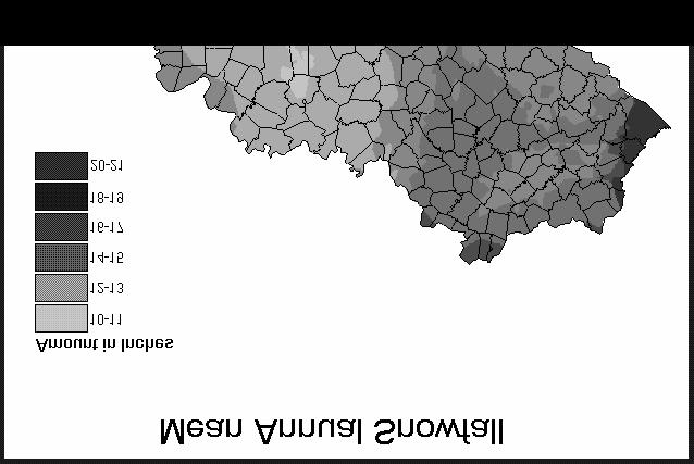
10 Heavy snow warning criteria across Kentucky. > 4 > 5 > 4 > 4 > 4 Kentucky s Vast Topography

11 Other winter weather hazards Wind chill warning Issued when the wind chill is expected to fall to -25 degrees or lower.with at least a 10 mph wind. A wind chill advisory will cover situations where wind chills range between -10 and -24 degrees. High wind warning/advisory High wind warning issued when sustained winds of 40 mph are expected for at least an hour s time or for a non-thunderstorm related wind gust of 58 mph. Advisory criteria is satisfied when sustained winds of 30 mph or gust of 45 mph or greater are expected. Dense fog advisory Widespread dense fog expected to reduce visibilities to less than ½ mile.

12 NOAA Weather Radio
13 Number of Days with at Least One Inch of Snowfall Location Normal Last Winter Bowling Green 3 3 Covington 7 4 Jackson 7 5 Lexington 5 2 Louisville 4 1 Paducah 4 1 Kentucky s Snowiest Months Month Year Snowfall Location December Louisville (Cherokee Park) January LaGrange (Oldham County) February " Benham (Harlan County)


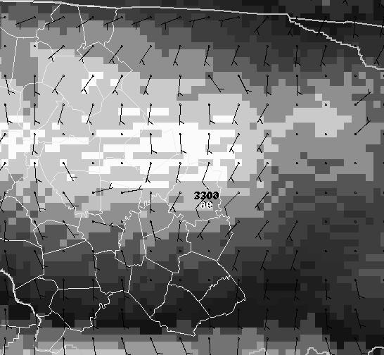
14 January 6, 2002 Tight Snow Gradient
15 HPC Products and Services-Winter Weather Desk Low Tracks Graphic The displayed model and ensemble low positions show the uncertainty of the low positions- the black line represents the HPC preferred track HPC Products and Services Winter Weather Desk Probabilistic Snow Forecasts are issued for 4, 8 and 12 inches, and icing for 0.25 inches

 Seasonality")
16 An graphical example of a snow amount associated with a winter storm warning across southern Kentucky. In this example, the 4 in. of snow illustrated over Bowling Green is forecast to fall within a 6 hour period. Assessing Societal Impacts Timing of Storm (Day of Week / Time of day) Seasonality Type of Snow Post Storm Conditions

17 Derived Winter Weather Impact Graphics Probability of one inch per hour snowfall 00z Friday April Where was the most snow in the country on New Years Eve 1963/64?
18 HAZARDOUS WEATHER OUTLOOK Issued to 7 days, including short term (Day 1), extended (Days 2-7) Concise, generally non-technical information conveying the potential for significant weather hazards in forecast period Emphasis placed in Day 1 and possibly Days 2 and 3; beyond Day 3, more generalized info given about potential hazards Hazards that normally will be discussed: Severe thunderstorm potential in Days 1-3 (and beyond if appropriate) Non-severe storm potential in Day 1 (and beyond as appropriate) Heavy rain and/or flood potential Winter storm outlooks Winter storm watches, warnings, and advisories ERIE NY-GENESEE NY- INCLUDING THE CITIES OF...BUFFALO NY...BATAVIA NY...Lake Effect Snow Warning For This Afternoon And Tonight... A General Snowfall Will Develop This Morning And Produce Accumulations of 2 to 3 Inches By Nightfall. This Snowfall Will Be Accompanied by a Band of Heavier Lake Effect Snow That Will Develop to The North of Buffalo Early This The Afternoon. This Band of Heavy Lake Effect Snow Is Expected to Slowly Drift to The South Across Genesee And North Central Erie County Later This Afternoon And Evening...Where Accumulations of up to 6 Inches Are Possible by Nightfall. The Steadiest And Heaviest Snow For The Buffalo Metropolitan Area Is Expected to Fall Between 2 and 6 PM. Commuters During This Evenings Rush Hour Will Likely Experience Very Difficult Driving Conditions. Snowfall Rates of an Inch or Two an Hour, Combined with a Heavy Volume of Traffic, Could Clog Many of the Major Arteries Around The Metropolitan Area. Motorists Should Be Prepared For a Slow and Difficult Evening commute.

19 Important Processes for Producing Heavy Snow As with warm season weather we need to consider three critical factors for the production of heavy precipitation. Lift Moisture Instability Winter storms are typically are accompanied by strong dynamics which produce synoptic-scale lift. So, the forecaster must diagnose/forecast if Lift will become focused ( km) scale Moisture will be deep enough to produce ice crystals in a region where the temperature is between 13 to -17 C (dendrite formation zone) increase snow to liquid equivalent ratios Instability will be generated to contract and enhance the upward vertical motions over a mesoscale area (possibly linear bands) HPC Winter Weather Desk Forecast Process Climatology of Snow to Liquid Ratios
20
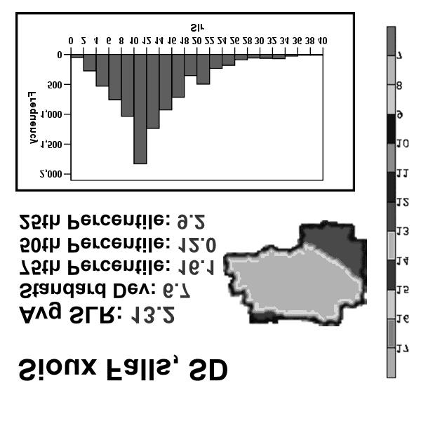
21 The snowfall graph to the right shows the tremendous amount of snow that fell during the month of March 1960 especially across southern Kentucky. The official snowfall total for Bowling Green was 32 inches. This made March 1960 the snowiest month ever! A large portion of southern Kentucky s excessive March snowfall came During the period ranging from the 7 th to the 11 th of March. Bowling Green officially received 27 inches during this period although due to melting and snow compaction, quite a bit less was measured on the ground at any one time.

22 This graph illustrates the snow totals from the mid-january snowstorm of This event gave Louisville almost 17 inches over a 24 hour period. Lightning was observed during the peak of this storm, which gave over 20 inches to some locations northeast of Louisville. Deep snow cover contributed to our state s lowest temperature ever Recorded (-37 degrees). This was set in Shelbyville on January 19 th, The winter of was especially severe due to the persistent cold air masses and snowcover across the state. Measurable snow fell in Kentucky on 19 of the 31 days of January. The worst came on January when a severe blizzard caused KSP to close nearly every road in Kentucky and the National Guard was called into action. Many schools in Kentucky were closed for nearly the entire month of January. The entire state had snowcover through all of February. By the end of the winter, snowfall totals ranged from 31 at Scottsville (Allen County) to 84 at LaGrange (Oldham County). Williamstown (Grant County) reported at least one inch of snow on the ground for 74 days of the season.

23 Recent Major Storms February 15-16, 2003: Ice storm in central Kentucky Frankfort and Lexington hardest hit. 125,000 citizens without power for five days. One fatality in Anderson County. $26.3 million damage. February 3-6, 1998: Major snowstorm in the central and east. 10 to 25 inches of snowfall. The snow was extremely wet, leading to significant damage. Some areas went without power for 2 weeks. Numerous buildings collapsed. Much of the eastern 2/3 of the state was declared a disaster area. $10 million damage. Five fatalities made this our deadliest winter storm since at least 1950, when records begin, tied with the Superstorm of March 1993 when up to 30 of snow fell in the Kentucky Appalachians. Wind Chill Chart
24 Hypothermia Condition where the core body temperature decreases to a level at which normal muscle and brain functions are impaired. There are many factors that can influence susceptibility to hypothermia, including prolonged exposure to cold temperatures. Hypothermia may cause: Drowsiness Unconsciousness Lower heart and breathing rates Severe hypothermia may cause death For those who survive hypothermia, one could suffer from lifelong kidney, liver, and pancreas problems. Kentucky s Biggest Plunge! The temperature at Bradfordsville (Marion County) fell 82 degrees in 24 hours, from 52 degrees January 23, 1963, to -30 the next day.
25 Trivia About how many people die each year in the United States from hypothermia? A)300 B)700 C)850 D)1000 A) 300 B)700 C)850 D)1,000 The answer is
26 Did You Know Between ,555 deaths were attributed to hypothermia. Infants and the elderly are at the greatest risk for cold related illnesses. The answer is A) 3,000-4,000 B)6,000-7,000 C)9,000-10,000 D)12,000-13,000


27 Climatology of Freezing Precipitation Climatology of frequency of freezing precipitation (ZR/ZL) in hours per years (30 years of data)

28 Example Soundings

29 Improve communication to public We re here to listen to your needs We use your data!

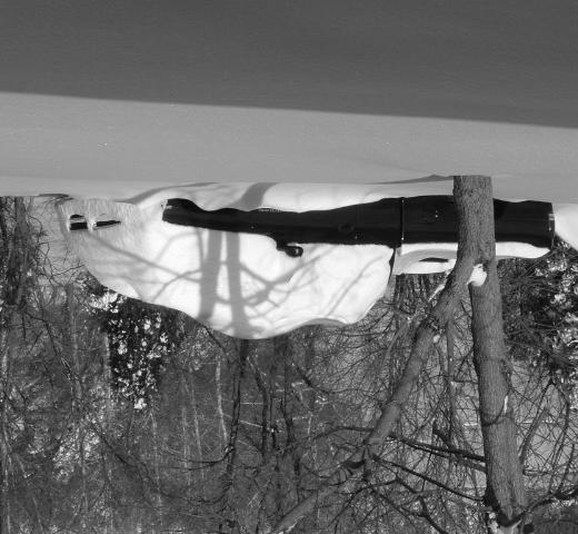
30 Black Ice Transparent coating of ice on a roadway surface. While not truly black, it allows the usually black asphalt to be seen through it. Deposited by freezing rain, mist, or fog It often has a dull appearance rather than the expected gloss. Can be hazardous when driving or walking. Black Ice Picture


31 WEBSITE FORECASTS Questions, Comments, Suggestions?
Severe Weather Watches, Advisories & Warnings
 Severe Weather Watches, Advisories & Warnings Tornado Watch Issued by the Storm Prediction Center when conditions are favorable for the development of severe thunderstorms and tornadoes over a larger-scale
Winter Weather. National Weather Service Buffalo, NY
 Winter Weather National Weather Service Buffalo, NY Average Seasonal Snowfall SNOWFALL = BIG IMPACTS School / government / business closures Airport shutdowns/delays Traffic accidents with injuries/fatalities
HAZARD DESCRIPTION... 1 LOCATION... 1 EXTENT... 1 HISTORICAL OCCURRENCES...
 WINTER STORM HAZARD DESCRIPTION... 1 LOCATION... 1 EXTENT... 1 HISTORICAL OCCURRENCES... 3 SIGNIFICANT PAST EVENTS... 4 PROBABILITY OF FUTURE EVENTS... 5 VULNERABILITY AND IMPACT... 5 Hazard Description
IWT Scenario 2 Integrated Warning Team Workshop National Weather Service Albany, NY October 31, 2014
 IWT Scenario 2 Integrated Warning Team Workshop National Weather Service Albany, NY October 31, 2014 09 10 11 12 13 Scenario 2 Timeline December 9-13 Tue Wed Thu Fri Sat Tue, Dec. 9 @ 5 am 2014 2014 2014
Wind Events. Flooding Events. T-Storm Events. Awareness Alerts / Potential Alerts / Action Alerts / Immediate Action Alerts / Emergency Alerts.
 Information Updated: February of 2016 Our Alert Terms Definitions * Use exactly as seen below * Wind Events Awareness Alert - Strong Winds Potential Alert - Damaging Winds ACTION Alert - Damaging Winds
W I N T E R STORM HAZARD DESCRIPTION
 W I N T E R STORM HAZARD DESCRIPTION... 1 LOCATION... 2 EXTENT... 2 HISTORICAL OCCURRENCES... 4 SIGNIFICANT PAST EVENTS... 4 PROBABILITY OF FUTURE EVENTS... 5 VULNERABILITY AND IMPACT... 5 HAZARD DESCRIPTION
NWS Resources For Public Works
 NWS Resources For Public Works August 28th, 2016 Shawn DeVinny shawn.devinny@noaa.gov Meteorologist National Weather Service Twin Cities/Chanhassen, MN 1 APWA 2016 PWX 8/28/2016 National Weather Service
Kentucky Weather Hazards: What is Your Risk?
 Kentucky Weather Hazards: What is Your Risk? Stuart A. Foster State Climatologist for Kentucky 2010 Kentucky Weather Conference Bowling Green, Kentucky January 16, 2010 Perspectives on Kentucky s Climate
Snow Measurement Guidelines for National Weather Service Snow Spotters
 Snow Measurement Guidelines for National Weather Service Snow Spotters National Weather Service Forecast Office Northern Indiana October 2004 Table of Contents Introduction 3 Definitions.. 3 Relaying Real
The hydrologic service area (HSA) for this office covers Central Kentucky and South Central Indiana.
 for this office covers Central Kentucky and South Central Indiana.") January 2012 February 13, 2012 An X inside this box indicates that no flooding occurred within this hydrologic service area. January 2012 continued the string of wet months this winter. Rainfall was generally
January 2012 February 13, 2012 An X inside this box indicates that no flooding occurred within this hydrologic service area. January 2012 continued the string of wet months this winter. Rainfall was generally
Section 12. Winter Storms
 Section 12. Winter Storms Contents Why Winter Storms are a Threat...12-1 Hazard Profile...12-1 History of Winter Storms...12-4 People and Property at Risk...12-7 Potential Damages and Losses...12-7 Why
Winter Storm Update. Through Late Afternoon: Jacksonville, FL Weather Forecast Office. Northeast Florida and Southeast Georgia
 Winter Storm Update Through Late Afternoon: Winter Storm Warning for all of Southeast GA and portions of Suwannee Valley and I-10 Corridor west of Jacksonville. Dangerous ice storm expected from Live Oak
Goals of Presentation
 Hydrometeorlogical Prediction Center (HPC) Forecast Operations Branch Winter Weather Desk Dan Petersen Dan.Petersen@noaa.gov 301-763-8201 Review HPC winter weather desk forecasts Review winter weather
NWS Resources For School Districts
 NWS Resources For School Districts January 23rd, 2017 Shawn DeVinny shawn.devinny@noaa.gov Meteorologist National Weather Service Twin Cities/Chanhassen, MN Outline Watches/Warnings/Advisories Example
Winter Weather Threat Friday night and Saturday January 7, 2017
 Winter Weather Threat Friday night and Saturday January 7, 2017 National Weather Service Newport/Morehead City, NC Date/Time Created: 1/6/2017, 6 AM EST Winter Weather Threat Summary Tonight and Saturday
2011 Year in Review TORNADOES
 2011 Year in Review The year 2011 had weather events that will be remembered for a long time. Two significant tornado outbreaks in April, widespread damage and power outages from Hurricane Irene in August
NATIONAL WEATHER SERVICE
 January 2016 February 9, 2016 This was a dry month across the HSA despite one large and several smaller snowfalls. Most locations ended up 1-2 inches below normal for the month. The driest locations at
A Preliminary Severe Winter Storms Climatology for Missouri from
 A Preliminary Severe Winter Storms Climatology for Missouri from 1960-2010 K.L. Crandall and P.S Market University of Missouri Department of Soil, Environmental and Atmospheric Sciences Introduction The
1st Annual Southwest Ohio Snow Conference April 8, 2010 Abner F. Johnson, Office of Maintenance - RWIS Coordinator
 1st Annual Southwest Ohio Snow Conference April 8, 2010 Abner F. Johnson, Office of Maintenance - RWIS Coordinator The Ohio Department of Transportation ODOT has approximately 5500 full-time employees
Coastal Storm this Weekend
 Weather Briefing Prepared 9 AM EST Feb 5, 2010 Joe Miketta Warning Coordination Meteorologist NOAA s National Weather Service Philadelphia/Mt. Holly NJ Forecast Office 609-261 261-6602 6602 x223 Joseph.Miketta@noaa.gov
SIGNIFICANT EVENTS Severe Storms November 1994 January 1996 August 1998 and May 2000 March 2002 May 2002 Champaign County
 SIGNIFICANT EVENTS Severe Storms November 1994 On Nov. 1, 1994, high winds gusted over 60 mph at times across the northwest third of Ohio. The highest measured wind gust was 63 mph at Columbus Grove (Putnam).
Weather can change quickly...are you on top of the changes?
 Weather Access Bob Glancy NOAA National Weather Service, Boulder, CO Near Cedar Point, CO May 9, 2004 Weather can change quickly...are you on top of the changes? National Weather Service Local offices:
Jan 7, 2017 Winter Weather Event
 Jan 7, 2017 Winter Weather Event Decision Support Briefing # 5 Assessment for northeast South Carolina & southeast North Carolina National Weather Service Wilmington NC 4 PM EST Friday January 6, 2017
Weather Basics. Challenges of Winter Weather Forecasting Along the East Coast North American Snow Conference 5/23/16
 Challenges of Winter Weather Forecasting Along the East Coast Sara Croke sara@weatherornot.com Sullivan Brown sully@weatherornot.com @WeatherorNotInc /WeatherOrNotInc 913.722.3955 Weather Basics Moisture
NOAA s National Weather Service Philadelphia/Mt. Holly NJ. Summary. Changes
 Summary A crippling and potentially historic east coast snow storm will lead to blizzard conditions and major coastal flooding for portions of the area this weekend. Changes Blizzard Warning has been expanded
Issued by: National Weather Service San Joaquin Valley - Hanford CA. Issue time: 409 AM PST Wed Jan
 Forecast Information Location: New_Exchequer_Dam Updated: January 16, 2019, 11:45 am NWS Weather Discussion: Issued by: National Weather Service San Joaquin Valley - Hanford CA Issue time: 409 AM PST Wed
SPEARFISH FIRE DEPARTMENT POLICIES AND PROCEDURES
 SPEARFISH FIRE DEPARTMENT POLICIES AND PROCEDURES Page 1 of 5 Volume: Operation Section: 20.00 Number: 20.09 Subject: Weather Watches, Warnings, Advisory s and Spotter Activation Date Issued: 28 March
Champaign-Urbana 1998 Annual Weather Summary
 Champaign-Urbana 1998 Annual Weather Summary ILLINOIS STATE WATER SURVEY Audrey Bryan, Weather Observer 2204 Griffith Dr. Champaign, IL 61820 wxobsrvr@sparc.sws.uiuc.edu The development of the El Nìno
January 2008 Climate Summary
 Joseph Mays (765) 494-6574 Feb 5, 2008 http://www.iclimate.org Summary January 2008 Climate Summary January was a mix bag of conditions, with an oscillatory pattern developing. We experienced phases of
2018 Year in Review for Central and Southeast Illinois By: Chris Geelhart, Meteorologist National Weather Service, Lincoln IL
 By: Chris Geelhart, Meteorologist National Weather Service, Lincoln IL While 2018 featured some significant out-of-season weather, including below zero temperatures in April and 90-degree highs in early
Monthly Long Range Weather Commentary Issued: APRIL 18, 2017 Steven A. Root, CCM, Chief Analytics Officer, Sr. VP,
 Monthly Long Range Weather Commentary Issued: APRIL 18, 2017 Steven A. Root, CCM, Chief Analytics Officer, Sr. VP, sroot@weatherbank.com MARCH 2017 Climate Highlights The Month in Review The average contiguous
Weather Briefing for Pennsylvania Feb Outlook Prepared 02/11/14 2 pm EST
 Weather Briefing for Pennsylvania Feb. 12-13 Outlook Prepared 02/11/14 2 pm EST Prepared by: National Weather Service State College, PA (Peter.Jung@noaa.gov) Pennsylvania Weather Overview A significant
A Prepared Marylander Creates a Resilient Maryland
 Maryland Emergency Management Agency Operations Directorate Hazardous Winter Weather Outlook Briefing March 5, 2013 0800 A Prepared Marylander Creates a Resilient Maryland A strong low pressure will track
Understanding Michigan snowfall. Jim Keysor - NWS Gaylord
 Understanding Michigan snowfall Jim Keysor - NWS Gaylord Presentation Outline Topics Background information on lake effect Radar and lake effect snow Wind direction and lake effect Lake Enhanced snow Elevation
Winter Storm Today into Tonight
 Winter Storm Today into Tonight Decision Support Briefing #2 As of 6 AM Wednesday, February 20, 2019 What Has Changed? Minor adjustments to forecast snow and ice amounts. Main Points Hazard Impacts Location
Jan 7, 2017 Winter Weather Event
 Jan 7, 2017 Winter Weather Event Decision Support Briefing # 4 Assessment for northeast South Carolina & southeast North Carolina National Weather Service Wilmington NC 8 AM EST Friday January 6, 2017
Weather and Climate Summary and Forecast Winter
 Weather and Climate Summary and Forecast Winter 2016-17 Gregory V. Jones Southern Oregon University February 7, 2017 What a difference from last year at this time. Temperatures in January and February
Winter Storm Tomorrow-Tomorrow Night
 Winter Storm Tomorrow-Tomorrow Night Decision Support Briefing #1 As of 4:30 PM Tuesday, February 19, 2019 What Has Changed? Initial Briefing Main Points Hazard Impacts Location Timing Snow Snow will create
The Weather Wire. Contents: Summer 2018 Outlook. Summer 2018 Outlook Drought Monitor May Summary/Statistics June Preview Rainfall Totals
 The Weather Wire June 2018 Volume 25 Number 6 Contents: Summer 2018 Outlook Drought Monitor May Summary/Statistics June Preview Rainfall Totals Summer 2018 Outlook June 1 st marked the first day of meteorological
IWT Scenario 1 Integrated Warning Team Workshop National Weather Service Albany, NY October 31, 2014
 Integrated Warning Team Workshop National Weather Service Albany, NY October 31, 2014 23 24 25 26 27 Scenario 1 Timeline November 23-27 Sun Mon Tue Wed Thu Thanksgiving Day Sunday, Nov. 23 @ 430 pm NWS
The hydrologic service area (HSA) for this office covers Central Kentucky and South Central Indiana.
 for this office covers Central Kentucky and South Central Indiana.") MONTH YEAR January 2011 February 15, 2011 X An X inside this box indicates that no flooding occurred within this hydrologic service area. January 2011 was drier than normal in all locations in the area.
MONTH YEAR January 2011 February 15, 2011 X An X inside this box indicates that no flooding occurred within this hydrologic service area. January 2011 was drier than normal in all locations in the area.
Significant Coastal Storm Today through Thursday, 11/7-8. Weather Briefing
 Significant Coastal Storm Today through Thursday, 11/7-8 Weather Briefing Prepared 10:00 am EST Wednesday, November 7, 2012 Presented by Gary Conte, Warning Coordination Meteorologist NOAA s National Weather
National Wildland Significant Fire Potential Outlook
 National Wildland Significant Fire Potential Outlook National Interagency Fire Center Predictive Services Issued: September, 2007 Wildland Fire Outlook September through December 2007 Significant fire
Definitions Weather and Climate Climates of NYS Weather Climate 2012 Characteristics of Climate Regions of NYS NYS s Climates 1.
 Definitions Climates of NYS Prof. Anthony Grande 2012 Weather and Climate Weather the state of the atmosphere at one point in time. The elements of weather are temperature, t air pressure, wind and moisture.
Winter Storm Briefing #3 Monday Evening Wednesday Evening
 Winter Storm Briefing #3 Monday Evening Wednesday Evening Tuesday March 14, 2017 Disclaimer: The information contained within this briefing is time-sensitive. Do not use after 4AM Wednesday. Applies to
WINTER STORM Annex II
 WINTER STORM Annex II I. PURPOSE A. This annex has been prepared to ensure a coordinated response by state agencies to requests from local jurisdictions to reduce potential loss of life and to ensure essential
Weather Briefing. Coastal Storm Monday-Wednesday Dec 8-10, National Weather Service. Prepared 12/8/14 6:30 AM
 Weather Briefing Coastal Storm Monday-Wednesday Dec 8-10, 2014 National Weather Service http://www.weather.gov/nyc Prepared 12/8/14 6:30 AM Overview of Potential Hazards A strong low pressure system will
****Approaching Winter Storm ****
 ****Approaching Winter Storm **** 02/12/2013 The Flemington Borough Office of Emergency Management is currently monitoring the incoming winter storm expected to impact our area starting Thursday morning
Coastal Storm. Wednesday through Friday, 3/6-8/2013 Weather Briefing
 Coastal Storm Wednesday through Friday, 3/6-8/2013 Weather Briefing Prepared 2:00 PM EST Wednesday, March 6, 2013 National Weather Service New York, NY Purpose of Briefing Promote Situational Awareness
How strong does wind have to be to topple a garbage can?
 How strong does wind have to be to topple a garbage can? Imagine winds powerful enough to pick up a truck and toss it the length of a football field. Winds of this extreme sometimes happen in a tornado.
May 2016 Volume 23 Number 5
 The Weather Wire May 2016 Volume 23 Number 5 Contents: Winter Summary Current Colorado and West-wide Snow Pack Drought Monitor April Summary/Statistics May Preview Snowfall Totals Winter Summary The Front
Major Winter Storm to impact Western Washington. 17 January 2012 National Weather Service Seattle/Tacoma
 Major Winter Storm to impact Western Washington 17 January 2012 National Weather Service Seattle/Tacoma Current Warnings Winter Storm Warning for all of Western Washington, except: Northwest interior Extreme
Champaign-Urbana 1999 Annual Weather Summary
 Champaign-Urbana 1999 Annual Weather Summary ILLINOIS STATE WATER SURVEY 2204 Griffith Dr. Champaign, IL 61820 wxobsrvr@sws.uiuc.edu Maria Peters, Weather Observer A major snowstorm kicked off the new
Eastern Shore Weather and Climate. Bill Sammler Warning Coordination Meteorologist National Weather Service Wakefield, VA
 Eastern Shore Weather and Climate Bill Sammler Warning Coordination Meteorologist National Weather Service Wakefield, VA About The NWS The National Weather Service is: A Federal Government Agency Part
CHAPTER THREE SECTION 3.12 HAZARD PROFILE-SEVERE WINTER WEATHER
 CHAPTER THREE SECTION 3.12 HAZARD PROFILE-SEVERE WINTER WEATHER AFFECTED JURISDICTIONS COMMUNITIES Unincorporated Pottawatomie County Town of Asher Town of Bethel Acres Town of Brooksville Town of Earlsboro
Exercise Brunswick ALPHA 2018
 ALPHA Exercise Brunswick ALPHA 2018 Who we are (our structure) What we do (our forecasts) How you can access the information Tropical cyclone information (basic) Overview of the products used for Exercise
The Pennsylvania Observer
 The Pennsylvania Observer April 2, 2009 March 2009 Pennsylvania Weather Recap Prepared by Curt Harpster For the month of March the saying, In like a lion and out like a lamb really fit the pattern quite
Champaign-Urbana 2001 Annual Weather Summary
 Champaign-Urbana 2001 Annual Weather Summary ILLINOIS STATE WATER SURVEY 2204 Griffith Dr. Champaign, IL 61820 wxobsrvr@sws.uiuc.edu Maria Peters, Weather Observer January: After a cold and snowy December,
Northeastern United States Snowstorm of 9 February 2017
 Northeastern United States Snowstorm of 9 February 2017 By Richard H. Grumm and Charles Ross National Weather Service State College, PA 1. Overview A strong shortwave produced a stripe of precipitation
National Wildland Significant Fire Potential Outlook
 National Wildland Significant Fire Potential Outlook National Interagency Fire Center Predictive Services Issued: April 1, 2008 Next Issue: May 1, 2008 Wildland Fire Outlook April 2008 through July 2008
Storm and Storm Systems Related Vocabulary and Definitions. Magnitudes are measured differently for different hazard types:
 Storm and Storm Systems Related Vocabulary and Definitions Magnitude: this is an indication of the scale of an event, often synonymous with intensity or size. In natural systems, magnitude is also related
WEATHER FORECASTING Acquisition of Weather Information WFO Regions Weather Forecasting Tools Weather Forecasting Tools Weather Forecasting Methods
 1 2 3 4 5 6 7 8 WEATHER FORECASTING Chapter 13 Acquisition of Weather Information 10,000 land-based stations, hundreds of ships and buoys; four times a day, airports hourly Upper level: radiosonde, aircraft,
The hydrologic service area (HSA) for this office covers Central Kentucky and South Central Indiana.
 for this office covers Central Kentucky and South Central Indiana.") NWS Form E-5 (04-2006) NATIONAL OCEANIC AND ATMOSPHERIC ADMINISTRATION (PRES. BY NWS Instruction 10-924) NATIONAL WEATHER SERVICE MONTHLY REPORT OF HYDROLOGIC CONDITIONS HYDROLOGIC SERVICE AREA (HSA) Louisville
NWS Form E-5 (04-2006) NATIONAL OCEANIC AND ATMOSPHERIC ADMINISTRATION (PRES. BY NWS Instruction 10-924) NATIONAL WEATHER SERVICE MONTHLY REPORT OF HYDROLOGIC CONDITIONS HYDROLOGIC SERVICE AREA (HSA) Louisville
Snowfall totals by zip code in ny
 Snowfall totals by zip code in ny 4-1-2018 Snowfall forecasts increased overnight for New Jersey with a large portion of the state expected to get 8 to 12 inches from 'bomb cyclone' nor'easter. NOAA National
Integrated Warning Team Workshop National Weather Service - Albany, NY October 31, 2014
 Integrated Warning Team Workshop National Weather Service - Albany, NY October 31, 2014 Scenario #1 = November 23 27 (Note: November 27 = Thanksgiving) Initial Overview: A storm system will track from
Active Winter Weather Pattern February 4th-9th
 Active Winter Weather Pattern February 4th-9th Prepared 1230 PM EST Tuesday, February 4, 2014 Gary Szatkowski NOAA s NJ Forecast office http://www.erh.noaa.gov/phi/ Purpose of Briefing Briefing #6 Promote
HAZARD IDENTIFICATION
 6.5.9 Winter Storms 6.5.9.1 Hazard Identification Description of the Winter Storm Hazard A winter storm can range from a moderate snow over a period of a few hours to blizzard conditions with blinding
Minnesota s Climatic Conditions, Outlook, and Impacts on Agriculture. Today. 1. The weather and climate of 2017 to date
 Minnesota s Climatic Conditions, Outlook, and Impacts on Agriculture Kenny Blumenfeld, State Climatology Office Crop Insurance Conference, Sep 13, 2017 Today 1. The weather and climate of 2017 to date
California OES Weather Threat Briefing
 California OES Weather Threat Briefing Wednesday, January 16, 2019 9:00 AM PST Day 1: Strong winds, heavy mountain snow and heavy rain with isolated thunderstorms across much of the state through Thursday
The 2015 NWS Spring and Summer Weather Update
 http://weather.gov The 2015 NWS Spring and Summer Weather Update Western North Carolina severe weather climatology Tony Sturey, WCM Greenville/Spartanburg, SC North Carolina Spring and Summer Outlooks
The Weather Wire. Current Colorado Snowpack. Contents:
 The Weather Wire January 2019 Volume 26 Number 1 Contents: Current Colorado Snowpack Denver Snowfall Since 1999-2000 Denver 2018 Climate Review Drought Monitor December Summary/Statistics January Preview
National Situation Report As of 5:00 a.m. EDT Tuesday, April 4, 2017
 Overview National Situation Report As of 5:00 a.m. EDT Tuesday, April 4, 2017 Table Of Contents Current Operations Monitoring Recovery National Response Coordination Center: Not Activated National Watch
NWS FORM E-5 U.S. DEPARTMENT OF COMMERCE I HYDRO SERVICE AREA NOAA, NATIONAL WEATHER SERVICE I Indianapolis, IN MONTHLY REPORT
 NWS FORM E-5 U.S. DEPARTMENT OF COMMERCE I HYDRO SERVICE AREA NOAA, NATIONAL WEATHER SERVICE I Indianapolis, IN. 1-------------------- MONTHLY REPORT OF RIVER AND FLOOD CONDITIONSI REPORT FOR I November
Guided Notes Weather. Part 2: Meteorology Air Masses Fronts Weather Maps Storms Storm Preparation
 Guided Notes Weather Part 2: Meteorology Air Masses Fronts Weather Maps Storms Storm Preparation The map below shows North America and its surrounding bodies of water. Country borders are shown. On the
Ch. 3: Weather Patterns
 Ch. 3: Weather Patterns Sect. 1: Air Mass & Fronts Sect. 2: Storms Sect. 3: Predicting the Weather Sect. 4: Weather forecasters use advanced technologies Ch. 3 Weather Fronts and Storms Objective(s) 7.E.1.3
Monthly Long Range Weather Commentary Issued: NOVEMBER 16, 2015 Steven A. Root, CCM, Chief Analytics Officer, Sr. VP, sales
 Monthly Long Range Weather Commentary Issued: NOVEMBER 16, 2015 Steven A. Root, CCM, Chief Analytics Officer, Sr. VP, sales sroot@weatherbank.com OCTOBER 2015 Climate Highlights The Month in Review The
CropCast Corn and Soybean Report Kenny Miller Tuesday, March 14, 2017
 Accumulated Rainfall (inches) Accumulated GDDs Temperature ( F)/Wind Speed (mph) Precipitation (inches) CropCast Corn and Soybean Report Kenny Miller Tuesday, March 14, 2017 Peoria, IL Regional Forecast
NOAA s National Weather Service Philadelphia/Mt. Holly NJ
 Early Week Coastal Flooding and snow Hazards and Impacts: Coastal Flooding: With the persistent onshore flow, and a new moon today, coastal flooding is expected at high tide through Tuesday morning. Moderate
Monthly Long Range Weather Commentary Issued: February 15, 2015 Steven A. Root, CCM, President/CEO
 Monthly Long Range Weather Commentary Issued: February 15, 2015 Steven A. Root, CCM, President/CEO sroot@weatherbank.com JANUARY 2015 Climate Highlights The Month in Review During January, the average
The Pennsylvania Observer
 The Pennsylvania Observer January 5, 2009 December 2008 Pennsylvania Weather Recap The final month of 2008 was much wetter than average and a bit colder than normal. In spite of this combination, most
CropCast Corn and Soybean Report Kyle Tapley Monday, March 20, 2017
 Accumulated Rainfall (inches) Accumulated GDDs Temperature ( F)/Wind Speed (mph) Precipitation (inches) CropCast Corn and Soybean Report Kyle Tapley Monday, March 20, 2017 Peoria, IL Regional Forecast
UDOT Weather Program Traffic Operations Center
 UDOT Weather Program Traffic Operations Center Presentation Goals You MUST account for weather in your Traffic Management program Provide you with information on proven tools and strategies You NEED a
BASIC UNDERSTANDINGS. Winter Storms. Winter Storm Development. Winter Storm Hazards
 BASIC UNDERSTANDINGS Basic understandings - Winter storms Winter Storms Winter Storm Development 1. Winter storms are large-scale disturbances associated with low-pressure areas called mid-latitude cyclones.
Weather and Climate Summary and Forecast April 2018 Report
 Weather and Climate Summary and Forecast April 2018 Report Gregory V. Jones Linfield College April 4, 2018 Summary: A near Miracle March played out bringing cooler and wetter conditions to the majority
Current Climate Trends and Implications
 Current Climate Trends and Implications Dr. Mark Seeley Professor emeritus Department of Soil, Water, and Climate University of Minnesota St Paul, MN 55108 Crop Insurance Conference September 12, 2018
Building a Weather-Ready Wisconsin
 National Weather Service Session: Building a Weather-Ready Wisconsin WEMA Conference October 11, 2017 Jeff Last National Weather Service Green Bay Today s Presentation NWSChat in EM Operations The June
LECTURE #15: Thunderstorms & Lightning Hazards
 GEOL 0820 Ramsey Natural Disasters Spring, 2018 LECTURE #15: Thunderstorms & Lightning Hazards Date: 1 March 2018 (lecturer: Dr. Shawn Wright) I. Severe Weather Hazards focus for next few weeks o somewhat
A Complex Weather System: Tuesday Afternoon into Thursday March 3 5, 2015
 A Complex Weather System: Tuesday Afternoon into Thursday March 3 5, 2015 Briefing #1, prepared 900 AM EST Tuesday, March 3, 2015 by Meteorologists at NWS - WFO Mount Holly, NJ To promote situational awareness
Summary of November Central U.S. Winter Storm By Christopher Hedge
 Summary of November 12-13 2010 Central U.S. Winter Storm By Christopher Hedge Event Overview The first significant snowfall of the 2010-2011 season affected portions of the plains and upper Mississippi
Jim Witt Long Range Calendar
 Jim Witt Long Range Calendar 2012-2013 November 2012 Toll Free 1-0-287-03 Studio Line (207) 9- Generally 20 40 50 60 70 0 Generally Cloudy, Cool Change Of Rain Or Wet Snow (Heavy) Changing To Rain 1 120
Multi-Jurisdictional Hazard Mitigation Plan. Table C.17 Disaster Declarations or Proclamations Affecting Perry County Presidential & Gubernatorial
 Severe Weather General Severe weather affects the entire Commonwealth and can be expected any time of the year. Severe weather for Perry County is considered to include: blizzards and/or heavy snowfall,
Arizona Climate Summary February 2016 Summary of conditions for January 2016
 January 2016 Temperature and Precipitation Summary Arizona Climate Summary February 2016 Summary of conditions for January 2016 January 1 st 14 th : The new year began with high pressure over the southwest
5.4.9 Severe Winter Weather
 5.4.9 Severe Winter Weather The following section provides the hazard profile (hazard description, location, extent, previous occurrences and losses, probability of future occurrences, and impact of climate
Your Task: Read each slide then use the underlined red or underlined information to fill in your organizer.
 Severe Weather: Tornadoes and Hurricanes Thunderstorms and Lightning S6E4 d. Construct an explanation of the relationship between air pressure, weather fronts, and air masses and meteorological events
Thanksgiving Snow and Arctic Front 25 November 2005 By Richard H. Grumm National Weather Service State College, PA 16801
 Thanksgiving Snow and Arctic Front 25 November 2005 By Richard H. Grumm National Weather Service State College, PA 16801 1. INTRODUCTION An approaching arctic front brought light snow to most of western
Weather and Climate Summary and Forecast December 2017 Report
 Weather and Climate Summary and Forecast December 2017 Report Gregory V. Jones Linfield College December 5, 2017 Summary: November was relatively cool and wet from central California throughout most of
HURRICANES AND TORNADOES
 HURRICANES AND TORNADOES The most severe weather systems are hurricanes and tornadoes. They occur in extremely low pressure systems, or cyclones, when the air spirals rapidly into the center of a low.
Severe Winter Weather in
 Transactions of the Illinois State Academy of Science received 4/19/10 (2010), Volume 103, #3&4, pp. 131-140 accepted 9/6/10 Severe Winter Weather in 2009-2010 Stanley A. Changnon Changnon Climatologist,
Monthly Long Range Weather Commentary Issued: APRIL 1, 2015 Steven A. Root, CCM, President/CEO
 Monthly Long Range Weather Commentary Issued: APRIL 1, 2015 Steven A. Root, CCM, President/CEO sroot@weatherbank.com FEBRUARY 2015 Climate Highlights The Month in Review The February contiguous U.S. temperature
Weather and Climate Summary and Forecast February 2018 Report
 Weather and Climate Summary and Forecast February 2018 Report Gregory V. Jones Linfield College February 5, 2018 Summary: For the majority of the month of January the persistent ridge of high pressure