Automated RSO Stability Analysis. Thomas M. Johnson Analytical Graphics, Inc., 220 Valley Creek Blvd, Exton, PA 19468, USA
|
|
|
- Isaac Lang
- 5 years ago
- Views:
Transcription
1 Automated RSO Stability Analysis Thomas M. Johnson Analytical Graphics, Inc., 220 Valley Creek Blvd, Exton, PA 19468, USA ABSTRACT A methodology for assessing the attitude stability of a Resident Space Object (RSO) using visual magnitude data is presented and then scaled to run in an automated fashion across the entire satellite catalog. Results obtained by applying the methodology to the Commercial Space Operations Center (COMSpOC) catalog are presented and summarized, identifying objects that have changed stability. We also examine the timeline for detecting the transition from stable to unstable attitude 1. INTRODUCTION Resident Space Object (RSO) visual magnitude data has been historically difficult to obtain, limited to those participating in dedicated observation campaigns organized by academia, civil space agencies (NASA, ESA, JAXA, etc.), or elements of the US government (AFRL, AFSPC, etc.). This issue is quickly going away in recent years with the significant growth of small telescopes deployed by commercial companies such as Exo Analytics, Inc. and Las Cumbres Observatory Global Telescope network. The partnership between these companies and AGI s Commercial Space Operations Center (ComSpOC) inspired us to examine ways to combine their use astrometric and magnitude data to do large scale analysis across all objects in a catalog. RSO stability analysis is ideally performed by collecting long duration tracks over several hours a night with each track consisting of a measurement every 2-60 seconds. One model for RSO visual magnitude is shown below [1] m = log AρF ϕ + 5 log r = cross-sectional area = albedo = range to the object = 1 specular sphere or 4 = 2 + lambertian sphere 3 (1) The magnitude depends on the observed area, the material properties, and range to the RSO. The RSO shape, material properties, and attitude stability can then be assessed as the analyst looks for higher frequency content in the magnitude data to indicate tumbling and a rotation speed. This level of analysis requires long periods of observation time dedicated to each RSO, often across multiple nights [2, 3, 4, 6]. Collecting magnitude data over a year or longer supports analysis of the RSO under different sensor and lighting geometries to build fingerprints of objects of interest [5]. However there s a tradeoff between dwell time on a given RSO and collecting against multiple RSOs. We are trying to mitigate that trade off by introducing an analytical method that can work with multiple short collects. The ComSpOC and its sensor partners routinely collect optical tracking data on many RSOs, but other than selected high interest RSOs these collections are short duration tracks lasting just a few minutes. The primary goal is to obtain astrometric data to support catalog maintenance and space situational awareness of the RSO s orbit and maneuver behavior. The track collection frequency varies from 1-2 tracks a night to as often as depending on the nature and history of the RSO. At first glance this collection frequency does not appear to be well suited for stability analysis, but our experiments have shown that is possible, albeit with some limitations. This paper introduces a methodology for exploiting short duration track magnitude information to perform stability analysis and identify RSOs worthy of a more detailed assessment using longer duration tracks. RSO s that transition
2 from stable to unstable (or vice versa) are of particular interest as this may suggest an on-orbit failure or other change in operational behavior. 2. HYPOTHESIS A three-axis stabilized RSO in geosynchronous orbit has a relative body orientation to the sensor that changes very little over the course of night as the body is typically nadir pointing by design. The magnitude variation is driven by the changing orientation of the solar panels (sun tracking) or other deployed elements (steerable antennas, etc.) and the differences in material properties as the RSO is lit from different sides. As a result the magnitude data varies slowly throughout the night. The signature is generally repeatable from night to night and from season to season over a year. Spin stabilized RSOs exhibit a similar signature since they are stable in 2 axes and the spin axes is relatively perpendicular to the observer (ignoring the seasonal Sun declination angle variation). We can therefore assess the RSO s attitude stability by looking at the frequency content of the magnitude data. If the object is three-axis stabilized we expect to see a strong low frequency signature. An unstable object will not have this signature, but may instead show high frequency content. Low and high frequency are relative to the expected variation of the course of one night. We can then repeatedly evaluate the frequency content over a long period of time to produce a classic waterfall plot and use this to assess whether the object s stability is changing. 2.1 Challenges Frequency analysis is classically performed using standard signal processing methods such as Discrete Fourier Transform (DFT) to produce a periodogram or power spectrum plot. Unfortunately visual magnitude data has some unique characteristics that are not present in a standard signal processing problems: Data is not evenly spaced this is typically driven by the sensor integration time. Typically the sensor integration time is constant during a track but not all frames may be usable, leading to irregularly spaced points. Multiple sensors may be observing at the same time but are not typically synchronized. This introduces overlapping measurement time grids sets. Each sensor also has its own integration time. The sensors can only operate under the proper lighting conditions (e.g. the RSO is lit and the sensor is in darkness ) and when the RSO is in view of the sensor geometrically (e.g. above the horizon). The sensor may be unable to observe due to weather or sensor maintenance issues. It s tempting to try to avoid these problems by resampling (interpolation) or extrapolating the observed data to obtain a nice regularly spaced measurement grid. But you should be very cautious in your treatment of missing data between tracks or between nights. The absence of data is not the same as saying that the data points are zero (or other assumed value) Lomb-Scargle Periodogram The traditional astronomy community has been dealing with these same issues for many years and has developed approaches for dealing with them. One of the primary analysis tools employed is known as the Lomb-Scargle Periodogram [7, 8]. Our analysis is based on this technique. Others [4] have also examined the use of the Lomb- Scargle technique and found it suitable in many cases. The classic DFT approach calculates the cosine and sine amplitude coefficients on a regularly spaced frequency grid (determined by the sampling frequency and number of sample points). A DFT based periodogram illustrates the relative power level at each of the sample frequencies. The Lomb-Scargle algorithm allows the analyst to pick a set of frequencies of interest and performs a least squares fit at each frequency to determine the cosine and sine amplitude coefficients. Since it s simply choosing a frequency and solving for the coefficients that best fit the observed data points it eliminates the need for the measurements to be regular spaced in time and allows for large gaps in the data set.
3 We can calculate the Lomb-Scargle periodogram over a span of magnitude data and use the observed frequency content to assess the satellite stability. Before processing the data we remove any constant bias so that the strong frequency component at zero frequency doesn t bleed into our frequencies of interest. Stable RSO attitude orientation and visual magnitude varies on the same order as one orbit period which suggests the frequencies of interest. We calculate the RSO s orbit period T using a recent state vector and generate a set of evenly spaced periods of interest from 0 to 1.5T. The period samples are transformed into the frequency domain to define our sample frequencies. Note that the sample frequencies are not evenly spaced, nor is there a constraint on the number of frequencies that can be analyzed. But, like a traditional DFT based approach you can t extract more frequency content than the underlying measurement spacing supports. The DFT is limited by the measurement sampling and Nyquist s theorem. A Lomb-Scargle analysis has an absolute frequency limit governed by the minimum spacing between any two points. This topic is addressed in more detail in [9]. 2.3 Error Sources There are a number of potential errors sources that we considered in our analysis: Obs association Measurement white noise Range correction The first one is the most concerning from track to track and night to night are we sure that we actually observed the same object? We mitigate this by leveraging the high accuracy orbit solutions and observation association algorithms within AGI s SSA Software Suite as used within the ComSpOC. The magnitude measurement white noise errors are typically around 0.05 (1 ). This is sensor dependent but is a reasonable baseline value. The magnitude varies with the range from the sensor to the RSO. From equation 1 we can solve for the magnitude difference introduced by a range variation Δ = 5 log (2) where and are the two different ranges. A sensor observing a typical GEO RSO directly overhead (zenith) versus one on the horizon has r = km = km Δm = 5 log r r = 0.33 (3) Practically speaking an optical telescope rarely observes all the way down to the horizon. A typical operating limit is a ground elevation angle of 20 degrees yielding Δm = 5 log r r = 0.22 (4) The range variation isn t significant relative to the attitude variation so we chose to ignore it and treat it as noise. The error is clearly correlated though and not a true Gaussian error source. But it s convenient to treat it as such with σ = = (5) It s worth noting the range sigma is of the same order of magnitude as the sensor white noise. If the range varied more significantly such as when tracking an RSO in a highly elliptical orbit then the proper range corrections should be applied to normalize the magnitude data before further processing. For high altitude circular orbits the magnitude
4 variation due to range from sensor to sensor is minimal. Treating the range and measurement errors as independent Gaussian sources gives us an expected error statistics of σ (6) 3. SIMULATED RESULTS We simulated several situations to test the hypothesis and implementation. Figures 1a and 1b illustrate the behavior of a sinusoid (as seen in the equation below) with a period of 1 day and the same signal with half the data available during the night. Sample measurements were generated every 5 minutes. This simple model produces a periodic visual magnitude signature similar to observed on-orbit patterns on known stable objects. 14 2sin 2 (7) Fig. 1a. Sine Signal Fig. 1b. Nightly Sine Signal The strong peak at a period of 1 day in Fig 1a is expected. The Fig. 1b results were initially quite surprising we see a much reduced peak at 1 day and additional peaks at 0.5 and 0.33 days. After further review we realized that when the signal is detrended to remove the mean value the new analysis signal is not a sine wave and the existence of additional peaks should be expected. The addition of white noise ( 0.1) to the nightly sine signal has little impact on the frequency signature (Fig. 2a) and a nightly constant value signal with white noise shows no frequency content (Fig 2b), as expected. The signature peaks at 0.5 and 0.33 days remain visible even when 1 (although the peak amplitude are smaller).
5 Fig. 2a. Nightly Sine + Noise Signal Fig. 2b. Constant + Noise Signal The test signals examined so far have had data available all night long in practice this is never the case. We can simulate a more realistic schedule using the following algorithm. A track has measurements every 30 seconds. The track duration varies uniformly between 1 and 5 minutes (modeled as a discrete uniform random draw between 1 and 6). The number of tracks a night varies uniformly between 0 and 4 (modeled as a discrete uniform random draw between 0 and 4). Track spacing within a night is random. Fig. 3a. Tracks per Night in U[0.4] Fig. 3b. Tracks per Night in U[0, 9]
6 The peak in Fig. 3a at 0.5 days is still clearly visible. Fig 3b illustrates another run where the number of tracks a night is varied from 0 to 9 - the desired signature is very visible. We perturbed the parameters to determine which were most significant for obtaining a clean frequency signature. Unsurprisingly it s the number of tracks per night and not the measurement density or track duration (all other things being equal). Care should be taken to collect tracks throughout an orbit in order to get a proper sampling of the overall magnitude signature. Overall, the longer the analysis time span the more tracks and points we ll get and the better the frequency resolution will be (narrower peaks). The underlying assumption though is that the object s stability (good or bad) hasn t changed during the analysis span. We ll see examples later on where this is not the case. The test runs using a well behaved representative signal gives us confidence that the signature can be observable using real world tracks, even under relatively sparse conditions. 4. OBSERVED RESULTS Analyses were performed using measurements on several RSOs whose stability is known a-priori (or hypothesized): Fig. 4 shows GALAXY-15 (SSN ID 28884), an active three-axis stabilized communications RSO in geostationary orbit. It s well tracked because it also serves as a sensor calibration satellite since it hosts a Wide Area Augmentation System (WAAS) payload [CITE TJ CAL PAPER]. The analysis period was 30 days in the Spring of The first subplot is a graph of all the magnitude data. The second subplot is the same, but with the time axis folded over a duration of one orbit period. The daily periodic signature is evident in this plot and the overall shape supports the use of our original test signal. The last two subplots show the frequency content. The signature peaks are evident in the long-term periodogram, indicating the object is stable. Note how narrow the peaks are since we have a large number of data points to work with. The short-term periodogram shows no significant high frequency content. Fig. 5 shows a similar plot for TDRS 3. It s in an inclined GEO orbit but still shows a strong signal of being 3-axis stabilized. Fig. 5 shows a similar plot for INMARSAT 3-F4. This data was obtained after it was boosted into a supersync orbit for disposal. It s assumed that after all the on-board systems were turned off that the object began to tumble. The periodogram signatures are quite flat, supporting this hypothesis. Fig. 6 shows the results for sparsely tracked GAOFEN-4. This is an imagery satellite in GEO orbit and believed to be 3-axis stabilized. The long-term periodogram signature supports this hypothesis. Fig. 7 shows the results for BRASILSAT B1 (SSN 23199), a sparsely tracked, retired communications satellite in supersync orbit. One might expect that this object is tumbling, but the long-term periodogram suggests that it has some stability. This spacecraft was built on a Hughes (now Boeing) HS-376 satellite bus. The HS-376 bus is spin stabilized at 50 RPM in active operations. It s not known whether it kept the spin rate after disposal or was despun as part of the disposal process. No spin rate is observable in the short term periodogram, but this may simply be because it s spinning to fast to be properly sampled with the sensor integration time. Another explanation is that the cylindrical body shape and symmetrical material properties are such that the spin rate does not induce a significant magnitude variation. Fig. 8 shows the results for DELTA 4 R/B (SSN 40102). The long term periodogram indicates some stability and the short term periodogram indicates a spin rate of ~ 5 RPM. Fig. 9 shows the results for AMOS-5 (SSN 37950), a 3-axis stabilized communication satellite in GEO orbit that failed on November 25, The results are divided into the pre and post failure sets. The prefailure data shows its 3 axis stabilized and the post failure data shows it s not.

7 Fig. 4. GALAXY Axis Stabilized in GEO Orbit

8 Fig. 4. TDRS 3-Axis Stabilized in Inclined GEO Orbit
9 Fig. 5. INMARSAT 3-F4 Tumbling in Supersync Orbit
10 Fig. 6. GAOFEN-4

11 Fig. 7. BRASILSAT B1. Spin Stabilized?, Super Sync GEO.
12 Fig. 8. DELTA-4 R/B. Inertially Stable With a Period of ~5 min.


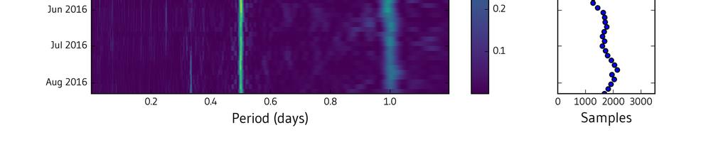
13 Fig. 9. AMOS-5. Pre and Post Failure Stability We can expand the analysis method to look at how the RSO s stability evolves over time by building a classic spectrogram or waterfall display showing the frequency content as a function of time. This is done by applying the
14 Lomb-Scargle methodology across sliding time window of data. The time windows overlap each other by an analyst defined percentage. The analyst defines the window length and overlap percentage and has to tradeoff between long windows (to get good frequency resolution) and short windows (to detect changes in frequency content in a rapid fashion). Fig. 10 shows the results for INMARSAT 3-F4 using a sliding window length of 20 days and an overlap of 20%. Notice the typical peaks at 0.5 and 0.33 days. The peaks disappear near the end of April, This RSO is known to have been supersynced on 1 May 2016 as part of a standard end of life disposal process. The subplot on the right hand side indicates how many measurement samples were used in each window. The results suggest that after completing disposal the RSO is no longer stable. Results for TDRS-3 are shown in Fig 11 and indicate that it appears to be stable. Results for NILESAT 101 are shown in Fig 12 and exhibit an unstable signature. The spectrogram is a useful tool for observing a change in stability and serves as a cueing mechanism to initiate longer collections to confirm the behavior. We also saw some signatures that we didn t anticipate and can t explain. Fig. 13 shows a SL 12 R/B (2) (SSN 24897) signature. It s a slow GEO drift orbit, but shows all the signature characteristics of a stable object. Over 16 SL 12 R/B objects have shown a strong stable signature and 300+ others have a weaker signature that is similar. Fig. 10. INMARSAT 3-F4 Spectrogram

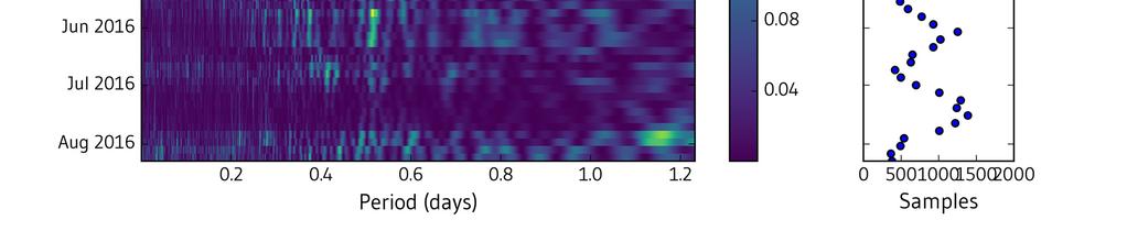
15 Fig. 11. TDRS-3 Spectrogram Fig. 12. NILESAT 101 Spectrogram

16 Fig. 13. SL 12 R/B (2) Spectrogram 5. CONCLUSIONS Our analysis shows that it is possible to perform satellite stability assessment across a large number of objects and detect changes. We think this is a useful technique for identifying RSOs for additional follow up to perform a more detailed stability analysis using longer collections. Our next steps are to automate the change detection process and perform a more detailed simulation using 3D models, material properties, and synthetic scene creation. The optical data in the ComSpOC is primarily focused on objects in GEO, supersync GEO, and GEO crossing orbits. We are currently in the process of characterizing the stability of each object to assemble catalog wide statistics. 6. REFERENCES 1. Retrieved March 03, Cognion, R., Observations and Modeling of GEO Satellites at Large Phase Angles, Advanced Maui Optical and Space Surveillance Technologies Conference; Maui, HI, Binz, C.R, Davis, M. A., Kelm, B. E., Moore, C. I., Optical Survey of the Tumble Rates of Retired GEO Satellites, Advanced Maui Optical and Space Surveillance Technologies Conference; Maui, HI, Linder, E., Silha, J., Schildknect, T., Hager, M., Extraction of Spin Periods of Space Debris from Optical Light Curves ; International Astronautical Congress 2015; Paper IAC-15- A Poole, M., Murray-Krezan, J.; Autonomous Object Characterization with Large Datasets, Advanced Maui Optical and Space Surveillance Technologies Conference; Maui, HI, Michael A. Earl and Gregg A. Wade. "Observations of the Spin-Period Variations of Inactive Box-Wing Geosynchronous Satellites", Journal of Spacecraft and Rockets, Vol. 52, No. 3 (2015), pp Lomb, N. R.; Least-Squares Frequency Analysis of Unequally Spaced Data ; Astrophysics and Space Science, vol. 39, Feb. 1976, p Scargle, J. D.; Studies in Astronomical Time Series Analysis. II Statistical Aspects of Spectral Analysis of Unevenly Space Data ; Astrophysical Journal, Part 1, vol. 263, Dec. 15, 1982, p
17 9. Vio, R.; Diaz-Trigo, M.; Andreani, P., Irregular Time Series in Astronomy and the use of the Lomb-Scargle periodogram ; Astronomy and Computing; Volume 1, February VISIBLE MAGNITUDE OF TYPICAL SATELLITES IN SYNCHRONOUS ORBITS KRAG
Technical analysis of commercially hosted optical payloads for enhanced SSA
 Technical analysis of commercially hosted optical payloads for enhanced SSA Jonathan D. Lowe Analytical Graphics, Inc., Exton, Pennsylvania, 19341. Email:jlowe@agi.com David A. Vallado Center for Space
EXTENSIVE LIGHT CURVE DATABASE OF ASTRONOMICAL INSTITUTE OF THE UNIVERSITY OF BERN
 EXTENSIVE LIGHT CURVE DATABASE OF ASTRONOMICAL INSTITUTE OF THE UNIVERSITY OF BERN Principal Jiří Šilha (1)(2), T. Schildknecht (1), J.-N. Pittet (1), A. Rachman (1), M. Hamara (2) (1) Astronomical Institute,
IAC-17-F Attitude State Evolution of Space Debris Determined from Optical Light Curve Observations
 IAC-17-F1.2.3 Attitude State Evolution of Space Debris Determined from Optical Light Curve Observations Abdul Rachman a *, Thomas Schildknecht a, Jiri Silha a, Jean-Noel Pittet a, Alessandro Vananti a
Photometric Studies of GEO Debris
 Photometric Studies of GEO Debris Patrick Seitzer Department of Astronomy, University of Michigan 500 Church St. 818 Dennison Bldg, Ann Arbor, MI 48109 pseitzer@umich.edu Heather M. Cowardin ESCG/Jacobs
Commercial SSA Catalog Performance
 Commercial SSA Catalog Performance Robert Hall Director, ComSpOC Operations Analytical Graphics, Inc. (AGI) Tom Johnson VP of Engineering Analytical Graphics, Inc. (AGI) ABSTRACT We present a summary over
Optical Studies of Space Debris at GEO - Survey and Follow-up with Two Telescopes
 Optical Studies of Space Debris at GEO - Survey and Follow-up with Two Telescopes Patrick Seitzer University of Michigan, Dept. of Astronomy, 818 Dennison Bldg. Ann Arbor, MI 48109-1090,USA pseitzer@umich.edu
Observation of Light Curves of Space Objects. Hirohisa Kurosaki Japan Aerospace Exploration Agency Toshifumi Yanagisawa.
 Observation of Light Curves of Space Objects Hirohisa Kurosaki Japan Aerospace Exploration Agency Toshifumi Yanagisawa Japan Aerospace Exploration Agency Atsushi Nakajima Japan Aerospace Exploration Agency
USA Space Debris Environment and Operational Updates
 USA Space Debris Environment and Operational Updates Presentation to the 46 th Session of the Scientific and Technical Subcommittee Committee on the Peaceful Uses of Outer Space United Nations 9-20 February
LIGHT CURVE PROPERTIES OF HIGH EARTH OBITAL ROCKET BODIES OBSERVED AT WEIHAI OBSERVATORY OF SHANDONG UNIVERSITY
 LIGHT CURVE PROPERTIES OF HIGH EARTH OBITAL ROCKET BODIES OBSERVED AT WEIHAI OBSERVATORY OF SHANDONG UNIVERSITY Xu Chen, Shao-Ming Hu, Jun-Ju Du, and Di-Fu Guo Shandong University, Weihai, 264209 Weihai,
Photometric Studies of Rapidly Spinning Decommissioned GEO Satellites
 Photometric Studies of Rapidly Spinning Decommissioned GEO Satellites William H. Ryan and Eileen V. Ryan Magdalena Ridge Observatory, New Mexico Institute of Mining and Technology 101 East Road, Socorro,
IAC-10.A Carolin Früh. 1 Astronomical Institute, University of Bern, Switzerland, Thomas Schildknecht 1
 IAC-1.A6.1.9 ANALYSIS OF OBSERVED AND SIMULATED LIGHT CURVES OF SPACE DEBRIS Carolin Früh Astronomical Institute, University of Bern, Switzerland frueh@aiub.unibe.ch Thomas Schildknecht 1 Since 24, the
J. G. Miller (The MITRE Corporation), W. G. Schick (ITT Industries, Systems Division)
, W. G. Schick (ITT Industries, Systems Division)") Contributions of the GEODSS System to Catalog Maintenance J. G. Miller (The MITRE Corporation), W. G. Schick (ITT Industries, Systems Division) The Electronic Systems Center completed the Ground-based
Contributions of the GEODSS System to Catalog Maintenance J. G. Miller (The MITRE Corporation), W. G. Schick (ITT Industries, Systems Division) The Electronic Systems Center completed the Ground-based
Precision Tracking of Decimeter Targets at GEO Distances using the Magdalena Ridge Observatory 2.4-meter Telescope
 Precision Tracking of Decimeter Targets at GEO Distances using the Magdalena Ridge Observatory 2.4-meter Telescope William H. Ryan and Eileen V. Ryan Magdalena Ridge Observatory, New Mexico Institute of
Space Debris Mitigation Activities at ESA
 Space Debris Mitigation Activities at ESA Heiner Klinkrad ESA Space Debris Office H. Klinkrad, ESA, Feb 2011, page 1 Space Debris Environment in 2010 4,765 launches and 251 on-orbit break-ups led to 16,200
A Monitoring and Warning System for Close Geosynchronous Satellite Encounters
 A Monitoring and Warning System for Close Geosynchronous Satellite Encounters R. I. Abbot, R. Clouser E. W. Evans, R. Sridharan SPACE CONTROL CONFERENCE APRIL 2001 This work was performed under a Cooperative
The long-term broadband photometric surveys of inactive AS-7000 and HS-601 box-wing geosynchronous satellites
 The long-term broadband photometric surveys of inactive AS-7000 and HS-601 box-wing geosynchronous satellites M.A. Earl (a) and G.A. Wade (b) (a) Royal Military College of Canada, Kingston ON, earl-m@castor2.ca
RADAR-OPTICAL OBSERVATION MIX
 RADAR-OPTICAL OBSERVATION MIX Felix R. Hoots + Deep space satellites, having a period greater than or equal to 225 minutes, can be tracked by either radar or optical sensors. However, in the US Space Surveillance
Circular vs. Elliptical Orbits for Persistent Communications
 5th Responsive Space Conference RS5-2007-2005 Circular vs. Elliptical Orbits for Persistent Communications James R. Wertz Microcosm, Inc. 5th Responsive Space Conference April 23 26, 2007 Los Angeles,
Results and Analyses of Debris Tracking from Mt Stromlo
 Results and Analyses of Debris Tracking from Mt Stromlo Jizhang Sang 1, Ian Ritchie, Matt Pearson, and Craig Smith EOS Space Systems Pty Ltd, Australia Abstract In the last 2 years, EOS Space Systems has
LIGHT CURVES OF RETIRED GEOSYNCHRONOUS SATELLITES
 LIGHT CURVES OF RETIRED GEOSYNCHRONOUS SATELLITES C. Benson (1), D. J. Scheeres (1), and N. Moskovitz (2) (1) University of Colorado at Boulder, Boulder, CO, 8030, USA, Email: {conor.j.benson, scheeres}@colorado.edu
Swiss Contributions to a Better Understanding of the Space Debris Environment
 Swiss Contributions to a Better Understanding of the Space Debris Environment T. Schildknecht Astronomical Institute, University of Bern (), Switzerland 47 th Session of UNCOPUOS Scientific and Technical
USA Space Debris Environment, Operations, and Policy Updates
 USA Space Debris Environment, Operations, and Policy Updates Presentation to the 48 th Session of the Scientific and Technical Subcommittee Committee on the Peaceful Uses of Outer Space United Nations
Near-infrared color vs launch date: an analysis of 20 years of space weathering effects on the Boeing 376 spacecraft
 Near-infrared color vs launch date: an analysis of 20 years of space weathering effects on the Boeing 376 spacecraft James Frith University of Texas El Paso Jacobs JETS Contract, NASA Johnson Space Center
Determination of spin axis orientation of Geosynchronous objects using space-based sensors: an initial feasibility investigation
 Determination of spin axis orientation of Geosynchronous objects using space-based sensors: an initial feasibility investigation Brad Wallace Defence Research and Development - Ottawa Phil Somers Royal
COE CST Fifth Annual Technical Meeting. Task 187: Space Situational Awareness. PI: Dan Scheeres Student: In-Kwan Park University of Colorado
 COE CST Fifth Annual Technical Meeting Task 187: Space Situational Awareness PI: Dan Scheeres Student: In-Kwan Park University of Colorado Washington, DC 1 # Agenda Team Members Task Description Research
End of Life Re-orbiting The Meteosat-5 Experience
 End of Life Re-orbiting The Meteosat-5 Experience Milan EUMETSAT, Darmstadt, Germany This article illustrates the orbit maneuver sequence performed during Meteosat- 5 End of Life (EOL) re-orbiting operations
STAR CATALOGUE FACILITY
 STAR CATALOGUE FACILITY Alan Batten Science Systems (Space) Ltd., 23 Clothier Road, Bristol BS4 5SS Phone: +44 117 9717251. Fax: +44 117 9711125 E-mail: Alan.Batten@scisys.co.uk ABSTRACT The provision
Larger Optics and Improved Calibration Techniques for Small Satellite Observations with the ERAU OSCOM System
 Larger Optics and Improved Calibration Techniques for Small Satellite Observations with the ERAU OSCOM System Sergei Bilardi 1, Aroh Barjatya 1, Forrest Gasdia 2 1 Space and Atmospheric Instrumentation
Algorithms for Automated Characterization of Three-Axis Stabilized GEOs using Non- Resolved Optical Observations
 Algorithms for Automated Characterization of Three-Axis Stabilized GEOs using Non- Resolved Optical Observations Jeremy Murray-Krezan AFRL Space Vehicles Directorate Willa C. Inbody AFRL Space Vehicles
CHALLENGES RELATED TO DISCOVERY, FOLLOW-UP, AND STUDY OF SMALL HIGH AREA-TO-MASS RATIO OBJECTS AT GEO
 CHALLENGES RELATED TO DISCOVERY, FOLLOW-UP, AND STUDY OF SMALL HIGH AREA-TO-MASS RATIO OBJECTS AT GEO T. Schildknecht (1), R. Musci (1), T. Flohrer (2), H. Klinkrad (3) (1) Astronomical Institute, University
Period. End of Story?
 Period. End of Story? Twice Around With Period Detection: Updated Algorithms Eric L. Michelsen UCSD CASS Journal Club, January 9, 2015 Can you read this? 36 pt This is big stuff 24 pt This makes a point
Satellite Maneuver Detection Using Two-line Element (TLE) Data. Tom Kelecy Boeing LTS, Colorado Springs, CO / Kihei, HI
 Data. Tom Kelecy Boeing LTS, Colorado Springs, CO / Kihei, HI") Satellite Maneuver Detection Using Two-line Element (TLE) Data Tom Kelecy Boeing LTS, Colorado Springs, CO / Kihei, HI Doyle Hall Boeing LTS, Colorado Springs, CO / Kihei, HI Kris Hamada Pacific Defense
Satellite Maneuver Detection Using Two-line Element (TLE) Data Tom Kelecy Boeing LTS, Colorado Springs, CO / Kihei, HI Doyle Hall Boeing LTS, Colorado Springs, CO / Kihei, HI Kris Hamada Pacific Defense
PROPERTIES OF THE HIGH AREA-TO-MASS RATIO SPACE DEBRIS POPULATION IN GEO
 PROPERTIES OF THE HIGH AREA-TO-MASS RATIO SPACE DEBRIS POPULATION IN GEO T. Schildknecht, R. Musci Astronomical Institute, University of Bern, Sidlerstrasse 5, CH-31 Bern, Switzerland Email: thomas.schildknecht@aiub.unibe.ch
The H.E.S.S. Standard Analysis Technique
 The H.E.S.S. Standard Analysis Technique Wystan Benbow for the H.E.S.S. Collaboration Max Planck Institut für Kernphysik Postfach 103980 D-69029 Heidelberg, Germany The High Energy Stereoscopic System
Geostationary Satellites and Astrophotography
 Geostationary Satellites and Astrophotography By Clay S. Turner 11/14/08 Introduction When I first started doing astrophotography last January, it was only natural to take pictures of some of Orion s deep
Detection of Artificial Satellites in Images Acquired in Track Rate Mode.
 Detection of Artificial Satellites in Images Acquired in Track Rate Mode. Martin P. Lévesque Defence R&D Canada- Valcartier, 2459 Boul. Pie-XI North, Québec, QC, G3J 1X5 Canada, martin.levesque@drdc-rddc.gc.ca
Benefits of hosted payload architectures for improved GEO SSA
 Benefits of hosted payload architectures for improved GEO SSA David Vallado Center for Space Standards and Innovation, Colorado Spring, Colorado, 80920. Email:dvallado@agi.com Jonathan Lowe Analytical
Orbit Design Marcelo Suárez. 6th Science Meeting; Seattle, WA, USA July 2010
 Orbit Design Marcelo Suárez Orbit Design Requirements The following Science Requirements provided drivers for Orbit Design: Global Coverage: the entire extent (100%) of the ice-free ocean surface to at
SSA Analysis of GEOS Photometric Signature Classifications and Solar Panel Offsets. Tamara E. Payne Boeing LTS. Stephen A. Gregory Boeing LTS
 SSA Analysis of GEOS Photometric Signature Classifications and Solar Panel Offsets Tamara E. Payne Boeing LTS Stephen A. Gregory Boeing LTS Kim Luu Air Force Research Laboratory 1. EXECUTIVE SUMMARY We
INTER-AGENCY SPACE DEBRIS COORDINATION COMMITTEE (IADC) SPACE DEBRIS ISSUES IN THE GEOSTATIONARY ORBIT AND THE GEOSTATIONARY TRANSFER ORBITS
 SPACE DEBRIS ISSUES IN THE GEOSTATIONARY ORBIT AND THE GEOSTATIONARY TRANSFER ORBITS") INTER-AGENCY SPACE DEBRIS COORDINATION COMMITTEE (IADC) SPACE DEBRIS ISSUES IN THE GEOSTATIONARY ORBIT AND THE GEOSTATIONARY TRANSFER ORBITS Presented to: 37-th Session of the SCIENTIFIC AND TECHNICAL
INTER-AGENCY SPACE DEBRIS COORDINATION COMMITTEE (IADC) SPACE DEBRIS ISSUES IN THE GEOSTATIONARY ORBIT AND THE GEOSTATIONARY TRANSFER ORBITS Presented to: 37-th Session of the SCIENTIFIC AND TECHNICAL
DARPA Perspective on Space Situational Awareness
 DARPA Perspective on Space Situational Awareness Lt Col Travis Blake, Ph.D, Program Manager, Tactical Technology Office International Symposium on Sustainable Space Development and Space Situational Awareness
Absolute Radiometric Calibration Using a Solar Reflector in Near-Geosynchronous Orbit
 Absolute Radiometric Calibration Using a Solar Reflector in Near-Geosynchronous Orbit Richard J. Rudy, Ray W. Russell, Dan J. Mabry, Andrea M. Gilbert, Paul V. Anderson, David J. Gutierrez (The Aerospace
2. Modern: A constellation is a region in the sky. Every object in the sky, whether we can see it or not, is part of a constellation.
 6/14 10. Star Cluster size about 10 14 to 10 17 m importance: where stars are born composed of stars. 11. Galaxy size about 10 21 m importance: provide a stable environment for stars. Composed of stars.
Rapid Characterization of Geosynchronous Space Debris with 5-color Near-IR Photometry
 Rapid Characterization of Geosynchronous Space Debris with 5-color Near-IR Photometry Dr. Eric C. Pearce Steward Observatory, University of Arizona Dr. H. Alyson Ford Steward Observatory, University of
2 INTRODUCTION 3 ORBIT DETERMINATION
 Investigation of Properties and Characteristics of High-Area-to-Mass Ratio Objects Based on Examples of Optical Observation Data of Space Debris Objects in GEO-like Orbits Carolin Früh Astronomical Institute,
Exhaustive strategy for optical survey of geosynchronous region using TAROT telescopes
 Exhaustive strategy for optical survey of geosynchronous region using TAROT telescopes Pascal Richard, Carlos Yanez, Vincent Morand CNES, Toulouse, France Agnès Verzeni CAP GEMINI, Toulouse, France Michel
The SKYGRID Project A Calibration Star Catalog for New Sensors. Stephen A. Gregory Boeing LTS. Tamara E. Payne Boeing LTS. John L. Africano Boeing LTS
 The SKYGRID Project A Calibration Star Catalog for New Sensors Stephen A. Gregory Boeing LTS Tamara E. Payne Boeing LTS John L. Africano Boeing LTS Paul Kervin Air Force Research Laboratory POSTER SESSION
SSA Sensor Calibration Best Practices. Thomas M. Johnson Analytical Graphics, Inc., 220 Valley Creek Blvd, Exton, PA 19468, USA
 SSA Sensor Calibration Best Practices Thomas M. Johnson Analytical Graphics, Inc., 22 Valley Creek Blvd, Exton, PA 19468, USA ABSTRACT Best practices for calibrating orbit determination sensors in general
NPP ATMS Instrument On-orbit Performance
 NPP ATMS Instrument On-orbit Performance K. Anderson, L. Asai, J. Fuentes, N. George Northrop Grumman Electronic Systems ABSTRACT The first Advanced Technology Microwave Sounder (ATMS) was launched on
Cross-calibration of Geostationary Satellite Visible-channel Imagers Using the Moon as a Common Reference
 Cross-calibration of Geostationary Satellite Visible-channel Imagers Using the Moon as a Common Reference Thomas C. Stone U.S. Geological Survey, Flagstaff AZ, USA 27 30 August, 2012 Motivation The archives
Design of a Radar Based Space Situational Awareness System
 Design of a Radar Based Space Situational Awareness System Toni Liebschwager University of Federal Armed Forces, Munich, Germany toniliebschwager@web.de Dr.-Ing. Thomas Neff German Aerospace Center, Oberpfaffenhofen,
Figure 1. View of ALSAT-2A spacecraft
 ALSAT-2A TRANSFER AND FIRST YEAR OPERATIONS M. Kameche (1), A.H. Gicquel (2), D. Joalland (3) (1) CTS/ASAL, 1 Avenue de la Palestine, BP 13, Arzew 31200 Oran, Algérie, email:mo_kameche@netcourrier.com
5. Quality Control and Calibration Standards
 5. Quality Control and Calibration Standards Successful operation of a network of complex instruments, such as scanning spectroradiometers, depends upon a well-defined approach to quality assurance and
The J-MAPS Mission: Improvements to Orientation Infrastructure and Support for Space Situational Awareness
 AIAA SPACE 2007 Conference & Exposition 18-20 September 2007, Long Beach, California AIAA 2007-9927 The J-MAPS Mission: Improvements to Orientation Infrastructure and Support for Space Situational Awareness
AN ANALYTICAL SOLUTION TO QUICK-RESPONSE COLLISION AVOIDANCE MANEUVERS IN LOW EARTH ORBIT
 AAS 16-366 AN ANALYTICAL SOLUTION TO QUICK-RESPONSE COLLISION AVOIDANCE MANEUVERS IN LOW EARTH ORBIT Jason A. Reiter * and David B. Spencer INTRODUCTION Collision avoidance maneuvers to prevent orbital
Since the first orbital launch in 1957, the number of artificial objects in Earth orbit has been steadily increasing. This
 SpaceOps Conferences 28 May - 1 June 2018, 2018, Marseille, France 2018 SpaceOps Conference 10.2514/6.2018-2720 Collision probability through time integration Implementation and operational results Vincent
Estimating Sidereal rotation period of Resident Space Objects using non-uniformly sampled light curves
 Estimating Sidereal rotation period of Resident Space Objects using non-uniformly sampled light curves Katiyayni Balachandran University of Texas at Arlington Dr. Kamesh Subbarao University of Texas at
Improving Space Surveillance with Space-Based Visible Sensor
 Improving Space Surveillance with Space-Based Visible Sensor Jayant Sharma, Andrew Wiseman, and George Zollinger MIT Lincoln Laboratory Abstract The Midcourse Space Experiment satellite was launched in
Remote Acoustic Imaging of Geosynchronous Satellites
 Remote Acoustic Imaging of Geosynchronous Satellites Zachary Watson, 1 Michael Hart College of Optical Sciences, University of Arizona,1630 E. University Blvd., Tucson, AZ 85721 Abstract Identification
ANALYSIS OF THE EGLIN RADAR DEBRIS FENCE
 ANALYSIS OF THE EGLIN RADAR DEBRIS FENCE Thomas J. Settecerri, Alan D. Skillicorn (The MITRE Corporation), Paul C. Spikes (AFMC ESC/Det. 5) BACKGROUND The Eglin FPS-85 space surveillance radar is a bi-static
Technique for GEO RSO Station Keeping Characterization and Maneuver Detection
 Technique for GEO RSO Station Keeping Characterization and Maneuver Detection Jacob Decoto Orbital ATK Patrick Loerch Orbital ATK Abstract As the Geosynchronous satellite population increases so does the
Monitoring Faint Space Debris with Rotating Drift-Scan CCD
 Monitoring Faint Space Debris with Rotating Drift-Scan CCD Zhenghong TANG, Yindun MAO, Yan LI, Xudong ZHANG, Yong YU Shanghai Astronomical Observatory, Chinese Academy of Sciences, Shanghai200030,China
Modeling of the Orbital Debris Environment Risks in the Past, Present, and Future
 Modeling of the Orbital Debris Environment Risks in the Past, Present, and Future Mark Matney, Ph.D. Orbital Debris Program Office NASA Johnson Space Center 2 National Aeronautics and Space Administration
Detection of Faint GEO Objects Using Population and Motion Prediction
 Detection of Faint GEO Objects Using Population and Motion Prediction Masahiko Uetsuhara, Toshiya Hanada, Hitoshi Yamaoka, Tomoko Fujiwara Kyushu University Toshifumi Yanagisawa, Hirohisa Kurosaki Japan
Understanding Positional Astronomy Part 2 Celestial Co-ordinates Difficulty: Intermediate
 Exercise: Understanding Positional Astronomy Part 2 Celestial Co-ordinates Difficulty: Intermediate Objectives In Part 1 you learned about Celestial Sphere and how the stars appear to move across the night
The Use of Short-Arc Angle and Angle Rate Data for Deep-Space Initial Orbit Determination and Track Association
 The Use of Short-Arc Angle and Angle Rate Data for Deep-Space Initial Orbit Determination and Track Association Dr. Moriba Jah (AFRL) Mr. Kyle DeMars (UT-Austin) Dr. Paul Schumacher Jr. (AFRL) Background/Motivation
Joint R&D and Ops: a Working Paradigm for SSA
 Joint R&D and Ops: a Working Paradigm for SSA 23 July 2017 Stacie Williams Program Officer Air Force Office of Scientific Research Integrity «Service «Excellence Air Force Research Laboratory 1 2 Joint
ASTRONOMICAL COORDINATE SYSTEMS CELESTIAL SPHERE
 ASTRONOMICAL COORDINATE SYSTEMS CELESTIAL SPHERE To the naked eye, stars appear fixed on the sky with respect to one another. These patterns are often grouped into constellations. Angular measurements
Laser de-spin maneuver for an active debris removal mission - a realistic scenario for Envisat
 Laser de-spin maneuver for an active debris removal mission - a realistic scenario for Envisat Daniel Kucharski Space Environment Research Centre, Mt Stromlo Observatory, Weston Creek ACT, 2611, AUSTRALIA
SSTD = Standard deviation SMA = Semi Major Axis
 - 1 C - EPC-95-212 NOVEL ORBT RASNG STRATEGY MAKES LOW THRUST COMMERCALLY VABLE. ARNON SPTZER* ABSTRACT A new technique for utilizing low thrust Electric Propulsion System (EPS) for orbit raising has been
OPTICAL OBSERVATIONS OF BRIZ-M FRAGMENTS IN GEO
 OPTICAL OBSERVATIONS OF BRIZ-M FRAGMENTS IN GEO Jiri Silha, Thomas Schildknecht Astronomical Institute, University of Bern, Sidlerstr. 5, CH-3012 Bern, Switzerland Tim Flohrer Space Debris Office, ESA/ESOC,
3. The process of orbit determination and improvement
 Follow-up strategies for MEO observations A. Hinze, T. Schildknecht, A. Vananti 1. Abstract The Medium Earth Orbit (MEO) region becomes increasingly populated as new navigation satellite constellations
Feasibility of Using Commercial Star Trackers for On-Orbit Resident Space Object Detection
 Feasibility of Using Commercial Star Trackers for On-Orbit Resident Space Object Detection Samuel Clemens York University Regina Lee York University Paul Harrison Magellan Aerospace Warren Soh Magellan
Identifying Satellite Launch Origins with Historical Examples Michael E. Stringer Bob Teets Robin Thurston ξ
 INTRODUCTION Identifying Satellite Launch Origins with Historical Examples Michael E. Stringer Bob Teets Robin Thurston ξ The 1 st Command and Control Squadron s (1 CACS) mission is to maintain the most
USA Space Debris Environment, Operations, and Modeling Updates
 USA Space Debris Environment, Operations, and Modeling Updates Presentation to the 51 st Session of the Scientific and Technical Subcommittee Committee on the Peaceful Uses of Outer Space United Nations
Determination of spin axis orientation of Geosynchronous objects using space-based sensors: an initial feasibility investigation
 Determination of spin axis orientation of Geosynchronous objects using space-based sensors: an initial feasibility investigation Brad Wallace Defence Research and Development - Ottawa Phil Somers Royal
Population index reloaded
 Proceedings of the IMC, Mistelbach, 2015 11 Population index reloaded Sirko Molau Abenstalstr. 13b, 84072 Seysdorf, Germany sirko@molau.de This paper describes results from the determination of population
What s Up in Space? Dean W McCall, Ed.D.
 What s Up in Space? Dean W McCall, Ed.D. In no particular order Brief aerospace CV Systems Engineering Space mission types Examples Gotchas Terminology & Slang Please ask questions McCall Background Hughes
SPACE OBJECT CHARACTERIZATION STUDIES AND THE MAGDALENA RIDGE OBSERVATORY S 2.4-METER TELESCOPE
 SPACE OBJECT CHARACTERIZATION STUDIES AND THE MAGDALENA RIDGE OBSERVATORY S 2.4-METER TELESCOPE Eileen V. Ryan and William H. Ryan Magdalena Ridge Observatory, New Mexico Institute of Mining and Technology
Infrared Earth Horizon Sensors for CubeSat Attitude Determination
 Infrared Earth Horizon Sensors for CubeSat Attitude Determination Tam Nguyen Department of Aeronautics and Astronautics Massachusetts Institute of Technology Outline Background and objectives Nadir vector
COLLISION RISK ASSESSMENT AND MITIGATION STRATEGY FOR THE GSOC GEO SATELLITES
 COLLISION RISK ASSESSMENT AND MITIGATION STRATEGY FOR THE GSOC GEO SATELLITES Saika Aida (1), Michael Kirschner (2), Florian Meissner (3) (1) DLR German Space Operations Center (GSOC), Münchner Str.20,
Satellite Type Estination from Ground-based Photometric Observation
 Satellite Type Estination from Ground-based Photometric Observation Takao Endo, HItomi Ono, Jiro Suzuki and Toshiyuki Ando Mitsubishi Electric Corporation, Information Technology R&D Center Takashi Takanezawa
IAC-10-A PHYSICAL CHARACTERIZATION OF HIGH AMR DEBRIS BY OPTICAL REFLECTANCE SPECTROMETRY
 IAC-10-A6.1.07 PHYSICAL CHARACTERIZATION OF HIGH AMR DEBRIS BY OPTICAL REFLECTANCE SPECTROMETRY T. Schildknecht Astronomical Institute, University of Bern, CH-3012 Bern, Switzerland thomas.schildknecht@aiub.unibe.ch
Space Object Characterization Using Time-Frequency Analysis of Multi-spectral Measurements from the Magdalena Ridge Observatory
 Space Object Characterization Using Time-Frequency Analysis of Multi-spectral Measurements from the Magdalena Ridge Observatory Christian M. Alcala Atmospheric and Environmental Research, Inc. James H.
Angelika Dehn Rob Koopman 10 Years GOME on ERS-2 Workshop
 Angelika Dehn (ADehn@serco.it), Rob Koopman (Rob.Koopman@esa.int), Overview I. ERS-2 Mission History 1. Mission Plan Highlights 2. GOME Special Operations II. GOME-1 Engineering Performance 1. Routine
AIUB EFFORTS TO SURVEY, TRACK, AND CHARACTERIZE SMALL-SIZE OBJECTS AT HIGH ALTITUDES
 AIUB EFFORTS TO SURVEY, TRACK, AND CHARACTERIZE SMALL-SIZE OBJECTS AT HIGH ALTITUDES T. Schildknecht, C. Früh, J. Herzog, A. Hinze, A. Vananti Astronomical Institute, University of Bern, Sidlerstr. 5,
Multiple-baseline detection of a geostationary satellite with the Navy Precision Optical Interferometer
 Multiple-baseline detection of a geostationary satellite with the Navy Precision Optical Interferometer Henrique R. Schmitt a, J. Thomas Armstrong a, Ellyn K. Baines a, James A. Benson b, James H. Clark
A method for calculating probability of collision between space objects
 RAA 2014 Vol. 14 No. 5, 601 609 doi: 10.1088/1674 4527/14/5/009 http://www.raa-journal.org http://www.iop.org/journals/raa Research in Astronomy and Astrophysics A method for calculating probability of
ABSTRACT 1. INTRODUCTION
 HYPERSPECTRAL MEASUREMENTS OF SPACE OBJECTS WITH A SMALL FORMAT SENSOR SYSTEM Dr. Robert Crow, Dr. Kathy Crow, Dr. Richard Preston Sensing Strategies, Inc., Pennington, NJ Dr. Elizabeth Beecher Air Force
CELESTIAL COORDINATES
 ASTR 1030 Astronomy Lab 27 Celestial Coordinates CELESTIAL COORDINATES GEOGRAPHIC COORDINATES The Earth's geographic coordinate system is familiar to everyone - the north and south poles are defined by
Study of Physical Characteristics of High Apogee Space Debris
 Study of Physical Characteristics of High Apogee Space Debris Yongna Mao, Jianfeng Wang, Xiaomeng Lu, Liang Ge, Xiaojun Jiang (National Astronomical Observatories, Beijing, 100012, China) Abstract Date
Photoelectric Photometry of the Pleiades Student Manual
 Name: Lab Partner: Photoelectric Photometry of the Pleiades Student Manual A Manual to Accompany Software for the Introductory Astronomy Lab Exercise Edited by Lucy Kulbago, John Carroll University 11/24/2008
A Summary of the Galaxy 15 Incident and its Impact on Space Sustainability
 A Summary of the Galaxy 15 Incident and its Impact on Space Sustainability Brian Weeden Technical Advisor Secure World Foundation www.swfound.org 1 UN COPUOS Scientific and Technical Subcommittee, Feb
SPACE SITUATIONAL AWARENESS AND SPACE DEBRIS ACTIVITIES IN INDIA
 SPACE SITUATIONAL AWARENESS AND SPACE DEBRIS ACTIVITIES IN INDIA P Soma, Adjunct Faculty, NIAS Agenda The Growth of Space Objects since 1957 Space Situational Awareness India s Space Assets and SSA Space
Quantifying Space Environment Interactions with Debris Objects using Observation Data Fusion Techniques
 AFRL-AFOSR-UK-TR-2014-0034 Quantifying Space Environment Interactions with Debris Objects using Observation Data Fusion Techniques Thomas Schildknecht Monika Hager UNIVERSITAET BERN NON-PROFIT STATE UNIVERSITY
Solar Glint for Optical Ranging
 Solar Glint for Optical Ranging Anja Brokaw, Senior Software Engineer Cosmic AES, anja.brokaw@cosmicaes.com Co-authors Adrian Johnson, Principal Engineer Cosmic AES, adrian.johnson@cosmicaes.com Phillip
Infrared Earth Horizon Sensors for CubeSat Attitude Determination
 Infrared Earth Horizon Sensors for CubeSat Attitude Determination Tam Nguyen Department of Aeronautics and Astronautics Massachusetts Institute of Technology Outline Background and objectives Nadir vector
Comparison of Orbital and Physical Characteristics of Bright and Faint GEO Objects
 Russian Academy of Sciences Keldysh Institute of Applied Mathematics Comparison of Orbital and Physical Characteristics of Bright and Faint GEO Objects V.Agapov 1, I.Molotov 1, Z.Khutorovsky 2 1 Keldysh
The Challenge of AZ Cas-Part 1. John Menke Barnesville, MD Abstract
 The Challenge of AZ Cas-Part 1 John Menke Barnesville, MD 20838 john@menkescientific.com www.menkescientific.com Abstract This is an interim report on observations of the spectrum of AZCas taken during
TIME SERIES ANALYSIS
 2 WE ARE DEALING WITH THE TOUGHEST CASES: TIME SERIES OF UNEQUALLY SPACED AND GAPPED ASTRONOMICAL DATA 3 A PERIODIC SIGNAL Dots: periodic signal with frequency f = 0.123456789 d -1. Dotted line: fit for