Why it was necessary? Geodetic Datums. Type of Geodetic Datum. Nothing but spheroid of origin. We need. Local Datum Definitions in Dubai Emirate
|
|
|
- Cordelia Hodge
- 5 years ago
- Views:
Transcription
 About 9000 control points were available on Clark880 UTM Whole ilitary and border inforation were on Clark880 In the year 999 DM switch over to")
1 Why it was necessary? Dubai Eirate Between Clark880 and Spheroid.Al Marzooqi, H.Fashir, Syed Iliyas Ahed ( Dubai, United Arab Eirates ) About 9000 control points were available on Clark880 UTM Whole ilitary and border inforation were on Clark880 In the year 999 DM switch over to spheroid and new projection called DLTM was introduced on the sae spheroid started connecting old control station Survey section Unfortunately for CAD purposes counity wise paraeters were developed There were no single universal paraeters for datu transforation available Geodetic Datus Type of Geodetic Datu Nothing but spheroid of origin We need A local datu is the best fit to the Geoid in a particular region Spheroid paraeter : a, f Origin : o,o,o Local Geodetic Datu (Topocentric) Orientation of axis :Rx, Ry, Rz The global datu is a best fit to the Geoid over the whole earth Global Geodetic Datu (Geocentric) LOCAL DATUM Local datu are classified as Horizontal and Vertical datu Horizontal Datu A horizontal geodetic datu ay consist of the longitude and latitude of an initial point (origin); an aziuth of a line (direction) to soe other triangulation station; the paraeters (radius and flattening) of the ellipsoid selected for the coputations; and the geoid separation at the origin Vertical Datu Vertical datu provides the reference to easure the height Local Datu Definitions in Dubai Eirate Spheroid : Clark880 Sei Major Axis (a) Sei Minor Axis ( b ) Flattening ( /f ) Datu : Nahrwan Vertical Datu : DMD Port Rashid Datu Projection Paraeters of Clarke 880 UTM ( Universal Transverse Mercator ) one 40 False Northing 0.00 False Easting 500,000 Origin Latitude 0.00 Central Meridian (CM) 57 E Scale Factor on CM

2 GEOCNETRIC DATUMS Geocentric coordinates syste Their geoetrical center corresponds with the Earths center of ass or geocenter. Geocentric datu is one which best approxiate the size, shape and Geoid of the earth as a whole. The first set of coordinates defined by the Major earth axis :the axis around which the earth is spinning. Second axis is: to define by the intersection of circle equatorial plane and the Greenwich eridian. 3 The third axis is the plane akes R.H.S. with the two Defining the origin for curvilinear coordinates Latitude, Longitude and Height. If the earth's spheroid sei ajor axis is a, sei inor axis b, and inverse flattening /f, then = ( ν h)cosφ cos λ = ( ν h) cos φ sin λ = ( ν ( e ) h) sinφ h = H N ϕ DQGλ DUHUHVSHFWLHO\WKH ODWLWGHDQGORQJLWGHUHODWHGWR WKHSULPHPHULGLDQRIWKHSRLQW KLVKHLJKWDERHWKHHOOLSVRLG VHHQRWHEHOR where is ν the prie vertical radius of curvature at latitude ϕ and is equal to HLVWKHHFFHQWULFLW\RIWKHHOOLSVRLG Where h = Ellipsoidal Height H = Orthoetric height, N = Geoid-ellipsoid Separation ADVANTAGES OF THE GEOCENTRIC DATUM A geocentric datu has the center of the earth as its origin Supports the latest survey techniques and provides a odern and accessible positioning fraework, free of distortion for ost practical purposes. Provides global integration and supports the direct use of satellite positioning systes such as GPS No transforation will be involve Easy to establish link with the any international datu Spatial data can be used directly by GIS users Brief History DATUMS AND PARAMETERS USED WORLD WIDE NAME EQUATORIAL RADIUS FLATTENING WHERE US ED Krassowsky (940) 6,378,45 /98.3 Russia International (94) 6,378,388 /97 Europe Clarke (880) 6,378,49 /93.46 France, Africa, UAE Clarke (866) 6,378,06 /94.98 North Aerica Bessel (84) 6,377,397 /99.5 Japan Airy (830) 6,377,563 /99.3 Great Britain Everest (830) 6,377,76 / India WGS 66 (966) 6,378,45 /98.5 USA/DoD GRS 67 (967) 6,378,60 /98.5 AustraliaAustralia WGS 7 (97) 6,378,35 /98.6 USA/DoD WGS 84 (984) 6,378,37 /98.57 WORLD WIDE Adoption of Geocentric Datu in Dubai Dubai Eirates Survey network control based on Old Trucial Coast Countries 3 rd order Geodetic Control on CLARK880 Ellipsoid, setup during s developents of Eirates deanded survey control and apping very extensively which resulting a ajor observation of survey networks, by Triangulation, traverse and Trilateration. During and subsequent Aerial Photograetric apping in 983 on Clark880 During 979 using Doppler technique three stations observed on WGS7 Spheroid. In the year 99 the first order Geodetic GPS Network on Spheroid was established (using transforation fro wgs7 to wgs84). Total 6 onuents were observed. 995 is the year where Dubai adopted ITRF-93 a geocentric datu.a land ark in the history of Survey of Dubai.
 Planning and Observation by Institute of applied Geodesy (IfAG) - Gerany and DM Lack of geoid inforation Datu transforation proble Non unifority of control")
3 Establishent of Absolute ITRF Station in Dubai Main Control Network I T R F 93 - GPS NETWORK 4 Stations in Dubai (ET8, ET5, BP5, ET45) (ET5) In and in Fujera 3 IGS Reference Stations (Graz Austria, Metera Italy and Kitab Uzbegisthan) Planning and Observation by Institute of applied Geodesy (IfAG) - Gerany and DM Lack of geoid inforation Datu transforation proble Non unifority of control distributions Different class of station accuracy In hoogeneity of control Datu Transforation To transfor one datu to another we ust know the relationship between the chosen ellipsoids in ters of position and orientation. The relationship is is defined by 7 constants. o 3 translation Distance of the ellipsoid center fro the center of the earth (,, ) o 3 rotations Rotations around the,, and of the Cartesian Coordinate Syste Axes (ε, ψ, ω) o scale factor Scale change (S) of the survey control network Also can work with the following cobination For working purposes a Bi-cubic 6 paraeter were attepted. They developed a ethod to estiate the paraeters using siple interpolation procedures, but accuracy was in 3 range Translations (3 Paraeters) Moveent of points along an Axis Rotations (3 Paraeters) Moveent of points around an Axis ω ε ψ 3

 cos φ cos λ = ( ν H ) cos φ sin λ = ( ν ( e ) H ) sin φ If N 0 = N cos φ cos λ = N cos φ sin λ = ( ν( e ) N) sinφ, WGS 84 WGS 84, The Bursa-Wolf")
4 S Scale ( Paraeter) Changing the distance between points R = sc R R R,,,, Sc,, R, R, R 7 Paraeter Transforation between two Datu R R Cartesian coordinates of Datu Cartesian coordinates of Datu The scale difference between the coordinates systes The difference between the centers of the two spheroids The rotations around the three coordinates axes, Rotations are positive anticlockwise about the axes of Datu coordinates syste when viewing the origin fro the positive axes Effect of Geoid Inforation Coparison of WGS and Clark Spheroid = ( ν h) cos φ cos λ = ( ν h) cos φ sin λ = ( ν ( e ) h) sin φ where h=hn If N= 0, Then h=h = ( ν H ) cos φ cos λ = ( ν H ) cos φ sin λ = ( ν ( e ) H ) sin φ If N 0 = N cos φ cos λ = N cos φ sin λ = ( ν( e ) N) sinφ, WGS 84 WGS 84, The Bursa-Wolf Transforation Model Is a seven-paraeter odel for transforing three-diensional Cartesian coordinates between two datus The transforation involves three geocentric datu shift paraeters (,, ), three rotation eleents ( R, R, R ) and scale factor ( L ). L = R R L R L CLK, CLK, CLK : are the local datu (CLARK) Cartesian co-ordinates. :are the global datu () Cartesian co-ordinates; CLK CLK CLK WGS WGS WGS d L R 84 = d L d R n = i n i = n = i n i = R L n = i n i= The Molodensky-Badekas Transforation Model Is also a seven-paraeter odel for transforing three-diensional Cartesian coordinates between two datus The transforation also involves three geocentric datu shift paraeters ( d, d, d ), three rotation eleents ( R, R, R ) and scale factor ( ). L Where clk clk clk i, i, : are the Cartesian co-ordinates in the local Clark syste; i n : is the nuber of coon points. 4


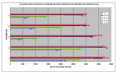
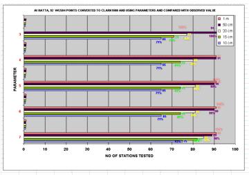
5 Coon Points on / Clark 880 Spheroid Transforation Coputation Residuals Table For 966 Coon Points - Mainland Transforation Coputation Residuals Table For 88 Coon Points at 3744 Points Converted to Clark 880, Using Paraeters and Copared With Observed Value Mainland 3744 Points Converted to Clark 880, Using Paraeters and Copared With Observed Value 9 Points Converted to Clark880, Using Paraeters & Copared With Observed Value Mainland 5


 Mainland Main Land")


6 Accuracy after Transforation using the Transforation Paraeters Statistical Quantities for 7 Paraeters (Molodesky-Badekas & Bursa-Wolf) Mainland Main Land Statistical Quantities for 7 Paraeters (Molodesky-Badekas & Bursa-Wolf 7 Transforation Paraeters 7 Transforation Paraeters Transforation Progra Flow Chart 6


7 Transforation progra Main enu Transforation progra Paraeter Menu Paraeters for Transforation fro WGS 84 To DLTM Transforation progra Out put and File option enu DLTM Dubai Local Transverse Mercator Conclusion The optial transforation paraeter sets coputed for ain land and Dubai The full Seven paraeters set is recoended using Molodensky Badekas odel For any ellipsoidal points a conversion can be carried out up to 0 c precision, where as for any Clark880 points conversion precision between 0 50 c 7
Spatial Reference Systems. Introduction
 Spatial Reference Systems Wolfgang Kainz Professor of Cartography and Geoinformation Department of Geography and Regional Research University of Vienna wolfgang.kainz@univie.ac.at Introduction Historic
When the Earth Was Flat. Measurements were made using a plumb bob, a spirit level, and a stick. Also, the Stars.
 ABSTRACT Defining the shape of the Earth geoid. Mathematical models spheroid or ellipsoid Mathematical projection of geodetic systems GIS/GPS technology The need for a unified projection systems World
GPS Remote Sensing. GIS Photogrammetry. GEODESY Equipment (total station) CARTOGRAPHY Survey Software. Map Projection Coordinate Systems
 CARTOGRAPHY Survey Software. Map Projection Coordinate Systems") GPS Remote Sensing GIS Photogrammetry GEODESY Equipment (total station) CARTOGRAPHY Survey Software Map Projection Coordinate Systems 1 Coordinate Systems, Datum and Map Projection Dr. Maher A. El-Hallaq
GPS Remote Sensing GIS Photogrammetry GEODESY Equipment (total station) CARTOGRAPHY Survey Software Map Projection Coordinate Systems 1 Coordinate Systems, Datum and Map Projection Dr. Maher A. El-Hallaq
Outline. Shape of the Earth. Geographic Coordinates (φ, λ, z) Ellipsoid or Spheroid Rotate an ellipse around an axis. Ellipse.
 Ellipsoid or Spheroid Rotate an ellipse around an axis. Ellipse.") Map Projections Outline Geodesy and map projections Prof. D. Nagesh Kumar Department of Civil Engineering Indian Institute of Science Bangalore 560 012, India http://www.civil.iisc.ernet.in/~nagesh Shape
Map Projections Outline Geodesy and map projections Prof. D. Nagesh Kumar Department of Civil Engineering Indian Institute of Science Bangalore 560 012, India http://www.civil.iisc.ernet.in/~nagesh Shape
Map projections. Rüdiger Gens
 Rüdiger Gens Coordinate systems Geographic coordinates f a: semi-major axis b: semi-minor axis Geographic latitude b Geodetic latitude a f: flattening = (a-b)/a Expresses as a fraction 1/f = about 300
Lecture 4. Coordinate Systems & Projections
 Lecture 4 Coordinate Systems & Projections Outline Geodesy Geoids Ellipsoids Geographic Coordinate Systems Magnetic North vs. True North Datums Projections Applying Coordinate Systems and Projections Why
Modern Navigation. Thomas Herring
 12.215 Modern Navigation Thomas Herring Today s Class Latitude and Longitude Simple spherical definitions Geodetic definition: For an ellipsoid Astronomical definition: Based on direction of gravity Relationships
Coordinate Systems. Location on earth is defined by coordinates
 Coordinate Systems We think of the earth as a sphere It is actually a spheroid (ellipsoid), slightly larger in radius at the equator than at the poles Shape of the Earth Location on earth is defined by
Understanding Projections for GIS
 Presented by John Schaeffer Juniper GIS Services, Inc. This PowerPoint is available at JuniperGIS.com Presentation Objectives To understand basic concepts on projections and coordinate systems for the
Mapping coordinate systems
 Mapping coordinate systems 1. The Earth's Graticule Latitude and Longitude The graticule is the imaginary grid of lines running east-west (lines of latitude = parallels) and north-south lines of longitude
What is a Map Projection?
 What is a Map Projection? It is how we represent a three dimensional Earth on a flat piece of paper However The process of transferring information from the Earth to a map causes every projection to distort
Shape e o f f the e Earth
 1 Coordinate Systems & Projections Coordinate Systems Two map layers are not going to register spatially unless they are based on the same coordinate system. 2 Contents Shape of the earth Datum Projections
Georeferencing. Where on earth are we? Critical for importing and combining layers for mapping
 Georeferencing Where on earth are we? Critical for importing and combining layers for mapping 1. The Geoid Earth is not a perfect sphere, it is ellipsoidal.. earth is the 'Geoid'. The difference between
Geo Referencing & Map projections CGI-GIRS 0910
 Geo Referencing & Map projections CGI-GIRS 0910 Where are you? 31UFT8361 174,7 441,2 51 58' NB 5 40' OL 2/60 Who are they? 3/60 Do geo data describe Earth s phenomena perfectly? Georeference systems ellipsoid
What is Geodesy? Types of Geodesy terrestrial or classical geodesy space geodesy theoretical geodesy
 What is Geodesy? Geodesy is the study of: The size, shape and motion of the earth The measurement of the position and motion of points on the earth's surface, and The study of the earth's gravity field
1/28/16. EGM101 Skills Toolbox. Oblate spheroid. The shape of the earth Co-ordinate systems Map projections. Geoid
 EGM101 Skills Toolbox Oblate spheroid The shape of the earth Co-ordinate systems Map projections The geoid is the shape that the surface of the oceans would take under the influence of Earth's gravitation
Introduction to Geographic Information Science. Updates/News. Last Lecture. Geography 4103 / Map Projections and Coordinate Systems
 Geography 4103 / 5103 Introduction to Geographic Information Science Map Projections and Coordinate Systems Updates/News Thursday s lecture Reading discussion 1 find the readings online open questions,
12/26/2012. Geographic Information Systems * * * * GIS (... yrezaei
 ( - Geographic Information Systems ( ( 1 2 3 Information System Data base DB IS IS DB (Knowledge ( ( (System (Information System - (Georefrence Analysis Data + Knowledge ======== Information 4 5 ( < 10%
NR402 GIS Applications in Natural Resources Lesson 4 Map Projections
 NR402 GIS Applications in Natural Resources Lesson 4 Map Projections From http://www.or.blm.gov/gis/ 1 Geographic coordinates Coordinates are expressed as Latitude and Longitude in Degrees, Minutes, Seconds
How does an ellipsoid differ from a sphere in approximating the shape and size of the Earth?
 Chapter 02 Test Bank Worksheet Questions 1. What is a map projection? Topic: Map Projection 2. How does an ellipsoid differ from a sphere in approximating the shape and size of the Earth? Topic: Ellipsoid
Georeferencing, Map Projections, Cartographic Concepts. -Coordinate Systems -Datum
 Georeferencing, Map Projections, Cartographic Concepts -Map Projections -Coordinate Systems -Datum Map projection is "the process of systematically transforming positions on the Earth's spherical surface
Geographic coordinate systems
 1 Geographic coordinate systems In this chapter you ll learn about longitude and latitude. You ll also learn about the parts that comprise a geographic coordinate system including Spheres and spheroids
Lesson 5: Map Scale and Projections
 Organizing Data and Information Lesson 5: Map Scale and Projections Map Scales Projections Information can be organized as lists, numbers, tables, text, pictures, maps, or indexes. Clusters of information
Geo Referencing & Map projections CGI-GIRS 0910
 Geo Referencing & Map projections CGI-GIRS 0910 Where are you? 31UFT8361 174,7 441,2 51 58' NB 5 40' OL 2/60 Who are they? 3/60 Do geo data describe Earth s phenomena perfectly? Georeference systems ellipsoid
This week s topics. Week 6. FE 257. GIS and Forest Engineering Applications. Week 6
 FE 257. GIS and Forest Engineering Applications Week 6 Week 6 Last week Chapter 8 Combining and splitting landscape features and merging GIS databases Chapter 11 Overlay processes Questions? Next week
Spine Fin Efficiency A Three Sided Pyramidal Fin of Equilateral Triangular Cross-Sectional Area
 Proceedings of the 006 WSEAS/IASME International Conference on Heat and Mass Transfer, Miai, Florida, USA, January 18-0, 006 (pp13-18) Spine Fin Efficiency A Three Sided Pyraidal Fin of Equilateral Triangular
EnvSci360 Computer and Analytical Cartography
 EnvSci360 Computer and Analytical Cartography Lecture 3 Geodesy Map Projections, Datums, and Coordinate Systems 1 Geodesy The science of measuring and representing the shape and size of the earth, and
The Elements of GIS. Organizing Data and Information. The GIS Database. MAP and ATRIBUTE INFORMATION
 GIS s Roots in Cartography Getting Started With GIS Chapter 2 Dursun Z. Seker MAP and ATRIBUTE INFORMATION Data (numbers and text) store as files refer to them collectively as a database gather inform.
Intelligent Systems: Reasoning and Recognition. Perceptrons and Support Vector Machines
 Intelligent Systes: Reasoning and Recognition Jaes L. Crowley osig 1 Winter Seester 2018 Lesson 6 27 February 2018 Outline Perceptrons and Support Vector achines Notation...2 Linear odels...3 Lines, Planes
Reference Systems. Paolo Zatelli - Alfonso Vitti. Dept. Civil and Environmental Engineering University of Trento
 Reference Systems Reference Systems Paolo Zatelli - Alfonso Vitti Dept. Civil and Environmental Engineering University of Trento P. Zatelli - A. Vitti University of Trento - Italy 1 / 34 Reference Systems
Model Fitting. CURM Background Material, Fall 2014 Dr. Doreen De Leon
 Model Fitting CURM Background Material, Fall 014 Dr. Doreen De Leon 1 Introduction Given a set of data points, we often want to fit a selected odel or type to the data (e.g., we suspect an exponential
WHERE ARE YOU? Maps & Geospatial Concepts Fall 2012
 WHERE ARE YOU? Maps & Geospatial Concepts Fall 2012 Where are you? Relative location I m at school Absolute Location 45 26 18.07 122 43 50.78 Datums Datums A reference surface of the Earth Used as the
Intro to GIS Fall 2010 Georeferencing & Map Projections
 Intro to GIS Fall 2010 Georeferencing & Map Projections SHAPE OF THE EARTH Earth's Shape Geoid: shape of earth minus topographic features (irregular due to local variations in gravity) Ellipsoid: elongated
Georeferencing. Place names Postal addresses Postal codes Coordinate systems (lat/long, UTM, etc.)
") Georeferencing Georeferencing Used to describe the act of assigning locations to data or information Certain requirements include that they are: unique, have shared meaning, and are persistent through
Georeferencing Georeferencing Used to describe the act of assigning locations to data or information Certain requirements include that they are: unique, have shared meaning, and are persistent through
Experimental Design For Model Discrimination And Precise Parameter Estimation In WDS Analysis
 City University of New York (CUNY) CUNY Acadeic Works International Conference on Hydroinforatics 8-1-2014 Experiental Design For Model Discriination And Precise Paraeter Estiation In WDS Analysis Giovanna
Introduction to Cartography GEOG 2016 E. Lecture-2 Geodesy and Projections
 Introduction to Cartography GEOG 2016 E Lecture-2 Geodesy and Projections What is Geodesy? The science of geodesy determines: Earth s shape and Interrelation of different points on earth s surface The
Proc. of the IEEE/OES Seventh Working Conference on Current Measurement Technology UNCERTAINTIES IN SEASONDE CURRENT VELOCITIES
 Proc. of the IEEE/OES Seventh Working Conference on Current Measureent Technology UNCERTAINTIES IN SEASONDE CURRENT VELOCITIES Belinda Lipa Codar Ocean Sensors 15 La Sandra Way, Portola Valley, CA 98 blipa@pogo.co
Geocentric Datum of Australia - GDA
 Geocentric Datum of Australia - GDA Supporting GDA94 ARC/INFO 7.2.1 ArcView 3.1 An ESRI Australia White Paper September 1999 White Paper Series OVERVIEW... 1 INTRODUCTION... 1 PART 1 ESRI SOLUTION... 2
1. Geospatial technology rarely links geospatial data to nonspatial data. a. True *b. False
 Chapter 2 Where in the Geospatial World Are You? 1. Geospatial technology rarely links geospatial data to nonspatial data. 2. For geospatial technology to work, every location on Earth must be: a. inhabited
Data acquisition and integration 1.
 Data acquisition and integration 1. Ferenc Végső Data acquisition and integration 1.: Ferenc Végső Lector: Árpád Barsi This module was created within TÁMOP - 4.1.2-08/1/A-2009-0027 "Tananyagfejlesztéssel
Non-Parametric Non-Line-of-Sight Identification 1
 Non-Paraetric Non-Line-of-Sight Identification Sinan Gezici, Hisashi Kobayashi and H. Vincent Poor Departent of Electrical Engineering School of Engineering and Applied Science Princeton University, Princeton,
Pattern Recognition and Machine Learning. Learning and Evaluation for Pattern Recognition
 Pattern Recognition and Machine Learning Jaes L. Crowley ENSIMAG 3 - MMIS Fall Seester 2017 Lesson 1 4 October 2017 Outline Learning and Evaluation for Pattern Recognition Notation...2 1. The Pattern Recognition
WHERE ARE YOU? Maps & Geospatial Concepts Fall 2015
 WHERE ARE YOU? Maps & Geospatial Concepts Fall 2015 Where are you? Relative location I m at school Absolute Location 45 26 18.07 122 43 50.78 Where is Boston? Introducing Geodesy, Ellipsoids & Geoids Geodesy
NAVIPAC 4 GEODETIC CONTROL
 NAVIPAC 4 GEODETIC CONTROL Contents 1 Introduction... 4 2 Projections... 5 2.1 Projections in general... 6 2.2 Specific projections... 7 2.2.1 Transverse Mercator... 7 2.2.2 Universal Transverse Mercator...
start of Swedish national maps.
 1809 - start of Swedish national maps. Corps of military field measurement Triangulation network Spheroid: Bessel 1841 Semimajor axis: : 6377397.155 Semiminor axis: : 6356078.963 Inverse flattening: :
Data acquisition and integration 1.
 University of West Hungary, Faculty of Geoinformatics Ferenc Végső Data acquisition and integration 1. module DAI1 The basics of positioning SZÉKESFEHÉRVÁR 2010 The right to this intellectual property
REFERENCING COORDINATE SYSTEMS MAP PROJECTIONS GEOREFERENCING
 GIS in Ecology SPATIAL REFERENCING COORDINATE SYSTEMS MAP PROJECTIONS GEOREFERENCING : :1 Where on earth? Early mapmakers recognized the need for a system that could locate features on the earth's surface.
Geodetic System Technical Report GS 1997/11
 Geodetic Sste Technical Report GS 1997/11 Docuent nae Recoended transforation paraeters fro WGS84 to NZGD49 Original uthor Merrin Pearse and Chris Crook Client Surveor General Distribution Unrestricted
Welcome to Lesson 4. It is important for a GIS analyst to have a thorough understanding of map projections and coordinate systems.
 Welcome to Lesson 4. It is important for a GIS analyst to have a thorough understanding of map projections and coordinate systems. A GIS without coordinates would simply be a database like Microsoft Excel
Chaotic Coupled Map Lattices
 Chaotic Coupled Map Lattices Author: Dustin Keys Advisors: Dr. Robert Indik, Dr. Kevin Lin 1 Introduction When a syste of chaotic aps is coupled in a way that allows the to share inforation about each
Lecture 10-14: Map Projections and Coordinate System
 URP 1281 Surveying and Cartography Lecture 10-14: Map Projections and Coordinate System December 27, 2015 Course Teacher: Md. Esraz-Ul-Zannat Assistant Professor Department of Urban and Regional Planning
GIST 3300 / Geographic Information Systems. Last Time. Today
 GIST 3300 / 5300 Last Time Ellipsoids and Datums Today Map Projections Map Projections Today we will build on the concepts of Geographic Coordinate Systems, Ellipsoids and Datums and add the concepts of
This presentation covers the following areas
 Geodetic Datums and Coordinate Systems for Surveying and Mapping in Hong Kong FIG Working Week 2012 Rome, Italy 6-10 May Simon KWOK Hong Kong, China 1 This presentation covers the following areas Explains
Control Surveys and Coordinate Systems
 Control Surveys and Coordinate Systems The Earth is Round Basic Shape of the Earth: Oblate Spheroid of Revolution The length of the equatorial axis is approximately 27 miles greater than the polar axis.
2. GETTING STARTED WITH GIS
 2. GETTING STARTED WITH GIS What are geographic information systems and what are they used for? ArcGIS: ArcMap, ArcCatalog and ArcToolbox Vector data vs. raster data vs. attribute tables Polygons, polylines,
3D acoustic wave modeling with a time-space domain dispersion-relation-based Finite-difference scheme
 P-8 3D acoustic wave odeling with a tie-space doain dispersion-relation-based Finite-difference schee Yang Liu * and rinal K. Sen State Key Laboratory of Petroleu Resource and Prospecting (China University
GEOMATICS ENGINEERING / SURVEYING
 1 GEOMATICS ENGINEERING / SURVEYING CHAPTER 1 Dr. Muhammad Ashraf Javid Assistant Professor Department of Civil and Environmental Engineering Email: muhammad.javid@unizwa.edu.om 2 Geomatics Engineering
ch02.pdf chap2.pdf chap02.pdf
 Introduction to Geographic Information Systems 8th Edition Karl Solutions Manual Full Download: http://testbanklive.com/download/introduction-to-geographic-information-systems-8th-edition-karl-solutions-manu
A PRIMER ON COORDINATE SYSTEMS Commonly Used in Michigan
 A PRIMER ON COORDINATE SYSTEMS Commonly Used in Michigan David P. Lusch, Ph.D., GISP Department of Geography Remote Sensing & GIS Research and Outreach Services Group Michigan State University September,
The Wildlife Society Meet and Greet. Come learn about what the UNBC Student Chapter of TWS is all about!
 Georeferencing I GEOG 300, Lecture 4 Dr. Anthony Jjumba 1 The Wildlife Society Meet and Greet Quiz Come learn about what the UNBC Student Chapter of TWS is all about! 5:30 7:30 PM, Wednesday September
DERIVING PROPER UNIFORM PRIORS FOR REGRESSION COEFFICIENTS
 DERIVING PROPER UNIFORM PRIORS FOR REGRESSION COEFFICIENTS N. van Erp and P. van Gelder Structural Hydraulic and Probabilistic Design, TU Delft Delft, The Netherlands Abstract. In probles of odel coparison
Lecture 2. Map Projections and GIS Coordinate Systems. Tomislav Sapic GIS Technologist Faculty of Natural Resources Management Lakehead University
 Lecture 2 Map Projections and GIS Coordinate Systems Tomislav Sapic GIS Technologist Faculty of Natural Resources Management Lakehead University Map Projections Map projections are mathematical formulas
About the definition of parameters and regimes of active two-port networks with variable loads on the basis of projective geometry
 About the definition of paraeters and regies of active two-port networks with variable loads on the basis of projective geoetry PENN ALEXANDR nstitute of Electronic Engineering and Nanotechnologies "D
Block designs and statistics
 Bloc designs and statistics Notes for Math 447 May 3, 2011 The ain paraeters of a bloc design are nuber of varieties v, bloc size, nuber of blocs b. A design is built on a set of v eleents. Each eleent
COS 424: Interacting with Data. Written Exercises
 COS 424: Interacting with Data Hoework #4 Spring 2007 Regression Due: Wednesday, April 18 Written Exercises See the course website for iportant inforation about collaboration and late policies, as well
Mobile Mapping Tips and Tricks
 Mobile Mapping Tips and Tricks Projections, Datums and Geoids, May 2017 Introduction This guide is designed to provide a basic understanding of coordinate system projections, datums and geoids. The guide
Dr. ABOLGHASEM AKBARI Faculty of Civil Engineering & Earth Resources, University Malaysia Pahang (UMP)
") Workshop on : Dr. ABOLGHASEM AKBARI Faculty of Civil Engineering & Earth Resources, University Malaysia Pahang (UMP) 14-15 April 2016 Venue: Tehran, Iran GIS definitions GIS: A simplified view of the real
Workshop on : Dr. ABOLGHASEM AKBARI Faculty of Civil Engineering & Earth Resources, University Malaysia Pahang (UMP) 14-15 April 2016 Venue: Tehran, Iran GIS definitions GIS: A simplified view of the real
Solving the "Grid to Ground Problem" with Custom Coordinate Systems CV327-6 About the Speaker:
 Solving the "Grid to Ground Problem" with Custom Coordinate Systems Richard Sincovec, LSI Director of Technology, Edward James Surveying President, Quux Software CV327-6 Grid projections such as the State
HP-35s Calculator Program TM 1
 Convert Latitude and Longitude to Transverse Mercator Co-ordinates (UTM, SPCS, etc.) Programmer: Dr. Bill Hazelton Date: April, 2008. Version: 1.0 Mnemonic: T for Transverse Mercator Line Instruction Display
This model assumes that the probability of a gap has size i is proportional to 1/i. i.e., i log m e. j=1. E[gap size] = i P r(i) = N f t.
![This model assumes that the probability of a gap has size i is proportional to 1/i. i.e., i log m e. j=1. E[gap size] = i P r(i) = N f t.](/thumbs/73/69472191.jpg "This model assumes that the probability of a gap has size i is proportional to 1/i. i.e., i log m e. j=1. E[gap size] = i P r(i) = N f t.") CS 493: Algoriths for Massive Data Sets Feb 2, 2002 Local Models, Bloo Filter Scribe: Qin Lv Local Models In global odels, every inverted file entry is copressed with the sae odel. This work wells when
CS 493: Algoriths for Massive Data Sets Feb 2, 2002 Local Models, Bloo Filter Scribe: Qin Lv Local Models In global odels, every inverted file entry is copressed with the sae odel. This work wells when
HP-33S Calculator Program TM 2
 Convert Latitude and Longitude to Transverse Mercator Co-ordinates (UTM, SPCS, etc.) Programmer: Dr. Bill Hazelton Date: April, 2008. Version: 1.0 Mnemonic: T for Transverse Mercator Line Instruction Display
Chapter 6 1-D Continuous Groups
 Chapter 6 1-D Continuous Groups Continuous groups consist of group eleents labelled by one or ore continuous variables, say a 1, a 2,, a r, where each variable has a well- defined range. This chapter explores:
Projections & GIS Data Collection: An Overview
 Projections & GIS Data Collection: An Overview Projections Primary data capture Secondary data capture Data transfer Capturing attribute data Managing a data capture project Geodesy Basics for Geospatial
Kernel Methods and Support Vector Machines
 Intelligent Systes: Reasoning and Recognition Jaes L. Crowley ENSIAG 2 / osig 1 Second Seester 2012/2013 Lesson 20 2 ay 2013 Kernel ethods and Support Vector achines Contents Kernel Functions...2 Quadratic
ACTIVE VIBRATION CONTROL FOR STRUCTURE HAVING NON- LINEAR BEHAVIOR UNDER EARTHQUAKE EXCITATION
 International onference on Earthquae Engineering and Disaster itigation, Jaarta, April 14-15, 8 ATIVE VIBRATION ONTROL FOR TRUTURE HAVING NON- LINEAR BEHAVIOR UNDER EARTHQUAE EXITATION Herlien D. etio
Design of 25 KA Current Injection Transformer Core with Finite Element Method
 1 Design of 5 KA Current Injection Transforer Core ith Finite Eleent Method HOSSEIN HEYDARI, MOHSEN ARIANNEJAD, FARAMARZ FAGHIHI Iran University of Science and Technology, Tehran, Iran Abstract.Since Current
GEOGRAPHIC COORDINATE SYSTEMS
 GEOGRAPHIC COORDINATE SYSTEMS Introduction to GIS Winter 2015 What is Georeferencing? Used to establish a location on the Earth s surface 1 st order polynomial transformation Georeferencing toolbar What
Designing for the Road User. Maximum Spiral Transition Lengths
 IPENZ Transportation Conference 11 October 2006 Queenstown, New Zealand Designing for the Road User Maxiu Spiral Transition Lengths K H M Weale Northern Region Technical Developent Leader MWH New Zealand
Reference Coordinate Systems (3/3)
") Reference Coordinate Systems (3/3) José E. Sanguino I Instituto de elecomunicações Instituto Superior écnico, v. Rovisco Pais, 049-00 Lisboa, Portugal el: +35.848468, Fax: +35.84847, Email: sanguino@lx.it.pt
Reference Coordinate Systems (3/3) José E. Sanguino I Instituto de elecomunicações Instituto Superior écnico, v. Rovisco Pais, 049-00 Lisboa, Portugal el: +35.848468, Fax: +35.84847, Email: sanguino@lx.it.pt
Inspection; structural health monitoring; reliability; Bayesian analysis; updating; decision analysis; value of information
 Cite as: Straub D. (2014). Value of inforation analysis with structural reliability ethods. Structural Safety, 49: 75-86. Value of Inforation Analysis with Structural Reliability Methods Daniel Straub
Boolean Operators and Topological OVERLAY FUNCTIONS IN GIS
 Boolean Operators and Topological OVERLAY FUNCTIONS IN GIS Query asking a question of the attribute data Standard Query Language (SQL) is used to query the data There are 4 basic statements used to get
Supplementary Information for Design of Bending Multi-Layer Electroactive Polymer Actuators
 Suppleentary Inforation for Design of Bending Multi-Layer Electroactive Polyer Actuators Bavani Balakrisnan, Alek Nacev, and Elisabeth Sela University of Maryland, College Park, Maryland 074 1 Analytical
Ensemble Based on Data Envelopment Analysis
 Enseble Based on Data Envelopent Analysis So Young Sohn & Hong Choi Departent of Coputer Science & Industrial Systes Engineering, Yonsei University, Seoul, Korea Tel) 82-2-223-404, Fax) 82-2- 364-7807
Modeling the Structural Shifts in Real Exchange Rate with Cubic Spline Regression (CSR). Turkey
. Turkey") International Journal of Business and Social Science Vol. 2 No. 17 www.ijbssnet.co Modeling the Structural Shifts in Real Exchange Rate with Cubic Spline Regression (CSR). Turkey 1987-2008 Dr. Bahar BERBEROĞLU
International Journal of Business and Social Science Vol. 2 No. 17 www.ijbssnet.co Modeling the Structural Shifts in Real Exchange Rate with Cubic Spline Regression (CSR). Turkey 1987-2008 Dr. Bahar BERBEROĞLU
Introduction to Robotics (CS223A) (Winter 2006/2007) Homework #5 solutions
 (Winter 2006/2007) Homework #5 solutions") Introduction to Robotics (CS3A) Handout (Winter 6/7) Hoework #5 solutions. (a) Derive a forula that transfors an inertia tensor given in soe frae {C} into a new frae {A}. The frae {A} can differ fro frae
Introduction to Robotics (CS3A) Handout (Winter 6/7) Hoework #5 solutions. (a) Derive a forula that transfors an inertia tensor given in soe frae {C} into a new frae {A}. The frae {A} can differ fro frae
Research in Area of Longevity of Sylphon Scraies
 IOP Conference Series: Earth and Environental Science PAPER OPEN ACCESS Research in Area of Longevity of Sylphon Scraies To cite this article: Natalia Y Golovina and Svetlana Y Krivosheeva 2018 IOP Conf.
Map Projections. Displaying the earth on 2 dimensional maps
 Map Projections Displaying the earth on 2 dimensional maps Map projections Define the spatial relationship between locations on earth and their relative locations on a flat map Are mathematical expressions
A NEW ROBUST AND EFFICIENT ESTIMATOR FOR ILL-CONDITIONED LINEAR INVERSE PROBLEMS WITH OUTLIERS
 A NEW ROBUST AND EFFICIENT ESTIMATOR FOR ILL-CONDITIONED LINEAR INVERSE PROBLEMS WITH OUTLIERS Marta Martinez-Caara 1, Michael Mua 2, Abdelhak M. Zoubir 2, Martin Vetterli 1 1 School of Coputer and Counication
Map Projections. What does the world look like? AITOFF AZIMUTHAL EQUIDISTANT BEHRMANN EQUAL AREA CYLINDRICAL
 Map Projections What does the world look like? AITOFF AZIMUTHAL EQUIDISTANT BEHRMANN EQUAL AREA CYLINDRICAL 1 CYLINDRICAL EQUAL AREA BONNE CRASTER PARABOLIC 2 ECKERT I ECKERT III ECKERT V There are many
Geographers Perspectives on the World
 What is Geography? Geography is not just about city and country names Geography is not just about population and growth Geography is not just about rivers and mountains Geography is a broad field that
UNITED NATIONS E/CONF.97/6/IP. 33
 UNITED NATIONS E/CONF.97/6/IP. 33 ECONOMIC AND SOCIAL COUNCIL Seventeenth United Nations Regional Cartographic Conference for Asia and the Pacific Bangkok, 18-22 September 2006 Item 7 of the provisional
Importance of Understanding Coordinate Systems and Map Projections.
 Importance of Understanding Coordinate Systems and Map Projections. 1 It is extremely important that you gain an understanding of coordinate systems and map projections. GIS works with spatial data, and,
Support Vector Machine Classification of Uncertain and Imbalanced data using Robust Optimization
 Recent Researches in Coputer Science Support Vector Machine Classification of Uncertain and Ibalanced data using Robust Optiization RAGHAV PAT, THEODORE B. TRAFALIS, KASH BARKER School of Industrial Engineering
Reservoirs to Regions
 Reservoirs to Regions A Geodetic Approach to Scalable Visualization without Distortion Noel Zinn Geodetics and Cartography ExxonMobil Exploration Company Version 3 / 12 July 25 Reservoirs to Regions v3
Forecasting Financial Indices: The Baltic Dry Indices
 International Journal of Maritie, Trade & Econoic Issues pp. 109-130 Volue I, Issue (1), 2013 Forecasting Financial Indices: The Baltic Dry Indices Eleftherios I. Thalassinos 1, Mike P. Hanias 2, Panayiotis
The Gauss Conform Coordinate
 Surveying The South African Coordinate Reference System (Part 2) by Aslam Parker, Chief Directorate: National Geo-spatial Information Part 1 of this article (see PositionIT Nov/Dec 2011) focused on the
THE EVOLUTION OF MATHEMATICAL BASES OF POLISH TOPOGRAPHIC MAPS DURING THE RECENT 80 YEARS
 Michal Stankiewicz is a lecturer in map redaction, topography and topographic cartography in Department of Geodesy and Cartography, Warsaw University of Technology. In 1979 he obtained the degree of Doctor
Overview key concepts and terms (based on the textbook Chang 2006 and the practical manual)
") Introduction Geo-information Science (GRS-10306) Overview key concepts and terms (based on the textbook 2006 and the practical manual) Introduction Chapter 1 Geographic information system (GIS) Geographically
Introduction Geo-information Science (GRS-10306) Overview key concepts and terms (based on the textbook 2006 and the practical manual) Introduction Chapter 1 Geographic information system (GIS) Geographically
GPS Surveying Dr. Jayanta Kumar Ghosh Department of Civil Engineering Indian Institute of Technology, Roorkee. Lecture 06 GPS Position
 GPS Surveying Dr. Jayanta Kumar Ghosh Department of Civil Engineering Indian Institute of Technology, Roorkee Lecture 06 GPS Position Friends! Welcome you to sixth class on GPS surveying. Today, I am going
Height systems. Rudi Gens Alaska Satellite Facility
 Rudi Gens Alaska Satellite Facility Outline Why bother about height systems? Relevant terms Coordinate systems Reference surfaces Geopotential number 2 Why bother about height systems? give a meaning to