Copyri g h t 2012 OSIso f t, LLC. 1
|
|
|
- Vivien Chandler
- 6 years ago
- Views:
Transcription

1 Copyri g h t 2012 OSIso f t, LLC. 1

2 The Power of Data Presented by Ted Gorrie Copyri g h t 2012 OSIso f t, LLC.

3 Copyri g h t 2012 OSIso f t, LLC. 3

4 It is a very sad thing that nowadays there is so little useless information. Oscar Wilde From A Few Maxims For The Instruction Of The Over-Educated Copyri g h t 2012 OSIso f t, LLC. 4
5 Every day I wake up and ask, how can I flow data better, manage data better, analyze data better? Rollin Ford, CIO Wal-Mart Copyri g h t 2012 OSIso f t, LLC. 5


6 Copyri g h t 2012 OSIso f t, LLC. 6


7 New York Stock Exchange Copyri g h t 2012 OSIso f t, LLC. 7

8 VISA: 300 Million Transactions / Day Copyri g h t 2012 OSIso f t, LLC. 8

9 Copyri g h t 2012 OSIso f t, LLC. 9


10 Copyri g h t 2012 OSIso f t, LLC. 10


11 Copyri g h t 2012 OSIso f t, LLC. 11
12 Copyri g h t 2012 OSIso f t, LLC. 12


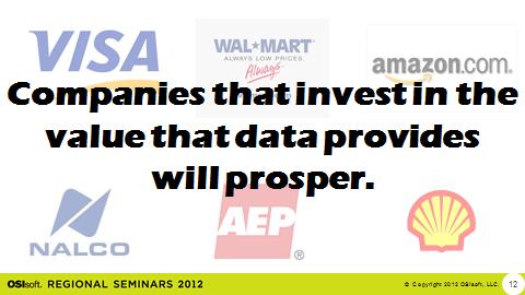
13 Companies that invest in the value that data provides will prosper. Copyri g h t 2012 OSIso f t, LLC. 13


14 80.0% 60.0% US Core Web Search Market Share - Aug % 40.0% 20.0% 15.1% 19.2% 0.0% 0.0% 0.0% 0.0% 0.0% 0.8% Lycos Yahoo! Ask Excite AltaVista Google Bing AOL Search Search Company (Year Started) Copyri g h t 2012 OSIso f t, LLC. 14

 Technology: Map-Reduce")
15 Google Why did they beat the earlier contenders? Recognized there was more data than meets the eye (clicks) Technology: Map-Reduce Copyri g h t 2012 OSIso f t, LLC. 15
 Copyri g h t 2012 OSIso f t, LLC.")
16 Early to Mid-1980s: started out in Advanced Control Technology: Advanced Control Recognized there was more data than meets the eye (historize the real-time data) Copyri g h t 2012 OSIso f t, LLC. 16


17 Infrastructure is the most efficient way to deliver services needed by many Copyri g h t 2012 OSIso f t, LLC. 17
18 Companies that invest in the How do we overcome the opportunities that data data challenges? provides will prosper. Copyri g h t 2012 OSIso f t, LLC. 18


19 Copyri g h t 2012 OSIso f t, LLC. 19


 2 0 2010 2011")


20 Big Data World s Information Today ~18% Cloud bytes (1 billion TB) Source: Copyri g h t 2012 OSIso f t, LLC. 20
 Copyri g h t 2012 OSIso f t, LLC.")
21 PI SERVER 2012 (SCALABILITY: 20+ MILLION PI TAGS) Copyri g h t 2012 OSIso f t, LLC. 21

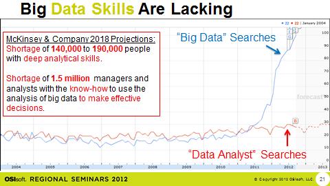
22 Big Data Skills Are Lacking McKinsey & Company 2018 Projections: Shortage of 140,000 to 190,000 people with deep analytical skills. Big Data Searches Shortage of 1.5 million managers and analysts with the know-how to use the analysis of big data to make effective decisions. Data Analyst Searches Copyri g h t 2012 OSIso f t, LLC. 22


23 Addressing the Data Skills Shortage Copyri g h t 2012 OSIso f t, LLC. 23

24 Information Overload? Copyri g h t 2012 OSIso f t, LLC. 24

25 Information Overload? Copyri g h t 2012 OSIso f t, LLC. 25

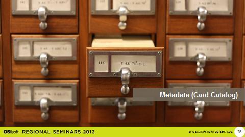
26 Metadata (Card Catalog) Copyri g h t 2012 OSIso f t, LLC. 26

27 Metadata (PI AF) Copyri g h t 2012 OSIso f t, LLC. 27
28 Metadata (Card Catalog) Copyri g h t 2012 OSIso f t, LLC. 28

29 Metadata (PI AF) PI AF: A Complete Picture of Your Asset Real-time Values Inlet pressure Inlet flow Ambient temperature Real-time Values Exhaust temperature Exhaust flow Measured MW output Asset Details Name Make Model Notifications Performance excursions Temperature difference High temperature External Databases Performance curves Last service date Design documents Inspection best practice Calculations Performance calculations KPI s Business Events Downtime Startups Shutdowns Excursions Copyri g h t 2012 OSIso f t, LLC.

30 Trust the Data 1 in 3 business leaders don t trust the information they use to make decisions. IBM Copyri g h t 2012 OSIso f t, LLC. 30

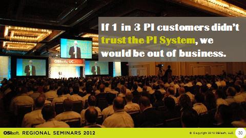
31 If 1 in 3 PI customers didn t trust the PI System, we would be out of business. Copyri g h t 2012 OSIso f t, LLC. 31
32 What are the keys to realizing & unlocking the power of data? Copyri g h t 2012 OSIso f t, LLC. 32

33 Peter Drucker, The Practice of Management The important and difficult job is never to find the right answers, it is to find the right question. Copyri g h t 2012 OSIso f t, LLC. 34

34 The formulation of a problem is often more important than its solution. Albert Einstein Copyri g h t 2012 OSIso f t, LLC. 35
35 It [Big Data] has great potential for good as long as consumers, companies and governments make the right choices about when to restrict the flow of data, and when to encourage it. The data deluge, Feb 25, 2010 The Economist ALL the DATA Copyri g h t 2012 OSIso f t, LLC. 37

36 Technology & Skills Copyri g h t 2012 OSIso f t, LLC. 38


37 Microsoft Business Intelligence PowerPivot Power View Copyri g h t 2012 OSIso f t, LLC. 39


38 OSIsoft: Project Rubik Goal: Integrate PI System Data with Microsoft BI Bridge the Gap Auto-build BI models Proper data aggregation Copyri g h t 2012 OSIso f t, LLC. 40


39 Curiosity Ingenuity Discovery Insight Discovery Copyri g h t 2012 OSIso f t, LLC. 41


40 Copyri g h t 2012 OSIso f t, LLC. 42


41 find the right question Discover ALL the Insight the POWER of DATA Ingenuity Curiosity apply technology & skills Copyri g h t 2012 OSIso f t, LLC. 43

42 Brought to you by 45 Copyri g h t 2012 OSIso f t, LLC.
Insightful Reporting with the Presented by Todd Brown, Chris Nelson. Copyri g h t 2012 OSIso f t, LLC.
 Insightful Reporting with the PI System Presented by Todd Brown, Chris Nelson Copyri g h t 2012 OSIso f t, LLC. Copyri g h t 2012 OSIso f t, LLC. 2 Reporting In the Beginning Copyri g h t 2012 OSIso f
PI Event Frames Moving Forward with Data Access and Client Support. Copyri g h t 2012 OSIso f t, LLC.
 PI Event Frames Moving Forward with Data Access and Client Support Presented by Todd Brown, Chris Nelson Copyri g h t 2012 OSIso f t, LLC. Copyri g h t 2012 OSIso f t, LLC. 2 The Power of Data. Big Data.
PI SERVER 2012 Do. More. Faster. Now! Copyr i g h t 2012 O S Is o f t, L L C. 1
 PI SERVER 2012 Do. More. Faster. Now! Copyr i g h t 2012 O S Is o f t, L L C. 1 AUGUST 7, 2007 APRIL 14, 2010 APRIL 24, 2012 Copyr i g h t 2012 O S Is o f t, L L C. 2 PI Data Archive Security PI Asset
Are You Maximizing The Value Of All Your Data?
 Are You Maximizing The Value Of All Your Data? Using The SAS Bridge for ESRI With ArcGIS Business Analyst In A Retail Market Analysis SAS and ESRI: Bringing GIS Mapping and SAS Data Together Presented
TRAITS to put you on the map
 TRAITS to put you on the map Know what s where See the big picture Connect the dots Get it right Use where to say WOW Look around Spread the word Make it yours Finding your way Location is associated with
Ministry of Health and Long-Term Care Geographic Information System (GIS) Strategy An Overview of the Strategy Implementation Plan November 2009
 Strategy An Overview of the Strategy Implementation Plan November 2009") Ministry of Health and Long-Term Care Geographic Information System (GIS) Strategy An Overview of the Strategy Implementation Plan November 2009 John Hill, Health Analytics Branch Health System Information
Ministry of Health and Long-Term Care Geographic Information System (GIS) Strategy An Overview of the Strategy Implementation Plan November 2009 John Hill, Health Analytics Branch Health System Information
CHARTING SPATIAL BUSINESS TRANSFORMATION
 CHARTING SPATIAL BUSINESS TRANSFORMATION An in-depth look at the business patterns of GIS and location intelligence adoption in the private sector EXECUTIVE SUMMARY The global use of geographic information
The Social Life of Location. David Sonnen September 2008
 The Social Life of Location David Sonnen September 2008 Three Transformations Traditional Cartography -- 2300 B.C. - ~ 1980 Maps represent location and attributes Portable, persistent communication/ reference
Maj Gen Kimberly Crider. AF Data Management
 Maj Gen Kimberly Crider AF Data Management Breaking Barriers Since 1947 Headquarters U.S. Air Force I n t e g r i t y - S e r v i c e - E x c e l l e n c e Chief Data Office 29 August 2017 B r e a k i
GIS and Real Time Data
 GIS and Real Time Data Bringing Together Space and Time Presented by Krishna Rao TVB Head Technical Support, Esri India krishna.rao@esriindia.com About Esri India Market leading GIS software & solutions
MeteoGroup FleetGuard. The world s most comprehensive SaaS fleet management system
 MeteoGroup FleetGuard The world s most comprehensive SaaS fleet management system The fleet management challenge Whether you are fleet operator or charter owner, you bear great responsibility for revenue,
Putting the U.S. Geospatial Services Industry On the Map
 Putting the U.S. Geospatial Services Industry On the Map December 2012 Definition of geospatial services and the focus of this economic study Geospatial services Geospatial services industry Allow consumers,
the open-source sky survey David W. Hogg (NYU)
") the open-source sky survey David W. Hogg (NYU) http://astrometry.net/ non-text searching need to search things that aren t text, with queries that aren t text even image search in Google requires accurate
the open-source sky survey David W. Hogg (NYU) http://astrometry.net/ non-text searching need to search things that aren t text, with queries that aren t text even image search in Google requires accurate
Asset Management Planning. GIS and Asset Management Integration Readiness Assessment
 Asset Management Planning GIS and Asset Management Integration Readiness Assessment With too little data, you won t be able to make any conclusions that you trust. With loads of data you will find relationships
COGNITIVE GROUP why talent is the key to successful business transformation
 COGNITIVE GROUP 2018 why talent is the key to successful business transformation i m p l e m e n t i n g b u s i n e s s t r a n s f o r m a t i o n u n d e r p i n n e d b y e n a b l i n g I T s o l
An introduction to ArcGIS Maps for Office. Scott Ball & Mike Flanagan
 An introduction to ArcGIS Maps for Office Scott Ball & Mike Flanagan Main takeaways for today Adding the where to your analysis You can learn a lot when you unlock the power of geography in your analytics
June 19 Huntsville, Alabama 1
 June 19 Huntsville, Alabama 1 Real-Time Geospatial Data: The Fusion of PI and ArcGIS Enabling Smarter Facilities Management OSIsoft and Esri Mapping and Location Analytics Platform Supporting Your Use
HEALTHCARE. 5 Components of Accurate Rolling Forecasts in Healthcare
 HEALTHCARE 5 Components of Accurate Rolling Forecasts in Healthcare Introduction Rolling Forecasts Improve Accuracy and Optimize Decisions Accurate budgeting, planning, and forecasting are essential for
How Corning Kennebunk Uses PI System Tools to Make Better Use of Data
 How Corning Kennebunk Uses PI System Tools to Make Better Use of Data Presented by Ryan Dube IT Analyst/PI Admin, Corning Life Sciences A l l R i g h t s R e s e r ve d The Importance of Data It is a capital
GIS for Crime Analysis. Building Better Analysis Capabilities with the ArcGIS Platform
 GIS for Crime Analysis Building Better Analysis Capabilities with the ArcGIS Platform Crime Analysis The Current State One of the foundations of criminological theory is that three things are needed for
Grade 2 Social Studies
 Grade 2 Social Studies Social Studies Grade(s) 2nd Course Overview This course provides an opportunity for students to explore their community and how communities operate. Scope And Sequence Timeframe
White paper Quantum computing in financial services
 White paper Quantum computing in financial services There is no shortage of theoretical applications of quantum computing, at a grand scale, that approaches science fiction. How will it really affect the
New Partners for Smart Growth: Building Safe, Healthy, and Livable Communities Mayor Jay Williams, Youngstown OH
 New Partners for Smart Growth: Building Safe, Healthy, and Livable Communities Mayor Jay Williams, Youngstown OH The City of Youngstown Youngstown State University Urban Strategies Inc. Youngstown needed
POLITICAL SYSTEMS. (ps ) Evaluate positions taken regarding the necessity of government and the purposes of government.
 Evaluate positions taken regarding the necessity of government and the purposes of government.") Baltimore City Public School System Social Studies Content Standards (Grade 8) POLITICAL SYSTEMS In the context of U.S. History through 1877, at the end of grade 8, students know and are able to do everything
Baltimore City Public School System Social Studies Content Standards (Grade 8) POLITICAL SYSTEMS In the context of U.S. History through 1877, at the end of grade 8, students know and are able to do everything
ESRI Survey Summit August Clint Brown Director of ESRI Software Products
 ESRI Survey Summit August 2006 Clint Brown Director of ESRI Software Products Cadastral Fabric How does Cadastral fit with Survey? Surveyors process raw field observations Survey measurements define high-order
The Global Statistical Geospatial Framework and the Global Fundamental Geospatial Themes
 The Global Statistical Geospatial Framework and the Global Fundamental Geospatial Themes Sub-regional workshop on integration of administrative data, big data and geospatial information for the compilation
Oakland County Parks and Recreation GIS Implementation Plan
 Oakland County Parks and Recreation GIS Implementation Plan TABLE OF CONTENTS 1.0 Introduction... 3 1.1 What is GIS? 1.2 Purpose 1.3 Background 2.0 Software... 4 2.1 ArcGIS Desktop 2.2 ArcGIS Explorer
Designing smart & Resilient cities:
 Designing smart & Resilient cities: How can Egyptian cities learn from an emerging global practice On the Cuspof Change Professor Samer Bagaeen FRICS MRTPI FRSA AoU 1. GLOBAL CHALLENGES POPULATION GROWTH,
The Convergence of GIS, CAD, BIM Promises New Insight
 The Convergence of GIS, CAD, BIM Promises New Insight Matt Ball, Vector1 Media @spatialsustain mattball@vector1media.com Overview Model-based Design 3D Benefits Tool Maker Approaches Living Laboratory
Are Symmetrical Patterns More Successful?
 Are Symmetrical Patterns More Successful? Recognia, June 2009 info@recognia.com www.recognia.com Beauty is in the eye of the beholder. The human eye naturally gravitates toward symmetry, and can more easily
Weather Alerts for Engagement. Build stronger relationships with customers through meaningful interactions
 Weather Alerts for Engagement Build stronger relationships with customers through meaningful interactions Flooding conditions may occur in your area. Avoid low-lying areas and stay safe! Insurance Co.
The best first step you ll ever take
 The Ørsted Graduate Programme The best first step you ll ever take 2 Ørsted Graduate Programme Ørsted Graduate Programme 3 Leaders. Dreamers. Problem Solvers. Welcome The Ørsted Graduate Programme is designed
The Underutilization of GIS & How to Cure It. Adam Carnow Esri
 The Underutilization of GIS & How to Cure It Adam Carnow Esri What is GIS? A framework to organize, communicate, and understand the science of our world Business Intelligence (BI) is the set of
Content Area: Social Studies Standard: 1. History Prepared Graduates: Develop an understanding of how people view, construct, and interpret history
 Standard: 1. History Develop an understanding of how people view, construct, and interpret history 1. Organize and sequence events to understand the concepts of chronology and cause and effect in the history
VisionPhone. Connects your Phone System - with Microsoft Dynamics NAV
 VisionPhone Connects your Phone System - with Microsoft Dynamics NAV V i s i o n P h o n e - S e e a n d r e g i s t e r w h o i s c a l l i n g VisionPhone is an add-on for Microsoft Dynamics NAV, developed
Unit 1. Thinking with Mathematical Models Investigation 1: Exploring Data Patterns
 Unit 1 Thinking with Mathematical Models Investigation 1: Exploring Data Patterns I can recognize and model linear relationships in two-variable data. Investigation 1 Practice Problems Lesson 1: Bridge
Open spatial data infrastructure
 Open spatial data infrastructure a backbone for digital government Thorben Hansen Geomatikkdagene 2018 Stavanger 13.-15. mars Spatial Data Infrastructure definition the technology, policies, standards,
Response to Akron Beacon-Journal Article Partly off, chance of accuracy? Must be a forecast
 Response to Akron Beacon-Journal Partly off, chance of accuracy? Must be a forecast By.com, a Service of Intellovations, LLC November 18, 2005 Contact: Eric Floehr Founder and President Intellovations,
Geographic Data Science - Lecture II
 Geographic Data Science - Lecture II (New) Spatial Data Dani Arribas-Bel "Yesterday" Introduced the (geo-)data revolution What is it? Why now? The need of (geo-)data science to make sense of it all Today
Briefing. H.E. Mr. Gyan Chandra Acharya
 Briefing by H.E. Mr. Gyan Chandra Acharya Under-Secretary-General and High Representative for the Least Developed Countries, Landlocked Developing Countries and Small Island Developing States Briefing
Better Topographic Map Production Using ArcGIS. A Comprehensive Solution for Mapping Organizations
 Better Topographic Map Production Using ArcGIS A Comprehensive Solution for Mapping Organizations The World Is Always Changing As a member of a national mapping organization, you know this is true. You
How data revolution is shaping retail networks today Esri User Conference 2016
 www.pwc.com How data revolution is shaping retail networks today Esri User Conference 2016 Data revolution is here! PwC 2 What does it mean? Did you know Due to the lack of analytical skills companies
Economic and Social Council 2 July 2015
 ADVANCE UNEDITED VERSION UNITED NATIONS E/C.20/2015/11/Add.1 Economic and Social Council 2 July 2015 Committee of Experts on Global Geospatial Information Management Fifth session New York, 5-7 August
OFWIM 2017 Annual Conference What Does Web GIS Really Mean for Fish and Wildlife Agencies?
 Content Open Mapping OFWIM 2017 Annual Conference What Does Web GIS Really Mean for Fish and Wildlife Agencies? Imagery Spatial Analysis Mike Bialousz, Esri 3D Data Exploration Real-Time Apps Visualization
High-resolution Satellite Imagery for the Changing World
 High-resolution Satellite Imagery for the Changing World Presented by DigitalGlobe, Jon Song DigitalGlobe Our world is changing rapidly. Global transformations are revolutionizing how humans work, play,
ArcGIS. for Server. Understanding our World
 ArcGIS for Server Understanding our World ArcGIS for Server Create, Distribute, and Manage GIS Services You can use ArcGIS for Server to create services from your mapping and geographic information system
An Industry Perspective. Bryn Fosburgh Vice President Trimble
 An Industry Perspective Bryn Fosburgh Vice President Trimble Who are we? Professionals & Consultants Geospatial Professionals working at or with: AEC Consultants Transportation Departments Construction
Perform. Xcel. Lead. Presenter. Raghavendran S. GM Technical (GIS)
") Perform. Xcel. Lead. Presenter Raghavendran S GM Technical (GIS) Perform. Xcel. Lead. The Trademarks/Logos belong to the respective companies 2015 PIXEL SOFTEK PVT. LTD. 1 Incorporated in 1996 HQ in Bangalore,
Perform. Xcel. Lead. Presenter Raghavendran S GM Technical (GIS) Perform. Xcel. Lead. The Trademarks/Logos belong to the respective companies 2015 PIXEL SOFTEK PVT. LTD. 1 Incorporated in 1996 HQ in Bangalore,
The University of Arizona Enterprise GIS. CFTA 2016 Facilities Geospatial Technologies Showcase
 The University of Arizona Enterprise GIS CFTA 2016 Facilities Geospatial Technologies Showcase Main Campus: Tucson, Arizona Founded: 1885 Number of Buildings: 227 GSF: 9.4 million Acres: 393 Total Students:
Supporting Collaboration for the Gravitational Wave Astronomy Community with InCommon
 Supporting Collaboration for the Gravitational Wave Astronomy Community with InCommon Scott Koranda for LIGO LIGO and University of Wisconsin-Milwaukee August 20, 2014 LIGO-XXXXXXX-v1 1 / 28 LIGO Science
The role of seismic in unconventional reservoir development
 The role of seismic in unconventional reservoir development Mike Perz Director, Technology & Innovation, Multi-client, Onshore February 23, 2018 Outline Introduction Seismic s adaptation to the unconventional
Metasonic AG 2009: German Telekom became Investor
 November 2012 WWW.METASONIC.DE Metasonic AG 2004: Founding of Metasonic AG Innovative Solutions for Business Process Management 2008: Start of International Marketing 2009: German Telekom became Investor
The Market-Basket Model. Association Rules. Example. Support. Applications --- (1) Applications --- (2)
 Applications --- (2)") The Market-Basket Model Association Rules Market Baskets Frequent sets A-priori Algorithm A large set of items, e.g., things sold in a supermarket. A large set of baskets, each of which is a small set
The Market-Basket Model Association Rules Market Baskets Frequent sets A-priori Algorithm A large set of items, e.g., things sold in a supermarket. A large set of baskets, each of which is a small set
The POWER Conference June 2007, Bremerhaven. Strong Offshore Wind Energy Regions - Denmark
 The POWER Conference 14. 15. June 2007, Bremerhaven Strong Offshore Wind Energy Regions - Denmark By Peter Blach O f f s h o r e w i n d P O W E R i n g t h e N o r t h S e a R e g i o n 1 4. 1 5. J u
Arcgis Enterprise Performance And Scalability Best Practices
 Arcgis Enterprise Performance And Scalability Best Practices We have made it easy for you to find a PDF Ebooks without any digging. And by having access to our ebooks online or by storing it on your computer,
M A R T I N D O W S O N : T H E E M P A T H Y E C O N O M Y S E R I E S T H E B U S I N E S S C A S E F O R D E S I G N
 M A R T I N D O W S O N : T H E E M P A T H Y E C O N O M Y S E R I E S T H E B U S I N E S S C A S E F O R D E S I G N T H E B U S I N E S S C A S E F O R D E S I G N W H A T I S D E S I G N T H E B U
Peter Fader Professor of Marketing, The Wharton School Co-Director, Wharton Customer Analytics Initiative
 DATA-DRIVEN DONOR MANAGEMENT Peter Fader Professor of Marketing, The Wharton School Co-Director, Wharton Customer Analytics Initiative David Schweidel Assistant Professor of Marketing, University of Wisconsin-
DRIVING ROI. The Business Case for Advanced Weather Solutions for the Energy Market
 DRIVING ROI The Business Case for Advanced Weather Solutions for the Energy Market Table of Contents Energy Trading Challenges 3 Skill 4 Speed 5 Precision 6 Key ROI Findings 7 About The Weather Company
Introduction to Course
 .. Introduction to Course Oran Kittithreerapronchai 1 1 Department of Industrial Engineering, Chulalongkorn University Bangkok 10330 THAILAND last updated: September 17, 2016 COMP METH v2.00: intro 1/
Put the Weather to Work for Your Company
 SAP Data Network Put the Weather to Work for Your Company Extend the Value of Your Business and Transactional Solutions by Incorporating Weather Data 1 / 7 Table of Contents 3 Enrich Business Data with
An online data and consulting resource of THE UNIVERSITY OF TOLEDO THE JACK FORD URBAN AFFAIRS CENTER
 An online data and consulting resource of THE JACK FORD URBAN AFFAIRS CENTER THE CENTER FOR GEOGRAPHIC INFORMATION SCIENCE AND APPLIED GEOGRAPHICS DEPARTMENT OF GEOGRAPHY AND PLANNING THE UNIVERSITY OF
Powerful Combination: GIS and Web Services
 IEEE DISTRIBUTED SYSTEMS ONLINE 1541-4922 2004 Published by the IEEE Computer Society Vol. 5, No. 2; February 2004 Powerful Combination: GIS and Web Services Adam Stone At the University of North Texas's
2018 AWS Global Summit Sponsorship Overview
 2018 AWS Global Summit Sponsorship Overview 1 A W S G L O B A L S U M M I T S O V E R V I E W AWS Global Summits are free events designed to bring together the cloud computing community to connect, collaborate,
Google Maps and Beyond
 Google Maps and Beyond Aaron Paul First American Title apaul@firstam.com 2015 APRA Symposium Association of Professional Reserve Analysts May 2 nd, 2015 Google Maps and Beyond - Overview Business case
Artificial Intelligence and Human Resources
 Artificial Intelligence and Human Resources I n f l u e n c i n g c u l t u r e, w o r k a n d l e a r n i n g S m a r t P r o z a n d K n o x D a l t o n & A s s o c i a t e s One of you will be the winner
Building a National Data Repository
 Building a National Data Repository Mladen Stojic, Vice President - Geospatial 1/30/2013 2012 Intergraph Corporation 1 Information has meaning and gives power only when shared and distributed. Information,
SpyMeSat Mobile App. Imaging Satellite Awareness & Access
 SpyMeSat Mobile App Imaging Satellite Awareness & Access Imaging & Geospatical Technology Forum ASPRS Annual Conference March 12-16, 2017 Baltimore, MD Ella C. Herz 1 Orbit Logic specializes in software
Using Forecast Errors for Business Optimisation
 Using Forecast Errors for Business Optimisation A guide for Project Managers David Evans BEng (Hons), GDipAppFin (Finsia) [e] evansd246@gmail.com Disclaimer This publication contains general information
H E L S I N K I 3D+ City Models and Smart Projects. Project Manager/ Architect/MSc (Civ.Eng) Jarmo Suomisto
 Jarmo Suomisto") H E L S I N K I 3D+ 3D City Models and Smart Projects Project Manager/ Architect/MSc (Civ.Eng) Jarmo Suomisto Project Manager/ MSc (Civ.Eng) Kari Kaisla Coordinator/ MSc (Civ.Eng) Enni Airaksinen Project
H E L S I N K I 3D+ 3D City Models and Smart Projects Project Manager/ Architect/MSc (Civ.Eng) Jarmo Suomisto Project Manager/ MSc (Civ.Eng) Kari Kaisla Coordinator/ MSc (Civ.Eng) Enni Airaksinen Project
How does ArcGIS Server integrate into an Enterprise Environment? Willy Lynch Mining Industry Specialist ESRI, Denver, Colorado USA
 How does ArcGIS Server integrate into an Enterprise Environment? Willy Lynch Mining Industry Specialist ESRI, Denver, Colorado USA wlynch@esri.com ArcGIS Server Technology Transfer 1 Agenda Who is ESRI?
By Daniel C. Edelson, PhD
 Your web browser (Safari 7) is out of date. For more security, comfort and the best experience on this site: Update your browser Ignore GEO - L ITERACY Preparation for Far-Reaching Decisions For the complete
INDONESIA S S UPDATE: GEOSPATIAL INFORMATION FOR SUSTAINABLE DEVELOPMENT RELATED TO INA SDI Dr. Asep Karsidi, M.Sc
 INDONESIA S S UPDATE: GEOSPATIAL INFORMATION FOR SUSTAINABLE DEVELOPMENT RELATED TO INA SDI Dr. Asep Karsidi, M.Sc GEOSPATIAL INFORMATION AGENCY 08 August, 2012 OUTLINE 1. Transformation Bakosurtanal into
The World Bank and the Open Geospatial Web. Chris Holmes
 The World Bank and the Open Geospatial Web Chris Holmes Geospatial is Everywhere QuickTime and a TIFF (Uncompressed) decompressor are needed to see this picture. Spatial Data Infrastructure (SDI) the sources,
The Geo Web: Enabling GIS on the Internet IT4GIS Keith T. Weber, GISP GIS Director ISU GIS Training and Research Center.
 The Geo Web: Enabling GIS on the Internet IT4GIS Keith T. Weber, GISP GIS Director ISU GIS Training and Research Center In the Beginning GIS was independent The GIS analyst or manager was typically a oneperson
Masters of Marketing Spotlight Series
 Masters of Marketing Spotlight Series Dan Alexander CO-FOUNDER / CHIEF METEOROLOGIST & DATA SCIENTIST WEATHERALPHA Carl Weber DIRECTOR, BUSINESS DEVELOPMENT WEATHERALPHA Dan Alexander, co-founder and chief
ArcGIS Enterprise: What s New. Philip Heede Shannon Kalisky Melanie Summers Sam Williamson
 ArcGIS Enterprise: What s New Philip Heede Shannon Kalisky Melanie Summers Sam Williamson ArcGIS Enterprise is the new name for ArcGIS for Server What is ArcGIS Enterprise ArcGIS Enterprise is powerful
GIS Building Communities beyond National Borders (Building Successful Spatial Data Infrastructures) Nick Land, ESRI Europe
 Nick Land, ESRI Europe") GIS Building Communities beyond National Borders (Building Successful Spatial Data Infrastructures) Nick Land, ESRI Europe UK worst flooding in the last 60 years 350,000 households without drinking water
GIS Building Communities beyond National Borders (Building Successful Spatial Data Infrastructures) Nick Land, ESRI Europe UK worst flooding in the last 60 years 350,000 households without drinking water
SIMATIC Ident Industrial Identification Systems
 Related catalogs SIMATIC Ident Industrial Identification Systems Catalog ID 10 2012 Introduction System overview SIMATIC Ident 1 RFID systems for the HF frequency range SIMATIC RF200 SIMATIC RF300 MOBY
Recovery Renewal Rebuilding
 Recovery Renewal Rebuilding Federal Reserve Foreclosure Series Washington, D.C. October 20, 2008 Mayor Jay Williams, Youngstown OH The City of Youngstown Youngstown State University Urban Strategies Inc.
I N T R O D U C T I O N : G R O W I N G I T C O M P L E X I T Y
 Global Headquarters: 5 Speen Street Framingham, MA 01701 USA P.508.872.8200 F.508.935.4015 www.idc.com W H I T E P A P E R I n v a r i a n t A n a l y z e r : A n A u t o m a t e d A p p r o a c h t o
Oman NSDI Supporting Economic Development. Saud Al-Nofli Director of Spatial Data Directorate General of NSDI, NCSI
 Oman NSDI Supporting Economic Development 2017 Saud Al-Nofli Director of Spatial Data Directorate General of NSDI, NCSI "It s critical to make correct decisions the first time to optimize the Investments
SPIDER'S BITE (ELEMENTAL ASSASSIN, BOOK 1) PUBLISHER: POCKET BY JENNIFER ESTEP
 PUBLISHER: POCKET BY JENNIFER ESTEP") SPIDER'S BITE (ELEMENTAL ASSASSIN, BOOK 1) PUBLISHER: POCKET BY JENNIFER ESTEP DOWNLOAD EBOOK : Click link bellow and free register to download ebook: PUBLISHER: POCKET BY JENNIFER ESTEP DOWNLOAD FROM
SPIDER'S BITE (ELEMENTAL ASSASSIN, BOOK 1) PUBLISHER: POCKET BY JENNIFER ESTEP DOWNLOAD EBOOK : Click link bellow and free register to download ebook: PUBLISHER: POCKET BY JENNIFER ESTEP DOWNLOAD FROM
2011 Oracle Spatial Excellence Awards Presentation
 2011 Oracle Spatial Excellence Awards Presentation May 19, 2011 Ronald Reagan Building and International Trade Center Washington, DC USA Thanks to our sponsors Media Sponsor Media Participants Media Sponsor
Weather Technology in the Cockpit (WTIC) Program Applying Cloud Technology and Crowd Sourcing to Enhance Cockpit Weather
 Program Applying Cloud Technology and Crowd Sourcing to Enhance Cockpit Weather") Weather Technology in the Cockpit (WTIC) Program Applying Cloud Technology and Crowd Sourcing to Enhance Cockpit Weather Friends and Partners of Aviation Weather Summer Meeting Date: August 26, 2015 What
Weather Technology in the Cockpit (WTIC) Program Applying Cloud Technology and Crowd Sourcing to Enhance Cockpit Weather Friends and Partners of Aviation Weather Summer Meeting Date: August 26, 2015 What
1 7 5 T H A N N I V E R S A R Y G U I D E
 1 7 5 T H A N N I V E R S A R Y G U I D E F E B R U A R Y 2 0 1 5 V.1.0 P R I N C I P A L S M E S S A G E A strong visual identity plays an important role in shaping the image of the university. Each time
Key Points Sharing fosters participation and collaboration Metadata has a big role in sharing Sharing is not always easy
 Sharing Resources Geoff Mortson esri, Inc. SDI Solutions Team Key Points Sharing fosters participation and collaboration Metadata has a big role in sharing Sharing is not always easy Data Sharing is Good
Esri and GIS Education
 Esri and GIS Education Organizations Esri Users 1,200 National Government Agencies 11,500 States & Regional Agencies 30,800 Cities & Local Governments 32,000 Businesses 8,500 Utilities 12,600 NGOs 11,000
ALGEBRA II WITH TRIGONOMETRY EXAM
 First Round: February, 07 at Regional Testing Centers Second Round: April 8, 07 at The University of North Alabama ALGEBRA II WITH TRIGONOMETRY EXAM Construction of this test directed by Miranda Bowie
Using OGC standards to improve the common
 Using OGC standards to improve the common operational picture Abstract A "Common Operational Picture", or a, is a single identical display of relevant operational information shared by many users. The
Web GIS Administration: Tips and Tricks
 EdUC 2017 July 8 th, 2017 Web GIS Administration: Tips and Tricks Geri Miller Agenda Concerns Acknowledged User Management Content Management Monitoring Licensing and logins Sophistication of IT support
Discovery and Access of Geospatial Resources using the Geoportal Extension. Marten Hogeweg Geoportal Extension Product Manager
 Discovery and Access of Geospatial Resources using the Geoportal Extension Marten Hogeweg Geoportal Extension Product Manager DISCOVERY AND ACCESS USING THE GEOPORTAL EXTENSION Geospatial Data Is Very
Rural Regional Innovation: A response to metropolitan-framed placed-based thinking in the United States Brian Dabson
 Rural Regional Innovation: A response to metropolitan-framed placed-based thinking in the United States Brian Dabson Community & Regional Development Institute Cornell University Regional Research Roundtable
GIS Capability Maturity Assessment: How is Your Organization Doing?
 GIS Capability Maturity Assessment: How is Your Organization Doing? Presented by: Bill Johnstone Principal Consultant Spatial Vision Group November 8, 2018 1. Motivation for Capability Maturity Models
ArcGIS for Desktop. ArcGIS for Desktop is the primary authoring tool for the ArcGIS platform.
 ArcGIS for Desktop ArcGIS for Desktop ArcGIS for Desktop is the primary authoring tool for the ArcGIS platform. Beyond showing your data as points on a map, ArcGIS for Desktop gives you the power to manage
Surveyors and GIS Geeks What we need to know. Alyssa Martin, GISP, LEED BD+C AP, Nathan Wysocki
 Surveyors and GIS Geeks What we need to know Alyssa Martin, GISP, LEED BD+C AP, Nathan Wysocki Adversarial Relationship? Some sources Tension between surveying and GIS: A growing challenge Connecting the
The Importance of Geospatial in the Construction Industry. 10 December, 2015
 The Importance of Geospatial in the Construction Industry 10 December, 2015 Transformation will drive Build Operate Reduce Total Cost of Use Increased design freedom to deliver better infrastructure Reduce
Quantum Computing: it s the end of the world as we know it? Giesecke+Devrient Munich, June 2018
 Quantum Computing: it s the end of the world as we know it? Giesecke+Devrient Munich, June 2018 What drives a company s digital strategy in 2020 and beyond? Quantum Computing it s the end of the world
CORPORATE PROFILE MEVATRON SOLUTIONS PRIVATE LIMITED.
 CORPORATE PROFILE MEVATRON SOLUTIONS PRIVATE LIMITED. 1st Floor, Millennium Square, Lumbini Avenue, Bio Diversity Signal, Gachibowli, Hyderabad, Telangana, India 500032 +91 40 32594969 info@mevatron.com
GIS Software. Evolution of GIS Software
 GIS Software The geoprocessing engines of GIS Major functions Collect, store, mange, query, analyze and present Key terms Program collections of instructions to manipulate data Package integrated collection
SUPPORTING A THRIVING UK LIFE SCIENCES ECOSYSTEM
 SUPPORTING A THRIVING UK LIFE SCIENCES ECOSYSTEM ABOUT THE AMERICAN PHARMACEUTICAL GROUP THE AMERICAN PHARMACEUTICAL GROUP REPRESENTS THE TEN LARGEST US RESEARCH- BASED BIO-PHARMACEUTICAL COMPANIES WITH