INTEROPERABILITY AND STANDARDS ACROSS THE ENTIRE SPACE ENTERPRISE. GSAW 2007 Manhattan Beach, CA March 2007
|
|
|
- Justina Griffin
- 6 years ago
- Views:
Transcription
1 INTEROPERABILITY AND STANDARDS ACROSS THE ENTIRE SPACE ENTERPRISE. GSAW 2007 Manhattan Beach, CA March 2007 DAVID FINKLEMAN, CENTER FOR SPACE STANDARDS AND INNOVATION ANALYTICAL GRAPHICS INC. Pg 1 of 23
2 OUTLINE Objective Progress in Space Data Transfer Standards What s a TLE? The TLE Big Picture Existing Standards Emerging Space Data Standards Call to Action Pg 2 of 24
3 Objective The objective of this paper is to enhance collaboration between the Ground Systems Architecture community and the Satellite Operations and Space Standards communities that depend on the ground systems. The ground system XML evolution and corresponding efforts in the space operations community must be closely coordinated. International space operations standards development may be a paradigm for such collaboration. CCSDS, ISO TC20/SC13 (Space Data Transfer) and ISO TC20/SC14 (Space Operations) are collaborating on standards for exchanging orbit data and metadata. The division of labor between message format and data content is an important matter that ISO has considered and both the Air Force ground support and space operations must consider. To the space operations community the data transfer and ground system communities seem focused on formats and bit by bit protocol stacks and electronic transfer interfaces almost to the exclusion of message and packet content. Data transfer and ground system communities have a similar perception of space operators, who make unreasonable demands on data transfer speed and accuracy. We will offer strategies for close collaboration and examples of elements of information that demonstrate these strategies. One of the most important is expanding the content of orbit element information from that contained in Two Line Element Sets (TLE) to include metadata for orbit determination techniques and covariance or uncertainty information essential for collision avoidance and other important operations. Data management strategies should accommodate the evolution of data needs and not be hard wired to current demands. Pg 3 of 24
4 INTRODUCTON Two Line Element Sets are the de facto standard for communicating Earth orbiting satellite information. Content and format conceived in an era with limited computational capability and communications. The world-wide Internet and Communications communities are driving standards independent of user community data needs The astro community must engage to assure that institutionalized data transfer practices satisfy our requirements. Several relatively independent initiatives are establishing frameworks DoD Directive , Data Sharing in a NetCentric environment Consultative Committee for Space Data Standards (CCSDS) AF Space and Missile Systems Center Ground Support Architecture AF Space Command Command and Control/Space Situational Awareness (C2/SSA) Community of Interest International Organization for Standardization (ISO), TC 20, SC 14, Space Operations and Ground Support Working Group Pg 4 of 24
5 Progress in Space Data Transfer Standards. Standards must consider the elements of information required and the format in which the data and descriptive information (metadata) will be presented. Not necessarily simultaneously, since the same content may be exchanged in different formats if collaborating organizations desire. ISO Standard (CCSDS B-1), Orbit Data Messages (ODM), should be confirmed internationally in 2007 Developed by a community of interest with strong deep space focus New or complimentary standards must be consistent with it. ISO Committee Draft 26885, Orbit Data Exchange is simultaneously under development Developed by the Earth orbiting satellite operations community Specifies elements of information but not format. Pg 5 of 24
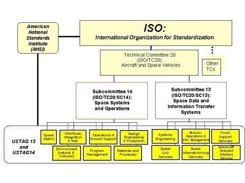
6 ORGANIZATION Pg 6 of 24
7 TC 20/SC 14 Space systems and operations Participating countries: United States Brazil Canada China France Germany Israel Italy Japan Russia Ukraine UK Different Community of Interest than SC13 Primarily commercial, not agency or national, interests Spans all aspects of space vehicle development, launch, and on orbit operations Observers and Liaisons: ESA ECSS Belgium Australia India Pg 7 of 24
8 Comparison of CCSDS and ISO TC 20/SC 14/WG 3 Efforts Orbit data message Orbit data exchange Pre-flight planning for tracking and navigation support Scheduling tracking support Carrying out tracking operations Metric predicts Carrying out navigation operations such as orbit propagation Cooperative Operations Phasing and scheduling station keeping within ITU designated Geostationary orbits Interpretation of scientific data gathered in Earth orbit Collaborative Mission Support Cooperative tracking, telemetry, and commanding Conjunction Prediction and Assessment Pg 8 of 24

9 Comparison of OPM, OEM, and ODE SC 14 ORBIT DATA EXCHANGE Specifies osculating position, velocity, and accelerations in a prescribed reference frame, presentation of mean estimation state variables and their covariances in a prescribed reference frame, and information about physical hypotheses and numerical techniques used to produce these quantities so that parties can independently or collaboratively develop and assess individual or collaborative maneuvers in Earth orbit. Pg 9 of 24


10 Conjunction Assessment with Covariances Pg 10 of 24
11 What is a TLE? A TLE is a set of two eighty column cards in which 69 columns contain data required to propagate with ADCOM (now AFSPACE) physical models satellite orbits determined using congruent models from Air Force Space Surveillance Network (SSN) sensor observations SGP models have evolved over the nearly four decades since they were conceived. Object code copies of SGP models are provided to users by the Air Force, most recently as dynamic link libraries (dll s). Pg 11 of 24
12 TWO LINE ELEMENT SET Line 1 Column Description 01Line Number of Element Data03-07Satellite Number08Classification (U=Unclassified)10-11International Designator (Last two digits of launch year)12-14international Designator (Launch number of the year)15-17international Designator (Piece of the launch)19-20epoch Year (Last two digits of year)21-32epoch (Day of the year and fractional portion of the day)34-43first Time Derivative of the Mean Motion Second Time Derivative of Mean Motion (decimal point assumed)54-61bstar drag term (decimal point assumed)63ephemeris type65-68element number69checksum (Modulo 10) (Letters, blanks, periods, plus signs = 0; minus signs = 1) Line 2 Column Description01Line Number of Element Data03-07Satellite Number09-16Inclination [Degrees]18-25Right Ascension of the Ascending Node [Degrees]27-33Eccentricity (decimal point assumed)35-42argument of Perigee [Degrees]44-51Mean Anomaly [Degrees]53-63Mean Motion [Revs per day]64-68revolution number at epoch [Revs]69Checksum (Modulo 10) NOAA U 94089A Pg 12 of 24
13 Data Fusion Background Level Zero Source Preprocessing Level One Object Refinement Level Two Situation Refinement Level Three Threat Refinement Sources Application Database Management Support Database Fusion Database Level 4 Process Refinement Pg 13 of 24
14 Orbit Product Alternatives Level Zero Source Preprocessing Level One Object Refinement Level Two Situation Refinement Level Three Threat Refinement Sources Application Database Management Support Database Fusion Database Raw Data Level 4 Process Refinemen t In Platform Reference Frame Radar: Angles, Range, Rates Optical: Angles, Angular Rates Interferometers: Position, Velocity Vector Platform State:Orbit, Attitude, Calibrations Aligned Engineering Data Local Tracker or Data Smoother Ephemerides Local Orbit Estimator Orbit Elements (and Covariances) R A E O Pg 14 of 24
15 Degrees of Fusion Data Fusion Raw data from diverse sources at diverse times, expressed in a common reference frame and time basis, are fit to trajectory hypotheses, in order to determine the best description of motion and the deviation of the data set from that hypothesis (covariances) Track Fusion Individual local tracks, based on a small number of sources or a single source are combined according to logical rules of association. Object Fusion Final products, abstracted at the highest level are combined or one among them is selected to govern actions. Pg 15 of 24
16 Orbit Product Alternatives Sensor A (Ground Radar) Sensor B (Space Based Optical) Sensor C (Ground Interferometer) FUSION CENTERS Current USERS Future Data Distribution and Communications Pg 16 of 24
17 BOTTOM LINES TLE s are only one of a wide spectrum of possible orbit data products TLE s generated in different places might be quite different from each other Different versions of TLE production software TLE s centrally fused and distributed as finished products are based on outputs of sensor local data smoothers and not on direct sensor observations Pg 17 of 24
18 Orbit Data Exchange Elements of Information Descriptive Information: Satellite Number, Common Name, International Designator, and Country of Origin, Gravitational Force Information, Non-conservative Force Information. Satellite State: Orbit Elements and Epoch Temporal and Spatial Information: Coordinate System, Coordinate Reference Frame, International Earth Reference System (IERS) Parameters and Epoch State Vector and Covariances: Satellite State of Motion (position, velocity, acceleration, their variances, and coordinate reference); Covariances (estimation state vector solve-for parameters, dimensions, and coordinate reference). Pg 18 of 24
19 Earth Orbit Element Set Message (ESM) ESM requires orbit elements in the same order and the same format as Line 2 of the TLE. Alphanumeric identifiers and other background data from TLE Line 1 are incorporated in the CCSDS Metadata field; a supplementary field that corresponds to TLE Line 1 is allowed. A supplementary ESM Covariance field is specified. The significance of covariances for TLE mean elements is arguable. non-causal correlations may be developed using the variation of TLE s issued at different epochs, and these are more useful for probabilistic assessments than the TLE s themselves. Pg 19 of 24
20 State Vector Message (SVM) Requires Metadata, osculating ephemerides, and causal covariances. The metadata is more comprehensive than ESM metadata, since it includes information about Earth Orientation Parameters, approximations to the Earth s geopotential, atmosphere models, other conservative and nonconservative forces, and other information essential to a recipient s being able to reproduce the provider s result. The mandatory data fields encompass position, velocity, acceleration, and covariance matrix elements all in a specified inertial reference frame and time system. We felt that users should not be burdened with complicated transformations from a provider s unique reference frames. Covariance solve-fors are not standardized, since the state variables one chooses must reflect the provider s unique force, external influence, and measurement uncertainties. However, the data set must include description of the provider s solve-for set. The SVM allows supplementary fields to describe the orbit determination scheme and propagator and supplementary fields in which the specific set of Earth Orientation Parameters can be stated. There are specifications for maneuver fields that include timing and delta V information with which a controlled orbit may be propagated through maneuvers. Multiple maneuver fields are allowed. Pg 20 of 24
21 Progress and Status ESM and SVM collaboratively distilled into a single Orbit Operations Message (OOM) Accommodates all essential elements of information but requires either that providers compose a TLE surrogate from that information or that users parse the full content to extract a TLE surrogate. Pg 21 of 24
22 CCSDS-SC14 Outcomes (Jan 07) That a new message be added to the Orbit Data Message Standard, name to be determined. That the message include elements of data from which canonical TLE s may be constructed. That the message include a 6x6 covariance matrix abstraction. That metadata include covariance solve-fors, but values beyond the 6x6 abstraction need not be provided That information about atmospheric models and other elements of analysis (TBD) that cannot be described precisely enough to allow consumers to reproduce the provider s processes be included in optional fields and not in normative requirements. Investigators often tune or modify standard models and there may be many uncontrolled versions. Pg 22 of 24
23 Related and Coordinated Initiatives AFSPC C2/SSA Community of Interest Working Group TLE Subgroup Enhanced Space System Architecture (ESSA) Joint Concept Technology Demonstration led by USSTRATCOM Pg 23 of 24
24 Call to Action All providers and users should adopt the same extensible schemas for orbit data Those schemas should accommodate the fullness of orbit data products and should not be limited by nor focus on Two Line Element Sets. Pg 24 of 24
The CCSDS Navigation Working Group and Space Situational Awareness. GSAW 2013 Session 11C
 The CCSDS Navigation Working Group and Space Situational Awareness GSAW 2013 Session 11C David Berry Jet Propulsion Laboratory, California Institute of Technology 20-Mar-2013 Copyright 2013 California
ACCURACY ASSESSMENT OF GEOSTATIONARY-EARTH-ORBIT WITH SIMPLIFIED PERTURBATIONS MODELS
 ARTIFICIAL SATELLITES, Vol. 51, No. 2 2016 DOI: 10.1515/arsa-2016-0005 ACCURACY ASSESSMENT OF GEOSTATIONARY-EARTH-ORBIT WITH SIMPLIFIED PERTURBATIONS MODELS Lihua Ma, Xiaojun Xu, Feng Pang National Astronomical
MULTI PURPOSE MISSION ANALYSIS DEVELOPMENT FRAMEWORK MUPUMA
 MULTI PURPOSE MISSION ANALYSIS DEVELOPMENT FRAMEWORK MUPUMA Felipe Jiménez (1), Francisco Javier Atapuerca (2), José María de Juana (3) (1) GMV AD., Isaac Newton 11, 28760 Tres Cantos, Spain, e-mail: fjimenez@gmv.com
Orbit Design Marcelo Suárez. 6th Science Meeting; Seattle, WA, USA July 2010
 Orbit Design Marcelo Suárez Orbit Design Requirements The following Science Requirements provided drivers for Orbit Design: Global Coverage: the entire extent (100%) of the ice-free ocean surface to at
Orekit in NEOSAT FDS. Alexandre Janer& Pol Sola Romeu(TAS) Maxime Journot(CS) Orekit Day 2017 PROPRIETARY INFORMATION 27/11/2017
 Maxime Journot(CS) Orekit Day 2017 PROPRIETARY INFORMATION 27/11/2017") Orekit in NEOSAT FDS Alexandre Janer& Pol Sola Romeu(TAS) Maxime Journot(CS) Orekit Day 2017 1 Modèle 83230347-DOC-TAS-FR-004 Contents TAS &the NEOSAT program NEOSAT FDS -Generalities Orekit in NEOSAT
Orekit in NEOSAT FDS Alexandre Janer& Pol Sola Romeu(TAS) Maxime Journot(CS) Orekit Day 2017 1 Modèle 83230347-DOC-TAS-FR-004 Contents TAS &the NEOSAT program NEOSAT FDS -Generalities Orekit in NEOSAT
Accuracy Assessment of SGP4 Orbit Information Conversion into Osculating Elements
 Accuracy Assessment of SGP4 Orbit Information Conversion into Osculating Elements Saika Aida (1), Michael Kirschner (2) (1) DLR German Space Operations Center (GSOC), Oberpfaffenhofen, 82234 Weßling, Germany,
No End of Push-broom Operations
 Page 1 of 5 ESA Science & Technology 06-Mar-2006 17:30:17 No. 46 - End of Push-broom Operations 23 Dec 2005 Report for period 21 November to 18 December 2005 Smart-1 push-broom operations have continued
COUNTING DOWN TO THE LAUNCH OF POPACS
 COUNTING DOWN TO THE LAUNCH OF POPACS (Polar Orbiting Passive Atmospheric Calibration Spheres) Gil Moore Utah State University Walter Holemans Planetary Systems Corporation Jin Kang U.S. Naval Academy
IMPROVED CONJUNCTION ANALYSIS VIA COLLABORATIVE SPACE SITUATIONAL AWARENESS
 IMPROVED CONJUNCTION ANALYSIS VIA COLLABORATIVE SPACE SITUATIONAL AWARENESS T.S. Kelso (1), D. Vallado (2), J. Chan (3), and B. Buckwalter (4) (1) Center for Space Standards & Innovation, 7150 Campus Drive,
Fundamentals of Astrodynamics and Applications
 Fundamentals of Astrodynamics and Applications Third Edition David A. Vallado with technical contributions by Wayne D. McClain Space Technology Library Published Jointly by Microcosm Press Hawthorne, CA
Implementation of Real-Time Monitoring and Warning of Near-Earth Space Dangerous Events by Roscosmos. I. Oleynikov, V. Ivanov, and M.
 Implementation of Real-Time Monitoring and Warning of Near-Earth Space Dangerous Events by Roscosmos I. Oleynikov, V. Ivanov, and M. Astrakhantsev A lot of uncontrolled man-made objects, which regularly
Long-Term Evolution of High Earth Orbits: Effects of Direct Solar Radiation Pressure and Comparison of Trajectory Propagators
 Long-Term Evolution of High Earth Orbits: Effects of Direct Solar Radiation Pressure and Comparison of Trajectory Propagators by L. Anselmo and C. Pardini (Luciano.Anselmo@isti.cnr.it & Carmen.Pardini@isti.cnr.it)
Orbital Debris Observation via Laser Illuminated Optical Measurement Techniques
 Orbital Debris Observation via Laser Illuminated Optical Measurement Techniques Makoto TAGAWA Kyushu University Toshiya HANADA Kyushu University Kozue HASHIMOTO, Yukihito KITAZAWA, Aritsune KAWABE IHI
Orbital Debris Mitigation
 Orbital Debris Mitigation R. L. Kelley 1, D. R. Jarkey 2, G. Stansbery 3 1. Jacobs, NASA Johnson Space Center, Houston, TX 77058, USA 2. HX5 - Jacobs JETS Contract, NASA Johnson Space Center, Houston,
Space Debris Mitigation Activities at ESA
 Space Debris Mitigation Activities at ESA Heiner Klinkrad ESA Space Debris Office H. Klinkrad, ESA, Feb 2011, page 1 Space Debris Environment in 2010 4,765 launches and 251 on-orbit break-ups led to 16,200
9 th US/Russian Space Surveillance Workshop
 9 th US/Russian Space Surveillance Workshop Real-Time Monitoring and Warning of Near- Earth Space Dangerous Events for Mission Control by MCC TSNIIMASH Federal State Unitary Enterprise Speakers: V. M.
Increasing the Accuracy of Orbital Position Information from NORAD SGP4 Using Intermittent GPS Readings
 Increasing the Accuracy of Orbital Position Information from NORAD SGP4 Using Intermittent GPS Readings Michael Greene Robert E. Zee Space Flight Laboratory University of Toronto 12 August 2009 23 rd Annual
APPENDIX TLE TWO-LINE ELEMENT TRACKING
 APPENDIX TLE TWO-LINE ELEMENT TRACKING Last Revised: 2 August 2012 This appendix is provided as a supplement to the baseline RC4000 manual and the inclined orbit tracking option appendix (Appendix TRK).
Commercial SSA Catalog Performance
 Commercial SSA Catalog Performance Robert Hall Director, ComSpOC Operations Analytical Graphics, Inc. (AGI) Tom Johnson VP of Engineering Analytical Graphics, Inc. (AGI) ABSTRACT We present a summary over
CHAPTER 3 PERFORMANCE
 PERFORMANCE 3.1 Introduction The LM-3A performance figures given in this chapter are based on the following assumptions: Launching from XSLC (Xichang Satellite Launch Center, Sichuan Province, China),
Improvement of Orbits of Geostationary Satellites from Observations Over a Time Interval of Days
 Improvement of Orbits of Geostationary Satellites from Observations Over a Time Interval of 15-2 Days * Konstantin V.Grigoriev, ** Felix R. Hoots * Pulkovo Observatory, St-Petersburg, Russia ** GRC International,
Technical analysis of commercially hosted optical payloads for enhanced SSA
 Technical analysis of commercially hosted optical payloads for enhanced SSA Jonathan D. Lowe Analytical Graphics, Inc., Exton, Pennsylvania, 19341. Email:jlowe@agi.com David A. Vallado Center for Space
Overview of JAXA Activities on Sustainable Space Development and Space Situational Awareness
 Overview of JAXA Activities on Sustainable Space Development and Space Situational Awareness 26 February 2015 Shizuo YAMAMOTO Vice President, JAXA CONTENTS 1. Japan s Space Activities Structure 2. JAXA
How to Improve Small Satellite Missions in Two Easy Steps:
 How to Improve Small Satellite Missions in Two Easy Steps: Adopting Space Debris Mitigation Guidelines and Improving Space Surveillance Network Tracking Support G. Taft DeVere Jason C. Randolph Headquarters
Asia-Pacific ground-base Optical Satellite Observation System APOSOS
 Asia-Pacific ground-base Optical Satellite Observation System APOSOS Center for Research and Application of Space Debris National Astronomical Observatories, CAS GUO Xiaozhong Oct 2011 Outline Space debris
NASA s Activities in Europe
 NASA s Activities in Europe Presented by Dr. Bill Barry NASA European Representative November 10, 2009 at the 2009 International Workshop on Environment and Alternative Energy 2 Current Activities The
AS3010: Introduction to Space Technology
 AS3010: Introduction to Space Technology L E C T U R E 6 Part B, Lecture 6 17 March, 2017 C O N T E N T S In this lecture, we will look at various existing satellite tracking techniques. Recall that we
Collision Risk Assessment for Spacecraft with CASS
 Collision Risk Assessment for Spacecraft with CASS Ma Chaowei 2011, 17-18 Oct 2011 Beijing Institute of Tracking and Telecommunications Technology Ma Chaowei 2 Contents Introduction Basic Information of
CHAPTER 3 PERFORMANCE
 PERFORMANCE 3.1 Introduction The LM-3B performance figures given in this chapter are based on the following assumptions: Launching from XSLC (Xichang Satellite Launch Center, Sichuan Province, China),
Radar-Optical Observation Mix
 Radar-Optical Observation Mix Felix R. Hoots" April 2010! ETG Systems Engineering Division April 19, 10 1 Background" Deep space satellites are those with period greater than or equal to 225 minutes! Synchronous!
International Space Station (ISS) Nears A Six-Figure Orbit Count
 Nears A Six-Figure Orbit Count") 1. Introduction Adopting the definition consistent with ubiquitous two-line element sets (TLEs) used to track virtually any artifact orbiting Earth, an orbit count n tallies the number of northbound equator
1. Introduction Adopting the definition consistent with ubiquitous two-line element sets (TLEs) used to track virtually any artifact orbiting Earth, an orbit count n tallies the number of northbound equator
Periodicity Characterization of Orbital Prediction Error and Poisson Series Fitting
 Periodicity Characterization of Orbital Prediction Error and Poisson Series Fitting Bai Xianzong *, Chen Lei, Tang Guoin College of Aerospace and Materials Engineering, National University of Defense Technology,
IMPROVED ORBITAL DEBRIS TRAJECTORY ESTIMATION BASED ON SEQUENTIAL TLE PROCESSING ABSTRACT
 IAC-09.A6.2.9 IMPROVED ORBITAL DEBRIS TRAJECTORY ESTIMATION BASED ON SEQUENTIAL TLE PROCESSING Alana R. Muldoon, Gabriel H. Elkaim Department of Computer Engineering, University of California, Santa Cruz
AN ANALYTICAL SOLUTION TO QUICK-RESPONSE COLLISION AVOIDANCE MANEUVERS IN LOW EARTH ORBIT
 AAS 16-366 AN ANALYTICAL SOLUTION TO QUICK-RESPONSE COLLISION AVOIDANCE MANEUVERS IN LOW EARTH ORBIT Jason A. Reiter * and David B. Spencer INTRODUCTION Collision avoidance maneuvers to prevent orbital
Assessment and Categorization of TLE Orbit Errors for the US SSN Catalogue
 Assessment and Categorization of TLE Orbit Errors for the US SSN Catalogue Tim Flohrer Aboa Space Research Oy (ASRO) at Space Debris Office, ESA/ESOC, Darmstadt, Germany Tim.Flohrer@esa.int Holger Krag
SPACE SITUATIONAL AWARENESS AND SPACE DEBRIS ACTIVITIES IN INDIA
 SPACE SITUATIONAL AWARENESS AND SPACE DEBRIS ACTIVITIES IN INDIA P Soma, Adjunct Faculty, NIAS Agenda The Growth of Space Objects since 1957 Space Situational Awareness India s Space Assets and SSA Space
AIM RS: Radio Science Investigation with AIM
 Prepared by: University of Bologna Ref. number: ALMARS012016 Version: 1.0 Date: 08/03/2017 PROPOSAL TO ESA FOR AIM RS Radio Science Investigation with AIM ITT Reference: Partners: Radio Science and Planetary
IADC Re-Entry Prediction Campaigns
 IADC Re-Entry Prediction Campaigns H. Klinkrad, ESA IADC chair UNCOPUOS STSC, Feb 2009 page 1 Presentation Outline terms of reference of the Inter-Agency Space Debris Coordination Committee (IADC) concept
Orbit Representation
 7.1 Fundamentals 223 For this purpose, code-pseudorange and carrier observations are made of all visible satellites at all monitor stations. The data are corrected for ionospheric and tropospheric delays,
Research Article The Impact on Geographic Location Accuracy due to Different Satellite Orbit Ephemerides
 Mathematical Problems in Engineering Volume 2009, Article ID 856138, 9 pages doi:10.1155/2009/856138 Research Article The Impact on Geographic Location Accuracy due to Different Satellite Orbit Ephemerides
Sub-millimeter size debris monitoring system with IDEA OSG 1
 Sub-millimeter size debris monitoring system with IDEA OSG 1 Masahiko Uetsuhara, Mitsunobu Okada, Yasunori Yamazaki, Astroscale Pte. Ltd. Toshiya Hanada Kyushu University ABSTRACT The 20-kg class microsatellite
USA Space Debris Environment, Operations, and Policy Updates
 USA Space Debris Environment, Operations, and Policy Updates Presentation to the 48 th Session of the Scientific and Technical Subcommittee Committee on the Peaceful Uses of Outer Space United Nations
USA Space Debris Environment, Operations, and Modeling Updates
 USA Space Debris Environment, Operations, and Modeling Updates Presentation to the 51 st Session of the Scientific and Technical Subcommittee Committee on the Peaceful Uses of Outer Space United Nations
GNSS: Global Navigation Satellite Systems
 GNSS: Global Navigation Satellite Systems Global: today the American GPS (Global Positioning Service), http://gps.losangeles.af.mil/index.html the Russian GLONASS, http://www.glonass-center.ru/frame_e.html
SEMI-ANALYTICAL COMPUTATION OF PARTIAL DERIVATIVES AND TRANSITION MATRIX USING STELA SOFTWARE
 SEMI-ANALYTICAL COMPUTATION OF PARTIAL DERIVATIVES AND TRANSITION MATRIX USING STELA SOFTWARE Vincent Morand, Juan Carlos Dolado-Perez, Hubert Fraysse (1), Florent Deleflie, Jérôme Daquin (2), Cedric Dental
SA/SNZ TS ISO :2015
 (ISO/TS 19130-2:2014, IDT) Australian/New Zealand Technical Specification Geographic information Imagery sensor models for geopositioning Part 2: SAR, InSAR, lidar and sonar SA/SNZ TS ISO 19130.2:2015
Evaluating Gooding Angles-only Orbit Determination of Space Based Space Surveillance Measurements
 Evaluating Gooding Angles-only Orbit Determination of Space Based Space Surveillance Measurements David A. Vallado Center for Space Standards and Innovation, Colorado Springs, Colorado, 80920. Email:dvallado@agi.com
STUDY THE SPACE DEBRIS IMPACT IN THE EARLY STAGES OF THE NANO-SATELLITE DESIGN
 ARTIFICIAL SATELLITES, Vol. 51, No. 4 2016 DOI: 10.1515/arsa-2016-0014 STUDY THE SPACE DEBRIS IMPACT IN THE EARLY STAGES OF THE NANO-SATELLITE DESIGN Mohammed Chessab Mahdi Al-Furat Al-Awsat Technical
An Optical Survey for Space Debris on Highly Eccentric MEO Orbits
 An Optical Survey for Space Debris on Highly Eccentric MEO Orbits T. Schildknecht 1), A. Hinze 1), A. Vananti 1), T. Flohrer ) 1) Astronomical Institute, University of Bern, Sidlerstr. 5, CH-31 Bern, Switzerland
Figure 1. View of ALSAT-2A spacecraft
 ALSAT-2A TRANSFER AND FIRST YEAR OPERATIONS M. Kameche (1), A.H. Gicquel (2), D. Joalland (3) (1) CTS/ASAL, 1 Avenue de la Palestine, BP 13, Arzew 31200 Oran, Algérie, email:mo_kameche@netcourrier.com
The Inter-Agency Space Debris Coordination Committee (IADC)
") The Inter-Agency Space Debris Coordination Committee (IADC) An overview of IADC s annual activities Mitsuru Ohnishi, JAXA, Japan IADC Chair www.iadc-online.org 55 th Session of the Scientific and Technical
The Inter-Agency Space Debris Coordination Committee (IADC) An overview of IADC s annual activities Mitsuru Ohnishi, JAXA, Japan IADC Chair www.iadc-online.org 55 th Session of the Scientific and Technical
NGA GNSS Division Precise Ephemeris Parameters
 NGA GNSS Division Precise Ephemeris Parameters Precise Ephemeris Units. Earth-centered, Earth-fixed Coordinate system Position Velocity GPS time Trajectory interval Standard Trajectory Optional Trajectory
RAPID GEOSYNCHRONOUS TRANSFER ORBIT ASCENT PLAN GENERATION. Daniel X. Junker (1) Phone: ,
 Phone: ,") RAPID GEOSYNCHRONOUS TRANSFER ORBIT ASCENT PLAN GENERATION Daniel X. Junker (1) (1) LSE Space GmbH, Argelsrieder Feld 22, 82234 Wessling, Germany, Phone: +49 160 9111 6696, daniel.junker@lsespace.com Abstract:
RAPID GEOSYNCHRONOUS TRANSFER ORBIT ASCENT PLAN GENERATION Daniel X. Junker (1) (1) LSE Space GmbH, Argelsrieder Feld 22, 82234 Wessling, Germany, Phone: +49 160 9111 6696, daniel.junker@lsespace.com Abstract:
Ontology Summit Framing the Conversation: Ontologies within Semantic Interoperability Ecosystems
 Ontology Summit 2016 Framing the Conversation: Ontologies within Semantic Interoperability Ecosystems GeoSciences Track: Semantic Interoperability in the GeoSciences Gary Berg-Cross and Ken Baclawski Co-Champions
LOTNAV. A Low-Thrust Interplanetary Navigation Tool: The Trajectory Reconstruction Module
 LOTNAV A Low-Thrust Interplanetary Navigation Tool: The Trajectory Reconstruction Module Juan Luis Cano González Mission Analysis Division Deimos Space S.L. -1- The LOTNAV Tool The Low-Thrust Interplanetary
SECTION 9 ORBIT DATA - LAUNCH TRAJECTORY
 SECTION 9 ORBIT DATA - LAUNCH TRAJECTORY --~'- SECTION 9 LAUNCH TRAJECTORY 9.1 MISSION PROFILE IUE was launched by a three-stage Delta 2914 launch vehicle from Cape Kennedy on January 26, 1978 at l7 h
Experimental Analysis of Low Earth Orbit Satellites due to Atmospheric Perturbations
 Experimental Analysis of Low Earth Orbit Satellites due to Atmospheric Perturbations Aman Saluja #1, Manish Bansal #2, M Raja #3, Mohd Maaz #4 #Aerospace Department, University of Petroleum and Energy
COLLISION RISK ASSESSMENT AND MITIGATION STRATEGY FOR THE GSOC GEO SATELLITES
 COLLISION RISK ASSESSMENT AND MITIGATION STRATEGY FOR THE GSOC GEO SATELLITES Saika Aida (1), Michael Kirschner (2), Florian Meissner (3) (1) DLR German Space Operations Center (GSOC), Münchner Str.20,
Applying Open Standards in Oil Spill Responses
 Applying Open Standards in Oil Spill Responses George Percivall, OGC Chief Engineer Bart de Lathouwer, OGC Director Interoperability Program Athina Trakas, OGC Director European Services SLC Paris 18th
PW-Sat two years on orbit.
 13th of February 2014 is the second anniversary of launch of the first polish student-made satellite PW-Sat. Currently Students' Space Association on Warsaw University of Technology is working on another
The Inter-Agency Space Debris Coordination Committee (IADC)
") The Inter-Agency Space Debris Coordination Committee (IADC) An overview of the IADC annual activities Holger Krag, ESA IADC Chair www.iadc-online.org 54 th Session of the Scientific and Technical Subcommittee
The Inter-Agency Space Debris Coordination Committee (IADC) An overview of the IADC annual activities Holger Krag, ESA IADC Chair www.iadc-online.org 54 th Session of the Scientific and Technical Subcommittee
Yahsat s Approach to GEO Collision Avoidance A Case Stduy with STTW-4
 Yahsat s Approach to GEO Collision Avoidance A Case Stduy with STTW-4 John Baker Senior Manager - Flight Dynamics Yahsat Agenda Objective Collision Risk Know your enemy Situational Awareness Yahsat Stationkeeping
INTER-AGENCY SPACE DEBRIS COORDINATION COMMITTEE (IADC) SPACE DEBRIS ISSUES IN THE GEOSTATIONARY ORBIT AND THE GEOSTATIONARY TRANSFER ORBITS
 SPACE DEBRIS ISSUES IN THE GEOSTATIONARY ORBIT AND THE GEOSTATIONARY TRANSFER ORBITS") INTER-AGENCY SPACE DEBRIS COORDINATION COMMITTEE (IADC) SPACE DEBRIS ISSUES IN THE GEOSTATIONARY ORBIT AND THE GEOSTATIONARY TRANSFER ORBITS Presented to: 37-th Session of the SCIENTIFIC AND TECHNICAL
INTER-AGENCY SPACE DEBRIS COORDINATION COMMITTEE (IADC) SPACE DEBRIS ISSUES IN THE GEOSTATIONARY ORBIT AND THE GEOSTATIONARY TRANSFER ORBITS Presented to: 37-th Session of the SCIENTIFIC AND TECHNICAL
DARPA Perspective on Space Situational Awareness
 DARPA Perspective on Space Situational Awareness Lt Col Travis Blake, Ph.D, Program Manager, Tactical Technology Office International Symposium on Sustainable Space Development and Space Situational Awareness
Proton Launch System Mission Planner s Guide SECTION 2. LV Performance
 Proton Launch System Mission Planner s Guide SECTION 2 LV Performance 2. LV PERFORMANCE 2.1 OVERVIEW This section provides the information needed to make preliminary performance estimates for the Proton
FIBER OPTIC GYRO-BASED ATTITUDE DETERMINATION FOR HIGH- PERFORMANCE TARGET TRACKING
 FIBER OPTIC GYRO-BASED ATTITUDE DETERMINATION FOR HIGH- PERFORMANCE TARGET TRACKING Elias F. Solorzano University of Toronto (Space Flight Laboratory) Toronto, ON (Canada) August 10 th, 2016 30 th AIAA/USU
Tailoring the Observation Scenarios and Data Processing Techniques for Supporting Conjunction Event Assessments
 Tailoring the Observation Scenarios and Data Processing Techniques for Supporting Conjunction Event Assessments T. Flohrer *, B. Bastida Virgili *, H. Krag *, H. Klinkrad *, K. Merz *, T. Schildknecht
CATALOGUING EARTH-ORBITING OBJECTS WITH ssasim
 ABSTRACT CATALOGUING EARTH-ORBITING OBJECTS WITH ssasim Alberto Águeda Maté (1), Isaac Juárez Villares (2), Pablo Muñoz Muñoz (3), Fran Martínez Fadrique (4) GMV, Isaac Newton 11, 28760 Tres Cantos, Spain,
On Sun-Synchronous Orbits and Associated Constellations
 On Sun-Synchronous Orbits and Associated Constellations Daniele Mortari, Matthew P. Wilkins, and Christian Bruccoleri Department of Aerospace Engineering, Texas A&M University, College Station, TX 77843,
Benefits of a Geosynchronous Orbit (GEO) Observation Point for Orbit Determination
 Observation Point for Orbit Determination") Benefits of a Geosynchronous Orbit (GEO) Observation Point for Orbit Determination Ray Byrne, Michael Griesmeyer, Ron Schmidt, Jeff Shaddix, and Dave Bodette Sandia National Laboratories ABSTRACT Determining
Benefits of a Geosynchronous Orbit (GEO) Observation Point for Orbit Determination Ray Byrne, Michael Griesmeyer, Ron Schmidt, Jeff Shaddix, and Dave Bodette Sandia National Laboratories ABSTRACT Determining
METHODS OF BALLISTIC SUPPORT AND SUPERVISION OF RESEARCH AND TECHNOLOGICAL EXPERIMENTS OF FOTON SC
 METHODS OF BALLISTIC SUPPORT AND SUPERVISION OF RESEARCH AND TECHNOLOGICAL EXPERIMENTS OF FOTON SC Jury. M. Ustalov RSC TsSKB-Progress, Samara, Russia Abstract A wide range of research and technological
on space debris objects obtained by the
 KIAM space debris data center for processing and analysis of information on space debris objects obtained by the ISON network Vladimir Agapov, Igor Molotov Keldysh Institute of Applied Mathematics RAS
PERFORMANCE OF THE FIRST ORBIT MANEUVER ON CBERS-1 SATELLITE BY INPE S CONTROL CENTER
 Série Arquimedes, Volume 2, Anais do DINCON 2003, pp. 831-840 2º Congresso Temático de Aplicações de Dinâmica e Controle da Sociedade Brasileira de Matemática Aplicada e Computacional (SBMAC). São José
Results and Analyses of Debris Tracking from Mt Stromlo
 Results and Analyses of Debris Tracking from Mt Stromlo Jizhang Sang 1, Ian Ritchie, Matt Pearson, and Craig Smith EOS Space Systems Pty Ltd, Australia Abstract In the last 2 years, EOS Space Systems has
Building a 4-D Weather Data Cube for the NextGen Initial Operating Capability (IOC)
") Building a 4-D Weather Data Cube for the NextGen Initial Operating Capability (IOC) Friends/Partners in Aviation Weather Vision Forum July 15, 2008 Bruce Lambert - DoD Tom Ryan FAA Jason Tuell NWS 1 Overview
Building a 4-D Weather Data Cube for the NextGen Initial Operating Capability (IOC) Friends/Partners in Aviation Weather Vision Forum July 15, 2008 Bruce Lambert - DoD Tom Ryan FAA Jason Tuell NWS 1 Overview
GIS Visualization: A Library s Pursuit Towards Creative and Innovative Research
 GIS Visualization: A Library s Pursuit Towards Creative and Innovative Research Justin B. Sorensen J. Willard Marriott Library University of Utah justin.sorensen@utah.edu Abstract As emerging technologies
Circular Letter SC7: Satellite Gravity Field Missions SSG 2.193: Gravity Field Missions: Calibration and Validation
 Circular Letter SC7: Satellite Gravity Field Missions SSG 2.193: Gravity Field Missions: Calibration and Validation Many groups around the world are working hard to develop software for analyzing satellite
GEOSTATIONARY/COLLOCATION MISSION ANALYSIS USING FOCUSGAT
 GEOSTATIONARY/COLLOCATION MISSION ANALYSIS USING FOCUSGAT EUROEAN SACE ASTRONOMY CENTRE (ESA/ESAC), MADRID, SAIN 3 6 MAY 010 Isabel Vera Trallero (1), Javier Cuesta Cabanás (1), Ángel Luis Cerviño (1),
Vicky Chu, Jer Ling, Tom Lin, Joe Fong, Feng-Tai Huang, Guey-Shin Chang. April 15, 2011
 FORMOSAT-7/COSMIC-2 Overview Vicky Chu, Jer Ling, Tom Lin, Joe Fong, Feng-Tai Huang, Guey-Shin Chang April 15, 2011 Program Status AIT-TECRO Agreement on FORMOSAT-7/COSMIC-2 joint program has been signed
SHARING SPACE SITUATIONAL AWARENESS DATA. Duane Bird, Major, USAF United States Strategic Command
 SHARING SPACE SITUATIONAL AWARENESS DATA Duane Bird, Major, USAF United States Strategic Command The Commander, United States Strategic Command (CDRUSSTRATCOM) accepted responsibility for sharing space
IDEA OSG 1: PRELAUNCH STATUS REPORT
 IDEA OSG 1: PRELAUNCH STATUS REPORT Masahiko Uetsuhara, Kohei Fujimoto, and Mitsunobu Okada Astroscale PTE. LTD., 6 Battery Road, #38-04 Singapore, 049909 Email: {m.uetsuhara, k.fujimoto, nobu}@astroscale.com
Space research. Horizon Work Programme. "Countdown to Horizon 2020 Space" Earth Observation topics. Brussels, 12 December 2013
 Space research Horizon 2020 - Work Programme "Countdown to Horizon 2020 Space" Earth Observation topics Brussels, 12 December 2013 richard.gilmore@ec.europa.eu Table of contents FP/Copernicus - general
Space environment (natural and artificial) Realtime solar activity and space environment information for spacecraft operation
 Realtime solar activity and space environment information for spacecraft operation") ISO 2008 All rights reserved ISO TC 20/SC 14 N873 Date: 2012-07-31 ISO/CDV 16709 ISO TC 20/SC 14/WG 4 Secretariat: Space environment (natural and artificial) Realtime solar activity and space environment
ISO 2008 All rights reserved ISO TC 20/SC 14 N873 Date: 2012-07-31 ISO/CDV 16709 ISO TC 20/SC 14/WG 4 Secretariat: Space environment (natural and artificial) Realtime solar activity and space environment
Reducing Consumer Uncertainty
 Spatial Analytics Reducing Consumer Uncertainty Eliciting User and Producer Views on Geospatial Data Quality Introduction Cooperative Research Centre for Spatial Information (CRCSI) in Australia Communicate
Identifying On-Orbit Test Targets for Space Fence Operational Testing. Daniel L. Pechkis Nelson S. Pacheco Tye W. Botting
 Identifying On-Orbit Test Targets for Space Fence Operational Testing Daniel L. Pechkis Nelson S. Pacheco Tye W. Botting Institute for Defense Analyses, Alexandria, VA 22311 ABSTRACT Space Fence will be
3 rd US-China Space Surveillance Technical Interchange
 3 rd US-China Space Surveillance Technical Interchange Beijing Institute of Technology Beijing, China 12-16 May 2013 YE Shuhua China Co- P. Kenneth Seidelmann U.S. Co- ZHANG Jingrui China Technical Kyle
STAR CATALOGUE FACILITY
 STAR CATALOGUE FACILITY Alan Batten Science Systems (Space) Ltd., 23 Clothier Road, Bristol BS4 5SS Phone: +44 117 9717251. Fax: +44 117 9711125 E-mail: Alan.Batten@scisys.co.uk ABSTRACT The provision
Ludwig Combrinck HartRAO 3rd Space Geodesy Workshop 16 March 2009 Matjiesfontein
 Space Geodesy and Space Science Ludwig Combrinck HartRAO 3rd Space Geodesy Workshop 16 March 2009 Matjiesfontein DST s Concept of Space Science SA Space Agency, commercial applications, CSIR Satellite
PREDICTING THE ATMOSPHERIC RE-ENTRY OF SPACE DEBRIS THROUGH THE QB50 ENTRYSAT MISSION
 PREDICTING THE ATMOSPHERIC RE-ENTRY OF SPACE DEBRIS THROUGH THE QB50 ENTRYSAT MISSION Y. Prevereaud (1), F. Sourgen (2), D. Mimoun (3), A.Gaboriaud (4), J-L. Verant (5), and J-M. Moschetta (6) (1) ONERA
CHAPTER 3 PERFORMANCE
 PERFORMANCE The launch performance given in this chapter is based on the following assumptions: The LV system parameters being all nominal values; Mass of the LV adapter and the separation system are included
INTELLIGENT AUTONOMY FOR MULTIPLE, COORDINATED UAVS
 INTELLIGENT AUTONOMY FOR MULTIPLE, COORDINATED UAVS PRESENTED BY: Dr. Lora G. Weiss PRESENTED TO: The Institute for Computational Sciences The Pennsylvania State University January 31, 2005 COORDINATED
Jay Lawrimore NOAA National Climatic Data Center 9 October 2013
 Jay Lawrimore NOAA National Climatic Data Center 9 October 2013 Daily data GHCN-Daily as the GSN Archive Monthly data GHCN-Monthly and CLIMAT messages International Surface Temperature Initiative Global
Space Debris Activities in India
 Indian Presentation to the 47 th Session of Scientific and Technical Subcommittee of United Nations Committee on the Peaceful Uses of Outer Space Agenda 8 Space Debris Activities in India 1 Space Debris
The Space-based Telescopes for Actionable Refinement of Ephemeris (STARE) mission
 mission") LLNL-PRES-641541 Performance Measures x.x, x.x, and x.x SSC13-XI-11 The Space-based Telescopes for Actionable Refinement of Ephemeris (STARE) mission Vincent Riot, Willem de Vries, Lance Simms, Brian Bauman,
LLNL-PRES-641541 Performance Measures x.x, x.x, and x.x SSC13-XI-11 The Space-based Telescopes for Actionable Refinement of Ephemeris (STARE) mission Vincent Riot, Willem de Vries, Lance Simms, Brian Bauman,
TUNDRA DISPOSAL ORBIT STUDY
 TUNDRA DISPOSAL ORBIT STUDY Al an B. Jenki n (1 ), John P. McVey (2 ), James R. Wi l son (3 ), Marl on E. Sorge (4) (1) The Aerospace Corporation, P.O. Box 92957, Los Angeles, CA 90009-2957, USA, Email:
Tactical Ballistic Missile Tracking using the Interacting Multiple Model Algorithm
 Tactical Ballistic Missile Tracking using the Interacting Multiple Model Algorithm Robert L Cooperman Raytheon Co C 3 S Division St Petersburg, FL Robert_L_Cooperman@raytheoncom Abstract The problem of
Benefits of Applying Predictive Intelligence to the Space Situational Awareness (SSA) Mission
 Mission") Benefits of Applying Predictive Intelligence to the Space Situational Awareness (SSA) Mission Abstract Ben Lane and Brian Mann Military Civil Space and Ground (MCS&G) Northrop Grumman Electronic Systems
Benefits of Applying Predictive Intelligence to the Space Situational Awareness (SSA) Mission Abstract Ben Lane and Brian Mann Military Civil Space and Ground (MCS&G) Northrop Grumman Electronic Systems
Validation of Astrodynamic Formation Flying Models Against SPACE-SI Experiments with Prisma Satellites
 Validation of Astrodynamic Formation Flying Models Against SPACE-SI Experiments with Prisma Satellites Drago Matko, Tomaž Rodič, Sašo Blažič, Aleš Marsetič, Krištof Oštir, Gašper Mušič, Luka Teslić, Gregor
GOES-R Instrument Status and Accommodations. Barbara Pfarr GOES-R Program Systems Engineering January 2010 AMS Conference
 GOES-R Instrument Status and Accommodations Barbara Pfarr GOES-R Program Systems Engineering January 2010 AMS Conference Agenda Instrument Developmental Status Significant Changes in the Last Year Introducing
Green Chemistry Education
 Green Chemistry Education Poster presented at the IUPAC Congress/General Assembly July 2001 GREEN CHEMISTRY IN THE SCIENTIFIC CONTEXT The science of chemistry is central to addressing the problems facing