Grundlagen Fernerkundung - 12
|
|
|
- Kevin Ellis
- 5 years ago
- Views:
Transcription
1 Grundlagen Fernerkundung - 12 Image classification GEO123.1, FS2015 Michael Schaepman, Rogier de Jong, Reik Leiterer 5/7/15 Page 1

2 5/7/15 Grundlagen Fernerkundung FS2011 Page 2

3 5/7/15 Grundlagen Fernerkundung FS2011 Page 3


4 Department of Geography Landcover Classification Improvement 75.0% 90.0% 92.1%
5 Today s topics & learning goals Feature space How are land cover classes separated from each other? Classification algorithms Which algorithms exist and how do they differ? Accuracy measures How valid is a classification result?
6 Feature Space (Eigenschaftsraum / Merkmalsraum) Albertz, 2001


7 Feature space: NIR vs RED

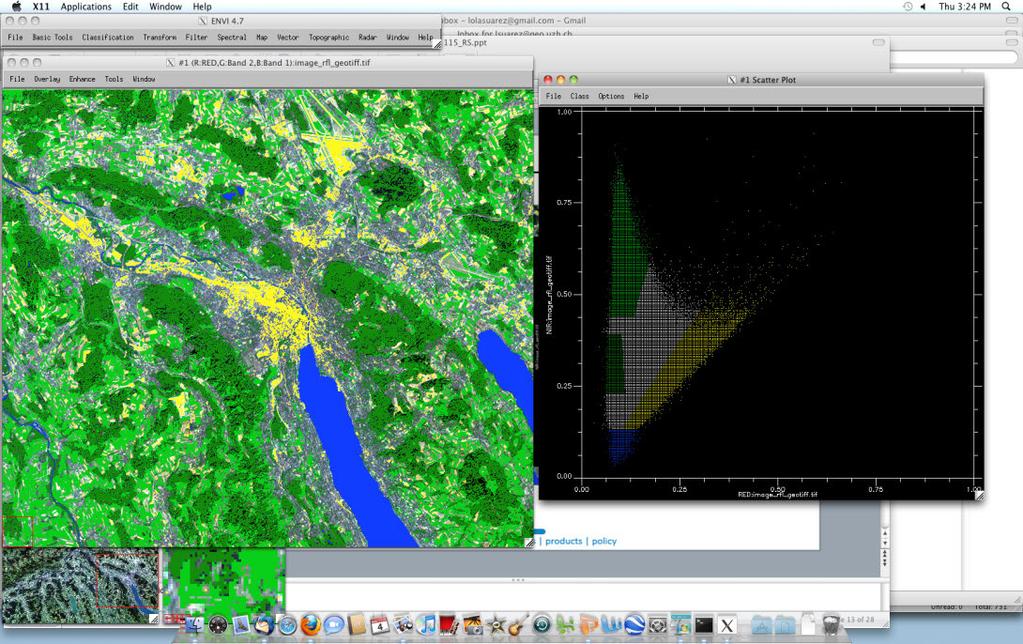
8 Department of Geography Feature space: NIR vs RED
9 Statistical description of spectral clusters Histogram / distribution curve Min, Mean, Max values Standard deviations
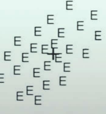
10 Spectral clustering using the feature space Ground features are defined based on their spectral response Points 1-3 are unknown features that need to be assigned to A-E! = wavelength Messwerte = reflectance

 OG A2 UG A2 UG")
11 Method 1: Parallelepiped classification OG = Obergrenze (upper limit) UG = Untergrenze (lower limit) OG A2 UG A2 UG A1 OG A1
12 Method 1: Parallelepiped classification OG = Obergrenze (upper limit) UG = Untergrenze (lower limit) OG E2 OG A2 UG A2 = UG E2 UG A1 OG A1 UG E1 OG E1
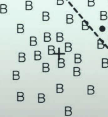
13 Method 1: Parallelepiped classification Features B and C cannot be distinguished. You ll need to try other spectral channels for this purpose. Point 2 is therefore the most uncertain but with only this information classified as B
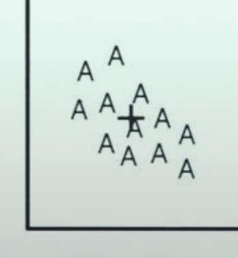
14 Method 2: Minimum-distance classification Criterium: smallest Euclidean distance to the mean value of the class (+) Boundaries are perpendiculars ( Mittelsenkrechte )! = wavelength Messwerte = reflectance

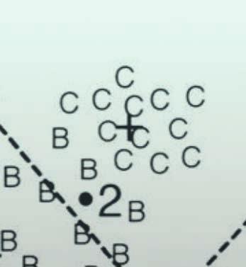


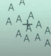
15 Method 2: Minimum-distance classification Without a max-distance threshold, point 3 changed from unclassified to E Point 2 has changed from B to C Less overlap between class B and C but more misclassifications of Bs as Cs?
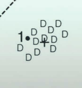
16 Method 3: Maximum-likelihood classification Criterium: maximum likelihood ( Mutmasslichkeit ) according to a probabilitydensity function ( Wahrscheinlichkeitsdichte-Funktion ) Boundaries: number of standard deviations (sigma)

17 Method 3: Maximum-likelihood classification Point 3: more than x sigma distance and thus unclassified 1 sigma probability 2 sigma etc. Point 2: class B with 2 sigma distance
18 Common classification algorithms: overview Parallelepiped Minimum Distanz Maximum Likelihood
19 User supervision ( Überwachung ) Unsupervised classification The user does not provide information with respect to the classes Classes are defined based on statistical properties Given the same dataset and same method, each user obtains the identical result Supervised classification The user defines training classes to which unclassified pixels are being compared The result depends on the definition of the training classes and is therefore likely to change between users


 clusters")

20 Method 4: Unsupervised clustering Option 1: no a-priori information at all, (number of) clusters are estimated from statistics Cluster 1 Cluster 2 Cluster 4 Cluster 3


21 Method 4: Unsupervised clustering Option 2: the user defines (only) the number of classes, i.e. 5 Cluster 1 Cluster 2 After classification (option 1 or 2), clusters may be assigned to features of interest based on user knowledge Cluster 5 Cluster 3 Cluster 4
22 Classification methods Albertz, 2001 Unsupervised classification Supervised classification Clustering, (Segmentation)... Parallelepiped, Minimum distance, Maximum likelihood...


23 How accurate is your classification? Landsat Thematic Mapper, K 2,4,7 Looks good! Seems plausible! Is that enough though?
24 A classification is not complete until it has been assessed. (R.G. CONGALTON 1991:35)

25


accuracy to the")
26 For a given point, how likely is it that the classification represents the reality? How accurate are the various classes? How can we communicate the (in)accuracy to the users of our maps?
27 Options for accurcay assessment Vergleich mit Bild (visuell) -> sehr unzuverlässig, nicht-quantitativ Vergleich mit Karte (visuell) -> unzuverlässig, nicht-quantitativ Vergleich mit ground truth (visuell) -> bedingt abschätzbar, nicht-quantitativ Vergleich mit ground truth (digital) -> zuverlässig, häufig angewendet, quantitativ Unabhängige Verwendung von -> zuverlässig, häufig angewendet, quantitativ ground truth für Training des Klassifikators und Validierung (digital) Vergleich mit unabhängiger/ statistisch basierter Referenz (digital) -> best practice, sehr zuverlässig, quantitativ


28 Department of Geography Accuracy assessment Aerial image HRSC-AX Visual comparison: How accurate has Vegetation been classified? Digital comparison with ground truth map: Only 56% of the actual Vegetation has been classified as Vegetation Classes: Water, Vegetation, Bare / built-up
29 Error matrix ( Fehlermatrix ) (synonym: confusion matrix, matching matrix, contingency table) Classification Reference / ground truth Forest Arable Other vegetation Bare / built-up
30 Error matrix Referenz/ ground truth A B C D! Referenz/ ground truth A B C D! Forest Arable Other vegetation Bare / built-up
31 Error matrix Referenz/ ground truth Referenz/ ground truth A B C D! A B C D ! Forest Other vegetation Arable Bare / built-up
32 Error matrix Referenz/ ground truth A B C D! A n AA nx AB nx AC nx AD n A+ X X X B n BA n BB n BC n BD n B+ X X X C n CA n CB n CC n CD n C+ D n X DA nx DB n DC n DD n D+ X! n +A n +B n +C n +D n ++ N A+ Number of pixels classified as A N +A Number of pixels found to be A in reference Correctly classified (classification == reference) Incorrectly classified (classification " reference) Grand total (total pixel count)
33 Error matrix Referenz/ ground truth A Referenz/ ground truth A B C D! B C D ! Forest Arable Other vegetation Bare / built-up Correctly classified classification == reference Incorrectly classified classification " reference
34 Type 1 (commission) and type 2 (omission) error Referenz/ ground truth Referenz/ ground truth A B C D! A B C D ! Incorrectly classified classification " reference -! Type 1: Commission Error Pixels were included in the class, although they should not have been -! Type 2: Omission Error Pixels were not included in the class, although they should have been
35 Type 1 (commission) and type 2 (omission) error Type 1 (commission error) example for class Forest Referenz/ ground truth Type 2 (ommission error) example for class Forest Referenz/ ground truth
36 Accuracy metrics (or: error metrics) Referenz/ ground truth A B C D! A n AA nx AB nx AC nx AD n A+ X X X B n BA n BB n BC n BD n B+ X X X C n CA n CB n CC n CD n C+ D n X DA nx DB n DC n DD n D+ X! n +A n +B n +C n +D n ++ N A+ Number of pixels classified as A N +A Number of pixels found to be A in reference Correctly classified (classification == reference) Incorrectly classified (classification " reference) Grand total (total pixel count) Accuracy metrics: measures for classification accuracy based on the error matrix
37 Accuracy metrics English Deutsch Overall Accuracy Gesamtgenauigkeit Producer Accuracy Produzenten-Genauigkeit User Accuracy Nutzer-Genauigkeit Average Accuracy durchschnittliche Genauigkeit Mean Accuracy mittlere Genauigkeit Kappa Coefficient Kappa Koeffizient
38 Overall/ Total Accuracy (OA) Referenz/ ground truth A B C D! A B C D Referenz! Overall Accuracy = Count of correctly classified pixels Grand total (total pixel count) = = (~90.6%)
39 Genauigkeitsmasse Overall/ Total Accuracy (OA) (GLC2000) Referenz/ ground truth A B C D! A Die Overall Accuracy ist ein einfaches Genauigkeitsmass, aber wenig aussagekräftig! B Fehler 1. Art (Commission) und C Fehler Art 24 (Omission) 2 30 werden nicht berücksichtigt! D Referenz! Overall die Summe der richtig klassifizierten Pixel Accuracy = Gesamtanzahl aller Pixel/ Grundgesamtheit = = (~90.6%)
40 Producer s Accuracy (PA) Referenz/ ground truth A B C D! A B C The producer needs to know how well her/his classification (e.g. for class A) matches with the reference Referenz D ! PA == Omission Error How many pixels should have been in the class but were not Producer s Accuracy = count of correctly classified pixels in class count of pixels in same reference class = = (~83.3%)
41 User s Accuracy (UA) Referenz/ ground truth A B C D! UA A B C The user needs to know how well a class (e.g. A) matches with the reality Referenz D ! == Commission Error How many pixels are in the class but should not have been User s Accuracy = count of correctly classified pixels in class count of all pixels in that class = = 1 (100%)
42 Accuracy metrics OA, PA, UA Referenz/ ground truth A B C D! UA [%] A If I classified a pixel as forest (A), there is in 100% of the cases indeed forest at that location B C I have captured 100% of the existing arable land (C) with my classification Referenz D ! But: 20% of the classified arable land (C) pixels has another land cover in reality PA [%] OA [%] But: 16.67% of the existing forest (A) was not captured
43 Accuracy metrics OA, PA, UA Referenz/ ground truth A B C D! UA [%] A B C % of all classified pixels matches with the reference / reality D Referenz! PA [%] OA [%] 90.63
44 Hands-on! A A A B B A A A B B A A A B B B B B B B A A A A B A A A B B A A A B B B B B B B Referenz/ ground truth PA [%] OA [%] Referenz A B! A B! 20 UA [%]
45 Hands-on! A A A B B A A A B B A A A B B B B B B B A A A A B A A A B B A A A B B B B B B B Referenz/ ground truth Referenz A B! A B ! PA [%] OA [%] UA [%]
46 Mean UA (or: average accuracy) Referenz/ ground truth A B C D! UA [%] Overall Accuracy % A B C Mean UA % D Referenz! PA [%] Average Accuracy = sum of all user accuracies number of classes = 380% 4 = 95%
47 Mean classification accuracy Referenz/ ground truth A B C D! A B C UA [%] Overall Accuracy % Mean UA % Mean Accuracy % D Referenz! PA [%] Mean Overall Accuracy + Mean UA Accuracy = 2 = = 92.82%
48 Genauigkeitsmasse Kappa Coefficient/ KHAT statistic Referenz Referenz/ ground truth A B C D! A B C D Unterschied der Übereinstimmung zwischen > Referenz und Zufallsklassifikation > Referenz. Zu welchem Anteil sind die korrekt klassifizierten Pixel zufällig richtig? Zufalls-! Um welchen Prozentsatz ist meine besser im Vergleich zu einer rein zufälligen?
49 Genauigkeitsmasse Kappa Coefficient Referenz/ ground truth A B C D! A B C D Referenz! Kappa Coefficient ^ ( k ) = Overall Accuracy 1 - Zufallsübereinstimmung - Zufallsübereinstimmung
50 Genauigkeitsmasse Kappa Coefficient Referenz/ ground truth A B C D! A B C Summe der richtig klassifizierten Pixel Grundgesamtheit = = 58 = 64 Overall Accuracy = D Referenz! Kappa Coefficient = Overall Accuracy 1 - Zufallsübereinstimmung - Zufallsübereinstimmung
51 Genauigkeitsmasse Kappa Coefficient Referenz/ ground truth A B C D! A Overall Accuracy = B C D Zufalls- = Summe der übereinstimmung Produkte der Zeilen- und Spaltensummen Referenz! Grundgesamtheit 2 Kappa Coefficient = Zufallsübereinstimmung - Zufallsübereinstimmung
52 Genauigkeitsmasse Kappa Coefficient Referenz/ ground truth A B C D! A Overall Accuracy = B C D Zufalls- = Summe der übereinstimmung Produkte der Zeilen- und Spaltensummen Referenz! Grundgesamtheit 2 Kappa Coefficient = Zufallsübereinstimmung - Zufallsübereinstimmung
53 Genauigkeitsmasse Kappa Coefficient Referenz/ ground truth A B C D! A Overall Accuracy = B C D Zufalls- = Summe der übereinstimmung Produkte der Zeilen- und Spaltensummen Referenz! Kappa Coefficient = Zufallsübereinstimmung - Zufallsübereinstimmung
54 Genauigkeitsmasse Kappa Coefficient Referenz/ ground truth A B C D! A Overall Accuracy = B C D Zufalls- = (15x18)+ übereinstimmung (9x10)+ (30x24)+ (10x12) Referenz! Kappa Coefficient = Zufallsübereinstimmung - Zufallsübereinstimmung
55 Genauigkeitsmasse Kappa Coefficient Referenz/ ground truth A B C D! A Overall Accuracy = B C Zufallsübereinstimmung = = D Referenz! Kappa Coefficient = Zufallsübereinstimmung - Zufallsübereinstimmung


56 Genauigkeitsmasse Kappa Coefficient Referenz/ ground truth A B C D! A Overall Accuracy = B C Zufalls- = übereinstimmung D Referenz Kappa Coefficient = ! = Kann interpretiert werden als: Meine ist 86.74% besser im Vergleich zu einer rein zufälligen!
57 Genauigkeitsmasse Kappa Coefficient -! vielfältig interpretierbar -> es existieren verschiedene Richtwerte für die Beurteilung des Koeffizienten Kappa - Coefficient Level of Agreement to Reference 0.00 poor / slight / schwach fair / leicht moderate / mittelmäßig substantial / gut almost perfect / sehr gut!"#$%&'()'*)+,-).// ! keine allgemeingültigen Aussagen möglich!
58 Genauigkeitsmasse Kappa Coefficient -! keine allgemeingültigen Aussagen möglich! A A A A A A A A A A A A A A A A A A A B Wald Sonstige Vegetation A A A A A A A A A C Ackerland Vegetationsfrei A A A A A A A A A D Referenz/ ground truth Kappa Coefficient = 0 OA = 85% Kappa - Coefficient Level of Agreement to Reference 0.00 poor / slight / schwach fair / leicht moderate / mittelmäßig substantial / gut almost perfect / sehr gut
59 Accuracy assessment summary Referenz A B C D! A n AA n AB n AC n AD n A+ Overall Accuracy = q! i = 1 n n ii PA = n ii n +i UA = n ii n i+ B n BA n BB n BC n BD n B+ C n CA n CB n CC n CD n C+ D n DA n DB n DC n DD n D+! N +A N +B N +C N +D n Mean UA Accuracy = q! UA i = 1 n Mean UA OA + Mean Accuracy = Accuracy 2 q = Anzahl an Klassen n = Grundgesamtheit n ii = Anzahl übereinstimmender Pixel n i+ = Summe der Zeilenwerte n +i = Summe der Spaltenwerte
60 Accuracy metrics applying them correctly Accuracy metrics depend on the sampling scheme of the reference x x x x x x x x x x x x x x x x x x x x x x x x x x x x x x x x x x x x x x x x x x x x x x x x x x x x x x x x x x x x x x x x x x x x x x x x x x x x x x x x x x x x x x x x x x x x x x x x x x x x x x x x x x x x x x x x x x x x x x x x x x x x x x x x x x x x x x x x x x x x OA = 95.6% Forest ("20%) Forest (< 20%) Grassland Water Referenz/ ground truth A B C D! A B C D !
61 Accuracy metrics applying them correctly Accuracy information depend on the choice of metric x x x x x x x x x x x x x x x x x x x x x x x x x x x x x x x x x x x x x x x x x x x x x x x x x x x x x x x x x x x x x x x x x x x x x x x x x x x x x x x x x x x x x x x x x x x x x x x x x x x x x x x x x x x x x x x x x x x x x x x x x x x x x x x x x x x x x x x x x x x x OA = 95.6% Mean user accuracy = 72.0% Mean classification accuracy = 83.9% Forest ("20%) Forest (< 20%) Grassland Water PA UA
62 Accuracy metrics applying them correctly Accuracy information depend on the interpretation of the metric
63 Accuracy Take-Home Messages A classification is not complete until it has been assessed. You need multiple accuracy metrics to get a good representation of the actual accuracy; a single metric may lead to an incorrect assessment The reference dataset must be representative for the classification Be critical when you communicate your classification to your users
64 Requirements regarding the previous two lectures (on Image analysis and Image classification ) Image analysis Understand the concepts of (visualizing) spectral bands Understand simple band operations and what they can be used for Know various change-detection techniques (concepts, no tech. details) Be able to describe and recognize low-pass and high-pass filters Classification Know different (types of) algorithms (characteristics, pros and cons), be able to describe them and to conceptually apply them Be able to describe and apply the various accuracy metrics

65 Thank you for your attention!
Sub-pixel regional land cover mapping. with MERIS imagery
 Sub-pixel regional land cover mapping with MERIS imagery R. Zurita Milla, J.G.P.W. Clevers and M. E. Schaepman Centre for Geo-information Wageningen University 29th September 2005 Overview Land Cover MERIS
o 3000 Hannover, Fed. Rep. of Germany
 1. Abstract The use of SPOT and CIR aerial photography for urban planning P. Lohmann, G. Altrogge Institute for Photogrammetry and Engineering Surveys University of Hannover, Nienburger Strasse 1 o 3000
Urban land cover and land use extraction from Very High Resolution remote sensing imagery
 Urban land cover and land use extraction from Very High Resolution remote sensing imagery Mengmeng Li* 1, Alfred Stein 1, Wietske Bijker 1, Kirsten M.de Beurs 2 1 Faculty of Geo-Information Science and
International Journal of Scientific & Engineering Research, Volume 6, Issue 7, July ISSN
 International Journal of Scientific & Engineering Research, Volume 6, Issue 7, July-2015 1428 Accuracy Assessment of Land Cover /Land Use Mapping Using Medium Resolution Satellite Imagery Paliwal M.C &.
GEOG 4110/5100 Advanced Remote Sensing Lecture 12. Classification (Supervised and Unsupervised) Richards: 6.1, ,
 Richards: 6.1, ,") GEOG 4110/5100 Advanced Remote Sensing Lecture 12 Classification (Supervised and Unsupervised) Richards: 6.1, 8.1-8.8.2, 9.1-9.34 GEOG 4110/5100 1 Fourier Transforms Transformations in the Frequency Domain
GEOG 4110/5100 Advanced Remote Sensing Lecture 12 Classification (Supervised and Unsupervised) Richards: 6.1, 8.1-8.8.2, 9.1-9.34 GEOG 4110/5100 1 Fourier Transforms Transformations in the Frequency Domain
Deriving Uncertainty of Area Estimates from Satellite Imagery using Fuzzy Land-cover Classification
 International Journal of Information and Computation Technology. ISSN 0974-2239 Volume 3, Number 10 (2013), pp. 1059-1066 International Research Publications House http://www. irphouse.com /ijict.htm Deriving
AN INVESTIGATION OF AUTOMATIC CHANGE DETECTION FOR TOPOGRAPHIC MAP UPDATING
 AN INVESTIGATION OF AUTOMATIC CHANGE DETECTION FOR TOPOGRAPHIC MAP UPDATING Patricia Duncan 1 & Julian Smit 2 1 The Chief Directorate: National Geospatial Information, Department of Rural Development and
GeoComputation 2011 Session 4: Posters Accuracy assessment for Fuzzy classification in Tripoli, Libya Abdulhakim khmag, Alexis Comber, Peter Fisher ¹D
 Accuracy assessment for Fuzzy classification in Tripoli, Libya Abdulhakim khmag, Alexis Comber, Peter Fisher ¹Department of Geography, University of Leicester, Leicester, LE 7RH, UK Tel. 446252548 Email:
Preparation of LULC map from GE images for GIS based Urban Hydrological Modeling
 International Conference on Modeling Tools for Sustainable Water Resources Management Department of Civil Engineering, Indian Institute of Technology Hyderabad: 28-29 December 2014 Abstract Preparation
IMAGE CLASSIFICATION TOOL FOR LAND USE / LAND COVER ANALYSIS: A COMPARATIVE STUDY OF MAXIMUM LIKELIHOOD AND MINIMUM DISTANCE METHOD
 IMAGE CLASSIFICATION TOOL FOR LAND USE / LAND COVER ANALYSIS: A COMPARATIVE STUDY OF MAXIMUM LIKELIHOOD AND MINIMUM DISTANCE METHOD Manisha B. Patil 1, Chitra G. Desai 2 and * Bhavana N. Umrikar 3 1 Department
Linear Classifiers. Michael Collins. January 18, 2012
 Linear Classifiers Michael Collins January 18, 2012 Today s Lecture Binary classification problems Linear classifiers The perceptron algorithm Classification Problems: An Example Goal: build a system that
NR402 GIS Applications in Natural Resources. Lesson 9: Scale and Accuracy
 NR402 GIS Applications in Natural Resources Lesson 9: Scale and Accuracy 1 Map scale Map scale specifies the amount of reduction between the real world and the map The map scale specifies how much the
MetroCount Traffic Executive Individual Vehicles
 Individual-34 Page 1 MetroCount Traffic Executive Individual Vehicles Individual-34 -- English (ENA) Datasets: Site: [00001] Old Coast Rd 4km N of Od Bunbury Rd Direction: 5 - South bound A>B, North bound
1. Introduction. S.S. Patil 1, Sachidananda 1, U.B. Angadi 2, and D.K. Prabhuraj 3
 Cloud Publications International Journal of Advanced Remote Sensing and GIS 2014, Volume 3, Issue 1, pp. 525-531, Article ID Tech-249 ISSN 2320-0243 Research Article Open Access Machine Learning Technique
Temporal and spatial approaches for land cover classification.
 Temporal and spatial approaches for land cover classification. Ryabukhin Sergey sergeyryabukhin@gmail.com Abstract. This paper describes solution for Time Series Land Cover Classification Challenge (TiSeLaC).
Assessing Limits of Classification Accuracy Attainable through Maximum Likelihood Method in Remote Sensing
 Asian Journal of Water, Environment and Pollution, Vol. 1, No. 1 & 2, pp. 99-108. Assessing Limits of Classification Accuracy Attainable through Maximum Likelihood Method in Remote Sensing R.K. Gupta,
Lesson 6: Accuracy Assessment
 This work by the National Information Security and Geospatial Technologies Consortium (NISGTC), and except where otherwise Development was funded by the Department of Labor (DOL) Trade Adjustment Assistance
Comparative Analysis of Supervised and
 Applied Mathematical Sciences, Vol.,, no., 68-69 HIKARI Ltd, www.m-hikari.com http://dx.doi.org/.988/ams.. Comparative Analysis of Supervised and Unsupervised Classification on Multispectral Data Asmala
A COMPARISON BETWEEN DIFFERENT PIXEL-BASED CLASSIFICATION METHODS OVER URBAN AREA USING VERY HIGH RESOLUTION DATA INTRODUCTION
 A COMPARISON BETWEEN DIFFERENT PIXEL-BASED CLASSIFICATION METHODS OVER URBAN AREA USING VERY HIGH RESOLUTION DATA Ebrahim Taherzadeh a, Helmi Z.M. Shafri a, Seyed Hassan Khalifeh Soltani b, Shattri Mansor
A Method to Improve the Accuracy of Remote Sensing Data Classification by Exploiting the Multi-Scale Properties in the Scene
 Proceedings of the 8th International Symposium on Spatial Accuracy Assessment in Natural Resources and Environmental Sciences Shanghai, P. R. China, June 25-27, 2008, pp. 183-188 A Method to Improve the
Hyperspectral image classification using Support Vector Machine
 Journal of Physics: Conference Series OPEN ACCESS Hyperspectral image classification using Support Vector Machine To cite this article: T A Moughal 2013 J. Phys.: Conf. Ser. 439 012042 View the article
Overview on Land Cover and Land Use Monitoring in Russia
 Russian Academy of Sciences Space Research Institute Overview on Land Cover and Land Use Monitoring in Russia Sergey Bartalev Joint NASA LCLUC Science Team Meeting and GOFC-GOLD/NERIN, NEESPI Workshop
Combination of Microwave and Optical Remote Sensing in Land Cover Mapping
 Combination of Microwave and Optical Remote Sensing in Land Cover Mapping Key words: microwave and optical remote sensing; land cover; mapping. SUMMARY Land cover map mapping of various types use conventional
High resolution wetland mapping I.
 High resolution wetland mapping I. Based on the teaching material developed by Steve Kas, GeoVille for WOIS Product Group #5 Dr. Zoltán Vekerdy and János Grósz z.vekerdy@utwente.nl vekerdy.zoltan@mkk.szie.hu
Comparing CORINE Land Cover with a more detailed database in Arezzo (Italy).
.") Comparing CORINE Land Cover with a more detailed database in Arezzo (Italy). Javier Gallego JRC, I-21020 Ispra (Varese) ITALY e-mail: javier.gallego@jrc.it Keywords: land cover, accuracy assessment, area
Comparing CORINE Land Cover with a more detailed database in Arezzo (Italy). Javier Gallego JRC, I-21020 Ispra (Varese) ITALY e-mail: javier.gallego@jrc.it Keywords: land cover, accuracy assessment, area
Module 2.1 Monitoring activity data for forests using remote sensing
 Module 2.1 Monitoring activity data for forests using remote sensing Module developers: Frédéric Achard, European Commission (EC) Joint Research Centre (JRC) Jukka Miettinen, EC JRC Brice Mora, Wageningen
CS533 Fall 2017 HW5 Solutions. CS533 Information Retrieval Fall HW5 Solutions
 CS533 Information Retrieval Fall 2017 HW5 Solutions Q1 a) For λ = 1, we select documents based on similarity Thus, d 1> d 2> d 4> d 3 Start with d 1, S = {d1} R\S = { d 2, d 4, d 3} MMR(d 2) = 0.7 Maximum.
1. Basics of Information
 1. Basics of Information 6.004x Computation Structures Part 1 Digital Circuits Copyright 2015 MIT EECS 6.004 Computation Structures L1: Basics of Information, Slide #1 What is Information? Information,
CHAPTER-7 INTERFEROMETRIC ANALYSIS OF SPACEBORNE ENVISAT-ASAR DATA FOR VEGETATION CLASSIFICATION
 147 CHAPTER-7 INTERFEROMETRIC ANALYSIS OF SPACEBORNE ENVISAT-ASAR DATA FOR VEGETATION CLASSIFICATION 7.1 INTRODUCTION: Interferometric synthetic aperture radar (InSAR) is a rapidly evolving SAR remote
79 International Journal of Scientific & Engineering Research, Volume 4, Issue 12, December-2013 ISSN
 79 International Journal of Scientific & Engineering Research, Volume 4, Issue 12, December-2013 Approach to Assessment tor RS Image Classification Techniques Pravada S. Bharatkar1 and Rahila Patel1 ABSTRACT
Ordinals and Cardinals: Basic set-theoretic techniques in logic
 Ordinals and Cardinals: Basic set-theoretic techniques in logic Benedikt Löwe Universiteit van Amsterdam Grzegorz Plebanek Uniwersytet Wroc lawski ESSLLI 2011, Ljubljana, Slovenia This course is a foundational
When Dictionary Learning Meets Classification
 When Dictionary Learning Meets Classification Bufford, Teresa 1 Chen, Yuxin 2 Horning, Mitchell 3 Shee, Liberty 1 Mentor: Professor Yohann Tendero 1 UCLA 2 Dalhousie University 3 Harvey Mudd College August
M.C.PALIWAL. Department of Civil Engineering NATIONAL INSTITUTE OF TECHNICAL TEACHERS TRAINING & RESEARCH, BHOPAL (M.P.), INDIA
, INDIA") INVESTIGATIONS ON THE ACCURACY ASPECTS IN THE LAND USE/LAND COVER MAPPING USING REMOTE SENSING SATELLITE IMAGERY By M.C.PALIWAL Department of Civil Engineering NATIONAL INSTITUTE OF TECHNICAL TEACHERS
INVESTIGATIONS ON THE ACCURACY ASPECTS IN THE LAND USE/LAND COVER MAPPING USING REMOTE SENSING SATELLITE IMAGERY By M.C.PALIWAL Department of Civil Engineering NATIONAL INSTITUTE OF TECHNICAL TEACHERS
SATELLITE REMOTE SENSING
 SATELLITE REMOTE SENSING of NATURAL RESOURCES David L. Verbyla LEWIS PUBLISHERS Boca Raton New York London Tokyo Contents CHAPTER 1. SATELLITE IMAGES 1 Raster Image Data 2 Remote Sensing Detectors 2 Analog
Using MERIS and MODIS for Land Cover Mapping in the Netherlands
 Using MERIS and for Land Cover Mapping in the Netherlands Raul Zurita Milla, Michael Schaepman and Jan Clevers Wageningen University, Centre for Geo-Information, NL Introduction Actual and reliable information
KNOWLEDGE-BASED CLASSIFICATION OF LAND COVER FOR THE QUALITY ASSESSEMENT OF GIS DATABASE. Israel -
 KNOWLEDGE-BASED CLASSIFICATION OF LAND COVER FOR THE QUALITY ASSESSEMENT OF GIS DATABASE Ammatzia Peled a,*, Michael Gilichinsky b a University of Haifa, Department of Geography and Environmental Studies,
The Attribute Accuracy Assessment of Land Cover Data in the National Geographic Conditions Survey
 The Attribute Accuracy Assessment of Land Cover Data in the National Geographic Conditions Survey Xiaole Ji a, *, Xiao Niu a Shandong Provincial Institute of Land Surveying and Mapping Jinan, Shandong
Land Use and Land Cover Detection by Different Classification Systems using Remotely Sensed Data of Kuala Tiga, Tanah Merah Kelantan, Malaysia
 Land Use and Land Cover Detection by Different Classification Systems using Remotely Sensed Data of Kuala Tiga, Tanah Merah Kelantan, Malaysia Wani Sofia Udin*, Zuhaira Nadhila Zahuri Faculty of Earth
A comparison of pixel and object-based land cover classification: a case study of the Asmara region, Eritrea
 Geo-Environment and Landscape Evolution III 233 A comparison of pixel and object-based land cover classification: a case study of the Asmara region, Eritrea Y. H. Araya 1 & C. Hergarten 2 1 Student of
the Clinch/Hidden Valley study site were used in this mountainous classification.
 the Clinch/Hidden Valley study site were used in this mountainous classification. Deciduous forest was present on over half of the image (Table 97). Coniferous forest and herbaceous were the only other
ASSESSING THEMATIC MAP USING SAMPLING TECHNIQUE
 1 ASSESSING THEMATIC MAP USING SAMPLING TECHNIQUE University of Tehran, Faculty of Natural Resources, Karaj-IRAN E-Mail: adarvish@chamran.ut.ac.ir, Fax: +98 21 8007988 ABSTRACT The estimation of accuracy
Types of spatial data. The Nature of Geographic Data. Types of spatial data. Spatial Autocorrelation. Continuous spatial data: geostatistics
 The Nature of Geographic Data Types of spatial data Continuous spatial data: geostatistics Samples may be taken at intervals, but the spatial process is continuous e.g. soil quality Discrete data Irregular:
Spatial Process VS. Non-spatial Process. Landscape Process
 Spatial Process VS. Non-spatial Process A process is non-spatial if it is NOT a function of spatial pattern = A process is spatial if it is a function of spatial pattern Landscape Process If there is no
Object-based feature extraction of Google Earth Imagery for mapping termite mounds in Bahia, Brazil
 OPEN ACCESS Conference Proceedings Paper Sensors and Applications www.mdpi.com/journal/sensors Object-based feature extraction of Google Earth Imagery for mapping termite mounds in Bahia, Brazil Sunhui
6. Image Classification
 6. Image Classification 6.1 Concept of Classification Objectives of Classification Advantages of Multi-Spectral data for Classification Variation of Multi-Spectra Data Segmentation in Feature Domain Supervised
The Application of Extreme Learning Machine based on Gaussian Kernel in Image Classification
 he Application of Extreme Learning Machine based on Gaussian Kernel in Image Classification Weijie LI, Yi LIN Postgraduate student in College of Survey and Geo-Informatics, tongji university Email: 1633289@tongji.edu.cn
DIFFERENTIATING A SMALL URBAN AREA FROM OTHER LAND COVER CLASSES EMPLOYING LANDSAT MSS
 DIFFERENTIATING A SMALL URBAN AREA FROM OTHER LAND COVER CLASSES EMPLOYING LANDSAT MSS Lon Arowesty Department of Geography SUNY-College at Oneonta Oneonta, New York 13820 For over a decade, Landsat data
Exercise Quality Management
 Exercise Quality Management 0 Basic principles of mathematical statistics Dipl.-Ing. Tobias Effey Dipl.-Ing. Tobias Effey Group Customer Satisfaction and Operations Management Department Quality Management
DEVELOPMENT OF AN ADVANCED UNCERTAINTY MEASURE FOR CLASSIFIED REMOTELY SENSED SCENES
 DEVELOPMENT OF AN ADVANCED UNCERTAINTY MEASURE FOR CLASSIFIED REMOTELY SENSED SCENES J. Schiewe, C. Kinkeldey HafenCity University Hamburg, Lab for Geoinformatics and Geovisualization (g²lab) Hebebrandstr.
Accuracy Assessment of Land Use & Land Cover Classification (LU/LC) Case study of Shomadi area- Renk County-Upper Nile State, South Sudan
 Case study of Shomadi area- Renk County-Upper Nile State, South Sudan") International Journal of Scientific and Research Publications, Volume 3, Issue 5, May 2013 1 Accuracy Assessment of Land Use & Land Cover Classification (LU/LC) Case study of Shomadi area- Renk County-Upper
International Journal of Scientific and Research Publications, Volume 3, Issue 5, May 2013 1 Accuracy Assessment of Land Use & Land Cover Classification (LU/LC) Case study of Shomadi area- Renk County-Upper
Comparison and Analysis of the Pixel-based and Object-Oriented Methods for Land Cover Classification with ETM+ Data
 IOSR Journal of Environmental Science, Toxicology and Food Technology (IOSR-JESTFT) e-issn: 2319-2402,p- ISSN: 2319-2399.Volume 9, Issue 2 Ver. II (Feb 2015), PP 48-53 www.iosrjournals.org Comparison and
Online publication date: 22 January 2010 PLEASE SCROLL DOWN FOR ARTICLE
 This article was downloaded by: On: 29 January 2010 Access details: Access Details: Free Access Publisher Taylor & Francis Informa Ltd Registered in England and Wales Registered Number: 1072954 Registered
LAND USE MAPPING AND MONITORING IN THE NETHERLANDS (LGN5)
") LAND USE MAPPING AND MONITORING IN THE NETHERLANDS (LGN5) Hazeu, Gerard W. Wageningen University and Research Centre - Alterra, Centre for Geo-Information, The Netherlands; gerard.hazeu@wur.nl ABSTRACT
LAND USE MAPPING AND MONITORING IN THE NETHERLANDS (LGN5) Hazeu, Gerard W. Wageningen University and Research Centre - Alterra, Centre for Geo-Information, The Netherlands; gerard.hazeu@wur.nl ABSTRACT
Biophysics of Macromolecules
 Biophysics of Macromolecules Lecture 11: Dynamic Force Spectroscopy Rädler/Lipfert SS 2014 - Forced Ligand-Receptor Unbinding - Bell-Evans Theory 22. Mai. 2014 AFM experiments with single molecules custom-built
Object Based Imagery Exploration with. Outline
 Object Based Imagery Exploration with Dan Craver Portland State University June 11, 2007 Outline Overview Getting Started Processing and Derivatives Object-oriented classification Literature review Demo
Land cover/land use mapping and cha Mongolian plateau using remote sens. Title. Author(s) Bagan, Hasi; Yamagata, Yoshiki. Citation Japan.
 Bagan, Hasi; Yamagata, Yoshiki. Citation Japan.") Title Land cover/land use mapping and cha Mongolian plateau using remote sens Author(s) Bagan, Hasi; Yamagata, Yoshiki International Symposium on "The Imp Citation Region Specific Systems". 6 Nove Japan.
Title Land cover/land use mapping and cha Mongolian plateau using remote sens Author(s) Bagan, Hasi; Yamagata, Yoshiki International Symposium on "The Imp Citation Region Specific Systems". 6 Nove Japan.
Invited session on Thematic accuracy assessment by means of confusion matrices
 Malta, February 2018 2 nd INTERNATIONAL WORKSHOP ON SPATIAL DATA QUALITY Invited session on Thematic accuracy assessment by Francisco Javier Ariza-López 1, José Rodríguez-Avi 1,Virtudes Alba-Fernández
Mapping Willow Distribution Across the Northern Range of Yellowstone National Park
 Mapping Willow Distribution Across the Northern Range of Yellowstone National Park 2004 Final Report Jeremy P. Shive and Robert L. Crabtree Yellowstone Ecological Research Center April 1, 2004 Table of
Machine Learning Linear Classification. Prof. Matteo Matteucci
 Machine Learning Linear Classification Prof. Matteo Matteucci Recall from the first lecture 2 X R p Regression Y R Continuous Output X R p Y {Ω 0, Ω 1,, Ω K } Classification Discrete Output X R p Y (X)
The Effects of Haze on the Accuracy of. Satellite Land Cover Classification
 Applied Mathematical Sciences, Vol. 9, 215, no. 49, 2433-2443 HIKARI Ltd, www.m-hikari.com http://dx.doi.org/1.12988/ams.215.52157 The Effects of Haze on the Accuracy of Satellite Land Cover ification
The Self-adaptive Adjustment Method of Clustering Center in Multi-spectral Remote Sensing Image Classification of Land Use
 The Self-adaptive Adjustment Method of Clustering Center in Multi-spectral Remote Sensing Image Classification of Land Use Shujing Wan 1,Chengming Zhang(*) 1,2, Jiping Liu 2, Yong Wang 2, Hui Tian 1, Yong
LAND COVER CATEGORY DEFINITION BY IMAGE INVARIANTS FOR AUTOMATED CLASSIFICATION
 LAND COVER CATEGORY DEFINITION BY IMAGE INVARIANTS FOR AUTOMATED CLASSIFICATION Nguyen Dinh Duong Environmental Remote Sensing Laboratory Institute of Geography Hoang Quoc Viet Rd., Cau Giay, Hanoi, Vietnam
Object-based classification of residential land use within Accra, Ghana based on QuickBird satellite data
 International Journal of Remote Sensing Vol. 28, No. 22, 20 November 2007, 5167 5173 Letter Object-based classification of residential land use within Accra, Ghana based on QuickBird satellite data D.
Chapter Goals. To introduce you to data collection
 Chapter Goals To introduce you to data collection You will learn to think critically about the data collected or presented learn various methods for selecting a sample Formulate Theories Interpret Results/Make
Generative Learning. INFO-4604, Applied Machine Learning University of Colorado Boulder. November 29, 2018 Prof. Michael Paul
 Generative Learning INFO-4604, Applied Machine Learning University of Colorado Boulder November 29, 2018 Prof. Michael Paul Generative vs Discriminative The classification algorithms we have seen so far
Classification trees for improving the accuracy of land use urban data from remotely sensed images
 Classification trees for improving the accuracy of land use urban data from remotely sensed images M.T. Shalaby & A.A. Darwish Informatics Institute of IT, School of Computer Science and IT, University
Data Fusion and Multi-Resolution Data
 Data Fusion and Multi-Resolution Data Nature.com www.museevirtuel-virtualmuseum.ca www.srs.fs.usda.gov Meredith Gartner 3/7/14 Data fusion and multi-resolution data Dark and Bram MAUP and raster data Hilker
EECS490: Digital Image Processing. Lecture #26
 Lecture #26 Moments; invariant moments Eigenvector, principal component analysis Boundary coding Image primitives Image representation: trees, graphs Object recognition and classes Minimum distance classifiers
Accuracy Assessment of Land Cover Classification in Jodhpur City Using Remote Sensing and GIS
 Accuracy Assessment of Land Cover Classification in Jodhpur City Using Remote Sensing and GIS S.L. Borana 1, S.K.Yadav 1 Scientist, RSG, DL, Jodhpur, Rajasthan, India 1 Abstract: A This study examines
Machine Learning: Chenhao Tan University of Colorado Boulder LECTURE 9
 Machine Learning: Chenhao Tan University of Colorado Boulder LECTURE 9 Slides adapted from Jordan Boyd-Graber Machine Learning: Chenhao Tan Boulder 1 of 39 Recap Supervised learning Previously: KNN, naïve
GLOBAL/CONTINENTAL LAND COVER MAPPING AND MONITORING
 GLOBAL/CONTINENTAL LAND COVER MAPPING AND MONITORING Ryutaro Tateishi, Cheng Gang Wen, and Jong-Geol Park Center for Environmental Remote Sensing (CEReS), Chiba University 1-33 Yayoi-cho Inage-ku Chiba
Accuracy assessment of Pennsylvania streams mapped using LiDAR elevation data: Method development and results
 Accuracy assessment of Pennsylvania streams mapped using LiDAR elevation data: Method development and results David Saavedra, geospatial analyst Louis Keddell, geospatial analyst Michael Norton, geospatial
BGD. Biogeosciences Discussions
 Biogeosciences Discuss., www.biogeosciences-discuss.net/8/c1604/2011/ Author(s) 2011. This work is distributed under the Creative Commons Attribute 3.0 License. Biogeosciences Discussions comment on Analysis
Accuracy Assessment of Land Use/Land Cover Classification Using Remote Sensing and GIS
 International Journal of Geosciences, 2017, 8, 611-622 http://www.scirp.org/journal/ijg ISSN Online: 2156-8367 ISSN Print: 2156-8359 Accuracy Assessment of Land Use/Land Cover Classification Using Remote
Urban Growth Analysis: Calculating Metrics to Quantify Urban Sprawl
 Urban Growth Analysis: Calculating Metrics to Quantify Urban Sprawl Jason Parent jason.parent@uconn.edu Academic Assistant GIS Analyst Daniel Civco Professor of Geomatics Center for Land Use Education
New Coding System of Grid Squares in the Republic of Indonesia
 September14, 2006 New Coding System of Grid Squares in the Republic of Indonesia Current coding system of grid squares in the Republic of Indonesia is based on similar
Land Cover Classification
 Land Cover Classification Prof. Dr. Christiane Schmullius Friedrich Schiller University Jena, Germany Department of Geoinformatics and Remote Sensing ( ) ( ) 3 (-5) directly retrievable from EO out of
Page 1 of 8 of Pontius and Li
 ESTIMATING THE LAND TRANSITION MATRIX BASED ON ERRONEOUS MAPS Robert Gilmore Pontius r 1 and Xiaoxiao Li 2 1 Clark University, Department of International Development, Community and Environment 2 Purdue
Comparison of MLC and FCM Techniques with Satellite Imagery in A Part of Narmada River Basin of Madhya Pradesh, India
 Cloud Publications International Journal of Advanced Remote Sensing and GIS 013, Volume, Issue 1, pp. 130-137, Article ID Tech-96 ISS 30-043 Research Article Open Access Comparison of MLC and FCM Techniques
IMPROVING REMOTE SENSING-DERIVED LAND USE/LAND COVER CLASSIFICATION WITH THE AID OF SPATIAL INFORMATION
 IMPROVING REMOTE SENSING-DERIVED LAND USE/LAND COVER CLASSIFICATION WITH THE AID OF SPATIAL INFORMATION Yingchun Zhou1, Sunil Narumalani1, Dennis E. Jelinski2 Department of Geography, University of Nebraska,
Introduction to Machine Learning
 Introduction to Machine Learning CS4731 Dr. Mihail Fall 2017 Slide content based on books by Bishop and Barber. https://www.microsoft.com/en-us/research/people/cmbishop/ http://web4.cs.ucl.ac.uk/staff/d.barber/pmwiki/pmwiki.php?n=brml.homepage
USING HYPERSPECTRAL IMAGERY
 USING HYPERSPECTRAL IMAGERY AND LIDAR DATA TO DETECT PLANT INVASIONS 2016 ESRI CANADA SCHOLARSHIP APPLICATION CURTIS CHANCE M.SC. CANDIDATE FACULTY OF FORESTRY UNIVERSITY OF BRITISH COLUMBIA CURTIS.CHANCE@ALUMNI.UBC.CA
STATISTICS 407 METHODS OF MULTIVARIATE ANALYSIS TOPICS
 STATISTICS 407 METHODS OF MULTIVARIATE ANALYSIS TOPICS Principal Component Analysis (PCA): Reduce the, summarize the sources of variation in the data, transform the data into a new data set where the variables
Object Based Land Cover Extraction Using Open Source Software
 Object Based Land Cover Extraction Using Open Source Software Abhasha Joshi 1, Janak Raj Joshi 2, Nawaraj Shrestha 3, Saroj Sreshtha 4, Sudarshan Gautam 5 1 Instructor, Land Management Training Center,
Resolving habitat classification and structure using aerial photography. Michael Wilson Center for Conservation Biology College of William and Mary
 Resolving habitat classification and structure using aerial photography Michael Wilson Center for Conservation Biology College of William and Mary Aerial Photo-interpretation Digitizing features of aerial
Module Module Component Aim LoI** Study programme Term expected calendar week/ time***
 Call for Application Erasmus + program "Staff Training" Modules offered for participants at the Eberswalde University for Sustainable Development (EUSD) during winter term 2018* Module Module Component
LAND COVER IN LEIHITU PENINSULA AMBON DISTRICT BASED ON IMAGE SPECTRAL TRANSFORMATION
 International Journal of Health Medicine and Current Research Vol. 2, Issue 04, pp.620-626, December, 2017 DOI: 10.22301/IJHMCR.2528-3189.620 Article can be accessed online on: http://www.ijhmcr.com ORIGINAL
Chemometrics: Classification of spectra
 Chemometrics: Classification of spectra Vladimir Bochko Jarmo Alander University of Vaasa November 1, 2010 Vladimir Bochko Chemometrics: Classification 1/36 Contents Terminology Introduction Big picture
A STRATEGY FOR QUALITY ASSURANCE OF LAND-COVER/LAND-USE INTERPRETATION RESULTS WITH FAULTY OR OBSOLETE REFERENCE DATA
 A STRATEGY FOR QUALITY ASSURANCE OF LAND-COVER/LAND-USE INTERPRETATION RESULTS WITH FAULTY OR OBSOLETE REFERENCE DATA P.Hofmann, P. Lohmann Leibniz University of Hannover, Institute for Photogrammetry
Statistical Methods in Particle Physics
 Statistical Methods in Particle Physics 4. Monte Carlo Methods Prof. Dr. Klaus Reygers (lectures) Dr. Sebastian Neubert (tutorials) Heidelberg University WS 2017/18 Monte Carlo Method Any method which
Conservative bias in classification accuracy assessment due to pixelby-pixel comparison of classified images with reference grids
 INT. J. REMOTE SENSING, 1995, VOL. 16, No.3, 581-587 Conservative bias in classification accuracy assessment due to pixelby-pixel comparison of classified images with reference grids D. L. VERBYLA and
This is trial version
 Journal of Rangeland Science, 2012, Vol. 2, No. 2 J. Barkhordari and T. Vardanian/ 459 Contents available at ISC and SID Journal homepage: www.rangeland.ir Full Paper Article: Using Post-Classification
Joint International Mechanical, Electronic and Information Technology Conference (JIMET 2015)
") Joint International Mechanical, Electronic and Information Technology Conference (JIMET 2015) Extracting Land Cover Change Information by using Raster Image and Vector Data Synergy Processing Methods Tao
Joint International Mechanical, Electronic and Information Technology Conference (JIMET 2015) Extracting Land Cover Change Information by using Raster Image and Vector Data Synergy Processing Methods Tao
Dr.N.Chandrasekar Professor and Head Centre for GeoTechnology Manonmaniam Sundaranar University Tirunelveli
 Classification and Segmentation of Coastal Landforms in the South Tamilnadu Coast Dr.N.Chandrasekar Professor and Head Centre for GeoTechnology Manonmaniam Sundaranar University Tirunelveli E-mail: profncsekar@gmail.com
Land Cover Classification Over Penang Island, Malaysia Using SPOT Data
 Land Cover Classification Over Penang Island, Malaysia Using SPOT Data School of Physics, Universiti Sains Malaysia, 11800 Penang, Malaysia. Tel: +604-6533663, Fax: +604-6579150 E-mail: hslim@usm.my, mjafri@usm.my,
D-optimally Lack-of-Fit-Test-efficient Designs and Related Simple Designs
 AUSTRIAN JOURNAL OF STATISTICS Volume 37 (2008), Number 3&4, 245 253 D-optimally Lack-of-Fit-Test-efficient Designs and Related Simple Designs Wolfgang Bischoff Catholic University ichstätt-ingolstadt,
LAND USE/LAND COVER CLASSIFICATION AND ACCURACY ASSESSMENT USING SATELLITE DATA - A CASE STUDY OF BHIND DISTRICT, MADHYA PRADESH
 , pp.-422-426. Available online at http://www.bioinfopublication.org/jouarchive.php?opt=&jouid=bpj0000217 LAND USE/LAND COVER CLASSIFICATION AND ACCURACY ASSESSMENT USING SATELLITE DATA - A CASE STUDY
Land cover classification methods
 Land cover classification methods This document provides an overview of land cover classification using remotely sensed data. We will describe different options for conducting land cover classification
Geomatica II Course Guide Version 10.1
 Geomatica II Course Guide Version 10.1 Geomatica Version 10.1 2007 PCI Geomatics Enterprises Inc.. All rights reserved. COPYRIGHT NOTICE Software copyrighted by PCI Geomatics, 50 West Wilmot St., Suite
Learning with multiple models. Boosting.
 CS 2750 Machine Learning Lecture 21 Learning with multiple models. Boosting. Milos Hauskrecht milos@cs.pitt.edu 5329 Sennott Square Learning with multiple models: Approach 2 Approach 2: use multiple models