I I I I I I I I I I I I I I 2-: CONFEDERATION MINERALS INC. CONFEDERA TION LAKE PROPERTY. MMI Soil Geochemical Survey.
|
|
|
- Hollie Jones
- 5 years ago
- Views:
Transcription


1 CONFEDERATON MNERALS NC. CONFEDERA TON LAKE PROPERTY MM Soil Geochemical Survey 2-: RED LAKE MNNG DSTRCT o NT AR 0 r:r==e:::;c;;:::;;e;;:;:;v:;;e~: JUl GEOSCENCE ASSES M NT OFFCE Garry K. Smith, P.Geo July 1,2007
2 Table of Contents page Summary 1 ntroduction and Terms of Reference 2 Sources of nformation and Disclaimer 2 Reliance on Other Experts 3 Property Description and Location 4 English Option 6 Accessibility, Climate and Local Resources 7 History and Previous Work 8 Persons Who Supervised the Survey 11 Regional Geological Setting and Mineral Resources 12 Confederation Assemblage 14 Local Geology 15 Property Geology and Mineralization 17 Deposit Types and Geologic Models 18 Adjacent Properties 24 Sampling Method and Approach 27 1 MM sample Locations 2 MM Assay Certificates Data Treatment and Presentation 28 nterpretation of Anomalous Values 31 Recommendations 39 Proposed Rolling Phase Budget 39 References 40 Certificate of Author 41 List of Figures 1 Geology of Ontario with Location 4 2 Claim Map of Property 5 3 Greenstone Belts of Uchi Subprovince 12 4 Major Assemblages with VMS Showings 13 5 Local Geology 16 6 Grid 2: MM Survey Lines 26 7 nterpretation of MM Zn Response 32 8 MM Zn anomaly and the Wasp Zone 33 9 MM Response Ratio Transects MM Weak Au Anomaly List of Tables 1 Listing of Claims 6 2 History of Work on the Property 9 3 Supporting Government Reports and Maps 10 4 Basic Statistics of Key Minerals 29 5 Probability Plots for Au, Cu, Ag & Zn 29 Appendix
3 Summary Devon Corporation Geological Services An MM soil geochemistry orientation survey on 200 meter-spaced lines was conducted over what is believed to be the same stratigraphic package as hosts the South Bay Mine and the Tribute Minerals VMS Zn-Ag-Cu-Au deposit at Garnet Lake. This favourable trend is believed to pass through the centre of the survey grids. However, there is no known, significant mineralization on the survey grid and therefore a comparison between the MM survey and any measured VMS intersections is not currently available. An attempt was made to survey over the postulated Wasp Zone, but spring flooding and generally swampy ground in the vicinity prohibited this. The primary target mineralization should be a Zn-Cd-Cu-Ag anomaly with a strike length in excess of 200 meters and a width in excess of 50 meters. The overburden on much of the survey grid is believed to be less than 10 meters, hence lateral dispersion is not expected to be significant for the MM response. A prominent, 1.5 km-ong Zn-Cd-Cu-Ag MM soil anomaly trend is evident parallel to, and 200 meters west of, the postulated Wasp Zone. The width of the anomalous trend, assuming overburden ofless than 10 meters, is approximately meters. This anomaly is generally on strike with the South Bay Mine approximately 500 meters to the north. Similar, but shorter strike duration anomalies of Zn-Cd-Cu-Ag are evident elsewhere on the grid. Additional fill-in MM soil sampling is recommended at 100 meter spaced lines in areas where a strong Zn-Cd-Cu-Ag MM response has been measured. Geological mapping, prospecting, stripping and trenching is also warranted in these anomalous areas. Diamond drilling is warranted to drill-test this high amplitude MM anomaly. 1
4 ntroduction and terms of Reference Devon Corporation Geological Services n May, 2006, Sienna Minerals nc. (Sienna) contracted the author, Garry K. Smith, P.Geo of Devon Corporation, to prepare a compliant technical report on their early stage exploration property in the Confederation Lake Area of north-western Ontario. Sienna subsequently changed their name on April 11, 2007 to Confederation Minerals Ltd. (CML). Two MM soil geochemical grids have been completed on the property to generate sufficient work assessment credits to maintain the claims in good standing until their public listing and financing is completed. Grid 1 was located at the sout-western end of the property and has been filed previously. Grid 2 was located mostly at the north-eastern end of the property and within 500 meters of the South Bay Mine. This report covering Grid 2 is intended to: report on the results of a MM soil survey conducted during May 16-31,2007 focus on outlining areas of high potential strike extensions to the South Bay Mine and Wasp Zones, make recommendations for a next phase exploration program. CML'.s offices are located at Suite W. Hastings Street,Vancouver, B.C.,V6C 2W2 The property consists of 26 claims containing 184 units in 2 isolated groups covering approximately 2,979 hectares. These groups are held under option from Perry English of Souris, Manitoba and Rubicon Minerals Corporation, a corporation having an office at Suite 1540,800 West Pender Street, Vancouver, British Columbi~ V6C 2V6, Sources of nformation and Disclaimer This report includes historical information available in the public domain publications of the Geological Survey of Canada, the Ontario Geological Survey (OGS), and public assessment work filed with, and maintained by, the Ontario Ministry of Natural Resources. These historical reports were for the most part written prior to the implementation of the standards relating to National nstrument None of the historical work can be verified by the author, and therefore cannot be relied upon. However, as most of this body or work was prepared by persons holding post-secondary degrees in geology or related fields, their reports are assumed accurate for general compilation purposes. The Confederation Lake Property of Confederation Minerals Ltd. was innitially considered to be an early-stage exploration property without definite drill targets, worthy of exploration for VMS hosted base metals and gold. However, the MM survey being reported on has generated definite drill targets that will be discussed in the recommendations section of the report. 2
5 Reliance on Other Experts Devon Corporation Geological Services The author is not a qualified person for the purpose of commenting on certain corporate legal matters and therefore includes the following disclaimer of responsibility. With regard to: an Option Agreement between Medina Ventures and Perry English Rubicon Minerals, dated Feb. to, 2006 Corporate name change from Medina Ventures to Sienna Minerals, dated Apr. 26, 2006 Acceptance by Perry English Rubicon Minerals and Sienna Minerals of Amended Option Agreement reflecting name change and the re-staking of a lapsed claim, dated Aug. 31, 2006 Corporate name change from Sienna Minerals to Confederation Minerals Ltd, dated Apr. 11,2007 Acceptance by Perry English Rubicon Minerals and Confederation Minerals Ltd. of Amended Option Agreement reflecting name change, dated June 28, 2007 The author has reviewed, but does not accept responsibility for, the legal correctness of those documents noted above pertaining to the Option Agreements and other subsequent amendments that would serve to demonstrate CML's clear title to the Property. However, it is the author's opinion that the documents in question would appear to demonstrate clear title provided that the terms of the Option Agreement are met by CML. 3


'Tl;AOZQC D.")


6 ),, Property Description and 0--- LEGENO' PHANEAOZO(;.tESOZQC CRETACEOUS --...y-... ~OZOC OE\'ONAN SURA ORDOYC4" D--'ocu CN.!\lAN D~'odts PRECAMBRAN ClRfiMllE PROV/NU PROTEROZOC MEa. TO t. SO'fOTEROZOC O~_Ot'dgn-... o =lo ulnn.fcpt,;::nc '''''''1>'-'' rocb.det... gn&mt~rwialn~ NtUYGlQic.1d -~... Devon Corporation Geological Services GEOLOGY AND PRNCPAL MNERALS OF ONTARO 0--- supe/on ANDSCV1H1iRN PRO'NCES,,",O TO M!SO'fOT AOZ<>:C _ Fcl$i; inlru$iwc,oc\s: D_ '>c~rot:u PAlEOPO()'Tl;AOZQC D...oLC.. - ~o =--:&Y.n''''''~ SlJl>EFUOA PBOVNCE ARCHEAN NEo. TO oes04rc1ea1f ="-11'-""" D:=:~"""'''''' _ ==tnllwtl~t$and~ r.a~t.icmdnt~ary,... figure 1 ~~'" Min.ra! Dof'O"ils P~st "d Preunl Gold ts Airun '" OooPe'NicUl zrc GopP' e Pooinum Plllodi... + UlJniJm * noucirill Minrr""» 0!4 leo 1$0 20) K:tw..,fitS o ~ ~ '~LQcl u.s."-.0 'N5 OuMn'lPM'f rorontor.:<l...,...,...,., CMO<a CML has optioned a total of 26 claims, comprising 184 units covering approximately 2,979 hectares of the southwestern portion of the Confederation Lake greenstone belt in the Red Lake Mining Division, northwestern Ontario (figure 1). This land position represents a nearly 4

.")


7 Devon Corporation Geological Services continuous trend measuring 18.5 km by 4 km centered some 50km east-southeast of Red Lake and 10km east of Ear Falls, Ontario. The property extends from the past producing South Bay mine on Confederation Lake in the north-east, to the Tribute Minerals Garnet Lake "Arrow" resource in the south-west (figure 2). The centre of this property is located approximately at UTM N, E (Zone 15 NAD 83) and is within NTS 52N/02SW. The claims comprising the Property have not been surveyed and, as such, the property boundaries represented on the Government of Ontario Claim Maps (figure 2) are approximations only. To the extent known, there are no environmental liabilities to which the property is subject; and to the extent known, any permits that must be acquired to conduct general exploration work proposed for the property, can be obtained without delay E figure 2 Sienna Minerals Confederation Lake The property claims are divided into 2 groups; The Belanger group of 7 claims comprising 52 units (2,080 acres) and the NE Group of 19 claims comprising 132 units (5,280 acres). The groups are not contiguous, therefore separate Reports of Work must be filed for each N 5
8 English Option Devon Corporation Geological Services On February 10,2006, Medina Ventures (Sienna) signed an option agreement with Perry English and Rubicon Minerals Corporation (English) to acquire a 100% interest in the Confederation Lake property held by English, consisting of 26 claims (184 units) covering 7,360 acres (2,979 hectares) as summarized in table 1 below. These claims are subject to a 2% NSR payable to English. The option agreement has an effective date of Feb. 10,2006. Englisb Option - Confederation Lake Property table 1 Townshipl Claim Recording Claim Due Percent Work Total Total Claim Group Area Number Date Date Option Required Applied Reserve Bank Belanger LTTLE BEAR Jun Jun % $3,600 $43,200 $13,755 $0 Belanger MTCHELL Sep-23 2oo8-Sep % $3,200 $32,000 $0 $0 Belanger BELANGER oo1-Oct ct % $6.000 $30,000 $0 $0 Belanger BELANGER Dec Dec % $4,000 $0 $0 $0 Belanger BOWERMAN Feb-19 2oo9-Feb % $400 $4,000 $0 $0 Belanger BOWERMAN Feb Feb % $400 $4,000 $0 $0 Belanger BOWERMAN Feb Feb % $3,200 $32,000 $250 $0 NE DENT ct-13 2oo7-Oct % $1,200 $1,200 $0 $0 NE MTCHELL ct ct % $800 $800 $0 $0 NE MTCHELL ct Oct % $800 $800 $0 $0 NE MTCHELL ct-01 2oo7-Oct % $400 $400 $0 $0 NE MTCHELL Oct-01 2oo7-Oct % $3,200 $3,200 $0 $0 NE MTCHELL oo5-Aug Aug % $3,600 $0 $0 $0 NE MTCHELL oo5-Aug Aug % $4,400 $0 $0 $0 NE MTCHELL oo5-Aug-05 2oo7-Aug % $5,200 $0 $0 $0 NE MTCHELL Aug Aug % $1,200 $0 $0 $0 NE MTCHELL Apr-20 2oo8-Apr % $6,400 $0 $0 $0 NE MTCHELL Mar-14 2oo8-Mar % $4,000 $4,000 $0 $0 NE MTCHELL oo5-Mar Mar % $4,800 $4,800 $0 $0 NE MTCHELL Mar Mar % $2,400 $2,400 $0 $0 NE MTCHELL Mar Mar % $4,000 $4,000 $0 $0 NE MTCHELL Dec Dec % $1,600 $0 $1,928 $0 NE MTCHELL Dec Dec % $2,800 $0 $16,717 $0 NE MTCHELL Dec Dec % $1,600 $0 $12,436 $0 NE MTCHELL Dee Dec % $2,400 $0 $0 $0 NE MTCHELL Dec Dec % $2,000 $0 $0 $0 6

9 Devon Corporation Geological Services To maintain the option in good standing, and to eam a 100% interest, CML must pay annual escalating cash option payments totaling $112,000 on or before the respective anniversaries of the effective date, incur a minimum of $50,000 on exploration and maintain the Confederation Lake Property in good standing. CML has the right to purchase 1 % of the English 2% NSR for $1 million at any time after it has exercised the option. The author has reviewed the Mining Claim Abstracts for the 26 claims compnsmg the Confederation Lake Property. These files are maintained by the Ontario Ministry of Northern Development and Mines and are intended to demonstrate that the claims in question have been properly recorded and are, in fact, valid claims. All claims are registered to the Optionor, Perry English, are in good standing. Mr. English is the registered owner of 100% of all claims comprising the Property. Accessibility, Climate and Local Resources The property is accessible from the 76km-ong South Bay road, an all-weather gravel logging road, from the Red Lake Highway at Ear Falls. A 4-wheel drive road traverses the south-west group from the South Bay road to the Tribute Mineral's drill camp. Much of the remaining portion of the property is accessible from the South Bay road and numerous finger lakes. The physiography of the region is typical of the Canadian Shield with many lakes and streams, a cover of mixed-hardwood and Spruce forest over low, rolling hills with <70m relief, and lower areas occupied by swamps. Bedrock ridges are common throughout much of the area and fonn prominent features that greatly affect local drainage The relief on the property is gently rolling with numerous low amplitude ridges and Valleys. Overburden is typically less than 20m of glacial till. The drainage pattern trends south-west, which is parallel to the direction of the last glacial scouring to affect the area. The climate is a mid-continent northern environment with -20 C (average) winters. The winter field season for geophysics and drilling may require lake-ice which is available from late November to March. However, ice roads are usually only possible from late January to mid March. The summer field season begins early May unless aircraft are required to land on the lakes. Float-equipped aircraft can operate from late May to well into October. The weather is typically humid in summer with temperatures in the 20C to high 30C range. Ridges are generally populated by black spruce, jack pine, poplar and aspen. Sparse spruce, tamarack and sphagnum mosses grow in the low and marshy areas. Much of the area has been logged, resulting in some clear-cut areas being covered with young, dense tertiary growth. More mature areas are often covered with deadfall and "blow-down" To the extent relevant, the author believes that the sufficiency of surface rights for mining operations, the availability and sources of power, water, mining personnel, potential tailings storage areas, potential waste disposal areas, heap leach pad areas and potential processing plant sites is adequate. There is a significant power line carrying electricity from a generating station at Ear falls, through most of the property to the South Bay Mine, and on to Pickle Lake. 7

10 History and Previous Work Devon Corporation Geological Services The area has been explored for gold intermittently since the 1928 gold rush at Red Lake. Base metal exploration started in the 1950s with the development of early ground geophysical methods but did not become a main focus until the discovery of the South Bay copper-zincsilver ("Cu-Zn-Ag") volcanic-hosted massive SUlphide ("VMS") deposit by Selco Mining Corp. ("Selco") in The Selco discovery was aided by a combination of new technologies including airborne geophysics and detail ground EM geophysics plus conventional diamond drilling. The South Bay Mine produced 1.45 million tonnes of ore grading 2.3% Cu, 14.7% Zn and 120.0glt Ag between 1971 and 1981, and by all reports was quite profitable. Selco staked a large additional portion of the "belt" and conducted further airborne and ground geophysical surveys until the late 1980s. New, but shallow and uneconomic, high-grade Cu-Zn deposits were found and tested by diamond drilling, all apparently within 100 meters of surface. Exploration activity in the region generally increased with the commercial development of new technologies like the NPUT Mark V airborne electromagnetic system. Noranda, Hudson's Bay, Minnova, Rio Algom, nco, Tech and Homestake became active explorers through the 1970s and 1980 as these new technologies became available. Noranda began a systematic exploration program of the belt in 1987 with 1,850 line kilometers of a Questor NPUT Mark V AEM survey, and started a regional litho-geochemistry sampling and geological mapping program. Noranda acquired a substantial land package covering a number of target horizons proximal to known mineralization. A large regional database of lithogeochemical samples, geophysical and geological data sets were compiled during the course of their work. n 1996, Noranda completed a GEOTEM Deep AEM survey over much of their land holdings in the belt. Tribute Minerals optioned much of the Noranda ground and publicly reported: "Since 1996, Noranda's exploration in the belt focused on exploring targets between 200m and 400m vertical depths using deep search geophysical techniques (Deep EM and Bore Hole P EM surveying) and lithogeochemical sampling to identify proximal VMS-type hydrothermal alteration. On some properties, particularly in the central to northeast parts of the belt, exploration now has advanced to depths greater than 400m. Properties in the southeast part of the camp however, still have targets above 400m vertical depths. A new, deeper penetration geophysical technique has recently been developed and field-tested at deep mines such as Kidd Creek and Goldcorp. This system, known as Titan-24, has been developed by Quantec Geoscience nc., and in 2002 Tribute identified deep conductivity targets in the Confederation Lake belt using this technology. Tribute's approach to exploration in this belt is similar in many ways to those who introduced AEM systems in the 1960s. Much of the belt has tested to the limits of conventional geophysical detection of anomalies, and Tribute believes that the use of a new generation of deep penetration techniques may expand the discovery potential of the belt. n that sense it is following in the tracks of both Selco and Noranda, both of whom sought to extend the detection limits of buried sulphides by utilizing new geophysical technologies. " 8
11 History of Work on the Property YEAR TWP Company 1967 Belanger, A.Goodwin Bowerman, Mitchell, Knott 1968 Mitchell BP-5elco 1969 Belanger Cochenour Expl 1969 Mitchell, Bowerman North Rock Expl 1970 Belanger Conwest Expl 1971 Belanger Muscosho Expl 1971 Mitchell Selco Mining 1971 Mitchell Selco Mining 1979 Mitchell Selco Mining 1979 Mitchell Selco Mining 1979 Mitchell St Joseph Expl 1979 Mitchell St Joseph Exp 1980 Bowerman Selco Mining 1980 Mitchell Selco Mining 1980 Mitchell St Joseph Expl 1980 Mitchell St. Joseph Expl 1984 Belanger, Cominco Bowerman, Mitchell, Knott 1988 Belanger, Noranda Expl Bowerman, Karas L, Fredart L, Geny L 1988 Belanger, Noranda nc Bowerman, Mitchell, Knott 1989 Mitchell Noranda Expl 1989 Mitchell Noranda nc 199()..91 Belanger, Minnova nc Bowerman, Mitchell, Knott 1991 Mitchell Minnova nc Belanger J. Williamson 1992 Mitchell Metall Mining 1992 Bowerman, Mitchell Minnova nc 1992 Mitchell Minnova nc 1993 Mitchell Metall Mining 1993 Mitchell Metal! Mining Noranda nc 1995 Belanger Noranda nc Belanger, Noranda Expl Bowerman, Mitchell Mitchell nmet Mining 1996 Belanger Cndn Zeolite 1996 Belanger J. Williamson 1998 Belanger Noranda nc 1998 Belanger, Noranda nc Bowerman, Mitchell 1999 Belanger J. Williamson 1999 Belanger, Noranda Expl Bowerman 2000 Belanger Nuinsco Res Belanger Kings Bay Gold Devon Corporation GeolOgical Services Work Filed Geological Survey - Defined 3 cycles of volcanism table 2 Questor Airbome Survey, follow up ground mag survey. Mapping, Ground HlEM and Mag surveys Electromagnetic and Magnetometer Surveys, 1969 LinEK:Utting Ground EM and mag. Negative results EM, Mag. Several minor conductors were indicated. 17 Underground Diamond Drill Holes in Mitchel Twp and one in Dent., 1971 EM, Mag Magnetic and Electromagnetic Surveys, 1979 Geological Airbome Electromagnetic Survey - anomaly found DOHs 1980 in Bowerman Twp, and underground DDHs 1971 in Mitchell Twp. EM, Mag Mag Ground Geophysics HLEM and mag to delineate the AEM anomaly Airborne Mag, Compilation and nterpretation - Ground Geophysics, Geology AEMandMag Airbome nput EMlMag for base metal conductors and structures for gold Assaying and Analyses, Geological Assaying and Analyses, Geological mapping, HLEM and Gravity Surveys, 1989 Geology and Lithogeochem, major synvolcanic structures and hydrothermal alteration n-loop Surface Pulse EM Survey Overburden Stripping, Trenching, Gold expl with sorne encouraging results. 1 Diamond Drill hole in Mitchell Twp EM (TDEM survey) Diamond Drilling in Mitchell Twp, 1992 Diamond Drilling in Mitchell Twp, 1992, 1993 Geology, lithogeochem and Geophysics, Line-<:utting. Geophysics (Mag, HLEM, Deep EM) to locate and evaluate historic AEM assocated with near surface base metal sulphides Downhole Geophysics, EM, Geochem, Geology, Mag, Open Cutting, DOHs DOHs in Mitchell Twp, 1995, 1996, Borehole PEM detecting in-hole and off hole anomalies possible massive to semi-massive mineralization within 100m Ground Mag, VlF and P. Many anomalies detected for massive sulphide or gold Prospecting, Stripping, Trenching, Diamond Drilling in Belanger Twp., 1998 EM, Mag, Open Cutting Stripping, trenching, sampling and prospecting. Geochemical, Geological line cutting, Pulse EM for massive sulphides. Negative results 12 DDHs in Belanger Twp.,
12 Devon Corporation Geological Services Government Reports and Maps covering the Property (Chronological Order) table 3 Author Dowling, D.B., 1893 BUnNash, E.M., 1920 Greig, 1. W., 1928 Bruce, E.L., 1929 Thomson, J.E., 1937 Bateman, J.D., Fenwick, K.G., 1965 Goodwin, AM., 1967 Pryslak, AP., 1970 Pyslak, AP., 1971 Thurston, P.c., 1978 Thurston, P.C., 1980 Gupta, V.K., & Wadge, D.R., 1980 Muir, T.L., Graydon, J.W., 1981 Fyon, A.J. and Lane, L., 1985 Thurston, P.C., 1985 Report, Map GSC; Recon. Geological Survey of Confederation and Fly Lakes area OGS; Annual Report, Geological Survey of North Bay Area of Confederation Lake ODM; Woman and Narrow Lakes Area, District of Kenora (Patricia Portion). Annual Report for 1927,36 pt. 3 p ODM; Gold deposits of Woman, Narrow and Confederation Lakes, District of Kenora (Patricia Portion). Annual Report for 1928,37 pt 4 p OGS, Geological Survey of Uchi Lake-Lost Bay, Map 47c, contributed to Map 48g OGS, Geology and Gold Deposits of Uchi-Slate Lakes Area, Map 48g OGS; Geological Survey of Belanger Twp. ODM; Volcanic studies in the Birch-Uchi Lakes Area of Ontario. Miscellaneous Paper 6, 96p. ODM; Mitchell Township, District of Kenora (Patricia Portion) Preliminary Map P.593. ODM; Knott Township, District of Kenora (Patricia Portion) Preliminary Map P.635. OGS; Geology of the Eamgey-Costello Area, District of Kenora (Patricia Portion) Open File Report 5240: 210p. OGS; Subaerial volcanism in the Archean Uchi-Confederation volcanic belt. Precambrian Research, 12: OGS; Gravity study of the Birch-Uchi and Red Lakes Area, District of Kenora (Patricia Portion) Open File Report 5278, 249p. ODM; Geological Survey Belanger and Bowerman Twp. OGS; Structural geology and alteration patterns related to gold mineralization in the Confederation Lake area; n: in Summary of Field Work and Other Activities 1985, Miscellaneous Paper 126: OGS; Physical volcanology and stratigraphy of the Confederation Lake area, District of Kenora (Patricia Portion). Report 236: 117p. Accompanied by Map Fyon, A.J. and O'Donnell, L., 1986 OGS; Regional strain state and alteration patterns related to gold mineralization in the Uchi Confederation-Woman Lakes area; in Summary of Field Work and other Activities Miscellaneous Paper 132: Gupta, V.K., & Wadge, D.R Gupta, V.K., & Wadge, D.R OGS; Gravity study of the Birch, Uchi, and Red Lakes area, District of Kenora (Patricia Portion) Report 252, 98p. Accompanied by Maps 2492, 2493, 2494 and Scale 1 :250,000. OGS; Bouguer gravity, Red Lake-Birch Lake, District of Kenora, Map 2492, GeophysicaVGeochemical Series, Scale 1:250,000. Survey 1976,1977. Wallace, H., Thurston, P.c., and Corfu, OGS; Developments in stratigraphic correlation: Western Uchi Subprovince; in volcanology and F.1986 mineral deposits, Miscellaneous Paper 129:
13 Stott, G.M., and Corfu, F., 1991 Thurston, P.C., 1991 Devon Corporation Geological Services OGS; Uchi Subprovince; n: Geology of Ontario, Special volume 4, Part 1, p OGS; Geology of Ontario: ntroduction. n. Geology of Ontario, Special Volume 4, Part 1, p Schwerdtner, W.M., Crews, M.J., OGS; Structural analysis at the Woman-Confederation assemblage boundary, western Birch-Uchi Gaudette, J., Hanley, 1.J., Mos1ehi, H., Greenstone belt: Progress Report. Miscellaneous Paper 168: Rogers, N., van Staal, C.R., &. McNicol!, GSC; Recent advances in the geology and structure of the Confederation Lake region, V., 1999 northwestern Ontario. Current Research 1999-C: Persons Who Supervised the Survey The overall survey was supervised by the author, Garry K. Smith, P.Geo of 3267 Stonecrest Rd., RR2) Woodlawn Ontario KOA 3MO who has in excess of 20 years experience conducting exploration for base and precious metals in the area. The Confederation Lake Property was visited by the author for the purpose of conducting personal inspections on June 12-13,2006 (the ftrst MM Orientation survey previously ftled for assessment) and June 21, The second visit was conducted in advance of the survey covered in this report to assess the very wet soil conditions caused by higher than normal spring rainfall. With the exception of some flooding in the more swampy low areas, it was established that the MM response should be detctable, if present, in the survey area. The fteld crew was supervised by Justin Miller, Geotech who has been previously trained by the author in MM sampling procedures. The survey was completed during the period May 16-31, The field crew were: Justin Miller 2363 Eardley Rd., Campbell River, B.C. V9W ll8 Jeff Tolley 186 McGill Blvd., Lethbridge, Alberta TK4C5 11

.")
. +y+-... --. 't.. '\" - (...,..' BMna Rlw(~rovlnc. Felsic lrctusi.")


.")

.")
14 Devon Corporation Geological Services Regional Geology Setting and Mineral Resources The Northwestern Superior Province (figure 3) includes the Vchi Subprovince, which is made up of a number of assemblages. These assemblages are in tum made up of local belts. The three belts of the Birch-Vchi portion of the Vchi Subprovince were historically considered to be 3 successive volcanic cycles (Thurston 1985). Recent structural, geochemical, and geochronological research suggests that the assemblages may have been juxtaposed tectonically (Williams et a ). +y 't.. '" - (...,..' BMna Rlw(~rovlnc. Felsic lrctusi... ",dis Vd<3lic and sedimenlary roc4<s and,elared m!1"a os Faul Provincial boundarf UlliOPROOe ine... UNE 21 EXT. Produc ing gold mine 1 ~bellmil e 2 Mhll" W. White ~nle 3 G<JidEJ1 Polrid. Mile 4 Dona lake lile Put-pmducing VMS mine 5 SO.h Bay Mile Terrane Abbre~iation8 W. Walace Lake!1eenslone bel Rl. Ric. La ke!1eens(one bel l. BM Lake greensm e bel! RO ed l ake!1eenslone bell Tl T,ool Lake ba'lolh 8U 8r ch-ucll!1oonslone bel MD Moen 0e"1lS1er!1eens!one bel! lsj l ake 51. Jo"""h greenstone bel P. F1d11e lake greenstone bel ~ tmnilil!l0-l'm Hope greensme bell Greenstone belts alld granitic batholiths of he Uchi Subprovince from StOll and Corfu (199/). figure 3 The Birch-Vchi (BU) greenstone belts located within the Vchi-Subprovince (Figure 3, Stott and Corfu, 1991) consist of metavolcanic and metasedimentary rocks locally intruded by Archean granitoids (Nunes and Thurston 1980; Thurston and Fryer 1983, Fyon & Lane 1986, Good 1988, Beakhouse 1989, Williams et al. 1991, Devaney 1997). The BV covers an arcuate, sinuous trend of 84 km by 32 km (Goodwin 1991, Gupta & Wadge 1986). Thurston & Fryer (1983) postulated a total stratigraphic thickness of 8km - llan, but this may be refined as further research is completed on the complex regional fold patterns. Metasedimentary English River rocks border the belt to the south, whereas granitic rocks surround the belt to the east, west, and north (Ayres eta. 1971, Thurston and Breaks 1978, Thurston and Fryer 1983). 12
.")
. UC StJbpnMln:e Confeder8tion ~ D E_ngeyllelt, D.")


.")
15 Devon Corporation Geological Services Three volcano-sedimentary assemblages have been recognized in the Woman Confederation Lake area (Goodwin 1967, Pryslak & co-workers 1969, 1971, Thurston 1985). The assemblages are, from oldest to youngest, Balmer, Woman, and Confederation suggesting that younging is to the east. (figure 4). UC StJbpnMln:e Confeder8tion ~ D E_ngeyllelt, D.-Bell o Knot Bell _~""""''''''''''''''_~'''''''''''''''''''''''''''''''~r-t'''''''''''''''''' i1---.'~-+--..L.l--+---~:a...:=~~=-=ir= =i F F7~----b~~ _+ 1_~ x VMS showings ; Scale 1: 1 OOOCJO figure 4 An Assemblage represents distinct cycles of volcanism comprising basal tholeiitic pillowed basalts and andesitic flows, overlain by intermediate pyroclastics and volcanic flows, and topped with rhyolitic pyroclastics with minor flows (Thurston 1985, Fyon & O'Donnell 1986). All assemblages have been regionally metamorphosed to the gr~enschist facies with some lower amphibolite facies chlorite and tremolite-actinolite (Thurston and Breaks 1978)
16 Confederation Assemblage Devon Corporation Geological Services The Confederation assemblage underlies the property and hosts the only significant VMS mine and mineral deposits in the area. (South Bay Mine, Tribute's Garnet Lake) The basal most sequence is mainly tholeiitic basalt and overlies the upper felsic Woman Lake belt to the west. The pillowed and massive basal unit is prominently variolitic/spherulitic with intermixed polymictic conglomerates and siltstones (Thurston 1980, Crews et al. 1998). Pillowed basalts and hyaloclastites with minor andesite flows overlie the massive variolitic flows followed by intermediate tuff, lapilli tuff and quartz-feldspar-phyric flows and minor rhyolitic flows and tuffs. The top of the Confederation assemblage is marked by felsic pyroclastic rocks of lapilli tuff and tuff breccia. The top of the Confederation assemblage is marked by fault-bounded graben comprised of felsic and intermediate volcanics plus their felsic igneous intrusion equivalent, quartzfeldspar porphyry (QFP). The QFP intrusives often form conspicuous domes (Thurston 1985). Overlying the graben marker are mafic and felsic flows and pyroclastic rocks derived from collapsed dome material. Thurston postulates that based on symmetrically distributed ages and opposing stratigraphic top directions. the Confederation assemblage occupies the core of a N-S synclinorium. The eastern half of the Confederation assemblage is composed of multiple, mafic to felsic, cycles rather than the one large single cycle to the west (Stott & Corfu 1991). Stott & Corfu (1991) propose that the Confederation assemblage has been thrust northward relative to the underlying (older) Woman assemblage. Stott & Corfu (1991) believe, from stratigraphic patterns and V-Pb age dating, that the eastern half of the Birch-Vchi greenstone belt and the unit south of the Red Lake greenstone belt to the west may be composed of tectonically repeated members of a single cycle. Dating obtained by Noble et ai. (1989) confirm that the eastern half of the assemblage may be composed of rapidly deposited volcanic cycles that could be stacked due to faulting and later folding. The fouowing references are provided for historical purposes only, and the reader is cautioned that there is no direct indication that any similar mneralization, or deposits, occur on the Sienna property at this time. Further, the information in the table below is from the public domain and the methods and data used in the generation of this information has not been reviewed by the author, and as such cannot be considered to be compliant. 14
17 Devon Corporation Geological Services Zn-Cu DEPOSTS AND PROSPECTS TONNAGE GRADE South Bay Mine (nmet) 1.45M tonnes mined 14.7% Zn, 2.3% Cu, 120g/t Ag. Fredart Lake - Copperlode Main Zone 425,000 tons(386,200 tonnes) 1.56% Cu, 33.6g1t Ag. (Westminer) Gamet Lake Arrow Zone (Tribute).27M tonnes 8.12% Zn, 0.81% Cu, 22.9 gpt Ag, 0.64 gpt Au Gamet Lake Arrow Zone (Tribute) Copperlode E-Zone (Noranda) CopperJode Hornet Zone Dixie #3 (Noranda) Dixie #17 (Noranda) Dixie #18 (Noranda) Dixie # 19 (Noranda) Ben Lake Stringer Zone Local Geology 0.57M tonnes inferred 4.34%Zn 160,000 tons 8.28% Zn, 1.02% Cu, 13.4g/t Ag. 145,000 tonnes ddh 4.07% Zn, 1.13% Cu 15.03m 91,000 tons(82,600 tonnes) Zn, 1.0% Cu DDH 7.34% Zn, 1.4% Cu 195m. 110,000 tons(99,820 tonnes) 12.5% Zn, 0.5% Cu DDH 6.33% Zn, 1.5% Cu 13.55m. DDH 0.53 % Zn, 0.14% Cu 145.6m The property is located in the Confederation Lake area, and is underlain by a mixed submarine metavolcanic metasedimentary sequence of the Agnew Belt of the Confederation Assemblage. This Archean-aged belt trends south-westward from Confederation Lake in the east to Gullrock Lake in the west. The area of interest includes an 18km by 4km section of the belt extending from the Tribute's Gamet Lake "Arrow deposit" in the south-west to the past producing South Bay Mine site on Confederation Lake in the north-east. Thurston (1985) stated that the greenstone belt (old nomenclature) consists of three separate mafic to felsic volcanic cycles, Cycle (lower sequence), Cycle (middle sequence) and Cycle (upper sequence), each representing a different stage of caldera development. Rosenthal (1993) reports that the basalts of the first two cycles are tholeiitic in nature, whereas the base of the third cycle is composed of high-alumina basalts and andesites. This third cycle is capped by a complex succession of quartz and feldspar-phyric flows, tuffs and hypabyssal intrusives which supports the model of a late pyroclastic caldera collapse event. Cycle ill is the only sequence with proven economic base metal mineralization, represented by the South Bay Mine. Cycle ill also hosts a number of sub-economic Cu-Zn base metal deposits and prospects. Stott and Corfu (1991) reinterpreted the cycles as litho-tectonic assemblages (new nomenclature) that can be correlated with other similarly dated parts of the Vchi Subprovince. The assemblages span 240 million years (Rogers et al, 1999), and have been affected by at least two phases of deformation. A major deformation probably folded the Confederation Lake assemblage into a tight syncline. However, younging criteria available to field workers are not easily detennined, thus making regional time correlations difficult at the property scale. 15
 of the Confederation Lake")


18 Devon Corporation Geological Services CML's property is believed to be located within the Cycle ill (Agnew Belt) of the Confederation Lake assemblage. This sequence hosts a number of significant economic and sub-economic Cu Zn base metal deposits and prospects (figure 5). Most of these are VMS-type deposits with Cu Zn massive sulphide mineralization localized along stratigraphic "time breaks" with intensely altered footwall rocks, and unaltered hanging wall stratigraphy. n many cases, these are the only features that can help to determine the way up of the sequence.. C_lwa-d_ 1f~ AS!l!1S \..... \ 0!ic UlMciliciHS o kms figure Ultramafic and Mafic Metavolcanics Mafic and ultramafic metavolcanic rocks are dark grey-green in colour and are often marked by dark amphibole phenocrysts and chlorite blebs. They occur at the stratigraphic base of each of the assemblages according to Stott & Corfu (1991). The ultramafics are comprised of carbonate, talc, magnetite and chlorite, whereas the 16
19 Devon Corporation Geological Services mafic metavolcanics are comprised of amphibole, plagioclase, carbonate, quartz, chlorite, sericite, epidote, biotite and varying amounts of sulphides. The mafics may also contain varioles, which are typically light-grey with a blue-grey core and consist largely of quartz and albite. (Gelinas et al. 1976). Metagabbro Metagabbroic rocks are found throughout the area. They display an igneous texture comprised of random amphibole, clinozoisite, plagioclase, clinopyroxene, carbonate, chlorite, quartz, and minor sulphide minerals. Outcrops appear greenish-black and have a "spotty" massive texture consisting of mafic and felsic minerals. The opaques can consist of ilmenite, sphene, pyrite, leucoxene, chalcopyrite, sphalerite and pyrrhotite. ntermediate Metavolcanics The intermediate igneous rocks are generally light grey to light olive-green and contain both dark-grey and light-green phenocrysts and lapilli. n outcrop, the lapilli, phenocrysts and amygdules are oriented along the dominant regional foliation fabric. Sericite and minor chlorite define a pervasive mineral schistosity that overprints both phenocrysts and groundmass. Felsic Metavolcanics The felsic metavolcanics and pyroclastics consist mainly of quartz, plagioclase (feldspars), sericite, epidote, carbonate, muscovite and opaques. n outcrop they may appear blue-grey and layered. Metasediments No metasediments are believed to be found on the property. Other workers report a 100 meter thick unit of mylonitic stromatolitic marble (Hofmann et al. 1985, van Staal 1998, Rogers et al 1999) and another outcrop of a metasediments along the Woman Narrows well to the west of the property. The marble unit mainly contains carbonate, quartz, and minor mica. Bedding can produce alternating dark-grey and white to light-grey layers. The lighter layers consist of coarse-grained carbonate and areas of quartz aggregates, while the darker layers are composed of an altered fine-grained granoblastic carbonate. Property Geology and Mineralization n the Recommendations for Mineral Exploration-Ontario, Andreas Lichtblau, Regional Resident Geologist, Red Lake-Kenora and Cannen Storey, District Geologist, Red Lake report that Fn-type and Fn-type rhyolites occur throughout the 100 km band extending east from Red Lake to the past-producing South Bay Mine (1.6 million tons grading 11.06% Zn, 1.8% Cu and 2.12 ounces Ag per ton). World-class deposits, such as the Mattabi and Geco, are associated with F-type rhyolite; the Kidd Creek deposit is associated with Fm-type rhyolite. A heightened awareness now exists in the Red Lake District of the potential of discovery of a major base metal sulphide deposit. n particular, the area mentioned, between Red Lake and South Bay Mine, is of prime exploration potential, but the other areas of Confederation assemblage rocks also deserve attention to locate FU- or FU-type rhyolites for possible VMStype mineralization. 17
20 Devon Corporation Geological Services The Confederation assemblage volcanics consist of interbedded felsic to intennediate volcanic flows and pyroclastics with minor basalt flows and interflow sediments. The significant VMS related mineralization reported by previous workers would appear to be largely hosted by altered felsic to intennediate pyroclastics exhibiting chlorite~biotite~garnet-anthophy11ite footwall alteration mineral assemblages. Litho-geochemical sampling of altered volcanics in the area have confinned the classic VMS signature of pervasive, semi-confonnable, hydrothennal alteration with Na-depletion and Mg-enrichment. Locally, on adjacent properties, Noranda has previously reported several crosscutting, base-metal enriched hydrothennal alteration cells, which may represent "alteration pipes". The most predominant iron sulphide reported by previous workers in the area is pyrrhotite rather than pyrite. Pyrite might be expected to be the more typical in similar Archean belts elsewhere in the region. The past producing South Bay Zn-Cu VMS mine is hosted in high-silica rhyolites of Cycle ill volcanism in the host volcanic complex (Thurston, 1980; Thurston and Fryer, 1983). The orebody occurs as irregularly shaped, stacked, massive sulfide lenses on top of an endogenous lava dome (quartz-feldspar porphyry) (Stott and Corfu, 1991). The faulted rhyolite block that hosts the deposit has been described by some workers as a possible colapsed caldera-like structure (Thurston et al., 1978). Trace element and REE geochemistry of these high-silica rhyolites is comparable with the geochemistry of other Archean felsic volcanic rocks hosting VMS deposits in the Superior province and plot in the "within-plate" volcanic zone. Older volcanic rocks in the area (e.g., 2840 ± 10 Ma Narrow Lake felsic volcanic rocks) plot in the field of "active continental margin" and have high Thffa ratios, features typical of arc-related settings. This is consistent with earlier interpretations that parts of the Vchi subprovince developed on the margin of a protocontinent (Thurston and Chivers, 1990; Stott and Corfu, 1991). Deposit Types and Geological Model There are two main mineral targets known on the property; gold and VMS-style base metals. Ontario Geological Survey personnel have generated mineral potential models oriented towards the geological environment found in Ontario. These mineral deposit models are mainly intended for use in mineral potential evaluations to classify the mineral deposits within a given area and assist in identifying which deposit types have the potential to occur in a given area. The following is based on these Ontario specific models. Gold in Quartz veins This type may also be known as Mother Lode veins, greenstone gold, Archean lode gold, mesothennal gold~uartz veins, shear-hosted lode gold, low-sulphide gold~uartz veins, or just lode gold. Archean~aged examples are: Hollinger, Dome, Mcntyre and Pamour, Timmins camp; Lake 18
; Kolar (Kama taka, ndia) and Blanket Vubachikwe (Zimbabwe, Africa).")
21 Devon Corporation Geological Services Shore, Kirkland Lake camp; Campbell, Madsen, Red Lake camp; Kerr-Addison, Larder Lake camp (Ontario, Canada); Lamaque and Sigma, Val d'or camp (Quebec, Canada); Granny Smith, Kalgoorlie and Golden Mile (Western Australia); Kolar (Kama taka, ndia) and Blanket Vubachikwe (Zimbabwe, Africa). Gold-bearing quartz veins and veinlets, with minor sulphides, are typically localized along major regional faults and related splays are hosted in granite-greenstone belts - mafic, ultramafic (komaitiitic) and felsic volcanics, intermediate and felsic intrusive rocks, and greywacke and shale. Wallrock alteration includes elevated silica, pyrite or arsenopyrite, and sericite or muscovite within a broader carbonate alteration halo. The veins usually have sharp contacts with wallrocks and exhibit a variety of textures, inc1uding massive, ribboned or banded, and stockworks with anastamosing gashes and dilations. The Deposits form tabular fissure veins in more competent host lithologies, or veinlets and stringer stockworks in less competent lithologies. A system of en-echelon veins with lower grade bulk-tonnage styles often develop marginal to the veins. Ore mineralogy can include native gold, pyrite, arsenopyrite, galena, sphalerite, chalcopyrite, pyrrhotite, telluride, scheelite, bismuth, cosalite, tetrahedrite, stibnite, molybdenite, gersdorffite, bismuthimite, or tetradymite. Gangue mineralogy can include quartz, carbonates (ferroandolomite, ankerite ferroan-magnesite, calcite, siderite), albite, mariposite (fuchsite), sericite, muscovite, chlorite, tourmaline, or graphite. Alteration mineralogy is typically silicification, pyritization and potassium metasomatism within a metre adjacent to veins. Broader zones of carbonate alteration, with or without ferroan dolomite veinlets, extend up to tens of metres from the veins. The exploration geochemical suite includes elevated values of Au, Ag, As, Sb, K, Li, Bi, W, Te and B ± (Cd, Cu, Pb, Zn and Hg) in rock and soil, Au in stream sediments. A magnetic geophysical response might show faults as indicated by linear magnetic features. Associated target areas of alteration, however, would likely be indicated by negative magnetic anomalies due to destruction of magnetite from carbonate alteration Gold in ron Formation Also known as mesothermal veins, examples are: Lupin and Cullaton Lake B-Zone (Northwest Territories, Canada), Detour Lake, Madsen Red Lake, Pickle Crow, Musselwhite, Dona Lake, (Ontario, Canada), Homestake (South Dakota, USA), Mt. Morgans (Western Australia); Morro Vehlo and Raposos, Mineas Gerais (Brazil); Vubachikwe and Bar 20 (Zimbabwe); Mallappakoda, Kolar District (ndia). Gold occurs in crosscutting quartz veins and veinlets, or as fine disseminations associated with pyrite, pyrrhotite and arsenopyrite, hosted in iron-formations and adjacent rocks within volcanic or sedimentary sequences. The iron-formations may vary between carbonate-oxide ironformation and arsenical sulphide-silicate iron-formation. These units are believed to form in ancient volcanic arcs and in adjacent submarine troughs. The sequences range from clastic, turbidite-sedimentary environments to distal mafic (and komatiitic) 19
22 Devon Corporation Geological Services environments with associated felsic tuffaceous and intrusive porphyries. Deposits are mainly located within various facies of Algoma-type iron-formation and cherts, but the veins may extend into adjacent units. These variolitic, tholeiitic and komatiitic volcanic and clastic- rocks are metamorphic from lowest greenschist to upper amphibolite facies. Rarely are silicate-facies iron-formations found to be gold-bearing. Gold is found in and near crosscutting structures, such as quartz veins, or stratiform zones within chemical sedimentary rocks. Host strata have generally been folded and deformed to varying degrees, consequently the deposits may have developed in axial plane cleavage area or be thickened and remobilized in fold hinges. Gold mineralization is fmely disseminated in sulphide minerals in the stratiform deposits and occurs as native free gold or in sulphides in crosscutting quartz veins. Ore suites might include native gold (VG), pyrite, arsenopyrite, magnetite, pyrrhotite, chalcopyrite, sphalerite, galena, stibnite, and rarely gold tellurides, while gangue might include vein quartz, chert, carbonates (calcite, dolomite or ankerite), graphite, grunerite, stilpnomelane, tourmaline and feldspar (albite). The deposits of lower metamorphic rank might display carbonatization (generally ankeritic or ferroan dolomite) with sulphidization (pyritization, arsenopyritization and pyrrhotitization) common in wallrocks adjacent to crosscutting quartz veins. Most deposits occur adjacent to prominent regional structural and stratigraphic "breaks" with mineralization often related to local structures. Contacts between ultramafic (commonly komatiitic) rocks and tholeiitic basalts or sedimentary rocks are important target zones. Facies changes within geologically favourable units are also important focus mechanisms for ore deposition. A popular model for iron formation-hosted gold suggests that mineralization forms by metamorphic focusing due to large scale deformation, or deep magmatic hydrothermal fluids entering a chemically and structurally (brittle- ductile transition zone) favourable environment, late in the orogenic cycle. A second model is based on a syngenetic origin within active submarine exhalative systems, and an association with chemical sedimentary units. Replacement features are explained as being normal diagenetic features and contact areas between sulphide-rich ore and carbonate wallrock facies boundaries. These deposits have a geochemical signature where Si, Fe, S, As, B, Mg, Ca, Au and Ag generally show a strong enrichment, while Cu, Zn, Cd, Pb and Mn generally show a modemte enrichment. Recent publications (Dulle et al., 2001) have stated the importance of carbonate veining, potassic metasomatism and polyphase deformation in the genesis of highly auriferous, silicic replacement orebodies at the High Gmde Zone of the Red Lake Mine. This model is also being applied to areas within the Birch-Vchi and Confedemtion greenstone belts. (example Gold Canyon's Springpole Lake deposit) 20
23 Massive Sulphide Deposit Types (Al-5) Devon Corporation Geological Services Base-metal massive sulphide deposits are hosted by various volcanic and/or sedimentary rock types. These have been divided into volcanic-associated (VMS), Cyprus-type, Besshi-type and sedimentary exhalite (Sedex) deposit types, based upon differences in the host rock types, depositional environments, tectonic settings and some deposit characteristics. They also share many aspects in common and may represent a spectrum of deposit types from VMS to Cyprus-type to Besshi-type to Sedex, from volcanic-dominated to sedimentary-dominated host environments. Volamie-Associated Massive Sulphide Al (VMS) (Cu-Zn; Zn-Pb-Cu) Description: Copper-, zinc- and lead-bearing, stratabound to stratiform lenses of massive sulphide in submarine volcanic rocks of typically intermediate to felsic composition. Noranda-type: Cu-Zn; Mattabi-type: Zn-Cu-(Ag); Kuroko-type: Zn-Pb-Cu. Geological Environment District Scale: Submarine volcanic assemblages oftboleiitic and/or calc-alkalic affinities. Various associations including bimodal mafic-felsic and intennediate-felsic volcanic successions, and komatiite-tholeiite assemblages with felsic volcanic centres. ntermediate to felsic volcanic rocks are the principal hosts. Subvolcanic intrusions of mafic to felsic composition are common and may be essential features. Common occurrence of volcaniclastic and epiclastic sedimentary units in the sequence and thin exhalite horizons. Deposit Scale: Variable; common rock types may include intermediate to felsic flows; fine to coarse, intermediate to felsic pyroclastic rocks; subvolcanic, equigranular and porphyritic intrusions; subordinate mafic flows and flow breccias; volcanic-derived clastic sedimentary rocks and debris flows; exhalites; and geologic features such as felsic domes. Archean VMS deposits have been subdivided into two general types: (1) Nonmda-type: Volcanic section includes both mafic-intermediate and felsic rocks, although the mafic to intennediate rocks are more abundant; rock types are dominated by mafic to intennediate pillow lavas, hyaloclastites, massive amygdaloidal flows and flow breccia; felsic rocks occur as lava flows or domes and as hyaloclastites; local bedded volcaniclastic units; exhalites; generally a lack or only a minor amount of primary pyroclastic rocks and subaerial rocks. (2) MattabHype: Volcanic section is dominated by felsic volcanic rocks; abundant fragmental rocks; dominant felsic tu:t.: massive and bedded pyroclastic flows, hyaloclastite, debris flows, and dome and flow breccia; also mafic to intermediate tuff and flow breccia; pillow lava and breccia mayor may not be present; lava domes and welded tuff are commonly present; high amygdule content in flows; presence of both submarine and subaerial volcanic rocks is common. A common local setting may consist of a quartz-feldspar porphyry dome surrounded and overlain by 21
24 Devon Corporation Geological Services rhyolitic pyroclastic rocks and/or flows. The pyroclastic rocks may contain essential clasts of only rhyolite or they may be of variable composition, possibly displaying zoning from a rhyolitic base to dacite to andesite at the top of individual units. Mineralization consists of sulphide lenses located stratigraphically above the dome, but below or stratigraphically equivalent to an overlying, finely-bedded tuff to exhalite horizon. Exhalite units may include chert, carbonate, sulphide and oxide facies iron formation, graphitic argillite, barite and a Mn-enriched horizon. Chert exhalites are usually associated with felsic volcanism. Barite is generally only present in Phanerozoic deposits. Mn-enriched exhalites are usually associated with mafic volcanic-dominated footwall environments. Deposit Model Description Stratabound and typically stratiform massive zone of pyrite - sphalerite - chalcopyrite - pyrrhotite +/- galena +/- bornite +/-barite +/- magnetite +/- sulphosalts +/- cassiterite. An underlying, discordant, subvertical, stringer-stockwork zone composed mainly of chalcopyrite, pyrite, pyrrhotite +/- magnetite. Concentric zonation of minerals upwards from the stringer zone from Cu-rich to Zn+Pbrich. Stratabound sulphides are generally fine-grained if not highly metamorphosed; massive, rubbly, brecciated, layered or laminated, slumped or re-deposited. The underlying discordant zone occurs as stockwork, stringers, disseminations or sulphide-silicate breccia. Footwall alteration occurs in two forms:. (1) subvertical, discordant, pipe-like alteration mineralogy beneath the deposits may include silica, chlorite, sericite, siderite, chloritoid and clay. Occurs on a local scale; on the order of tens to hundreds of metres. Alteration zonation; Noranda-type: silica (centre) to Mg-chlorite to sericite; Kuroko-type: silica to sericite to chlorite. Mattabi-type:siderite+/-ankerite, Fe-chlorite, +/ andalusite, quartz and sericite; a subtle zonation is present as a compositional change in the carbonate mineralogy. (2) widespread, semiconcordant alteration which may occur on the scale of kilometres beneath and lateral to the deposits; Mattabi-type: 2 varieties (a) sericite-quartz-calcite or dolomite; or (b) iron-rich chlorite, iron-bearing carbonate and chloritoid Noranda-type: (a) silicification and spilitization (epidote + quartz +/- albite, tremolite-actinolite and Mgchlorite). n high grade metamorphic rocks many of the minerals in (1) and (2) will be replaced by cordierite, anthophyllite, biotite, sericite, talc, kyanite, garnet, staurolite, andalusite, sillimanite, and gahnite. 22
25 Geologieal Ore Controls and Guides Devon Corporation Geological Services Mineralization commonly occurs near, or at the top of, volcanic or volcano-sedimentary sequences; usually near the centre of intennediate to felsic volcanism, sometimes in systems marked by resurgent volcanism - calderas; favourable stratigraphic horizons; clustering of deposits; synvolcanic faultlfracture zones; proximal (up to kms away) to subvolcanic intrusions; pyritic, siliceous exhalites may mark the mineralized units; sulphide clasts and matrix in the volcanic breccias ("mill rock tl ) proximal to some deposits; and the transport of deposits may occur laterally for distances of hundreds of metres to a few km. Geochemical Signature Weathering may produce pyritic, or pyrdlotitic gossans with anomalous base metals and Au and Ag values. Regional Scale: rhyolites having high abundances of rare earth elements (REE) and high field strength (HFS) elements, yielding relatively flat, chondrite-nonnalized REE profiles with pronounced negative Eu anomalies (Fm rhyolites); related icelandites (andesites with > 16.5% Ah03 and high PzOs). VMS deposits can also be associated with FT ihyolites which display some enrichment in light REEs and a weak: or no negative Eu anomaly. n some cases the FH and Fill units are intercalated. Local Scale: metres to several hundreds of metres - generally an enrichment in MgO, FeO, O)z and Zn; depletion in N~O; and variable K20. Noranda-type pipe-like alteration: +Mg, +Fe, +K, -Na, -Si, -Mn, and -Ca; Si-rich core. Mattabi-type pipe-like alteration: +Fe, +CO2, +K, +Al, +Mn, -Ca, -Na, -Si and -Mg. Noranda-type semiconcordant alteration: +Na, +Ca, +Si, -Fe, -Mg, and -Mn. Mattabi-type semiconcordant alteration: +Fe, +CO2, +K, +Mn, -Na, -Ca, -Mg, and Si. 23

26 Adjacent Properties Devon Corporation Geological Services The following infonnation is relevant to adjacent properties only and has been publicly disclosed by the appropriate property owners or opemtors. Although the author has not been able to verify the infonnation, and the infonnation is not necessarily indicative of the mineralization on the Sienna property, it is believed that this infonnation could be material to the geological model and explomtion methodology proposed to Sienna in this report. This section of the report refers to mineralization on the adjacent property and not mineralization on the property being reported on. Garnet Lake The property hosts a significant new base metal discovery made by Noranda, the Arrow Zone. This zone occurs between 300 to 550m vertical depths at the contact of a QFP syn-volcanic intrusive and a cherty ash tuff. Mineralization is associated with a laterally extensive DeepEM conductivity trend with coincident locally elevated magnetics, has been traced for approximately 1.4 km of strike length and plunges shallowly to the west. Mineralization is cut off at depth by the QFP, but remains open to the west. The zone occurs along a prospective stmtigraphic contact chamcterized by a DeepEM conductivity totaling 4km in length. Felsic volcanic flows and pyroclastics of Cycle ill of the Confedemtion assemblage of the Confedemtion Lake - Vchi Lake Greenstone belt underlie the Garnet Lake property. A variably altered felsic pyroclastic sequence comprising BQE tuff and ash tuff occupies the northwestern part of the property, and is sepamted from a coarser pyroclastic sequence (lapilli tuff and agglomemte) to the southeast by a syn-volcanic QFP intrusion. DeepEM and magnetic high anomalies flank both sides of the QFP and are strike extensive, continuing southwest onto the Copperlode property and northeast onto nmet's South Bay Mine property. BP Selco had encountered a modemte grade intercept in a drill hole on the property (0.14% Cu and 3.3% Zn over 4.Om) in their work on the ground. Noranda followed that up with a Bore Hole PEM survey which indicated a good target, and they drilled that in 1977, making a significant base metal discovery. The best intercept was 2.2% Cu, 19.1% Zn, 35.1g1t Ag and 1.6g1t Au over 6.3m. This zone occurs at a vertical depth of between 300 and 550m, below the original mineralization outlined by BP Selco. Tribute reports that, based upon the continuity of a DeepEM conductor, the Arrow Zone is located within a metamorphosed volcanogenic massive sulphide horizon with a strike potential of approximately 4km. The deposit is hosted within magnetite-rich interflow chloritic sediments enveloped in chlorite-anthophyllite-garnet-andalusite-staurolite altered felsic volcanic tuffs. The massive sulphide horizon immediately overlies a sericitized quartz-feldspar-porphyry believed to be a domal footwall. Stmtigmphic ''up'' has been interpreted by previous workers to be to the northwest. The target massive sulphide is comprised of medium to coarse grained, massive, semi-massive and stringer sphalerite with lesser chalcopyrite, gold, silver, indium and gallium in a gangue of 24

27 pyrrhotite with lesser pyrite. South Bay Mine Area Devon Corporation Geological Services The South Bay property optioned by Tribute from Noranda is underlain by felsic volcanic pyroclastics, flows and related sub-volcanic intrusives correlative to the mine series volcanic stratigraphy described at the South Bay Mine located immediately west of the property. The volcanic sequence is part of the Cycle ill Confederation assemblage which hosts the pastproducing South Bay VMS Deposit. and consists of interbedded mafic volcanic flows and intermediate to felsic pyroclastics and flows with lesser interflow sediments. The South Bay deposit was discovered by drill testing of a single line AEM anomaly. The mineralization was not exposed at surface, but did subcrop under about 6m of overburden (Wan et al.,1978). The discovery hole graded 6.26% Cu, 14.69% Zn and 161.Oglt Ag over 5.73m. Follow-up surface drilling allowed the definition of reserves sufficient to place the property into production in July To the end of its life, the mine produced 1.45 million tonnes grading 2.3% Cu, 14.5% Zn and 120.0glt Ag (Mineral Deposit File: South Bay; Gallo et al., 1979). As previously noted, a large proportion of the ore mined at South Bay was not found by surface drilling. According to the Mineral Deposit Files in the MNDM Office in Red Lake, the mine was placed into production with a reserve of 900,000 tons (816,700 tonnes) to a depth of approximately 600 feet (185m). However, a spiral decline deepened from the 600 foot (185m) level discovered the #11 lens at a depth of around 700 feet (215m) in 1973 (P. MacCulloch, pers. comm. 2003) and subsequent underground drilling outlined the largest single lens (#12) at depths in exce~s of 900 feet (275m) in 1975 (see also Auston, 1977). According to Gallo, et. al. (1979), South Bay consisted of eight separate but closely spaced lenses of massive sulphide mineralization, of which the largest contained 595,300 tonnes of ore. These ore bodies were hosted by felsic pyroclastic rocks, near the top of the acid phase of the Cycle ill sequence. Dacite breccia and tuff (possibly chloritised rhyolite) are overlain by rhyolite flows and pyroclastics. A large body of QFP was interpreted to be an endogenous rhyolite dome. The volcanic sequence at the mine faces north, and lies a little east of the trace of the axis of a synclinorium. Structural attitudes are sub-vertical. Strong chlorite-dominant alteration envelops and underlies the mineralization and plunges southeast, although the mineralization itself plunges northeast. Noranda carried out an AEM survey over their South Bay property. The results of this survey indicate the presence of a 400m long, NE trending conductor 800m along strike of the former South Bay deposit. This feature is interpreted to represent the northeast extension of the mine stratigraphy east of the QFP intrusive that cuts off the deposit on its eastern boundary, west of the property. Historical diamond drilling limited to above the -100m level confirms the presence of mine series felsic volcanic pyroclastics hosting disseminated to narrow semi-massive sulphide mineralization with anomalous Zn values. Noranda followed up this anomaly with a three hole drilling program in , and found only anomalous Zn values and no major litho-geochemical indications of the strong hydrothermal alteration typically associated with these VMS deposits (Barr, 1996). They recommended that a re-evaluation of the information available on the South Bay Mine be undertaken before any 25


28 further work was proposed. MMSurvey Grid 2 MM Survey Lines,-, , +, ; ; ;;J kms Devon Corporation Geological SeT'llices figure Confederation Minerals MM grids ~=l
29 Sampling Method and Approach Devon Corporation Geological Services Grid 1 was previously filed for Assessment. Of the 382 potential sample locations on Grid 2,336 MM geochem soil samples were collected. 21 sites were rock only and 12 were not suitable for MM sampling. Observations of soil quality, colour and moisture content were recorded by the crews at each sample site. MM1 soil samples were taken at 25 meter intervals along 200 meter spaced cut and picketted lines perpendicular to the N-S interpreted package of favourable sratigraphy striking south from the South bay Mine and through the Confederation Lake Property. SoH Analysis: The application of MMl geochemical exploration is thought to be significantly different to that used in historic, conventional soil surveys. The process removes small amounts of metal ions from the exterior of soil particles whilst leaving the substrate unaffected. The very loosely-attached ions are therefore sourced from in-situ target mineralization and not from other background transported or lithological sources of metals. Metal concentration levels are significantly lower than 'total digestions' methods, but the signal-to-noise ratios are significantly enhanced, resulting in a sharper anomaly contrast to background. Before taking the soil sample material, equipment is brushed to eliminate residue from previous samples and preferably flushed with the soil from the new sample site. During sample collection and handling, no jewellery (watches, rings, bracelets, and chains) should be worn, as this can be a major source of contamination. Taking an MMl soil sample requires the surface soil layer to be scraped away, eliminating loose organic matter, debris, and any possible contamination. n cases where there is an extensive organic horizon (0 or Ao) at the surface, the sample should be taken 5 to 20cm below the lower interface. An orientation survey designed to test the optimum depth below the organic layer is recommended in most areas. n this survey, it was determined that the ideal depth of sample was between cm below the lower interface. A gram sample is collected and stored in a plastic bag (a 90 x 150-mm plastic ZPLOC is recommended). Once sealed in the Ziploc plastic bags, samples should be placed in polyweave sample dispatch bags (maximum 40 per bag). Stored in this manner, samples can be carried during summer without problems and be stored for long periods. The samples are believed to be representative of the mediums analysed and the quality is believed to be suitable for inclusion in this report. Sample Collection, Security and Analysis Soil samples, each weighing between 250 and 400 grams, were collected at 25 meter spaced stations on picketed and cut lines approximately 200 meters apart. The grid is further located by GPS NAD83, Zone 15 and presented against the local Mining Lands Claim Base Map. The material collected for MMl analysis comprised dry to damp, sandy to pebbly soil representing primary derivative of till or glacial outwash clays. Samples were collected from a consistent 27
30 Devon Corporation Geological Services depth of between 10 and 15 cm beneath the humus layer. n areas where shallow overburden «10 cm) was observed, samples were collected from the maximum depth obtainable. n some instances samples were collected from a depth of only 2-5 cm due to shallow overburden. Samples were collected with a stiff vinyl trowel after the initial sample pit was dug with a clean shovel devoid of paint or rust. Samples were bagged on site, without preparation, except for the occasional removal of rock fragments greater than 2 mm in diameter, and shipped to SGS Laboratories, Toronto, Ont. The new MM-M suite was used for the purpose of this orientation survey. MM-M is a single multi-element leach that now provides an option to measure the concentration of a broad selection of mobile elements in soils. While some element detection limits are slightly higher than those quoted for the original "expert element suites", this new leach, like its predecessors, still detaches and holds mobile ions in the extractant solution prior to analysis. This M suite will analyze for Cu, Pb, Zn, Cd, Au, Ag, Ni, Co, Pd, U (Commodity Group) Cr, Nb, Rb, Y, + Rare Earth elements (Diamond Group) Ti, Zr, Ca, Mg, Sr, A, Sc, Th, Li, Fe (Lithological Group) As, Sb, Bi, T, W, Sn, Mo, Te, Se, Sb (patbfindergroup) Of particular interset is the potential to map VMS alteration multi element associations. Analytical finish is by inductively coupled plasma-mass spectrometry (lcp-ms). nternal analytical lab duplicates were also utilized by SGS to monitor reproducibility. All samples were taken and "bagged" according to "Best Practice" procedures under the supervision of Justin Miller, Geotech. Sample shipping bags were sealed and delivered to Gardewine bonded Transport Company, for shipment to the SGS Lab in Toronto. The author believes that the security measures taken to ensure the validity and integrity of samples taken are to the highest industry standards. SGS Labs in Toronto are directly licensed by the owners of the proprietary MM analytical method to offer analysis and are certified by the appropriate standards association for their procedures. SGS prepared their own quality control measures and employed check assay and other check analytical and testing procedures according to their respective SO standards. No corrective actions were deemed by SGS to be necessary. The author is, therefore, of the opinion that the sampling, sample preparation, security and analytical procedures are of the highest quality and adequacy. Data Treatment and Presentation Analytical data from the CML survey was examined statistically. Data less than the lower detection limit (LDL) were replaced with a value 'l'2 of the LDL for statistical calculations and graphical representation. The background threshold of noise was determined by using the 25th 28


31 Devon Corporation Geological Services percentile. This data was calculated usmg the nterdex software program probability plot analysis. Response ratios will also serve to compare MM data collected from different grids, areas and environments from year to year. Response ratios are integrated over the entire portion of the grid that was sampled for this survey and plotted as individual element coloured circle plots with the associated response ratio. The colour of the circles corresponds to the significance of the metal contents determined by MM at that site. These plots and images were produced using nterdex software. Cumulative frequencies, data ranges, standard deviations and response ratios were also checked manually. Basic Statistics of Key Minerals table 4 25th Field Minimum Maximum Mean STD percentile Ag Au Cd Cu , Zn ,900 1, , Probability Plots table 5 Ag V Background noise thresholds based on 6.5Q 1 Data CF 25%=0.50 V value.. r-score ppb 2.57 S andard 0 ~ /"' ~ r ~iation its

32 Data Value Data value Data Yalue ~ Devon Corporation Geological Services - / 1--- ~ V f--- ~ V V / 2 1 Au Background noise thresholds based on CF25%= 0.05 "j "Score ppb S :andard 0 ~viation rits "Score S andard 0 ~ eviation hits Score S andard 0 D~viation urits 1 2 Cd Background noise thresholds based on CF 25%= 1.4 ppb CU Background noise thresholds based on CF 25%= ppb 30


33 Devon Corporation Geological Services / Zn Background noise thresholds l/ e 1 D8U Value 'r: "Score --- ~ ~viation ~its l--/ s ~ndard based on CF 25%= 57.4 ppb nterpretation of Anomalous Values and Recommendations for Further Exploration Method of nterpretation Multivariate statistical and graphical techniques were used to interpret the MM data from the Property. The calculatio~ and presentatio~ of response ratios on the plots attached were examined for anomalous "highs" or groups of elevated responses for single and/or coincident elements. This survey reveals a classic Zn-Cd response over possible mineralization interpreted to be similar to the South Bay Mine. Drilling of this sub-surface anomaly is required to confinn the anomaly, and set some base line responses for VMS-style alteration and mineralization on the property. The overburden is generally believed to be relatively shallow, less than 10 meters, throughout the survey area. As such, little lateral dispersion of mineralization is expected. The location of the Zn-Cd-Cu-Ag transect anomalies above show a strong correlation with the projected strike trend of the South Bay Mine ore body. Further ground truthing and modeling is recommended to better explain the off-trend anomalies generated by the primary target elements ~ Ag, Cu and Cd. 31


 <m:lxo L 7")

34 neter retation of MM Zn Res onse + Devon Corporation Geological Services _South Bay Mine o 500 ',!! meters LS + -N ~D X.:n:~:U::OmlrrrrDl:an:j~ <l:a:ro:cro a:rro:ro a:ro 0) <m:lxo L figure 7 L8 D Confederation Minerals MM soils Zn Anomalies 32


35 ,,...::,.! j ' o 510 meters Devon Corporation Geological Services figure H Confederation Minerals MM Zn Anomaly North Grid 33
.J1 ~~ -c=. 513800 514lOO 51C111O..rfl..F-... L ~ stacked bars: Multivariate Transect ( Response Ratios) 6OO.")
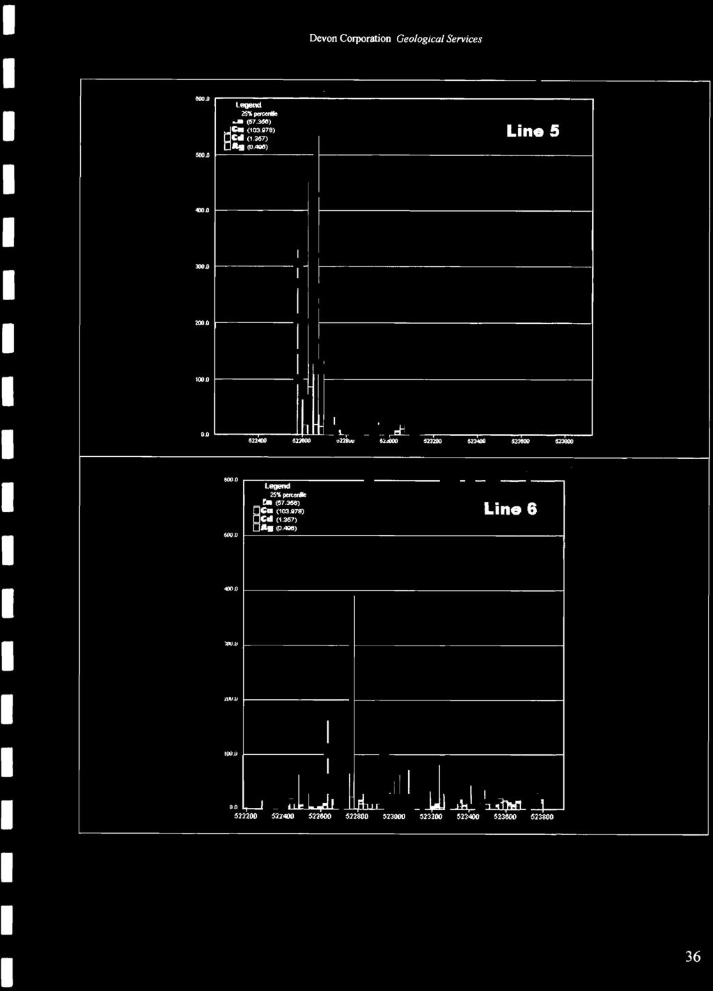
36 MM Response Ratio Line Transects a.o G.o O.D 0.0 G3lOO lagend 25'4 poo:one ~Z.~ ) c. ( ) U (1.267) "(l.~ ='"fl. Devon Corporation Geological Services stacked bars: Multivariate Transect ( Response Ratios).J1 ~~ -c= lOO 51C111O..rfl..F-... L ~ stacked bars: Multivariate Transect ( Response Ratios) 6OO.or-~u.---~~ ' 25""""" (07 > ~z. C. (1roms) Line 2 U(1~ "(l.~ 6OO.o~ ~ 4lO.D r ~ r ~ ~.O~ ~ ~.or_ figure 9 Line 1 ~ 34
 -~ r--~---~----")
.. ~.")


,,(0.")
37 Devon Corporation Geological Services stacked bars: Multivariate Transect r Response Ratios) -~ r--~---~---- ~~ ~--~ ~ ~ =25'4= Ct (1.aG7).. ~.-> Line 3 ~~ ~~ ~~------~ ~ G~ r _.--~------~ ~ loo~ ~ _i.::: _ i 21)1).0 ~ f ~ f Stacked bars: Multivariate Transect ( Response Ratios)...0..ocn ~ == Line 4 Ct (1.aG7),,(0.-> ~'O~--~ ~ _1 0.0 ~ ~ loo.o ~ ~.._ ~.o r r-~~~ ~ 100~ r _.::::;;;;rl /-11/

 200D 'OOJ) OJ) 2S' pen:ono ~z.")

 ~== \"'(O.")
38 ~J) ~ ~ ~J) ~ ~ ~ Devon Corporation Geological Services Stacked bars: Multivariate Transect ( Response Ratios)... l JOOJ) 200D 'OOJ) OJ) 2S' pen:ono ~z. (57~ ) C. (103mS) Ct (1.267)... (O.~.~ " L. 6228GO Line 5 Stacked bars: Multivariate Transect ( Response Ratios OOOJ) ~ Line 6 Ct (1.367) ~== "'(O.~ ~"~ i ~"~ ~~ i.oo»~ ~~~ ~ 36
 ~n~~~-~.----------------------------------------~ 25\".")
 \"(0,-) ~nr-~------------------------------------------~")


39 , Devon Corporation Geological Services stacked bars: Multivariate Transect ( Response Ratios) ~n~~~-~ ~ 25"... ~ =f,o::~ Line 7 U (1.307) "(0,-) ~nr-~ ~ ~D~ ~ ~~~ ~ ~nr ~ loonr ~ stacked bars: Multivariate Transect (Response Ratios) ~nr-~l-~~ ~ ~ =25l= U (1.207) "(0,-) Line 8 ~n~ ~ ~n~ ~ *n~ ~ ~ ~n~ ~ OOD~ ~ ~ The main Zn-Cd-Cu-Ag anomaly on the property starts at the northern boundary, only 500 meters south of the past producer South Bay Mine (figure 7). When plotted against a compilation map filed by Minnova (figure 8), it can be seen quite clearly that this MM anomaly does not follow the strike of the Wasp Zone, but rather parallels it some 200 meters to the west. t would 37


 represents a weak gold zone,")

40 Devon Corporation Geological Services appear that no past drilling has tested this significant MM Zn-Cd-Cu-Ag anomaly fr'ri----f---tl ~ o Scale 1 : figure Confederation Minerals MM soils Au Anomalies The yellow trend (figure 10) represents a weak gold zone, possibly in the hanging wall to the VMS zone. The gold response ratios plotted are generally considered to be low in magnitude. A 38
41 Devon Corporation Geological Services respone ratio of 40 times background, or higher, is often indicative of significant gold mineralization when associated with an oxidizing source. The Tribute-Garnet Lake VMS discovery also reports a gold zone above (hangingwall) the main VMS massive sulphide zone. Recommendations The Confederation Lake Property was considered to be at the early stage exploration level with excellent potential for the discovery of significant VMS base metal mineralization at depths greater than 100 meters below surface. Previous workers believed that the Wasp Zone (figure 8) was possibly a southern extension to the South Bay Mine trend. Historical records report drill intersections in the Wasp Zone up to 2% Zn over 19 meters. These results cannot be verified, and as such cannot be relied upon. The MM Line 5 was intended to cross this zone, but heavy spring flooding rendered the area unsuitable for sampling. The interpretation of the MM data would suggest that 200 meters west of the Wasp Zone is a strong north-south MM Zn-Cd-Cu-Ag anomaly striking from the northern property boundary for approximately 1.8 kms to the south. The projected trend of the South Bay Mine trend VMS mineralization would appear to be present within the area so far surveyed. Additional MM sampling, stripping, trenching, deep penetrating geophysical surveys and exploratory drilling is warranted. The MM soil method would appear to respond well to Zn-Cd-Cu-Ag mineralized trends in the area of this survey. The property remains under explored by modern methods and therefore warrants further exploration Proposed Rolling Phase Budget Phase t: $500,000 review and compile all historic data capture data to a standard digital format enter relevant data into 3D GS-based computer system define VMS-style vectoring and targeting parameters generate property-scale area of interests based on appropriate VMS model Grid 1 to conduct field orientation surveys (completed) cut grid lines as necessary Grid 2 to commence multi-element MM soil surveys in key areas assess results and vector to high priority drill targets, or refine targeting with, deep penetrating geophysical surveys to vector to high priority drill targets First Milestone: Grid 2 has proven successful in identifying high-priority drill targets. 2,000 meters of diamond drilling is warranted 39
42 References Bruce, E.L., 1929 Fyon, A.J. and Lane, L., 1985 Devon Corporation Geological Services Gold deposits of Woman, Narrow and Confederation Lakes, District of Kenora (Patricia Portion). ODM, Annual Report for 1928, 37 pt3 p_ Structural geology and alteration pattems rtllated to gold mineralization in the Confederation Lake artla; n: in Summary of Field WO\1( and Other Activities 1985, OGS. Miscellaneous Paper 126: Fyon, A.J. and O'Donnell, L., 1986 Regional strain state and alteration pattems rtllated to gold mineralization in the Uchi Confederation-Woman lakes artla; in Summary of Field Wor!< and other Activities OGS, Miscellaneous Paper 132: Goodwin, A.M., 1967 Greig, J.W., 1928 Gupta, V.K., & Wadge, D.R, ]980 Gupta, V.K., & Wadge, D.R 1986 Gupta, V.K., & Wadge, D.R Pryslak, A.P., 1970 Pryslak, A.P Volcanic studies in the Birch-Uchi Lakes Area of Ontario. ODM, Miscellaneous Paper 6, 96p. Woman and Narrow Lakes Area, District of Kenora (Patricia Portion). ODM, Annual Report for 1927, 36 pt. 3 p Gravity study of the Birch-Uchi and Red Lakes Artla, District of Kenora (Patricia Portion). OGS, Open File Report 5278, 249p. Gravity study of the Birch, Uchi, and Red Lakes area, District of Kenora (Patricia Portion), Ontario Geological Survey rtport 252, gap. Accompanied by Maps 2492, 2493, 2494 and Scale 1 :250,000. Bouguer gravity, Red Lake-Birch Lake, District of Kenora, Ont. Geol. SUN., Map 2492, Geophysical/Geochemical Series, Scale 1:250,000. Survey 1976,1977. Mitchell Township, District of Kenora (Patricia Portion); ODM, Preliminary- Map P.593. Knott Township, District of Kenora (Patricia Portion); ODM, Preliminary Map P.635. Rogers, N., van Staal, CR, & McNicol!, Recent advances in the geology and structurtl of the Confederation Lake region, V.,999 northwestern Ontario. GSC, Current Research c: Schwerdtner, W.M., Crews, MJ., Structural analysis at the Woman-Confederation assemblage boundary, western Birch- Gaudette, J., Hanley, J.1., Moslehi, H., Uchi Greenstone belt: ProgrtlSS Report.OGS, Miscellaneous Paper 168: Stott, G.M., and Corfu, F., 1991 Thurston, P.C., 1978 Thurston, P.C., 1980 Thurston. P.C., 1985 Thurston, P.C., 1991 Uchi Subprovince; n: Geology of Ontario, OGS, Special volume 4, Part 1, p Geology of the Earngey-Costello Area, District of Kenora (Patricia Portion). OGS, Open File Report 5240: 210p. Subaerial volcanism in the Archean Uchi-Confederation volcanic bah. Precambrian Research, 12: Physical volcanology and stratigraphy of the Confederation Lake area, District of Kenora (Patricia Portion). OGS Report 236: 117p. Accompanied by Map Geology of Ontario: ntroduction. n. Geology of Ontario, Special Volume 4, Part 1, Ontario Geological Survey p Wallace, H., Thurston, P.C., and Corfu, Developments in stratigraphic correlation: Westem Uchi Subprovince; in volcanology and F mineral deposits. OGS, Miscellaneous Paper 129:
43 , Gany K. Smith, P.Geo do hereby certify that: Devon Corporation Geological Services Garry K. Smitb, P.Geo Telephone: (613) CERTllnCATEofAUTHOR 1. am a registered Professional Geoscientist in the Province of Onatrio and President of: Devon Corporation 3267 Stonecrest Rd., RR2 WoodJawn, Ontario Canada KOA3MO 2. [graduated with an honours B.Sc. degree in Earth Sciences from the University of Waterloo in am a registered member of the Association of Professional Geoscientists of Ontario. 4. have worked as a geologist for a total29years since my graduation from university. 5. have read the definition of "qualified person" set out in National nstrument (''N '') and certify that by reason of my education, affiliation with a professional association (as defined in N ) and past relevant work experience, fulfill the requirements to be a "qualified person" for the purposes of this Report 6. am responsible for the preparation of all sections of the technical report titled Confederation Minerals nc, Confederation Lake Proprty, MM Soil Geochemical Survey, and dated July 1, am independent of the issuer applying all of the tests in section 1.5 of National nstrument have read Requirements for Geochemical Reports, and the this Report has been prepared in compliance with Best Practice Guidelines. 9. consent to the filing of this Report for assessment purposes, including electronic publication in the assessment files websites accessible by the public. Dated this st Day of July, for Devon Corporation 41
44 Devon Corporation Geological Services Appendix 1: MM Soil Sample Locations


45 jewta;j W kms Devon Corporation Geological Services Confederation Minerals MM grids r~= Grid 1 was previously filed for Assessment in Grid 2 comprises a single line, Ll, on the Belanger Block, a single line, L2, in the central main Block, and lines L3-L8 at the northernmost boundary of the property. The South Bay Mine is only about 500 meters to the north of the claim boundary.


 1130G4 113e06 l1300c 1138117 113eQ8 113GlK1 113700 113701 113702 113703 113704 1137O!1 11370e \" 113707 113708 113700 113710\" 113752-11375 1--\" 113750 :m~ ~lm.")
 C..10 co en U' C 113eG3 113802 1138111 1138GO 113t18f1 113088 113887 11388e 113885 113884 113883 113882 ll=.")
 113854 1138Ckl c 11385e..10 113857 en 113858 - co m: C/o) 113881 V 113882 113883 113ee4 113885 1138Ge 113Ge7 113888 1130811, v ~.")
46 en Q) o - :l - i - ' o ~118 ~ + _. 3 L " - td Z c: 3 0- td... en n Ci) os::::!. a ~ c. '1:1 CD C;; ylv.., ~ 0-8 ~ = ~ CD f! en ::l :::J < '1:1 r- CD ~'<! CD ~ o c: ::T 0 '" w '" '" w '" o o i..., ,- '- '" a> o co G « l138el 1138eO 11385G ~ 1137G Ckl eO Ge e8 1137e11 J """'" 'm~ tt38-«l M M! ,mm eG ee m 1137G m ~ ~ '" o '" o o 0) 1130G4 113e06 l1300c eQ8 113GlK O! e " " " :m~ ~lm.: l C/o) C..10 co en U' C 113eG GO 113t18f e ll=.t m:~ v (11 C/o) C... CO ~ CO + T '" ~ o,113& M! 113M! 11~7 113M! 113" 113CklO 113eGl 113e G3 C/o) Ckl c 11385e en co m: C/o) V ee Ge 113Ge , v ~.~ '" a> ~ '" o o -,~ ~ C/o) C..10 en CO C/o) C/o) 113e l13eog ~2 11~ G b L; ~ f i g' ~ ~ ~ [ ~ ~ '"


47 ~~~~ Devon Corporation Geological Services + ::=== o M _ iiiiii ; Scale 1: Sample Numbers L Grid 2, South Part MM Soil Survey Confederation Lake Property
48 Devon Corporation Geological Services Appendix 2: MM Assay Certificates
49 To: Devon Corporation Attn: Geologist Garry K. Smith 3267 Stonecrest Rd. RR2 WOODLAWN ONTARO KOA 3MO P.O. No. Project No. No. Of Samples Date Submitted Report Comprises Distribution of unused material: 108 Soils Certificate of Analysis POi: SENNA DEFAULT 108 Jun 05, 2007 Pages 1 to 16 (nclusive of Cover Sheet) Work Order: Certified By SO Accredited for Specific Tests. see No. 456 Date: Jun 20, 2007 Report Footer: L.N.R. :::: Listed not received n.a. :::: Not applicable.s. :::: nsufficient Sample :::: No result *NF = Composition of this sample makes detection impossible by this method M after a result denotes ppb to ppm conversion, % denotes ppm to % conversion Methods marked with an asterisk (e.g. *NAA08V) were subcontracted Subject to SGS General Terms and Conditions The data reported on this certificate of analysis represents the sample submitted to SGS Minerals Services. Reproduction of this analytical report, in full or in part, is prohibited without prior written approval. SGS Canada nc. Min.:..,,:~ Servic:~~885 Lesli,: Street Toronto ON M3B 2M3 t(416) (416) Member of the SGS Group (SOCiete Generale de Surveillance)

50 n Element Method Oet.Lim...""' The data reported on this certificate of analysis represents the sample submitted to SGS Minerals Services Reproduction of this analytical report, in full or in port, ~ proh'~ted _0::::::'.:""''':'.0''' SON." 1885 l."~ Street To~.'" ON M3B 2M3 «416) M 16) Member of tit. SGS Group (SOCiete Gen,,,,,,le de Survellianc.. )
 445-5755 f(416) 445-4152 www.")
51 : Element Method Oet.Lim. The data reported on this certificate of analysis represents the sample submitted to SGS Minerals Services. Reproduction of this analytical report, in full or in part, is prohibited WithO:~~i:~~~;:::pprov:ineral Services ~.~~.~.~::lie Str:.::...::.::.~.::.nto ON ~3B 2M3 t(416) f(416) M.mb.r of the SGS Group (Societe Ge... ral. d. Surv.lllance)
52 The data reported on this certificate of analysis represents the sample submitted to SGS Minerals Services. Reproduction of this analytical report, in full or in part, is prohibited without prior written approval. SGS Canada Mineral Services 1885 leslie Street Toronto ON M3B 2M3 t(416) f(416) Member of the SGS Group (Soc'ete Generale de Surveillance)

53 Element Method <5j Tf359-8-~-->--~ ----~ The dat:"~eport:::n this certificate of analyss represents the sample submitted to SGS Minerals Services. Reproduction of this analytical rep:rt-,-in'-f-ul-1 o... r in part, is prohibited without prior written approval. SGS Canada nc. Mineral Services 1885 Leslie Street Toronto ON M3B 2M3 t(416) f(416) Member of the SGS Group (Societe Generale de Surveillance)

54 ! C:n'''''~ ch, Element Method Oet.Um. 1Units \ ' ~ [ , H13646,,,,,,,~-~.-,~~.~..-,~.-,,~,--, ~he data reporte~~:=~~cate of analysis represents the sample submitted to SGS Minerals servic~reproduction of this analytical report. in full or in part, is prohibited without prior written approval. SGS Canada Services 1885 Leslie Street Toronto ON M3B 2M3 t(416) f(416) Member of the SGS Group (Societe Generale de Surveillance)
55 na : Element Method Oet.Lim. Units _.~_~d~"," '~.',, ~"~~ The data reported on this certificate of analysis represents the sample submitted to SGS Minerals Services. Reproduction of this analytical report, in full or in part, is prohibited without prior written approval. SGS Canada Services 1885 Leslie Street Toronto ON M3B 2M3 t(416) f(416) Member of the SGS Group (Societe Generale d. Surveillance)

56 na! : Element Method Oet.Lim r13562~---'~"~~~'~"-~~~~~-~~~ l ~~~,~-,, ~'~'~-'~~-~~'~--'---~-"~~~' ~~~.:~--~:=:~ !-! ,.~--! ~. The data reported on this certificate of analysis represents the sample submitted to SGS Minerals Services. Reproduction of this analytical report, in full or in part, is prohibited without prior written approval. SGS Canada nc Mineral Services 1885 Leslie Street Toronto ON M3B 2M3 t(416) f(416) Member of the SGS Group (Societe Generale de Surveillance)

57 Fina! : Element Method Det.Lim. <1 <1 <1 The data reported on this certificate of analysis represents the sample submitted to SGS Minerals se':ices. Reproduction of this analytical report, in full or in part, is prohibited without prior written approval. SGS Canada nc. Services 1885 Leslie Street Toronto ON M3B 2M3 t(416) f(416) Member of tlte SGS Group (Societe Gene... le de Surveillance)
58 nal: Element Method <1 <1 < <1 < < The data reported on this certificate of analysis represents the sample submitted to SGS Minerals Services. Reproduction of this analytical report, in full or in part, is prohibited without prior written approval. SGS Canada nc. Mineral Services 1885 Leslie Street Toronto ON M3B 2M3 t(416) f(416) Member of the SGS Group (Societe Generale de Surveillance)

59 na : Element Method The data reported on this certificate of analysis represents the sample submitted to SGS Minerals Services. Reproduction of this analytical report, in full or in part, is prohibited without prior written approval. SGS Canada nc. Mineral Services 1885 Leslie Street Toronto ON M3B 2M3 t(416) (416) Member of the SGS Group (Societe Generale de Surveillance)

60 : Element Method The data reported on this certificate of analysis represen:::e sample submitte~o SGS Minerals Services. Reproduction of this analytical report, in full or in part, is prohibited without prior written approval. SGS Canada Mineral Services 1885 Leslie Street Toronto ON M3B 2M3 t(416) f(416) Member of the SGS Group (Societe Ginerale de Surveillance)
61 : Element Method Det.Lim. The data reported on this certificate of analysis represents the sample submitted to SGS Minerals Services. Reproduction of this analytical report, in full or in, rt, ;,,,,h;b;ted W;lh0 5 ::":::::""''''':;00'''' 5e",'" 1885,,,,;,51,,,.. fmo"o ON MS. 2M3 ~416) M16) _,'9','" Member of the SGS Group (Societe Ge"eral. d. Surveillance)
62 : Page 14 of 16 Element Method 21 L_ -~~ '-- The data reported on this certificate of analysis represents the sample submitted to SGS Minerals Services. Reproduction of this analytical report, in full or in part, is prohibited without prior written approval. SGS Canada Services 1885 Leslie Street Toronto ON M38 2M3 t(41s) '(416) Member of the SGS Group (SOCiete Generale de Survemance)
63 inal : Element Method Oet.Lim. Uniw~,._~~~~~.. ~>~ ~ Page 15 of 16 i ~636 ;113~6~37=--~---'-~'----1F T3638~ '---::d--- The data reported on this certificate of analysis represents the sample submitted to SGS Minerals Services. Reproduction of this analytical report. in full or in part. is prohibited without prior written approval. SGS Canada 1885 Leslie Street Toronto ON M3B 2M3 1(416) f(416) Member of the SGS Group (Societe Generale d. Surveillance)
64 na : Page 16 of 16 Element Method Oet.Lim. Units The data reported on this certificate of analysis represents the sample submitted to SGS Minerals Services. Reproduction of this analytical report, in full or in p." ;s pwh;m,d w"'os::ri:~::;::,:pp'~~;,.",~ Senrioes 1~~.<::'1i' S... To",to ON M3B 2M3 «416) ~'16) 4,'"'152 Member of the SGS Group (Socil.te Generale de Surveillance)
65 Certificate of Analysis Work Order: To: Devon Corporation Date: Jun 20,2007 Attn: Geologist Garry K. Smith 3267 Stonecrest Rd. RR2 WOODLAWN ONTARO KOA 3MO P.O. No. Project No. No. Of Samples Date Submitted Report Comprises Distribution of unused material: 134 Soils PO#: SENNA DEFAULT 134 Jun 05, 2007 Pages 1 to 21 (nclusive of Cover Sheet) Certified By SO Accredited for Specific Tests. sec No. 456 l~'~';~:~~'--'-'~;-~ = Liste~~eceived.a. = nsufficient Sample = No result,s. = Not applicable NF = Composition of this sample makes detection impossible by this method, after a result denotes ppb to ppm conversion, % denotes ppm to % conversion ethods marked with an asterisk (e,g. 'NAA08V) were subcontracted Subject to SGS General Terms and Conditions e data reported on thirtificate of analysis represents the sample submitted to SGS Minerals Services, Reproduction of this analytical report. in full or in part, is prohibited withotof written approval. s'~anada nc, Mineral Services 1885 Leslie Street Toronto ON M38 2M3 1(416) '(416) Member of the SGS Gmun l~ft.,..l_"'* 'H... _~ "~ W'NW.sgs.ca.ftC
 445-5755 f(416) 445-4152 www.sgs.ca Member of the SGS Group (SOCiete General.")
66 B', MM-M 3 The data reported on this certificate of analysis represents the sample submitted to SGS Mineral:services, Reproduction of this analytical report, in full or in part, is prohibited without prior written approval. SGS Canada nc, Mineral Services 1885 Leslie Street Toronto ON M38 2M3 t(416) f(416) Member of the SGS Group (SOCiete General.. de Surveillance)

67 Element Method Det.lim. Units ~~O~_'_' ~ p137~o~~~~~----'------~---f~~~ , ~ ~ ~12~ ~---~----~------~~ --~~--~ --""'"''"~--~-~---..~-~,'''''' The data reported on this certificate of analysis represents the sample submitted to SGS Minerals Services. R~production of this~na~~ical report, in full or in part, is prohibited without prior written approval. SGS Canada nc. Mineral Services 1885 leslie Street Toronto ON M3B 2M3 t(416) f(416) Member of the SGS Grollp (Soc let' Generale de Slrvelllance)

68 : Fin~ Element Method Det.Lim ' The data reported on this certificate of analysis represents the sample submitted to SGS Minerals Services. Reproduction of this analytical report, in full or in part, is prohibited without prior written approval. SGS Canada nc. Mineral Services 1885 Leslie Street Toronto ON M3B 2M3 t(416) f(416) Member of the SGS Group (Soelete Generale de Surveillance)
69 Final: Element Method Det.Lim. Units Dup The data reported on this certificate of analysis represents the sample submitted to SGS Minerals Services. Reproduction of this analytical report. in full or in part. is prohibited without prior written approval. SGS Canada nc. Mineral Services 1885 Leslie Street Toronto ON M3B 2M3 t(416) (416) Member oftlle SOS Group (SOCiete Genera.e de Surveillance)

70 nal : Element Method Oet.Lim ; t~~~~706 ~--:--.==_._,... _.. _ 1 The data reported on this certificate of analysis represents the sample submitted to SGS Minerals Services. Reproduction of this analytical report, in full or in part, is prohibited without prior written approval. SGS Canada nc. Mineral Services 1885 Leslie Street Toronto ON M38 2M3 t(416) f(416) Member of the SGS Group (Sochite Generale de Surveillance)

71 nai: Element Method Oet.Lim. < ~--'----~~- The data reported on this certificate of analysis represents the sample submitted to SGS Minerals Services. Reproduction of this analytical report, in full or in part, is prohibited without prior written approval. SGS Canada nc. Mineral Services 1885 leslie Street Toronto ON M3B 2M3 t(416) f(416) Member of the SGS Group (Societe Generale de Surveillance)

72 : Element Method Det.Lim. Units ~-~----~-- -,~--~~"-~~~~,, 2 The data reported on this certificate of analysis represents the sample submitted to SGS Minerals Services. Reproduction of this analytical report, in full or in part, is prohibited without prior written approval. SGS Canada nc. Mineral Services 1885 Leslie Street Toronto ON M3B 2M3 t(416) f(416) Member of the SGS Group (Socl.te G... ral. de Surveillance)
73 The data reported on this certificate of analysis represents the sample submitted to SGS Minerals Services. Reproduction of this analytical report, in full or in part, is prohibited without prior written approval. SGS Canada nc., Mineral Services 1885 Leslie Street Toronto ON M3B 2M3 t(416) (416) Member of the SGS Group (Societe Generale de Surveillance)

74 ~''W' ~~ ~, G: Element Method Det.Lim. Units r ~ The data reported on this certificate of analysis represents the sample submitted to SGS Minerals Services. Reproduction of this analytical report, in full or in p.rt, - p"hlli'ted W''''::~~:::~:''PP'Oval. 5,,,,,,,,,, 1885 L""'e 5''''''' T 0"",0 ON M3B 2M3 '(416) (416) " Member of the SGS Group (Societe Generale de Sunrelllance)
75 The data reported on this certificate of analysis represents the sample submitted to SGS Minerals Services. Reproduction of this analytical report, in full or in p,rt,,,"'hlbited "'h:::~:~",p"""'1 S."",,, ,~ S"ee T 0","10 ON M3B 2M3 ~4 \6) '(4\6) _."9'."" Member of the SOS Grollp (Societe Generale de Slirveiliance)

76 Element Method Oet.Um. Units fff3ysg-- \ ' ~-+-- ~w~~767 -==~~.~~~..-".. ~, ~~.~-~ ~:! :::-:: ' ",~ ".~".. -..,-.-~-t.-.-~~~- P~ MM.M~ PPB < < The data reported on this certificate of analysis represents the sample submitted to SGS Minerals Services. Reproduction of this analytical report, in full or in part, is prohibited WithO;:~i:~:::::~prov:ineral Services 1885 Leslie Street Toronto ON M38 2M3 t(416} f(416) Member of the SGS Group (Societe Generale de Surveillance)
77 nal : Element Method Oet.Lim. Units The data reported on this certificate of analysis represents the sample submitted to SGS Minerals Services. Reproduction of this analytical report, in full or in part, is prohibited without prior written approval. SGS Canada nc. Mineral Services 1885 Leslie Street Toronto ON M3B 2M3 t(416) f(416) Member of the SGS Group (Societe Gene,.le de Surveillance)

78 : Element Method Det.Lim. 11 The data reported on this certificate of analysis represents the sample submitted to SGS Minerals Services. Reproduction of this analytical report, in full or in part, is prohibited without prior written approval. SGS Canada Mineral Services 1885 Leslie Street Toronto ON M3B 2M3 t(416) (416) Member of the 56S Group (50elete Generale de Surveillance)

79 Element Method Det.Lim. Units ---- ~~--,~ 1 1 Page 15 of ~--~ 7 <1 <1 The data reported on this certificate of analysis represents the sample submitted to SGS Minerals Services. Reproduction of this analytical report, in full or in part, is prohibited without prior written approval. SGS Canada Mineral Services 1885 Leslie Street Toronto ON M3B 2M3 t(416) '(416) Member of the SGS Group (Societe Gene,ale de Surveillance)

80 nal: Element Method Page 16 of 21 The data reported on this certificate of analysis represents the sample submitted to SGS Minerals Services. Reproduction of this analytical report, in full or in part, is prohibited without prior written approval. SGS Canada nc. Mineral Services 1885 Leslie Street Toronto ON M3B 2M3 t(416) f(416) ~--"."""~~~-~"- Member of the SGS Group (Societe Generale de Surveillance)
81 - Fi 0 Element Method Det.Lim. The data reported on this certificate of analysis represents the sample submitted to SGS Minerals Services. Reproduction of this analytical report. in full or in part, is prohibited without prior written approval. SGS Canada nc. Mineral Services 1885 Leslie Street Toronto ON M3B 2M3 t(416) f(416) Member of the SGS Group (Societe Ge.erale de Surveillance)
82 Page 18 of21 )~~'~""~~F~_~"~'_"'_""~""'~" ~~_~~ --'~-+~-'""--~'''--'''"'=~-'~--~ The data reported on this certificate of analysis represents the sample submitted to SGS Minerals Services. Reproduction of this analytical report, in full or in part, is prohibited without prior written approval. SGS Canada nc. Mineral Services 1885 Leslie Street Toronto ON M3B 2M3 1(416) f(416) Member of the SGS Group (Societe General. d. Surveillance)
83 nal : Element Method Oet.Lim. Page 19 of 21 The data reported on this certificate of analysis represents the sample submitted to SGS Minerals Services. Reproduction of this analytical report. in full or in part, is prohibited without prior written approval. SGS Canada Services 1885 Leslie Street Toronto ON M3B 2M3 t(416) f(416) Member of the SGS Group (Societe Ginerale de Surveillance)
84 Page 20 of21 The data reported on this certificate of analysis represents the sample submitted to SGS Minerals Services. Reproduction of this analytical report, in full or in part, is prohibited without prior written approval. SGS Canada Services 1885 Leslie Street Toronto ON M3B 2M3 t(416) (416) Member of the SGS Group (Societe Generala de Surveillance)
85 , Page 21 of 21 ~ement Jlathed oat.lim. Units up up 11379l...~ The data reported on this certtficate of analysis represents the sample submitted to SGS Minerals Services. Reproduction of this analytical report, in full or in part, is prohibited without prior written approval. SGS Canada nc. Mineral Services 1885 Leslie Street Toronto ON M3B 2M3 t(416) f(416) Member of tlte SGS Group (Societe General. d. $ur... llllanc:
86 To: Devon Corporation Attn: Geologist Garry K. Smith 3267 Stonecrest Rd. RR2 WOODLAWN ONTARO KOA 3MO P.O. No. Project No. No. Of Samples Date Submitted Report Comprises Distribution of unused material: 94 Soils Certificate of Analysis PO#: SENNA DEFAULT 94 Jun 05, 2007 Pages 1 to 16 (nclusive of Cover Sheet) Work Order: Date: Jun 25, 2007 Certified By ~. P.a.-~J? _«= Operations Manager SO Accredited for Specific Tests. see No. 456 Report Footer. LN.R = Listed not received n.a. = Not applicable.s. = nsufficient Sample = No result *NF = Composition of this sample makes detection impossible by this method M after a result denotes ppb to ppm conversion, % denotes ppm to % conversion Methods marked with an asterisk (e.g. *NAA08V) were subcontracted Subject to SGS General Terms and Conditions The data reported on this certificate of analysis represents the sample submitted to SGS Minerals Services. Reproduction of this analytical report, in full or in part, is prohibited without prior written approval. SGS Canada nc. Mineral Services 1885 Leslie Street Toronto ON M3B 2M3 t(416) (416) Member of the SGS Group (SOCiete Generale de Surveillance)

87 nal: Element Method Oet.Lim. Units ~~~'~ ~~---~~----~'-~'-"--1-'-----;:l---'--::~--:!----:::::"-----;:~ i4-~---'-~-'--~---t~--'~"':l-""-"~- The data reported on this certificate of analysis represents the sample submitted to SGS Minerals Services. Reproduction of this analytical report, in full or in part, is prohibited without prior written approval. SGS Canada Services 1885 Leslie Street Toronto ON M3B 2M3 t(416) f(416) <1 <1 Member of the SGS Group (Societe Generale de Surveillance)

88 Element Method Oet.lim. Units ) i1138s:r--'~-"---'-" tr13855"~~'-~-"-' '-'+---"-'" ':+' Rf385!r~~---~'~'-' [113857' ----~~"~,-'-: r ~----.-'-'''''--'''''-~---'--''''''':4''''- ~138~! '--""-'~-'-'''''~'' '--'' ~';~;';~'---"-'~-~~-'-'''-~'-~i----'- M1T866"---"'----" ~~.;':::--,.'--~-~'--"~---"'''+.'' ,., ti13869'---~ l~:~3~8=70~~ ,~~-~~4_~-~,.~ ~ ,--~_.--,-,_... ~.-,-+--~, '--'-::,"-""'''-'--0: part, is prohibited witho:::i:~:~::~n:~prov:ineral Services 1885 Leslie Street Toronto ON M3B 2M3 t(416) f(416) The data reported on this certificate of analysis represents the sample submitted to SGS Minerals Services. Reproduction of this analytical report, in full or in 16 Member of the SGS Group (Societe Ginerale de Surveillance)
89 Element Method Det.Lim. Units The data reported on this certificate of analysis represents the sample submitted to SGS Minerals Services. Reproduction of this analytical report, in full or in part, is prohibited With:::ri:~:~~:~ approv:ineral Services 1885 Leslie Street Toronto ON M3B 2M3 t(416) f(416) M.. mber of th.. SG$ Group (Societe Gener... d.. Surv.. lllance)

90 Element Method Oet.Lim. Units ~ <~. ~._. Page 5 of 16 L MM-M : ~-.-'.'---' ;_~-=_w.= i ~~_ <1 14 The data reported on this certificate of analysis represents the sample submitted to SGS Minerals Services. Reproduction of this analytical report, in full or in part, is prohibited without prior written approval. SGS Canada nc< Mineral Services 1885 Leslie Street Toronto ON M3B 2M3 t(416) f(416) Member of the SGS Group (Societe Generale de Surveillance) < < <
 445-5755 f(416) 445-4152 The data reported on this")
91 Element Method Oet.Lim. Units i113841~4 ~ ~ ~~ ~ ~ Page 6 of 16 < part, is prohibited WithO;:~i:~::::~n:PProV:ineral Services 1885 Leslie Street Toronto ON M3B 2M3 t(416) f(416) The data reported on this certificate of analysis represents the sample submitted to SGS Minerals Services. Reproduction of this analytical report, in full or in 134: Member of the SGS Group (Societe G6nerale de Surveillance)
92 inal: Element Method Oet.Lim.,--- The data reported on this certificate of analysis represents the sample submitted to SGS Minerals Services. Reproduction of this analytical report, in full or in part, is prohibited without prior written approval. SGS Canada nc. Mineral Services 1885 Leslie Street Toronto ON M38 2M3 t(416) (416) Member of the SGS Group (Societe Generale de Surveillance)
 445-5755 f(416)")
93 2 The data reported on this certificate of analysis represents the sample submitted to SGS Minerals Services. Reproduction of this analytical report, in full or in part, is prohibited WithO;::i:~:~;:~n:pprov:ineral Services 1885 Leslie Street Toronto ON M3B 2M3 t(416) f(416) Member of the SGS Group (Sochite Generale de Surveillance)
 445-5755 f(416) 445-4152 www.sgs.")
94 Element Method Det.Lim. Units The data reported on this certificate of analysis represents the sample submitted to SGS Minerals Services, Reproduction of this analytical report. in full or in part. is prohibited without prior written approval. SGS Canada nc. Mineral Services 1885 Leslie Street Toronto ON M3B 2M3 t(416) f(416) ~~r Member of the SGS Group (Societe Generale de Surveillance) 15
95 Element Method The data reported on this certificate of analysis represents the sample submitted to SGS Minerals Services. Reproduction of this analytical report, in full or in part, is prohibited without prior written approval. SGS Canada nc. Mineral Services 1885 Leslie Street Toronto ON M3B 2M3 t(416) f(416) Member of the SGS Group (Sociite G6neral. de Survelllanc.)

96 l- Element Method Oet.Lim. Units -'"-~~- 1;1 The data reported on this certificate of analysis represents the sample submitted to SGS Minerals Services. Reproduction of this analytical report, in full or in part, is prohibited without prior written approval. SGS Canada nc. Mineral Services 1885 Leslie Street Toronto ON M3B 2M3 t(416) '(416) Member of the SGS Group (Societe Genera.e de Surveillance)

97 nal: Element Method Oet.Lim. }_,,3'~~~- '113861,----'--'',..,-w''-,.. w--li-- --"www;c'::: '-~-"""-~'W'-~-""'W- ~1,3"w~8:::6.7::,,=::~-~-~"w_. ".w, ~-='-=-= _ "" -.'_'-,~w.,,~.~w-:_++~, The data reported on this certificate of analysis represents the sample submitted to SGS Minerals Services, Reproduction of this analytical report, in full or in part, is prohibited without prior written approval. SGS Canada nc, Mineral Services 1885 Leslie Street Toronto ON M3B 2M3 t(416) f(416) Member of the SGS Group (SOCiete G'lneraJe d. lurvelllane.)
Gold Mineralization Potential in a Wabigoon Subprovince Granite-Greenstone Terrane, International Falls Area, Minnesota
 Gold Mineralization Potential in a Wabigoon Subprovince Granite-Greenstone Terrane, International Falls Area, Minnesota Manitoba Ontario Mn The State of Minnesota is located in the north-central portion
SECOND DRILL HOLE IHAD2 INTERSECTS MINERALIZED TAPLEY HILL FORMATION AND MINERALIZED BASEMENT IRON FORMATION
 Suite 304, 22 St Kilda Road St Kilda Vic 3182 Ph: +61 3 9692 7222; Fax: +61 3 9529 8057 For Immediate Release 14 th September 2007 SECOND DRILL HOLE IHAD2 INTERSECTS MINERALIZED TAPLEY HILL FORMATION AND
Mishi Lake Gold Property Mishibishu Lake Area, Wawa
 Mishi Lake Gold Property Mishibishu Lake Area, Wawa Location, Accessibility, Infrastructure and Local Resources The property is located 40 km west of Wawa, Ontario, in the Mishibishu Lake Area, Sault Ste.
Summary of Rover Metals Geologic Mapping Program at the Up Town Gold Project, Northwest Territories
 October 13, 2017 Summary of Rover Metals Geologic Mapping Program at the Up Town Gold Project, Northwest Territories Vancouver, British Columbia, Canada - Rover Metals Corp., Rover, is pleased to provide
Lands Parcels in IOL CO-20
 Lands Parcels in IOL CO-20 1 CO-20 The Izok Corridor Lupin - multi-million ounce past gold production (3.6 million oz of gold at average grade of 9.3 g/t Au) Approximately 1 million ounces of undeveloped
Elephant Mountain, Alaska Intrusive Related Gold Project July Option to Earn 100%
 Elephant Mountain, Alaska Intrusive Related Gold Project July 2018 Option to Earn 100% CORPORATE Corporate DISCLOSURE Disclosure The information contained herein, while obtained from sources which we believe
State Metallic Minerals Lease Sale Minnesota s Vermilion Gold District
 State Metallic Minerals Lease Sale Minnesota s Vermilion Gold District State Metallic Minerals Lease Sale Notice of Intent Scale 1:100,000 State Metallic Minerals Lease Sale This portion of the lease sale
CSA Mine Observations Applied to the Development of Regional Exploration Models
 CSA Mine Observations Applied to the Development of Regional Exploration Models 1 Introduction Recent work completed by the geology team has resulted in an improved understanding of the CSA mine system
POTENTIAL OF THE DONGWE COPPER GOLD PROJECT
 POTENTIAL OF THE DONGWE COPPER GOLD PROJECT By Nathan Sabao, P.Geo. September 2015 1 TABLE OF CONTENTS Page 1.0 EXECUTIVE SUMMARY 1 2.0 LOCATION 2 3.0 ACCESS 2 4.0 GEOLOGY 3 5.0 PREVIOUS DRILLING 5 6.0
Drill locations for the 2015 program are highlighted in the geology map below.
 2015 Exploration Program The exploration program plan at KSM for 2015 was designed to improve the understanding of block cave targets and support engineering/environmental aspects of development scenarios.
The Cobalt Rainbow. Airborne geophysical maps show that a north trending aeromagnetic high suggests further undiscovered mineralisation.
 The Cobalt Rainbow The property is located on Greenstone Creek, approximately 4.8 kilometres south west of the creek mouth. The property is located about 24 km due west of Campbell River, in the east-central
VECTORING VOLCANOGENIC MASSIVE SULPHIDE MINERALIZATION AT THE RAINDROP ZONE, SNOW LAKE (NTS 63K16), MANITOBA by G.H. Gale
, MANITOBA by G.H. Gale") GS-8 VECTORING VOLCANOGENIC MASSIVE SULPHIDE MINERALIZATION AT THE RAINDROP ZONE, SNOW LAKE (NTS 63K16), MANITOBA by G.H. Gale Gale, G.H. 2002: Vectoring volcanogenic massive sulphide mineralization at
GS-8 VECTORING VOLCANOGENIC MASSIVE SULPHIDE MINERALIZATION AT THE RAINDROP ZONE, SNOW LAKE (NTS 63K16), MANITOBA by G.H. Gale Gale, G.H. 2002: Vectoring volcanogenic massive sulphide mineralization at
COMBINATION OF MMI AND ENZYME LEACH METHODS IN EXPLORATION FOR GOLD IN AN AREA OF THE CANADIAN SHIELD COVERED WITH GLACIAL SEDIMENTS: A CASE STUDY
 COMBINATION OF MMI AND ENZYME LEACH METHODS IN EXPLORATION FOR GOLD IN AN AREA OF THE CANADIAN SHIELD COVERED WITH GLACIAL SEDIMENTS: A CASE STUDY Nadia Yavorskaya 450 Bonner Ave., Winnipeg, MB, Canada
DÉCOUVERTE Positioned for Discovery in James Bay, Quebec. Investor Presentation, January 2018 by Danae Voormeij, MSc, PGeo
 DÉCOUVERTE Positioned for Discovery in James Bay, Quebec Investor Presentation, January 2018 by Danae Voormeij, MSc, PGeo Location Maps and Infrastructure Location: Durango Resources 100% owned Découverte
The MAPLE BAY PROJECT Copper Silver - Gold
 The MAPLE BAY PROJECT Copper Silver - Gold Good grade and tonnage potential within close proximity to Tidewater The Maple Bay Copper Silver Gold Project covers highly favourable geological host rocks of
Sabin Zn-Cu VMS Project. Sturgeon Lake Belt, Ontario
 Sabin Zn-Cu VMS Project Sturgeon Lake Belt, Ontario June 2017 CORPORATE DISCLOSURE Disclaimer The information contained herein, while obtained from sources which we believe are reliable, is not guaranteed
Burchell Lake, A Copper, Gold and Molybdenum Property In Ontario. Corporate Presentation September, 2013
 Burchell Lake, A Copper, Gold and Molybdenum Property In Ontario Corporate Presentation September, 2013 Background Tanager Energy Inc. is a Canadian corporation whose shares are traded on the TSX Venture
Two Gold Properties for Option, Northwestern Ontario
 1 Two Gold Properties for Option, Northwestern Ontario My two grassroots gold exploration properties located about 60-70 km southwest of Pickle Lake, northwestern Ontario. The properties are located near
Detour West Gold Project Technical Overview. April, 2018
 Detour West Gold Project Technical Overview April, 2018 Detour West Project Overview Detour West is a 7,680 hectare property located at the northwest margin of the Abitibi Greenstone Belt, 20 km west of
Magmatic-Hydrothermal Gold Systems in the Archean of Northern Ontario, Canada: Examples of Syenite-Associated and Porphyry-Type Au-(Cu) Deposits
 Deposits") Magmatic-Hydrothermal Gold Systems in the Archean of Northern Ontario, Canada: Examples of Syenite-Associated and Porphyry-Type Au-(Cu) Deposits By Dr. Daniel J. Kontak Department of Earth Sciences Laurentian
Magmatic-Hydrothermal Gold Systems in the Archean of Northern Ontario, Canada: Examples of Syenite-Associated and Porphyry-Type Au-(Cu) Deposits By Dr. Daniel J. Kontak Department of Earth Sciences Laurentian
it AUSIMM COBAR MINING SEMINAR
 Straits Resources Limited it AUSIMM COBAR MINING SEMINAR Brownfields Exploration at Girilambone: Understanding the Mineralised Systems August 2010 Phil Shields / Phil Jones LOCATION TRITTON OPERATIONS
CARIBOO - GRIZZLY ZINC PROJECT
 CARIBOO - GRIZZLY ZINC PROJECT The Grizzly Lake or Cariboo Zinc property straddles the gravel Weldwood 8400 logging road in the Grizzly Lake area about 55 kilometres northeast of Likely. Roads constructed
Advancing High Grade Gold Assets in Red Lake, Ontario
 Advancing High Grade Gold Assets in Red Lake, Ontario Forward Looking Statement Except for historical information contained herein, this presentation may contain forward-looking statements including but
COPPERSTONE RESOURCES AB INTERCEPTS ZONE OF CHALCOPYRITE-ARSENOPYRITE- BORNITE MINERALIZATION AT SVARTLIDEN IN FIRST DEEP DRILLHOLE FROM 720m-810m
 COPPERSTONE RESOURCES AB INTERCEPTS ZONE OF CHALCOPYRITE-ARSENOPYRITE- BORNITE MINERALIZATION AT SVARTLIDEN IN FIRST DEEP DRILLHOLE FROM 720m-810m In mid-january 2017 Copperstone Resource published a geological
McVicar Lake Gold Property Lang Lake Greenstone Belt Ontario. Argo Gold Inc. (ARQ)
") McVicar Lake Gold Property Lang Lake Greenstone Belt Ontario Argo Gold Inc. (ARQ) Forward Looking Statements This presentation may contain forward-looking statements that involve a number of risks and
McVicar Lake Gold Property Lang Lake Greenstone Belt Ontario Argo Gold Inc. (ARQ) Forward Looking Statements This presentation may contain forward-looking statements that involve a number of risks and
Evaluating the Intrusion-Related Model for the Archean Low-Grade, High- Tonnage Côté Gold Au(-Cu) Deposit
 Deposit") Evaluating the Intrusion-Related Model for the Archean Low-Grade, High- Tonnage Côté Gold Au(-Cu) Deposit L.R. Katz, D.J. Kontak, Laurentian University, B. Dubé, V. McNicoll, Geological Survey of Canada
Evaluating the Intrusion-Related Model for the Archean Low-Grade, High- Tonnage Côté Gold Au(-Cu) Deposit L.R. Katz, D.J. Kontak, Laurentian University, B. Dubé, V. McNicoll, Geological Survey of Canada
Geology, Alteration and. Petrogenesis
 The Mutooroo Copper Deposit: Geology, Alteration and Petrogenesis Graham S. Teale Consultant t Andrew T. Price Havilah Resources NL The speaker would like to thank Havilah Resources NL for the opportunity
Yukon Presentation. October 2012
 Yukon Presentation October 2012 Disclaimer This presentation contains forward looking statements. All statements, other than statements of historical fact, included herein, including without limitation,
We are committed to providing accessible customer service. If you need accessible formats or communications supports, please contact us.
 We are committed to providing accessible customer service. If you need accessible formats or communications supports, please contact us. Nous tenons à améliorer l accessibilité des services à la clientèle.
DISCOVERY OF MINERALISED PORPHYRY & MAGNETITE-COPPER-GOLD AT KAMARANGAN
 MEDUSA MINING LIMITED ABN: 60 099 377 849 Unit 7, 11 Preston Street Como WA 6152 PO Box 860 Canning Bridge WA 6153 Telephone: +618-9367 0601 Facsimile: +618-9367 0602 Email: admin@medusamining.com.au Internet:
Homestake /Standby Gold Zone Deep Drilling + Down Hole EM Phase 2 Drilling Q2 2019
 www.mineralmtn.com World s Richest BIF Hosted Gold Belt >62 Million ounce North Americas Largest Supergiant Orogenic Gold Province Homestake District South Dakota, USA TSX-V MMV -OTCQB-MNRLF Homestake
HOWE COPPER MINE PROJECT HIGH GRADE Cu-Ag with Au
 HOWE COPPER MINE PROJECT HIGH GRADE Cu-Ag with Au The Howe Copper Mine property is located approximately 55 kilometres northwest of Vancouver, BC. It is situated at 1431 metres elevation on the eastern
NEWS RELEASE Ocean Park Ventures Identifies Large Multi-Structure Sulfide Mineralized System Trapper Gold Project, British Columbia
 Suite 302 750 West Pender St Vancouver, BC V6C 2T7 Tel: 604-681-0084 Fax: 604-681-0094 www.oceanparkventures.com TSX-V SYMBOL: OCP NEWS RELEASE Ocean Park Ventures Identifies Large Multi-Structure Sulfide
ASX / MEDIA RELEASE 6 MAY MILE SILVER-LEAD-ZINC DISCOVERY; HIGH GRADE SILVER-GOLD IN ROCK CHIPS AT RUBY SILVER
 ASX / MEDIA RELEASE 6 MAY 2011 4-MILE SILVER-LEAD-ZINC DISCOVERY; HIGH GRADE SILVER-GOLD IN ROCK CHIPS AT RUBY SILVER Highlights: Silver-lead-zinc discovery at 4-Mile; mineralisation intersected in all
SQUARE POST PROJECT CHARTERS TOWERS NORTH QUEENSLAND AUSTRALIA
 SQUARE POST PROJECT CHARTERS TOWERS NORTH QUEENSLAND AUSTRALIA Square Post - Summary PROJECT DETAILS - SQUARE POST The Square Post exploration permit (EPM 18510) contains two styles of mineralisation:
SUMMARY REPORT. ESSAR STEEL ALGOMA INC. 105 West Street, Sault Ste. Marie, Ontario, Canada P6A 7B4
 SUMMARY REPORT IRON LAKE PROPERTY Keating and Keating Additional Townships, Ontario, Canada ESSAR STEEL ALGOMA INC. 105 West Street, Sault Ste. Marie, Ontario, Canada P6A 7B4 Date: March 18, 2013 Prepared
Press Release Azimut and Partners announce Drilling Results from Eleonore South Gold Property, James Bay region, Quebec
 For immediate release December 17, 2018 Symbol: AZM. TSX Venture Press Release Azimut and Partners announce Drilling Results from Eleonore South Gold Property, James Bay region, Quebec Longueuil, Quebec
Yukon Presentation. January 2015
 Yukon Presentation January 2015 Disclaimer This presentation contains forward looking statements. All statements, other than statements of historical fact, included herein, including without limitation,
Grassroots Exploration for Gold in Labrador
 Grassroots Exploration for Gold in Labrador Roger Moss, Nikos Explorations Ltd., Shawn Ryan, RyanWood Exploration, John Clarke, GroundTruth Exploration. Mineral Resources Review November 1 st -4 th 2017
New gold discovery in the Paleoproterozoic Mauken greenstone belt
 New gold discovery in the Paleoproterozoic Mauken greenstone belt Mauken greenstone belt The Paleoproterozoic Mauken greenstone belt is situated in an unexplored and untested terrain in Northern Norway.
EXPLOR INTERSECTS MULTIPLE COPPER ZONES GRADES UP TO 3.65% CU OVER 5.35 METERS ON THE CHESTER COPPER PROPERTY
 15 Gamble East Street - Suite 204 - Rouyn-Noranda (Canada) J9X 3B6 Listing (TSX-V = EXS) (OTCQB = EXSFF) (FSE & BE = E1H1) EXPLOR INTERSECTS MULTIPLE COPPER ZONES GRADES UP TO 3.65% CU OVER 5.35 METERS
TSX.V: RG OTC-PK: RMIOF FRANKFURT: D4R. Lundmark-Akow Lake Project: A new Cu-Au-Ag Massive Sulphide Discovery in NW Ontario
 TSX.V: RG OTC-PK: RMIOF FRANKFURT: D4R Lundmark-Akow Lake Project: A new Cu-Au-Ag Massive Sulphide Discovery in NW Ontario Tel: (416) 221-4124 Fax: (416) 218-9772 E-mail: romios@romios.com Web: www.romios.com
ASSESSMENT REPORT ON THE PEAVINE PROJECT. DGW & Associates # Alberni Street, Vancouver, British Columbia, V6E 4V2
 ASSESSMENT REPORT ON THE PEAVINE PROJECT KAMLOOPS MINING DIVISION BRITISH COLUMBIA NTS 082M 12 Latitude 51 36' 19.0"North -- Longitude --119 47' 27.0"West UTM Zone 11, NAD 83 5720827N 306744E Prepared
LOS AZULES April 2018
 April 2018 lies along the southern extensions of the highly productive Paleocene Mineral Belt in northern Chile that contains numerous important copper, gold and silver mines and projects, and to the south
Discovering Canadian Gold and Diamonds. Oxford Lake Project, Manitoba
 Discovering Canadian Gold and Diamonds Oxford Lake Project, Manitoba March 2016 Forward Looking Statement Certain statements contained in this presentation may contain forward-looking information within
Mountain Maid Gold System Displays Major Size Potential
 29 July 2008 The Manager, Companies Australian Securities Exchange Ltd Electronic Announcement System Dear Sir, AXIOM MINING LIMITED (ASX CODE: AVQ) ASX Announcement Mountain Maid Gold System Displays
2014 AEROQUEST AIRBORNE HELI-BORNE VTEM PLUS AND HORIZONTAL MAGNETIC GRADIOMETER SURVEY ASSESSMENT REPORT CAMERON GOLD PROJECT
 2014 AEROQUEST AIRBORNE HELI-BORNE VTEM PLUS AND HORIZONTAL MAGNETIC GRADIOMETER SURVEY ASSESSMENT REPORT CAMERON GOLD PROJECT PREPARED BY: Nick Walker. January 2015 SUMMARY This report presents the results
ESKAY CREEK MINE. Rob Boyce, P. Geo. G\GROUP\GEOLOGY\EXPLORE\EXPL2001\BUDSAN1
 ESKAY CREEK MINE Rob Boyce, P. Geo. G\GROUP\GEOLOGY\EXPLORE\EXPL2001\BUDSAN1 Outline Location Geology Production Recent Exploration Future of Eskay Creek Location and Transportation From Kitwanga Ore and
COAU PROPERTY LEMHI COUNTY, IDAHO
 COAU PROPERTY LEMHI COUNTY, IDAHO Utah Mineral Resources 447 N 300 W, Suite 3 Kaysville, UT 84037 (801) 544-3421 ojgatten@nae-xploration.com Prepared by: North American Mine Services, LLC. March 21, 2017
New geologic mapping + and associated economic potential on northern Hall Peninsula, Baffin Island, Nunavut
 New geologic mapping + and associated economic potential on northern Hall Peninsula, Baffin Island, Nunavut Holly Steenkamp, M.Sc. Regional Mapping Geoscientist David Mate, M.Sc. Chief Geologist November
Dalradian Reports Regional Gold and Base Metal Targets for the Tyrone Project. Drill Rig 6 Arrives to Start Scout Drilling Program
 2011 No. 11 TSX: DNA, DNA.WT Dalradian Reports Regional Gold and Base Metal Targets for the Tyrone Project. Drill Rig 6 Arrives to Start Scout Drilling Program TORONTO, ONTARIO - (Marketwire - July 28,
For personal use only
 22 April 2013 Drilling to commence at Majada, Copper-Gold Prospect, Chile. Red Gum Resources Limited (ASX: RGX, Red Gum or the Company ) is pleased to announce that drilling of its Majada Copper-Gold Prospect,
ASX Announcement. 28 January Drill results indicate large Porphyry Copper Gold System at Peenam
 ASX Announcement 28 January 2010 Drill results indicate large Porphyry Copper Gold System at Peenam Highlights: 270 metres of visible copper (gold) mineralisation in first diamond core hole at Peenam Prospect
Prospecting Report 'S Office i DB Property, B.C. -J Negro Creek Nelson Mining District NTS 82F.050. Operator: Kootenay Gold Inc.
 . '.' I"' i9 12 Prospecting Report 'S Office i DB Property, B.C. -J Negro Creek Nelson Mining District NTS 82F.050 Operator: Kootenay Gold Inc. Owner: Darlene Lavoie Work Performed Summer of 2007 Report
JOSH LEIGH Project Exploration Geologist June ASX Code AIV
 COALSTOUN AND BOOUBYJAN Porphyry Copper-Gold Complexes, their structural setting, geology and geochemistry Joshua Leigh 1, Doug Young 2, Jose Veracruz 3, Paul Ashley 3 - ( 1 ActivEX Limited, 2 Consultant,
SILVER CITY MINERALS LIMITED ABN Silver City Minerals
 ABN 68 130 933 309 ASX Code: SCI Silver City Minerals Annual General Meeting 20 November 2014 SILVER CITY MINERALS SNAPSHOT BROKEN HILL (Ag-Pb-Zn) Project Review and Prioritization: Focus and Plan Razorback
Rubicon Minerals Corporation. Physical Work Submission Report June, RED LAKE PROPERTY MECHANICAL STRIPPING South Pipestone Bay
 Rubicon Minerals Corporation Physical Work Submission Report June, 2001 RED LAKE PROPERTY MECHANICAL STRIPPING South Pipestone Bay Ball Township Red Lake Mining Division NTS 52/N4 2.216 A /^ r--^'^-, t'n
MORE HIGH-GRADE GOLD INTERSECTIONS FROM CITADEL S SHAYBAN PROJECT, SAUDI ARABIA
 Citadel Resource Group Limited ASX Release 7th July 2009 MORE HIGH-GRADE GOLD INTERSECTIONS FROM CITADEL S SHAYBAN PROJECT, SAUDI ARABIA Highlights: LATEST RC IN-FILL AND EXTENSIONAL DRILLING CONTINUES
MINERAL MOUNTAIN CONFIRMS PROOF OF CONCEPT IN THE HOMESTAKE GOLD BELT
 MMV-TSX.V MNRLF-OTCQX News Release NR 2018 06 May 3, 2018 MINERAL MOUNTAIN CONFIRMS PROOF OF CONCEPT IN THE HOMESTAKE GOLD BELT STANDBY DRILLING RESULTS HAS IDENTIFIED A CLASSIC HOMESTAKE-STYLE, ALTERED
Project 81. Drill Ready Geophysical Targets & Trends. Timmins-Cochrane Northern Ontario Canada
 Project 81 Drill Ready Geophysical Targets & Trends Timmins-Cochrane Northern Ontario Canada FORWARD-LOOKING STATEMENT Certain statements contained in this presentation that are forwardlooking in nature
MINERAL MOUNTAIN RESOURCES LTD. MMV.TSX-V
 MINERAL MOUNTAIN RESOURCES LTD. 201-1416 West 8 th Avenue Vancouver, B.C. V6H 1E1 T: 604-714-0111 F: 604-714-1119 MMV.TSX-V NEWS RELEASE March 3, 2011 No. 2011-04 MINERAL MOUNTAIN DRILLS 3.17 g/t OVER
Aureus Mining New Liberty Project Geology
 Aureus Mining New Liberty Project Geology February 2014 Contents Location and Regional context Deposit geology Resources and Reserves Grade Control Underground potential Near-mine exploration potential
ASSESSMENT REPORT PROSPECTING PROGRAM ION/DIRTY JACK PROPERTY NELSON MINING DIVISION N.T.S. MAP SHEET 82F.023 UTM COORDINATES N E
 ASSESSMENT REPORT PROSPECTING PROGRAM ION/DIRTY JACK PROPERTY NELSON MINING DIVISION N.T.S. MAP SHEET 82F.023 UTM COORDINATES 5454800N - 0455235E Work Performed Summer 2007 OWNER >* ' Tom Kennedy >8 404-22
INTRODUCTION REGIONAL GEOLOGY. N. St-Jean 1, L. Hunt 1 and R.L. Sherlock 1
 37. Preliminary Results from Mapping a New Exposure of the Basal Unconformity Between the Hearst and Larder Lake Assemblages, Skead Township, Northeastern Ontario N. St-Jean 1, L. Hunt 1 and R.L. Sherlock
MINERAL DEPOSITS OF THE COBAR BASIN
 MINERAL DEPOSITS OF THE COBAR BASIN 360 hard rock deposits in Cobar Basin Cu, Au, Ag, Pb, Zn combinations and quartz-au veins Cobar 23 major deposits in Cobar Basin World class Endeavor mine World class
Exploring in the last frontier: Skarn mineralisation, Attunga District, NSW
 BROVEY MAPPING SERVICES Exploring in the last frontier: Skarn mineralisation, Attunga District, NSW Latest exploration findings and interpretations Nancy Vickery, Joshua Leigh and Michael Oates Outline
Características e Critérios da Exploração de Depósitos Orogenéticos de Ouro
 Características e Critérios da Exploração de Depósitos Orogenéticos de Ouro Richard Goldfarb, goldfarb@usgs.gov, SIMEXMIN 2012 Archean Lode Gold Deposits Greenstone Belts in granitoid-greenstone terranes
BALMORAL ANNOUNCES SIGNIFICANT GOLD DISCOVERY ON DETOUR GOLD TREND IN QUEBEC
 TSXV: BAR July 7, 2011 For Immediate Release NR11-14 BALMORAL ANNOUNCES SIGNIFICANT GOLD DISCOVERY ON DETOUR GOLD TREND IN QUEBEC INTERSECTS 6.15 g/t GOLD OVER 4.04 METRES AND 4.18 g/t GOLD OVER 5.00 METRES
Serengeti Resources Inc GEOCHEMICAL REPORT ON THE SHADOW PROPERTY a.
 Serengeti Resources Inc. 2004 GEOCHEMICAL REPORT ON THE SHADOW PROPERTY a. Located in the Johanson Lake Area Omenica Mining Division NTS 94D/9 6 degrees and 32 minutes North Latitude 126 degrees and 2
TECHNICAL REPORT ON THE BLACK CREEK PROPERTY FOR CARRIE ARRAN RESOURCES BLACK TOWNSHIP LARDER LAKE MINING DIVISION ONTARIO
 TECHNICAL REPORT ON THE BLACK CREEK PROPERTY FOR CARRIE ARRAN RESOURCES BLACK TOWNSHIP LARDER LAKE MINING DIVISION ONTARIO B.J. McKay, 8 February 2011 Keewatin, Ontario TECHNICAL REPORT BJML 2011 Table
Copper Reef to Drill Massive Sulphide Targets in Flin Flon
 12 Mitchell Road Tel: (204) 687-3500 Flin Flon, MB, R8A 1N1 CZC.CSE Fax: (204) 687-4762 copperreef.com February 28, 2019. Copper Reef to Drill Massive Sulphide Targets in Flin Flon Copper Reef Mining Corporation
NEW HAZELTON, OMINECA M.D.,
 PROSPECTING REPORT JUDI 1 TO 6 MINERAL CLAIMS NEW HAZELTON, OMINECA M.D., B.C. MAP 93M/4E, LAT. SS014'N, LONG. 127'33'W OWNED BY: A. L'ORSA ANTHONY L'ORSA Smithers, B.C. 21 February, 1981 TABLE OF CONTENTS
GROWTH OPTIMIZATION INNOVATION PEOPLE
 Bulgaria Brownfields Exploration: Krumovgrad DPM Exploration April 3, 2015 Kupel North GROWTH OPTIMIZATION INNOVATION PEOPLE Forward Looking Statements This presentation contains forward looking information
RECONNAISSANCE AND SOIL GEOCHEMICAL SAMPLING REPORT PORCUPINE MINING DIVISION ON CLAIM , LANGMUIR TOWNSHIP
 RECONNAISSANCE AND SOIL GEOCHEMICAL SAMPLING REPORT ON CLAIM 1224499, LANGMUIR TOWNSHIP PORCUPINE MINING DIVISION CLM 1224499 NTS: 42A/06 Author: William Randall, P.Geo 1 Table of Contents Work Performed
NEWS RELEASE FOR IMMEDIATE RELEASE: MARCH 5, 2018
 NEWS RELEASE FOR IMMEDIATE RELEASE: MARCH 5, 2018 Eskay Mining provides update on ongoing geological review - Targeting E&L-Type Nickel-Copper-PGE and Eskay-Type VMS Potential on Its Golden Triangle Holdings:
Total Magnetic Field and VLF Surveys on the Swayze Property. Claim Swayze Township. Porcupine Mining Division
 1 January, 016 NTS: 041 O 15 Total Magnetic Field and VLF Surveys on the Swayze Property Claim 475471 Swayze Township Porcupine Mining Division 380850E, 599450N UTM Z17N NAD83 Report Prepared for: 540
NEWS RELEASE CANADIAN ZINC REPORTS REMAINING DRILL RESULTS AT LEMARCHANT DEPOSIT, SOUTH TALLY POND PROJECT, NEWFOUNDLAND
 NEWS RELEASE CZN-TSX CZICF-OTCQB FOR IMMEDIATE RELEASE March 5, 2018 CANADIAN ZINC REPORTS REMAINING DRILL RESULTS AT LEMARCHANT DEPOSIT, SOUTH TALLY POND PROJECT, NEWFOUNDLAND 2017 drill program successfully
2) the identification through recent mapping of a Brucejack-style conceptual exploration target on its North Mitchell block; and
 the identification through recent mapping of a Brucejack-style conceptual exploration target on its North Mitchell block; and") NEWS RELEASE FOR IMMEDIATE RELEASE: JANUARY 19, 2018 Eskay Mining Corp. Announces 2018 Plans: Ni-Cu-Co Potential Along Red Lightning Trend toward Garibaldi s E&L Occurrence; Potential for Brucejack-Style
NEWS RELEASE FOR IMMEDIATE RELEASE: JANUARY 19, 2018 Eskay Mining Corp. Announces 2018 Plans: Ni-Cu-Co Potential Along Red Lightning Trend toward Garibaldi s E&L Occurrence; Potential for Brucejack-Style
Tin Mineralisation. in the Mesoproterozoic Prospect Hill Region, Northern Flinders Ranges: Recent Drilling Results and Suggestions for Regional
 Tin Mineralisation in the Mesoproterozoic Prospect Hill Region, Northern Flinders Ranges: Recent Drilling Results and Suggestions for Regional Tin Exploration in South Australia UNCOVER CURNAMONA 2017
Figure 1. Location of Boreal s Key Projects
 Boreal Completes Surface IP Geophysics At Burfjord, Norway Vancouver, B.C., January 4, 2018. Boreal Metals Corp. ( Boreal or the Company ) (TSXV:BMX) is pleased to announce the results of an Induced Polarization
Sotkamo Silver Mo i Rana and Tampere areas. Erkki Kuronen Chief Geologist, M.Sc., MAusIMM Sotkamo Silver Oy
 Mo i Rana and Tampere areas Erkki Kuronen Chief Geologist, M.Sc., MAusIMM Oy Mo i Rana and Tampere areas Erkki Kuronen Chief Geologist, M.Sc., MAusIMM Oy 2.9.2018 Silver 2 Deposits and Projects develops
Great Atlantic Rock Samples Return up to 5.8 oz. / ton Gold Golden Promise Property in Central Newfoundland
 Great Atlantic Rock Samples Return up to 5.8 oz. / ton Gold Golden Promise Property in Central Newfoundland FOCUSED ON EXPLORING ATLANTIC CANADA (TSXV : GR) (FRA: PH01) VANCOUVER, British Columbia August
Rich Saddle North Au-Cu-Ag Porphyry Expands by 275m Along Strike and 250m Down-Dip
 GT Gold Drills 281 Metres of 0.65 g/t Au, 0.38% Cu, 1.38 g/t Ag (1.24 g/t AuEq 1 ) Within 685 Metres 2 of 0.40 g/t Au, 0.26% Cu, 1.03 g/t Ag (0.81 g/t AuEq) in Step-out Hole TTD098 Rich Saddle North Au-Cu-Ag
For personal use only
 ASX ANNOUNCEMENT ASX: IVG Date: 30 April 2012 Number: 030_300412 MARCH 2012 QUARTERLY REPORT SUMMARY Market Cap A$2.23m ($0.062 p/s) Issued Capital 36,006,006 Assay data and mineral alteration studies
2013 GEOLOGICAL ASSESSMENT REPORT SHERIDAN HILL PROPERTY
 2013 GEOLOGICAL ASSESSMENT REPORT ON THE SHERIDAN HILL PROPERTY NEW WESTMINSTER MINING DIVISION BRITISH COLUMBIA NTS 092G07 49 16 31 NORTH LATITUDE, 122 39 48 WEST LONGITUDE PREPARED FOR Sheridan Hill
NEWS RELEASE. Evrim and Harvest Gold Complete Drilling at Cerro Cascaron
 910-850 WEST HASTINGS ST. VANCOUVER, BC, CANADA V6C 1E1 TEL: 604.248.8648 FAX: 604.248.8663 WWW.EVRIMRESOURCES.COM TSX-V: EVM CONTACT: PADDY NICOL OR CHARLES FUNK NEWS RELEASE Evrim and Harvest Gold Complete
Pahtavaara Drill Program Intersects 32.8 G/T Gold Over 2.0M And 2.1 G/T Gold Over 18.0M In The Karoliina Zone
 Page 1 of 6 a Pahtavaara Drill Program Intersects 32.8 G/T Gold Over 2.0M And 2.1 G/T Gold Over 18.0M In The Karoliina Zone Jan 11, 2017 Toronto, Ontario, Canada Listed: RUP-TSX-V January 10, 2017 Rupert
Introduction to Prospecting. Session Four Ore Deposits
 Introduction to Prospecting Session Four Ore Deposits Ore Deposits What is ore? Common elements such as gold, copper, zinc and lead occur naturally in all rocks, however in very low quantities. Ore is
Queenston intersects Contact Zone on the Pandora Property and new gold zones in Kirkland Lake
 1 Queenston intersects Contact Zone on the Pandora Property and new gold zones in Kirkland Lake TORONTO, Ontario, March 7, 2003. Queenston Mining Inc. (QMI-TSX) reports diamond drill results on its 100%
A New Direction. Copper-Gold Deposit at Thor TSX.V:COL. August 11, May 2013
 A New Direction Copper-Gold Deposit at Thor August 11, 2016 May 2013 TSX.V:COL FORWARD LOOKING STATEMENTS This presentation includes certain forward-looking information or forward-looking statements for
Anthill Resources Yukon - An Update on the Einarson Project
 Anthill Resources Yukon - An Update on the Einarson Project The Eastern Extension of a Carlin-type Gold Trend in the Selwyn Basin Anthill Resources Ltd Yukon Claim Holdings Over 2400 km 2 Property Location
Drake Resources Limited Quarterly Activity Report June 2007
 Drake Resources Limited Quarterly Activity Report June 2007 HIGHLIGHTS New projects and targets continue to be identified in the Zinifex-Drake base metal alliance in Sweden, Canada and Australia With the
For personal use only
 ABN: 82 138 358 728 ASX: TMZ Level 1, 80 Chandos Street, St Leonards, NSW 2065 PO Box 956, Crows Nest, NSW 1585 Tel: +61 2 9906 6225 Fax: +61 2 9906 5233 Web: www.thomsonresources.com.au Quarter ending
Alcoutim Cu-Zn Portugal Drilling and Technical Update
 4 July 2017 Market Announcements Platform ASX Limited Exchange Centre 20 Bridge Street Sydney NSW 2000 Alcoutim Cu-Zn Portugal Drilling and Technical Update Highlights Access to historical data and drilling
NEWS RELEASE. Evrim announces additional drilling results at Cuale Gold Project in Mexico
 910-850 WEST HASTINGS ST. VANCOUVER, BC, CANADA V6C 1E1 TEL: 604.248.8648 FAX: 604.248.8663 WWW.EVRIMRESOURCES.COM TSX-V: EVM CONTACT: PADDY NICOL OR CHARLES FUNK NEWS RELEASE Evrim announces additional
ARGENTINE FRONTIER RESOURCES INC (AFRI) SALTA EXPLORACIONES SA (SESA)
 SALTA EXPLORACIONES SA (SESA)") ARGENTINE FRONTIER RESOURCES INC (AFRI) SALTA EXPLORACIONES SA (SESA) LA SARITA IOCG-Porphyry Copper-Gold August 2006 La Sarita Cateo 2 La Sarita - bleached center is Taca Taca Arriba. The hematite zone
ARGENTINE FRONTIER RESOURCES INC (AFRI) SALTA EXPLORACIONES SA (SESA) LA SARITA IOCG-Porphyry Copper-Gold August 2006 La Sarita Cateo 2 La Sarita - bleached center is Taca Taca Arriba. The hematite zone
PROSPECTORS ASSISTANCE PROGRAM MINISTRY OF ENERGY AND MINES
 BRITISH COLUMBIA PROSPECTORS ASSISTANCE PROGRAM MINISTRY OF ENERGY AND MINES GEOLOGICAL SURVEY BRANCH PROGRAM YEAR: 1999/2000 REPORT #: PAP 99-l 6 NAME: KIM ANSCHETZ PROSPECTORS TlEPORT on the 99 LOUIS
Geochemistry & mineralogy of late-metamorphic shear zones:
 Geochemistry & mineralogy of late-metamorphic shear zones: Disseminated gold in the Otago Schist, New Zealand Dave Craw Geology Department University of Otago Dunedin, NZ in collaboration with: D.J. MacKenzie,
Reconnaissance. Of the. Denis mineral claims. Situated at Kilometer 844 of the Alaska Highway. Liard Mining Division. Northeastern British Columbia
 Reconnaissance Of the Denis mineral claims Situated at Kilometer 844 of the Alaska Highway Liard Mining Division Northeastern British Columbia N.T.S. 94M.075 Latitude 59 42 25 Longitude 127 13 12 Field
Observations on a Veined Section of Core Drilled at Blockhouse, Lunenburg County
 Report of Activities 2016-17 53 Observations on a Veined Section of Core Drilled at Blockhouse, Lunenburg County R. F. Mills and A. MacKay 1 The Blockhouse gold district (NTS 21A/08) lies approximately