Revision of the Conceptual Model for the Olkaria Geothermal System, Kenya
|
|
|
- Scott Marsh
- 5 years ago
- Views:
Transcription
1 PROCEEDINGS, 42nd Workshop on Geothermal Reservoir Engineering Stanford University, Stanford, California, February 13-15, 2017 SGP-TR-212 Revision of the Conceptual Model for the Olkaria Geothermal System, Kenya Gudni Axelsson 1),2), Valdís Gudmundsdóttir 1), Andri Arnaldsson 3), Halldór Ármannsson 1), Knútur Árnason 1), Gunnlaugur M. Einarsson 1), Hjalti Franzson 1), Saeunn Halldórsdóttir 1), Gylfi Páll Hersir 1), Kennedy Kamunya 4), Vincent Koech 4), Urbanus Mbithi 4), Felix Mwarania 4), Steinthór Níelsson 1), Joyce Okoo 4), Ammon Omiti 4), Peter Ouma 4), Finnbogi Óskarsson 1), Eric Rob 4), Daniel Saitet 4) and Ruth Wamalwa 4) 1) Iceland GeoSurvey (ÍSOR), Grensásvegur 9, 108 Reykjavík, Iceland 2) University of Iceland, Saemundargata 1, 101 Reykjavík, Iceland 3) Vatnaskil Consulting Engineers, Sídumúla 28, 108 Reykjavík 4) Kenya Electric Generating Company (), P.O. Box 785, Naivasha, Kenya Keywords: Olkaria, exploration, drilling, temperature model, conceptual model, management ABSTRACT Olkaria is an unusually large and powerful geothermal system located inside the East African Rift Zone, about 100 km WNW of Nairobi, the capital of Kenya. It is situated inside a major volcanic complex that is associated with a buried caldera and cut by N-S trending normal rifting faults and other major faults and fractures. The Olkaria system is presently under intense development with the electrical generating capacity having increased from about 200 MW e in 2010 to more than 670 MW e at the end of This development has been dominated by Kenya Electric Generating Company () in its 204 km 2 license area. Utilization in Olkaria started when the Olkaria I power station (45 MW e ) was commissioned in the 1980 s, while the Olkaria II power station (105 MW e ) was not commissioned until the early 21 st century. In 2007 drilling of deeper wells (to about 3000 m), in an extended area, identified a much larger and more widespread resource than was previously believed to exist. Extensive drilling since then (about 165 deep wells) has been the basis of the intense development for electricity generation in recent years. The conceptual model of the Olkaria geothermal system has been under constant revision in recent years based on available geological- and geophysical information, temperature- and pressure data, various reservoir testing and monitoring data as well as information on the chemical content of reservoir fluids. Most important are the comprehensive data from the new wells drilled in the area since At least three deep magmatic heat sources are assumed in the system with hot water up-flows into the four main well fields. Comprehensive management is essential for the successful future utilization of the Olkaria geothermal system; including monitoring, reinjection, research and modelling as well as environmental and social awareness. Further exploration of the parts of s license area where exploration has been limited is essential before they will be considered for further development. 1. INTRODUCTION The Olkaria geothermal resource is located in the Kenya Rift valley, about 120 km from Nairobi. Geothermal activity is widespread in the Kenyan rift, with 14 major geothermal prospects having been identified (Fig. 1). The Olkaria geothermal field is inside a major volcanic complex cut by N-S trending normal rifting faults. It is characterized by numerous volcanic rhyolitic domes, some of which form a ring structure, which has been interpreted as indicating the presence of a buried volcanic caldera (Fig. 2). Olkaria is an unusually large and powerful geothermal system. It is surrounded by further geothermal prospects, as shown in Fig. 1. Exploration of the Olkaria geothermal resource started in 1956 with deep drilling commencing in A feasibility study in 1976 indicated that development of the geothermal resource was feasible and consequently the 45 MW e Olkaria I power plant was constructed (Ouma, 2010). It consists of three units commissioned between 1981 and The next 15 years development was limited, but it picked up pace after 2000 with the construction of Olkaria III and later Olkaria II. The development of Olkaria has been most intense after 2007, first through a major drilling campaign (about 165 wells) and later through the construction of more power plants. The drilling of deeper wells (to about 3000 m), in an extended area, has led to the identification of a much larger and more widespread resource than was previously believed to exist. Table 1 summarizes the development history of the Olkaria geothermal system. Five power plants are currently installed in the field producing electricity; Olkaria I with 45 MW e capacity, Olkaria II with 105 MW e capacity, Olkaria III with 140 MW e capacity, Olkaria IV with 150 MW e capacity and a 150 MW e expansion of Olkaria I (units 4 and 5), which recently came on line. Olkaria I, II, IV and units 4 and 5 of Olkaria I are operated by while Olkaria III is operated by OrPower-4 Inc. The parts of the Olkaria geothermal field being utilized or under development have been subdivided into sectors that include Olkaria East (Olkaria I), Olkaria Northeast (Olkaria II), Olkaria West (Olkaria III) and Olkaria Domes (Olkaria IV). Fig. 2 shows the location of the power plants and Fig. 3 shows the location of wells drilled in the field up to the middle of s licence area in Olkaria covers 204 km 2. The Olkaria II power plant, consisting of three units, was commissioned between 2003 and The Olkaria III power plant was commissioned in two phases between 2000 and 2009 and has, furthermore, been under expansion since The Olkaria IV power plant was commissioned in September 2014, and the expansion of Olkaria I came on line in two steps, towards the end of 2014 and in 1
2 early In addition, also operates several well-head units at a combined capacity of about 80 MW e, having started their installation in The combined generation capacity in Olkaria is, therefore, a little over 670 MW e at present. Finally, the geothermal resources of the NW part of the Olkaria area are utilized both for direct heat (50 hectares of greenhouses) and small-scale electricity generation by the Oserian flower farm. Figure 1: Map showing the location of the Greater Olkaria Geothermal Area within the Great Rift Valley of Kenya. Also shown are other volcanic and geothermal centres (Ofwona, 2010). The development ongoing the last decade has mainly been based on s assessment of the capacity of the Olkaria geothermal resources, which in turn is based on the success of drilling operations since 2007, as well as on independent assessments performed by s advisors. These include work conducted by an Icelandic consortium composed of Mannvit hf, ÍSOR, Vatnaskil ehf and Verkís hf. Firstly, a comprehensive optimization study performed during and, secondly, a model maintenance project carried out during Both of these projects have involved the development or revision of the conceptual model of the Olkaria geothermal system, followed by the assessment of the system s capacity through the development of a complex numerical model of the system. Table 1: Development history of the Olkaria geothermal resources. Year present present Exploration starts Deep drilling starts Favourable feasibility study Olkaria I (East) Olkaria III (West) Olkaria II (Northeast) About 165 deep wells drilled Olkaria IV (Domes) Olkaria I additional units 4 and 5 Well-head units Direct use + small scale electrical generation Total 2 Capacity (MW e ) MW e Operator OrPower-4 Oserian

3 Figure 2: Map showing s geothermal concession area in the Olkaria volcanic complex, extending up to Lake Naivasha. The map also shows some of the main geological features of the area and the power plants in operation today. Figure 3: Map showing the location of wells in Olkaria drilled by up to mid 2016, horizontal trajectories of directionally drilled wells shown by red lines. The map covers s concession area, whilst OrPower-4 s concession can be seen on the left (Olkaria III). Only wells drilled by are shown, but not a number of wells drilled in recent years by OrPower-4 Inc. 3
4 Axelsson et al. (2013) describe the conceptual model of the Olkaria geothermal system developed during the optimization study referred to above. They, furthermore, present the results of different assessments made of the electrical generation capacity in the same study, including the outcome of numerical modelling. The numerical model involved is the largest, and most comprehensive numerical model developed for the Olkaria geothermal system up to now. The present paper is a follow-up to that paper presenting the results of the revision of the conceptual model during the model maintenance project. That project also involved a revision of the earlier numerical model, the results of which await later publication. The data and results presented below largely stem from internal reports published by the Icelandic consortium. It should also be noted that this work has relied on data collected by, whilst data collected by OrPower-4 Inc. has not been incorporated. 2. THE OLKARIA CONCEPTUAL MODEL 2.1 General Reliable conceptual models of geothermal systems are the key to successful development of all geothermal resources and emphasis is increasingly being put on the development of such models, especially during geothermal exploration and development, as well as their revision during long-term utilization and resource management. Conceptual model revision is obviously vital during expansion of geothermal operations, as is on-going in Olkaria. Conceptual models are descriptive or qualitative models incorporating, and unifying, the essential physical features of the systems in question (Grant et al., 1982). They are based on a unifying interpretation of data from all the relevant earth-science disciplines involved, bolstering the reliability and comprehensiveness of the outcome. Conceptual models are mainly based on analysis of geological and geophysical information, temperature and pressure log data from wells as well as information on the chemical content of reservoir fluids. Monitoring data reflecting reservoir changes during long-term exploitation, furthermore, aid in revising conceptual models once these data become available (Axelsson, 2013). Conceptual models should explain the heat source for the reservoir in question and the location of recharge zones as well as the location of the main flow channels and the general flow patterns within the reservoir. A comprehensive conceptual model should, furthermore, provide an estimate of the size of the reservoir involved. Conceptual models are ultimately the foundation for all geothermal resource assessments, particularly volumetric assessments and geothermal reservoir modelling. In addition, conceptual models provide an important basis of field development plans, i.e. in selecting locations and targets of wells to be drilled. The conceptual model of the Olkaria geothermal system has, of course, evolved through time (more than 40 years) as more information has been accumulated through surface exploration, drilling, utilization and reservoir engineering work. The first published version of the conceptual model was presented by SWECO and Virkir (1976). It was very simple due to the limited drilling done at the time. Later revisions saw the model expanding to cover more of the Olkaria area and include several zones of hot up-flow, first in the East and West sectors and later in the Northeast sector as well. Ofwona (2002) presented an updated version of the conceptual model. According to his revised model the hydrothermal systems of western and eastern Olkaria are clearly separated by the low temperature zone of central Olkaria. He postulated two possible up-flow zones in Olkaria Northeast and one up-flow zone in Olkaria East, with a down-flow separating Olkaria Northeast and Olkaria East. Extensive boiling also takes place in the up-flow zones to form steam caps below the cap rock, according to this revision. Cold water recharge into the Olkaria geothermal system is assumed to occur from all directions in that model. The latest version of the Olkaria conceptual model, prior to the one presented here, is the one developed by West Japan Engineering Consultants Inc. and subcontractors from 2005 to 2009 ( in-house report). This model was quite comprehensive and appears to be still valid to some extent. The extensive new data that have become available since 2007, however, mostly through the intensive drilling program has conducted, has prompted the updating of the Olkaria conceptual model, first the revision presented by Axelsson et al. (2013) and later the revision, which is presented here. 2.2 The Data Axelsson et al. (2013) review the data available, which were used in the revision of the conceptual model of the Olkaria geothermal system. Here the emphasis is on new data that has become available since that time as well as the model revision conducted during For more detail on the data in general, the reader is referred to Axelsson et al. (2013). The principal new data collected, analysed and incorporated into the conceptual model are data collected in association with the drilling, completion and testing of the 105 deep wells drilled since 2012 up to the middle of 2016 (25 30 wells per year). These include the following: a) Borehole geology including stratigraphy, loss zone location and rock alteration. b) Inter-well stratigraphic correlation resulting in the delineation of fault location and displacement. c) Formation temperature and initial pressure profiles for wells, based on temperature and pressure recovery logs. d) Injection and discharge test results. e) Monitoring data from wells utilized, including mass flow, enthalpy and chemical content. In addition, some more surface exploration data have been collected and analysed, or older data analysed, including: f) Additional resistivity surveying data including TEM and MT data. g) Some additional geological mapping data, focussing on faults, fractures and other related structures. 4


5 h) Additional analysis of isotope data from wells. The new data have all been incorporated into an already existing database associated with a 3D visualization software, which has aided the revision of the conceptual model greatly. The most important components of the conceptual model of the Olkaria geothermal system as a whole are still indications of the main heat sources of the system as well as the temp erature model of the system, which by now is extremely detailed in the heavily drilled parts of the system. Micro-seismic data collected in the Olkaria area from 1996 to 1998 provides highly valuable data for the conceptual model of the Olkaria geothermal system. This includes both location of the seismic events as well as information on S-wave attenuation derived from the data, which has been interpreted as reflecting volumes of partially molten material (Fig. 4). The largest of these are found below the Olkaria Domes, Northeast and West production fields, with other smaller attenuating bodies possibly indicating further undiscovered geothermal resources. The conceptual model shows that these potential heat sources are linked with the temperature distribution, reflecting possible zones of hot up-flow. The temperature model for the geothermal system is presented in four horizontal views in figures 5 8, while NW-SE temperature and pressure cross-sections are presented in Fig. 9. Figure 4: Contour map of the depth to the top of S-wave attenuating bodies beneath the Olkaria geothermal field along with structural features in the area and well location. Based on in-house reports and Simiyu (2000). Figure 5: Horizontal view of the temperature distribution at 800 m a.s.l. (~1200 m depth) in the revised temperature model of the Olkaria geothermal system. Also shown are the main faults/fractures of the system. 5

 in the revised temperature model of the Olkaria geothermal system.")
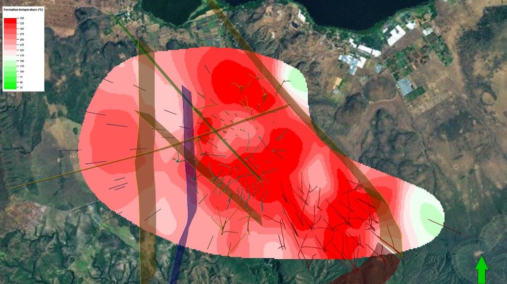
6 Figure 6: Horizontal view of the temperature distribution at 400 m a.s.l. (~1600 m depth) in the revised temperature model of the Olkaria geothermal system. Also shown are the main faults/fractures of the system. Figure 7: Horizontal view of the temperature distribution at 0 m a.s.l. (~2000 m depth) in the revised temperature model of the Olkaria geothermal system. Also shown are the main faults/fractures of the system. Figure 8: Horizontal view of the temperature distribution at -400 m a.s.l. (~2400 m depth) in the revised temperature model of the Olkaria geothermal system. Also shown are the main faults/fractures of the system. 6

7 Figure 9: A view of the temperature and pressure distribution in a NW-SE cross section through the Olkaria geothermal system. A good correlation between the deep-seated heat-source bodies proposed and the temperature conditions above 3 km depth can be seen in the above figures. It should, however, be noted that the micro-seismic study was conducted some 20 years ago. Thus a a repetition of that study, with more up-to-date analysis, would be highly beneficial. The revised temperature model also indicates that some sort of boundaries have been delinated in the Northeast and Domes fields with the wells drilled. These boundaries appear to be linked with with the Gorge Farm fault and the ring structure in the Domes (see Fig. 2), respectively. This was not seen before the conceptual model revision. The cross-sections presented in Fig. 9 indicate a general pressure- and temperature decline towards the NW. This can be interpreted as indicating a general flow from the center of the system towards NW, with an outflow in that region. The outflow may be delineated, or controlled, by the two NW-striking faults in the north part of the area (see Fig. 2). 2.3 The Model Revision The revision of the conceptual model for the Olkaria geothermal system presented here has emphasised (a) interpretation of data not available during development of previous conceptual models, (b) development of a new temperature and pressure model for the system, (c) analysis of the permeability structure and structural control of the geothermal system as well as (d) presentation of principal aspects of the conceptual model by a three-dimensional visualization software. The main results of the model revision are still valid and the reader is referred to details presented by Axelsson et al. (2013). The main aspects of this most recent ( ) revision of the conceptual model are the following: (1) During the conceptual model development the Olkaria geothermal resources were split in two; a heavily explored part where extensive drilling, testing and/or utilization had taken place and a less explored part where limited exploration had taken place, apart from some surface exploration. Since then the heavily explored area has expanded and the less explored area shrunk correspondingly through intense production well drilling. A peripheral zone defined on the edge of the heavily explored part in 2012 (Axelsson et al., 2013) has now been drilled and become part of the heavily explored part. 7
8 (2) The heat source of the geothermal system is assumed to be a deep-seated magma chamber or chambers, as in the 2011 version of the conceptual model. Three main intrusions are believed to extend up from the magma chamber(s) to shallower depths of 6 8 km. These heat source bodies (possibly partially molten) are proposed to lie beneath Olkaria Hill (Olkaria West), in the northeast beneath the Gorge Farm (Olkaria East and Northeast) volcanic centre, and in the Domes area. (3) Several major up-flow zones related to these heat sources can be identified from the temperature model, while their number (at least four) cannot be ascertained exactly. The existence of the most prominent up -flow zones is supported by chemical data. (4) The extent of the Olkaria geothermal resources is now better defined than before, clear boundaries have now been delineated, e.g. along the Gorge Farm fault in the Northeast area and along the ring structure on the southeast edge of the Domes area. These boundaries need to be explored further through additional drilling, as their nature may vary with depth (barriers at shallower levels, perhaps not so at greater depth). The extent of the resources has still not been delineated in other parts of the Olkaria area, such as in the north central part, the northwest part and the south-southwest part. This also applies to the far northeast corner of s concession area as well as the Hell s Gate area, where no drilling has been undertaken yet. (5) The recharge to the Olkaria system appears to be controlled by the main structural trends of the system, with the basic flow, especially at depth, being part of the deep Rift Valley ground-water current. At the flanks and in shallower parts it is to a differing extent mixed with water from the Rift Valley escarpments, most evidently in the Western field. Colder in-flow appears to be commonly occurring along major structural trends, e.g. the ring structure in the Domes, the Gorge Farm fault in the Northeast field and the central Ololbutot fault (see Fig. 2). (6) Understanding of the permeability structure of the Olkaria system has improved considerably in recent years, mainly through the intense drilling that has taken place. The permeability appears to be mainly controlled by predominantly NW-SE and NE- SW faults as well as the ring structure. It also appears to be quite significantly controlled by intersections of these structures. The main resource distribution, furthermore, follows a NW-SE trend, and the temperature and pressure model indicates general flow in that direction in the upper part of the system, including an outflow to the NW. (7) Recent deep drilling, e.g. in the centre of the geothermal system indicates that the Olkaria geothermal resources may extend to greater depth than explored through drilling so far. The base of the permeable part of the geothermal system has thus not been delineated yet. Deep roots research in other parts of the world (see e.g. may hint at the way forward for geothermal utilization in Olkaria. 2.4 Capacity Assessments Axelsson et al. (2013) review previous assessments of the production capacity of the Olkaria geothermal system. These mainly include several numerical modelling studies as well as volumetric and lumped parameter modelling studies. The first numerical model was e.g. developed in the 1980 s (Bödvarsson et al., 1990). Yet the optimization study involved the most comprehensive assessment of the Olkaria geothermal resources conducted to date. During the study the electrical generation capacity of the heavily explored part of s concession area in Olkaria, at that time, was estimated to be about 630 MW e based on a volumetric resource assessment, lumped parameter pressure response modelling and detailed numerical modelling (Axelsson et al., 2013). This included 150 MW e already installed and 280 MW e under construction, at the time. The results of the three different assessment methods were quite comparable, which added confidence to the results. The electrical generation capacity of the less explored part was estimated to be about 300 MW e based on a Monte Carlo volumetric assessment, an estimate that had to be confirmed through comprehensive exploration and drilling. Today (end of 2016) the capacity installed in s concession area corresponds to 530 MW e. It should be noted that in addition 140 MW e are installed in Olkaria West (Olkaria III) by OrPower-4. The numerical model set up in has been revised and updated during the model maintenance project. At the writing of this paper its revision is being finalized, and future predictions being calculated for different utilization scenarios. Preliminary results indicate a capacity of at least 800 MW e, but with quite a large pressure draw-down in some sectors. Yet the results for some parts of the system are uncertain because of limited testing and production experience; these sectors may also require more reinjection than modelled to manage pressure draw-down. Recent Monte Carlo volumetric assessments, of approximately half of what is now the less explored area, yield a P90 estimate of approximately 140 MW e, while the southwest and northeast corners of the concession area have not been assessed specifically during the project. 3. CONCLUSIONS This paper has described the principal aspects of the most up -to-date version of the conceptual model of the Olkaria geothermal system in Kenya. The model has been evolving concurrently with the development of the system for electrical energy generation, with the earliest version dating back to the 1970 s. The present version is the product of a comprehensive optimization study carried out during and a follow-up model maintenance project that started in 2014, and is now coming to an end. The present version is quite comprehensive and detailed for a large part of the geothermal system, mainly because of the extensive data collected through the roughly 165 deep production and exploration wells drilled in s licence area in the Olkaria field. The basis of the conceptual model is a comprehensive database incorporating almost all available Olkaria exploration-, well- and monitoring data, linked to a 3-D visualization software. Accompanying the conceptual model development has been the construction and revision of the largest and most comprehensive and detailed numerical model of the geothermal system set up to date. The conceptual model of the Olkaria geothermal system can be considered a living entity, which requires constant updating in order for it to be effective as a key tool in well-targeting and long-term management. It should, therefore, be updated regularly both on basis of new exploration data, data from new wells as they are drilled and tested, and very importantly on basis of constantly collect ed 8
9 monitoring data. As the geothermal system is very large and complex, and parts of it have not been thoroughly explored yet, variable research remains to be conducted. This will not be listed here, but we would like to point out the possibility that productive resources may still remain to be discovered at depth below the present maximum drilling depth of 3000 m, as the base of the permeable part of the geothermal system has not been delineated yet. Deep roots research, such as ongoing in Iceland, Italy and Japan may to some extent be the way forward for geothermal utilization in Olkaria. The Olkaria system is an unusually large and powerful geothermal system. During the last decade, its development and consequent expansion of power-plant capacity has been very rapid. This makes the need for comprehensive and efficient management extremely important, including large-scale reinjection, which by now has increased to almost 50%. Essential components of such management also include comprehensive and effective monitoring of the geothermal system s response to the large-scale utilization (e.g. accurate monitoring of its pressure decline) and the maintaining and application of the conceptual and numerical models. The present utilization and future development will be extremely important for Kenya as a country, and are expected to be accompanied by rapid economic, environmental and social benefits, in line with Kenya Vision 2030 ( The work presented here focusses on s licence area in Olkaria, while OrPower-4 also runs a sizable operation in their concession. Interference between the two concessions was not considered as being significant in the past, when both operations were much smaller in terms of capacity. This has now changed and we recommend that some sort of common management be set up for the whole Olkaria area, including the union of conceptual models and the construction of a common numerical model for both of s and OrPower-4 s concessions, in the near future. This also applies to other concessions, such as to the south and southeast of Olkaria, as their development is about to start to some extent. ACKNOWLEDGEMENTS The Kenya Electric Generating Company is acknowledged for allowing publication of the data presented in this paper. The authors would also like to express their appreciation to the numerous Kenyan scientists that have been involved in the exploration and development of the Olkaria geothermal system over the last 3 4 decades. REFERENCES Axelsson, G.: Conceptual models of geothermal systems Introduction, Proceedings of the Short Course on Conceptual Modelling of Geothermal Systems, UNU-GTP and LaGeo, Santa Tecla, El Salvador, (2013), 12 pp. Axelsson, G., Arnaldsson, A., Ármannsson, H. Árnason, K., Einarsson, G., Franzson, H., Fridriksson, Th., Gudmundsson, G., Gylfadóttir, S.S., Halldórsdóttir, S., Hersir, G.P., Mortensen, A.K., Thordarson, S., Jóhannesson, S., Bore, C., Karingithi, C., Koech, V., Mbithi, U., Muchemi, G., Mwarania, F., Opondo, K., and Ouma, P.: Update conceptual model and capacity estimates for the Greater Olkaria Geothermal System, Kenya, Proceedings of the 38 th Workshop on Geothermal Reservoir Engineering, Stanford University, California, February, (2013), 16 pp. Bödvarsson, G.S., Pruess, K., Haukwa, C., and Ojiambo, S B.: Evaluation of reservoir model predictions for the Olkaria East geothermal field, Kenya, Geothermics, 19, (1990), Grant, M. A., Donaldson, I.G., and Bixley, P.F.: Geothermal Reservoir Engineering, Academic Press, New York, (1982), 369 pp. Ofwona, C.O.: Olkaria I reservoir response to 28 years of production, Proceedings World Geothermal Congress 2010, Bali, Indonesia, April, (2010), 4 pp. Ofwona, C.O.: A reservoir study of Olkaria East geothermal system, Kenya, MSc thesis, University of Iceland and United Nations University Geothermal Training Programme, UNU-GTP report , Reykjavík, (2002), 74 pp. Ouma, P.: Geothermal exploration and development of the Olkaria geothermal field, Proceedings of Short Course V on Exploration for Geothermal Resources, UNU-GTP, GDC and, Lake Bogoria and Lake Naivasha, Kenya, October November, (2010), 16 pp. Simiyu, S.M.: Geothermal reservoir characterization: Application of microseismicity and seismic wave properties at Olkaria, Kenya rift, Journal of Geophysical Research, 105 (B6), (2000), 13,779-13,795. SWECO and Virkir: Feasibility report for the Olkaria geothermal project, Report prepared for The United Nations and Government of Kenya, (1976). 9
CONCEPTUAL MODEL AND RESOURCE ASSESSMENT FOR THE OLKARIA GEOTHERMAL SYSTEM, KENYA
 Presented at Short Course V on Conceptual Modelling of Geothermal Systems, organized by UNU-GTP and LaGeo, in Santa Tecla, El Salvador, February 24 - March 2, 2013. GEOTHERMAL TRAINING PROGRAMME LaGeo
HIGH TEMPERATURE HYDROTHERMAL ALTERATION IN ACTIVE GEOTHERMAL SYSTEMS A CASE STUDY OF OLKARIA DOMES
 Proceedings, 6 th African Rift Geothermal Conference Addis Ababa, Ethiopia, 2 nd 4 th November 2016 HIGH TEMPERATURE HYDROTHERMAL ALTERATION IN ACTIVE GEOTHERMAL SYSTEMS A CASE STUDY OF OLKARIA DOMES James
Structural Controls on the Chemistry and Output of the Wells in the Olkaria Geothermal Field, Kenya
 Proceedings 5 th African Rift geothermal Conference Arusha, Tanzania, 29-31 October 2014 Structural Controls on the Chemistry and Output of the Wells in the Olkaria Geothermal Field, Kenya (Wamalwa, R.N.)
Determination of Calcite Scaling Potential in OW-903 and OW-914 of the Olkaria Domes field, Kenya
 PROCEEDINGS, Fortieth Workshop on Geothermal Reservoir Engineering Stanford University, Stanford, California, January 26-28, 2015 SGP-TR-204 Determination of Calcite Scaling Potential in OW-903 and OW-914
Geophysical survey of a high-temperature field, Olkaria
 Presented at SDG Short Course I on Exploration and Development of Geothermal Resources, organized by UNU-GTP, GDC and KenGen, at Lake Bogoria and Lake Naivasha, Kenya, Nov. 10-31, 2016. Kenya Electricity
NATURAL-STATE MODEL UPDATE OF OLKARIA DOMES GEOTHERMAL FIELD
 Orkustofnun, Grensasvegur 9, Reports 2014 IS-108 Reykjavik, Iceland Number 7 NATURAL-STATE MODEL UPDATE OF OLKARIA DOMES GEOTHERMAL FIELD Maureen Nechesa Ambunya Kenya Electricity Generating Company KenGen
Update of the Conceptual Model of the Olkaria Geothermal System
 GRC Transactions, Vol. 40, 2016 Update of the Conceptual Model of the Olkaria Geothermal System Daniel Kenya Electricity Generating Company Limited, Naivasha, Kenya dsaitet@kengen.co.ke Keywords Olkaria,
An updated numerical model of the Greater Olkaria geothermal system, Kenya
 PROCEEDINGS, 43rd Workshop on Geothermal Reservoir Engineering Stanford University, Stanford, California, February 12-14, 2018 SGP-TR-213 An updated numerical model of the Greater Olkaria geothermal system,
INTERGRATED GEOPHYSICAL METHODS USED TO SITE HIGH PRODUCER GEOTHERMAL WELLS
 Presented at Short Course VII on Exploration for Geothermal Resources, organized by UNU-GTP, GDC and KenGen, at Lake Bogoria and Lake Naivasha, Kenya, Oct. 27 Nov. 18, 2012. GEOTHERMAL TRAINING PROGRAMME
Integrated Geophysical Model for Suswa Geothermal Prospect using Resistivity, Seismics and Gravity Survey Data in Kenya
 Proceedings World Geothermal Congress 2015 Melbourne, Australia, 19-25 April 2015 Integrated Geophysical Model for Suswa Geothermal Prospect using Resistivity, Seismics and Gravity Survey Data in Kenya
Structural Controls on the Geochemistry and Output of the Wells in the Olkaria Geothermal Field of the Kenyan Rift Valley
 International Journal of Geosciences, 216, 7, 1299-139 http://www.scirp.org/journal/ijg ISSN Online: 2156-8367 ISSN Print: 2156-8359 Structural Controls on the Geochemistry and Output of the Wells in the
APPLICATION OF GEOPHYSICS TO GEOTHERMAL ENERGY EXPLORATION AND MONITORING OF ITS EXPLOITATION
 Presented at Short Course III on Exploration for Geothermal Resources, organized by UNU-GTP and KenGen, at Lake Naivasha, Kenya, October 24 - November 17, 2008. GEOTHERMAL TRAINING PROGRAMME Kenya Electricity
Synthesis of Well Test Data and Modelling of Olkaria South East Production Field
 Proceedings World Geothermal Congress 2015 Melbourne, Australia, 19-25 April 2015 Synthesis of Well Test Data and Modelling of Olkaria South East Production Field Daniel Saitet Mailing address, P.O Box
NATURE AND ASSESSMENT OF GEOTHERMAL RESOURCES
 Presented at SDG Short Course I on Sustainability and Environmental Management of Geothermal Resource Utilization and the Role of Geothermal in Combating Climate Change, organized by UNU-GTP and LaGeo,
Applicability of GEOFRAC to model a geothermal reservoir: a case study
 PROCEEDINGS, Thirty-Ninth Workshop on Geothermal Reservoir Engineering Stanford University, Stanford, California, February 24-26, 2014 SGP-TR-202 Applicability of GEOFRAC to model a geothermal reservoir:
Geothermal Potential of the Kenya Rift: energy estimates based on new data. Peter Omenda and Silas Simiyu KenGen
 Geothermal Potential of the Kenya Rift: energy estimates based on new data Peter Omenda and Silas Simiyu KenGen 1 Introduction Kenya relies on three major sources of energy in the electricity sub sector:
DYNAMIC MODELLING OF GEOTHERMAL SYSTEMS
 Presented at Short Course V on Conceptual Modelling of Geothermal Systems, organized by UNU-GTP and LaGeo, in Santa Tecla, El Salvador, February 24 - March 2, 2013. GEOTHERMAL TRAINING PROGRAMME LaGeo
GEOTHERMAL ENERGY POTENTIAL FOR LONGONOT PROSPECT, KENYA. By Mariita N. O. Kenya Electricity Generating Company
 GEOTHERMAL ENERGY POTENTIAL FOR LONGONOT PROSPECT, KENYA By Mariita N. O. Kenya Electricity Generating Company PRESENTATION OUTLINE INTRODUCTION REGIONAL SETTING GEOLOGY GEOTHERMAL MANIFESTATIONS HYDROGEOLOGY
INITIAL CONDITIONS OF WELLS OW 905A, OW 907A, OW 913A AND OW 916A, AND A SIMPLE NATURAL STATE MODEL OF OLKARIA DOMES GEOTHERMAL FIELD, KENYA
 GEOTHERMAL TRAINING PROGRAMME Reports 2011 Orkustofnun, Grensasvegur 9, Number 17 IS-108 Reykjavik, Iceland INITIAL CONDITIONS OF WELLS OW 905A, OW 907A, OW 913A AND OW 916A, AND A SIMPLE NATURAL STATE
THE USE OF GIS IN GEOTHERMAL RESOURCE MANAGEMENT: A CASE STUDY OF OLKARIA GEOTHERMAL PROJECT
 Presented at SDG Short Course II on Exploration and Development of Geothermal Resources, organized by UNU-GTP, GDC and KenGen, at Lake Bogoria and Lake Naivasha, Kenya, Nov. 9-29, 2017. Kenya Electricity
Renewability Assessment of the Reykjanes Geothermal System, SW-Iceland. Gudni Axelsson et al. (see next slide) Iceland GeoSurvey (ÍSOR)
 Iceland GeoSurvey (ÍSOR)") Renewability Assessment of the Reykjanes Geothermal System, SW-Iceland (see next slide) Iceland GeoSurvey (ÍSOR) Contributors Iceland GeoSurvey (ÍSOR): Gudni Axelsson, Egill Á. Gudnason, Ragna Karlsdóttir
Renewability Assessment of the Reykjanes Geothermal System, SW-Iceland (see next slide) Iceland GeoSurvey (ÍSOR) Contributors Iceland GeoSurvey (ÍSOR): Gudni Axelsson, Egill Á. Gudnason, Ragna Karlsdóttir
INITIAL CONDITIONS OF WELLS OW-906A, OW-908, OW-910A AND OW-914 AND A SIMPLE NATURAL STATE MODEL OF OLKARIA DOMES GEOTHERMAL FIELD, KENYA
 GEOTHERMAL TRAINING PROGRAMME Report 2011 Orkustofnun, Grensasvegur 9, Number 22 IS-108 Reykjavik, Iceland INITIAL CONDITIONS OF WELLS OW-906A, OW-908, OW-910A AND OW-914 AND A SIMPLE NATURAL STATE MODEL
LECTURES ON GEOTHERMAL IN KENYA AND AFRICA
 GEOTHERMAL TRAINING PROGRAMME Reports 2005 Orkustofnun, Grensásvegur 9, Number 4 IS-108 Reykjavík, Iceland LECTURES ON GEOTHERMAL IN KENYA AND AFRICA Martin N. Mwangi (lecturer and co-ordinator) Kenya
NUMERICAL MODELING STUDY OF SIBAYAK GEOTHERMAL RESERVOIR, NORTH SUMATRA, INDONESIA
 PROCEEDINGS, Twenty-Sixth Workshop on Geothermal Reservoir Engineering Stanford University, Stanford, California, January 29-31, 21 SGP-TR-168 NUMERICAL MODELING STUDY OF SIBAYAK GEOTHERMAL RESERVOIR,
GEOTHERMAL WELL TARGET APPROACHES IN THE EXPLORATION STAGE
 Presented at Short Course on Geothermal Drilling, Resource Development and Power Plants, organized by UNU-GTP and LaGeo, in Santa Tecla, El Salvador, January 16-22, 2011. GEOTHERMAL TRAINING PROGRAMME
Reservoir Evaluation and Modelling of the Eburru Geothermal System, Kenya
 Reservoir Evaluation and Modelling of the Eburru Geothermal System, Kenya Felix Mutugi Mwarania Faculty of Industrial Engineering, Mechanical Engineering and Computer Science University of Iceland 2014
RESPONSE OF WAIRAKEI GEOTHERMAL RESERVOIR TO 40 YEARS OF PRODUCTION
 RESPONSE OF WAIRAKEI GEOTHERMAL RESERVOIR TO 4 YEARS OF PRODUCTION Allan Clotworthy Contact Energy Ltd, Private Bag 21, Taupo, New Zealand Key Words: geothermal, production, reinjection, reservoir, Wairakei
Numerical Simulation of Devolution and Evolution of Steam-Water Two-Phase Zone in a Fractured Geothermal Reservoir at Ogiri, Japan
 GRC Transactions, Vol. 37, 2013 Numerical Simulation of Devolution and Evolution of Steam-Water Two-Phase Zone in a Fractured Geothermal Reservoir at Ogiri, Japan Yohei Tateishi 1, Ryuichi Itoi 1, Toshiaki
Characterization of Subsurface Permeability of the Olkaria East Geothermal Field
 PROCEEDINGS, 44th Workshop on Geothermal Reservoir Engineering Stanford University, Stanford, California, February 11-13, 2019 SGP-TR-214 Characterization of Subsurface Permeability of the Olkaria East
Renewability Assessment of the Reykjanes Geothermal System, SW-Iceland
 Proceedings World Geothermal Congress 2015 Melbourne, Australia, 19-25 April 2015 Renewability Assessment of the Reykjanes Geothermal System, SW-Iceland Gudni Axelsson 1),2), Andri Arnaldsson 3), Jean-Claude
TORFAJÖKULL, ICELAND A RHYOLITE VOLCANO AND ITS GEOTHERMAL RESOURCE
 Presented at Short Course VI on Exploration for Geothermal Resources, organized by UNU-GTP, GDC and KenGen, at Lake Bogoria and Lake Naivasha, Kenya, Oct. 27 Nov. 18, 2011. GEOTHERMAL TRAINING PROGRAMME
GEOTHERMAL WELL SITING USING GIS: A CASE STUDY OF MENENGAI GEOTHERMAL PROSPECT
 GEOTHERMAL WELL SITING USING GIS: A CASE STUDY OF MENENGAI GEOTHERMAL PROSPECT Levi Shako Geothermal Development Company P. O Box 17700-20100, Nakuru, Kenya. lshako@gdc.co.ke ABSTRACT Geothermal well site
ANALYSIS OF DOWNHOLE DATA AND PRELIMINARY PRODUCTION CAPACITY ESTIMATE FOR THE OLKARIA DOMES GEOTHERMAL FIELD, KENYA
 GEOTHERMAL TRAINING PROGRAMME Reports 1999 Orkustofnun, Grensásvegur 9, Number 11 IS-108 Reykjavík, Iceland ANALYSIS OF DOWNHOLE DATA AND PRELIMINARY PRODUCTION CAPACITY ESTIMATE FOR THE OLKARIA DOMES
Heat Loss Assessment of Selected Kenyan Geothermal Prospects
 GRC Transactions, Vol. 36, 2012 Heat Loss Assessment of Selected Kenyan Geothermal Prospects Hilary M. Mwawasi Geothermal Development Company, Nairobi, Kenya hmwawasi@gdc.co.ke Keywords Geothermal prospects,
GEOTHERMAL DEVELOPMENT IN UGANDA
 GEOTHERMAL DEVELOPMENT IN UGANDA Uganda is a geothermal country due to its geological location. It is endowed with a rift valley which is an extensional zone with a thinned earth crust. The thinned crust
NOTICE CONCERNING COPYRIGHT RESTRICTIONS
 NOTICE CONCERNING COPYRIGHT RESTRICTIONS This document may contain copyrighted materials. These materials have been made available for use in research, teaching, and private study, but may not be used
COUNTRY UPDATE REPORT FOR KENYA 2016
 Proceedings, 6 th African Rift Geothermal Conference Addis Ababa, Ethiopia, 2 nd 4 th November 2016 COUNTRY UPDATE REPORT FOR KENYA 2016 1 Peter Omenda and 2 Peketsa Mangi 1 Geothermal Consultant, P. O.
WELL TEST ANALYSIS AND TEMPERATURE AND PRESSURE MONITORING OF KRAFLA AND NESJAVELLIR HIGH-TEMPERATURE GEOTHERMAL FIELDS, ICELAND
 Orkustofnun, Grensasvegur 9, Reports 2014 IS-108 Reykjavik, Iceland Number 25 WELL TEST ANALYSIS AND TEMPERATURE AND PRESSURE MONITORING OF KRAFLA AND NESJAVELLIR HIGH-TEMPERATURE GEOTHERMAL FIELDS, ICELAND
SUB-SURFACE GEOLOGY AND HYDROTHERMAL ALTERATION OF WELLS LA-9D AND LA-10D OF ALUTO LANGANO GEOTHERMAL FIELD, ETHIOPIA
 Proceedings, 6 th African Rift Geothermal Conference Addis Ababa, Ethiopia, 2 nd -4 th November 2016 SUB-SURFACE GEOLOGY AND HYDROTHERMAL ALTERATION OF WELLS LA-9D AND LA-10D OF ALUTO LANGANO GEOTHERMAL
A RESERVOIR STUDY OF OLKARIA EAST GEOTHERMAL SYSTEM, KENYA
 GEOTHERMAL TRAINING PROGRAMME Reports 2002 Orkustofnun, Grensásvegur 9, Number IS-08 Reykjavík, Iceland A RESERVOIR STUDY OF OLKARIA EAST GEOTHERMAL SYSTEM, KENYA M.Sc. Thesis Department of Civil and Environmental
Geology and Hydrothermal Alteration in the Reservoir of the Hellisheiði High Temperature System, SW-Iceland
 Proceedings World Geothermal Congress 2010 Bali, Indonesia, 25-9 April 2010 Geology and Hydrothermal Alteration in the Reservoir of the Hellisheiði High Temperature System, SW-Iceland Helga Margrét Helgadóttir,
Geology and Hydrothermal Alteration of the Hverahlid HT-System, SW-Iceland
 Proceedings World Geothermal Congress 2010 Bali, Indonesia, 25-29 April 2010 Geology and Hydrothermal Alteration of the Hverahlid HT-System, SW-Iceland Steinþór Níelsson and Hjalti Franzson ISOR Iceland
ESTIMATING THE GEOTHERMAL POWER POTENTIAL OF THE NW-SABALAN GEOTHERMAL FIELD, IRAN, BY THE VOLUMETRIC METHOD
 ESTIMATING THE GEOTHERMAL POWER POTENTIAL OF THE NW-SABALAN GEOTHERMAL FIELD, IRAN, BY THE VOLUMETRIC METHOD Farhad Abdollahzadeh Bina, Parnaz Johari Sefid, Soheil Porkhial SUNA Renewable Energy Organization
Preliminary Microgravity Measurement Of Paka Geothermal Prospect
 Preliminary Microgravity Measurement Of Paka Geothermal Prospect Presented by: Levi Shako and Calistus Ndongoli Date: 4/November/2016 Venue: Addis Ababa, Ethiopia Introduction Microgravity is a geophysical
Three Dimensional Inversions of MT Resistivity Data to Image Geothermal Systems: Case Study, Korosi Geothermal Prospect
 PROCEEDINGS, 42nd Workshop on Geothermal Reservoir Engineering Stanford University, Stanford, California, February 13-15, 2017 SGP-TR-212 Three Dimensional Inversions of MT Resistivity Data to Image Geothermal
GEOTHERMAL ENERGY EXPLORATION IN UGANDA, COUNTRY UPDATE 2006
 GEOTHERMAL ENERGY EXPLORATION IN UGANDA, COUNTRY UPDATE 2006 Godfrey Bahati Department of Geological Survey and Mines, P.O Box 9, Entebbe, Uganda First East African Rift Geothermal Conference-ARGeo ARGeo-C1
MODELLING OF CONDITIONS CLOSE TO GEOTHERMAL HEAT SOURCES
 MODELLING OF CONDITIONS CLOSE TO GEOTHERMAL HEAT SOURCES Sæunn Halldórsdóttir (ÍSOR), Inga Berre (UiB), Eirik Keilegavlen (UiB) and Guðni Axelsson (ÍSOR) Photo: Auður Agla, ÍSOR Heat transfer in geothermal
Vincent Kipkirui Koech
 Blési hot spring at Geysir geothermal field Vincent Kipkirui Koech NUMERICAL GEOTHERMAL RESERVOIR MODELLING AND INFIELD REINJECTION DESIGN, CONSTRAINED BY TRACER TEST DATA: CASE STUDY FOR THE OLKARIA GEOTHERMAL
INFRARED AND SATELLITE IMAGES, AERIAL PHOTOGRAPHY
 Presented at Short Course VI on Exploration for Geothermal Resources, organized by UNU-GTP, GDC and KenGen, at Lake Bogoria and Lake Naivasha, Kenya, Oct. 27 Nov. 18, 2011. GEOTHERMAL TRAINING PROGRAMME
Geothermometer, Geoindicator and Isotope Monitoring in Lahendong Wells during
 Proceedings World Geothermal Congress 2015 Melbourne, Australia, 19-25 April 2015 Geothermometer, Geoindicator and Isotope Monitoring in Lahendong Wells during 2010-2012 Azka G., Suryanto S. and Yani A.
James Francis Natukunda
 James Francis Natukunda Department of Geological Surveys and Mines Ministry of Energy and Mineral Development, Uganda Regional stakeholders workshop for EARS countries and partners Nairobo, Kenya 15-17
A New Combinational Terminology for Geothermal Systems
 International Journal of Geosciences, 2013, 4, 43-48 http://dx.doi.org/10.4236/ijg.2013.41005 Published Online January 2013 (http://www.scirp.org/journal/ijg) A New Combinational Terminology for Geothermal
United Nations University Geothermal Training Programme Iceland
 United Nations University Geothermal Training Programme Iceland Ingvar B. Fridleifsson, director United Nations University Geothermal Training Programme Reykjavik, Iceland www.unugtp.is United Nations
Three Dimensional Modeling of Geological Parameters in Volcanic Geothermal Systems. Part I Methods and Data.
 Proceedings World Geothermal Congress 2015 Melbourne, Australia, 19-25 April 2015 Three Dimensional Modeling of Geological Parameters in Volcanic Geothermal Systems. Part I Methods and Data. Gunnlaugur
APPENDICES TO THE REPORT: JOINT 1-D INVERSION OF TEM AND MT DATA FROM OLKARIA DOMES GEOTHERMAL AREA, KENYA
 GEOTHERMAL TRAINING PROGRAMME Reports 2009 Orkustofnun, Grensásvegur 9, Number 16 IS-108 Reykjavík, Iceland APPENDICES TO THE REPORT: JOINT 1-D INVERSION OF TEM AND MT DATA FROM OLKARIA DOMES GEOTHERMAL
ISOR Iceland GeoSurvey Geothermal exploration and development
 ISOR Iceland GeoSurvey Geothermal exploration and development ISOR - Iceland GeoSurvey Owned by the Icelandic government. Provides specialist services to the Icelandic power industry, the Icelandic government
Annað veldi ehf. Geothermal Provinces of Kenya
 Annað veldi ehf Geothermal Provinces of Kenya David Köndgen and Skuli Johannsson September 29, 2009 OUTLINE Overview Geology of Kenya Excursus: The Wilson Cycle How do rifts form? The world of Platetectonics
STATUS OF GEOTHERMAL EXPLORATION IN KENYA AND FUTURE PLANS FOR ITS DEVELOPMENT
 GEOTHERMAL TRAINING PROGRAMME 30 th Anniversary Workshop Orkustofnun, Grensásvegur 9, August 26-27, 2008 IS-108 Reykjavík, Iceland STATUS OF GEOTHERMAL EXPLORATION IN KENYA AND FUTURE PLANS FOR ITS DEVELOPMENT
THE FLUID CHARACTERISTICS OF THREE EXPLORATION WELLS DRILLED AT OLKARIA-DOMES FIELD, KENYA
 PROCEEDINGS, Thirty-Third Workshop on Geothermal Reservoir Engineering Stanford University, Stanford, California, January 28-3, 28 SGP-TR-185 THE FLUID CHARACTERISTICS OF THREE EXPLORATION WELLS DRILLED
Country Update Report for Kenya
 Proceedings World Geothermal Congress 2015 Melbourne, Australia, 19-25 April 2015 Country Update Report for Kenya 2010-2014 Peter Omenda and Silas Simiyu Geothermal Development Company, P. O. Box 100746,
Thermal Modeling of the Mountain Home Geothermal Area
 PROCEEDINGS, 41st Workshop on Geothermal Reservoir Engineering Stanford University, Stanford, California, February 22-24, 2016 SGP-TR-209 Thermal Modeling of the Mountain Home Geothermal Area Sabodh K.
WAMUNYU EDWARD MUREITHI I13/2358/2007
 WAMUNYU EDWARD MUREITHI I13/2358/2007 Olkaria geothermal area is situated south of Lake Naivasha on the floor of the southern segment of the Kenya rift. The geology of the Olkaria Geothermal area is subdivided
Technical Requirements of Geothermal Exploration in the RSM DADI THORBJORNSON, RSM CONSULTANT WORKSHOP SWISS HOTEL IZMIR 5 JULY 2018
 Technical Requirements of Geothermal Exploration in the RSM DADI THORBJORNSON, RSM CONSULTANT WORKSHOP SWISS HOTEL IZMIR 5 JULY 2018 JV Partners Engineering firm with hundred twenty years of experience
Japan Engineering Consultants, Inc., Energy and Industrial Technology Development Organization,Tokyo, Japan
 DEEP GEOTHERMAL STRUCTURE AND THE HYDROTHERMAL SYSTEM THE GEOTHERMAL FIELD, JAPAN M. H. K. MATSUDA', T. K. Japan Engineering Consultants, Inc., Japan Energy and Industrial Technology Development Organization,Tokyo,
Geophysical Exploration of High Temperature Geothermal Areas using Resistivity Methods. Case Study: TheistareykirArea, NE Iceland
 Proceedings World Geothermal Congress 2015 Melbourne, Australia, 19-25 April 2015 Geophysical Exploration of High Temperature Geothermal Areas using Resistivity Methods. Case Study: TheistareykirArea,
INTERPRETATION OF INTERFERENCE EFFECTS IN THREE PRODUCTION WELLS IN THE KAWERAU GEOTHERMAL FIELD, NEW ZEALAND. Lynell Stevens and Kevin J Koorey
 PROCEEDINGS, Twenty-First Workshop on Geothermal Reservoir Engineering Stanford University, Stanford, California, January 22-24, 1996 SGP-TR-151 INTERPRETATION OF INTERFERENCE EFFECTS IN THREE PRODUCTION
Reykjavík. Hengill central volcano. 1. Geological map of SW-Iceland and location of Hengill central volcano and the Reykjavík capital.
 PROCEEDINGS, Thirty-Seventh Workshop on Geothermal Reservoir Engineering Stanford University, Stanford, California, January 30 - February 1, 2012 SGP-TR-194 PRELIMINARY STUDY OF DOWN-HOLE RESISTIVITY FROM
Activity Submitted by Tim Schroeder, Bennington College,
 Structural Analysis of a Hot Dry Rock Geothermal Energy System Activity Submitted by Tim Schroeder, Bennington College, tschroeder@bennington.edu Description: This project applies basic geologic skills
Outcomes of the Workshop on the Geologic and Geothermal Development of the Western Branch of the Greater East African Rift System
 Outcomes of the Workshop on the Geologic and Geothermal Development of the Western Branch of the Greater East African Rift System East Africa Donor Coordination Meeting 14 June 2016 AUC Headquarter Addis
SEISMICITY AT THE MIRAVALLES GEOTHERMAL FIELD, COSTA RICA ( ): A TOOL TO CONFIRM THE REAL EXTENSION OF THE RESERVOIR*
: A TOOL TO CONFIRM THE REAL EXTENSION OF THE RESERVOIR*") Presented at Short Course on Surface Exploration for Geothermal Resources, organized by UNU-GTP and LaGeo, in Ahuachapan and Santa Tecla, El Salvador, 17-30 October, 2009. GEOTHERMAL TRAINING PROGRAMME
Presented at Short Course on Surface Exploration for Geothermal Resources, organized by UNU-GTP and LaGeo, in Ahuachapan and Santa Tecla, El Salvador, 17-30 October, 2009. GEOTHERMAL TRAINING PROGRAMME
GeothermEx, Inc. GEOTHERMAL RESERVOIR ASSESSMENT METHODOLOGY FOR THE SCIENTIFIC OBSERVATION HOLE PROGRAM, KILAUEA EAST RIFT ZONE, HAWAII TASK 1 REPORT
 (415) 527 9876 CABLE ADDRESS- GEOTHERMEX TELEX 709152 STEAM UD FAX (415) 527-8164 Geotherm Ex, Inc. RICHMOND. CALIFORNIA 94804-5829 GEOTHERMAL RESERVOIR ASSESSMENT METHODOLOGY FOR THE SCIENTIFIC OBSERVATION
Temperature Condition Modelling for well IDDP-1 in Krafla, N-Iceland
 Proceedings of SIMS 2012, the 53 rd Scandinavian Simulation and Modelling Society Conference Reykjavik, Iceland, 4 6 October 2012 Temperature Condition Modelling for well IDDP-1 in Krafla, N-Iceland Gudni
Numerical Simulation Study of the Mori Geothermal Field, Japan
 Proceedings World Geothermal Congress 2010 Bali, Indonesia, 25-29 April 2010 Numerical Simulation Study of the Mori Geothermal Field, Japan Kazuyoshi Osada 1, Mineyuki Hanano 2, Kei Sato 1, Tatsuya Kajiwara
GEOTHERMAL BOREHOLE INVESTIGATIONS DURING AND AFTER DRILLING
 Presented at Workshop for Decision Makers on Geothermal Projects in Central America, organized by UNU-GTP and LaGeo in San Salvador, El Salvador, 26 November to 2 December 2006. GEOTHERMAL BOREHOLE INVESTIGATIONS
TEMPERATURE DISTRIBUTION AND CONCEPTUAL RESERVOIR MODEL FOR GEOTHERMAL FIELDS IN AND AROUND THE CITY OF REYKJAVÍK, ICELAND
 PROCEEDINGS, Twenty-fifth Workshop on Geothermal Reservoir Engineering Stanford University, Stanford, California, January 24-26, 2000 SGP-TR-165 TEMPERATURE DISTRIBUTION AND CONCEPTUAL RESERVOIR MODEL
STATUS OF GEOTHERMAL ENERGY PROJECTS IN TANZANIA
 STATUS OF GEOTHERMAL ENERGY PROJECTS IN TANZANIA Regional Geothermal Stakeholders Workshop for East African Rift System Countries and Partners 15-17 March 2010 Nairobi - Kenya Gabriel Mbogoni (Geologist-GST)
CO2 storage potential of basaltic rocks in Iceland and the oceanic ridges
 CO storage potential of basaltic rocks in Iceland and the oceanic ridges Sandra Ó. Snæbjörnsdóttir, Frauke Wiese, Thráinn Fridriksson, Halldór Ármannsson, Sigurdur R. Gislason NORDICCS Conference Contribution
Worldwide Power Density Review
 PROCEEDINGS, Thirty-Ninth Workshop on Geothermal Reservoir Engineering Stanford University, Stanford, California, February 24-26, 2014 SGP-TR-202 Worldwide Power Density Review Maxwell Wilmarth 1, James
THREE DIMENSIONAL INVERSIONS OF MT RESISTIVITY DATA TO IMAGE GEOTHERMAL SYSTEMS: CASE STUDY, KOROSI GEOTHERMAL PROSPECT.
 Proceedings, 6 th African Rift Geothermal Conference Addis Ababa, Ethiopia, 2 nd 4 th November 2016 THREE DIMENSIONAL INVERSIONS OF MT RESISTIVITY DATA TO IMAGE GEOTHERMAL SYSTEMS: CASE STUDY, KOROSI GEOTHERMAL
OVERVIEW OF THE WAIRAKEI-TAUHARA SUBSIDENCE INVESTIGATION PROGRAM
 PROCEEDINGS, Thirty-Sixth Workshop on Geothermal Reservoir Engineering Stanford University, Stanford, California, January 31 - February 2, 2011 SGP-TR-191 OVERVIEW OF THE WAIRAKEI-TAUHARA SUBSIDENCE INVESTIGATION
Application of Transient Electromagnetics for the Investigation of a Geothermal Site in Tanzania
 Application of Transient Electromagnetics for the Investigation of a Geothermal Site in Tanzania Gerlinde Schaumann, Federal Institute for Geosciences and Natural Resources (BGR), Stilleweg 2, 30655 Hannover,
Geo-scientific Data Integration to Evaluate Geothermal Potential Using GIS (A Case for Korosi-Chepchuk Geothermal Prospects, Kenya)
") Geo-scientific Data Integration to Evaluate Geothermal Potential Using GIS (A Case for Korosi-Chepchuk Geothermal Prospects, Kenya) Levi Shako and Joseph Mutua Geothermal Development Company, P. O. Box
Geo-scientific Data Integration to Evaluate Geothermal Potential Using GIS (A Case for Korosi-Chepchuk Geothermal Prospects, Kenya) Levi Shako and Joseph Mutua Geothermal Development Company, P. O. Box
GEOTHERMAL EXPLORATION PHASE
 Presented at Short Course on Geothermal Project Management and Development, organized by UNU-GTP, KenGen and MEMD-DGSM, at the Imperial Botanical Beach Hotel, Entebbe, Uganda, November 20-22, 2008. GEOTHERMAL
This paper summarizes what we know about a fascinating, previously unknown hi T geothermal system in SE Idaho
 This paper summarizes what we know about a fascinating, previously unknown hi T geothermal system in SE Idaho that came to light during the compilation of geothermally relevant data for the DOE s National
Data Fusion for Hydrothermal Reservoir Characterization through use of Bayesian Statistical Inference and MCMC Maximum Likelihood Models
 PROCEEDINGS, 42nd Workshop on Geothermal Reservoir Engineering Stanford University, Stanford, California, February 13-15, 2017 SGP-TR-212 Data Fusion for Hydrothermal Reservoir Characterization through
PRESSURE PERTURBATIONS IN TWO PHASE GEOTHERMAL RESERVOIR ASSOCIATED WITH SEISMISITY
 PROCEEDINGS, Twenty-Eighth Workshop on Geothermal Reservoir Engineering Stanford University, Stanford, California, January 27-29, 2003 SGP-TR-173 PRESSURE PERTURBATIONS IN TWO PHASE GEOTHERMAL RESERVOIR
Outcomes of the Workshop on the Geologic and Geothermal Development of the Western Branch of the Greater East African Rift System
 Outcomes of the Workshop on the Geologic and Geothermal Development of the Western Branch of the Greater East African Rift System Energy Ministerial Meeting 13 June 2016 AUC Headquarter Addis Ababa, Ethiopia
Geothermal Systems: Geologic Origins of a Vast Energy Resource
 Geothermal Systems: Geologic Origins of a Vast Energy Resource Energy From the Earth Energy-Land-Water Connections Speaker Series James E. Faulds, PhD Nevada State Geologist and Professor Nevada Bureau
3D MAGNETOTELLURIC SURVEY AT THE YANAIZU-NISHIYAMA GEOTHERMAL FIELD, NORTHERN JAPAN
 3D MAGNETOTELLURIC SURVEY AT THE YANAIZU-NISHIYAMA GEOTHERMAL FIELD, NORTHERN JAPAN Toshihiro Uchida 1, Shinichi Takakura 1, Takumi Ueda 1, Masaho Adachi 2, Hitoshi Ozeki 2, Kunikazu Kamada 3, Tatsuya
Geothermal Exploration in Eritrea
 Geothermal Exploration in Eritrea Ermias Yohannes, Eritrea Ministry of Energy and Mines, Department of Mines ermias_yohannes@yahoo.com Short Course on Surface Exploration for Geothermal Resources UNU-GTP
NOTICE CONCERNING COPYRIGHT RESTRICTIONS
 NOTICE CONCERNING COPYRIGHT RESTRICTIONS This document may contain copyrighted materials. These materials have been made available for use in research, teaching, and private study, but may not be used
Exploration of Geothermal High Enthalpy Resources using Magnetotellurics an Example from Chile
 Exploration of Geothermal High Enthalpy Resources using Magnetotellurics an Example from Chile Ulrich Kalberkamp, Federal Institute for Geosciences and Natural Resources (BGR), Stilleweg 2, 30655 Hannover,
Evaluation of Subsurface Structures Using Hydrothermal Alteration Mineralogy A Case Study of Olkaria South East Field
 GRC Transactions, Vol. 39, 2015 Evaluation of Subsurface Structures Using Hydrothermal Alteration Mineralogy A Case Study of Olkaria South East Field Michael M. Mwania Kenya Electricity Generating Company
A VOLCANOSEISMIC APPROACH TO GEOTHERMAL EXPLORATION AND RESERVOIR MONITORING: OLKARIA, KENYA AND CASA DIABLO, USA
 A VOLCANOSEISMIC APPROACH TO GEOTHERMAL EXPLORATION AND RESERVOIR MONITORING: OLKARIA, KENYA AND CASA DIABLO, USA Silas M. Simiyu 1 and Peter E. Malin 2 1 The Kenya Electricity Generating Company, P.O
Overview of geophysical methods used in geophysical exploration
 Overview of geophysical methods used in geophysical exploration Lúdvík S. Georgsson United Nations University Geothermal Training Programme Orkustofnun Reykjavík ICELAND The role of the geophysicist Measuring
TOWARDS THE USE OF GIS IN GEOTHERMAL RESOURCE MANAGEMENT- A CASE STUDY OF OLKARIA GEOTHERMAL PROJECT ABSTRACT
 TOWARDS THE USE OF GIS IN GEOTHERMAL RESOURCE MANAGEMENT- A CASE STUDY OF OLKARIA GEOTHERMAL PROJECT Fred Wekesa and Beatrice Gichini Olkaria Geothermal Project Kenya Electricity Generating Company Ltd
GEOTHERMAL POTENTIAL OF ST. KITTS AND NEVIS ISLANDS
 GEOTHERMAL POTENTIAL OF ST. KITTS AND NEVIS ISLANDS By Gerald W. Huttrer Geothermal Management Company, Inc. For the Eastern Caribbean Geothermal Energy Project ( Geo- Caraibes ; G-C ) Presented Using
SECOND AFRICAN RIFT GEOTHERMAL CONFERENCE 24 th -28 th NOVEMBER, 2008 ENTEBBE, UGANDA. Ministry of Infrastructure P.O. Box:24, Kigali Rwanda
 SECOND AFRICAN RIFT GEOTHERMAL CONFERENCE 24 th -28 th NOVEMBER, 2008 ENTEBBE, UGANDA Ministry of Infrastructure P.O. Box:24, Kigali Rwanda Uwera RUTAGARAMA In charge of geothermal development Introduction
Tu D Understanding the Interplay of Fractures, Stresses & Facies in Unconventional Reservoirs - Case Study from Chad Granites
 Tu D201 04 Understanding the Interplay of Fractures, Stresses & Facies in Unconventional Reservoirs - Case Study from Chad Granites D. Lirong (Chinese National Petroleum Company Ltd. (Chad)), C. Shrivastava*
NICARAGUA COUNTRY UPDATE. Ariel Zúñiga and Mauricio Medina. Instituto Nicaragüense de Energía, Apartado Postal 3226
 NICARAGUA COUNTRY UPDATE Ariel Zúñiga and Mauricio Medina Instituto Nicaragüense de Energía, Apartado Postal 3226 Abstract Geothermal studies in Nicaragua started at the end of the 1960s, demonstrating