Landslide risk. Prof. Nicola Casagli Director of ICL European Centre, University of Florence (Italy)
|
|
|
- Chad Henderson
- 6 years ago
- Views:
Transcription
 Preparatory Workshop on Science and Technology for")
1 Consortium on Landslides Landslide risk Prof. Nicola Casagli Director of ICL European Centre, University of Florence (Italy) Preparatory Workshop on Science and Technology for the Global Platform for Disaster Risk Reduction Third Session Pavia, Italy, 5-6 April 2011


2 nsortium on Landslides L is an International non-governmental and fit scientific organization, which is supported SCO, WMO, FAO and UN/ISDR and other mental bodies
3 an international initiative of ICL ims to conduct international erative research and capacity ing on landslide risk mitigation, ly in developing countries. ction of cultural and natural ge is addressed for the benefit of ty and the environment.

4 The Tokyo Action Plan was ad at the Round Table Discussion organized at the United Nation University in Tokyo from 18th t January The Plan proposed the IPL, for implementation of the Hyogo Framework for Action, jointly m by ICL and global stakeholders field. ICL exchanged MoU with UNE


5 shop on Landslide Risk Reduction ganized at IDRC in Davos 2006 for
, d by the ICL and")

6 World Landslide Forum (18-21 November 2008, Tokyo, Japan), d by the ICL and other supporting organizations ticipants from 48 countries adopted the 2008 Tokyo Declaration

7 ICL-Europe raise funds, from the EC and other ding agencies, for supporting IPL promote IPL in order to bring ether the landslide community in rope aid the co-ordination of activities of uropean Centre of ICL tablished at the Earth ces Department of the rsity of Florence with llowing objectives: On 29th June 2006 in Heidelberg, a MoU b ICL and UNIFI was exchanged to establis European Centre of IC

8 ICL/IPL members

9 ICL/IPL members

10 ndslides International Journa urnal addresses a wide array ciplines, is of broad interest, ly readable and of high quality ues per year d from January 2004 d by Springer olor es of contributions: Landslide s, Scientific papers and

11 PL Project Landslide tigation in Machu Picchu, involves working groups from Peru, Japan, Italy, h, Slovakia, Canada and tigation by all working s is coordinated as an roject, and the report of tigation are presented to ian Government through CO as a single
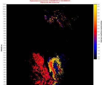
12 roject coordinated by kuoka roject contains ng groups from all embers Site: Vajont Nation: Italy Date: 10 Oct. 196 Type: rock slide Volume: m Velocity: 12 m/s Travel angle: 18.8 Victims: 1917 Trigger: reservo ives: te a global landslide se of major events ister them in a rd data-format onresent them on a
13 Site: Vajont Nation: Italy Date: 10 Oct Type: rock slide Volume: m3 Velocity: 12 m/s Travel angle: 18.8 Victims: 1917 Trigger: reservoir
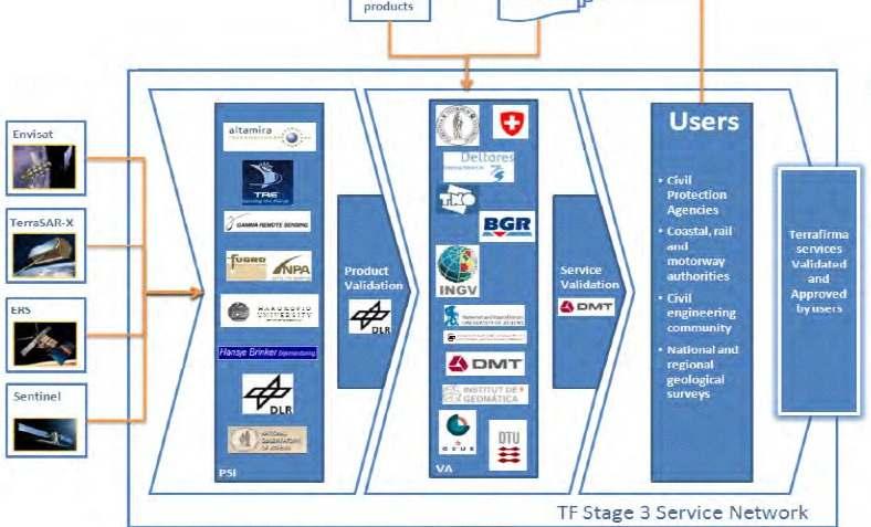
14 Strategy e: to seeks better methodologies for monitoring asting landslides in hazardous areas in the ject Coordinated by ra and N. Casagli ject contains working of ICL European members JRC

15 Integrated Glo Observing Strategy OS GeoHazards Initiative intends to respond fic and operational geospatial information need diction and monitoring of geophysical hazards earthquakes, volcanoes and land instability.

16 lobal Monitoring for ironment and Security (GMES) ES is a European initiative for the implementa formation services dealing with environment a urity ES will be based on observation data received Earth Observation satellites and ground bas rmation. ES is a set of services for European citizens ing to improve their quality of life regarding
17 EC GMES: Preview ational platforms loods indstorms ires arthquake & Volcanoes andslides an-made Risks 58 part from 15 n Scientists - O Industries - E ntion Information and Early Warning C Integrated Project oordinator: ASTRIUM information services to help risk management ased on Core Users needs - Mature and New Services issemination & Training - Pre operational Validation
18 EC GMES: Safer
 ndslides Monitoring in")


19 Core Services andslides Inventory Mapping in Italy, Austria spatial coverage ~ up to 4,000 km2) ndslides Monitoring in Italy, Slovakia (spatial coverage ~2-15 km Rapid Landslides Mapping in support to emergency in and outsi (spatial coverage ~ km2) Real-time Shallow Landslides Forecasting at national level in Ita l coverage: test areas ~40-50 km2; Italy ~300,000 km2)

20 Core Services

21 Rapid Landslide Mapp Rapid Landslide Mapping (RLM) rage: ~ km2 ments: ~6 weeks se: emergency response n Civil Protection Dept.; Disaster esearch Center of the National Cheng Taiwan; Central Geological Survey,
22 Landslide Forecasting Real-time Shallow Landslides Forecasting (RSLF) age: ~300,000 km2 (Italy) ents: ~16-24 weeks e: preparedness/prevention, emergency response ivil Protection Dept. First level - EMPIRICAL MODEL Second level - DETERMINISTIC MOD


23 ESA GMES: Terrafirm MES Service Element Programme motion hazard information service ted throughout Europe via national cal surveys and other institutions. motion hazards:
24
25

26 from prediction to management and governance P6 project - Marie Curie Research Training Netw ramework for the professional development of the ne neration of researchers in the field of hazard and ris management ve: to develop an ed understanding of in hydrophological hazards and is knowledge to longhabitation with such
27
28


29 Cosmo LM TLS Radar imagery Optical imagery
30
31
32
33

34 PSInSAR GBInSAR Hyperspectral Laser scanning
35
36

37 ca. 500 pre-registered participants from 66 countries
38
39
40 Science and technical dvancements and innovation ordinating activities (HFA1): ICL, IPL, FP7, GME nitoring (HFA2): remote sensing dicting and warning (HFA2): Landslide forecas dels based on rainfalls or deformation time ser ucation, advocacy and awareness (HFA3): train tworks FP7 MC RTN, UNITWIN, Laram School ndslide School Network
41 Major gaps in Society lobal level: poor resources with respect to othe ks, lower attention gional level: low risk percepiton and awarene or know how in developing countries tional level: lack of national inventories, spars ta, difficulties in modeling, insufficient preventio cal level: low resilience of local communities, arce preparedness, insufficient education and
42 Main gaps in science and technical knowledge of systematic inventories and catalogues culties in triggering models culties in quantitative risk assessment tionships with other hazards and multirisk ssment spatial and temporal resolution of EO systems effectiveness of engineering risk reduction
43
44 Thank you
M. Mikoš. Faculty of Civil and Geodetic Engineering, University of Ljubljana, Ljubljana, Slovenia
 Proceedings of the Mediterranean Meeting on Monitoring, modelling and early warning of extreme events triggered by heavy rainfalls. PON 01_01503 - MED-FRIEND project University of Calabria, Cosenza (Italy),
The PREVIEW project: general objectives and an overview of the landslides platform
 The PREVIEW project: general objectives and an overview of the landslides platform Risk Mitigation for Earthquakes and Landslides Giacomo Falorni Earth Sciences Dept. University of Firenze 19-20 July 2007
The Safeland Project General Overview and Monitoring Technology Development
 Ber. Geol. B. A., 82, ISSN 1017 8880 Landslide Monitoring Technologies & Early Warning Systems The Safeland Project General Overview and Monitoring Technology Development The SafeLand Consortium a), N.
GMES EURORISK Geo-information services for natural and man-made risks management
 GMES EURORISK Geo-information services for natural and man-made risks management 8/11/2004 EURORISK A European scale approach for developing, delivering and operationally exploiting new information services
Assistant Professor, University of Zagreb (Faculty of Mining, Geology and Petroleum Engineering)
") Proposal of Adriatic-Balkan ICL Network 1. Name of Network Adriatic-Balkan ICL Network 2. Name of Proposer Dr. Snježana Mihalić and Prof. Željko Arbanas Affiliation: position Dr. Snježana Mihalić Assistant
Proposal of Adriatic-Balkan ICL Network 1. Name of Network Adriatic-Balkan ICL Network 2. Name of Proposer Dr. Snježana Mihalić and Prof. Željko Arbanas Affiliation: position Dr. Snježana Mihalić Assistant
Global Monitoring for Environment and Security (GMES)
") Global Monitoring for Environment and Security (GMES) Satellite Earth Observation for the Emergency Services Dr Nick Veck Presentation to the G-STEP Launch Univ. of Leicester 19 th June 2009 Contents of
Global Monitoring for Environment and Security (GMES) Satellite Earth Observation for the Emergency Services Dr Nick Veck Presentation to the G-STEP Launch Univ. of Leicester 19 th June 2009 Contents of
World Meteorological Organization
 World Meteorological Organization Opportunities and Challenges for Development of Weather-based Insurance and Derivatives Markets in Developing Countries By Maryam Golnaraghi, Ph.D. Head of WMO Disaster
IGOS Geohazards: toward an improved use of Earth Observations for Geohazards mitigation
 IGOS Geohazards: toward an improved use of Earth Observations for Geohazards mitigation Scientific and Technical Subcommittee session Vienna, 15th February 2007 Gonéri Le Cozannet IGOS Geohazards Bureau
Landslide Research and Risk Reduction for Advancing Culture of Living with Natural Hazards
 Website: www.wlf4.org Landslide Research and Risk Reduction for Advancing Culture of Living with Natural Hazards Call for Abstracts 29 May - 2 June 2017 Venue: Cankarjev dom Cultural and Congress Centre
Department of Earth Sciences, University of Firenze
 Department of Earth Sciences, University of Firenze Via La Pira, 4, 50121, Firenze, Italy http://www.dst.unifi.it/ Outline The Earth Sciences Department of the University of Firenze has been recently recognized
GEO Geohazards Community of Practice
 GEO Geohazards Community of Practice 1) Co-Chair of GHCP With input from: Stuart Marsh, GHCP Co-Chair Francesco Gaetani, GEO Secretariat and many GHCP contributors 1) Nevada Bureau of Mines and Geology
Joint RA II/V Workshop on WIGOS for DRR - The Jakarta Declaration - (12-14 October, Jakarta, Indonesia) NMSC/KMA
 NMSC/KMA") Joint RA II/V Workshop on WIGOS for DRR - The Jakarta Declaration - (12-14 October, Jakarta, Indonesia) /KMA dolong@korea.kr Background Enhancement of Member s capabilities for weather forecasts and warnings
Joint RA II/V Workshop on WIGOS for DRR - The Jakarta Declaration - (12-14 October, Jakarta, Indonesia) /KMA dolong@korea.kr Background Enhancement of Member s capabilities for weather forecasts and warnings
FINDINGS OF THE ARCTIC METEOROLOGY SUMMIT
 FINDINGS OF THE ARCTIC METEOROLOGY SUMMIT 2018 WWW.FMI.FI CHAIR S SUMMARY: 1 2 3 We need to be curious to explore the known unknowns. Meteorology is an elemental part of international collaboration in
IPL Project (IPL - 196) Annual Report Form 2017
 Annual Report Form 2017") Date of Submission 26/03/2017 IPL Project (IPL - 196) Annual Report Form 2017 1 January 2016 to 31 December 2016 1. Project Number (approved year) and Title, IPL-196 (2015) Development and applications
Date of Submission 26/03/2017 IPL Project (IPL - 196) Annual Report Form 2017 1 January 2016 to 31 December 2016 1. Project Number (approved year) and Title, IPL-196 (2015) Development and applications
ICL and its Efforts Toward a Safer Future
 A Programme of the ICL for ISDR Background of the ISDR-ICL Sendai Partnerships 2015-2025 for Global Promotion of Understanding and Reducing Landslide Disaster Risk ICL and its Efforts Toward a Safer Future
Research infrastructures in FP7: Seismology and Geophysics
 Research infrastructures in FP7: Seismology and Geophysics Domenico Giardini, ETHZ Internation Workshop on Disaster Risk Reduction Bruxelles 29-30 October, 2009 EC FP7 2007-2013 Seven-year targeted program
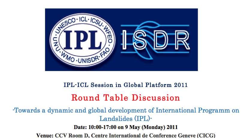
Round Table Discussion
 New!! http://www.iplhq.org/ IPL-ICL Session in Global Platform 2011 Round Table Discussion -Towards a dynamic and global development of the International Programme on Landslides (IPL)- Date : 10:00-17:00
Asia-Pacific ground-base Optical Satellite Observation System APOSOS
 Asia-Pacific ground-base Optical Satellite Observation System APOSOS Center for Research and Application of Space Debris National Astronomical Observatories, CAS GUO Xiaozhong Oct 2011 Outline Space debris
Space Weather & Critical Infrastructures
 Space Weather & Critical Infrastructures Italy Organisers EC JRC, MSB, UK Met Office Date and Venue 29-30 November 2016, JRC Ispra, Background Our modern technological infrastructures on the ground and
Copernicus Overview and Emergency Management Service
 Copernicus Overview and Emergency Management Service Frédéric BASTIDE European Commission Open informal session of the United Nations Inter-Agency Meeting on Outer Space Activities 12 March 2013, Geneva
RESAP Progress Report
 RESAP Progress Report December 2016 to October 2017 Presentation to the Twenty-first session of the Intergovernmental Consultative Committee on the Regional Space Applications Programme for Sustainable
Supporting GPSC Cities with Satellite Earth Observation for Sustainable Urban Development
 Supporting GPSC Cities with Satellite Earth Observation for Sustainable Urban Development Global Platform for Sustainable Cities African Regional Workshop 14 May 2018 AfDB Headquarters Abidjan, Côte d'ivoire
INCA CE: Integrating Nowcasting with crisis management and risk prevention in a transnational framework
 INCA CE: Integrating Nowcasting with crisis management and risk prevention in a transnational framework Yong Wang ZAMG, Austria This project is implemented through the CENTRAL EUROPE Programme co-financed
Final Presentation on Disaster Risk Management in Japan. Through ADRC V. R Programme. Main Findings and Action Plan:
 Final Presentation on Disaster Risk Management in Japan Through ADRC V. R Programme Main Findings and Action Plan: Problem/Hazard and Disaster in Japan Good Practiced on Disaster Risk Management in Japan
Space research. Horizon Work Programme. "Countdown to Horizon 2020 Space" Earth Observation topics. Brussels, 12 December 2013
 Space research Horizon 2020 - Work Programme "Countdown to Horizon 2020 Space" Earth Observation topics Brussels, 12 December 2013 richard.gilmore@ec.europa.eu Table of contents FP/Copernicus - general
Space Applications for Disaster Risk Reduction and Sustainable Development
 Space Applications for Disaster Risk Reduction and Sustainable Development Space Applications Section (SAS) ICT and Disaster Risk Reduction Division (IDD) UNESCAP Contents I. RESAP Activities 2016-2017
Effective Utilization of Synthetic Aperture Radar (SAR) Imagery in Rapid Damage Assessment
 Imagery in Rapid Damage Assessment") Effective Utilization of Synthetic Aperture Radar (SAR) Imagery in Rapid Damage Assessment Case Study Pakistan Floods SUPARCO M. Maisam Raza, Ahmad H. Rabbani SEQUENCE Flood Monitoring using Satellite
Effective Utilization of Synthetic Aperture Radar (SAR) Imagery in Rapid Damage Assessment Case Study Pakistan Floods SUPARCO M. Maisam Raza, Ahmad H. Rabbani SEQUENCE Flood Monitoring using Satellite
SDG s and the role of Earth Observation
 SDG s and the role of Earth Observation Christian Heipke IPI - Institute for Photogrammetry and GeoInformation Leibniz Universität Hannover Germany Secretary General, ISPRS 1. No Poverty 2. Zero Hunger
Innovative Ways to Monitor Land Displacement
 ARTICLE Innovative Ways to Monitor Land Displacement When people think about landslides, they usually imagine large mud streams which cause considerable loss of life. Whereas such large-scale disasters
Emergency Management Service (EMS) mapping
 mapping") GMES Emergency Management Service (EMS) mapping Frédéric BASTIDE GMES unit, European Commission UN-SPIDER Expert Meeting: "Crowdsource Mapping for Disaster Risk Management and Emergency Response" 3-5 December,
GMES Emergency Management Service (EMS) mapping Frédéric BASTIDE GMES unit, European Commission UN-SPIDER Expert Meeting: "Crowdsource Mapping for Disaster Risk Management and Emergency Response" 3-5 December,
The Third UN-GGIM-AP Plenary Meeting. Use of Geospatial Information in Disaster and Coordination among NDMA and Relevant Organizations/Stakeholders
 The Third UN-GGIM-AP Plenary Meeting Use of Geospatial Information in Disaster and Coordination among NDMA and Relevant Organizations/Stakeholders Bali Indonesia 10 November 2014 Bernardus Wisnu Widjaja
Disaster Risk Reduction in Survey for Seismic Protection of MES
 Survey for Seismic Protection Ministry of Emergency Situations of Republic of Armenia Disaster Risk Reduction in Survey for Seismic Protection of MES Syuzanna Kakoyan Leading specialist at the Department
Project Progress and Achievements
 IPA PROJECT BUILDING RESILIENCE TO DISASTERS IN WESTERN BALKANS AND TURKEY Project Progress and Achievements 15 16 April 2014 Meeting on enhancing hydrological data management and exchange procedures in
Sentinel Asia Tsunami Working Group
 Sentinel Asia Tsunami Working Group Co-Chairman: Prof. Shunichi Koshimura Abdul Muhari, PhD 4 th Joint Project Team Meeting (JPTM 2017): Sentinel Asia STEP 3 Abdul MUHARI, PhD Ministry of Marine Affairs
Copernicus Information & Training Session
 Copernicus Information & Training Session Copernicus Emergency Management Service Dora Aifantopoulou GEOAPIKONISIS S.A.P.GE. Copernicus EU Copernicus EU Copernicus EU www.copernicus.eu Athens 07.10.2016
Earth Observation and GEOSS in Horizon Copernicus for Raw Material Workshop 5 th September 2016
 Earth Observation and GEOSS in Horizon 2020 Copernicus for Raw Material Workshop 5 th September 2016 Gilles OLLIER Head of Sector -Earth observation Directorate Environment Unit I.4 Climate Actions and
Introduction to the Training Course
 Introduction to the Training Course Trainer Khaled Mashfiq 14 / Nov / 2017 Training Module A1 Session 1 Introduction to the Use of Geospatial Information Technology for Drought Risk Management Phnom Penh,
Contribution to global Earth observation from satellites
 Contribution to global Earth observation from satellites - JAXA s Earth Observation strategy - April 16, 2008 Makoto Kajii Japan Aerospace Exploration Agency Earth Observation Summits and GEOSS 1 st EO
Urban areas & climate change
 Urban areas & climate change Paolo Gamba University of Pavia University of Pavia The UNIPV TLC & RS Lab is a dynamic research group developing in the past years many techniques devoted to the analysis
Open data integration: from satellite to UAV for protection of built environment. The archaeological site in the Centa River bed in Albenga
 Open data integration: from satellite to UAV for protection of built environment. The archaeological site in the Centa River bed in Albenga L. Barazzetti a, R. Brumana a, B. Cuca a,b, M. Previtali a, R.
GMES Initial Operations- Network for Earth Observation Research and Training
 GMES Initial Operations- Network for Earth Observation Research and Training Sybrand van Beijma, Dr. Virginia Nicolás-Perea, Prof. Heiko Balzter Centre for Landscape and Climate Research, University of
World Meteorological Organization
 Appendix VI Presentation on disaster risk reduction brainstorming session (1) World Meteorological Organization WMO DRR Programme Dieter C. Schiessl Director, Weather and Disaster Risk Reduction Services
Progress Report Form of WCoEs 2014
 Date of Submission 25/02/2015 Progress Report Form of WCoEs 2014 3 June 2014 to 31 December 2014 1. Short Title of WCoE: Advanced Technologies for LandSlides (ATLaS) 2. Name of Institution (Name of leader
ACTION PLAN FOR WORLD HERITAGE IN LATIN AMERICA AND THE CARIBBEAN ( )
") Annex ACTION PLAN FOR WORLD HERITAGE IN LATIN AMERICA AND THE CARIBBEAN (2014-2024) The current Regional Action Plan for Latin America and the Caribbean for 2014-2024 has been elaborated by the State Parties
Annex ACTION PLAN FOR WORLD HERITAGE IN LATIN AMERICA AND THE CARIBBEAN (2014-2024) The current Regional Action Plan for Latin America and the Caribbean for 2014-2024 has been elaborated by the State Parties
Urban Climate Resilience
 Urban Climate Resilience in Southeast Asia Partnership Project Introduction Planning for climate change is a daunting challenge for governments in the Mekong Region. Limited capacity at the municipal level,
Space for Smarter Government Programme
 Space for Smarter Government Programme Development of Operational National Satellite Imaging Flood Mapping Capability Project Number: 59287-454144 Web: http://www.spaceforsmartergovernment.uk/ Email: ssgp@sa.catapult.org.uk
Economic and Social Council
 United Nation E/C.20/2012/4/Add.1 Economic and Social Council Distr.: General 2 July 2012 Original: English Committee of Experts on Global Geospatial Information Management Second session New York, 13-15
The WMO Integrated Global Observing System (WIGOS), current status and planned regional activities
, current status and planned regional activities") The WMO Integrated Global Observing System (WIGOS), current status and planned regional activities Dr. Lars Peter Riishojgaard WMO Secretariat, Geneva Outline Introduction to WIGOS WMO The Rolling Review
The WMO Integrated Global Observing System (WIGOS), current status and planned regional activities Dr. Lars Peter Riishojgaard WMO Secretariat, Geneva Outline Introduction to WIGOS WMO The Rolling Review
The ISDR-ICL Sendai Partnerships : Background and Content
 The ISDR-ICL Sendai Partnerships 2015 2025: Background and Content Kyoji Sassa Abstract The International Consortium on Landslides proposed the ISDR-ICL Sendai Partnerships 2015 2025 for global promotion
GEO-VIII November Geohazard Supersites and Natural Laboratories Progress Report. Document 9
 GEO-VIII 16-17 November 2011 Geohazard Supersites and Natural Laboratories Progress Report Document 9 This document is submitted to GEO-VIII for information. Geohazard Supersites and Natural Laboratories
The first 5 years of IPL and IPL-ICL session held on 9 May Kyoji Sassa Executive Director International Consortium on Landslides (ICL)
") The first 5 years of IPL and IPL-ICL session held on 9 May Kyoji Sassa Executive Director International Consortium on Landslides (ICL) 11:45-12:00 on 10 May 2011 Ignite Presentation at Market Place, Global
The first 5 years of IPL and IPL-ICL session held on 9 May Kyoji Sassa Executive Director International Consortium on Landslides (ICL) 11:45-12:00 on 10 May 2011 Ignite Presentation at Market Place, Global
Role of International Ocean Institute (IOI) to Promote Multi-Level and Multi-Coordination of Capacity Building on
 to Promote Multi-Level and Multi-Coordination of Capacity Building on") Role of International Ocean Institute (IOI) to Promote Multi-Level and Multi-Coordination of Capacity Building on Ocean Governance and Sustainable Development By Cherdsak Virapat Executive Director International
Role of International Ocean Institute (IOI) to Promote Multi-Level and Multi-Coordination of Capacity Building on Ocean Governance and Sustainable Development By Cherdsak Virapat Executive Director International
CapacityAssessmentofNational MeteorologicalandHydrological ServicesinSupportof DisasterRiskReduction
 CapacityAssessmentofNational MeteorologicalandHydrological ServicesinSupportof DisasterRiskReduction Analysisofthe2006WMO DisasterRiskReduction Country-levelSurvey Capacity Assessment of National Meteorological
Strategic Planning and Management of MMD
 Fifth Technical Conference on Management of Meteorological & Hydrological Services In Regional V (South-West Pacific) Strategic Capacity Development of NMHS s in RAV Malaysia Meteorological Department
I&CLC2000 in support to new policy initiatives (INSPIRE, GMES,..)
") I&CLC2000 in support to new policy initiatives (INSPIRE, GMES,..) Manfred Grasserbauer, Director Joint Research Centre Institute for Environment and Sustainability 1 IMAGE 2000 European mosaic of satellite
I&CLC2000 in support to new policy initiatives (INSPIRE, GMES,..) Manfred Grasserbauer, Director Joint Research Centre Institute for Environment and Sustainability 1 IMAGE 2000 European mosaic of satellite
Challenges and Successes in Sharing Geospatial Data in Africa
 Challenges and Successes in Sharing Geospatial Data in Africa 2018 GeoNode Summit Torino, Italy March 26-28, 2018 Bernard Justus Muhwezi Manager, Geo-Information Services Uganda Bureau of Statistics, Kampala,
Report of the Regional Committee of UN-GGIM for Asia and the Pacific (UN-GGIM-AP)
") Report of the Regional Committee of UN-GGIM for Asia and the Pacific (UN-GGIM-AP) At the Eighth Session of UN-GGIM UN Headquarters, New York, 1 3 August 2018 About UN-GGIM-AP One of the five regional committees
Report of the Regional Committee of UN-GGIM for Asia and the Pacific (UN-GGIM-AP) At the Eighth Session of UN-GGIM UN Headquarters, New York, 1 3 August 2018 About UN-GGIM-AP One of the five regional committees
New COST Action: Towards a European Network on Chemical Weather Forecasting and Information Systems
 New COST Action: Towards a European Network on Chemical Weather Forecasting and Information Systems Proposer: Mikhail Sofiev Finnish Meteorological Institute Historical background EUMETNET Workshop on
What are the social, technical, environmental and economic benefits and opportunities of accessing and sharing geodetic data?
 What are the social, technical, environmental and economic benefits and opportunities of accessing and sharing geodetic data? Graeme Blick Group Manager Positioning and Resilience Land Information New
The Integrated Ge spatial Information Framework to the strengthening of NSDI, Mongolia
 Young Geospatial Professionals Summit 21 NOV 2018 The Integrated Ge spatial Information Framework to the strengthening of NSDI, Mongolia BAYARMAA ENKHTUR Geospatial information and technology department
The Joint Programming Initiative on Cultural Heritage (JPICH): European perspective
: European perspective") COPERNICUS FOR CULTURAL HERITAGE Copernicus User Forum Industry Workshop Brussels, 24 April 2017 The Joint Programming Initiative on Cultural Heritage (JPICH): European perspective Cristina Sabbioni CNR,
COPERNICUS FOR CULTURAL HERITAGE Copernicus User Forum Industry Workshop Brussels, 24 April 2017 The Joint Programming Initiative on Cultural Heritage (JPICH): European perspective Cristina Sabbioni CNR,
Yev Kontar. Illinois State Geological Survey, University of Illinois at Urbana-Champaign
 Addressing Caribbean Geophysical Hazards through the Continuously Operating Caribbean GPS Observational Network (COCONet) and International Ocean Drilling Program (IODP) Yev Kontar Illinois State Geological
Use of geo-referenced data for DRM in Central Asia, problems and prospective
 Use of geo-referenced data for DRM in Central Asia, problems and prospective Dr. Akylbek Chymyrov Director, Kyrgyz Center of Geoinformation Systems Member of the Public Supervisory Board MES KR KSUCTA,
Chapter 2 Land Use Management and Risk Communication
 Chapter 2 Land Use Management and Risk Communication Michiko Banba Abstract Land use represents a relationship between natural and urban environment. Land use management is the way of managing land use
WMO Priorities and Perspectives on IPWG
 WMO Priorities and Perspectives on IPWG Stephan Bojinski WMO Space Programme IPWG-6, São José dos Campos, Brazil, 15-19 October 2012 1. Introduction to WMO Extended Abstract The World Meteorological Organization
Space-based technology and applications and space science for humanitarian affairs, environment and security
 Space-based technology and applications and space science for humanitarian affairs, environment and security LUC ST-PIERRE United Nations Office for Outer Space Affairs United Nations Office at Vienna
WMO/WWRP FDP: INCA CE
 WMO/WWRP FDP: INCA CE Yong Wang ZAMG, Austria This project is implemented through the CENTRAL EUROPE Programme co-financed by the ERDF INCA CE: implementation over Central Europe A Nowcasting Initiative
Interpretive Map Series 24
 Oregon Department of Geology and Mineral Industries Interpretive Map Series 24 Geologic Hazards, and Hazard Maps, and Future Damage Estimates for Six Counties in the Mid/Southern Willamette Valley Including
INCA-CE: The Challenge of Severe Weather Warnings. Yong Wang, ZAMG
 INCA-CE: The Challenge of Severe Weather Warnings Yong Wang, ZAMG Severe Weather and Impact The need of civil society and economy Save Life! Save Cost! Reduce Risks and impacts! The Challenge of Severe
Early Warning > Early Action: The Next Frontier. Dr. Arame Tall Climate Services- Global Coordinator, Champion
 Early Warning > Early Action: The Next Frontier Dr. Arame Tall Climate Services- Global Coordinator, Champion a.tall@cgiar.org 2 3/21/11 The Challenge: Bridging The Gap Seasonal Precipitation Forecast
Journey of supporting CSNs to establish Geo-DRM
 Regional Workshop on Geo-referenced Information Systems for Disaster Risk Management (Geo-DRM) 26-27 June 2014 Bangkok, Thailand Journey of supporting CSNs to establish Geo-DRM Keran Wang Chief, Space
Involvement of the Geological Survey of Slovenia in the field of natural hazard risk management
 Involvement of the Geological Survey of Slovenia in the field of natural hazard risk management Špela Kumelj, Mateja Jemec-Auflič, Jernej Jež, Tina Peternel, Blaž Milanič Geohazard group, GeoZS COMLAND
Workshop on hydrological modelling, forecasting and warnings
 WMO RAVI Hydrological Forum 2016 Workshop on hydrological modelling, forecasting and warnings 20 September 2016, Oslo, Norway Norwegian Water Resources and Energy Directorate (NVE) Middelthunsgate 29,
Development of Global Map for GEOSS SBAs US-09-03a
 Development of Global Map for GEOSS SBAs US-09-03a UIC User Engagement Session 2 November, 2010 Yoshikazu FUKUSHIMA Secretariat General of International Steering Committee for Global Mapping Geospatial
Funded by Japan Government through UN ESCAP and BMKG
 METEOROLOGY & COAST RADIO SERVICES MINISTRY OF METEOROLOGY, ENERGY, INFORMATION,DISASTER MANAGEMENT, ENVIRONMENT, CLIMATE CHANGE AND COMMUNICATION KINGDOM OF TONGA P. O. Box 845, Domestic Terminal, Fua
Objectives and hypotheses. Remote sensing: applications for landslide hazard assessment and risk management. Ping Lu (University of Firenze) Methods
 Methods") Topical Workshop Remote sensing: applications for landslide hazard assessment and risk management Ping Lu (University of Firenze) Supervisors: Prof. Nicola Casagli; Prof. Filippo Catani (Unifi) Dr. Veronica
Topical Workshop Remote sensing: applications for landslide hazard assessment and risk management Ping Lu (University of Firenze) Supervisors: Prof. Nicola Casagli; Prof. Filippo Catani (Unifi) Dr. Veronica
The Role of Geospatial Information in Disaster Risk Reduction
 3rd High Level Forum on UN Global Geospatial Information Management in Beijing, Session 3: Climate Change and Disaster Mitigation 23 October 2014 The Role of Geospatial Information in Disaster Risk Reduction
The Swedish National Geodata Strategy and the Geodata Project
 The Swedish National Geodata Strategy and the Geodata Project Ewa Rannestig, Head of NSDI Co-ordination Unit, Lantmäteriet, ewa.rannstig@lm.se Ulf Sandgren, Project Manager Geodata Project, Lantmäteriet,
PAGASA s Expectations of New-generation Satellites for Hazard Monitoring
 Country Report Philippines PAGASA s Expectations of New-generation Satellites for Hazard Monitoring VICENTE P. PALCON, JR. (Assistant Weather Services Chief) Weather Division- PAGASA DOST Email: vppalconjr@pagasa.dost.gov.ph
Advancing Flood Detection and Preparedness through GEOSS Water Services
 Advancing Flood Detection and Preparedness through GEOSS Water Services David K. Arctur University of Texas at Austin Open Geospatial Consortium (OGC) CAHMDA/DAFOH Joint Workshop University of Texas at
Ms. Latoya Regis. Meteorologist Hydrometeorological Service, Guyana
 Ms. Latoya Regis Meteorologist Hydrometeorological Service, Guyana Background Ninety percent (90%) of Guyana s population resides along the (Atlantic) Coast, which is below mean sea level and accounts
Publishable Summary. Summary Description of the project context and main objectives
 Publishable Summary Summary Description of the project context and main objectives Tsunamis are low frequency but high impact natural disasters. In 2004, the Boxing Day tsunami killed hundreds of thousands
EuroGeoSurveys & ASGMI The Geological Surveys of Europe and IberoAmerica
 EuroGeoSurveys & ASGMI The Geological Surveys of Europe and IberoAmerica Geological Surveys, what role? Legal mandate for data & information: Research Collection Management Interpretation/transformation
SOUTHEAST ASIAN SUBSEASONAL TO SEASONAL (SEA S2S) PROJECT
 PROJECT") SOUTHEAST ASIAN SUBSEASONAL TO SEASONAL (SEA S2S) PROJECT CONCEPT NOTE FOR SEA S2S FIRST WORKSHOP Feb 27 3 Mar 2017 CENTRE FOR CLIMATE RESEARCH SINGAPORE (CCRS) METEOROLOGICAL SERVICE SINGAPORE (MSS) Background
SOUTHEAST ASIAN SUBSEASONAL TO SEASONAL (SEA S2S) PROJECT CONCEPT NOTE FOR SEA S2S FIRST WORKSHOP Feb 27 3 Mar 2017 CENTRE FOR CLIMATE RESEARCH SINGAPORE (CCRS) METEOROLOGICAL SERVICE SINGAPORE (MSS) Background
Implementing the Sustainable Development Goals: The Role of Geospatial Technology and Innovation
 Fifth High Level Forum on UN Global Geospatial Information Management Implementing the Sustainable Development Goals: The Role of Geospatial Technology and Innovation 28-30 November 2017 Sheraton Maria
Cooperation is the key, FIG can facilitate
 Cooperation is the key, FIG can facilitate Mikael Lilje Vice President 2017-2020 Head, Geodetic infrastructure, Swedish mapping, cadastral and land registration authority Presented at the GIS/RS Conference
Weather Climate Science to Service Partnership South Africa
 PROJECTS UNDERWAY Title of the Weather Climate Science to Service Partnership South Africa Together, building on an existing strong partnership, South African Weather Service and the Met Office will build
sentinel-2 COLOUR VISION FOR COPERNICUS
 sentinel-2 COLOUR VISION FOR COPERNICUS SATELLITES TO SERVE By providing a set of key information services for a wide range of practical applications, Europe s Copernicus programme is providing a step
Regional EGM on Community of Practice of Georeferenced Information System. for Disaster Risk Management (Geo-DRM) April 2014, Bangkok, Thailand
 April 2014, Bangkok, Thailand") Regional EGM on Community of Practice of Georeferenced Information System for Disaster Risk Management (Geo-DRM) 23-25 April 2014, Bangkok, Thailand Presented By Mukesh Kumar Keshari Ministry of Home Affairs
Regional EGM on Community of Practice of Georeferenced Information System for Disaster Risk Management (Geo-DRM) 23-25 April 2014, Bangkok, Thailand Presented By Mukesh Kumar Keshari Ministry of Home Affairs
GEONETCast Future Plans at CIMH
 GEONETCast Future Plans at CIMH Operations, Training, Climate Monitoring and Disaster Preparedness WORLD METEOROLOGICAL ORGANIZATION COORDINATION GROUP ON SATELLITE DATA REQUIREMENTS FOR REGION III AND
INSPIREd solutions for Air Quality problems Alexander Kotsev
 INSPIREd solutions for Air Quality problems Alexander Kotsev www.jrc.ec.europa.eu Serving society Stimulating innovation Supporting legislation The European data puzzle The European data puzzle 24 official
Overview of Early Warning Systems and the role of National Meteorological and Hydrological Services
 Overview of Early Warning Systems and the role of National Meteorological and Hydrological Services South Africa Second Experts Symposium on Multi-Hazard Early Warning Systems With focus on the Role of
EuroGEOSS Protected Areas Pilot
 EuroGEOSS Protected Areas Pilot Max Craglia European Commission Joint Research Centre Part 1: the present MyNatura2000 Mobile app. Awareness raising & volunteered data collection. Natura2000 covers 18%
EUMETSAT. A global operational satellite agency at the heart of Europe. Presentation for the Spanish Industry Day Madrid, 15 March 2012
 EUMETSAT A global operational satellite agency at the heart of Europe Presentation for the Spanish Industry Day Madrid, Angiolo Rolli EUMETSAT Director of Administration EUMETSAT objectives The primary
Geohazards and disaster risk reduction
 Geohazards and disaster risk reduction Susanne Sargeant 8 November 2017 Overview University and my PhD Seismology at BGS Learning other skills Working at the interface between science and resilience building
Cataloguing high impact Weather and Climate Events
 Cataloguing high impact Weather and Climate Events Omar Baddour Chief Data Management Applications Divison World Meteorological Organisation Geneva, Switzerland 2 3 Estimating and cataloguing loss & damage
Disaster Risk Reduction and
 6 th ICRM Symposium 2015 Disaster Risk Reduction and 2015/04/23 Resilience in Taipei Outline Natural Disaster and Loss in Taiwan Climate Change and Geohazard Hazard Alert & App Monitoring & Modeling Land
5. Principles. 1. Malaysia is not free from. Kuala Teriang, Langkawi
 5. Principles 1. Malaysia is not free from seismic-induced geohazards. However, the degree and magnitude of the geohazards are relatively small or minor because Malaysia is located in a stable tectonic
- facilitate the preparation of landslide inventory and landslide hazard zonation maps for the city, - development of precipitation thresholds,
 Date of Submission 29.03.2012 IPL Project Proposal Form 2012 (MAXIMUM: 3 PAGES IN LENGTH) 1. Project Title: (2 lines maximum)-introducing Community-based Early Warning System for Landslide Hazard Management
Pacific Geospatial and Surveying Council (PGSC) Geospatial and GNSS CORS Infrastructure Forum. Kuala Lumpur October
 Geospatial and GNSS CORS Infrastructure Forum. Kuala Lumpur October") Pacific Geospatial and Surveying Council (PGSC) Geospatial and GNSS CORS Infrastructure Forum. Kuala Lumpur 16-17 October Beginning and Progress Members PGSC Charter PGSC Strategy 2017-2027 Meetings Geodetic
Pacific Geospatial and Surveying Council (PGSC) Geospatial and GNSS CORS Infrastructure Forum. Kuala Lumpur 16-17 October Beginning and Progress Members PGSC Charter PGSC Strategy 2017-2027 Meetings Geodetic