Core Unit One Patterns & Processes in the Physical Environment
|
|
|
- Solomon May
- 6 years ago
- Views:
Transcription
1 Core Unit One Patterns & Processes in the Physical Environment Examining the relationship between the tectonic & rock cycles, the processes of landform development &human interaction
2 The New Approach A change from existing practice with an almost exclusive focus on landform development Landform development firmly tied to the rock & tectonic cycles. The Unit is mainly concerned with the study of landform development with the emphasis on processes rather than the description of the end product Statements 1.3., 1.4, 1.5 & 1.6 are based on the students understanding of both the rock and tectonic cycles ( 1.1 & 1.2) SYLLABUS, Page 11
3 Integrated Skills Map Interpretation Figure Interpretation Photograph Analysis Statistical Analysis Figure Drawing I.T.
4 Learning Outcomes O.L. p. 9 Explain plate tectonic theory Understand the processes of rock formation, weathering and erosion Explain processes of landform development Show how human activities can affect these processes Understand and use the skills listed to describe the physical environment
5 Learning Outcomes H.L. Detailed understanding of plate tectonic theory Illustrate how crustal structures are created, modified and destroyed by the tectonic cycle Explain & illustrate the continual process of rock formation, change & destruction Explain & illustrate landform development
6 Illustrate how landforms present a balance through time, between endogenic & exogenic forces Assess the impact of human activity on the physical process at work on the landscape Understand & use skills to interpret the physical environment
7 O.L. H.L. 1. Explain Plate Tectonic Theory Detailed understanding 2. Understand processes of rock Creation, modification formation, weathering & erosion & destruction of crustal structures 3. Explain processes of landform devpt----- Explain & illustrate 4. Human activities affect processes Assess the impact of human activity on physical processes 5. Understand & use skills to Understand and use describe skills to interpret 6. Effects of endogenic & exogenic forces on landforms over time
8 7 Statements p The Tectonic Cycle 1.2 The Rock Cycle 1.3 Landform Development (i) 1.4. Landform Development (ii) 1.5. Landform Development (iii) 1.6. Landform Development (iv) 1.7 Human Interaction
9 Regional Settings Landforms & processes should be explained by using local examples as much as possible. Examples can also be tied to selected regional settings
10 Syllabus Language! tfk tfu
11 Multiple Intelligences Debating Problem solving Mapwork Role-play Paired learning Reflection Fieldwork Brainstorming Pattern recognition Photographs / Diagrams Hands-on learning Co-operative group-work Individual research
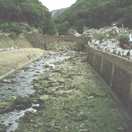
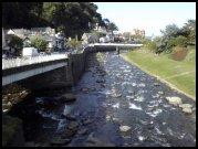
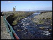
12 Active Approaches to River Processes Elements of an approach Understanding goals Determine previous experience & knowledge Images & Examples New Information Understanding Performances
13 Understanding Goals Students will be able to Identify the main processes of erosion & deposition at work in a river basin Identify and understand the development and evolution of the resulting landforms Explain how these processes can vary due to slope, rock type and climate Link to influence of tectonic cycle
14 UnderstandingPerformances: Draw diagrams to illustrate main landforms Identify these landforms on OS Maps Draw a long profile of a river Discuss & differentiate between the different processes at work Link the topic to 1.2 (Rock Cycle) to identify & discuss the processes of weathering at work in the different stages of the river basin
15 Typical understanding performances would include an ability to. Explain in your own words Analyse the controlling factors Debate or argue different point of view Use skills to deal with different forms of spatial information Apply the topic or issue to another setting
16 Active Approaches to Rivers Understanding Goals OOOOOOOO Understanding Performance
17 Previous Knowledge/Experience Students visualise rivers with closed eyes Class brainstorms rivers and students call out the terms Teacher records terms on OHP or blackboard Teacher checks understanding of terms Class sorts terms into groups e.g. processes, landforms etc.
18 Previous Knowledge/Experience Matching exercises - match descriptions, photographs or diagrams with river terms Sequencing exercises - put terms or diagrams into sequence Worksheets on rivers Visit a local river, if convenient Observe and measure elements of the river such as bed, banks, landforms, speed, depth, width, discharge - (H/O)
19 Images and Examples Flooding activity examine photographs (ground and aerial) of the Lynmouth flood Group activity - put Lynmouth photographs onto a large sheet of paper - students annotate them with questions and comments Individual activity - answering questions e.g. What happened before the photograph was taken? What happened after it was taken?

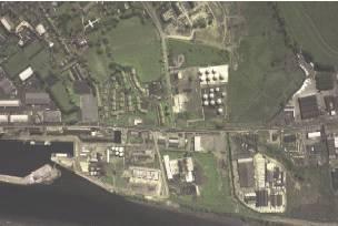
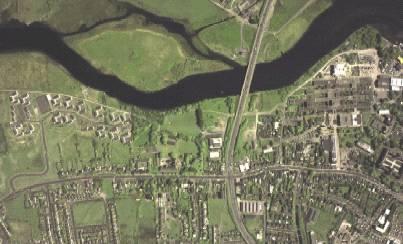
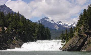
20 Lynmouth A&B
21 Images and Examples Rivers on atlas and OS maps Locate important rivers in chosen regions e.g Ganges and Brahmaputra Locate features, watershed, basin, source, tributaries etc. Calculate area of a drainage basin Rank order the streams
22 Images and Examples Do contour pattern recognition activities -use a melon to show contours - (H/O) Look at profile section of Shannon video Draw simple profiles - (H/O) Draw a profile from an OS map Examine the profile Identify different parts of the profile CP&LFS PFS
23 Images and Examples PHOTOGRAPH ACTIVITY Group examines a selection of photographs of river landforms - v-shaped valley, waterfalls, meanders, floodplains, levees and deltas Group decides where each landform is likely to be located on the profile Group gives reasons for their choices using evidence from the photographs Features in photographs are named if not known
24 New Information Formation of landforms texts, diagrams and videos used as references extensively Emphasis on processes Practical demonstrations for processes of erosion Dirty milk bottle cleaned with sand and water to show abrasion Jif to clean graffitti from a desk Rubex in water to show solution
25 New Information Water dripping from school roof to show hydraulic action Handling gravel and scree to show effects of attrition Sand on a board tilted to show mass movement of debris Practical demonstrations of processes of deposition Use a jar with water and sand - shake the jar and the sand moves stop and it is deposited
26 New Information Add more sand and you get more deposition Add barium sulphate to a cloudy solution to clear it and show flocculation Bed & Bank friction vs Stream Velocity Two pieces of guttering Sandpaper glued to one A jar of dry sand
27 New Information Landform formation shown through a succession of simple diagrams as follows: Examples of the formation of a V- shaped valley and a waterfall follow
28 Formation of a V-shaped Valley Little load so hydraulic action and solution Valley sides exposed to weather River downcutting
29 Formation of a V-shaped Valley Weathering breaks up exposed rock and debris moves downslope River now has load for abrasion
30 Formation of a Waterfall How rock type and slope affect processes P A step is formed where the rock types meet Resistant Rock Less Resistant Rock
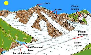
31 Formation of a Waterfall Resistant Rock Increased slope increases hydraulic action and abrasion Less Resistant Rock Deep plunge pool
32 Understanding Performances Map reading skills - feature recognition - profile drawing - identifying different stages Being able to discuss and differentiate between different process at work Group work - a pack is given to each group which contains an OS map and photographs The group must identify the features in the photographs
33 Understanding Performances The group must classify each of them as either erosional or deposional features The group must explain the process involved in the formation of each of the features The group must identify and locate the features on the OS map Each group must report back to the class with individuals taking responsibility for different features

34 Understanding Performances D C
35 Understanding Performance Human Interference
36 SEQUENCING Sort the following statements into a logical order. Justify decisions. A: The ground became saturated. B: Sand bags were sent out by the council. C: People were killed and injured. D: A lot of people did not hear the flood warning because it was at night E: There was a very heavy thunderstorm on the night of 15th Aug F: The discharge of the River Lyn rose gradually G: The River Lyn reached it s peak discharge H: A heavy thunderstorm was forecast by the Met. Office I: The force of the river knocked down bridges and houses were destroyed J: The discharge of the river Lyn rose rapidly.

37 Understanding Performances OS Maps: Sheet 37 X-sn


38 Matching cards This feature has a steep backwall etc Weathering Nivation Plucking Abrasion Cirque / Tarn / Arete
39 threeriversproject.ie
40
41
42 Fundamental Online Textbook (Chapter 10)
43 EXAMINATION QUESTIONS Some possible examples! (Based on HL 80m/qn)
44 Short Answer Questions Not Describe / Explain Not Statement + Development Not folder type question Emphasis on skills Command words: Identify / name / list Brief, focused, constructive response.

45 Short Answer Question (b) (a) (b) Identify the landforms (a) and (b). State if they are formed by erosion or deposition. (c) Identify the type of material at (c).
46 Short Answer Question Examine the hydrograph for the Shannon. Which month has (i) highest discharge (ii) lowest discharge Calculate (i) the total annual discharge (ii) the average monthly discharge

47 Short Answer Question In what direction is the Belderg River flowing? Identify the river mouth by a six-figure grid reference. Name any two river landforms that you can identify on the map extract.
48 Structured Multi-part Question (a ) Examine the sketch map above and identify the landforms marked A, B, C and D. (8m) (b) Refer to the OS map and link each of the above features to one of the following grid references: A A A A (12m)
49 (c) (D) Explain the processes that influence the development of any landform found in the upper course of a river. (20m) Describe any one way in which a relative change in land or sea level would affect the landscape of the lower course of a river. (20m)
50 (e) Humans have always tried to control the natural processes active along the course of a river valley. Examine this statement, referring to one example you have studied. (20m) ********************
51 Structured Multi-part Question (a) Examine the Aerial Photograph and answer the following questions (i) At what stage is the river? (ii) Identify any two river landforms. (iii) Identify two ways in which humans have made use of the river. (10m)
52 (b) (c) Examine the hydrograph of the Lee: (i) What was the highest discharge? (ii) What is the bankful discharge? (iii) After how many hours rainfall did peak discharge occur? (iv) Calculate the total rainfall in mms (10m) Explain, with the aid of a diagram, the processes involved in the formation of any one landform found along the upper course of a river. (20m)
53 (d) (e) Examine two ways by which river processes can have a positive economic impact on human economic activities. (20m) Examine one cause and one effect of flooding on a community. Refer in your answer to an example you have studied. (20m)
Physical landscapes River landscapes in the UK
 Physical landscapes River landscapes in the UK The shape of river valleys change s as rivers flow downstream - PROCESSES Erosion Abrasion or corrasion Attrition Hydraulic Action Solution or corrosion Deposition
The Upper Course of a River
 The Upper Course of a River I. Introduction A river is split along the long profile into three different sections; the upper, middle and lower course. As GCSE students you are expected to know the characteristics
Erosion Surface Water. moving, transporting, and depositing sediment.
 + Erosion Surface Water moving, transporting, and depositing sediment. + Surface Water 2 Water from rainfall can hit Earth s surface and do a number of things: Slowly soak into the ground: Infiltration
Teacher s Pack Key Stage 3 GEOGRAPHY
 Teacher s Pack Key Stage 3 GEOGRAPHY Geography Key Stage 3 Fieldwork Worksheet Rivers: 1. Is the water fresh or salty? (test its resistance or specific gravity) 2. Do you know where the water is coming
Chapter 11. Rivers: Shaping our landscape
 Chapter 11 Rivers: Shaping our landscape Learning outcomes In this presentation you will learn: Common terms associated with rivers About the three stages of a river About the processes of river erosion
River Processes. A) Write definitions for the terms erosion, transportation & deposition.
 Write definitions for the terms erosion, transportation & deposition.") River Processes Lesson Aims To learn what is erosion, transportation and deposition. To learn which processes carry out erosion, transportation and deposition in river systems. Within rivers a number of
River Processes Lesson Aims To learn what is erosion, transportation and deposition. To learn which processes carry out erosion, transportation and deposition in river systems. Within rivers a number of
Streams. Stream Water Flow
 CHAPTER 14 OUTLINE Streams: Transport to the Oceans Does not contain complete lecture notes. To be used to help organize lecture notes and home/test studies. Streams Streams are the major geological agents
Climate, Hazards and Distinctive Landscapes 3 days
 GCSE Geography OCR B Climate, Hazards and Distinctive Landscapes 3 days Covers all fieldwork requirements within Our Natural World, enabling students to get the grades they want within Section B of the
Landscape Development
 CHAPTER 22 Landscape Development Chapter Summary Landscapes are described in terms of their topography: elevation, the altitude of the surface of the Earth above sea level; relief, the difference between
Year 6. Geography. Revision
 Year 6 Geography Revision November 2017 Rivers and World knowledge How the water cycle works and the meaning of the terms evaporation, condensation, precipitation, transpiration, surface run-off, groundwater
Geography - S8 Revision Topics for Trial in November 2013 (Oundle Scholarship)
") Geography - S8 Revision Topics for Trial in November 2013 (Oundle Scholarship) Your Trial in November 2013 will last 1 hour and 30 minutes. You will undertake Sections 1 and 2 during the allocated 1 hour
Geography - S8 Revision Topics for Trial in November 2013 (Oundle Scholarship) Your Trial in November 2013 will last 1 hour and 30 minutes. You will undertake Sections 1 and 2 during the allocated 1 hour
Teacher s Pack Key Stages 1 and 2 GEOGRAPHY
 Teacher s Pack Key Stages 1 and 2 GEOGRAPHY Geography Key Stage 1 & 2 Fieldwork Worksheet Rivers: 1. Is the water fresh or salty? (test its resistance or specific gravity) FRESH 2. Do you know where the
Surface Water and Stream Development
 Surface Water and Stream Development Surface Water The moment a raindrop falls to earth it begins its return to the sea. Once water reaches Earth s surface it may evaporate back into the atmosphere, soak
Chapter 10. Running Water aka Rivers. BFRB Pages
 Chapter 10 Running Water aka Rivers BFRB Pages 101-116 Stream Erosion and Transportation Running water is all precipitation (rain, snow, etc) that falls on Earth and is pulled downhill by gravity. Running
STUDY GUIDE FOR CONTENT MASTERY. Surface Water Movement
 Surface Water SECTION 9.1 Surface Water Movement In your textbook, read about surface water and the way in which it moves sediment. Complete each statement. 1. An excessive amount of water flowing downslope
Running Water Earth - Chapter 16 Stan Hatfield Southwestern Illinois College
 Running Water Earth - Chapter 16 Stan Hatfield Southwestern Illinois College Hydrologic Cycle The hydrologic cycle is a summary of the circulation of Earth s water supply. Processes involved in the hydrologic
PHYSICAL GEOGRAPHY. By Brett Lucas
 PHYSICAL GEOGRAPHY By Brett Lucas FLUVIAL PROCESSES Fluvial Processes The Impact of Fluvial Processes on the Landscape Streams and Stream Systems Stream Channels Structural Relationships The Shaping and
Erosion and Deposition
 CHAPTER 3 LESSON 2 Erosion and Deposition Landforms Shaped by Water and Wind Key Concepts What are the stages of stream development? How do water erosion and deposition change Earth s surface? How do wind
3/3/2013. The hydro cycle water returns from the sea. All "toilet to tap." Introduction to Environmental Geology, 5e
 Introduction to Environmental Geology, 5e Running Water: summary in haiku form Edward A. Keller Chapter 9 Rivers and Flooding Lecture Presentation prepared by X. Mara Chen, Salisbury University The hydro
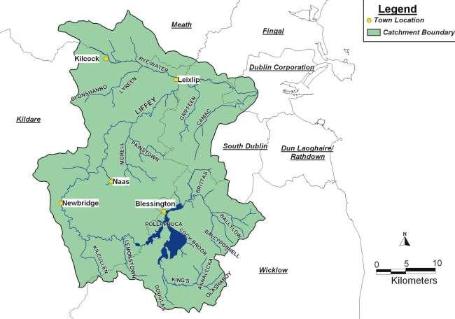
Links to Syllabus. Core Unit 3 Skills Geographical Investigation Core Unit Fluvial processes 1.6 Fluvial adjustment
 River Study Links to Syllabus Core Unit 3 Skills Geographical Investigation Core Unit 2 1.5 Fluvial processes 1.6 Fluvial adjustment Mapping Photographs Sketching Statistical analysis Data collection Report
Landscapes and People of the UK 4 days
 GCSE Geography OCR B Landscapes and People of the UK 4 days Complete all fieldwork requirements, worth 15% of the qualification. In-depth coverage of fieldwork in two contrasting locations enabling students
Figure 1. Which part of the river is labelled in Figure 1? a) Mouth b) Source c) Lower course d) channel
 Mouth b) Source c) Lower course d) channel") Rivers 1. Study Figure 1 showing the long profile of a river Figure 1 A Which part of the river is labelled in Figure 1? a) Mouth b) Source c) Lower course d) channel (1 mark) 2. Complete the sentences
Rivers 1. Study Figure 1 showing the long profile of a river Figure 1 A Which part of the river is labelled in Figure 1? a) Mouth b) Source c) Lower course d) channel (1 mark) 2. Complete the sentences
True or False: The Earth s surface has stayed the same for thousands of years
 True or False: The Earth s surface has stayed the same for thousands of years True or False: The Earth s surface has stayed the same for thousands of years The Earth s surface is always changing! Weathering
Earth and Space: Topographic Maps Satellite Images
 Earth and Space: Topographic Maps Satellite Images Earth and Space: Formative Assessment Activities for Earth and Space Topographic Maps Satellite Images Teacher Pages Purpose The purpose of this station
Module/Unit: Landforms Grade Level: Fifth
 Module/Unit: Landforms Grade Level: Fifth PA Academic Standards for Science and Technology and Environment and Ecology: 3.1.7.B Describe the use of models as an application or scientific or technological
What is weathering and how does it change Earth s surface? Answer the question using
 7 th Grade Lesson What is weathering and how does it change Earth s surface? Answer the question using the sentence frame. You have 4 minutes. Weathering is. This changes the Earth s surface because. 1
10/27/2014. Surface Processes. Surface Processes. Surface Processes. Surface Processes. Surface Processes
 Hewitt/Lyons/Suchocki/Yeh Conceptual Integrated Science Chapter 25 Surface or surficial processes originate at Earth's surface and reshape its contours. Surface processes include: Weathering Erosion Deposition
River Processes. Learning Objective: Discover how a river erodes, transports and deposits material
 River Processes Learning Objective: Discover how a river erodes, transports and deposits material Learning Outcomes: Compare vertical and lateral erosion Describe how a river erodes, transports and deposits
No. of Periods. Syllabus Topics Specific Objectives Teaching Strategies. rational to live in hazard-prone areas?
 (Syllabus for F.4 Geog. September 2016 - July 2017) -1- SING YIN SECONDARY SCHOOL SYLLABUS FOR GEOGRAPHY -- SEPTEMBER 2016 - JULY 2017 FORM FOUR Textbooks : Senior Secondary Exploring Geography 1 (Second
EXTERNAL LAND FORMING PROCESSES
 NAME SCHOOL INDEX NUMBER DATE EXTERNAL LAND FORMING PROCESSES WEATHERING 1 1998 Q 7 (a) (i) What is the difference between weathering and mass wasting (ii) List five processes involved in chemical weathering
STREAM SYSTEMS and FLOODS
 STREAM SYSTEMS and FLOODS The Hydrologic Cycle Precipitation Evaporation Infiltration Runoff Transpiration Earth s Water and the Hydrologic Cycle The Hydrologic Cycle The Hydrologic Cycle Oceans not filling
Precipitation Evaporation Infiltration Earth s Water and the Hydrologic Cycle. Runoff Transpiration
 STREAM SYSTEMS and FLOODS The Hydrologic Cycle Precipitation Evaporation Infiltration Earth s Water and the Hydrologic Cycle Runoff Transpiration The Hydrologic Cycle The Hydrologic Cycle Oceans not filling
Science EOG Review: Landforms
 Mathematician Science EOG Review: Landforms Vocabulary Definition Term canyon deep, large, V- shaped valley formed by a river over millions of years of erosion; sometimes called gorges (example: Linville
Earth Science Chapter 6 Section 2 Review
 Name: Class: Date: Earth Science Chapter 6 Section Review Multiple Choice Identify the choice that best completes the statement or answers the question. 1. Most streams carry the largest part of their
Running Water and the Development of Landforms
 Geography IGCSE Module One: River Environments Lesson Thirteen Running Water and the Development of Landforms Aims The aim of this lesson is for you to learn about: processes including o weathering and
Geography Exams. RAG rate The Challenge of Natural Hazards
 Geography Exams You will sit three papers, Paper 1 will last 1 hour 30 minutes and will examine your understanding of The Challenge of Natural Hazards, The Living World and Physical Landscapes in the UK.
EROSION AND DEPOSITION
 CHAPTER 8 EROSION AND DEPOSITION SECTION 8 1 Changing Earth s Surface (pages 252-255) This section explains how sediment is carried away and deposited elsewhere to wear down and build up Earth s surface.
Unit 2: The Natural Environment
 Write your name here Surname Other names Pearson Edexcel GCSE Centre Number Geography A Unit 2: The Natural Environment Wednesday 8 June 2016 Afternoon Time: 1 hour 15 minutes You do not need any other
Please complete the SoW proforma below for all subjects and courses for publication on the Website this summer.
 2014-2015 Curriculum plan proforma for The Causeway School website Subject Geography Year 9 Please complete the SoW proforma below for all subjects and courses for publication on the Website this summer.
Weathering Erosion and Deposition. Presented by Kesler Science
 Weathering Erosion and Deposition Presented by Kesler Science Essential Questions: 1. What effects do weathering, erosion, and deposition have on the environment in ecoregions? Weathering Chemical and
B The River Nile in Egypt
 3 Rivers Rivers B The River Nile in Egypt The Niagara Falls in North merica D The River Yangtse in China C The Kariba dam in Zimbabwe Rivers are important to people because they provide water, are used
Grade 5 Hands on Science Weathering, Erosion and Deposition
 Grade 5 Hands on Science Weathering, Erosion and Deposition Objective: To demonstrate and investigate the effect of weathering, water and wind erosion and the subsequent deposition into landforms. Background:
Rivers T. Perron
 1 Rivers T. Perron 12.001 After our discussions of large-scale topography, how we represent topography in maps, and how topography interacts with geologic structures, you should be frothing at the mouth
Landscape Development
 Landscape Development Slopes Dominate Natural Landscapes Created by the interplay of tectonic and igneous activity and gradation Deformation and uplift Volcanic activity Agents of gradation Mass wasting
Lecture Outlines PowerPoint. Chapter 5 Earth Science 11e Tarbuck/Lutgens
 Lecture Outlines PowerPoint Chapter 5 Earth Science 11e Tarbuck/Lutgens 2006 Pearson Prentice Hall This work is protected by United States copyright laws and is provided solely for the use of instructors
Changes to Land 5.7B. landforms: features on the surface of Earth such as mountains, hills, dunes, oceans and rivers
 All the landforms on Earth have changed over time and continue to change. Many of the changes were caused by wind, moving water, and moving ice. Mountains have grown and shrunk. Rivers have cut away land
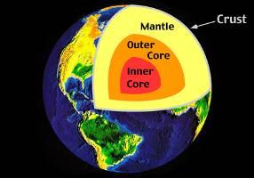
core mantle crust the center of the Earth the middle layer of the Earth made up of molten (melted) rock
 rock") core the center of the Earth mantle the middle layer of the Earth made up of molten (melted) rock crust the surface layer of the Earth that includes the continents and oceans 1 continental drift the theory
core the center of the Earth mantle the middle layer of the Earth made up of molten (melted) rock crust the surface layer of the Earth that includes the continents and oceans 1 continental drift the theory
What do you need for a Marathon?
 What do you need for a Marathon? Water and a snack? What about just a normal day? 1 flush = 3.5 gallons 1 flush = 3.5 gallons 10 minute shower = 20 gal 1 flush = 3.5 gallons 10 minute shower = 20 gal Jeans
Example Task Question : The channel characteristics of a river change along its course.
 Example Task Question : The channel characteristics of a river change along its course. Purpose Focus on velocity Sub focus questions: 1. To what extent is there a regular /even change in velocity downstream?
Think about the landforms where you live. How do you think they have changed over time? How do you think they will change in the future?
 reflect All the landforms on Earth have changed over time and continue to change. Many of the changes were caused by wind, moving water, and moving ice. Mountains have grown and shrunk. Rivers have cut
Coastal Landscapes Case Study 3 days
 GCSE Geography OCR B Coastal Landscapes Case Study 3 days In-depth study of a coastal landscape providing a detailed case study, to ensure students are prepared for Paper 1: Our Natural World. Complete
Streams. Water. Hydrologic Cycle. Geol 104: Streams
 Streams Why study streams? Running water is the most important geologic agent in erosion, transportation and deposition of sediments. Water The unique physical and chemical properties of water make it
Water Erosion (pages )
") Water Erosion (pages 272 281) Runoff and Erosion (pages 273 274) Key Concept: Moving water is the major agent of the erosion that has shaped Earth s land surface. Falling raindrops can loosen and pick
Water Erosion (pages 272 281) Runoff and Erosion (pages 273 274) Key Concept: Moving water is the major agent of the erosion that has shaped Earth s land surface. Falling raindrops can loosen and pick
Which map shows the stream drainage pattern that most likely formed on the surface of this volcano? A) B)
 B)") 1. When snow cover on the land melts, the water will most likely become surface runoff if the land surface is A) frozen B) porous C) grass covered D) unconsolidated gravel Base your answers to questions
1. When snow cover on the land melts, the water will most likely become surface runoff if the land surface is A) frozen B) porous C) grass covered D) unconsolidated gravel Base your answers to questions
LOOK OUT BELOW! (1 Hour)
") LOOK OUT BELOW! (1 Hour) Addresses NGSS Level of Difficulty: 2 Grade Range: K-2 OVERVIEW In this activity, students will create a model of a sloped hillside using sand, and then they will simulate conditions
LOOK OUT BELOW! (1 Hour) Addresses NGSS Level of Difficulty: 2 Grade Range: K-2 OVERVIEW In this activity, students will create a model of a sloped hillside using sand, and then they will simulate conditions
PiXL Independence: Geography Answer Booklet KS4. AQA Style, UK Physical Landscapes. Contents: Answers
 PiXL Independence: Geography Answer Booklet KS4 AQA Style, UK Physical Landscapes Contents: Answers 1 I. Multiple Choice Questions 1 Where in the UK would you describe as having large areas of uplands?
GEOG 1010A. Come to the PASS workshop with your mock exam complete. During the workshop you can work with other students to review your work.
 It is most beneficial to you to write this mock midterm UNDER EXAM CONDITIONS. This means: Complete the midterm in 1.5 hours. Work on your own. Keep your notes and textbook closed. Attempt every question.
NATURAL RIVER. Karima Attia Nile Research Institute
 NATURAL RIVER CHARACTERISTICS Karima Attia Nile Research Institute NATURAL RIVER DEFINITION NATURAL RIVER DEFINITION Is natural stream of water that flows in channels with ih more or less defined banks.
Topic 6: Weathering, Erosion and Erosional-Deposition Systems (workbook p ) Workbook Chapter 4, 5 WEATHERING
 Workbook Chapter 4, 5 WEATHERING") Topic 6: Weathering, Erosion and Erosional-Deposition Systems (workbook p. 95-125) Workbook Chapter 4, 5 THE BIG PICTURE: Weathering, erosion and deposition are processes that cause changes to rock material
Topic 6: Weathering, Erosion and Erosional-Deposition Systems (workbook p. 95-125) Workbook Chapter 4, 5 THE BIG PICTURE: Weathering, erosion and deposition are processes that cause changes to rock material
Bell Ringer. Are soil and dirt the same material? In your explanation be sure to talk about plants.
 Bell Ringer Are soil and dirt the same material? In your explanation be sure to talk about plants. 5.3 Mass Movements Triggers of Mass Movements The transfer of rock and soil downslope due to gravity is
HW #2 Landscape Travel from A to B 12,
 HW #2 Landscape 2016 Section: Name: ate: 1. ase your answer(s) to the following question(s) on the map below, which represents two bridges that cross the Green River. Letters,, and represent locations
Chapter 3 Erosion and Deposition. The Big Question:
 Chapter 3 Erosion and Deposition The Big Question: 1 Design a way to represent and describe the 4 types of mass movement. You may use pictures, diagrams, list, web, chart, etc 2 Chapter 3: Erosion and
mountain rivers fixed channel boundaries (bedrock banks and bed) high transport capacity low storage input output
 high transport capacity low storage input output") mountain rivers fixed channel boundaries (bedrock banks and bed) high transport capacity low storage input output strong interaction between streams & hillslopes Sediment Budgets for Mountain Rivers Little
mountain rivers fixed channel boundaries (bedrock banks and bed) high transport capacity low storage input output strong interaction between streams & hillslopes Sediment Budgets for Mountain Rivers Little
WJEC Eduqas GCSE (9-1) GEOGRAPHY B
 GEOGRAPHY B") WJEC Eduqas GCSE (9-1) GEOGRAPHY B Additional sample questions for Theme 2 Candidate name.. Question Mark (a) (i) /2 (a) (ii) /4 (a) (iii) /4 (a) (iv) /3 (b) (i) /4 (b) (ii) /6 (c) (i) /2 (c) (ii) /1 (c)
WJEC Eduqas GCSE (9-1) GEOGRAPHY B Additional sample questions for Theme 2 Candidate name.. Question Mark (a) (i) /2 (a) (ii) /4 (a) (iii) /4 (a) (iv) /3 (b) (i) /4 (b) (ii) /6 (c) (i) /2 (c) (ii) /1 (c)
2008 JC2 H2 GEOGRAPHY: PIONEER JUNIOR COLLEGE PRELIMINARY EXAMS. Figure 1 for Question 1
 PHYSICAL GEOGRAPHY Figure 1 for Question 1 Figure 2 for Question 2 Tropical air mass source regions Figure 3 for Question 3 Figure 4 for Question 4 Volcanic gases Figure 5 for Question 5 EITHER Photograph
High-Gradient Streams
 Chapter 4 Surface Processes Section 4 High-Gradient Streams What Do You See? Learning Outcomes In this section, you will Use models and real-time streamflow data to understand the characteristics of highgradient
Introduction The Exam...vii. 1. Maps and Photographs...1
 CONTENTS Introduction The Exam...vii Section 1...vii Section 2...viii 1. Maps and Photographs...1 Grid references on maps...1 Scale and measuring distance...3 Directions on maps...5 Area on maps...6 Height
Coastal Landscapes Case Study 3 days
 GCSE Geography OCR A Coastal Landscapes Case Study 3 days In-depth study of a coastal landscape providing a detailed case study, to ensure students are prepared for the Paper 1 exam: Living in the UK Today.
UNIT 3 GEOLOGY VOCABULARY FLASHCARDS THESE KEY VOCABULARY WORDS AND PHRASES APPEAR ON THE UNIT 3 CBA
 UNIT 3 GEOLOGY VOCABULARY FLASHCARDS THESE KEY VOCABULARY WORDS AND PHRASES APPEAR ON THE UNIT 3 CBA A map that shows Earth s Topographic Map surface topography, which is Earth s shape and features Contour
Ch 10 Deposition Practice Questions
 1. Base your answer to the following question on the data table below. Six identical cylinders, A through F, were filled with equal volumes of sorted spherical particles. The data table shows the particle
Erosion and Deposition
 Erosion and Deposition Erosion Sediment natural forces move rock/soil from one place to another. gravity, water, wind, glaciers, waves are causes material moved by erosion Deposition when erosion lays
Marr College Geography Department. Can-Do Checklist for Higher Geography
 Marr College Geography Department Can-Do Checklist for Higher Geography The Higher Geography exam consists of one paper. It is out of a total of 60 marks. The total time for the paper is 2 hours 15 minutes.
2018 Geography Mock Examination
 2018 Geography Mock Examination Your Geography mock examination will test your understanding of Paper 1 (Living with the physical environment) and Section B (Fieldwork) from Paper 2. Attached are the necessary
ES 105 Surface Processes I. Hydrologic cycle A. Distribution % in oceans 2. >3% surface water a. +99% surface water in glaciers b.
 ES 105 Surface Processes I. Hydrologic cycle A. Distribution 1. +97% in oceans 2. >3% surface water a. +99% surface water in glaciers b. >1/3% liquid, fresh water in streams and lakes~1/10,000 of water
Flooding and it s solutions
 Flooding and it s solutions Describe this hydrograph in 35 words What is a flood? What is a flood? A period of of high discharge, where the river overflows its banks Why is this a problem? What are some
1. Erosion by Running Water Most powerful cause of erosion
 I. Destructive Forces Notes: Destructive force: a process in which land is destroyed or changed such as weathering and erosion. All landforms are a result of a combination of constructive and destructive
Laboratory Exercise #3 The Hydrologic Cycle and Running Water Processes
 Laboratory Exercise #3 The Hydrologic Cycle and Running Water Processes page - 1 Section A - The Hydrologic Cycle Figure 1 illustrates the hydrologic cycle which quantifies how water is cycled throughout
Teaching Resource for KS2 Investigating Rivers
 Teaching Resource for KS2 Investigating Rivers The Parrett Catchment Project Edited by Sam Woodhouse Page 2 Scheme of Work Investigating Rivers An adaptation of the KS2 unit on rivers and water About this
3 Erosion and Deposition by Ice
 CHAPTER 12 3 Erosion and Deposition by Ice SECTION Agents of Erosion and Deposition BEFORE YOU READ After you read this section, you should be able to answer these questions: What are glaciers? How do
water erosion lithosphere Describe the process of erosion and deposition. chemical weathering Dissolving limestone is an example of.
 At one time, there was one large island off the coast of Mississippi and now it is two separate islands. What caused the island to be split into two? water erosion The crust and the top part of the upper
NCM COMPUTER & BUSINESS ACADEMY ASSIGNMENT TERM
 NCM COMPUTER & BUSINESS ACADEMY SUBJECT: GEOGRAPHY GRADE 12 ASSIGNMENT TERM 1-2016 TOTAL: 150 MARKS LECTURER: ANSWER ALL QUESTIONS CLIMATE, WEATHER AND GEOMORPHOLOGY Answer at least ONE question in this
Chapter 2. Wearing Down Landforms: Rivers and Ice. Physical Weathering
 Chapter 2 Wearing Down Landforms: Rivers and Ice Physical Weathering Weathering vs. Erosion Weathering is the breakdown of rock and minerals. Erosion is a two fold process that starts with 1) breakdown
EARTH S CHANGING SURFACE
 EARTH S CHANGING SURFACE Weathering Together, weathering and erosion work continuously to wear down the material on Earth s surface. weathering process that breaks down rock and other substances of Earth
Chapter 2. Denudation: Rivers and Ice
 Chapter 2. Denudation: Rivers and Ice DENUDATION: process that lowers level of land - caused by rivers, glaciers, waves & wind - involves processes of WEATHERING & EROSION Weathering Def: breakdown of
Weathering, Erosion, Deposition, and Landscape Development
 Weathering, Erosion, Deposition, and Landscape Development I. Weathering - the breakdown of rocks into smaller particles, also called sediments, by natural processes. Weathering is further divided into
SESSION 9: CLIMATE AND WEATHER, FLUVIAL PROCESSES AND MAPWORK
 SESSION 9: CLIMATE AND WEATHER, FLUVIAL PROCESSES AND MAPWORK KEY CONCEPTS: In this session we will: Integrate theory and mapwork. Look specifically at how climate and weather and fluvial processes can
Geography Curriculum Overview
 Geography Curriculum Overview 2016-2017 Suggest one topic a year for each year group based on another city/country or possible local. Suggested ideas for some year groups have been put in as they will
27. Running Water I (p ; )
") 27. Running Water I (p. 424-436; 440-444) Hydrosphere How much of the Earth s surface is covered by water? Earth's water is collectively called the and is stored in a number of so-called as follows: 1.
27. Running Water I (p. 424-436; 440-444) Hydrosphere How much of the Earth s surface is covered by water? Earth's water is collectively called the and is stored in a number of so-called as follows: 1.
1. Any process that causes rock to crack or break into pieces is called physical weathering. Initial product = final product
 Weathering 1. Any process that causes rock to crack or break into pieces is called physical weathering. Initial product = final product End Result of physical weathering is increased surface area. 2. Physical
6.1 Water. The Water Cycle
 6.1 Water The Water Cycle Water constantly moves among the oceans, the atmosphere, the solid Earth, and the biosphere. This unending circulation of Earth s water supply is the water cycle. The Water Cycle
Prentice Hall EARTH SCIENCE
 Prentice Hall EARTH SCIENCE Tarbuck Lutgens Running Water and Groundwater Running Water The Water Cycle Water constantly moves among the oceans, the atmosphere, the solid Earth, and the biosphere. This
Lecture 10 Glaciers and glaciation
 Lecture 10 Glaciers and glaciation Outline Importance of ice to people! Basics of glaciers formation, classification, mechanisms of movement Glacial landscapes erosion and deposition by glaciers and the
Final Exam. Running Water Erosion and Deposition. Willamette Discharge. Running Water
 Final Exam Running Water Erosion and Deposition Earth Science Chapter 5 Pages 120-135 Scheduled for 8 AM, March 21, 2006 Bring A scantron form A calculator Your 3 x 5 paper card of formulas Review questions
MASS MOVEMENTS, WIND, AND GLACIERS
 Date Period Name MASS MOVEMENTS, WIND, AND GLACIERS SECTION.1 Mass Movements In your textbook, read about mass movements. Use each of the terms below just once to complete the passage. avalanche creep
MANGU HIGH SCHOOL NAME: ADM NO: CLASS: Kenya Certificate of Secondary Education MOCK EXAMINATIONS. Geography Paper 1 2 ¾ Hours.
 MANGU HIGH SCHOOL 312/1 GEOGRAPHY PAPER 1 JULY 2014 TIME: 2¾ HOURS NAME: ADM NO: CLASS: INSTRUCTIONS TO CANDIDATES Kenya Certificate of Secondary Education MOCK EXAMINATIONS Geography Paper 1 2 ¾ Hours.
Environmental Geology Chapter 9 Rivers and Flooding
 Environmental Geology Chapter 9 Rivers and Flooding Flooding in Pakistan 2010-1600 killed/20000 affected The hydrologic cycle is powered by the Sun The cycle includes evaporation, precipitation, infiltration,
In this activity, students experiment with sand and hair dryers to observe how wind, sand, and barriers interact to form sand dunes.
 SAND SHAKE (1 Hour) Addresses NGSS Level of Difficulty: 2 Grade Range: K-2 OVERVIEW In this activity, students experiment with sand and hair dryers to observe how wind, sand, and barriers interact to form
Environmental Science EES B02H3 PRINCIPLES OF GEOMORPHOLOGY
 THE UNIVERSITY of TORONTO at SCARBOROUGH January, 2009 Department of Physical & Environmental Sciences Environmental Science EES B02H3 PRINCIPLES OF GEOMORPHOLOGY The earth s surface form and its dynamic
Earthquake hazards. Aims 1. To know how hazards are classified 2. To be able to explain how the hazards occur 3. To be able to rank order hazards
 Earthquake hazards Aims 1. To know how hazards are classified 2. To be able to explain how the hazards occur 3. To be able to rank order hazards Types of hazard Primary A direct result of the earthquake
Study Module for RIVER PROCESSES. Geo Lab at Nordland National Park Centre. HANDBOOK for TEACHERS
 Study Module for RIVER PROCESSES Geo Lab at Nordland National Park Centre HANDBOOK for TEACHERS Table of contents 1 Summary of module... 3 1.1 Level... 5 1.2 Objectives... 5 1.3 Curriculum links... 5 1.3.1