Introducing Catastrophe Risk
|
|
|
- Marianna Summers
- 6 years ago
- Views:
Transcription
1 Introducing Catastrophe Risk Ioannis Papanikolaou 1 Marie Dequae 2 Topic Owners of CATRISK subgroup of Strategic areas 1 Laboratory of Mineralogy & Geology, Department of Natural Resources Development and Agricultural Engineering, Agricultural University of Athens, Greece 2 Federation of European Risk management Associations (FERMA) This presentation expresses the views of the author and neither the views of EIOPA nor the IRSG. Insurance and Reinsurance Stakeholder Group meeting 29 April 2014
2 Natural Hazards: Trends, Models and Impact on Insurance Ioannis Papanikolaou Assist. Prof. Laboratory of Mineralogy & Geology, Department of Natural Resources Development and Agricultural Engineering, Agricultural University of Athens, Greece Hons Research Fellow, Department of Earth Sciences, University College London Insurance and Reinsurance Stakeholder Group meeting 29 April 2014

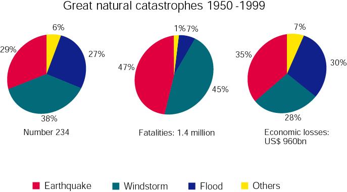
3 Natural Hazards Economic losses 380 bn US$. 2011

4 The number of great natural catastrophes have increased by a factor of 4 since the 1950s Economic losses have been increased by a factor of 14

5 Following the year 2000 there is a ~35% increase in the number of catastrophic events since the 90ies and 2 fold increase since the 80ies
6 Following the year 2000 there is approx. a two fold increase in the cost of catastrophic events since the 90ies and 3 fold increase since the 80ies
7 The main question to ask: Why this dramatically increasing trend exists both in terms of the number and costs of natural hazards? Have the earth processes and mechanisms been modified? Well mostly not, the answer is vulnerability (population growth, population located in vulnerable sites, near coastlines, rivers and close to tectonic plate boundaries, resettlement from rural areas to megacities, modern way of living etc)
8 Estimated damage (US $ billion) EM-DAT Universite Catholique de Louvain 0.35 What are the peaks on the record? Tohoku earthquake and tsunami Kobe earthquake Hurricane Katrina Wenchuan earthquake 1975 Year 2010

9 Total vs Insured losses since 1970 The four peaks with a high impact on the costs Munich Re
10 Munich Re
11 UN warns that economic losses from natural hazards are out of control and urges private sector to reduce risk (UN press release 2013) So far this century, direct losses from disasters are in the range of $2.5 trillion. Losses will continue to escalate unless disaster risk management becomes a core part of business investment strategies. Disaster risk is a new multi-trillion dollar asset class: Global capital flows have transformed the landscape of disaster risk, creating a new pile of toxic assets for businesses and governments that do not currently appear on balance. Globally, US$71 trillion of assets would be exposed to one in 250 year earthquakes. Insurance is critical to business resilience. Yet insurance pricing often does not reflect risk levels. Global Assessment Report on Disaster Risk Reduction United Nations 2013
12 Main components Hazard module Exposure data Catastrophe Models Vulnerability/Risk module Financial module (loss) Final outcome EP Curve An EP curve communicates the probability of any given financial loss being exceeded Currently all models are closed black boxes, without any possibility for validation or evaluation from users.
13 Failure of Existing Catastrophe models Tens of examples mostly regarding geohazards Most spectacular failure examples The two of the three strongest earthquakes followed by the two strongest tsunami events ever recorded during the instrumental period The 2004 Great Sumatra-Andaman Earthquake (Mw)= 9.2 killing over 230,000 people in fourteen countries, The Tohoku 2011 Japan (Mw)= 9.0 (19000 fatalities, buildings totally or partly collapsed, total 1.2 million houses damaged evacuated, 90% of fishing boats unusable. Honda, Toyota, Nissan suspended auto production for several days. Japan reports first trade deficit in 32 years after the tsunami. Total estimated damages ranging from 208 to 574 billions US$, Insured losses ~30 billion US$.


14 With regard to the 2004 Boxing Day tsunami, geoscientific data provided clear evidence for past major tsunami events (e.g. JANKAEW et al. 2008).


15 HOW DO WE TRACE TSUNAMI DEPOSITS? AN EXAMPLE FROM THE TΗΕRMAIKOS GULF Reicherter, Papanikolaou et al. (2010)
16 Following the 2004 Sumatra event did new Cat Risk models incorporate new data and adapt new scenarios? The answer is NO, despite overwhelming evidence from the paleoseismological and geological record Only when the initial shock had passed, the public learned that the region had experienced paleoearthquakes and palaeotsunami events in the past which were similar to the 2011 event, if not even greater (Minoura & Nakaya 1991, Nishimura & Miyaji 1995, Minoura al. 2001, Sawai et al etc), several publications from different researchers
17
18

19 Another example demonstrating the incompleteness of the historical record. Greece has one of the longest seismic historical catalogues worldwide with dating events since 550BC. However, National Seismic Building Code (EAK-1984) Kozani-Grevena 1995 M=6.6 in an aseismic region This map is only based on historical seismicity
20 Therefore, the map has been modified, but.. Following the 1995 event, now this area is of higher hazard.. Athens 1999 M=5.9 National Seismic Building Code (EAK-2000)
21 Finally, no aseismic area in Greece National Seismic Building Code (EAK-2003)
")
22 Seismicity of Greece Despite the long catalogue, it is considered complete for events M 7.3 since 1500 and for M 6.5 only since 1845 Papazachos et al. (2000)
23 The record is complete for events M 7.3 for 500 years and for events M 6.5 for less than 200 years. However, active faults have recurrence intervals ranging from a few hundred years to several thousand of years. As a result, historic catalogues are generally too short compared to the recurrence interval of particular faults. The latter implies that the sample from the historical record is clearly incomplete even for Greece and that a large number of faults would not have been ruptured during the completeness period of the historical record. Moreover, maps based on historical seismicity can give erroneous pictures of the present day hazard (Scholz 2002). Events appearing on the record originate from faults that were activated recently with their energy now released, being at an early stage in their new seismic cycle. However, missing events from the record could correspond to faults which are mature, approaching the end of their cycle, so that events are pending in the near future.
24 The role of Geological Data We use geological data in order to extend the history back many thousand of years eliminating the incompleteness of the historical catalogues. In particular, in seismic hazard assessment: a) so as to identify all possible seismic sources (localities of active faults) b) so as to assess which faults slip in earthquakes most often (define slip-rates and earthquake recurrence) c) so as to define the elapsed time since the last event on a given fault Current CatRisk models tend to use mainly the historical record (historical epicenters not faults) and do not keep up with emerging scientific knowledge


25 Offsets caused by earthquakes 1980 Irpinia earthquake ruptures 1981 Corinth earthquake ruptures


26 Cumulative slip, hundreds of earthquakes Faults leave their signatures on the landscape and the geology.
27 Past Major Catastrophic Events in Europe 1650 BC Santorini volcanic eruption and tsunami Vesuvius 79 AD Eruption 365 A.D. M~8.2 Crete-Hellenic Arc Strongest earthquake and tsunami in Europe in historical times 1755 Lisbon earthquake and tsunami (~ fatalities) 1816 Year without a summer (due to volcanic Mount Tambora volcanic eruption in 1815) food shortages famine, hundreds of thousands lost their lives 1908 Messina Mw=7.1, fatalities 1915 Fucino Earthquake Mw=7.0, fatalities Question: Recurrence of these events? Other events not been recorded historically but pending?

28 Vesuvius is located just 10 km from the centre of Naples with 1.2 million inhabitants. Estimated total economic loss US $24 billions Willis Research Network Spence et al. (2010)
29 We have not experienced such a major catastrophic event in Europe over the last few decades yet What would be the impact to consumers confidence if insurance fails to deliver? Particularly if other types of insurance fail as well (life, health etc).
30 Solvency II requires Transparency The Alliance for Global Open Risk Analysis (AGORA) makes an effort to create and disseminate open multi-hazard cat risk modelling tools Florida International University (FIU) in Miami has begun developing a public loss model to assess hurricane risk in Florida. Consumers also need to know and the European Parliament support this idea as well (see 2013/2174) To address the challenges of transparency and credibility of the models, the Bank of Greece as a supervisor is developing a fault specific high spatial resolution seismic catastrophe model in cooperation with universities providing results on expected insured losses for specific properties by ZIP code
31 EIOPA in 2012 introduced some Standard Formula with tables showing the gross loss damage ratio (Qcountry) for 1 in 200 year catastrophe events Aggregate country level exposure data are inadequate to properly reflect the high spatial and temporal variability in natural catastrophe risk Risk factors for some countries are too high, (e.g. Cyprus, Romania), whereas others too low (Italy, France) compared to their hazard module EIOPA-DOC-12/ December 2012
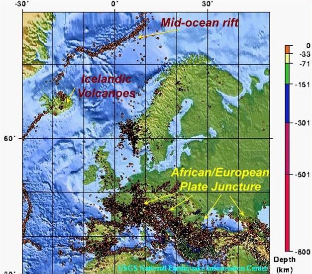
32 USGS


33 Composite Seismogenic Sources Composite Seismogenic Sources from Share Project
34 Impact of CAT RISK on other types of insurance Life insurance Health insurance Economic growth the Athens event was a moderate earthquake however it cost 3% of Greece s GDP (Greece today due to the crisis would be unable to cope), The Japan Tohoku cost 4.5% of the country GDP, Japan reports first trade deficit in 32 years after the tsunami The next Great Kanto Earthquake scenario in Tokyo (similar to the catastrophic 1923 event with fatalities) will cost ~1.1$ trillion, about 20% of Japan s GDP with a high default risk of the Japanese government. Japanese holdings around the world are sold in order to finance the reconstruction after the loss. Globalization of risk?
35 Finally, last but not least Following a catastrophic event there is an extremely large number of claims being filed at the same time. Can catastrophe insurance issuers effectively manage risk? Overall, is Cat Risk the weakest link of insurance that could undermine people s confidence to insurance?
Publishable Summary. Summary Description of the project context and main objectives
 Publishable Summary Summary Description of the project context and main objectives Tsunamis are low frequency but high impact natural disasters. In 2004, the Boxing Day tsunami killed hundreds of thousands
Pacific Catastrophe Risk Assessment And Financing Initiative
 Pacific Catastrophe Risk Assessment And Financing Initiative PALAU September is expected to incur, on average,.7 million USD per year in losses due to earthquakes and tropical cyclones. In the next 5 years,
Pacific Catastrophe Risk Assessment And Financing Initiative
 Pacific Catastrophe Risk Assessment And Financing Initiative TIMOR-LESTE September Timor-Leste is expected to incur, on average, 5.9 million USD per year in losses due to earthquakes and tropical cyclones.
World Meteorological Organization
 World Meteorological Organization Opportunities and Challenges for Development of Weather-based Insurance and Derivatives Markets in Developing Countries By Maryam Golnaraghi, Ph.D. Head of WMO Disaster
Pacific Catastrophe Risk Assessment And Financing Initiative
 Pacific Catastrophe Risk Assessment And Financing Initiative VANUATU September 211 Country Risk Profile: VANUATU is expected to incur, on average, 48 million USD per year in losses due to earthquakes and
Trends of Natural Disasters in the Asia- Pacific Region and the Direction of Disaster Management
 2016 APEC SCCC, Arequipa, Peru Session 6 - Human Security: Food, Health, Natural Disasters and Environmental Issues Trends of Natural Disasters in the Asia- Pacific Region and the Direction of Disaster
Lesson 8. Natural Disasters
 Lesson 8 Natural Disasters 1 Reading is NOT a spectator sport! 2 Reading requires active participation! 3 PREDICT Try to figure out what information will come next and how the selection might end. 4 Natural
Pacific Catastrophe Risk Assessment And Financing Initiative
 Pacific Catastrophe Risk Assessment And Financing Initiative TUVALU is expected to incur, on average,. million USD per year in losses due to earthquakes and tropical cyclones. In the next 5 years, has
The Inevitability and Consequences of Mega-Disasters in a Crowded World
 The Inevitability and Consequences of Mega-Disasters in a Crowded World John J. Clague Centre for Natural Hazard Research Simon Fraser University NOAA Katrina 2005 Outline Hazard, risk, disasters, and
STRESS IN THE SYSTEM? INSIGHTS INTO MODELLING IN THE WAKE OF TOHOKU
 STRESS IN THE SYSTEM? INSIGHTS INTO MODELLING IN THE WAKE OF TOHOKU Aspen Re June 13, 2012 James Few President, Aspen Re Aspen Insurance Holdings Limited AGENDA Do we need near-term quake rates? Lessons
Initiative. Country Risk Profile: papua new guinea. Better Risk Information for Smarter Investments PAPUA NEW GUINEA.
 Pacific Catastrophe Risk Assessment And Financing Initiative PAPUA NEW GUINEA September 211 Country Risk Profile: papua new is expected to incur, on average, 85 million USD per year in losses due to earthquakes
Session III: Geohazards - Minimizing Risk, Maximizing Awareness. Grand Challenges on Natural and Human-induced Hazards and Disasters
 Session III: Geohazards - Minimizing Risk, Maximizing Awareness Grand Challenges on Natural and Human-induced Hazards and Disasters Sospeter Muhongo s.muhongo@icsu-africa.org www.icsu-africa.org IYPE-Global
KNOWLEDGE NOTE 5-1. Risk Assessment and Hazard Mapping. CLUSTER 5: Hazard and Risk Information and Decision Making. Public Disclosure Authorized
 Public Disclosure Authorized Public Disclosure Authorized Public Disclosure Authorized Public Disclosure Authorized KNOWLEDGE NOTE 5-1 CLUSTER 5: Hazard and Risk Information and Decision Making Risk Assessment
Earthquake Hazards. Tsunami
 Earthquake Hazards Tsunami Review: What is an earthquake? Earthquake is the vibration (shaking) and/or displacement of the ground produced by the sudden release of energy. The point inside the Earth where
2018 REVIEW OF DISASTER EVENTS
 2018 REVIEW OF DISASTER EVENTS Supplementary Information* BRUSSELS, 24 January, 2019 In 2018, there were 281 climate-related and geophysical events recorded in the EM-DAT (International Disaster Database)
Earthquake Hazards. Tsunami
 Earthquake Hazards Tsunami Measuring Earthquakes Two measurements that describe the power or strength of an earthquake are: Intensity a measure of the degree of earthquake shaking at a given locale based
AIR Earthquake Model for the PanEuropean Region
 AIR Earthquake Model for the PanEuropean Region The powerful earthquakes that struck Turkey in 1999 and Italy s Abruzzo region in 2009 caused extensive damage. And recent studies suggest that a quake near
UGRC 144 Science and Technology in Our Lives/Geohazards
 UGRC 144 Science and Technology in Our Lives/Geohazards Session 1 Introduction to Hazards and Disasters Dr. Patrick Asamoah Sakyi Department of Earth Science, UG, Legon College of Education School of Continuing
Lessons from the 2004 Sumatra earthquake and the Asian tsunami
 Lessons from the 2004 Sumatra earthquake and the Asian tsunami Kenji Satake National Institute of Advanced Industrial Science and Technology Outline 1. The largest earthquake in the last 40 years 2. Tsunami
AIRCURRENTS THE TOHOKU EARTHQUAKE AND STRESS TRANSFER STRESS TRANSFER
 THE TOHOKU EARTHQUAKE AND STRESS TRANSFER AIRCURRENTS 11.2011 Edited Editor s Note: The March 11th Tohoku Earthquake was unprecedented in Japan s recorded history. In April, AIR Currents described the
Earthquake Hazards. Tsunami
 Earthquake Hazards Tsunami Review: What is an earthquake? Earthquake is the vibration (shaking) and/or displacement of the ground produced by the sudden release of energy. The point inside the Earth where
Students will be able, using GIS, to locate the largest and most destructive earthquakes;
 Exploring Earthquake Hazards with GIS Laboratory for Introduction to Geophysics, Spring 2007 Prof. Constantin Cranganu Brooklyn College of the City University of New York Learning Objectives: Students
Hazard and Vulnerability of Moderate Seismicity Regions
 Hazard and Vulnerability of Moderate Seismicity Regions presented by Professor Tso-Chien PAN Dean, College of Engineering Director, 25 October 2010 DRM GDLN Session on Earthquake Vulnerability Reduction
RECENT DEVELOPMENTS IN THE TSUNAMI RESEARCH IN GREECE: A SHORT REVIEW GERASSIMOS A. PAPADOPOULOS
 CHAPTER 7 RECENT DEVELOPMENTS IN THE TSUNAMI RESEARCH IN GREECE: A SHORT REVIEW GERASSIMOS A. PAPADOPOULOS Institute of Geodynamics, National Observatory of Athens, 11810 Athens, Greece In: S. L. SOLOVIEV,
Earthquakes down under: a rare but real hazard
 University of Wollongong Research Online Faculty of Science, Medicine and Health - Papers Faculty of Science, Medicine and Health 2015 Earthquakes down under: a rare but real hazard Solomon Buckman University
SEISMIC RISK ASSESSMENT IN ARMENIA
 SEISMIC RISK ASSESSMENT IN ARMENIA Hovhannes Khangeldyan Head of National Crisis Management Center Rescue Service Ministry of Emergency Situations of the Republic of Armenia Tokyo, 2016 ARMENIA: GEOGRAPHICAL
Forecasting Future Earthquakes from Tsunami Deposits and Simulation
 Forecasting Future Earthquakes from Tsunami Deposits and Simulation Kenji Satake Earthquake Research Institute The University of Tokyo satake@eri.u-tokyo.ac.jp Contents 1. Earthquake Recurrence and Forecast
The Science and Policy of Natural Hazards
 Image courtesy of USGS. 12.103 Image courtesy of NOAA. The Science and Policy of Natural Hazards Image courtesy of USGS. Image courtesy of NOAA. Topics Four categories of hazards will be investigated in
They include earthquakes, volcanic eruptions, floods, landslides, and other processes and occurrences. They are included in the broader concept of.
 They include earthquakes, volcanic eruptions, floods, landslides, and other processes and occurrences. They are included in the broader concept of. In general, natural processes are labeled hazardous only
Usually, only a couple of centuries of earthquake data is available, much shorter than the complete seismic cycle for most plate motions.
 Earthquake Hazard Analysis estimate the hazard presented by earthquakes in a given region Hazard analysis is related to long term prediction and provides a basis to expressed hazard in probabilistic terms.
Tsunami and earthquake in Chile Part 2
 EUROPEAN COMMISSION DIRECTORATE GENERAL JRC JOINT RESEARCH CENTRE Institute for the Protection and Security of the Citizen Global Security and Crisis Management Unit CriTech Sunday, 28 February 2010 Executive
Dr. ELIAS A., International Day for Disaster Risk Reduction, AUB - 15 Oct 2012
 3/3/14 Dr. Ata ELIAS, Geology department AUB Outline 1. Tsunami events: 2. The physical and geological tsunami event 3. Global tsunami mitigation efforts Tsunami hazard 1. The tsunami hazard in the Mediterranean
New Multi-Hazard and Multi-Risk. (MATRIX) project
 project") New Multi-Hazard and Multi-Risk Assessment Methods for Europe (MATRIX) project Kevin Fleming Earthquake Risk and Early Warning Helmholtz Centre Potsdam GeoForschungsZentrum Multi-type interactions (1)
New Multi-Hazard and Multi-Risk Assessment Methods for Europe (MATRIX) project Kevin Fleming Earthquake Risk and Early Warning Helmholtz Centre Potsdam GeoForschungsZentrum Multi-type interactions (1)
Earthquake Source. Kazuki Koketsu. Special Session: Great East Japan (Tohoku) Earthquake. Earthquake Research Institute, University of Tokyo
 Earthquake. Earthquake Research Institute, University of Tokyo") 2012/9/24 17:20-17:35 WCEE SS24.4 Special Session: Great East Japan (Tohoku) Earthquake Earthquake Source Kazuki Koketsu Earthquake Research Institute, University of Tokyo 1 Names and features of the earthquake
2012/9/24 17:20-17:35 WCEE SS24.4 Special Session: Great East Japan (Tohoku) Earthquake Earthquake Source Kazuki Koketsu Earthquake Research Institute, University of Tokyo 1 Names and features of the earthquake
M 7.1 EARTHQUAKE 5KM ENE OF RABOSO, MEXICO EXACT LOCATION: N W DEPTH: 51.0KM SEPTEMBER 19, 1:14 LOCAL TIME
 M 7.1 EARTHQUAKE 5KM ENE OF RABOSO, MEXICO EXACT LOCATION: 18.584 N 98.399 W DEPTH: 51.0KM SEPTEMBER 19, 2017 @ 1:14 LOCAL TIME Photo: Eduardo Verdugo / AP Photo: Alfredo Estrella/ Agence France-Presse/
M-8.1 EARTHQUAKE 87KM SW OF PIJIJIAPAN, MEXICO EXACT LOCATION: N W DEPTH: 69.7KM SEPTEMBER 7, 11:49 PST
 M-8.1 EARTHQUAKE 87KM SW OF PIJIJIAPAN, MEXICO EXACT LOCATION: 15.068 N 93.715 W DEPTH: 69.7KM SEPTEMBER 7, 2017 @ 11:49 PST Photo: Luis Alberto Cruz / AP Photo: Carlos Jasso 1 THE 2017 CHIAPAS MEXICO
The Cascading Hazards from Cascadia s Earthquakes
 Tsunamis The Cascading Hazards from Cascadia s Earthquakes Earthquakes (Nisqually earthquake, Seattle, WA) Volcanoes (Mt St Helens eruption, WA) Joan Gomberg gomberg@usgs.gov Landslides (Oso landslide,
GEO-VIII November Geohazard Supersites and Natural Laboratories Progress Report. Document 9
 GEO-VIII 16-17 November 2011 Geohazard Supersites and Natural Laboratories Progress Report Document 9 This document is submitted to GEO-VIII for information. Geohazard Supersites and Natural Laboratories
Application of a GIS for Earthquake Hazard Assessment and Risk Mitigation in Vietnam
 Application of a GIS for Earthquake Hazard Assessment and Risk Mitigation in Vietnam Nguyen Hong Phuong Earthquake Information and Tsunami Warning Centre, VAST OUTLINE Introduction Fault Source Model and
Characteristics and introduction of Earthquake in Asia-Pacific region
 Characteristics and introduction of Earthquake in Asia-Pacific region 1906 San Francisco 2011 Tohoku 1999 Chi-Chi 1985 Mexico City 2004 Sumatra Chung-Han Chan 詹忠翰 2011 Christchurch To understand the characteristics
Students will be able, using GIS, to locate the largest and most destructive earthquakes;
 Exploring Earthquake Hazards with GIS Laboratory for Introduction to Geophysics, Spring 2007 Prof. Constantin Cranganu Brooklyn College of the City University of New York Learning Objectives: Students
Earthquakes and Tsunamis
 Earthquakes and Tsunamis Kenji Satake Earthquake Research Institute University of Tokyo 1 Part I 2011 Tohoku earthquake and tsunami 2 Fukushima Dai ichi NPP accident Earthquake ground motion Reactors automatically
GEOL/GEOE 344: EARTHQUAKES AND SEISMIC HAZARDS (FALL 2001) FINAL EXAM NAME: TIME AVAILABLE: 120 MINUTES TOTAL POINTS: 110
 FINAL EXAM NAME: TIME AVAILABLE: 120 MINUTES TOTAL POINTS: 110") GEOL/GEOE 344: EARTHQUAKES AND SEISMIC HAZARDS (FALL 2001) FINAL EXAM NAME: TIME AVAILABLE: 120 MINUTES TOTAL POINTS: 110 (yep, that s 10 bonus points, just for showing up!) Instructions: There are several
GEOL/GEOE 344: EARTHQUAKES AND SEISMIC HAZARDS (FALL 2001) FINAL EXAM NAME: TIME AVAILABLE: 120 MINUTES TOTAL POINTS: 110 (yep, that s 10 bonus points, just for showing up!) Instructions: There are several
EARTHQUAKE HAZARD ASSESSMENT IN KAZAKHSTAN
 EARTHQUAKE HAZARD ASSESSMENT IN KAZAKHSTAN Dr Ilaria Mosca 1 and Dr Natalya Silacheva 2 1 British Geological Survey, Edinburgh (UK) imosca@nerc.ac.uk 2 Institute of Seismology, Almaty (Kazakhstan) silacheva_nat@mail.ru
Source:
 Source: http://www.pastforward.ca/perspectives/columns/10_02_05.htm At 16:53, on Wednesday, January 12th, 2010, a devastating 7.0 earthquake struck Haiti's capital, Port-au-Prince. The earthquake left
Disaster Risk Management in India. Kamal Kishore New Delhi, 27 October 2016
 Disaster Risk Management in India Kamal Kishore New Delhi, 27 October 2016 Hazard, Exposure and Vulnerability Disaster Prevention Mitigation Hurricane Matthew: Cuba & Haiti Emergency Response Coordination
EXECUTIVE SUMMARY. The title of this dissertation is Quantitative Study on Natural Disasters Risk
 1 EXECUTIVE SUMMARY The title of this dissertation is Quantitative Study on Natural Disasters Risk Management Policy Applying Statistical Data Analysis and Mathematical Modeling Approach. This research
Vulnerability of Bangladesh to Cyclones in a Changing Climate
 Vulnerability of Bangladesh to Cyclones in a Changing Climate Susmita Dasgupta Kiran Pandey Mainul Huq Zahirul Huq Khan M.M. Zahid Ahmed Nandan Mukherjee Malik Fida Khan 2010 Bangladesh: Tropical Cyclone
Earthquakes. Earthquake Magnitudes 10/1/2013. Environmental Geology Chapter 8 Earthquakes and Related Phenomena
 Environmental Geology Chapter 8 Earthquakes and Related Phenomena Fall 2013 Northridge 1994 Kobe 1995 Mexico City 1985 China 2008 Earthquakes Earthquake Magnitudes Earthquake Magnitudes Richter Magnitude
Disaster Risk Assessment: Opportunities for GIS and data management with Open DRI
 Disaster Risk Assessment: Opportunities for GIS and data management with Open DRI Jacob Opadeyi Department of Geomatics Engineering and Land Management, The University of the West Indies, St. Augustine,
STUDY ON TSUNAMIGENIC EARTHQUAKE CRITERIA FOR THE INDONESIAN TSUNAMI EARLY WARNING SYSTEM
 STUDY ON TSUNAMIGENIC EARTHQUAKE CRITERIA FOR THE INDONESIAN TSUNAMI EARLY WARNING SYSTEM Nanang T. Puspito 1 1 Geophysics Research Group, Faculty of Mining and Petroleum Engineering, Institute of Technology
CURRENT AND FUTURE TROPICAL CYCLONE RISK IN THE SOUTH PACIFIC
 CURRENT AND FUTURE TROPICAL CYCLONE RISK IN THE SOUTH PACIFIC COUNTRY RISK PROFILE: SAMOA JUNE 2013 Samoa has been affected by devastating cyclones on multiple occasions, e.g. tropical cyclones Ofa and
Regional Wind Vulnerability. Extratropical Cyclones Differ from Tropical Cyclones in Ways That Matter
 Regional Wind Vulnerability in Europe AIRCurrents 04.2011 Edited Editor s note: European winter storms cause significant damage. Their expected annual insured losses far surpass those of any other peril
New Tsunami Disaster Mitigation System considering Local Conditions of Indian Ocean Rim Regions
 New Tsunami Disaster Mitigation System considering Local Conditions of Indian Ocean Rim Regions Kimiro Meguro Professor, Institute of Industrial Science, The University of Tokyo, Japan Shunichi Koshimura
Coping With Disaster: The Impact of Hurricanes on International Financial Flows,
 Coping With Disaster: The Impact of Hurricanes on International Financial Flows, 1970-2001 Dean Yang Gerald R. Ford School of Public Policy University of Michigan 1 Motivation Disasters cause huge human
The U.S. Geological Survey (USGS) National Earthquake Information Center (NEIC)
 National Earthquake Information Center (NEIC)") The U.S. Geological Survey (USGS) National Earthquake Information Center (NEIC) Gavin Hayes U.S. Geological Survey, National Earthquake Information Center NEIC Mission NEIC - The People 24x7 Operations
The U.S. Geological Survey (USGS) National Earthquake Information Center (NEIC) Gavin Hayes U.S. Geological Survey, National Earthquake Information Center NEIC Mission NEIC - The People 24x7 Operations
EARTH OBSERVATION SERVICES IN REPUBLIC OF MOLDOVA
 EARTH OBSERVATION SERVICES IN REPUBLIC OF MOLDOVA Vasile ALCAZ 1 Ion APOSTOL 2 1 Institute of Geology and Seismology Moldavian Academy of Sciences 2 Ministry of Environment and Natural Resources Republic
Natural Disasters Spring, LECTURE #8: Earthquake Disasters: Monitoring & Mitigation. Date: 1 Feb 2018 (lecturer: Dr.
 GEOL 0820 Ramsey Natural Disasters Spring, 2018 LECTURE #8: Earthquake Disasters: Monitoring & Mitigation Date: 1 Feb 2018 (lecturer: Dr. Shawn Wright) I. Exam I - Reminder Feb 6 th next class details:
Modeling Economic Contagion/Spillover
 Cambridge Centre for Risk Studies Advisory Board Research Showcase 24 January 2017 Modeling Economic Contagion/Spillover Dr. Ali Rais Shaghaghi Cambridge Centre for Risk Studies Agenda Multi-layer network
PREPARE Enhancing PREParedness for East African Countries through Seismic Resilience Engineering
 PREPARE Enhancing PREParedness for East African Countries through Seismic Resilience Engineering EPSRC-GCRF project (2017-2020) 1.36M budget Investigators: Katsu Goda, Adam Crewe, John Macdonald, George
Magnitude 7.0 N of ANCHORAGE, ALASKA
 A magnitude 7.0 earthquake occurred just before 8:30 am local time 8 miles north of Anchorage at a depth of 40.9 km (25.4 miles). There are reports of major infrastructure damage and damage to many homes
GENERAL. CHAPTER 1 BACKGROUND AND PURPOSE OF THE GUIDELINES Background of the Guidelines Purpose of the Guidelines...
 GENERAL CHAPTER 1 BACKGROUND AND PURPOSE OF THE GUIDELINES... 1 1.1 Background of the Guidelines... 1 1.2 Purpose of the Guidelines... 3 CHAPTER 2 APPLICATION OF THE GUIDELINES... 3 2.1 Potential Users
Mw 7.8, Southwest of Sumatra, Indonesia Wed, 2 March 2016 at 12:49:48 UTC M /03/03
 Earthquake overview AFGHANISTA N PAKISTA N INDIA A moment magnitude (Mw) 7.8 earthquake struck in South West, Indonesia. The epicentre was centered about 800 km West South West of Padang, Sumatra province,
GY 111: Physical Geology
 UNIVERSITY OF SOUTH ALABAMA GY 111: Physical Geology Lecture 31: Mountain Building 1: Isostasy and Thrusting Last Time Earthquakes A) Earthquake intensity and magnitude B) Seismographs C) Case Studies
Natural Catastrophes: Is this the New Norm and other often asked Questions
 27/04/12 Natural Catastrophes: Is this the New Norm and other often asked Questions and inadequate reinsurance Sean Devlin CAS Spring Meeting May 23, 12 2 Question 1 First a quick Look back at 11 January
The Magnitude 7.2 Earthquake from the West Valley Fault: Implications for Metro Manila and Nearby Provinces
 The Magnitude 7.2 Earthquake from the West Valley Fault: Implications for Metro Manila and Nearby Provinces First DRI Collegiate Conference in the Philippines 16 March 2017 Renato U. Solidum, Jr. Department
On Tsunami Risk Assessment for the West Coast of Thailand
 On Tsunami Risk Assessment for the West Coast of Thailand Farrokh Nadim International Centre for Geohazards (ICG) / Norwegian Geotechnical Institute Thomas Glade University of Bonn Geohazards - Technical,
CapacityAssessmentofNational MeteorologicalandHydrological ServicesinSupportof DisasterRiskReduction
 CapacityAssessmentofNational MeteorologicalandHydrological ServicesinSupportof DisasterRiskReduction Analysisofthe2006WMO DisasterRiskReduction Country-levelSurvey Capacity Assessment of National Meteorological
at IHO IRCC7 Mexico City, Mexico, June 2015
 Report on Japan s Response to Disasters presented by JHOD at IHO IRCC7 Mexico City, Mexico, 01 03 June 2015 JAPAN COAST GUARD Actions against huge earthquake Actions taken by JHOD against the Great East
National Disaster Management Centre (NDMC) Republic of Maldives. Location
 Republic of Maldives. Location") National Disaster Management Centre (NDMC) Republic of Maldives Location Country Profile 1,190 islands. 198 Inhabited Islands. Total land area 300 sq km Islands range b/w 0.2 5 sq km Population approx.
National Disaster Management Centre (NDMC) Republic of Maldives Location Country Profile 1,190 islands. 198 Inhabited Islands. Total land area 300 sq km Islands range b/w 0.2 5 sq km Population approx.
Virtual Design Center Deliverable 4-2: Three Levels of Assessment
 Virtual Design Center Deliverable 4-2: Three Levels of Assessment Project Name Operation Montserrat Test Questions 1. Which of these is an immediate result of the movement of tectonic plates: a) Ocean
Remote Sensing to Manage Geohazard Risks
 Remote Sensing to Manage Geohazard Risks Dr Colm Jordan Head: Earth & Planetary Observation & Monitoring Platform Manager: Global Geological Risk September 2016, Lloyds Satellite Remote Sensing for Disaster
The AIR Hurricane Model for Offshore Assets
 The AIR Hurricane Model for Offshore Assets The combined insured losses to offshore assets caused by hurricanes in 2004 and 2005 alone were estimated at the time to be about USD 16 billion. Today, the
Florida Flood Risks. Heavy Rainfall. Groundwater. Tidal Flooding. Storm Surge. King Tides. Runoff/Riverine
 Florida Flood Risks Heavy Rainfall Storm Surge Groundwater Tidal Flooding Runoff/Riverine King Tides Sawgrass Mills Mall Sunrise, Florida 15 of rain in 3 days, with most in 24 hours. Mall closed for 3
M-6.2 EARTHQUAKE NORCIA, ITALY AUGUST 24, 01:36:33 UTC
 M-6.2 EARTHQUAKE NORCIA, ITALY AUGUST 24, 2016 @ 01:36:33 UTC EARTHQUAKE REPORT - NORCIA, ITALY M-6.2, 24 August 2016 The M-6.2 earthquake had a shallow depth (10 km) and struck approximately 10 km SE
MULTI-HAZARD RISK ASSESSMENT AND DECISION MAKING
 MULTI-HAZARD RISK ASSESSMENT AND DECISION MAKING JULINDA KEÇI Epoka University Logo of the institution CONTENT: Introduction Multi Hazard Risks Multi-Hazard Risk Assessment Quantitative Assessment Event
Building Disaster Resilience Community in Asia: Indonesian perspective
 Workshop C of the 7th Science Council of Asia (SCA) Conference Construction of Secure and Safe Society against Global Changes of Natural Disasters Okinawa, June 14 th, 2007 Building Disaster Resilience
Japan Quake: Why Do Humans Live In Dangerous Places? By Simon Saint
 Japan Quake: Why Do Humans Live In Dangerous Places? By Simon Saint What are some good things that volcanoes do? - Mount Saint Helens; Japan Earthquakes and Volcanoes; Eruptions; Rocks of the countries
Japan, 2011 (LA Times)
") Japan, 2011 (LA Times) Learning Objectives In this first chapter, we will learn the basic terminology and approach to natural disasters. Your goals in studying this chapter are to: Understand the definitions
Japan, 2011 (LA Times) Learning Objectives In this first chapter, we will learn the basic terminology and approach to natural disasters. Your goals in studying this chapter are to: Understand the definitions
INDIANA ACADEMIC STANDARDS FOR SOCIAL STUDIES, WORLD GEOGRAPHY. PAGE(S) WHERE TAUGHT (If submission is not a book, cite appropriate location(s))
 WHERE TAUGHT (If submission is not a book, cite appropriate location(s))") Prentice Hall: The Cultural Landscape, An Introduction to Human Geography 2002 Indiana Academic Standards for Social Studies, World Geography (Grades 9-12) STANDARD 1: THE WORLD IN SPATIAL TERMS Students
Prentice Hall: The Cultural Landscape, An Introduction to Human Geography 2002 Indiana Academic Standards for Social Studies, World Geography (Grades 9-12) STANDARD 1: THE WORLD IN SPATIAL TERMS Students
Homework III. Volcanological Exercises
 Page 1 of 5 EENS 3050 Tulane University Natural Disasters Prof. Stephen A. Nelson Homework III. Volcanological Exercises This page last updated on 16-Feb-2018 1. In your work as an insurance company executive
KCC White Paper: The 100 Year Hurricane. Could it happen this year? Are insurers prepared? KAREN CLARK & COMPANY. June 2014
 KAREN CLARK & COMPANY KCC White Paper: The 100 Year Hurricane Could it happen this year? Are insurers prepared? June 2014 Copyright 2014 Karen Clark & Company The 100 Year Hurricane Page 1 2 COPLEY PLACE
Geohazards and disaster risk reduction
 Geohazards and disaster risk reduction Susanne Sargeant 8 November 2017 Overview University and my PhD Seismology at BGS Learning other skills Working at the interface between science and resilience building
Thoughts on designing an external shock vulnerability index for LLDCs
 UN OHRLLS Panel Discussion Vulnerability of LLDCs to external shocks New York, 27 May 2014 Thoughts on designing an external shock vulnerability index for LLDCs Matthias Bruckner Committee for Development
Tsunami Risk Mitigation Strategy for Thailand. Kjell Karlsrud Norwegian Geotechnical Institute (NGI)
") Tsunami Risk Mitigation Strategy for Thailand Kjell Karlsrud Norwegian Geotechnical Institute (NGI) The project was undertaken by NGI in cooperation with: NORSAR, UiB, UiO, NIBR, B.Heyerdahl, NTNU, Sintef
Tsunami Risk Mitigation Strategy for Thailand Kjell Karlsrud Norwegian Geotechnical Institute (NGI) The project was undertaken by NGI in cooperation with: NORSAR, UiB, UiO, NIBR, B.Heyerdahl, NTNU, Sintef
How to communicate Cascadia Subduction Zone earthquake hazards
 How to communicate Cascadia Subduction Zone earthquake hazards Tom Brocher Research Geophysicist Earthquake Science Center U.S. Geological Survey Menlo Park, California Seattle Post-Intelligencer Lessons
Borah Peak Earthquake HAZUS Scenario Project Executive Summary Idaho Bureau of Homeland Security Idaho Geological Survey Western States Seismic
 Borah Peak Earthquake HAZUS Scenario Project Executive Summary Idaho Bureau of Homeland Security Idaho Geological Survey Western States Seismic Policy Council 12/30/2008 The HAZUS-MH analysis of the Borah
I. Locations of Earthquakes. Announcements. Earthquakes Ch. 5. video Northridge, California earthquake, lecture on Chapter 5 Earthquakes!
 51-100-21 Environmental Geology Summer 2006 Tuesday & Thursday 6-9:20 p.m. Dr. Beyer Earthquakes Ch. 5 I. Locations of Earthquakes II. Earthquake Processes III. Effects of Earthquakes IV. Earthquake Risk
Mt St Helens was know to have entered into active periods that lasted from years once every years over the last 500 years, (Figure 5).
.") Lecture #8 notes; Geology 3950, Spring 2006; CR Stern May 1980 eruption of Mt St Helens volcano (text pages 183-192 in the 4 th edition and 206-222 in the 5 th edition) Mt St Helens in southwest Washington
Lecture #8 notes; Geology 3950, Spring 2006; CR Stern May 1980 eruption of Mt St Helens volcano (text pages 183-192 in the 4 th edition and 206-222 in the 5 th edition) Mt St Helens in southwest Washington
Overview of Consequences of the Tsunami in Thailand and Roles and Activities of the Department of Mineral Resources after the 26 December 2004 Tsunami
 Overview of Consequences of the Tsunami in Thailand and Roles and Activities of the after the 26 December 2004 Tsunami By Mr.Worawoot Tantiwanit, Thailand 1 Earthquake in NW of North Sumatra Island 580
World Meteorological Organization
 Appendix VI Presentation on disaster risk reduction brainstorming session (1) World Meteorological Organization WMO DRR Programme Dieter C. Schiessl Director, Weather and Disaster Risk Reduction Services
Full file at
 Instructor s Manual to Accompany Abbott/Natural Disasters, 10/e Chapter 1. Natural Disasters and the Human Population Overview Natural disasters occur worldwide, causing tens, even hundreds, of thousands
Of topic specific knowledge and understanding To encourage progressive development in 'thinking geographically'
 [August 2012] Content exemplars 1. Broad description of the content: Single paragraph, written with technical precision Content rigour (avoiding generic statements) Identifying the core of essential knowledge
"The Natural Disasters, like The Sumatra Tsunami had taught us before -BUT" U Than Myint President Myanmar Engineering Society
 "The Natural Disasters, like The Sumatra Tsunami had taught us before -BUT" U Than Myint President Myanmar Engineering Society Present Day Regional Tectonic Setting of South East Asia Tsunami-generated
Year 9 Revision. The exam will be based on two topics: Natural hazards and Population. The Exam
 Year 9 Revision The exam will be based on two topics: Natural hazards and Population This document is designed to help you revise. You should use it alongside your class notes. In places there are some
Core Curriculum Supplement
 Core Curriculum Supplement Academic Unit / Office EAS Catalog Year of Implementation 2018-2019 Course (Prefix / Number) GEOL / 1370 Core Proposal Request Add to Core Curriculum Course Title Natural Disasters
Economic Benefit Study on Value of Spatial Information Australian Experience
 Economic Benefit Study on Value of Spatial Information Australian Experience Dr Zaffar Sadiq Mohamed-Ghouse Director, International Relations Cooperative Research Centre for Spatial Information zsadiq@crcsi.com.au
THE NEW STORM SURGE MODULE IN AIR S U.S. HURRICANE MODEL
 THE NEW STORM SURGE MODULE IN AIR S U.S. HURRICANE MODEL Hurricane Ike storm surge devastation of Bolivar Peninsula near Galveston, Texas. (Source: Chuck Davis, flickr) When a hurricane comes onshore,
Establishment and Operation of a Regional Tsunami Warning Centre
 Establishment and Operation of a Regional Tsunami Warning Centre Dr. Charles McCreery, Director NOAA Richard H. Hagemeyer Pacific Tsunami Warning Center Ewa Beach, Hawaii USA Why A Regional Tsunami Warning
New Directions in Catastrophe Risk Models
 New Directions in Catastrophe Risk Models World Bank Brown-Bag Lunch Presentation October 9, 2007 Richard J. Murnane Baseline Management Company, Inc. Overview! Background on reinsurance and cat models!