NATURAL HAZARDS ENVIRONMENT OF THE CARIBBEAN: AN OVERVIEW OF ACTIVE PROCESSES
|
|
|
- Ferdinand Townsend
- 6 years ago
- Views:
Transcription
1 NATURAL HAZARDS ENVIRONMENT OF THE CARIBBEAN: AN OVERVIEW OF ACTIVE PROCESSES RAFI AHMAD UNIT FOR DISASTER STUDIES DEPARTMENT OF GEOGRAPHY & GEOLOGY THE UNIVERSITY OF THE WEST INDIES, MONA KINGSTON 7, JAMAICA NOTICE PLEASE DO NOT REPRODUCE THE CONTENTS OF THIS LECTURE WITHOUT AUTHOR S PERMISSION Thank You
2 We present a geologic, geomorphic, and geophysical background for the management of natural hazards and risks Natural Hazard processes are an essential part of how Earth functions These processes have been shaping the planet Earth for millions of years We often pay a high price for ignoring ground rules As far as possible we must try to match land use with geological constraints
3 IT IS EASY TO TRY CHANGES TO HUMAN BEHAVIOUR RATHER THAN CONTROLLING NATURAL PROCESSES Natural disasters result from human decisions How we choose to select building sites is critical in risk exposure We must strive to meet with geology, geomorhology, and geophysics We must discover the societal value of geological maps
")
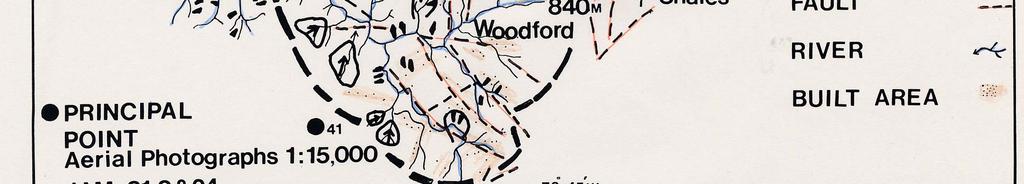
4 Physical Caribbean (From: NEIC, USGS)

5 THE CARIBBEAN Physiography Note: Distribution of land area (brown)
6 PLATE TECTONICS AND NATURAL HAZARDS IN THE CARIBBEAN The theory of plate tectonics is a simple yet comprehensive basis to explain how Earth works and how landforms were shaped. It is an elegant concept in that the theory allows for predictions to be made which could be tested against observations. The theory of plate tectonics thus provides a platform to address a variety of anthropologic/societal concerns in a quantitative/empirical way. Characteristics of tectonic plates, especially plate boundary zones and their working is critical to our understanding of natural hazard processes, for example, how are earthquakes related to plate motions and what sorts of tsunami-generating sources may be found in different types of plate boundaries.

7 PLATE TECTONIC MAP, Modified from Munich Re. The Caribbean plate provides vivid examples of why and how natural hazard processes occur in the Caribbean.

8 EARTHQUAKES AND VOLCANIC ACTIVITY DEFINE THE PRESENT-DAY CARIBBEAN PLATE Earthquake epicentres: black dots and circles. Volcanic centres: red triangles, open-active
9 Plate boundaries and earthquakes in the Caribbean Region From: US Geological Survey


10 The Caribbean Plate Modified from National Geographic Magazine

11 LANDSLIDE TRIGGERS ARE EARTHQUAKES AND RAINFALL. Plate boundary zone of Jamaica, historical tsunami generating earthquakes, and hurricane tracks. The Caribbean Plate is moving east-northeastward at a rate of approximately 18-20mm/yr relative to North America. The plate boundary zone in the vicinity of Jamaica is complex. Hispaniola area: Oblique convergence between the Caribbean Plate and the Bahamas Platform. Jamaica area: Transpression. Cayman area-central America: Strike-slip and transtension. ( Map modified from Grindlay, Hearne, and Mann, 2005) Hurricane Tracks
 Rainy months:")


12 Rainfall (Modified from MunichRe) Rainy months: VI (June)-XII (December) Maximum 24 hr rainfall in mm: Eastern part: Western part:


13 CLIMATE CHANGE (Modified from MunichRe) El Nino year: : Increase in tropical storms in the Pacific Basin Decrease in tropical storm activity in the Atlantic BasinB La Nina year: : Increase in tropical storms in the Atlantic Basin Decrease in tropical storm activity in the Pacific Basin Temperature Change: 1-30C 1 in the Atlantic
14 MULTIPLE NATURAL HAZARDS MAP OF THE CARIBBEAN: VIEW OF THE WORLD S LARGEST RE-INSURER MUNICH RE. (Unit for Disaster Studies Map; modified with permission from Munich Re, 2002).
15 SUMMARY NATURAL HAZARDS ON JAMAICA TROPICAL STORMS and HURRICANES: Zone 4 on Saffir Simpson Scale, Km/h with an exccedance probability of 10% in 10 years (equivalent to return period of 100 years). MAXIMUM 24 HOUR RAINFALL: MM (I/M 2 ) LANDSLIDES; FLOODING; SEDIMENT-WATER FLOODS COAST LINE: Tsunami and Storm surge hazard. EARTHQUAKES: Zone 3 Probable Maximum Intensity MMVIII with an exceedance probability of 10% in 50 years (equivalent to return period of 475 years) for medium subsoil conditions. Kingston: A large city with Mexico City Effect.
16 EARTHQUAKES: Zone 3 to 4: MMI VIII- IX and above Probable maximum intensity (Modified Mercalli Intensity Scale) with an exceedance probability of 10% in 50 years (equivalent to a return period of 475 years) for medium sub-soil soil conditions. Kingston: Large city with Mexico City effect VOLCANOES: Last eruption before 1800 AD Last eruption after 1800 AD Particularly hazardous volcanoes TSUNAMI AND STORM SURGES: Tsunami and storm surge hazard TROPICAL STORMS TRACKS: Probable maximum intensity (SS: Saffir- Simpson hurricane scale) with an exceedance probability of 10% in 10 years(equivalent to a return period of 100 years) Zone 3: SS 3 ( km/hr) Windward Zone 4: SS 4 ( km/hr) Leeward
17 ACTIVE PROCESSES AND LANDFORMS A MODEL OF TROPICAL MONTANE STREAMS
.")
 In the mountains the valleys are narrow and deep with landslide ide-affected slopes and confined stream")
 YALLAHS RIVER, MAVIS BANK (AHMAD, 2005) FAN DELTA OF YALLAHS RIVER IN 1963, TYNDALE")
 Braiding, multiple channels, and bars are found where the valley widens, either locally or near the coastal")
 The depositional forms built by sand, pebbles, cobbles, boulders, and rock blocks are related to both the")
18 IN JAMAICA, MORPHOLOGY OF MONTANE STREAMS ARE LARGELY CONTROLLED BY A PLENTIFUL SUPPLY OF COARSE BEDLOAD FROM LANDSLIDES( AHMAD, SCATENA, and GUPTA, 1993, SED.GEOL. 85, ). A CONCEPTUAL MODEL (1) The drainage density is low with the tributaries joining the main stream at high angles. (2) In the mountains the valleys are narrow and deep with landslide ide-affected slopes and confined stream channels. (3) Stream gradient is high, with local rapids at rock outcrops, or boulder and rock block accumulations. HOPE RIVER (AHMAD, 2003) YALLAHS RIVER, MAVIS BANK (AHMAD, 2005) FAN DELTA OF YALLAHS RIVER IN 1963, TYNDALE BISCOE PHOTO Judgment Cliff Landslide, 1692 (4) Valley alluvium is characterized by extremely coarse sediment. (5) Braiding, multiple channels, and bars are found where the valley widens, either locally or near the coastal plains. In meandering streams an enlargement of point bars in in coarse sediment is common at such places. (6) The depositional forms built by sand, pebbles, cobbles, boulders, and rock blocks are related to both the passage of high magnitude floods and size and d age of the nearest large landslide.

19 Example of a debris fan created by landslides triggered by the rainfall r associated with tropical storm Dennis, June 2005; Yallahs River, Robertsfield, St.Andrew. Note that the sediments in debris fans tend to block the main river course. P. RIVER 2005 LANDSLIDE DEBRIS FAN SEDIMENTS HAVE RAISED THE CHANNEL BY ABOUT 3.0 m Yallahs River
20 HILL SLOPES: Example: Evolution of hillslopes in the Neogene transpressional plate boundary regime of Jamaica is strongly influenced by landslides. Large landslides are typical manifestations of the gravity-induced erosive processes responsible for shaping the mountains and supply sediment to build alluvial fans and fan-deltas in the lowlands. Significance Hazards of slope instability. Sediment flooding. Land degradation. Alluvial fans are not only of academic interest because they offer relatively flat building sites. Alluvial fan flooding. Landslide debris is an economic resource. TRANSPRESSION ON JAMAICA W E W THROUGHGOING FAULT ZONE MAKES A COMPRESSIONAL BEND IN THE ZONE OF LEFT-LATERAL STRIKE-SLIP DEFORMATION NEAR JAMAICA N
21 SATELLITE IMAGE OF SPUR TREE FAULT SCARP AND LANDSLIDES Manchester Plateau Fault Scarp Landslides Alligator Pond


22 Landslide Inventory of Logwood, Lititz, Sea Air, New Forrest, Alligator Pond areas in Manchester. Many of the old landslides were reactivated following the rainfall from tropical storm Emily in July New Forrest to Alligator Pond Road follows a dry river course.


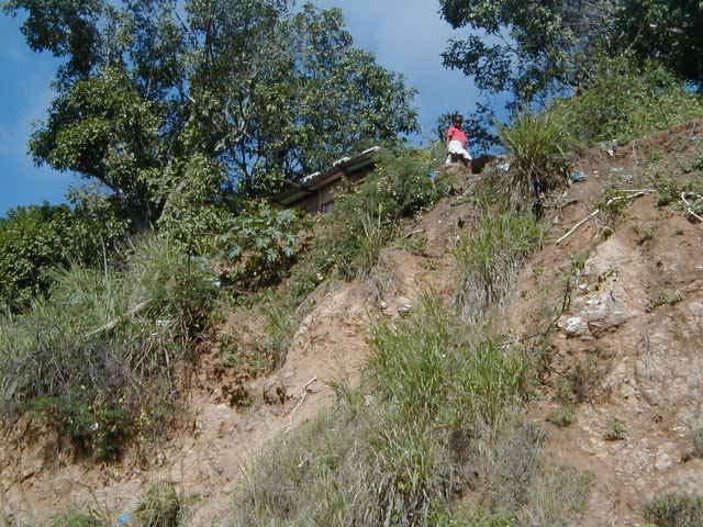
23 Majority of hillslopes in Jamaica are detachment-limited (or loosening limited) that is transportational process operating on the slopes are capable of removing slope materials at a faster rate than it is produced. These slopes are generally steep and are decorated with amphitheatres or landslide hollows. Photo of the Morant River faulted mountain front near Hillside, St.Thomas. ( A Tyndale Biscoe Photo from Buisseret, 1996) Blue Mountain ridge Mt. Mucango landslide Hillside Morant river
 and debris fans (orange lines).")
24 JACKS HILL LANDSLIDE LANDSCAPE. RIDGES ARE RAZOR SHARP, OFTEN ONLY A COUPLE OF METERS WIDE. IN PUERTO RICO, LARSEN AND OTHERS HAVE ESTIMATED SLOPE RECESSION RATES VARYING BETWEEN TO 3.8 mm/yr. BARBICAN HOPE PASTURES Three-dimensional model of the Jack s Hill area showing landslide scars (red lines) and debris fans (orange lines). (Source: Virtual Field Trip DVD- ROM produced for 5 th Faculty of Pure & Applied Sciences Conference, 2005)


25 LANDSLIDE AND FLOOD HAZARDS ALONG THE FAULTED MOUNTAIN FRONT IN LIGUANEA. NATURAL DRAINAGE HAS BEEN COMPROMISED. Sky Line Dr. Sky Line Dr. Forsythe Dr debris flows IVAN RAINFALL MUDFLOWS; SEPT HOPE PASTURES HOPE ZOO VTDI MUD TOWN MUD TOWN UTECH HOPE RIVER MUD TOWN MUD TOWN Retaining Wall VTDI Drainage outlet Road facilitates runoff

26 SPATIAL DISTRIBUTION OF MAJOR KNOWN LANDSLIDES ON JAMAICA. NOTE THE LOCATION OF COASTAL TOWNS ON ANCIENT ALLUVIAL FANS BUILT BY LANDSLIDE DEBRIS. ALLUVIAL FANS ( RED DOTS ) AND FLOODING HAZARD. MODIFIED W.R.A MAP


27 Debris flows, a flow type of landslide, may create spectacular debris fans, for example the Bluefields Debris fan built following the debris flows triggered by 1979 Flood Rains. Bluefields is located on an ancient fan characterized by abandoned dry river channels. Uncertain flowpath flooding is typical of these landforms. DEBRIS FLOWS Bluefields Bay, Westmorland, 12 June 1979 ODPEM WAS ESTABLISHED FOLLOWING THE 12 JUNE 1979 FLOOD RAINS IN WESTERN JAMAICA DEBRIS FAN IN BLUEFIELDS Tyndale Biscoe Photo


28 MAJOR LANDSLIDE ZONES AND FAULT SCARPS LANDSLIDE ZONES WAGWATER BELT STRUCTURAL MAP FROM DRAPER, 1987 FAULT TRENDS
29 LANDSLIDE LANDFORMS COVER km 2, or 3,57% OF THE AREA IN THE PARISHES OF KINGSTON AND ST. ANDREW.
30 GRAVITATIONAL FAILURES AND ACTIVE TECTONICS IN THE LONG MOUNTAIN AREA (Aerial photo from the UWI Cooperative Credit Union Calendar 2002). The Long Mountain is an anticlinal uplift feature aligned NW-SE. Inset shows the present-day left-lateral motion on the Jamaica plate boundary zone. Faults: broken black lines. Landslides: red broken lines, arrow is the movement direction. Debris fans: red dotted line. Rubbly limestone, case hardened E W Site of the M5.4, 1993 earthquake damage RA Debris fans Mona Reservoir Site of new housing development BEVERLY HILLS SCHOOL Liguanea Alluvium: gravel, sand & silt


31 DOMESTIC WATER SUPPLY RESRVOIR SILTATION DUE TO LANDSLIDES
32 EARTHQUAKES HAZARD MAPS INFLUENCE OF GEOLOGY ON EARTHQUAKE PROCESSES CONTROLS


33 Jamaica Seismic Hazard From: Caribbean Disaster Mitigation Project
34 How earthquake waves affect us? JACKS HILL GRANODIORITE LIGUANEA PLAINS Hope Pastures KINGSTON HARBOUR PORT ROYAL Limestone LANDSLIDE DEBRIS FANS FAULT ZONE WATER-SATURATED SEDIMENTS IN GULLY COURSES RECENT SEDIMENTS OF THE LIGUANEA FAN THAT WERE DEPOSITED BY THE HOPE RIVER WHEN IT FLOWED WEST OF ITS PRESENT-DAY COURSE CARTOON TO SHOW THE BEHAVIOUR OF A SET OF EARTHQUAKE WAVES AS THEY TRAVEL THROUGH DIFFERENT TYPES OF SUBSTRATE. NOTE THE AMPLIFICATION OF WAVES IN WATER-SATURATED RECENT SEDIMENTS ENCOUNTERED AT THE LAND-WATER INTERFACE OF KINGSTON HARBOUR AND PORT ROYAL.


35 Seismic Hazard Map for Kingston & St. Andrew
36 HURRICANES STORM SURGE MODELLING
37 Maximum Wave Height (m) for a 50 year return period. From Caribbean Disaster Mitigation Project. Stony Hill KINGSTON STORM HAZARD ASSESSMENT MAX. WAVE HEIGHT (metres) - 50 Year Return Period Red Hills Constant Spring Jacks Hill Gordon Town Mavis Bank 50 Year Return Period Roads Spanish Town Central Village Caymanas Estate Gregory Park Waterford Six Mile Three Mile Halfway Tree New Kingston Cross Roads Papine Rivers Contours Waterbody Maximum Wave Height (metres) Bernard Lodge Braeton Greater Portmore Edgewater Port Royal Fort Clarence Kingston Harbour Parade Norman Manley Int. Airport Rock Fort Harbour View Bull Bay N Hellshire Hills Hellshire Hellshire Bay Hellshire Point C a r i b b e a n S e a Manatee Bay Wreck Bay USAID-OAS CARIBBEAN DISASTER MITIGATION PROJECT KINGSTON STORM HAZARD ASSESSMENT TOAS STORM MODELLING CARRIED OUT BY MARK E. JOHNSON & CHARLES C. WATSON, APRIL Kilometers Map produced by NRCA, June 1999.
38 FLOODING PROCESSES WATER FLOODS SEDIMENT FLOODS
39 Summary Infrastructure Damage from Hydro-geological disasters (Source: Ahmad, 2004) 1. Flood Rains May- June 1986 Cost of repairs to damage/destroyed road network, $16 million Village of Preston. St. Mary destroyed; 17 families displaced; replacement cost in 1986 at $273, Hurricane Gilbert, 1988 Approximately 60 percent of island s water facilities damaged, estimated at 10 million; Boar River Water Supply Pipeline damaged; Repairs to island s road network at $19.3 million; 478 landslides along 108km of roads in the Northwestern St. Andrew, 4percent of total roadway blocked by land slides; Landslides delivered an estimated 20,000m3 of sediments to rivers. 3. Flood Rains May, 1991 Island wide damage at $30 million; Bog Walk Gorge road blocked by a landslide, and road closed for six months 4. Tropical Storm Gordon, November 1994 Approximately 241 km, or 2.3 % of islands total road network damaged; cost $2 million; damage to water systems at $834, Flood Rains, 3-4 January1998 Portland Total damage $7.84 million, land slide damage$4.7 million (60percent of total Damage. Landslide damage: Agriculture Si.4 million, Water Systems $160,000.00, Roads and houses $3.08 million. Period: 1986 to 1998: Total US$86.25 million
40 Tropical Storm Lili and Isadore, September 2002: Summary of Damage (Source: ODPEM, Rapid Impact Assessment Report Tropical Storm Lili and Isadore, 2002) Ministry of Water and Housing: $74,304, Ministry of Agriculture: $309,267, Roads and Infrastructure: $206,100,00.00 Public Utilities: $140,004, Ministry of Health: $54,917, Manufacturing: $55,800, TOTAL (Jamaican $) $ 840,394, (US$1.0 = J$ 50.00)
41 COMPETING CHANNEL PROCESSES IN SMALL DRAINAGE BASINS

42 DEBRIS AVALANCHE Sediment load by weight (%) Bulk Density Mg/m Shear strength N/m 2 >20 Fluid Type Flow rheology Visco-plastic Landform deposits Levees and lobes of largely unsorted material, large clasts on top and at face of lobes
 70-90 Bulk Density Mg/m 3 10-20 Shear strength N/m 2 >20 Fluid Type Flow rheology Visco-plastic Landform deposits Levees and lobes of largely unsorted")
43 1979 FLOOD RAINS IN WESTERN JAMAICA: House at Bluefields almost completely buried as a result of debris flow; Source: The Jamaica Information Service, Photo Library. DEBRIS FLOW Sediment load by weight (%) Bulk Density Mg/m Shear strength N/m 2 >20 Fluid Type Flow rheology Visco-plastic Landform deposits Levees and lobes of largely unsorted material, large clasts on top and at face of lobes

44 DEBRIS FLOW DAMAGE IN THE BYBROOK AREA, PORTLAND, 2001 RAIN STORM. Levees and lobes of largely unsorted material, large clasts on top and at face of lobes

45 DEBRIS FLOODS: Following the October 2002 rainfall, the Chalky River channel in South Eastern St. Andrew was choked by debris. This blockage diverted some of the debris and water east thus aggravating the effects of flooding in the Bull Bay area. This is an upstream view of the silted Chalky River channel. The Bull Bay housing area is located immediately to the right-hand side of the photograph.

46 WATER FLOOD: STREAM FLOW, RIO MINHO, 2004 Sediment load by weight (%) 1-40 Bulk Density Mg/m Shear strength N/m 2 <10 Fluid Type Flow rheology Newtonian Landform deposits Sorted, stratified (Help in identifying with bedforms floods of the past)


47 Tropical Storm Dennis, TRMM Rainfall Image from NASA Impacts of rainfall: Forsythe Drive, Mona Heights & Barbican
48 IN 2004 following hurricane Ivan rainfall and also in 2005 landslide debris again covered the intake. Simple solution: cover the aqueduct, to sustain water supply
49 EARLY WARNING FOR EXAMPLE, LANDSLIDES and SEDIMENT FLOODING RAINFALL THRESHOLDS EARTHQUAKE MAGNITUDE
50
51 RAINFALL THRESHOLDS FOR LANDSLIDES AND SEDIMENT-WATER FLOODS. THE THRESHOLD RELATIONS REPORTED HERE ARE REASONABLE FIRST APPROXIMATIONS. In Jamaica, rainfall threshold relation is defined for storms that had durations between hours and average rainfall intensities between 2-93 mm/h. The threshold relation indicates that for rainfall of short duration (about 1 h): Rainfall Intensities > 36 mm/h are required to trigger landslides. These storms trigger mostly shallow landslides by causing an excess pore pressure in shallow colluvial zones. Such landslides were typically associated with type storms. Low average intensities of about 3mm/h appear to be sufficient to cause landslilding as storm duration approaches approximately 100 h. These storms triggered the largest, deepest landslides in eastern Jamaica, e.g., Flora, Gilbert, 2001 rainfall.
52 Threshold for earthquake-induced landslides in Jamaica. The earthquakes of June 1692 and January 1907 created hundreds of landslides which caused severe deforestation and erosion on the island.
53 IS EXPOSURE TO NATURAL HAZARDS INCREASING? URBAN CENTRES WITH POULATIONS IN EXCESS OF 1000 ARE CONTINUALLY BEING CREATED---INCREASING CONCENTRATION OF PEOPLE AND VALUES COMPLEX UTILITY NETWORKS ARE BEING CREATED THESE ARE EXPOSED TO ALL THE CLASSICAL RISKS THEIR EXPOSURE AND VULNERABITY ARE DISPROPORTIONATE FUTURE DECISIONS ON SITE SELECTION MUST TAKE INTO CONSIDERATION EXISTING KNOWLEDGE AND NEW FINDINGS THE LOSSES THAT MAY BE CAUSED BY NATURAL HAZARDS AND TECHNOLOGICAL RISKS MUST BE IDENTIFIED AND MODELLED IN ADVANCE WE NEED TO DEVELOP NATURAL HAZARD INDEXING AND GEOCODING CRITERIA OF OUR ASSETS- PEOPLES LIVES FIRST WE MUST STRIVE FOR GREATER TRANSPARENCY REGARDING HAZARDS INVOLVED.

54 GROWTH OF KINGSTON DURING HAS TAKEN PLACE ALONG THE LAND-WATER INTERFACE, LANDSLIDE SLOPES AND NATURAL WATER COURSES. FLOODING PROBLEMS: NATURAL WATER COURSES HAVE DISAPPEARED. HOUSING DEVELOPMENT IN DUMPED GULLIES ARE EXPOSED TO SEDIMENT FLOODS AND LIQUEFACTION.
55 Demographic change in Kingston and St. Andrew From STATIN, Jamaica


56 Landslide Isopleth Map illustrating percentage of area covered by landslides, Kingston & St. Andrew; red % area under landslides
57 MANAGEMENT Recommendations from Yokohama Strategy (1994) and World Conference on Disaster Reduction (2005) Disaster response alone is not sufficient to achieve disaster management as it yields only temporary results at a very high cost. Prevention and mitigation activities undertaken before a disaster strikes contribute to lasting improvement in human safety, economic well being, healthy environment and social justice deemed essential to integrated disaster risk management.
58 The challenge for the scientific and technical community is to provide practical strategies for preventive maintenance. It is the statutory obligation of the elected and appointed officials of the government to manage hazards affecting people, infrastructure, and environment. It is argued that preventive maintenance should be based on research, continuous investigation and assessment of hazards, provision of publicly available documentation of hazards, and performance evaluation of preventive maintenance measures.
59 NUTS AND BOLTS FOR MAKING SOUND TECHNICAL DECISIONS TO SUSTAIN SUSTAINABLE DEVELOPMENT IN HAZARD- PRONE TERRAINS AVAILABLE: HAZARD INVENTORY MAPS and HAZARD MAPS WAY FORWARD: VULNERABILITY MAPS and RISK MAPS are required for different hazard magnitudes to decide on acceptable risk and a safe built environment.

60 AVOID BUILDING IN HAZARD PRONE AREAS
61 ROLE OF EARTH SCIENTISTS Natural disaster events are not just a consequence of natural hazards, but an avoidable economic and social catastrophe. Disaster strikes when societies are unable to recognize their responsibility for the proper management of the disaster risks. Jamaica faces several types of geological hazards. A range of geological and geotechnical investigations will form the basis for a comprehensive preventive maintenance programme for disaster mitigation. These are summarized below.
62 Digital surface systems including groundpenetrating radar, electrical resistivity, seismic reflection and refraction, GPS, remote sensed imagery, groundwater movement in slopes, high resolution digital video imaging will dominate digital data collection and interpretation of hazardous geological processes in the new millennium. Excavation techniques have been refined. A National Core Group of practitioners needs to be formulated to oversee the acquisition and application of new technology in preventive measures and practices.
63 It is appropriate at this time to discuss the view put forward by Mr. Roger T. Jones (SOPAC) at the October 2005 Natural Disaster Mitigation Workshop for SIDS in Mauritius: National governments, in pursuance of the principles of good governance and in order to protect the lives and well-being of the peoples they serve, need to recognize their responsibility for the proper management of the disaster risks which may result from the hazards to which their communities may be subject. The scientific community stands ready to assist national governments by informing natural disaster risk management processes.
64
NATURAL HAZARDS PROFILE OF JAMAICA RAFI AHMAD
 NATURAL HAZARDS PROFILE OF JAMAICA RAFI AHMAD rafi.ahmad@uwimona.edu.jm UNIT FOR DISASTER STUDIES DEPARTMENT OF GEOGRAPHY AND GEOLOGY Tel. 1-876-927-2728/2129 Fax: 1-876-977-6029 THE UNIVERSITY OF THE
LAND DEGRADATION IN THE CARIBBEAN: QUATERNARY GEOLOGICAL PROCESSES. RAFI AHMAD
 EXTENDED TASK FORCE MEETING OF PARTICIPATING AGENCIES AND LATIN AMERICAN COUNTRIES FOR ENHANCING SOUTH-SOUTH COOPERATION BETWEEN LAC-CARIBBEAN SIDS PARTNERSHIP INITIATIVE ON LAND DEGRADATION AND SUSTAINABLE
VULNERABILITY OF WATER SUPPLY TO NATURAL HAZARDS IN JAMAICA
 VULNERABILITY OF WATER SUPPLY TO NATURAL HAZARDS IN JAMAICA RAFI AHMAD rafi.ahmad@uwimona.edu.jm Unit for disaster studies, Department of Geography & Geology, The University of the West Indies, Mona Kingston
Debris flow: categories, characteristics, hazard assessment, mitigation measures. Hariklia D. SKILODIMOU, George D. BATHRELLOS
 Debris flow: categories, characteristics, hazard assessment, mitigation measures Hariklia D. SKILODIMOU, George D. BATHRELLOS Natural hazards: physical phenomena, active in geological time capable of producing
Need of Proper Development in Hilly Urban Areas to Avoid
 Need of Proper Development in Hilly Urban Areas to Avoid Landslide Hazard Dr. Arvind Phukan, P.E. Cosultant/Former Professor of Civil Engineering University of Alaska, Anchorage, USA RI District Governor
Earthquake hazards. Aims 1. To know how hazards are classified 2. To be able to explain how the hazards occur 3. To be able to rank order hazards
 Earthquake hazards Aims 1. To know how hazards are classified 2. To be able to explain how the hazards occur 3. To be able to rank order hazards Types of hazard Primary A direct result of the earthquake
OIKOS > landslide > mechanism >predisposing causes
 predisposing causes and trigger OIKOS > landslide > mechanism >predisposing causes Landslides are events that occur in space and time. As such, it is usually possible to identify both one or more landslide
INTRODUCTION. Climate
 INTRODUCTION Climate Landslides are serious natural disasters in many parts of the world. Since the past 30 years, rainfall triggered landslides and debris flows had been one of the natural disasters of
EROSION AND DEPOSITION
 CHAPTER 8 EROSION AND DEPOSITION SECTION 8 1 Changing Earth s Surface (pages 252-255) This section explains how sediment is carried away and deposited elsewhere to wear down and build up Earth s surface.
Disaster Risk Assessment: Opportunities for GIS and data management with Open DRI
 Disaster Risk Assessment: Opportunities for GIS and data management with Open DRI Jacob Opadeyi Department of Geomatics Engineering and Land Management, The University of the West Indies, St. Augustine,
Unit 7.2 W.E.D. & Topography Test
 Name: Score: Unit 7.2 W.E.D. & Topography Test 1. 2. 3. 4. 5. 6. 7. 8. 9. 10. 11. 12. 13. 14. 15. 16. 17. 18. 19. 20. 21. 22. 23. 24. 25. 1. The formation of mountains is due mainly to while the destruction
Erosion Surface Water. moving, transporting, and depositing sediment.
 + Erosion Surface Water moving, transporting, and depositing sediment. + Surface Water 2 Water from rainfall can hit Earth s surface and do a number of things: Slowly soak into the ground: Infiltration
Science EOG Review: Landforms
 Mathematician Science EOG Review: Landforms Vocabulary Definition Term canyon deep, large, V- shaped valley formed by a river over millions of years of erosion; sometimes called gorges (example: Linville
Pacific Catastrophe Risk Assessment And Financing Initiative
 Pacific Catastrophe Risk Assessment And Financing Initiative PALAU September is expected to incur, on average,.7 million USD per year in losses due to earthquakes and tropical cyclones. In the next 5 years,
WATER ON AND UNDER GROUND. Objectives. The Hydrologic Cycle
 WATER ON AND UNDER GROUND Objectives Define and describe the hydrologic cycle. Identify the basic characteristics of streams. Define drainage basin. Describe how floods occur and what factors may make
Mass Wasting: The Work of Gravity
 Chapter 15 Lecture Earth: An Introduction to Physical Geology Twelfth Edition Mass Wasting: The Work of Gravity Tarbuck and Lutgens Chapter 15 Mass Wasting The Importance of Mass Wasting Slopes are the
Natural hazards in Glenorchy Summary Report May 2010
 Natural hazards in Glenorchy Summary Report May 2010 Contents Glenorchy s hazardscape Environment setting Flood hazard Earthquakes and seismic hazards Hazards Mass movement Summary Glossary Introduction
Gateway Trail Project
 Gateway Trail Project Debris Flow Hazard Assessment By: Juan de la Fuente April 30, 2010 Background- On April 22, 2010, the Shasta-Trinity National Forest (Mt. Shasta-McCloud Unit) requested a geologic
Term Knowledge Using and applying Grade Criteria Autumn 1 Assessment window October Natural hazards pose major risks to people and property.
 Assessment Schedule Year 9 2015/6 Term Knowledge Using and applying Grade Criteria Autumn 1 Assessment window October 2015 3.1.1.2 Tectonic Natural hazards pose major risks to people and property. Definition
Earthquake Hazards. Tsunami
 Earthquake Hazards Tsunami Measuring Earthquakes Two measurements that describe the power or strength of an earthquake are: Intensity a measure of the degree of earthquake shaking at a given locale based
Pacific Catastrophe Risk Assessment And Financing Initiative
 Pacific Catastrophe Risk Assessment And Financing Initiative VANUATU September 211 Country Risk Profile: VANUATU is expected to incur, on average, 48 million USD per year in losses due to earthquakes and
3.18 GEOLOGY AND SOILS
 3.18 GEOLOGY AND SOILS This section discusses geologic resource concerns as they relate to the environment, public safety, and project design both during construction and after completion of the project.
3/3/2013. The hydro cycle water returns from the sea. All "toilet to tap." Introduction to Environmental Geology, 5e
 Introduction to Environmental Geology, 5e Running Water: summary in haiku form Edward A. Keller Chapter 9 Rivers and Flooding Lecture Presentation prepared by X. Mara Chen, Salisbury University The hydro
Mass Wasting. Revisit: Erosion, Transportation, and Deposition
 Mass Wasting Revisit: Erosion, Transportation, and Deposition While landslides are a normal part of erosion and surface processes, they can be very destructive to life and property! - Mass wasting: downslope
STUDY GUIDE FOR CONTENT MASTERY. Surface Water Movement
 Surface Water SECTION 9.1 Surface Water Movement In your textbook, read about surface water and the way in which it moves sediment. Complete each statement. 1. An excessive amount of water flowing downslope
Using Weather and Climate Information for Landslide Prevention and Mitigation
 Using Weather and Climate Information for Landslide Prevention and Mitigation Professor Roy C. Sidle Disaster Prevention Research Institute Kyoto University, Japan International Workshop on Climate and
Pacific Catastrophe Risk Assessment And Financing Initiative
 Pacific Catastrophe Risk Assessment And Financing Initiative TIMOR-LESTE September Timor-Leste is expected to incur, on average, 5.9 million USD per year in losses due to earthquakes and tropical cyclones.
Think about the landforms where you live. How do you think they have changed over time? How do you think they will change in the future?
 reflect All the landforms on Earth have changed over time and continue to change. Many of the changes were caused by wind, moving water, and moving ice. Mountains have grown and shrunk. Rivers have cut
Earthquake Hazards. Tsunami
 Earthquake Hazards Tsunami Review: What is an earthquake? Earthquake is the vibration (shaking) and/or displacement of the ground produced by the sudden release of energy. The point inside the Earth where
Pacific Catastrophe Risk Assessment And Financing Initiative
 Pacific Catastrophe Risk Assessment And Financing Initiative TUVALU is expected to incur, on average,. million USD per year in losses due to earthquakes and tropical cyclones. In the next 5 years, has
Beyond the Book. FOCUS Book
 FOCUS Book Suppose your city wants to build a new housing development on a steep slope outside town. Design a model to test whether the land is safe from the types of landslides you read about in this
Your web browser (Safari 7) is out of date. For more security, comfort and the best experience on this site: Update your browser Ignore
 is out of date. For more security, comfort and the best experience on this site: Update your browser Ignore") Your web browser (Safari 7) is out of date. For more security, comfort and the best experience on this site: Update your browser Ignore ALLU VIAL FAN colluvial fan, debris cone For the complete encyclopedic
Your web browser (Safari 7) is out of date. For more security, comfort and the best experience on this site: Update your browser Ignore ALLU VIAL FAN colluvial fan, debris cone For the complete encyclopedic
Changes to Land 5.7B. landforms: features on the surface of Earth such as mountains, hills, dunes, oceans and rivers
 All the landforms on Earth have changed over time and continue to change. Many of the changes were caused by wind, moving water, and moving ice. Mountains have grown and shrunk. Rivers have cut away land
USGS scientists with Venezuelan military liaisons.
 USGS scientists with Venezuelan military liaisons. In December, 1999, heavy rainfall triggered thousands of debris flows and caused numerous flash floods in a 300- kilometer long area of the north coast
What type of land feature is located at Point A? A Cliff B Delta C Mountain D Valley
 1 What type of land feature is located at Point A? A Cliff B Delta C Mountain D Valley Alfred Wegener s theory of continental drift was 2 not accepted by scientists when the theory was first proposed.
GEOL 1121 Earth Processes and Environments
 GEOL 1121 Earth Processes and Environments Wondwosen Seyoum Department of Geology University of Georgia e-mail: seyoum@uga.edu G/G Bldg., Rm. No. 122 Seyoum, 2015 Chapter 6 Streams and Flooding Seyoum,
Debris Avalanches. Debris avalanche deposits on a volcano in Chile. All of the area in the foreground is buried by a thick debris avalanche.
 Debris Avalanches Volcanoes are not very stable structures. From time to time, they collapse producing large rock and ash avalanches that travel at high speeds down valleys. Collapse maybe caused by an
Earth Science Chapter 9. Day 6 - Finish Capillary Action Lab - Quiz over Notes - Review Worksheets over Sections 9.2 and 9.3
 Earth Science Chapter 9 Day 1 Day 2 Day 3 Read Section 9.1 Surface Water Chapter 9 Term Sheet Notes over Section 9.1 Surface Water Section 9.1 Review Worksheets Quiz over Section 9.1 Notes Virtual Lab
Candidate Name Centre Number Candidate Number CHANGING PHYSICAL AND HUMAN LANDSCAPES SAMPLE ASSESSMENT MATERIALS
 GCSE GEOGRAPHY Sample Assessment Materials 5 Candidate Name Centre Number Candidate Number 0 GCSE GEOGRAPHY UNIT 1 CHANGING PHYSICAL AND HUMAN LANDSCAPES SAMPLE ASSESSMENT MATERIALS 1 hour 30 minutes Section
Earthquake Hazards. Tsunami
 Earthquake Hazards Tsunami Review: What is an earthquake? Earthquake is the vibration (shaking) and/or displacement of the ground produced by the sudden release of energy. The point inside the Earth where
New GCSE Geography AQA
 Learning Checklist Half Term 1 26 th September 3 rd October 10 th October 17 th October 1.1.1 Tectonic Hazards Plate tectonics theory. Global distribution of earthquakes and volcanic eruptions and their
STATUS OF HAZARD MAPS VULNERABILITY ASSESSMENTS AND DIGITAL MAPS
 JapanInternational Cooperation Agency STATUS OF HAZARD MAPS VULNERABILITY ASSESSMENTS AND DIGITAL MAPS ANGUILLA REPORT THE CARIBBEAN DISASTER EMERGENCY RESPONSE AGENCY () Table of Contents Page Preface
Tropical Cyclone Sandy (AL182012)
") Tropical Cyclone Sandy (AL182012) Event Briefing Caribbean Risk Managers Ltd Facility Supervisor 29 October 2012 Facility Supervisor: Caribbean Risk Managers Ltd Email: ccrif@ccrif.org Tel (Barbados):
Tropical Cyclone Sandy (AL182012) Event Briefing Caribbean Risk Managers Ltd Facility Supervisor 29 October 2012 Facility Supervisor: Caribbean Risk Managers Ltd Email: ccrif@ccrif.org Tel (Barbados):
Fukien Secondary School Monthly Vocabulary/Expression List for EMI Subjects Secondary Two. Subject: Geography
 Focus: General Specific : Section Two : Unit One 1 Landslide 2 Downslope movement 3 Rock 4 Soil 5 Gravity 6 Natural hazard 7 Rainwater 8 Friction 9 Hilly relief 10 Unstable 11 Season 12 Saturated 13 Construction
SLOPE PROCESSES, LANDSLIDES, AND SUBSIDENCE
 CHAPTER 9 SLOPE PROCESSES, LANDSLIDES, AND SUBSIDENCE La Conchita slide January 10, 2005 Triggered by heavy rainfall, reactivation along an older landslide surface (35,000 years ago, 6000 years ago, and
Year 6. Geography. Revision
 Year 6 Geography Revision November 2017 Rivers and World knowledge How the water cycle works and the meaning of the terms evaporation, condensation, precipitation, transpiration, surface run-off, groundwater
Rivers and Landslides
 Rivers and Landslides Path of desire or path of least resistance? Desire Path: A term in landscape architecture used to describe a path that isn t designed but rather is worn casually away by people finding
ES 105 Surface Processes I. Hydrologic cycle A. Distribution % in oceans 2. >3% surface water a. +99% surface water in glaciers b.
 ES 105 Surface Processes I. Hydrologic cycle A. Distribution 1. +97% in oceans 2. >3% surface water a. +99% surface water in glaciers b. >1/3% liquid, fresh water in streams and lakes~1/10,000 of water
GEOG 1010A. Come to the PASS workshop with your mock exam complete. During the workshop you can work with other students to review your work.
 It is most beneficial to you to write this mock midterm UNDER EXAM CONDITIONS. This means: Complete the midterm in 1.5 hours. Work on your own. Keep your notes and textbook closed. Attempt every question.
CHAPTER GEOLOGICALLY HAZARDOUS AREAS Applicability Regulations.
 CHAPTER 19.07 GEOLOGICALLY HAZARDOUS AREAS 19.07.010 Applicability. Geologically hazardous areas may pose a threat to the health and safety of citizens when incompatible development is sited in areas of
International Journal of Modern Trends in Engineering and Research e-issn No.: , Date: April, 2016
 International Journal of Modern Trends in Engineering and Research www.ijmter.com e-issn No.:2349-9745, Date: 28-30 April, 2016 Landslide Hazard Management Maps for Settlements in Yelwandi River Basin,
3/8/17. #20 - Landslides: Mitigation and Case Histories. Questions for Thought. Questions for Thought
 #20 - Landslides: Mitigation and Case Histories Web Exercise #3 (Volcanoes) Due Wednesday There is a 2-point penalty for every day the assignment is late. Exam 1 Scores Scores and exam key are posted Vaiont
3.12 Geology and Topography Affected Environment
 3 Affected Environment and Environmental Consequences 3.12 Geology and Topography 3.12.1 Affected Environment 3.12.1.1 Earthquakes Sterling Highway MP 45 60 Project Draft SEIS The Kenai Peninsula is predisposed
Interpretive Map Series 24
 Oregon Department of Geology and Mineral Industries Interpretive Map Series 24 Geologic Hazards, and Hazard Maps, and Future Damage Estimates for Six Counties in the Mid/Southern Willamette Valley Including
PHYSICAL GEOGRAPHY. By Brett Lucas
 PHYSICAL GEOGRAPHY By Brett Lucas FLUVIAL PROCESSES Fluvial Processes The Impact of Fluvial Processes on the Landscape Streams and Stream Systems Stream Channels Structural Relationships The Shaping and
9/13/2011 CHAPTER 9 AND SUBSIDENCE. Case History: La Conchita Landslide. Introduction
 CHAPTER 9 SLOPE PROCESSES, LANDSLIDES, AND SUBSIDENCE Case History: La Conchita Landslide La Conchita: small coastal community 80 km (50 mi) northwest of Los Angeles Landslide occurred on January 10, 2005
Magnitude 6.3 SOUTH ISLAND OF NEW ZEALAND
 A magnitude 6.3 earthquake shook the southern New Zealand city of Christchurch. At least 100 people are reported dead, and there are reports of collapsed buildings, cracked streets and flooding due to
Page 1. Name:
 Name: 1) Which event is the best example of erosion? dissolving of rock particles on a limestone gravestone by acid rain breaking apart of shale as a result of water freezing in a crack rolling of a pebble
Weathering, Erosion, Deposition, and Landscape Development
 Weathering, Erosion, Deposition, and Landscape Development I. Weathering - the breakdown of rocks into smaller particles, also called sediments, by natural processes. Weathering is further divided into
Activity Pacific Northwest Tectonic Block Model
 Activity Pacific Northwest Tectonic Block Model The Cascadia tectonic margin is caught between several tectonic forces, during the relentless motions of the giant Pacific Plate, the smaller subducting
Initiative. Country Risk Profile: papua new guinea. Better Risk Information for Smarter Investments PAPUA NEW GUINEA.
 Pacific Catastrophe Risk Assessment And Financing Initiative PAPUA NEW GUINEA September 211 Country Risk Profile: papua new is expected to incur, on average, 85 million USD per year in losses due to earthquakes
1. Erosion by Running Water Most powerful cause of erosion
 I. Destructive Forces Notes: Destructive force: a process in which land is destroyed or changed such as weathering and erosion. All landforms are a result of a combination of constructive and destructive
Read Across America. Listen as I read for facts about Volcanoes. In the Shadow of the Volcano
 Read Across America Listen as I read for facts about Volcanoes. In the Shadow of the Volcano Constructive & Destructive Processes Earth s surface is always changing. Blowing wind and flowing water causes
Phillip Island Nature Parks Coastal Process Study 8 October 2014
 Phillip Island Nature Parks Coastal Process Study 8 October 2014 Project Overview Coastal Geology Basaltic and fragmented lavas, granite at Pyramid Rock and Cape Woolamai Weathered basalt (>10m thick)
Name. 4. The diagram below shows a soil profile formed in an area of granite bedrock. Four different soil horizons, A, B, C, and D, are shown.
 Name 1. In the cross section of the hill shown below, which rock units are probably most resistant to weathering? 4. The diagram below shows a soil profile formed in an area of granite bedrock. Four different
New A-Level Physical Geography
 Half Term 1 3.1 Physical Geography: 3.1.5 Hazards: Plate Tectonics This optional section of our specification focuses on the lithosphere and the atmosphere, which intermittently but regularly present natural
Important Concepts. Earthquake hazards can be categorized as:
 Lecture 1 Page 1 Important Concepts Monday, August 17, 2009 1:05 PM Earthquake Engineering is a branch of Civil Engineering that requires expertise in geology, seismology, civil engineering and risk assessment.
RISK ASSESSMENT COMMUNITY PROFILE NATURAL HAZARDS COMMUNITY RISK PROFILES. Page 13 of 524
 RISK ASSESSMENT COMMUNITY PROFILE NATURAL HAZARDS COMMUNITY RISK PROFILES Page 13 of 524 Introduction The Risk Assessment identifies and characterizes Tillamook County s natural hazards and describes how
GG101 Lecture 22: Mass Wasting. Soil, debris, sediment, and broken rock is called regolith.
 GG101 Lecture 22: Mass Wasting Mass Wasting is the movement of rock and soil down a slope due to the force of gravity. Soil, debris, sediment, and broken rock is called regolith. Mass wasting creates broad
Stewards Pooi Kei College TEACHING SCHEDULE ( ) Form: S4 Subject : Geography No. of periods per cycle: 9 Teacher: Mr. Eric Chau Year/Month
 Form: S4 Subject : Geography No. of periods per cycle: 9 Teacher: Mr. Eric Chau Year/Month") Form: S4 Subject : Geography No. of periods per cycle: 9 Teacher: Mr. Eric Chau Year/Month 2009 September October November Topics / Subjects to be covered skills (if any) Remarks Cycle 1 What is tropical
Form: S4 Subject : Geography No. of periods per cycle: 9 Teacher: Mr. Eric Chau Year/Month 2009 September October November Topics / Subjects to be covered skills (if any) Remarks Cycle 1 What is tropical
Ch 10 Deposition Practice Questions
 1. Base your answer to the following question on the data table below. Six identical cylinders, A through F, were filled with equal volumes of sorted spherical particles. The data table shows the particle
Baldwin County, Alabama
 2015 Baldwin County, Alabama Multi-Hazard Mitigation Plan I. Comprehensive Plan A multi-jurisdiction plan City of Bay Minette City of Daphne Town of Elberta City of Fairhope City of Foley City of Gulf
Continental Landscapes
 Continental Landscapes Landscape influenced by tectonics, climate & differential weathering Most landforms developed within the last 2 million years System moves toward an equilibrium Continental Landscapes
SITUATION REPORT OFFICE OF DISASTER PREPAREDNESS
 SITUATION REPORT OFFICE OF DISASTER PREPAREDNESS AND EMERGENCY MANAGEMENT DATE: TIME: EVENT: October 23-24, 2012 5:30 a.m. Tropical Storm Sandy DATE OF EVENT: October 23, 2012, 2012 SITUATION REPORT NO.:
3 Erosion and Deposition by Ice
 CHAPTER 12 3 Erosion and Deposition by Ice SECTION Agents of Erosion and Deposition BEFORE YOU READ After you read this section, you should be able to answer these questions: What are glaciers? How do
Pratice Surface Processes Test
 1. The cross section below shows the movement of wind-driven sand particles that strike a partly exposed basalt cobble located at the surface of a windy desert. Which cross section best represents the
Which map shows the stream drainage pattern that most likely formed on the surface of this volcano? A) B)
 B)") 1. When snow cover on the land melts, the water will most likely become surface runoff if the land surface is A) frozen B) porous C) grass covered D) unconsolidated gravel Base your answers to questions
1. When snow cover on the land melts, the water will most likely become surface runoff if the land surface is A) frozen B) porous C) grass covered D) unconsolidated gravel Base your answers to questions
water erosion lithosphere Describe the process of erosion and deposition. chemical weathering Dissolving limestone is an example of.
 At one time, there was one large island off the coast of Mississippi and now it is two separate islands. What caused the island to be split into two? water erosion The crust and the top part of the upper
Word Cards. 2 map. 1 geographic representation. a description or portrayal of the Earth or parts of the Earth. a visual representation of an area
 Name: Date: Hour: Word Cards 1 geographic representation a description or portrayal of the Earth or parts of the Earth Example: A map is a representation of an actual location or place. 2 map a visual
Flooding in Western North Carolina: Some Spatial, Hydrologic, and Seasonal Characteristics CAUTION!! Outline. Basic Flood Facts.
 Flooding in Western North Carolina: Some Spatial, Hydrologic, and Seasonal Characteristics J. Greg Dobson CAUTION!! National Environmental Modeling and Analysis Center RENCI at UNC-Asheville Engagement
River Response. Sediment Water Wood. Confinement. Bank material. Channel morphology. Valley slope. Riparian vegetation.
 River Response River Response Sediment Water Wood Confinement Valley slope Channel morphology Bank material Flow obstructions Riparian vegetation climate catchment vegetation hydrological regime channel
STREAM SYSTEMS and FLOODS
 STREAM SYSTEMS and FLOODS The Hydrologic Cycle Precipitation Evaporation Infiltration Runoff Transpiration Earth s Water and the Hydrologic Cycle The Hydrologic Cycle The Hydrologic Cycle Oceans not filling
Precipitation Evaporation Infiltration Earth s Water and the Hydrologic Cycle. Runoff Transpiration
 STREAM SYSTEMS and FLOODS The Hydrologic Cycle Precipitation Evaporation Infiltration Earth s Water and the Hydrologic Cycle Runoff Transpiration The Hydrologic Cycle The Hydrologic Cycle Oceans not filling
Lecture Outline Wednesday-Monday April 18 23, 2018
 Lecture Outline Wednesday-Monday April 18 23, 2018 Questions? Lecture Final Exam Lecture Section 1 Friday May 4, 8:00-10:00am Lecture Section 2 Friday May 4, 3:10-5:10 pm Final Exam is 70% new material
Name: Which rock layers appear to be most resistant to weathering? A) A, C, and E B) B and D
 A, C, and E B) B and D") Name: 1) The formation of soil is primarily the result of A) stream deposition and runoff B) precipitation and wind erosion C) stream erosion and mass movement D) weathering and biological activity 2)
Name: 1) The formation of soil is primarily the result of A) stream deposition and runoff B) precipitation and wind erosion C) stream erosion and mass movement D) weathering and biological activity 2)
The Effects of Hydraulic Structures on Streams Prone to Bank Erosion in an Intense Flood Event: A Case Study from Eastern Hokkaido
 Symposium Proceedings of the INTERPRAENENT 2018 in the Pacific Rim The Effects of Hydraulic Structures on Streams Prone to Bank Erosion in an Intense Flood Event: A Case Study from Eastern Hokkaido Daisuke
Mass Wasting. Requirements for Mass Wasting. Slope Stability. Geol 104: mass wasting
 Mass Wasting Movement of earth materials downslope, driven by Gravitational Forces. Landslides - general term for rock or soil movement. In U.S., on average, mass wasting causes 1 to 2 billion dollars
Was the Palisadoes ever an island? Will it become one in the future?
 The Island of the Palisadoes? Edward Robinson and Deborah-Ann Rowe Marine Geology Unit Department of Geography and Geology University of the West Indies Mona, Kingston 7, Jamaica mgu@uwimona.edu.jm Was
UNIT 11 SOUTH ASIA SG 1 - PHYSICAL GEOGRAPHY & THE ENVIRONMENT
 UNIT 11 SOUTH ASIA SG 1 - PHYSICAL GEOGRAPHY & THE ENVIRONMENT I. PHYSICAL GEOGRAPHY TAKE OUT YOUR PHYSICAL MAP OF SOUTH ASIA A. The Himalayan Mountains form the northern boundary of the region (color
depression above scarp scarp
 1 LAB 1: FIELD TRIP TO McKINLEYVILLE AND MOUTH OF THE MAD RIVER OBJECTIVES: a. to look at geomorphic and geologic evidence for large scale thrust-faulting of young sediments in the Humboldt Bay region
Geography Class XI Fundamentals of Physical Geography Section A Total Periods : 140 Total Marks : 70. Periods Topic Subject Matter Geographical Skills
 Geography Class XI Fundamentals of Physical Geography Section A Total Periods : 140 Total Marks : 70 Sr. No. 01 Periods Topic Subject Matter Geographical Skills Nature and Scope Definition, nature, i)
Examining the Terrestrial Planets (Chapter 20)
") GEOLOGY 306 Laboratory Instructor: TERRY J. BOROUGHS NAME: Examining the Terrestrial Planets (Chapter 20) For this assignment you will require: a calculator, colored pencils, a metric ruler, and your geology
GEOLOGY 306 Laboratory Instructor: TERRY J. BOROUGHS NAME: Examining the Terrestrial Planets (Chapter 20) For this assignment you will require: a calculator, colored pencils, a metric ruler, and your geology
Fresh Water: Streams, Lakes Groundwater & Wetlands
 Fresh Water:, Lakes Groundwater & Wetlands Oct 27 Glaciers and Ice Ages Chp 13 Nov 3 Deserts and Wind and EXAM #3 Slope hydrologic cycle P = precip I = precip intercepted by veg ET = evapotranspiration
M14/3/GEOGR/SP2/ENG/TZ0/XX/Q GEOGRAPHY STANDARD LEVEL PAPER 2. Monday 19 May 2014 (morning) 1 hour 20 minutes INSTRUCTIONS TO CANDIDATES
 1 hour 20 minutes INSTRUCTIONS TO CANDIDATES") M14/3/GEOGR/SP2/ENG/TZ0/XX/Q 22145203 GEOGRAPHY STANDARD LEVEL PAPER 2 Monday 19 May 2014 (morning) 1 hour 20 minutes INSTRUCTIONS TO CANDIDATES Do not open this examination paper until instructed to do
M14/3/GEOGR/SP2/ENG/TZ0/XX/Q 22145203 GEOGRAPHY STANDARD LEVEL PAPER 2 Monday 19 May 2014 (morning) 1 hour 20 minutes INSTRUCTIONS TO CANDIDATES Do not open this examination paper until instructed to do
LANDSLIDE HAZARDS. presented during the. TRAINING-WORKSHOP ON DISASTER RISK MANAGEMENT Rakdell Inn Virac, Catanduanes 03 July 2008
 LANDSLIDE HAZARDS presented during the TRAINING-WORKSHOP ON DISASTER RISK MANAGEMENT Rakdell Inn Virac, Catanduanes 03 July 2008 GEOLOGIC HAZARDS the probability of occurrence, within a specific period
 Page 1 of 9 Name: Base your answer to the question on the diagram below. The arrows show the direction in which sediment is being transported along the shoreline. A barrier beach has formed, creating a
Climate Change Impacts and Adaptation for Coastal Transport Infrastructure in Caribbean SIDS
 UNCTAD National Workshop Saint Lucia 24 26 May 2017, Rodney Bay, Saint Lucia Climate Change Impacts and Adaptation for Coastal Transport Infrastructure in Caribbean SIDS Impacts of Natural Hazards on the
Step 5: Channel Bed and Planform Changes
 Step 5: Channel Bed and Planform Changes When disturbed, streams go through a series of adjustments to regain equilibrium with the flow and sediment supply of their watersheds. These adjustments often
What do you need for a Marathon?
 What do you need for a Marathon? Water and a snack? What about just a normal day? 1 flush = 3.5 gallons 1 flush = 3.5 gallons 10 minute shower = 20 gal 1 flush = 3.5 gallons 10 minute shower = 20 gal Jeans
11/12/2014. Running Water. Introduction. Water on Earth. The Hydrologic Cycle. Fluid Flow
 Introduction Mercury, Venus, Earth and Mars share a similar history, but Earth is the only terrestrial planet with abundant water! Mercury is too small and hot Venus has a runaway green house effect so