Prospect Lake Property
|
|
|
- Randolf Morton
- 6 years ago
- Views:
Transcription
1 Work Assessment Report Prospect Lake Property Coldwell Thunder Bay District Ontario NTS 42 D/15 Assembled by: John Florek Date: December 03, 2015
2 Table of Contents Summary. Pg. 1 Introduction.. Pg. 1 Regional Geology. Pg. 1 Property Geology. Pg. 1 Historical Work Performed... Pg. 4 Work Program. Pg. 4 Recommendations.. Pg. 5 References... Pg. 8 Figure 1 (Regional Location Map). Pg. 2 Figure 2 (Property Location Map)... Pg. 3 Figure 3 (Outcrop Location Map). Pg. 6 Figure 4 (Geology Map) Pg. 7 Appendix A Costs and Invoices Appendix B Outcrop Notes and Photographs Appendix C Assessment Work Performed on Mining Lands
3 Summary: A mapping and prospecting program was initiated to follow up on historical results of an identified exhalative unit that occurs at the boundary between sediments and mafic volcanics. An attempt to find this horizon, projected to the surface, was the focus of this work program. This would enable a better understanding of the structural setting, stratigraphy, and exploration of this key horizon which has already demonstrated significant base metal occurrences. Several traverses crossing this horizon, where the exhalative unit should project to surface, were accomplished. Limited exposure made it difficult to locate this horizon, but with digging in the vicinity of the projected zone the horizon was eventually located. Introduction: John Florek has 100% interest in the Prospect Lake Property located in Coldwell Area of the Thunder Bay District, Ontario, within the Schreiber Greenstone Belt. The Property consists of eighteen (2) claims (24 claim units). Table 1 and Figure 1 and 2 show the location of the group of claims. Prospect Lake Property Claim Number Number of Claim Units Table 1: Claims The Prospect Lake property is located 6.5 kilometres north of the TransCanada Highway, between Marathon and Terrance Bay, Ontario. The property is accessible by ATV trail, canoe, and forest trail to the southeastern area of claim All of the claim area is very remote and most of the areas are only accessible by walking through the boreal forest. Regional Geology The property occurs within the Wawa Subprovince of the Superior Province. It is within the late Archean Schreiber-Hemlo greenstone belt, i.e., Ga. It is composed of supracrustal lithotectonic assemblages of ultramafic to tholeiitic basalt ocean plateau sequences, tholeiitic to calc-alkaline volcanic arc sequences, and siliciclastic turbidites, collectively intruded by arc granitoids (Polet et.al ) Property Geology The property lies along the north limb of a regional antiform, which is located in the Archean Schreiber portion of the greenstone belt. Mafic and Intermediate volcanics are overlain by chert, shale, sulphide iron formation, and related sedimentary rocks. The belt consists of variably metamorphosed metavolcanic and metasedimentary units. Figure 4 shows the property geology; taken from Walker
4 Ogoki Lake Figure 1. Northwestern Ontario Location Map Prospect Lake Property Ogoki Reservoir Lake Nipigon Long Lake ^ Prospect Lake Property! Communities Trans Canada Highway Hwy 614 Manitouwadge! Water Prospect Lake Property Dog Lake Kabinakagami Lake ^ Marathon! 1:3,000,000 0 Thunder Bay km! Lake Superior Produced by Florek Consulting Services under licence from Ontario Ministry of Natural Resources, Copyright (c) Queens Printer Vector Base Data supplied by the MNR. UTM Projection, NAD83, Zone 16! Sault Ste. Marie Ontario! Prospect Lake Property Lake Michigan 2 Lake Huron


5 515,000 me 514,000 me 513,000 me 512,000 me 511,000 me 510,000 me 509,000 me 5,413,000 mn 5,413,000 mn 5,412,000 mn 5,412,000 mn Figure 2: Claim Map (1 : 25,000) 515,000 me 514,000 me 3 513,000 me 5,409,000 mn 512,000 me 5,410,000 mn 511,000 me 5,410,000 mn 510,000 me 5,411,000 mn 509,000 me 5,411,000 mn 5,409,000 mn
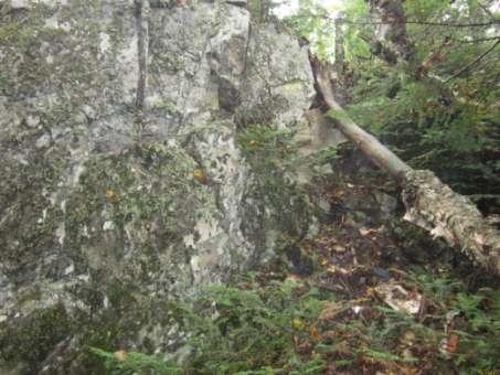
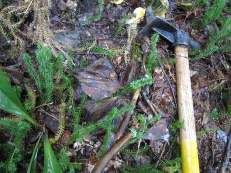
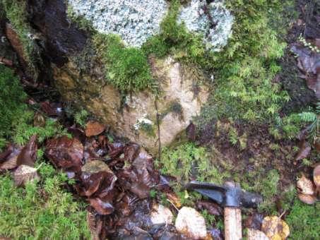
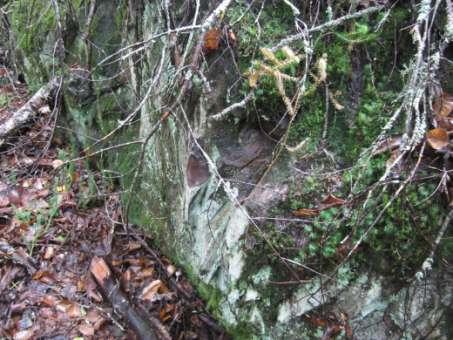
6 Historical Work Performed Several previous companies have worked the property and the information is contained in the assessment files located at the MNDM. Brief synopses below of work performed on these properties are contained in these reports. A lot of the reports describe more regional surveys over the general area, but the list below is confined to the claims in this report. 1981: Gulf? 1983: Coronet Resources: Aerodat Ltd airborne geophysical surveys, geological survey, geochemical survey (42D15SW0082,70). 1983: Teck Exploration: Geophysics (42D15SW0090) 1986: Lionel Martin: Linecutting, Trenching, Geochemistry, Geological Mapping, Geochemistry, Geophysics, and Diamond Drilling (42D15SW0061) : Eldor Resources (optioned from Cunningham): Diamond Drilling, Soil Sampling, Lithogeochemistry (42D15SW0064, 56_b, 58) 1989: Cameco / Zenmac Zinc Ltd: Diamond Drilling (42D15SW0054,56) 1990: Cunningham: Whole Rock Analysis (42D15SW0051), references Gulf work? 2005: Phoenix Matachewan Mines: Lithogeochemistry, Airborne Magnetics, VTEM (42D15SW0061, 2025, ) : Galahad Minerals: Drilling 2012: Wayne Richards: Prospecting and bedrock sampling ( ) Work Program The main goal was to identify and prospect the area where an exhalitive horizon trends through the claims and to determine if a soil gas survey would be appropriate to identify increased sulphidation along this known horizon in planned future exploration work. This work will guide the next phase of exploration on the property and its implementation. A review of the historical work was performed on the property prior to field work. Attempts were made to put pertinent historical information into a GIS format, so that precise areas could be located since all established surface grids are now somewhat overgrown. This was the basis for prospecting and collecting outcrop samples to follow up on previously mapped areas, in hopes of identifying new showings. Samples that were identified and recorded are shown in Figure 3 and Appendix B. This exhalative horizon is known to be composed of chert, iron oxide and sulphide facies iron formation, and locally intercalated graphitic schists. This horizon has significant untested strike length and is one of the most continuous and thickest exhalite horizons in the greenstone belt shown on Walker s (1953) 4
7 geological map. The prospecting was done between known lithogeochemistry done by Phoenix Matachewan Mines, to hopefully identify new showings or unknown rock types. Lateral to this horizon, just off the claims is a diamond drillhole intercept that contained 8.6% Zn over 10 meters. The area of prospecting is located on the northern flanks of a regional magnetic high, in an area of magnetic low. This is a similar spatial location of the diamond drillhole intercept on the adjacent property which intercepted 8.6% over 10 meters. It is also spatially close to a determined syncline in the stratigraphy, which could be very important in creating structural traps for massive sulpides. Part of the prospecting was to see if any fold hinges were seen in the outcrops. Prospecting revealed that the exhalite horizon is more complex than shown on the map. Mafic volcanics and sediments were seen within this mapped exhalite horizon, constructed by Walker (1953). It appears that there are probably several horizons of exhalites that need to be further delineated with additional prospecting, geophysics or geochemistry. In addition to prospecting, trails were cut for safety reasons, to provide easy ingress and egress to the property and to re-establish claim boundaries where they were difficult to discern. An emergency shelter was also constructed, due to the remoteness of the claim group. GPS mapping, of former existing trails, were also accomplished; to provide future access to historical drillholes and future unencumbered entry to property. Recommendations Further investigations of these occurrences are warranted. It is suggest that the following be accomplished: Follow-up of geochemical (soils, rocks, gas) and geophysical surveys. The reestablishment of overgrown trails to provide better access. Additional evaluation of the historical geochemical dataset. 5

8 513,000 me 514,000 me 5,412,000 mn 5,412,000 mn BZ013 BZ014 BZ019 BZ015 BZ021 BZ012 BZ020 BZ BZ018 BZ016 BZ017 BZ006 BZ007 BZ008BZ009 BZ005 BZ003 BZ001 BZ002 BZ010 BZ004 5,411,000 mn 5,411,000 mn Figure 3: Outcrop Locations 513,000 me 6 514,000 me

9 Prospect Lake Geology Prospect Lake Property Geology Intrusive Exhalite Sediments FeFm Figure 4: Geology Mafic Volcanics Diabase Dikes Intermediate Volcanics After J.W.R. Walker Scale m 1 Kilometer
10 References Polat, R. Kerrich, and D.A. Wyman (1998). The late Archean Schreiber Hemlo and White River Dayohessarah greenstone belts, Superior Province: collages of oceanic plateaus, oceanic arcs, and subduction accretion complexes. Tectonophysics, v. 289, Issue 4. pp Walker, J.W.R., 1967, Geology of the Jackfish Middleton Area, Ontario Department of Mines, 41p. 8
11 Appendix A
12 Prospect Lake Claim MOB DEMOB Date September September September September September September September Trail Making ATV Canoe Mob/Demob Emergency Shelter Setup Prospecting Mileage Perdiem Description Quanity units cost/unit Total Mob/Demob (Equipment, Emergency Shelter Setup) 2 day $ $1, Mapping, Prospecting (P.Geo, M.Sc Geologist) 3 day $ $2, ATV 7 day $ $1, Canoe and motor 7 day $ $ Trail Establishment, Access Route (Emergency) 2 day $ $1, Perdiem 7 day $70.00 $ Mileage 630 km $0.60 $ Report Writing 2 day $ $1, Figures 3 day $ $2, $10,168.00
13 Appendix B
14 Prospect Lake Property Sample Easting Northing Structure Lithology Picture BZ Fol 142/vert Rusty Mafic Volcanics BZ001 BZ Graywacky, rusty, mg BZ002 BZ Sediments, Cliff forming, slightly mineralized (aspy?) BZ003 BZ Mafic volcanics, rusty surface, vfg BZ004b BZ Mafic volcanics BZ Sediments, vfg BZ006 BZ fol 120/70 SW Mafics, vfg BZ007 BZ Bleached Basalts, white weathered rind. BZ008 BZ Mafic Volcanoclastics BZ009 BZ Mafic Volcanoclastics, folded qtz vein BZ010b BZ Fol 120/60 SW Mafic Volcanoclastics, mg, Drk gray, qtz vn parallel to fol. BZ011 BZ Fol 110/60 SW, Jts perpendicular to Fol. Basalt, vfg, dark gray, foliated. BZ012 BZ Fol 124/60 SW Graywacky, vfg, drk gray, prominent foliation. BZ013 BZ Fol 85/60 SE Basalt, vfg, dark gray, foliated, highly magnetic BZ014 BZ Fol 280/ 80 NE Basalt, vfg, dark gray, foliated, highly magnetic BZ015b BZ Fol 80/Vert Semi-Massive Sulfide in Exhalite Unit, non-magnetic BZ016, c BZ Semi-Massive Sulfide in Exhalite Unit, non-magnetic BZ017, b BZ Fol 65/Vert Basalt, slightly mineralized, margins of exhalite BZ018b BZ Semi-Massive Sulfide in Exhalite Unit, non-magnetic BZ019 BZ fol 120/70 SW Basalt, grey, vfg, non-magnetic BZ020 BZ Trend 120 o ; Perpendicular jts. Quartz vn, barren BZ021


15 BZ001 BZ002 BZ003 BZ004b


16 BZ006 BZ007 BZ008 BZ009


17 BZ010b BZ011 BZ012 BZ013


18 BZ014 BZ015b BZ016 BZ016c

19 BZ017 BZ017b BZ018b BZ019


20 BZ020 BZ021 Emergency Shelter #1 Emergency Shelter #2 (off property)
21 Appendix C
SUMMARY REPORT. ESSAR STEEL ALGOMA INC. 105 West Street, Sault Ste. Marie, Ontario, Canada P6A 7B4
 SUMMARY REPORT IRON LAKE PROPERTY Keating and Keating Additional Townships, Ontario, Canada ESSAR STEEL ALGOMA INC. 105 West Street, Sault Ste. Marie, Ontario, Canada P6A 7B4 Date: March 18, 2013 Prepared
State Metallic Minerals Lease Sale Minnesota s Vermilion Gold District
 State Metallic Minerals Lease Sale Minnesota s Vermilion Gold District State Metallic Minerals Lease Sale Notice of Intent Scale 1:100,000 State Metallic Minerals Lease Sale This portion of the lease sale
Gold Mineralization Potential in a Wabigoon Subprovince Granite-Greenstone Terrane, International Falls Area, Minnesota
 Gold Mineralization Potential in a Wabigoon Subprovince Granite-Greenstone Terrane, International Falls Area, Minnesota Manitoba Ontario Mn The State of Minnesota is located in the north-central portion
Mishi Lake Gold Property Mishibishu Lake Area, Wawa
 Mishi Lake Gold Property Mishibishu Lake Area, Wawa Location, Accessibility, Infrastructure and Local Resources The property is located 40 km west of Wawa, Ontario, in the Mishibishu Lake Area, Sault Ste.
2014 AEROQUEST AIRBORNE HELI-BORNE VTEM PLUS AND HORIZONTAL MAGNETIC GRADIOMETER SURVEY ASSESSMENT REPORT CAMERON GOLD PROJECT
 2014 AEROQUEST AIRBORNE HELI-BORNE VTEM PLUS AND HORIZONTAL MAGNETIC GRADIOMETER SURVEY ASSESSMENT REPORT CAMERON GOLD PROJECT PREPARED BY: Nick Walker. January 2015 SUMMARY This report presents the results
We are committed to providing accessible customer service. If you need accessible formats or communications supports, please contact us.
 We are committed to providing accessible customer service. If you need accessible formats or communications supports, please contact us. Nous tenons à améliorer l accessibilité des services à la clientèle.
ASSESSMENT REPORT ON THE PEAVINE PROJECT. DGW & Associates # Alberni Street, Vancouver, British Columbia, V6E 4V2
 ASSESSMENT REPORT ON THE PEAVINE PROJECT KAMLOOPS MINING DIVISION BRITISH COLUMBIA NTS 082M 12 Latitude 51 36' 19.0"North -- Longitude --119 47' 27.0"West UTM Zone 11, NAD 83 5720827N 306744E Prepared
Total Magnetic Field and VLF Surveys on the Swayze Property. Claim Swayze Township. Porcupine Mining Division
 1 January, 016 NTS: 041 O 15 Total Magnetic Field and VLF Surveys on the Swayze Property Claim 475471 Swayze Township Porcupine Mining Division 380850E, 599450N UTM Z17N NAD83 Report Prepared for: 540
Magnetic Field and VLF Surveys on the Shining Tree Property. Claims: , , , , , , , ,
 December 29, 2014 NTS: 041P11 Magnetic Field and VLF Surveys on the Shining Tree Property Claims: 1203361, 4251801, 4251803, 4251805, 4263067, 4263068, 4270940, 4270436, 4276740 Churchill and Asquith Townships
Burchell Lake, A Copper, Gold and Molybdenum Property In Ontario. Corporate Presentation September, 2013
 Burchell Lake, A Copper, Gold and Molybdenum Property In Ontario Corporate Presentation September, 2013 Background Tanager Energy Inc. is a Canadian corporation whose shares are traded on the TSX Venture
VECTORING VOLCANOGENIC MASSIVE SULPHIDE MINERALIZATION AT THE RAINDROP ZONE, SNOW LAKE (NTS 63K16), MANITOBA by G.H. Gale
, MANITOBA by G.H. Gale") GS-8 VECTORING VOLCANOGENIC MASSIVE SULPHIDE MINERALIZATION AT THE RAINDROP ZONE, SNOW LAKE (NTS 63K16), MANITOBA by G.H. Gale Gale, G.H. 2002: Vectoring volcanogenic massive sulphide mineralization at
GS-8 VECTORING VOLCANOGENIC MASSIVE SULPHIDE MINERALIZATION AT THE RAINDROP ZONE, SNOW LAKE (NTS 63K16), MANITOBA by G.H. Gale Gale, G.H. 2002: Vectoring volcanogenic massive sulphide mineralization at
DÉCOUVERTE Positioned for Discovery in James Bay, Quebec. Investor Presentation, January 2018 by Danae Voormeij, MSc, PGeo
 DÉCOUVERTE Positioned for Discovery in James Bay, Quebec Investor Presentation, January 2018 by Danae Voormeij, MSc, PGeo Location Maps and Infrastructure Location: Durango Resources 100% owned Découverte
Detour West Gold Project Technical Overview. April, 2018
 Detour West Gold Project Technical Overview April, 2018 Detour West Project Overview Detour West is a 7,680 hectare property located at the northwest margin of the Abitibi Greenstone Belt, 20 km west of
National Instrument Technical Report
 National Instrument 43-101Technical Report Pigeon River Property Hartington Township Ontario, Canada Thunder Bay Mining Division, NTS 42A4 Geology Updated Technical Report UTM: Zone 16, 277134m E, 5332229m
POTENTIAL OF THE DONGWE COPPER GOLD PROJECT
 POTENTIAL OF THE DONGWE COPPER GOLD PROJECT By Nathan Sabao, P.Geo. September 2015 1 TABLE OF CONTENTS Page 1.0 EXECUTIVE SUMMARY 1 2.0 LOCATION 2 3.0 ACCESS 2 4.0 GEOLOGY 3 5.0 PREVIOUS DRILLING 5 6.0
COMBINATION OF MMI AND ENZYME LEACH METHODS IN EXPLORATION FOR GOLD IN AN AREA OF THE CANADIAN SHIELD COVERED WITH GLACIAL SEDIMENTS: A CASE STUDY
 COMBINATION OF MMI AND ENZYME LEACH METHODS IN EXPLORATION FOR GOLD IN AN AREA OF THE CANADIAN SHIELD COVERED WITH GLACIAL SEDIMENTS: A CASE STUDY Nadia Yavorskaya 450 Bonner Ave., Winnipeg, MB, Canada
Advancing High Grade Gold Assets in Red Lake, Ontario
 Advancing High Grade Gold Assets in Red Lake, Ontario Forward Looking Statement Except for historical information contained herein, this presentation may contain forward-looking statements including but
SUMMARY REPORT. RE-ESTABLISH CLAIM BOUNDARY (Claim ) CARR TOWNSHIP (Larder Lake Mining Division) NTS (42 Al09) FOR
 CARR TOWNSHIP (Larder Lake Mining Division) NTS (42 Al09) FOR") 2.44330 " SUMMARY REPORT RE-ESTABLISH CLAIM BOUNDARY (Claim 3002288) CARR TOWNSHIP (Larder Lake Mining Division) NTS (42 Al09) FOR ST ANDREW GOLDFIELDS LTD. ""'1,.I Les 1. Kovacs, P. Geo For: St Andrew
2.44330 " SUMMARY REPORT RE-ESTABLISH CLAIM BOUNDARY (Claim 3002288) CARR TOWNSHIP (Larder Lake Mining Division) NTS (42 Al09) FOR ST ANDREW GOLDFIELDS LTD. ""'1,.I Les 1. Kovacs, P. Geo For: St Andrew
Rockstar Gold Property Goudreau-Dog Lake Area, Wawa, Ontario. Argo Gold Inc. (ARQ)
") Rockstar Gold Property Goudreau-Dog Lake Area, Wawa, Ontario Argo Gold Inc. (ARQ) Location Map, Rockstar Gold Property Land Tenure, Rockstar Gold Property Regional Geology Michipicoten Greenstone Belt
Rockstar Gold Property Goudreau-Dog Lake Area, Wawa, Ontario Argo Gold Inc. (ARQ) Location Map, Rockstar Gold Property Land Tenure, Rockstar Gold Property Regional Geology Michipicoten Greenstone Belt
Introducti on. Land Survey. Geomagnetic Survey. Geomagnetic Results and Interpretati ons - Conclusions and Recommendations C
 m M 42A86SW8281 63.42 PRICE 010 C O H T E H l 42A86SW828I 63.42 PRICE 010C Introducti on Land Survey Geomagnetic Survey Geomagnetic Results and Interpretati ons - Conclusions and Recommendations - - -
Compilation Report Hawke Hill South. Licence No M NTS 01N/06. Newfoundland and Labrador. Submitted by Gordon E. Cooper and Kevin P.
 Compilation Report 2010 Hawke Hill South Licence No. 017282M NTS 01N/06 Newfoundland and Labrador Submitted by Gordon E. Cooper and Kevin P. Ryan For Kevin P. Ryan (Licence holder) January, 2011 Work Year:
Report of Gridding and Magnetic Surveys. On the. Munro Property. Munro and Beatty Townships, Ontario. Larder Lake Mining Division
 Report of Gridding and Magnetic Surveys On the Munro Property Munro and Beatty Townships, Ontario Larder Lake Mining Division Claims: 39 4244 For Big Red Diamond Corporation October 3, 2 Timmins, Ontario
Sabin Zn-Cu VMS Project. Sturgeon Lake Belt, Ontario
 Sabin Zn-Cu VMS Project Sturgeon Lake Belt, Ontario June 2017 CORPORATE DISCLOSURE Disclaimer The information contained herein, while obtained from sources which we believe are reliable, is not guaranteed
THESE TERMS GOVERN YOUR USE OF THIS DOCUMENT
 THESE TERMS GOVERN YOUR USE OF THIS DOCUMENT ISBN 978-1-4868-2141-9 (CD) ISBN 978-1-4868-2142-6 (zip file) Your use of this electronic information product ( EIP ), and the digital data files contained
We are committed to providing accessible customer service. If you need accessible formats or communications supports, please contact us.
 We are committed to providing accessible customer service. If you need accessible formats or communications supports, please contact us. Nous tenons à améliorer l accessibilité des services à la clientèle.
%+ '$# $) %, %*$ " $ $ ' %' !()'-!" %( %"%! " *'+ - % %$! $)! " $)!" !$ ' "! )( ! $ '%& ')- % % "!#( (( ((# $) ' ) ((* & *# ' % %"*# ( !!
 %, %*$ $ $ ' %' !()'-! %( %%! *'+ - % %$! $)! $)! !$ ' ! )( ! $ '%& ')- % % !#( (( ((# $) ' ) ((* & *# ' % %*# ( !!") 001L/14/0218 First Year Assessment Report of Prospecting, Rock and Stream Sediment Sampling On Licence 18880M, NTS 1L/14 Burin Peninsula Newfoundland and Labrador Submitted by: Keith Kelloway Work year:
001L/14/0218 First Year Assessment Report of Prospecting, Rock and Stream Sediment Sampling On Licence 18880M, NTS 1L/14 Burin Peninsula Newfoundland and Labrador Submitted by: Keith Kelloway Work year:
GS-17. Summary. Previous work. Regional setting. Introduction. Geology
 GS-17 Geology, structure and mineralization of the Ore Fault property, Bird River greenstone belt, southeastern Manitoba (parts of NTS 52L5NE and 52L6NW) by L.A. Murphy 1 and P. Theyer Murphy, L.A. and
We are committed to providing accessible customer service. If you need accessible formats or communications supports, please contact us.
 We are committed to providing accessible customer service. If you need accessible formats or communications supports, please contact us. Nous tenons à améliorer l accessibilité des services à la clientèle.
Bird River Belt in southeastern Manitoba: a Neoarchean volcanic arc in the Western Superior Province. Paul Gilbert Manitoba Geological Survey
 Bird River Belt in southeastern Manitoba: a Neoarchean volcanic arc in the Western Superior Province Paul Gilbert Manitoba Geological Survey Location of Bird River Belt Bird River Belt Winnipeg Bird River
For personal use only
 20 7 APRIL JANUARY 2017 2017 ASX ASX ANNOUNCEMENT QUEENSLAND EXPLORATION PROJECTS UPDATE Projects identified by Sasak through analysis of regional geophysics and geochemistry databases to target IOCG (Iron
Re-assessment of Bird River greenstone belt stratigraphy. Paul Gilbert Manitoba Geological Survey
 Re-assessment of Bird River greenstone belt stratigraphy Paul Gilbert Manitoba Geological Survey Location of Bird River Belt Bird River Belt Winnipeg Bird River Belt projects initiated in 2005 Paul Gilbert
Grassroots Exploration for Gold in Labrador
 Grassroots Exploration for Gold in Labrador Roger Moss, Nikos Explorations Ltd., Shawn Ryan, RyanWood Exploration, John Clarke, GroundTruth Exploration. Mineral Resources Review November 1 st -4 th 2017
Summary of Rover Metals Geologic Mapping Program at the Up Town Gold Project, Northwest Territories
 October 13, 2017 Summary of Rover Metals Geologic Mapping Program at the Up Town Gold Project, Northwest Territories Vancouver, British Columbia, Canada - Rover Metals Corp., Rover, is pleased to provide
Regional GIS based exploration targeting studies in data poor environments
 Regional GIS based exploration targeting studies in data poor environments A case study of gold prospectivity mapping in Nigeria Matthew Greentree, Mathieu Lacorde and Bert De Waele Acknowledgements Australian
TIGER GOLD EXPLORATION CORPORATION. Prospecting Over the HARKER HERITAGE PROPERTY AREA 10. Harker Township, Ontario
 PO Box 219, 14579 Government Road, Larder Lake, Ontario, P0K 1L0, Canada Phone (705) 643-2345 Fax (705) 643-2191 www.cxsltd.com TIGER GOLD EXPLORATION CORPORATION Prospecting Over the HARKER HERITAGE PROPERTY
Drake Resources Limited Quarterly Activity Report June 2007
 Drake Resources Limited Quarterly Activity Report June 2007 HIGHLIGHTS New projects and targets continue to be identified in the Zinifex-Drake base metal alliance in Sweden, Canada and Australia With the
Nachicapau Zn-Cu project THE NEXT MAJOR DISCOVERER IN QUEBEC
 Nachicapau Zn-Cu project THE NEXT MAJOR DISCOVERER IN QUEBEC Nachicapau Project - Location Willbob & Pallas Projects Kuujjuaq Located about 150km south of Kuujjuaq, the closest community (has a port) 215
For personal use only EXPLORATION UPDATE MARCH 2015
 EXPLORATION UPDATE MARCH 2015 ACQUISITION OF THE ORA BANDA SOUTH GOLD PROJECT CANEGRASS GOLD PROJECT UPDATE ASX RELEASE 20 MARCH 2015 Siburan Resources Limited (ASX: SBU, Siburan) advices that the company
INTRODUCTION REGIONAL GEOLOGY. N. St-Jean 1, L. Hunt 1 and R.L. Sherlock 1
 37. Preliminary Results from Mapping a New Exposure of the Basal Unconformity Between the Hearst and Larder Lake Assemblages, Skead Township, Northeastern Ontario N. St-Jean 1, L. Hunt 1 and R.L. Sherlock
Copper Reef to Drill Massive Sulphide Targets in Flin Flon
 12 Mitchell Road Tel: (204) 687-3500 Flin Flon, MB, R8A 1N1 CZC.CSE Fax: (204) 687-4762 copperreef.com February 28, 2019. Copper Reef to Drill Massive Sulphide Targets in Flin Flon Copper Reef Mining Corporation
FIRST YEAR ASSESSMENT REPORT PROSPECTING LICENCE 16512M MARYSTOWN AREA, BURIN PENINSULA NTS 1M/3
 FIRST YEAR ASSESSMENT REPORT OF PROSPECTING ON LICENCE 16512M MARYSTOWN AREA, BURIN PENINSULA NTS 1M/3 BY NATHANIEL NOEL MSc. FOR E. MICHELE NOEL MINERAL LICENCES: 16512 M WORK CONDUCTED: MID-SEPTEMBER
RE~ORT ON. J.F.V. MILLAR, P. Eng. GEOCHEMICAL SURVEY TIMBASKET AND MOGUL MINERAL CLAIMS. Kinbasket Lake, B. C. 51 degrees 118 degrees N.E.
 RE~ORT ON GEOCHEMICAL SURVEY TIMBASKET AND MOGUL MINERAL CLAIMS Kinbasket Lake, B. C. 51 degrees 118 degrees N.E. J.F.V. MILLAR, P. Eng. Lease held by J.F.V. MILLAR Work done Sept. 22 - Oct. 3, 1967. REPORT
Report on Reconnaissance Geological Mapping and Prospecting. Hemlo Area Gold Prospect
 44 - \..;,,. /f-''.'1 -''\... v' p. -,.. - 42C11NW8180 42CI1NW0813A1 TARPON LAKE 010 Report on Reconnaissance Geological Mapping and Prospecting DANRA RESOURCES LIMITED Hemlo Area Gold Prospect Toronto,
FOCUSED ON ACQUIRING, EXPLORING AND ADVANCING QUALITY MINING PROJECTS IN THE AMERICAS CORPORATE PRESENTATION 1
 FOCUSED ON ACQUIRING, EXPLORING AND ADVANCING QUALITY MINING PROJECTS IN THE AMERICAS JUNE 2018 CORPORATE PRESENTATION 1 Disclaimer Except for the statements of historical fact contained herein, certain
ylylahti Copper Oy Distribution: Ministry of Trade and Industry 2 copies Kylylahti Copper Oy, Outokumpu 1 copy Vulcan Resources Ltd, Perth 1 copy
 K ylylahti Copper Oy Kummunkatu 34 83500 Outokumpu, Finland Facsimile: +358 13 830 228 Distribution: Ministry of Trade and Industry 2 copies Kylylahti Copper Oy, Outokumpu 1 copy Vulcan Resources Ltd,
GEOLOGICAL INVESTIGATION IN THE ISLAND LAKE GREENSTONE BELT, NORTHWESTERN SUPERIOR PROVINCE, MANITOBA (PARTS OF NTS 53E/15 & 16) GS-18
 GS-18") GS-18 GEOLOGICAL INVESTIGATION IN THE ISLAND LAKE GREENSTONE BELT, NORTHWESTERN SUPERIOR PROVINCE, MANITOBA (PARTS OF NTS 53E/15 & 16) by S. Lin, H.D.M. Cameron, E.C. Syme and F. Corfu 1 Lin, S., Cameron,
GS-18 GEOLOGICAL INVESTIGATION IN THE ISLAND LAKE GREENSTONE BELT, NORTHWESTERN SUPERIOR PROVINCE, MANITOBA (PARTS OF NTS 53E/15 & 16) by S. Lin, H.D.M. Cameron, E.C. Syme and F. Corfu 1 Lin, S., Cameron,
SEPTEMBER QUARTERLY REPORT
 SEPTEMBER QUARTERLY REPORT Resource Mining Corporation Limited ( RMC ) For the period ended 30 th September 2011 HIGHLIGHTS: Resource Mining Corporation Limited ABN: 97 008 045 083 702 Murray Street West
Introduction to Prospecting. Session Four Ore Deposits
 Introduction to Prospecting Session Four Ore Deposits Ore Deposits What is ore? Common elements such as gold, copper, zinc and lead occur naturally in all rocks, however in very low quantities. Ore is
Assessment Report on Diamond Drilling and. Application for Bulk Sampling. Mortimer Soapstone Project. Garnet Township NTS 41 OINE
 2. 9276 Assessment Report on Diamond Drilling and Application for Bulk Sampling Mortimer Soapstone Project Garnet Township NTS 41 OINE September 17, 2008 Todd Keast P.Geo. , INTRODUCTION In February 2007
The MAPLE BAY PROJECT Copper Silver - Gold
 The MAPLE BAY PROJECT Copper Silver - Gold Good grade and tonnage potential within close proximity to Tidewater The Maple Bay Copper Silver Gold Project covers highly favourable geological host rocks of
GREATLAND GOLD PLC (AIM:GGP) ERNEST GILES PROJECT - EASTERN YILGARN
 ERNEST GILES PROJECT - EASTERN YILGARN") GREATLAND GOLD PLC (AIM:GGP) ERNEST GILES PROJECT - EASTERN YILGARN Ownership Greatland Pty Ltd 100% Area 1,800 square kilometres Licences E38/2204 Calanchini Granted E38/2882 Carnegie Granted E38/3183
GREATLAND GOLD PLC (AIM:GGP) ERNEST GILES PROJECT - EASTERN YILGARN Ownership Greatland Pty Ltd 100% Area 1,800 square kilometres Licences E38/2204 Calanchini Granted E38/2882 Carnegie Granted E38/3183
Archean Terranes. Archean Rocks. Southeastern Africa. West Greenland. Kaapvaal Craton. Ancient Gneiss Complex
 Archean Terranes Archean Rocks Chapter 15A >2.5 Gy old Younger supracrustal sequences Greenstone belts Calc-alkaline metavolcanic rocks Older gneiss complexes Quartzo-feldspathic rocks Tonalites and migmatites
BLURTON CREEK NICKEL PROPERTY. (Minfile # 082LNW-039)
") 5489153 BLURTON CREEK NICKEL PROPERTY (Minfile # 082LNW-039) Mara Lake Area / Salmon Arm B.C NTS - 82L-11 (UTM 83/Z10, 357690E, 5614220N) Prepared by: Jim Cuttle, B.Sc., P.Geo. 86 Cloudburst Road Whistler,
5489153 BLURTON CREEK NICKEL PROPERTY (Minfile # 082LNW-039) Mara Lake Area / Salmon Arm B.C NTS - 82L-11 (UTM 83/Z10, 357690E, 5614220N) Prepared by: Jim Cuttle, B.Sc., P.Geo. 86 Cloudburst Road Whistler,
Prospecting Report 'S Office i DB Property, B.C. -J Negro Creek Nelson Mining District NTS 82F.050. Operator: Kootenay Gold Inc.
 . '.' I"' i9 12 Prospecting Report 'S Office i DB Property, B.C. -J Negro Creek Nelson Mining District NTS 82F.050 Operator: Kootenay Gold Inc. Owner: Darlene Lavoie Work Performed Summer of 2007 Report
TABLE OF CONTENTS. Page A. INTRODUCTION 1 B. LOCATION AND ACCESS 2 C. CLAIM INFORMATION 2 D. BRIEF HISTORY 3 E. REGIONAL GEOLOGICAL FRAMEWORK 4
 TABLE OF CONTENTS Page A. INTRODUCTION 1 B. LOCATION AND ACCESS 2 C. CLAIM INFORMATION 2 D. BRIEF HISTORY 3 E. REGIONAL GEOLOGICAL FRAMEWORK 4 F. RECONNAISSANCE BEDROCK GEOLOGY 5 G. FIELD PROCEDURES 5
Reconnaissance. Of the. Denis mineral claims. Situated at Kilometer 844 of the Alaska Highway. Liard Mining Division. Northeastern British Columbia
 Reconnaissance Of the Denis mineral claims Situated at Kilometer 844 of the Alaska Highway Liard Mining Division Northeastern British Columbia N.T.S. 94M.075 Latitude 59 42 25 Longitude 127 13 12 Field
In the past century, prospectors discovered
 FEATURE Instrumentation GDD Inc. s Beep Map Is prospecting dead? By Edwin Gaucher, Eng., Ph.D. and Pierre Gaucher, Eng., MBA In the past century, prospectors discovered many mines while examining shorelines
Lands Parcels in IOL CO-20
 Lands Parcels in IOL CO-20 1 CO-20 The Izok Corridor Lupin - multi-million ounce past gold production (3.6 million oz of gold at average grade of 9.3 g/t Au) Approximately 1 million ounces of undeveloped
We are committed to providing accessible customer service. If you need accessible formats or communications supports, please contact us.
 We are committed to providing accessible customer service. If you need accessible formats or communications supports, please contact us. Nous tenons à améliorer l accessibilité des services à la clientèle.
BRIAN FOWLER. Magnetic Survey Lunny Lake Property. Schreiber - Hemlo District Thunder Mining Division Ontario 42 C / 13 SW UTM E, N
 BRIAN FOWLER Magnetic Survey Lunny Lake Property Wabikoba Lake Area Claim Map G-0620 Schreiber - Hemlo District Thunder Mining Division Ontario 42 C / 13 SW UTM 586000E, 5410000N REPORT RECEIV ocr 1 8
Magnus Copper Project exploration update
 ASX ANNOUNCEMENT 30 SEPTEMBER 2011 CODE: ALY BOARD OF DIRECTORS Mr Warwick Davies Non-Executive Chairman Mr Robert Brierley Managing Director Mr John Arbuckle Non-Executive Director Mr Jeffrey Moore Non-Executive
FANCAMP EXPLORATION LTD.
 FANCAMP EXPLORATION LTD. Fancamp Exploration Ltd. Overview of Ontario Projects Prepared by: J. Kleinboeck, P.Geo. August 4 th, 2018 Dorothy Lake Project Comprised of 104 unpatented claims covering an
Report on Prospecting on Claims & in the Federal Mine Property Teck Township Larder Lake Mining Division.
 1 Report on Prospecting on Claims 1227076 & 1222223 in the Federal Mine Property Teck Township Larder Lake Mining Division July 19, 2015 2 Table of Contents Introduction... 3 Summary... 3 Property Descriptions
2013 GEOLOGICAL ASSESSMENT REPORT SHERIDAN HILL PROPERTY
 2013 GEOLOGICAL ASSESSMENT REPORT ON THE SHERIDAN HILL PROPERTY NEW WESTMINSTER MINING DIVISION BRITISH COLUMBIA NTS 092G07 49 16 31 NORTH LATITUDE, 122 39 48 WEST LONGITUDE PREPARED FOR Sheridan Hill
Rubicon Minerals Corporation. Physical Work Submission Report June, RED LAKE PROPERTY MECHANICAL STRIPPING South Pipestone Bay
 Rubicon Minerals Corporation Physical Work Submission Report June, 2001 RED LAKE PROPERTY MECHANICAL STRIPPING South Pipestone Bay Ball Township Red Lake Mining Division NTS 52/N4 2.216 A /^ r--^'^-, t'n
Drake Resources Limited Quarterly Activity Report - September 2006
 CORPORATE Drake Resources Limited Quarterly Activity Report - September 2006 ZINC-SILVER ALLIANCE WITH ZINIFEX Drake Resources Ltd ( Drake ) entered into a Heads of Agreement to form an Alliance with Zinifex
Prepared by: J. C. Grant, December Contributions by: Stephen Roach Alan Smith
 GEOPHYSICAL REPORT FOR TRELAWNEY MINING AND EXPLORATION INC. ON THE MISHIBISHU PROJECT MISHIBISHU LAKE AREA SAULT STE. MARIE MINING DIVISION NORTHERN, ONTARIO Prepared by: J. C. Grant, December 2015 :
For personal use only
 ASX ANNOUNCEMENT By e-lodgement 30 October 2012 QUARTERLY ACTIVITIES REPORT SEPTEMBER 2012 Apollo Consolidated Limited (ASX: AOP, Company) is pleased to provide an update on activities for the quarter
REPORT ON DIAMOND DRILLING SUBSTITUTION EAST PROPERTY CLAIMS AND HEBERT TOWNSHIP ONTARIO, CANADA
 REPORT ON DIAMOND DRILLING SUBSTITUTION EAST PROPERTY CLAIMS 1248920 AND 1248921 HEBERT TOWNSHIP ONTARIO, CANADA Adroit Resources Inc. Suite #610-1111 Melville Street Vancouver, British Columbia, Canada
Relinquishment Report Mining Law /4412/JJV/04
 1 (6) Distribution: Ministry of Trade and Industry 2 copies Polar Mining Oy, Outokumpu 1 copy Mineral Exploration Report on the Work carried out on the Härmänkylä Area Claims: Hautalehto 2, Kaulasuo, Kaulasuo
INTRODUCTION Prospectivity mapping Study area and methods
 Quaternary geological and till geochemical studies in verifying GIS-based prospectivity mapping in the Central Lapland Greenstone Belt, northern Finland Sarala Pertti, Nykänen Vesa, Sarapää Olli, Peltoniemi
TECHNICAL REPORT ON THE BLACK CREEK PROPERTY FOR CARRIE ARRAN RESOURCES BLACK TOWNSHIP LARDER LAKE MINING DIVISION ONTARIO
 TECHNICAL REPORT ON THE BLACK CREEK PROPERTY FOR CARRIE ARRAN RESOURCES BLACK TOWNSHIP LARDER LAKE MINING DIVISION ONTARIO B.J. McKay, 8 February 2011 Keewatin, Ontario TECHNICAL REPORT BJML 2011 Table
RECONNAISSANCE AND SOIL GEOCHEMICAL SAMPLING REPORT PORCUPINE MINING DIVISION ON CLAIM , LANGMUIR TOWNSHIP
 RECONNAISSANCE AND SOIL GEOCHEMICAL SAMPLING REPORT ON CLAIM 1224499, LANGMUIR TOWNSHIP PORCUPINE MINING DIVISION CLM 1224499 NTS: 42A/06 Author: William Randall, P.Geo 1 Table of Contents Work Performed
Prospectivity Modelling of Granite-Related Nickel Deposits Throughout Eastern Australia
 Prospectivity Modelling of Granite-Related Nickel Deposits Throughout Eastern Australia M P Hill 1 and A McCarthy 2 ABSTRACT Spatial modelling has been used to determine potential locations of granite-related
DiaMine Exploration Inc. Pickle Lake Option Property
 DiaMine Exploration Inc. Pickle Lake Option Property Rock Sampling Program and Field Observations Claims 4249174, 4249175, 4249176 and 4249177, Kapkichi Lake Area (G-2081) And Claims 4249178, 4249179 and
MAGNETIC SURVEY REPORT. on the O'BRIEN CLAIM GROUP. Deloro Township Porcupine Mining Division, Ontario. for PAMOUR PORCUPINE MINES LIMITED
 42A06NE0456 2.7439 DELORO 010 MAGNETIC SURVEY REPORT on the O'BRIEN CLAIM GROUP Deloro Township Porcupine Mining Division, Ontario as se C/J 1* m O for PAMOUR PORCUPINE MINES LIMITED by Kian A. Jensen,
for the Greenwood Mining Division, B.C. NTS 82E/7W 29' W, Longitude 118' 53' N Prepared by D. Dylan Watt, B.Sc.
 for the FltE NO: u VOLT 1, VOLT 2, VOLT 3, & VOLT 4 CLAIMS Greenwood Mining Division, B.C. NTS 82E/7W Latitude 49' 29' W, Longitude 118' 53' N Prepared by D. Dylan Watt, B.Sc. #309-1996 Trutch Street Vancouver,
SECOND and THIRD YEAR ASSESSMENT REPORT PROSPECTING LICENCE M, ROCK CUT PROPERTY, NTS 1N/12, NEWFOUNDLAND. ROY FRENCH (licence holder )
") SECOND and THIRD YEAR ASSESSMENT REPORT Of PROSPECTING On LICENCE 013704M, ROCK CUT PROPERTY, NTS 1N/12, NEWFOUNDLAND. By ROY FRENCH (licence holder ) Work Conducted: Sept. 17, 2008 Nov. 03, 2009 Total
SECOND and THIRD YEAR ASSESSMENT REPORT Of PROSPECTING On LICENCE 013704M, ROCK CUT PROPERTY, NTS 1N/12, NEWFOUNDLAND. By ROY FRENCH (licence holder ) Work Conducted: Sept. 17, 2008 Nov. 03, 2009 Total
Drilling program commences on Cloncurry and Mount Isa projects
 1P P May UASX/Media Announcement st 2009 Drilling program commences on Cloncurry and Mount Isa projects Key Points 1,700 metres reverse circulation drilling program over two prospects on untested geochemical,
Distribution: Ministry of Employment and the Economy 2 copies Kuhmo Metals Oy, Outokumpu Vulcan Resources Ltd, Perth
 K uhmo Metals Oy Kummunkatu 34 83500 Outokumpu, Finland Facsimile: +358 13 830 228 Distribution: Ministry of Employment and the Economy 2 copies Kuhmo Metals Oy, Outokumpu 1 copy Vulcan Resources Ltd,
Sotkamo Silver Mo i Rana and Tampere areas. Erkki Kuronen Chief Geologist, M.Sc., MAusIMM Sotkamo Silver Oy
 Mo i Rana and Tampere areas Erkki Kuronen Chief Geologist, M.Sc., MAusIMM Oy Mo i Rana and Tampere areas Erkki Kuronen Chief Geologist, M.Sc., MAusIMM Oy 2.9.2018 Silver 2 Deposits and Projects develops
Report. Mining Claim SO Butt Township. District of Nipissing. Southern Ontario Mining District. Richard Keevil ~ Geologist. August 29,2006.
 Report On Mining Claim SO 1077365 Butt Township District of Nipissing Southern Ontario Mining District ~ "'_I ""'..1 D I..:"'.U&O... ~u ~]. Richard Keevil ~ Geologist August 29,2006. Richard R. Keevil,
The Cobalt Rainbow. Airborne geophysical maps show that a north trending aeromagnetic high suggests further undiscovered mineralisation.
 The Cobalt Rainbow The property is located on Greenstone Creek, approximately 4.8 kilometres south west of the creek mouth. The property is located about 24 km due west of Campbell River, in the east-central
1 FILMED 1. FILE NO:!..rsrru -* -. GRAND TWO CLAIM
 FILE NO:!..rsrru -* -. GRAND TWO CLAIM REPORT ON 1993 ASSESSMENT WORK GRAND TWO CLAIM REC. NO. 301849 NELSON MINING DIVISION NTS MAP SHEET 82F6/W 49 25'51" NORTH 117 18'08" WEST 1 FILMED 1 AUTHOR: R. Jordan,
for the Greenwood Mining Division, B.C. NTS 82E/7W Latitude 49' 27' W, Longitude 118' 5 Prepared by a= D. Dylan Watt, B.Sc.
 t. b LOGnO: 37~ -08 m. ACTIO#: for the AMP AMP 2 AMP 3 t AMP 4 CLAIMS Greenwood Mining Division, B.C. NTS 82E/7W Latitude 49' 27' W, Longitude 8' 5 %E c,w zc *& a w Prepared by a= -4c. D. Dylan Watt, B.Sc.
PROSPECTORS ASSISTANCE PROGRAM MINISTRY OF ENERGY AND MINES
 BRITISH COLUMBIA PROSPECTORS ASSISTANCE PROGRAM MINISTRY OF ENERGY AND MINES GEOLOGICAL SURVEY BRANCH PROGRAM YEAR: 1999/2000 REPORT #: PAP 99-l 6 NAME: KIM ANSCHETZ PROSPECTORS TlEPORT on the 99 LOUIS
Towards a new stratigraphy of the Bird River Belt. H.P. Gilbert (MGS)
") Towards a new stratigraphy of the Bird River Belt H.P. Gilbert (MGS) Bird River Belt projects initiated in 2005 1. Paul Gilbert (MGS) Regional mapping (1: 20 000 scale) with focus on stratigraphy and geochemistry
Towards a new stratigraphy of the Bird River Belt H.P. Gilbert (MGS) Bird River Belt projects initiated in 2005 1. Paul Gilbert (MGS) Regional mapping (1: 20 000 scale) with focus on stratigraphy and geochemistry
We are committed to providing accessible customer service. If you need accessible formats or communications supports, please contact us.
 We are committed to providing accessible customer service. If you need accessible formats or communications supports, please contact us. Nous tenons à améliorer l accessibilité des services à la clientèle.
%+ '$# $) %, %*$ " $ $ ' %' !()'-!" %( %"%! " *'+ - % %$! $)! " $)!" !$ ' "! )( ! $ '%& ')- % % "!#( (( ((# $) ' ) ((* & *# ' % %"*# ( !!
 %, %*$ $ $ ' %' !()'-! %( %%! *'+ - % %$! $)! $)! !$ ' ! )( ! $ '%& ')- % % !#( (( ((# $) ' ) ((* & *# ' % %*# ( !!") 002E/13/1893 THIRD YEAR ASSESSMENT REPORT OF PROSPECTING ON LICENCE 19122M and 19124M Betts Cove, NL NTS 2E/13 BY NATHANIEL NOEL MSc. FOR E. MICHELE NOEL MINERAL LICENCE: 19122M 19124M WORK CONDUCTED:
002E/13/1893 THIRD YEAR ASSESSMENT REPORT OF PROSPECTING ON LICENCE 19122M and 19124M Betts Cove, NL NTS 2E/13 BY NATHANIEL NOEL MSc. FOR E. MICHELE NOEL MINERAL LICENCE: 19122M 19124M WORK CONDUCTED:
PIOTR LUTYNSKI VANCOUVER, BRITISH COLUMBIA
 AN ASSESSMENT REPORT ON GROUND MAGNETIC SURVEYING CHUCHI PROPERTY FORT ST. JAMES AREA, BRITISH COLUMBIA OMINECA M.D. 55 17 N, 124 31 W NTS 93N/ 7&8 Claims Surveyed: 597976, 597878-597880 Survey Dates:
Queenston intersects Contact Zone on the Pandora Property and new gold zones in Kirkland Lake
 1 Queenston intersects Contact Zone on the Pandora Property and new gold zones in Kirkland Lake TORONTO, Ontario, March 7, 2003. Queenston Mining Inc. (QMI-TSX) reports diamond drill results on its 100%
CARIBOO - GRIZZLY ZINC PROJECT
 CARIBOO - GRIZZLY ZINC PROJECT The Grizzly Lake or Cariboo Zinc property straddles the gravel Weldwood 8400 logging road in the Grizzly Lake area about 55 kilometres northeast of Likely. Roads constructed
GOLD CACHE INC. (CLIENT #407356) GOLD CACHE PROPERTY
 GOLD CACHE PROPERTY") PROVINCIAL RECORDING OFFICE - SUDBURY RECEIVED MAY 2 6 2016 A.M. P.M. REPORT ON 2015 EXPLORATION FOR GOLD CACHE INC.? e 5 66 4 5 (CLIENT #407356) GOLD CACHE PROPERTY DAWSON ROAD LOTS AND HORNE TOWNSHIP
PROVINCIAL RECORDING OFFICE - SUDBURY RECEIVED MAY 2 6 2016 A.M. P.M. REPORT ON 2015 EXPLORATION FOR GOLD CACHE INC.? e 5 66 4 5 (CLIENT #407356) GOLD CACHE PROPERTY DAWSON ROAD LOTS AND HORNE TOWNSHIP
FIRST YEAR ASSESSMENT REPORT ON THE HAMMERDOWN SOUTH PROPERTY KING S POINT AREA, NEWFOUNDLAND
 FIRST YEAR ASSESSMENT REPORT ON THE HAMMERDOWN SOUTH PROPERTY KING S POINT AREA, NEWFOUNDLAND Licenses: 017558M, 017559M, 017560M and 017561M NTS Mapsheets: 012H/08 and 012H/09 Garry Fraser 66a Frontenac
We are committed to providing accessible customer service. If you need accessible formats or communications supports, please contact us.
 We are committed to providing accessible customer service. If you need accessible formats or communications supports, please contact us. Nous tenons à améliorer l accessibilité des services à la clientèle.
Nickel Division - Sudbury Operations
 * *-.. FALCONBRIDGE NICKEL MINES LIMITED Nickel Division - Sudbury Operations Falconbridge, Ontario 002261 GRAHAM 010 GEOLOGY OF TllE NORTH QUARTER OP LOT 2, CON. IV, GRAHAM TOWNSHIP, DISTRICT OP SUDBURY,
twd$ yqsi+hca
 -t@~cl--t,i twd$ yqsi+hca C ASSESSMENT REPORT ON THE OR0 1-5 CLAIMS NEAR GOLDBRIDGE, B.C. Lillooet Mining Division N.T.S. 92 J / 15 W Long. 122 51.5 W. Lat. 50 47.5 N. Owned by Levon Resources Ltd. Optioned
Report of Induced Polarization Surveys and. Total Field Magnetic Surveys. Turtle Pond, Emmons Lake, Prig, North Glatz, Glatz, and Double E Grids
 Report of nduced Polarization Surveys and Total Field Magnetic Surveys On the Turtlepond Project Turtle Pond, Emmons Lake, Prig, North Glatz, Glatz, and Double E Grids Turtlepond Lake Area, Ontario Claim
Assessment Report by the Canadian Nickel Co. Ltd. Magnetometer Survey. Larder Lake Mining Division Lebel Tovnship, Ontario
 32084Nwea67 2.331* LEBEL 010 Assessment Report by the Canadian Nickel Co. Ltd. Magnetometer Survey Larder Lake Mining Division Lebel Tovnship, Ontario Claims L-531657 L-531658 L-531111 Map No.: M-359,
PROSPECTING REPORT ON THE GARDEN LAKE AREA CLAIMS IN THE THUNDER BAY MINING DISTRICT FOR GRAVITY WEST MINING CORP NTS 52 H
 PROSPECTING REPORT ON THE GARDEN LAKE AREA CLAIMS IN THE THUNDER BAY MINING DISTRICT FOR GRAVITY WEST MINING CORP NTS 52 H Robert T. Chataway April 26, 2008 B.Sc. (Geology) Thunder Bay, Ontario. SUMMARY