Advanced Geological Interpretation of Aeromagnetic Data: Applied Indirect Exploration Targeting
|
|
|
- Maud Norris
- 6 years ago
- Views:
Transcription
 Inc. Email: jsiddorn@srk.")
1 Advanced Geological Interpretation of Aeromagnetic Data: Applied Indirect Exploration Targeting James P. Siddorn, Ph.D., P.Geo. Practice Leader SRK Consulting (Canada) Inc.


2 Aims of Talk Define possible uses of aeromagnetic data; Demonstrate why geological interpretation of aeromagnetic data is important to mineral exploration; Examine the tools you require to do a geological interpretation of aeromagnetic data; and Give you the confidence to apply these tools, and therefore to make a real difference!


3 Uses of Aeromagnetics Mapping geology..what attributes? Lithology; Structure; Alteration; Metamorphism; and Mineralization. Mapping geology..why/how is it possible? Magnetic minerals are present in (almost) all rock types ; Magnetometers can measure tiny magnetic signals; and Airborne surveys allow rapid and inexpensive coverage. When do we need aeromagnetics? Poorly exposed areas..help interpolate between outcrops; Covered areas provide some geological control; and Well exposed areas there are always surprises.


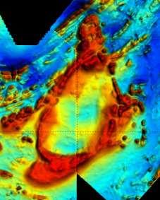
4 Magnetics as an Effective Mapping Tool

5 Aeromagnetic Expressions
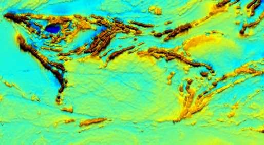
6 Aeromagnetic Expressions - 2


7 Digital Data Filters LOW PASS FILTERS Retain long wavelength, low frequencies = deep sources. E.g. Upward continuation. MEASURED DATA HIGH PASS FILTERS Retain short wavelength, high frequencies = shallow sources. E.g. 1VD, 2VD, downward continuation.


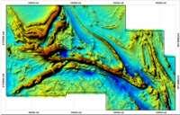
8 Typical Datasets Used TMI colordrape RTP1VD colordrape RTP1VD density sliced TMI intensity AS colordrape TILT density sliced Images Courtesy of Rainy River Resources Ltd.


9 The Need for Integrated Teams Geological interpretation of geophysical data in mineral exploration requires input from several disciplines, working together: Geophysics; Stratigraphy; Structural Geology; and Ore Deposits Geology Not dissimilar to long-standing exploration teams in the petroleum industry: Geophysics; Stratigraphy; Structural Geology; and Reservoir Engineer.
 lithologies. Direct targeting (magnetic signature associated with deposit): Kimberlites; BIF s; Some porphyries & skarns; Some IOCG s.")
10 Indirect versus Direct Targeting Indirect targeting (most common): Interpretation & structural analysis of magnetic data assists by: Highlighting suitable fluid conduits and traps; and Recognition / interpretation of favorable host (& source) lithologies. Direct targeting (magnetic signature associated with deposit): Kimberlites; BIF s; Some porphyries & skarns; Some IOCG s. Ernest Henry IOCG Cu-Au 122Mt 1%Cu 0.5g/t Au

11 Indirect Targeting Concept To define geological relationships that will: Increase understanding of the processes that control ore deposition within a target area; Reduce exploration risk by defining the constraints on ore distribution. Can include the following inputs: Structural distribution; Structural evolution; Lithological distribution; Stratigraphic relationships. Timing.
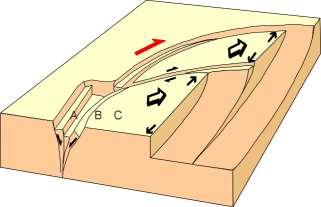
12 The Principles of Structural Control Permeability is unlikely to be the same everywhere on an active fault zone. Permeability will generally be highest where damage within and around the fault zone is highest. This will depend to some extent on host rock type, but will principally be localised by irregularities (e.g. bends, branches, steps, jogs) along the fault. Damage zones around irregularities along fault zone are zones of enhanced permeability


13 Applied Structural Control Principles Determine the direction and sense of movement on the faults, in order to predict the location, shape and plunge of zones of maximum damage / dilation. Zone of dilation associated with bend on sinistral fault

14 The Importance of Getting Timing Right Application of structural control principles requires that the timing of mineralisation must be carefully matched with the history of activity on a fault system. Regional cleavage cuts high-grade mineralization


15 The Importance of Getting Timing Right Our interpretations must capture timing in terms of deformation and mineralization. Red Lake
16 Interpretation Process


17 Interpretation - 1 Aeromagnetic interpretation should be broken down into three stages: OBSERVATION; COMPILATION; and INTERPRETATION. All of the principles of geological mapping and interpretation apply equally to aeromagnetic data; and Decide on the: Scale; Filters; Resolution achievable and the resolution required; and Time needed and time available.
18 Interpretation - 2 When relating lithology or stratigraphy to magnetics, think: Which rocks contain the magnetic minerals (field evidence, susceptibility measurements, petrology)? Do these rocks always contain magnetic minerals in this area? How and when did the magnetic minerals form? Be wary of making the following generalizations: The XYZ Formation is highly magnetic - Is it?? Always?? Everywhere?? Uniformly?? The igneous and metamorphic rocks will be more magnetic than the sedimentary rocks - They are frequently not!! The mafic rocks will be more magnetic than the felsic rocks - They are frequently not!! Think in terms of the magnetic rock body in the ground.not the magnetic field it causes. Formulation of structural history consistent with observations.
19 Interpretation Flowchart Extract line data from 1VD image Determine movement direction and dips on faults and dip direction of stratigraphy. Add data from other sources (radiometrics and gravity) annotate on a separate layer Extract Lithology data from TMI image. Divide area into major lithological packages. Interpret faults breaks, truncations etc. Annotate accordingly. Add exploration model parameters Add geological model parameters Add geological data from surface geology maps, drilling results identify formations and marker units Improve on unit boundaries, annotate and connect marker units from magnetics Finalize map presentation, prepare cross-sections and block model, check geology for internal consistency


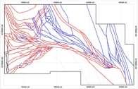
20 Method 1VD data Stratigraphic Form Line mapping Fault/deformation zone mapping (including timing) Fold mapping (including timing) Total Field data Lithology mapping Integrated interpretation


21 Geological Models for Mapping Geological models are a primary component of the interpretation process for producing maps; In order to present an interpretation of the geology of the region, there needs to be a coherent framework of stratigraphic and structural principles that form the basis of the interpretation; A coherent regional geological pattern can be followed through the series of maps; Individual structures can be interpreted in both a time and space context. We can interpret when and how faults moved; The spatial distribution of mineral deposits in relation to structures becomes evident, and can be related to the geological evolution of the region, not just the geometry; Areas and structures with potential for reactivation at later times become apparent; and Cross-sections can be developed which provide a realistic 3D form consistent with the geological models.

22 Apply Structural Models Incorporate structural reality; Based on modern analogues.


23 Fault Patterns in Athabasca Basin What is wrong with this interpretation? From Jefferson et al. 2007
: 2.699 Ga 2 Deformation: D 1 Northwest trending, south plunging F 1 folds 2.744 Ma-2.733 Ga 1 D 2 East to northeast trending F 2 folds ~2.")
24 Reviewing Geological History Stratigraphy: Balmer Mafic volcanism: Ga 1 Confederation Mafic-Intermediate volcanism: Ga 1 Granodiorite plutonism: Ga 1 Granodiorite dykes (Madsen, post-gold): Ga 2 Deformation: D 1 Northwest trending, south plunging F 1 folds Ma Ga 1 D 2 East to northeast trending F 2 folds ~2.720 Ga 1 (Coeval with Dome Stock) D 3 Coplanar with D 2 ~2.690 Ga 1 Metamorphism: Peak ~ Ga 1 Gold Madsen : Ga 2 Or Ga 3 Gold Red Lake, Campbell, Cochenour: and Ga 3 1 Sanborn-Barrie et al Geology, Red Lake greenstone belt, western Superior Province, Ontario. GSC Open File Dube et al A preliminary report on amphibolite facies, disseminated-replacement style mineralization at the Madsen gold mine, Red Lake, Ontario. GSC Current Research 2000-C17. 3 Dube et al Timing of gold mineralization at Red Lake, NW Ontario, Canada. New constraints from U-Pb geochronology at the Goldcorp High-Grade Zone, Red Lake Mine, and the Madsen mine. Economic Geology, V.99. Red Lake Age Data Map, Figure 3, Sanborn-Barrie et al


25 Structural Analysis - 1 What can you use it for? Provide regional framework for understanding of known mineralization & regions of unknown geology; Develop tectonic / metallogenic models; Predictive targeting (regional and prospect scale); Problem solving ( where d it go?? ); Attempt reconstruction of early tectonic settings; Comprehensive metallogenic targeting; and Engineering geology problems.
; Predictive targeting: Direct anomaly; Direct structural analogy; and Indirect structural targeting (new models?")
26 Structural Analysis 2 What can we get out of the data? Distribution of structures (folds / faults etc), lithologies & alteration - form surface mapping - extend from 2D plan view to 3D Kinematics? Relative timing? Development of tectonic models (local & regional); Predictive targeting: Direct anomaly; Direct structural analogy; and Indirect structural targeting (new models?); Extension of models outside immediate area to different areas or terranes.

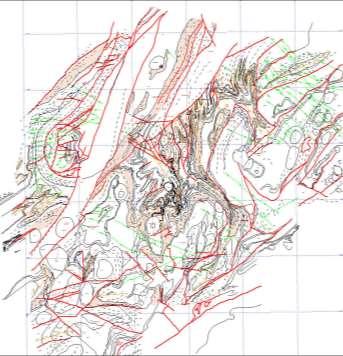
27 Structural Analysis 3 Key Questions: What structures occur? What is their extent? Relative geometry? What strain was produced? What P/T conditions did they form at? What is the 3D geometry? What was the tectonic driving force & history? What is the relationship of all this to mineralization? Ontario Superior/Grenville Compilation, 400m line spacing, RTP1VD. Wabigoon subprovince.
; Timing relationships: Fault - fault relationships; Displacement of marker units;")
28 Structural Analysis 4 Important Observations To Make: Map structural traces (geophysics, field data, maps, remote sensing); 3D - fault dips (field data, magnetic profiles); Fault displacement vectors: Relative displacements; Kinematic indicators; Associated structures (veins / R, R faults & fractures); Timing relationships: Fault - fault relationships; Displacement of marker units; Absolute dates. Fault characteristics: Thin, straight (brittle, shallow, low T); Broad zone with discrete breaks (brittle-ductile zone - mod P & T); or Broad zone, no breaks (ductile - deep, high T).
: Associated features: Folds (parallel / oblique); 2nd order sediments / basins; Associate intrusives / extrusives; Veining / alteration; and Recognition of fault hierarchy (1st order, 2nd order")
29 Structural Analysis 5 Important Observations To Make (cont.): Associated features: Folds (parallel / oblique); 2nd order sediments / basins; Associate intrusives / extrusives; Veining / alteration; and Recognition of fault hierarchy (1st order, 2nd order etc). Strain variations inferred from block geometries: Structures at block margins; and Strain within blocks (possible modified stress fields). Regional context: Relationship of area to regional structures; Setting (e.g. basin, mobile belt, arc etc.); Orogenic events elsewhere at inferred time of faulting? Pre-existing structures possibly reactivated?
30 Examples

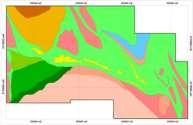
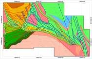
31 Example of Final Geological Maps

32 Final Geological Maps - Yilgarn The Yilgarn Craton in Western Australia - a Late Archean Granite-Greenstone terrane. Kambalda Ni deposits St. Ives Au deposit Junction Au deposit
33 Quest The Problem? Area is largely overlain by Quaternary cover.

34 Reviewing the Geological History...e.g. Quest Stratigraphy: Nicola Group (Southern Quesnel; Middle to Upper Triassic): Pyroxene, feldspar-pyroxene and feldspar phyric basalt breccias, volcaniclastic units and sandstone; Takla Group (Northern Quesnel; Middle to Upper Triassic): Augite-phyric and aphyric basalt breccia, agglomerate, tuff and flows; red fragmental basalt; tuffaceous argillite and siltite; conglomerate, sandstone, greywacke, siltstone and chert; local andesitic basalt; minor limestone and diorite; Cache Creek Complex (Lower Mississippian to Lower Jurassic): Mafic volcanic rocks, limestone, argillite, chert, serpentinite; Slide Mountain Group (Lower Mississippian to Middle Permian): Basalts and Mississippian chert-quartz sandstones and conglomerates Snowshoe Group: Quartzite, schist, phyllite, gneiss, marble, conglomerate; and Chilcotin Group (Oligocene to Pliocene): Columnar jointed olivine basalt. BCGS Geoscience map QUEST bedrock Logan et al.

35 Reviewing the Geological History...e.g. Quest Deformation: Subduction and accretion of intermontane terranes to Laurentia, ca. 200 Ma; Subduction and associated sinistral transpression with movement of Quesnel terrane northwards, ca. 185 Ma; Subduction and associated dextral transpression, ca. 100 Ma; and Dextral transtension and major dextral movement along the Denali- Tintina fault system, ca. 55 Ma. Monger, 2008
.")
36 Upper Triassic-Upper Jurassic Porphyries Pre- to syn- accretion; Early Calc-alkalic Cu-Mo (Au) porphyries; ~ Ma Alkalic Cu- Au porphyries; ~ 200 Ma Calc-alkalic Cu- Mo and Cu Au porphyries; Ma Alkalic Cu-Au porphyries; and S < 170 Calc-alkalic Cu-Mo- Au porphyries (Island Cu). Q Modified after Nelson and Colpron, 2007
37 Quest - Datasets GSC Aeromagnetic Data, RTF, 800 m line spacing GSC Aeromagnetic Data, 1VD, 800 m line spacing
38 Quest Form Line Mapping Quest Area Form Lines Quest Form Lines Vs. Mapped Geology
39 Quest Fault Mapping Quest Area Faults Quest Faults with GSC 1VD magnetic grid

40 Quest Mt. Polley Setting Mt. Polley occurs within a fault duplex, trending WNW relative to main NW trending faults % Cu, 0.29 g/t Au, 0.95 g/t Ag Mt.P Age: Ma Mt.P


41 Quest Mt. Polley Setting Mt.P Mt.P Split in Mt. Polley syenitemonzonite intrusion related to fault network Mt.P


42 Quest A Tectonic Model? Monger, 2008 MM Reverse-sinistral transpression creating WNW or E-W pull-apart structures Mt.P


43 The Way Forward Digitizing Unconstrained inversions from UBC software

 can be directly used to")
.")


44 The Way Forward Data Integration 3D Geophysical Inversion: Most gridded potential field data sets (magnetics, density or EM) can be directly used to constrain 3D geological models. (3D Geomodeller & GOCAD). 3D GIS: Spatial data analysis, domaining and querying. Unconstrained inversions from UBC software Structural Data: Wireframes created from planar measurements. Stereonets! field GoCad 1 drill hole 2 3
; Define your geological and structural history; and Incorporate multiple datasets, e.")
45 Conclusions To produce an accurate, applied geological interpretation: Think geologically process/controls when defining geological elements from aeromagnetic data; Focus your interpretation with an understanding of potential controls on the distribution of mineralization first; Incorporate reality structural settings/geometries, known geological relationships in the area (e.g. stratigraphic relationships); Define your geological and structural history; and Incorporate multiple datasets, e.g. existing geological mapping, drillhole data.
Geophysics as a Mapping Tool
 SOCIETY OF ECONOMIC GEOLOGY EXPLORATION IN 2025 TOOLS AND TECHNIQUES TO EXPLORE UNDER COVER Using Geophysical Data for Geological and Structural Mapping Jon Woodhead, Ph.D. Principal Geologist Condor Consulting
Geology of Quesnel and Stikine terranes and associated porphyry deposits. Jim Logan Paul Schiarizza
 Geology of Quesnel and Stikine terranes and associated porphyry deposits Jim Logan Paul Schiarizza Quesnel and Stikine terranes Major cordilleran terranes characterized by similar Late Triassic Early Jurassic
Geological & Geophysical Interpretation of ZTEM EM and Magnetic Survey. Kemess Project, BC. for AuRico Metals Inc. September, 2016 Nicole Pendrigh
 Geological & Geophysical Interpretation of ZTEM EM and Magnetic Survey Kemess Project, BC for AuRico Metals Inc. September, 2016 Nicole Pendrigh SUMMARY REPORT Regional setting Located in North central
Mine Scale Constrained Geophysical Inversion; A Case Study at the Darlot-Centenary Gold Mine
 Page 1 Mine Scale Constrained Geophysical Inversion; A Case Study at the Darlot-Centenary Gold Mine Sarah Monoury, SRK Consulting, Ben Jupp, SRK Consulting and Andrew Foley, Gold Fields This article was
Instituto De Ingenieros De Minas Del Peru
 The Continuity Challenge Dr. Wayne Barnett The Interpretation! Great geological continuity? Huge potential? The Reality Not what it might seem... Not what it might seem... Presentation Objective Highlight
EXISTING GEOLOGICAL INFORMATION
 CHAPER 3 EXISTING GEOLOGICAL INFORMATION 3-1 General Geology of the Surrounding Area (1) General geology and ore deposits in Mongolia Geographically, Mongolia is a country located between Russia to the
Regional GIS based exploration targeting studies in data poor environments
 Regional GIS based exploration targeting studies in data poor environments A case study of gold prospectivity mapping in Nigeria Matthew Greentree, Mathieu Lacorde and Bert De Waele Acknowledgements Australian
3. GEOLOGY. 3.1 Introduction. 3.2 Results and Discussion Regional Geology Surficial Geology Mine Study Area
 3. GEOLOGY 3.1 Introduction This chapter discusses the baseline study of the geology and mineralization characteristics of the mine study area. The study consolidates existing geological data and exploration
State Metallic Minerals Lease Sale Minnesota s Vermilion Gold District
 State Metallic Minerals Lease Sale Minnesota s Vermilion Gold District State Metallic Minerals Lease Sale Notice of Intent Scale 1:100,000 State Metallic Minerals Lease Sale This portion of the lease sale
Satulinmäki Au Prospect Structural Mapping
 M19/2024/2003/1/10 Juhani Ojala Satulinmäki Au Prospect Structural Mapping V. Juhani Ojala Geological Survey of Finland 1 Table of Contents Introduction...2 Local geology...2 Structures...2 Discussion...2
CSA Mine Observations Applied to the Development of Regional Exploration Models
 CSA Mine Observations Applied to the Development of Regional Exploration Models 1 Introduction Recent work completed by the geology team has resulted in an improved understanding of the CSA mine system
Answers: Internal Processes and Structures (Isostasy)
") Answers: Internal Processes and Structures (Isostasy) 1. Analyse the adjustment of the crust to changes in loads associated with volcanism, mountain building, erosion, and glaciation by using the concept
Answers: Internal Processes and Structures (Isostasy) 1. Analyse the adjustment of the crust to changes in loads associated with volcanism, mountain building, erosion, and glaciation by using the concept
QUALITATIVE INTERPRETATION OF POTENTIAL FIELD PROFILES: SOUTHERN NECHAKO BASIN
 QUALITATIVE INTERPRETATION OF POTENTIAL FIELD PROFILES: SOUTHERN NECHAKO BASIN By Melvyn E. Best Bemex Consulting International 5288 Cordova Bay Road Victoria, B.C. V8Y 2L4 KEYWORDS: potential fields,
twd$ yqsi+hca
 -t@~cl--t,i twd$ yqsi+hca C ASSESSMENT REPORT ON THE OR0 1-5 CLAIMS NEAR GOLDBRIDGE, B.C. Lillooet Mining Division N.T.S. 92 J / 15 W Long. 122 51.5 W. Lat. 50 47.5 N. Owned by Levon Resources Ltd. Optioned
JOSH LEIGH Project Exploration Geologist June ASX Code AIV
 COALSTOUN AND BOOUBYJAN Porphyry Copper-Gold Complexes, their structural setting, geology and geochemistry Joshua Leigh 1, Doug Young 2, Jose Veracruz 3, Paul Ashley 3 - ( 1 ActivEX Limited, 2 Consultant,
GREATLAND GOLD PLC (AIM:GGP) ERNEST GILES PROJECT - EASTERN YILGARN
 ERNEST GILES PROJECT - EASTERN YILGARN") GREATLAND GOLD PLC (AIM:GGP) ERNEST GILES PROJECT - EASTERN YILGARN Ownership Greatland Pty Ltd 100% Area 1,800 square kilometres Licences E38/2204 Calanchini Granted E38/2882 Carnegie Granted E38/3183
GREATLAND GOLD PLC (AIM:GGP) ERNEST GILES PROJECT - EASTERN YILGARN Ownership Greatland Pty Ltd 100% Area 1,800 square kilometres Licences E38/2204 Calanchini Granted E38/2882 Carnegie Granted E38/3183
GOLDCLIFF TULAMEEN PORPHYRY COPPER PROJECT COPPER MOUNTAIN CAMP, BRITISH COLUMBIA THE TROJAN-CONDOR COPPER TARGET HIGHLIGHTS
 Suite 350-885 Dunsmuir Street PF 250 764 8879 TF 866 769 4802 Vancouver, BC, Canada FX604 261 8994 info@goldcliff.com V6C 1N5 GCN.TSXV www.goldcliff.com GOLDCLIFF TULAMEEN PORPHYRY COPPER PROJECT COPPER
TECTONIC AND STRUCTURAL CONTROLS ON INTRUSION- RELATED DEPOSITS IN THE NORTHERN PART OF SREDNA GORA ZONE, BULGARIA NIKOLAY PETROV & KAMELIA NEDKOVA
 TECTONIC AND STRUCTURAL CONTROLS ON INTRUSION- RELATED DEPOSITS IN THE NORTHERN PART OF SREDNA GORA ZONE, BULGARIA NIKOLAY PETROV & KAMELIA NEDKOVA INVESTIGATED AREA Praveshka Lakavica deposit Elatsite
New gold discovery in the Paleoproterozoic Mauken greenstone belt
 New gold discovery in the Paleoproterozoic Mauken greenstone belt Mauken greenstone belt The Paleoproterozoic Mauken greenstone belt is situated in an unexplored and untested terrain in Northern Norway.
GEOLOGY OF THE NICOLA GROUP BETWEEN MISSEZULA LAKE AND ALLISON LAKE
 GEOLOGY OF THE NICOLA GROUP BETWEEN MISSEZULA LAKE AND ALLISON LAKE (92H/15E. 10E1 By V. A. Preto INTRODUCTION Mapping was continued southward from the area covered in 1973 and an additional 55 square
The Implications of the Mineral System Concept for Geophysical Exploration: A Perspective. Mike Dentith
 The Implications of the Mineral System Concept for Geophysical Exploration: A Perspective Mike Dentith michael.dentith@uwa.edu.au PDAC Toronto 2018 Traditional geophysical exploration strategy: Mapping
The Cobalt Rainbow. Airborne geophysical maps show that a north trending aeromagnetic high suggests further undiscovered mineralisation.
 The Cobalt Rainbow The property is located on Greenstone Creek, approximately 4.8 kilometres south west of the creek mouth. The property is located about 24 km due west of Campbell River, in the east-central
GEOLOGICAL INVESTIGATION IN THE ISLAND LAKE GREENSTONE BELT, NORTHWESTERN SUPERIOR PROVINCE, MANITOBA (PARTS OF NTS 53E/15 & 16) GS-18
 GS-18") GS-18 GEOLOGICAL INVESTIGATION IN THE ISLAND LAKE GREENSTONE BELT, NORTHWESTERN SUPERIOR PROVINCE, MANITOBA (PARTS OF NTS 53E/15 & 16) by S. Lin, H.D.M. Cameron, E.C. Syme and F. Corfu 1 Lin, S., Cameron,
GS-18 GEOLOGICAL INVESTIGATION IN THE ISLAND LAKE GREENSTONE BELT, NORTHWESTERN SUPERIOR PROVINCE, MANITOBA (PARTS OF NTS 53E/15 & 16) by S. Lin, H.D.M. Cameron, E.C. Syme and F. Corfu 1 Lin, S., Cameron,
Ramping-up Exploration Value from Aeromagnetic Surveys - More Geological Input Needed!
 Ramping-up Exploration Value from Aeromagnetic Surveys - More Geological Input Needed! Dave Isles Southern Geoscience Consultants AIG Geoscientists Symposia Bali May 2013 EAST ASIA: Geology, Exploration
Chapter 15 Structures
 Chapter 15 Structures Plummer/McGeary/Carlson (c) The McGraw-Hill Companies, Inc. TECTONIC FORCES AT WORK Stress & Strain Stress Strain Compressive stress Shortening strain Tensional stress stretching
The McPhillamys Gold Deposit, Discovery History & Geology. Presenter: Tara French
 The McPhillamys Gold Deposit, Discovery History & Geology. Presenter: Tara French Forward-Looking Statements This presentation contains forward-looking statements. without limitation: Estimates of future
Update on Chillagoe Mining District Research: Dec 7, 2017
 Update on Chillagoe Mining District Research: Dec 7, 2017 Peter Illig 1, Zhaoshan Chang 1 1 EGRU James Cook University, Townsville QLD 4811, Australia Introduction to Chillagoe Deposits Regional introduction
Azerbaijan International Mining Company Limited
 Updated Mineral Resources Gedabek Mineral Deposit, Republic of Azerbaijan Azerbaijan International Mining Company Limited Prepared by CAE Mining CAE Mining 8585 Cote-de-Liesse Saint-Laurent Quebec H4T
Drill locations for the 2015 program are highlighted in the geology map below.
 2015 Exploration Program The exploration program plan at KSM for 2015 was designed to improve the understanding of block cave targets and support engineering/environmental aspects of development scenarios.
Wind Mountain Project Summary Memo Feeder Program
 A Manex Resource Group Company Wind Mountain Project Summary Memo Feeder Program J.A. Kizis, Jr., February 07, 2018 Assays have been received for both holes drilled at Wind Mountain during late 2017 and
The Konongo Gold Project, Ghana: An Example of How Geology Makes All the Difference to a Resource Estimate
 The Konongo Gold Project, Ghana: An Example of How Geology Makes All the Difference to a Resource Estimate 1. Introduction 2. Geology Regional 3. Geology Project scale 4. Geology Mine scale 5. Approach
predictive mineral discovery*cooperative Research Centre A legacy for mineral exploration science Mineral Systems Q4 Fluid flow drivers & pathways
 Mineral Systems Q4 Fluid flow drivers & pathways 1 Key Parameter Mineral System Exploration is reflected in scale-dependent translation A. Gradient in hydraulic potential B. Permeability C. Solubility
High Resolution Seismic for Minerals
 High Resolution Seismic for Minerals Greg Turner HiSeis Pty Ltd MEGWA April 2013 WELCOME HiSeis Pty Ltd, Suite 4 Enterprise Unit 3, 9 DeLaeter Way, Bentley, WA 6102 Ph: +61 8 9470 9866 www.hiseis.com Used
ASX Announcement. 28 January Drill results indicate large Porphyry Copper Gold System at Peenam
 ASX Announcement 28 January 2010 Drill results indicate large Porphyry Copper Gold System at Peenam Highlights: 270 metres of visible copper (gold) mineralisation in first diamond core hole at Peenam Prospect
Queensland Mining Corporation Limited
 Queensland Mining Corporation Limited ABN 61 109 962 469 ASX Release 29 th July 2011 Drilling Commenced at Duck Creek Copper-Gold Project, Cloncurry, North-west Queensland Highlights RC drilling has commenced
Using 3D/4D modeling tools in exploration of gold-polymetallic potential areas in Greece
 Using 3D/4D modeling tools in exploration of gold-polymetallic potential areas in Greece Arvanitidis N.D., Michael C., Weihed P., Gaál l G., Royer J.J., Perantonis G., Bakalis V., Ballas D. and Christidis
Improvements on 2D modelling with 3D spatial data: Tin prospectivity of Khartoum, Queensland, Australia
 Improvements on 2D modelling with 3D spatial data: Tin prospectivity of Khartoum, Queensland, Australia C. E. Payne, F. W. Cunningham, A. J. Wilkins & G. A. Partington Kenex Ltd. Outline Prospectivity
Geomechanical Modelling of the Mount Isa Copper Deposit
 Geomechanical Modelling of the Mount Isa Copper Deposit John G McLellan 1, 2, Rhonda O Sullivan 3, Brad Miller 4, Daniel Taylor 5 1. Principal Geoscience Consultant, GMEX, John@gmex.com.au. 2. Adjunct
GEOPHYSICS GRAVITY DATA COVERAGE
 GEOPHYSICS DATA COVERAGE The Mudgee-Gulgong district lies within the Dubbo 1:250,000 sheet area. This area is now covered by high res_olution gravity, magnetic and radiometric data. The aeromagnetic and
Chapter 10: Deformation and Mountain Building. Fig. 10.1
 Chapter 10: Deformation and Mountain Building Fig. 10.1 OBJECTIVES Describe the processes of rock deformation and compare and contrast ductile and brittle behavior in rocks. Explain how strike and dip
Burchell Lake, A Copper, Gold and Molybdenum Property In Ontario. Corporate Presentation September, 2013
 Burchell Lake, A Copper, Gold and Molybdenum Property In Ontario Corporate Presentation September, 2013 Background Tanager Energy Inc. is a Canadian corporation whose shares are traded on the TSX Venture
Magmatic-Hydrothermal Gold Systems in the Archean of Northern Ontario, Canada: Examples of Syenite-Associated and Porphyry-Type Au-(Cu) Deposits
 Deposits") Magmatic-Hydrothermal Gold Systems in the Archean of Northern Ontario, Canada: Examples of Syenite-Associated and Porphyry-Type Au-(Cu) Deposits By Dr. Daniel J. Kontak Department of Earth Sciences Laurentian
Magmatic-Hydrothermal Gold Systems in the Archean of Northern Ontario, Canada: Examples of Syenite-Associated and Porphyry-Type Au-(Cu) Deposits By Dr. Daniel J. Kontak Department of Earth Sciences Laurentian
For personal use only
 VICTORIAN PORPHYRY COPPER GOLD TENEMENTS GRANTED ASX ANNOUNCEMENT 13 AUGUST 2013 Mantle Mining Corporation Limited (ASX: MNM) is pleased to report that three exploration licences highly prospective for
Anthill Resources Yukon - An Update on the Einarson Project
 Anthill Resources Yukon - An Update on the Einarson Project The Eastern Extension of a Carlin-type Gold Trend in the Selwyn Basin Anthill Resources Ltd Yukon Claim Holdings Over 2400 km 2 Property Location
Chapter 3. Geology & Tectonics
 Chapter 3 Geology & Tectonics 3.1 Geology The general geological features of Indonesia are shown in Figure 3.1. The basement formation is metamorphic and it is intruded with plutonic formations. They are
Bird River Belt in southeastern Manitoba: a Neoarchean volcanic arc in the Western Superior Province. Paul Gilbert Manitoba Geological Survey
 Bird River Belt in southeastern Manitoba: a Neoarchean volcanic arc in the Western Superior Province Paul Gilbert Manitoba Geological Survey Location of Bird River Belt Bird River Belt Winnipeg Bird River
Structural Evolution of the Keno Hill Ag-Pb-Zn mining district, Yukon
 Structural Evolution of the Keno Hill Ag-Pb-Zn mining district, Yukon Simon D. Craggs, David R. Lentz and Joseph C. White Introduction The Keno Hill Ag-Pb-Zn mining district is located in the central Yukon,
predictive mineral discovery*cooperative Research Centre A legacy for mineral exploration science Mineral Systems Q1 Architecture
 Mineral Systems Q1 Architecture 1 Key Parameter Mineral System Exploration is reflected in scale-dependent translation A. Gradient in hydraulic potential B. Permeability C. Solubility sensitivity to P,
Exploring in the last frontier: Skarn mineralisation, Attunga District, NSW
 BROVEY MAPPING SERVICES Exploring in the last frontier: Skarn mineralisation, Attunga District, NSW Latest exploration findings and interpretations Nancy Vickery, Joshua Leigh and Michael Oates Outline
"When Gregor Samsa woke up one morning from unsettling dreams, he found himself changed into a monstrous bug. Metamorphosis, by Franz Kafka
 Metamorphosis "When Gregor Samsa woke up one morning from unsettling dreams, he found himself changed into a monstrous bug. Metamorphosis, by Franz Kafka Metamorphism The transformation of rock by temperature
COPPERSTONE RESOURCES AB INTERCEPTS ZONE OF CHALCOPYRITE-ARSENOPYRITE- BORNITE MINERALIZATION AT SVARTLIDEN IN FIRST DEEP DRILLHOLE FROM 720m-810m
 COPPERSTONE RESOURCES AB INTERCEPTS ZONE OF CHALCOPYRITE-ARSENOPYRITE- BORNITE MINERALIZATION AT SVARTLIDEN IN FIRST DEEP DRILLHOLE FROM 720m-810m In mid-january 2017 Copperstone Resource published a geological
Golden Cross Resources
 Golden Cross Resources Labrador Uranium Joint Venture with Altius Resources Update - November 2007 Labrador Uranium - Canada LABRADOR URANIUM PROPERTIES Golden Cross Resources signed an agreement with
GEOLOGY AND GEOCHRONOLOGY OF THE ISLAND LAKE GREENSTONE BELT, NORTHWESTERN SUPERIOR PROVINCE by J. Parks 1, S. Lin 1, M.T. Corkery and D.W.
 GS-17 GEOLOGY AND GEOCHRONOLOGY OF THE ISLAND LAKE GREENSTONE BELT, NORTHWESTERN SUPERIOR PROVINCE by J. Parks 1, S. Lin 1, M.T. Corkery and D.W. Davis 2 Parks, J., Lin, S., Corkery, M.T. and Davis, D.W.
Exploration Update: RC Drilling Commenced at Lucky Strike
 L efroy ASX Announcement LEFROY EXPLORATION LIMITED Western Australian Focused Gold Explorer ASX Code: LEX Shares on Issue: 64.5m Current Share Price: 17c Market Capitalisation: $11m Board of Directors
The structure of the Mt Carlton Cu-Au deposit
 Dirks, P.H.G.M., The structure of the Mt Carlton Cu-Au deposit. SYMPOSIUM: New technologies and approaches in mineral exploration. FUTORES II, 4-7 June 2017, Townsville, Qld, Australia. 2017 The structure
Serengeti Resources Inc GEOCHEMICAL REPORT ON THE SHADOW PROPERTY a.
 Serengeti Resources Inc. 2004 GEOCHEMICAL REPORT ON THE SHADOW PROPERTY a. Located in the Johanson Lake Area Omenica Mining Division NTS 94D/9 6 degrees and 32 minutes North Latitude 126 degrees and 2
General Geology Lab #7: Geologic Time & Relative Dating
 General Geology 89.101 Name: General Geology Lab #7: Geologic Time & Relative Dating Purpose: To use relative dating techniques to interpret geological cross sections. Procedure: Today we will be interpreting
Copper and Zinc Production, Disciplined Growth. S I T E V I S I T O C T O B E R % Owned Projects
 Copper and Zinc Production, Disciplined Growth. S I T E V I S I T O C T O B E R 2 0 1 6 100% Owned Projects Serbia assets Timok Magmatic Complex Rakita Joint Venture 4 exploration permits in the Bor region,
Summary of Rover Metals Geologic Mapping Program at the Up Town Gold Project, Northwest Territories
 October 13, 2017 Summary of Rover Metals Geologic Mapping Program at the Up Town Gold Project, Northwest Territories Vancouver, British Columbia, Canada - Rover Metals Corp., Rover, is pleased to provide
Report of Activities 2003 Published by: Manitoba Industry, Economic Development and Mines Manitoba Geological Survey, 2003.
 Report of Activities 2003 Published by: Manitoba Industry, Economic Development and Mines Manitoba Geological Survey, 2003. ERRATA: The publisher/department name in the bibliographic reference cited immediately
Mineral potential mapping it works! Phillip Blevin SMEDG Meeting, Sydney 22 November 2018
 Mineral potential mapping it works! Phillip Blevin SMEDG Meeting, Sydney 22 November 2018 Department of Planning and Environment Contents 1. Why mineral potential studies? 2. Which mineral systems? 3.
Structural geology and gold metallogeny of the New Britannia mine area, Snow Lake, Manitoba
 Structural geology and gold metallogeny of the New Britannia mine area, Snow Lake, Manitoba Chris Beaumont-Smith Manitoba Geological Survey Boundary zone New Britannia Trans-Hudson Orogen 50 km 100 km
Mountain Maid Gold System Displays Major Size Potential
 29 July 2008 The Manager, Companies Australian Securities Exchange Ltd Electronic Announcement System Dear Sir, AXIOM MINING LIMITED (ASX CODE: AVQ) ASX Announcement Mountain Maid Gold System Displays
Detour West Gold Project Technical Overview. April, 2018
 Detour West Gold Project Technical Overview April, 2018 Detour West Project Overview Detour West is a 7,680 hectare property located at the northwest margin of the Abitibi Greenstone Belt, 20 km west of
MINERAL DEPOSITS OF THE COBAR BASIN
 MINERAL DEPOSITS OF THE COBAR BASIN 360 hard rock deposits in Cobar Basin Cu, Au, Ag, Pb, Zn combinations and quartz-au veins Cobar 23 major deposits in Cobar Basin World class Endeavor mine World class
Redbank Granted IOCG Prospective Tenements in Gawler Craton, SA
 ASX ANNOUNCEMENT 7 NOVEMBER 2018 Redbank Granted IOCG Prospective Tenements in Gawler Craton, SA HIGHLIGHTS 2018 Project Generation activities for Redbank identified highly prospective Olympic Dam-style
JV Project Portfolio Executive Summary: Bruce Smith
 JV Project Portfolio Executive Summary: Bruce Smith September 5, 2012 Disclaimer Forward-Looking Statements This presentation contains forward-looking statements, including but not limited to comments
Archean Terranes. Archean Rocks. Southeastern Africa. West Greenland. Kaapvaal Craton. Ancient Gneiss Complex
 Archean Terranes Archean Rocks Chapter 15A >2.5 Gy old Younger supracrustal sequences Greenstone belts Calc-alkaline metavolcanic rocks Older gneiss complexes Quartzo-feldspathic rocks Tonalites and migmatites
Advancing High Grade Gold Assets in Red Lake, Ontario
 Advancing High Grade Gold Assets in Red Lake, Ontario Forward Looking Statement Except for historical information contained herein, this presentation may contain forward-looking statements including but
R.Suhasini., Assistant Professor Page 1
 UNIT I PHYSICAL GEOLOGY Geology in civil engineering branches of geology structure of earth and its composition weathering of rocks scale of weathering soils - landforms and processes associated with river,
Chapter 10. Chapter Rocks and the Rock Cycle. Rocks. Section 1 Rocks and the Rock Cycle
 Chapter 10 Rocks 1 Chapter 10 Section 1 Rocks and the Rock Cycle 2 10.1 Rocks and the Rock Cycle Magma is the parent material for all rocks. Once the magma cools and hardens, many changes can occur. Geology:
Topics Laramide Orogeny: Late Cretaceous to Early Eocene Reading: GSA DNAG volume 3, Ch. 6
 Topics Laramide Orogeny: Late Cretaceous to Early Eocene Reading: GSA DNAG volume 3, Ch. 6 Late Cretaceous to early Eocene New patterns developed 5 main regions Tectonic interpretations Post-Laramide events
Uncovering The Riches of the Abitibi Greenstone Belt of Canada
 1 TSX.V: ALZ June 2016 Uncovering The Riches of the Abitibi Greenstone Belt of Canada The Haultain Gold Discovery The Abitibi Greenstone Belt & Gold 170+ million oz of gold produced to date from more than
A review of the large Red Dragon prospect was completed following the 2011 field season, the
 ASX / MEDIA RELEASE ST GEORGE MINING LIMITED ASX: SGQ ACN 139 308 973 Level 1, 115 Cambridge Street PO Box 1305, West Leederville WA 6007 www.stgeorgemining.com.au Phone +618 9322 6600 Facsimile +618 9322
Introduction. Introduction. Introduction 10/15/2014. The Agents of Metamorphism. Metamorphism. and Metamorphic Rocks
 Introduction Metamorphism The transformation of rocks, usually beneath Earth's surface, as the result of heat, pressure, and/or fluid activity, produces metamorphic rocks Metamorphism and Metamorphic Rocks
Gidji Lake formation -
 Gidji Lake formation - Key Stratigraphic marker for World Class Gold Deposits of Kalgoorlie Presentation to CSIRO - July 2017 Please reference this document if the slides, figures or concepts are to be
New geologic mapping + and associated economic potential on northern Hall Peninsula, Baffin Island, Nunavut
 New geologic mapping + and associated economic potential on northern Hall Peninsula, Baffin Island, Nunavut Holly Steenkamp, M.Sc. Regional Mapping Geoscientist David Mate, M.Sc. Chief Geologist November
DÉCOUVERTE Positioned for Discovery in James Bay, Quebec. Investor Presentation, January 2018 by Danae Voormeij, MSc, PGeo
 DÉCOUVERTE Positioned for Discovery in James Bay, Quebec Investor Presentation, January 2018 by Danae Voormeij, MSc, PGeo Location Maps and Infrastructure Location: Durango Resources 100% owned Découverte
Practice Test Rocks and Minerals. Name. Page 1
 Name Practice Test Rocks and Minerals 1. Which rock would be the best source of the mineral garnet? A) basalt B) limestone C) schist D) slate 2. Which mineral is mined for its iron content? A) hematite
CEE 437 Lecture 10 Rock Classification. Thomas Doe
 CEE 437 Lecture 10 Rock Classification Thomas Doe Igneous Origins Intrusive Batholithic or plutonic: phaneritic Dikes or sills that chill rapidly: aphanitic Extrusive deposition as melt (lava) pyroclastic
ASX Announcement. New economic gold results confirm Dave East as an exciting new discovery. Highlights. 4 July 2011
 4 July 2011 ASX Announcement New economic gold results confirm Dave East as an exciting new discovery Level 2, 9 Colin Street West Perth WA 6005 ABN 11 127 171 877 p (08) 9216 1000 f (08) 9481 7939 w www.predictivediscovery.com
Mineral Systems and Exploration Targeting. T. Campbell McCuaig - Centre for Exploration Targeting
 Mineral Systems and Exploration Targeting T. Campbell McCuaig - Centre for Exploration Targeting Mineral Geoscience Masters October 2013 Premise Exploration is an exercise in sequential volume reduction,
Structural Geology of D-pit at Akara Mining, Pichit Province, North Central Thailand
 Research Article Structural Geology of D-pit at Akara Mining, Pichit Province, North Central Thailand Chalermpol Jamduong and Pitsanupong Kanjanapayont* Department of Geology, Faculty of Science, Chulalongkorn
Magnus Copper Project exploration update
 ASX ANNOUNCEMENT 30 SEPTEMBER 2011 CODE: ALY BOARD OF DIRECTORS Mr Warwick Davies Non-Executive Chairman Mr Robert Brierley Managing Director Mr John Arbuckle Non-Executive Director Mr Jeffrey Moore Non-Executive
predictive iscovery Why is the gold where it is? redictive mineral ineral discovery pmd CRC
 The Y2 project (2001-2004) Time-space evolution of the Yilgarn Craton: implications for geodynamics Kevin Cassidy and the Y2 team Reduced D Risk through Improved Targeting ineral d Why is the gold where
BCGold Corp. Discovery Driven
 BCGold Corp. Discovery Driven Sickle-Sofia Property Copper-Gold Porphyry Discovery in the Toodoggone Camp! Cautionary Statement This presentation does not constitute an offer to sell or solicitation of
7 Sedimentation and tectonics at a mid- Ordovician to Silurian active margin
 80 Mountain Building in Scotland 7 Sedimentation and tectonics at a mid- Ordovician to Silurian active margin 7.1 Introduction In mid-ordovician to Silurian times, the Grampian mountains underwent exhumation,
Linking structure & mineralisation in Laverton, with specific reference to Sunrise Dam & Wallaby John Miller
 Linking structure & mineralisation in Laverton, with specific reference to Sunrise Dam & Wallaby John Miller Centre for Exploration Targeting University of Western Australia W Swager (1997) regional D
Lands Parcels in IOL CO-20
 Lands Parcels in IOL CO-20 1 CO-20 The Izok Corridor Lupin - multi-million ounce past gold production (3.6 million oz of gold at average grade of 9.3 g/t Au) Approximately 1 million ounces of undeveloped
Mishi Lake Gold Property Mishibishu Lake Area, Wawa
 Mishi Lake Gold Property Mishibishu Lake Area, Wawa Location, Accessibility, Infrastructure and Local Resources The property is located 40 km west of Wawa, Ontario, in the Mishibishu Lake Area, Sault Ste.
Prospectivity Modelling of Granite-Related Nickel Deposits Throughout Eastern Australia
 Prospectivity Modelling of Granite-Related Nickel Deposits Throughout Eastern Australia M P Hill 1 and A McCarthy 2 ABSTRACT Spatial modelling has been used to determine potential locations of granite-related
East Kambalda (Aztec Dome) Review & IM (Sale Document)
 Review & IM (Sale Document)") ASX Announcement 3 December 2013 ABN: 45 116 153 514 ASX: TMX East Kambalda (Aztec Dome) Review & IM (Sale Document) East Kambalda (Aztec Dome) Review & IM (Sale Document) As part of Terrain Minerals Ltd
ASX Announcement 3 December 2013 ABN: 45 116 153 514 ASX: TMX East Kambalda (Aztec Dome) Review & IM (Sale Document) East Kambalda (Aztec Dome) Review & IM (Sale Document) As part of Terrain Minerals Ltd
Pacific Northwest Rock Lab, Part II. Igneous Rocks. Name Per.
 Name Per. Pacific Northwest Rock Lab, Part II After you ve classified all your rocks, place their numbers next to the names and read the information about the rock. Check the classifications here (igneous,
NEWS RELEASE FOR IMMEDIATE RELEASE: MARCH 5, 2018
 NEWS RELEASE FOR IMMEDIATE RELEASE: MARCH 5, 2018 Eskay Mining provides update on ongoing geological review - Targeting E&L-Type Nickel-Copper-PGE and Eskay-Type VMS Potential on Its Golden Triangle Holdings:
Beekeeper Property The Geology South of Mint Lake. Cariboo Mining Division
 Beekeeper Property The Geology South of Mint Lake NTS: 93A/6 Cariboo Mining Division Claims: Beekeeper 1 #I2055 Beekeeper 2 #3892 Beekeeper 3 #7895 Beekeeper 4 #8503 Latitude: Longitude: 52 degrees 24
Quaternary clays alluvial sands of the Shepparton Formation overlie the basement rocks.
 NAGAMBIE GOLDFIELD Regional Geological Setting The Nagambie Project is located within the Melbourne Structural Zone of Victoria. The lithologies range in age from the Upper Silurian Broadford Formation
Page 1. Name: 1) Which diagram best shows the grain size of some common sedimentary rocks?
 Which diagram best shows the grain size of some common sedimentary rocks?") Name: 1) Which diagram best shows the grain size of some common sedimentary rocks? 1663-1 - Page 1 5) The flowchart below illustrates the change from melted rock to basalt. 2) Which processes most likely
Name: 1) Which diagram best shows the grain size of some common sedimentary rocks? 1663-1 - Page 1 5) The flowchart below illustrates the change from melted rock to basalt. 2) Which processes most likely
Chapter 8 10/19/2012. Introduction. Metamorphism. and Metamorphic Rocks. Introduction. Introduction. The Agents of Metamorphism
 Chapter 8 Metamorphism Introduction Metamorphism - The transformation of rocks, usually beneath Earth's surface, as the result of heat, pressure, and/or fluid activity, produces metamorphic rocks During
1. are most likely to study the images sent back from Mars. A. Astronomers B. Geologists C. Doctors D. Engineers
 1. are most likely to study the images sent back from Mars. A. Astronomers B. Geologists C. Doctors D. Engineers 2. When did the Earth form? A. About 540 million years ago B. About 2.5 billion years ago
A New Direction. Copper-Gold Deposit at Thor TSX.V:COL. August 11, May 2013
 A New Direction Copper-Gold Deposit at Thor August 11, 2016 May 2013 TSX.V:COL FORWARD LOOKING STATEMENTS This presentation includes certain forward-looking information or forward-looking statements for