MINING PLAN WITH PROGRESSIVE MINE CLOSURE PLAN
|
|
|
- Stephany Beasley
- 6 years ago
- Views:
Transcription

 AGREEMENT PERIOD 5.0 YEARS PLAN PERIOD 5.")
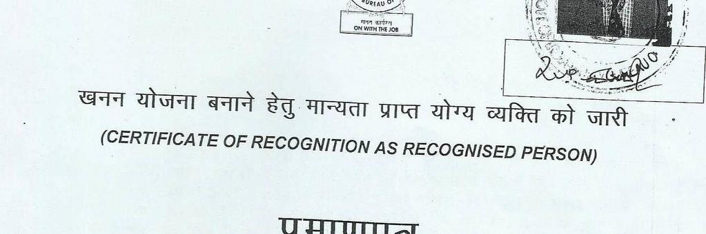
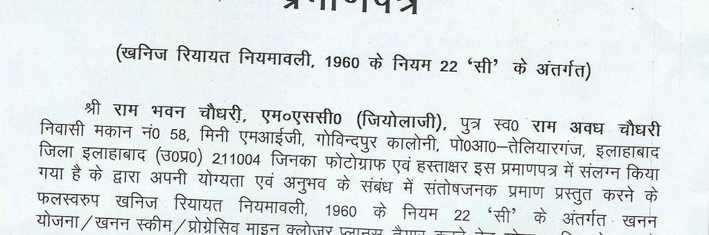
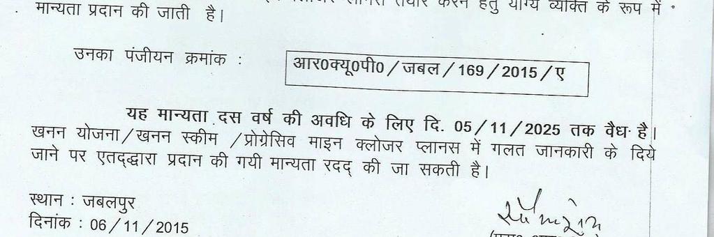
1 MINING PLAN WITH PROGRESSIVE MINE CLOSURE PLAN For M/s R & S Associates Village Palpur, Post Dandupur, Tehsil Karchhana, District - Allahabad, Uttar Pradesh Brick Earth Mining from Khasra/Gata Nos. 317, 320, 324, 326, 466, 327, 328, 350, 352, at Village Palpur, Tehsil Karchhana, District - Allahabad, Uttar Pradesh Area ha ( Acres) AGREEMENT PERIOD 5.0 YEARS PLAN PERIOD 5.0 YEARS APPLICANT/LESSEE: Sri Anil Kumar Singh S/o Sri Rajendra Singh R/o Village Palpur, Tehsil Karchhana, District - Allahabad, Uttar Pradesh PREPARED BY R B Chaudhary: RQP/JABAL/169/2015/A chaurb@gmail.com
2 AUTHORISATION LETTER BY THE PROPONENT I Anil Kumar Singh S/o Sri Rajendra Singh R/o Village Palpur, Tehsil Karchhana, District - Allahabad, Uttar Pradesh hereby authorized Sri R. B. Chaudhary, RQP/JABAL/169/2015/Ato prepare the Mining Plan with Mine Closer Plan under rule 34(2) of amended rules of U.P. Minor Mineral Concession Rule 1963 and 1M, PFR & CSR Plan and presentation before DEAC in respect of proposed earth extraction which to be used in Brick Kiln of M/s R & S Associates from Khasra/Gata Nos. 317, 320, 324, 326, 466, 327, 328, 350, 352, Area ha ( Acres) at Village Palpur, Tehsil Karchhana, District - Allahabad, Uttar Pradesh. I hereby solemnly affirm that all the information & documents given by me are true to the best of my knowledge and belief. I, request, the Director, Directorate of Geology & Mining, Lucknow to make further correspondence regarding modification and to collect the approved copies of the aforesaid Scheme of Mining, the said recognized person on his following address. Sri R. B. Chaudhary 58 Mini MIG Govindpur Allahabad Phone RQP/JABAL/169/2015/A Place-Lucknow Date:.. Anil Kumar Singh S/o Sri Rajendra Singh R/o Village Palpur, Tehsil Karchhana, District - Allahabad, Uttar Pradesh

3
4 Mine Plan INTRODUCTION Bricks are produced in India in small or cottage scale brick kilns and Clamps, operates seasonally. The raw materials in the brick kilns include topsoil, coal, paddy husk, fly ash, wood & locally available agro wastes to some extent. There are large variations in quality of soils available in different parts of the country and also in brick manufacturing process. Brick are good building material for construction activities. It is one of the primary building materials known to mankind. Over time, bricks have appeared, gained prominence, lost importance and then come to the forefront again with various styles of architecture. Burnt bricks were used in ancient Indian, Babylon, Egypt and Roman civilizations. With the increase of urbanization the demand for Bricks is growing in infrastructure sector in our country. Individual and private companies are increasingly demanding Brick for construction purposes and this has immense pressure on brick clay resources. This increasing demand and extraction makes this an environmental issue. As per Environment (Protection) Rules, 1986, vide S.O. 141(E), dated 15th Jan, 2016,) the applicant is seeking prior environmental clearance, Therefore applicant has submitted for mine plan for proposed earth extraction which to be used in Brick Kiln of M/s R & S Associates from Khasra/Gata Nos. 317, 320, 324, 326, 466, 327, 328, 350, 352, Area ha ( Acres) at Village Palpur, Tehsil Karchhana, District - Allahabad, Uttar Pradesh. The applicant grants conditional agreement from different farmers which is enclosed as Annexure1. Hence, This Mining Plan including Progressive Mine Closer Plan is being submitted under rule 34 (2) of U.P. Minor Mineral (concession) Rules The authorization to prepare Mining Plan including progressive mine closer plan by applicant is enclosed. 1.0 GENERAL: A) Sri Anil Kumar Singh S/o Sri Rajendra Singh R/o Village Palpur, Tehsil Karchhana, District - Allahabad, Uttar Pradesh. B) Status of Applicant: Private /Partnership C) Mineral, occurring in the area & which Applicant Intends To Mine: Soil mining (extraction) which used in Brick Kiln D) Period of mining lease: As per agreement from farmer and self affidavit enclosed as Annexure 1 E) Name of R.Q.P. preparing the mining plans: Name Sri R. B. Chaudhary Page 1 of 10
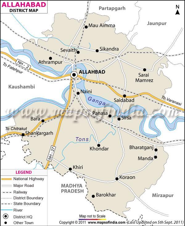
5 Mine Plan F) Name of prospecting agency: The lease area is prospected by lessee under the guidance of Sri R. B. Chaudhary (RQP). Address - 58 Mini MIG Govindpur Allahabad Phone Registration No: RQP/JABAL/169/2015/A G) Reference no & date of consent letter from the State Govt. 2.0 LOCATION AND ACCESSIBILITY A) Details of area (with location map) Proposed earth extraction which to be used in Brick Kiln of M/s R & S Associates from Khasra/Gata Nos. 317, 320, 324, 326, 466, 327, 328, 350, 352, Area ha ( Acres) at Village Palpur, Tehsil Karchhana, District - Allahabad, Uttar Pradesh. B) Whether the area is recorded to be in forest (please specify whether protected, reserved etc.): The Agreement area is free from forest land. C) Ownership/Occupancy: Total lease area is completely outside of any restricted or protected area declared by any state or central government. D) Existence of public road /railway line, if any nearby and approximate distance: Soil miming area is located at Vi Village Palpur, Tehsil Karchhana, District - Allahabad, Uttar Pradesh, Which is connected to NH-27 about 0.9 Km (E), NH-76 about 6.0 Km (E), Karma Road 6.34 Km (S), Jamoli Road 4.80 Km (E) from excavation site and nearest Airport is Allahabad Airport 14.0 km (NW) away from the area. Location Map on Plate No 1. E) Toposheet No. with latitude and longitude: Toposheet /Google Map the boundary points have been demarcated with the help of GPS as per revenue/ khasra map & coordinates of all the gata. Table No 1 Co-ordinates of excavation Gata Khasra/ Gata Nos Latitude Longitude '2.17"N 81 49'24.06"E '1.47"N 81 49'23.08"E '0.88"N 81 49'23.64"E '1.24"N 81 49'21.85"E '0.26"N 81 49'22.39"E '0.42"N 81 49'21.43"E '0.70"N 81 49'20.04"E '0.04"N 81 49'20.67"E '59.67"N 81 49'21.89"E Page 2 of 10
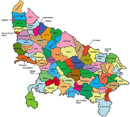
6 Mine Plan 3.0 GEOLOGY AND EXPLORATION: a) Briefly describe the topography & general geology & local mine geology of the mineral deposit including draining pattern. 3.1 TOPOGRAPHY & PHYSIOGRAPHY Agricultural plain Allahabad city, also known as Prayag, is an ancient holy city of India. The city of Allahabad is situated at the confluence of two sacred rivers, the Yamuna and the Ganges. The confluence is known as Sangam and is visited by thousands of Hindu pilgrims every year. Allahabad is among the largest cities of Uttar Pradesh in terms of population and area. The geographical area of Allahabad is about 62 sq km (under Municipal Corporation). Its spatial extension falls at N latitude and E longitude. The district of Allahabad is surrounded by the Pratapgarh districts in the North, district Jaunpur in the Northeast, Sant Ravidas Nagar and Mirjapur in the east, Kaushambi and Chitrakoot in the west and the state of Madhya Pradesh in the South. Allahabad has its own domestic airport, Bambruali, which is located 14 km from the city. Apart from Indian Airlines, few private airlines also provide flight services to and from Allahabad. However, nearby cities, i.e. Varanasi (147 km) and Lucknow (210 km) also have airports. Allahabad is well connected by a network of trains to almost all major destinations throughout the country i.e. Kolkata, Delhi, Patna, Guwahati, Chennai, Mumbai, Gwalior, Meerut, Lucknow, Kanpur and Varanasi. Allahabad is located on National Highways 2 and 27. The government and private bus services are available to and from Allahabad to all nearby major destinations. 3.2 GEOLOGY Regional Geology: The Ganga basin has been dominated by transvers river system since Pliocene due to erosion during uplift that is symmetric subsidence of foreland. Large plio-pleistocene sediment combines with less asymmetric subsidence and uplift of the proximal fore land let to the pro gradation of the drainage system that displaced the Yamuna River and after Allahabad Ganga River to edge of the foreland basin. The Present river system consistent with erosion driven uplift adjacent Himalayan. The regional geological setup is very well depicted in the map below; Page 3 of 10
7 Mine Plan Source: Singh I B 1996 Table: Geological Succession Land Form Period Age Rock Type (Geomorphology) Upper Pleistocene to New Alluvium Fine Sand And Clays Recent QUATERNARY Lower Pleistocene Sand of different grades and Older Alluvium to Upper Pleistocene clay mixed with kankar UNCONFORMITY Vindhyan Sandstone (Proterozoic) UNCONFORMITY Bundelkhand Granitr (Archean) Local Geology: Geology map of Allahabad city shows the existence of Terrace Alluvium and Varanasi Alluvium as geologic unit. The Varanasi Older Alluvium, a polycyclic sequence of yellowish brown clay- silt and fine sand with dissemination of kankar, is exposed in the north of Yamuna. The Newer Alluvium is characterized by unoxidised khaki and grey coloured sediments which consists predominantly of micaceous sand, silt and clay. It has been divided into Terrace and Channel Alluvium. The Terrace Alluvium of both Ganga and Yamuna are developed on a cut and eroded platform of Varanasi Older Alluvium. The Terrace Alluvium of Ganga consists of multiple fill sequence of grayish sand, silt and clay while that of Yamuna consists of medium to fine grained quartzo- feldspathic and grey micaceous sand. Geology of the area is characterized by a thick pile of quaternary Alluvium consisting of sand, grave land clay with occasional presence of thin to thick kankar intercalation. Page 4 of 10
8 Mine Plan 4.0 MINEABLE RESERVE: It shall be opencast semi mechanised mine involves scooping the mineral through use of hand implements like spade, pick axe, shovel and crowbar (JCB will be used if required) etc. In future top soil shall be scrapped by means manually and shall be used for the purpose of making bundwall and rehabilitation/reclamation. Method of estimation of reserves: Geological Reserve: Area (sqm) Depth (m) Mineable Reserve: Geological Reserve (Volume left in berm (cum) + Volume of top soil (cum)) Volume of top soil: Area (sqm) Area of berm left (sqm) Thickness of top soil (m3) Mining shall be carried out from top to downward through the formation of benches. The height & width of benches shall be kept 1.0 m & 1.0 m with face slope. District Allahabad Village Palpur Gata No Area (ha) Table No 2 Land Details Name of Land owner Mohid Ali, Smt Mariyam Bibi, Nizamuddin, Mohd Hashim, Hazaratunnishan, Anil Kumar Singh Vijay Bahadur, Gulab, Sumesh Kumar, Udaybhan, Abish kumar, Sunil Kumar, Smt Pankali, Mahesh, Mangala, Sunil Patel, Akash Patel, Smt Sonkali, Suresh, Rajesh, Santosh, Smt Tani Devi Consent of the owner Sri Anil Kumar Singh Consent given for the Period (Year) Consent given for the depth of mining (m) Bhailal Ramtirath, Rammurat, Smt Bittan devi Ashok Kumar Smt Gyanwati, Rajendra Singh, Ajay Kumar Singh, Mohd Ahmad Total Area Page 5 of 10
9 Mine Plan Gata No Table No 3 Geological Reserves Gata No Area(ha) depth of Geological Reserve Area(m2) mining (cum) Total Geological Reserve Area of berm left (m2) Table No 4 Minable Reserves Volume left in berm (m3) Thickness of top soil (m3) Volume of top soil(total area-area in berm) * thickness of top soil (cum) Minable Reserves (m3) Total DETAILS OF EXPLOITATION: Year Wise Production Year Production Production (Cum) (Tonnes) First Second Third Fourth Fifth Total As per Brick Kiln capacity yearly production of bricks are lacs bricks/ season for that the required volume of brick clay will be brick in one cubic meter. Page 6 of 10
10 Mine Plan B) Attach supporting composite plan & section showing pit layout, dumps, stacks of sub grade mineral, if any etc: All quantities of brick-earth to be generated shall be used for the purpose of making brick except top soil. Therefore no proposal of separate stacking of brick-earth has been envisaged. All quantities of brick earth to be exploited shall be used for making brick. Top soil shall be kept on bundwall which will spread out after the completion of mining. C) Indicate proposed rate of production when the mine is fully developed & the expected life of mine & the year from which effected. As per Brick Kiln capacity yearly production of bricks are lacs bricks/ season for that the required volume of brick clay will be brick in one cubic meter. D) Conceptual Plan: The lease area is small & during plan period cum shall be explored. Remaining reserve will be exploration in next mining plan and agreement period if any. The ultimate shape of pit by the end of conceptual period shall be same as the shape of area except bundwall. E) Waste Management Top soil exists within the area therefore its Preserved on bundwall and use in reclamation propose. F) Reclamation/Rehabilitation: The mined out area & reclamation / rehabilitation as on date, at the end of plan period & at the end of conceptual period Top soil shall be kept on bundwall which will spread out after the completion of mining. 5.0 BLASTING: As mentioned earlier there is simple Alluvium (soil) mining, mined mineral will be used f or brick making.therefore blasting not proposed/required. 6.0 MINE DRAINAGE: One dug well is situated near by area. The top level of the well is 98 mrl & water table encountered in the well is about m. deep 7.0 DISPOSAL OF WASTE All quantities of brick earth to be generated shall be used for the purpose of making brick except top soil. Therefore no proposal of separate stacking of brick earth has been envisaged. All quantities of brick earth to be exploited shall be used for making brick. Page 7 of 10
11 Mine Plan 8.0 USE OF MINERAL: The brick earth below top soil in the agreement area is soft, medium to light in color alluvium typically found in the Indo-gangetic plane. After removal of top soil, the excavated brick earth will be used for making the brick (simple earth brick). 9.0 OTHER& SITE SERVICES The following site services will be provided at mine site 1. Office 2. Drinking water shed 3. Rest shelter 4. First Aid Centre 10.0 MINERAL PROCESSING The entire area consists of soil form & it is ready to making brick, no beneficiation of mineral processing will required. No Mineral beneficiation is involved within the lease area ENVIRONMENTAL MANAGEMENT PLAN: Attach a note on the status of base line information with regard to the following: I) Land Use: The existing land use of the area is almost agricultural waste lands. II) Water Regime: There is no perennial water body in the area. Water table loses its significance in this region due to great depth. The depth of water table is about m. below: general ground level. (III) Flora and Fauna: Vegetation and wild life are quite scanty. Trees of Neem, Jamun, Mango, Babul etc. are found only in and around the villages or in agriculture fields. Cows, donkeys, goats, sheep and buffalows are kept for house hold requirements. Wild life comprises of rabbits, Squirrels, foxes, snakes, and lizard. Fishes, turtle, and crabs form aquatic life which occurs within a radius of 5 km. No wild life is found within the lease area. (IV) Quality of ambient air noise level and water: The proposed site is located in the remote area having a clean atmosphere. Therefore the quality of ambient air will be as good Climatic data Page 8 of 10
12 Mine Plan The study area is Allahabad Plateau zone and is subjected to vagaries of weather. The climate of the project area is characterized by cool and dry climate. The year can be divided into three distinct seasons; winters last from October to March followed by summers from April to June. Temperature rom February there is rapid increase in temperature, May is the hottest month with the mean daily maximum temperature is 41.5 C and mean daily minimum temperature 26 C. After the onset of the monsoon there is appreciable drop in temperature, January is the coldest month with mean daily maximum temperature is C and mean daily minimum temperature is 9.3 C. The mean monthly maximum temperature is C and mean monthly minimum temperature is Humidity The relative humidity is high during the southwest monsoon season, with mean monthly morning relative humidity at 63.92% and mean monthly evening relative humidity at 48%. Cloudiness In the winter season the sky is generally clear or lightly clouded except for brief spells of a day or two each time when in association with the passage of western disturbances particularly in the northern parts of the district sky become cloudy. Sky is clear or lightly clouded in the summer and post-monsoon seasons. Heavily clouded to overcast sky prevail in the monsoon seas. Winds Winds are generally high with some increase in force during summer and southwest monsoon season. The mean wind velocity is 5.16 Km/hr and the potential evapo-transpiration rate is mm. Rainfall The main rainy season is the southwest monsoon season, from about the last week of June to September-mid, some rainfall much less in amount occurs in the cold season from December to February in association with the passage of western disturbances, The average annual rainfall is 934 mm. Climate is sub humid and is characterized by hot summer and pleasant monsoon and cold season. About 90% of rainfall takes place from June to September. During monsoon surplus water is available for deep percolation to ground water HUMAN SETTLEMENT& EMPLOYMENTS POTENTIAL The details of population, number of households, land, literacy etc. within a radius of 5 km. Human settlements are distributed in fringes of buffer zone. The inhabitants belong to all the four castes. The Page 9 of 10
13 Mine Plan main occupation in 5 km. buffer zone is farming and mining. Poor literacy conditions prevail in the surrounding of lease area & condition of literacy is more pathetic in females. Older generation wear Dhoti Kurta while younger generation is adopting dresses like pant, shirts etc SOCIOECONOMIC BENEFICIATE OUT OF MINING: The scale of operation is limited with 90% local employment. Hence some benefit to the local community will occur on this aspect. Besides the direct employment, indirect employment will include tractor owners, truck drivers, shop keepers dhaba walas etc Year wise no of saplings to be planted is as below: Along the approach roads and in the nearby villages i.e. with consultation the Gram Panchayats The tree species recommended are Ficus religosa (peepal), Shorea robusta (Sal) may also be recommended. Mangifera indica (Aam), Emb lica officinalis (Anwala), Aegle marmerlos (Ibei), Planting should be done in large sized 90 cm x 90 cm. due in advance and filled about 50 days before planting. The plantation raised earlier should be carefully maintained. Mortalities should be replaced by fresh planting. Page 10 of 10
14 Progressive Mine Closure Plan PROGRESSIVE MINE CLOSURE PLAN Name of Brick Kiln: M/s R & S Associates A) Name & address of applicants Sri Anil Kumar Singh S/o Sri Rajendra Singh R/o Village Palpur, Tehsil Karchhana, District - Allahabad, Uttar Pradesh. B) Location: Soil miming area is located at Vi Village Palpur, Tehsil Karchhana, District - Allahabad, Uttar Pradesh, Which is connected to NH-27 about 0.9 Km (E), NH-76 about 6.0 Km (E), Karma Road 6.34 Km (S), Jamoli Road 4.80 Km (E) from excavation site and nearest Airport is Allahabad Airport 14.0 km (NW) away from the area. Location Map on Plate No 1. Proposed Method of Mining: The proposed project is to mine Brick Clay from plot (s) under agreement sustainably and scientifically. Mining will be opencast and manual using hand tools only in the allotted plots keeping the nearby plot (s) unaffected. Following geo-scientific methods are proposed to carry out the activity. Mining will be confined to extraction of Brick Clay in its existing form from the allotted plot(s) only. Mining of Brick Clay from the allotted plot(s) will be restricted to a maximum depth of 2.0 m from the surface in proper bench form as per MCR-1960 and MMR The width and height of bench will be 1.0 m x 1.0 m. Topsoil up to 6 depth will be preserved to spread it after mining activity is completed to restore the fertility of land. Reasons for Closure: At present there is no foreseeable reason regarding closure of mine. The progressive mine closure plan is being submitted, under amended rule under Rule 34 (6) & (7) of amended rules of U. P. Minor Mineral (Concession) Rules 1963 Closure plan preparation: A) Name and address of the Applicant Sri Anil Kumar Singh S/o Sri Rajendra Singh R/o Village Palpur, Tehsil Karchhana, District - Allahabad, Uttar Pradesh. B) Name, address & Registration No. of R. Q. P. The lease area is prospected by lessee under the guidance of. Sri R. B. Chaudhary (RQP). Address - 56 Mini MIG Govindpur Allahabad Phone Page 1 of 6
15 Progressive Mine Closure Plan Registration No: RQP/JABAL/169/2015/A Mine Description: Topography: Agricultural plain Allahabad city, also known as Prayag, is an ancient holy city of India. The city of Allahabad is situated at the confluence of two sacred rivers, the Yamuna and the Ganges. The confluence is known as Sangam and is visited by thousands of Hindu pilgrims every year. Allahabad is among the largest cities of Uttar Pradesh in terms of population and area. The geographical area of Allahabad is about 62 sq km (under Municipal Corporation). Its spatial extension falls at N latitude and E longitude. The district of Allahabad is surrounded by the Pratapgarh districts in the North, district Jaunpur in the Northeast, Sant Ravidas Nagar and Mirjapur in the east, Kaushambi and Chitrakoot in the west and the state of Madhya Pradesh in the South. Allahabad has its own domestic airport, Bambruali, which is located 14 km from the city. Apart from Indian Airlines, few private airlines also provide flight services to and from Allahabad. However, nearby cities, i.e. Varanasi (147 km) and Lucknow (210 km) also have airports. Allahabad is well connected by a network of trains to almost all major destinations throughout the country i.e. Kolkata, Delhi, Patna, Guwahati, Chennai, Mumbai, Gwalior, Meerut, Lucknow, Kanpur and Varanasi. Allahabad is located on National Highways 2 and 27. The government and private bus services are available to and from Allahabad to all nearby major destinations. Geology: Regional Geology: The Ganga basin has been dominated by transvers river system since Pliocene due to erosion during uplift that is symmetric subsidence of foreland. Large plio-pleistocene sediment combines with less asymmetric subsidence and uplift of the proximal fore land let to the pro gradation of the drainage system that displaced the Yamuna River and after Allahabad Ganga River to edge of the foreland basin. The Present river system consistent with erosion driven uplift adjacent Himalayan. The regional geological setup is very well depicted in the map below; Page 2 of 6
16 Progressive Mine Closure Plan Source: Singh I B 1996 Table: Geological Succession Land Form Period Age Rock Type (Geomorphology) Upper Pleistocene New Alluvium Fine Sand And Clays to Recent QUATERNARY Lower Pleistocene Sand of different grades and to Upper Older Alluvium clay mixed with kankar Pleistocene UNCONFORMITY Vindhyan Sandstone (Proterozoic) UNCONFORMITY Bundelkhand Granitr (Archean) Local Geology: Geology map of Allahabad city shows the existence of Terrace Alluvium and Varanasi Alluvium as geologic unit. The Varanasi Older Alluvium, a polycyclic sequence of yellowish brown clay- silt and fine sand with dissemination of kankar, is exposed in the north of Yamuna. The Newer Alluvium is characterized by unoxidised khaki and grey coloured sediments which consists predominantly of micaceous sand, silt and clay. It has been divided into Terrace and Channel Alluvium. The Terrace Alluvium of both Ganga and Yamuna are developed on a cut and eroded platform of Varanasi Older Alluvium. The Terrace Alluvium of Ganga consists of multiple fill sequence of grayish sand, silt and clay while that of Yamuna consists of medium to fine grained quartzo- feldspathic and grey micaceous sand. Geology of the area is characterized by a thick pile of quaternary Alluvium consisting of sand, gravel and clay with occasional presence of thin to thick kankar intercalation. Page 3 of 6
17 Progressive Mine Closure Plan MINEABLE RESERVE: It shall be opencast semi mechanised mine involves scooping the mineral through use of hand implements like spade, pick axe, shovel and crowbar (JCB will be used if required) etc. In future top soil shall be scrapped by means manually and shall be used for the purpose of making bundwall and rehabilitation/reclamation. Method of estimation of reserves: Geological Reserve: Area (sqm) Depth (m) Mineable Reserve: Geological Reserve (Volume left in berm (cum) + Volume of top soil (cum)) Volume of top soil: Area (sqm) Area of berm left (sqm) Thickness of top soil (m3) Mining shall be carried out from top to downward through the formation of benches. The height & width of benches shall be kept 1.0 m & 1.0 m with face slope. District Allahabad Village Palpur Gata No Area (ha) Table No 2 Land Details Name of Land owner Mohid Ali, Smt Mariyam Bibi, Nizamuddin, Mohd Hashim, Hazaratunnishan, Anil Kumar Singh Vijay Bahadur, Gulab, Sumesh Kumar, Udaybhan, Abish kumar, Sunil Kumar, Smt Pankali, Mahesh, Mangala, Sunil Patel, Akash Patel, Smt Sonkali, Suresh, Rajesh, Santosh, Smt Tani Devi Consent of the owner Sri Anil Kumar Singh Consent given for the Period (Year) Consent given for the depth of mining (m) Bhailal Ramtirath, Rammurat, Smt Bittan devi Ashok Kumar Smt Gyanwati, Rajendra Singh, Ajay Kumar Singh, Mohd Ahmad Total Area Page 4 of 6
18 Progressive Mine Closure Plan Gata No Table No 3 Geological Reserves Gata No Area(ha) depth of Geological Reserve Area(m2) mining (cum) Total Geological Reserve Area of berm left (m2) Table No 4 Minable Reserves Volume left in berm (m3) Thickness of top soil (m3) Volume of top soil(total area-area in berm) * thickness of top soil (cum) Minable Reserves (m3) Total DETAILS OF EXPLOITATION: Year Wise Production Year Production Production (Cum) (Tonnes) First Second Third Fourth Fifth Total As per Brick Kiln capacity yearly production of bricks are lacs bricks/ season for that the required volume of brick clay will be brick in one cubic meter. Page 5 of 6
19 Progressive Mine Closure Plan Closure Plan: Mined out land: The mining has been proposed in already degraded land. Mining faces will advance from middle of the area towards north-east & south- west directions. The height and width of benches will be kept 1.0 m to 1.0 m, slope of mining faces will be kept 70 deg. and the overall slope of the pit will be kept 45 deg. No waste shall be generated, as all the ROM will be used as for brick making. Hence the reclamation will be done only on mature benches by planting local species after the bench reaches to its maturity. Top Soil Management: Top soil exists within the area therefore its Preserved on bundwall and use in reclamation propose. Safety and Security: Each worker shall be provided with helmets & safety shoes. Safety belt shall be provided to workers on working the top benches. Hanging of loose boulders shall be removed from mine faces. The mining area shall be properly fenced to avoid any inadvertent entry in to mining pit. Working hours shall be displaced at conspicuous places. Disaster Management and risk assessment: The mining will go up to a depth of 2.0 meter max. from the surface in the respective year and thereafter excavated area shall be left open during monsoon to restore the topography of the area. The mining faces shall be dressed properly because loose material may create fatal accidents to the labourers while working in area. Any other information: Community Development: The expensed increased towards the socio-economic development is done by proponent time to time. Page 6 of 6

20 Location Map Plate No. 1

21 Google Map Fig: 500 m Radius Map

22 Google Map Fig: 5.0 Km Radius Map
23
24
25
MINING PLAN WITH PROGRESSIVE MINE CLOSURE PLAN. M/s Uttam Brick Field
 MINING PLAN WITH PROGRESSIVE MINE CLOSURE PLAN For M/s Uttam Brick Field Roodi Ka Pura, Gohri, Soraon, Allahabad Brick Earth Mining from Khasra/Gata Nos. 466, 467, 1352, 517, 1130, 1179, 1601, 1605, 2273,
To, The Director, Directorate of Geology & Mining Uttar Pradesh, Lucknow
 To, The Director, Directorate of Geology & Mining Uttar Pradesh, Lucknow Date:./ /2017 Sub: Proposed earth extraction which to be used in brick kiln of M/s Shimla Singh Construction Company of Shri Dinesh
Encl:- Two copies of Mining Plan with Progressive Mine Closer Plan.
 To, The Director, Directorate of Geology & Mining Uttar Pradesh, Lucknow Date:./ /2016 Sub: Proposed earth extraction which to be used in Brick Kiln of M/s Vijay Ent Udyog from Khasra/Gata Nos. 248 ka,
Prakash Ent Udyog of Shri Jai Prakash Maurya S/o Shri Balram Maurya R/o :Village- Dighauta, Tehsil Handiya, District - Allahabad, Uttar Pradesh.
 To, The Director, Directorate of Geology & Mining Uttar Pradesh, Lucknow Date:./ /2017 Sub: Sub: Environmental clearance for brick earth mining for brick kiln of M/s Jai Prakash Ent Udyog of Shri Jai Prakash
TABLE OF CONTENTS. 1.0 Introduction. 2.0 Geology, Exploration and Reserves. 3.0 Mining. 4.0 Blasting. 5.0 Mine Drainage. 6.
 TABLE OF CONTENTS 1.0 Introduction 2.0 Geology, Exploration and Reserves 3.0 Mining 4.0 Blasting 5.0 Mine Drainage 6.0 Site Services 1.0 INTRODUCTION Pankaj Chandrakar a resident oftemri, P.O. Deopuri
PRE FEASIBILITY REPORT. Quartz and Feldspar Sy No 119 & 126/3, Kambampadu Village A. Konduru Mandal, Krishna District, Andhra Pradesh
 PRE FEASIBILITY REPORT Of Quartz and Feldspar Sy No 119 & 126/3, Kambampadu Village A. Konduru Mandal, Krishna District, Andhra Pradesh Area of Mining Lease 2.720 Ha For 1, 09,055.08 MT/Annum OF Quartz
MCDR INSPECTION General. Date of Inspection Name of the Mine Bhatbhera Limestone Mine 2 Total Lease Area (Ha)
") ::1:: MCDR INSPECTION General SN Particulars Details Date of Inspection 23.8.2015 1 Name of the Mine Bhatbhera Limestone Mine 2 Total Lease Area (Ha) 4.808 Hect (Govt. Revenue Land), Non-forest land with
::1:: MCDR INSPECTION General SN Particulars Details Date of Inspection 23.8.2015 1 Name of the Mine Bhatbhera Limestone Mine 2 Total Lease Area (Ha) 4.808 Hect (Govt. Revenue Land), Non-forest land with
AUTHORISATION LETTER BY THE LESSEE
 AUTHORISATION LETTER BY THE LESSEE I, Pankaj Kumar Tripathi, (Prop. of M/s Anushri Associate) hereby authorise to Shri Pankaj Pande RQP No. RPQ/DDN/086/95A to prepare the Mining Plan Under Amended Rule
Kurnool vide Proceedings No. 712/Q1/2012 dated Ulindakonda Village, Kallur Mandal, Kurnool District,
 1.0 EXECUTIVE SUMMARY 1.1 Introduction The proposed mining area of 1.157Ha. in survey No. 291 of Ulindakonda Village, Kallur Mandal, Kurnool District has been leased to M/s.Sri Lakshmi Sreenivasa Stone
FOR Sand Stone Quarry Village : Chhirraleva Tehsil : Basna District : Mahasamund
 Project Report FOR Sand Stone Quarry at Village : Chhirraleva Tehsil : Basna District : Mahasamund Contents 1. About the Firm... 1 2. Location of the Project... 1 3. Environmental Setting of Project...
PRE - FEASIBILITY REPORT Shri Santosh Kumar Dwivedi S/o Shri Goverdhan Dwivedi R/o Village Adampur Saibasi Majre
 1. EXECUTIVE SUMMARY PRE - FEASIBILITY REPORT Shri Santosh Kumar Dwivedi S/o Shri Goverdhan Dwivedi R/o Village Adampur Saibasi Majre Sarkandi, Tehsil and District - Fatehpur, Uttar Pradesh is the lessee
MCDR INSPECTION REPORT
 MCDR INSPECTION REPORT General S. N. Particulars Details 1 Name of the Mine Matia Limestone Mine 2 Total Lease Area (Ha) with breakup of Non-forest and forest 12.137 Ha. land 3 Mine code 38CHG14086 4 IBM
JAI MAA SHARDA STONE CRUSHING
 JAI MAA SHARDA STONE CRUSHING Prop. Hukum Singh (M. No. 9425585252) Near-Pahunadukan Kedarpur Ambikapur, (C.G.) To, The Member Secretary, SLEIAA(State Level Environment Impact Assessment Authority), Ministry
MCDR INSPECTION REPORT. S. N. Particulars Details 1 Name of the Mine, Inspecting officer with Designation, Date of Inspection
 MCDR INSPECTION REPORT General S. N. Particulars Details 1 Name of the Mine, Inspecting officer with Designation, Date of Inspection Bharuadih Limestone Mine,Rajesh Kumar Das,Sr.ACOM,18.08.2017 2 Total
MCDR INSPECTION REPORT
 MCDR INSPECTION REPORT General S. N. Particulars Details 1 Name of the Mine Matia Limestone Mine 2 Total Lease Area (Ha) with breakup of Non-forest and forest 8.144 ha.,non forest land land 3 Mine code
ANNEXURE-I (AS PER FORMAT ISSUED BY BIHAR-SEIAA)
") ANNEXURE-I (AS PER FORMAT ISSUED BY BIHAR-SEIAA) ANNEXURE-II (AS PER FORMAT ISSUED BY BIHAR-SEIAA) ANNEXURE-III LETTER OF INTENT Scanned by CamScanner Scanned by CamScanner Scanned by CamScanner
ANNEXURE-I (AS PER FORMAT ISSUED BY BIHAR-SEIAA) ANNEXURE-II (AS PER FORMAT ISSUED BY BIHAR-SEIAA) ANNEXURE-III LETTER OF INTENT Scanned by CamScanner Scanned by CamScanner Scanned by CamScanner
Report for Area Drainage Studies for 1320 MW (2x660 MW) THERMAL POWER PROJECT AT MIRZAPUR, U.P.
 THERMAL POWER PROJECT AT MIRZAPUR, U.P.") Report for Area Drainage Studies for 1320 MW (2x660 MW) THERMAL POWER PROJECT AT MIRZAPUR, U.P. 1. Introduction M/s Welspun Energy Uttar Pradesh Ltd. (WEUPL) is putting up 1320 MW (2 x 660 MW) coal fired
Report for Area Drainage Studies for 1320 MW (2x660 MW) THERMAL POWER PROJECT AT MIRZAPUR, U.P. 1. Introduction M/s Welspun Energy Uttar Pradesh Ltd. (WEUPL) is putting up 1320 MW (2 x 660 MW) coal fired
INDIAN BUREAU OF MINES MINERALS DEVELOPMEMT AND REGULATION DIVISION MCDR INSPECTION REPORT. Chennai regional office
 1. Mine file No : (i) Name of the Inspecting : Officer and ID No. INDIAN BUREAU OF MINES MINERALS DEVELOPMEMT AND REGULATION DIVISION TN/TCR/LST-1, MDS (ii) Designation : (iii) Accompaning mine : Official
SITE SELECTION CRITERIA FOR A SOLAR PV PLANT. Under The Guidence of SOHEL PATEL
 SITE SELECTION CRITERIA FOR A SOLAR PV PLANT Under The Guidence of SOHEL PATEL CONTENTS Introduction Selection of land 1.area longitude & latitude 2.quality of soil 3.soil test report 4.Terrain & contours
Submitted to: Central Coalfields Limited Ranchi, Jharkhand. Ashoka & Piparwar OCPs, CCL
 Land Restoration / Reclamation Monitoring of more than 5 million cu. m. (Coal + OB) Capacity Open Cast Coal Mines of Central Coalfields Limited Based on Satellite Data for the Year 2013 Ashoka & Piparwar
Study of Hydrometeorology in a Hard Rock Terrain, Kadirischist Belt Area, Anantapur District, Andhra Pradesh
 Open Journal of Geology, 2012, 2, 294-300 http://dx.doi.org/10.4236/ojg.2012.24028 Published Online October 2012 (http://www.scirp.org/journal/ojg) Study of Hydrometeorology in a Hard Rock Terrain, Kadirischist
MINING PLAN FORMAT (A & B CATEGORY MINES) As per MCDR,1988
 As per MCDR,1988") MINING PLAN FORMAT (A & B CATEGORY MINES) As per MCDR,988 INTRODUCTORY NOTES. 'A' category mines : all mines excluding 'B' Category mines. B' category mines : all 'B' Category mines excluding very small
MINING PLAN FORMAT (A & B CATEGORY MINES) As per MCDR,988 INTRODUCTORY NOTES. 'A' category mines : all mines excluding 'B' Category mines. B' category mines : all 'B' Category mines excluding very small
Analysis of Rainfall and Other Weather Parameters under Climatic Variability of Parbhani ( )
") International Journal of Current Microbiology and Applied Sciences ISSN: 2319-7706 Volume 7 Number 06 (2018) Journal homepage: http://www.ijcmas.com Original Research Article https://doi.org/10.20546/ijcmas.2018.706.295
International Journal of Current Microbiology and Applied Sciences ISSN: 2319-7706 Volume 7 Number 06 (2018) Journal homepage: http://www.ijcmas.com Original Research Article https://doi.org/10.20546/ijcmas.2018.706.295
Woodford County Erosion Prevention Plan and Permit. Application #
 Woodford County Erosion Prevention Plan and Permit Application # Date Instructions: Applicant will complete Parts A and B, and attach a proposed site diagram. This diagram must be completed in accordance
THE MINISTRY OF ENERGY AND ENERGY INDUSTRIES MINERALS DIVISION MINE DESIGN TEMPLATE OPERATOR NAME: OPERATOR ADDRESS: PHONE NUMBER: FACSIMILE:
 THE MINISTRY OF ENERGY AND ENERGY INDUSTRIES MINERALS DIVISION MINE DESIGN TEMPLATE 1.0 GENERAL INFORMATION OPERATOR NAME: OPERATOR ADDRESS: PHONE NUMBER: FACSIMILE: NAME OF CONTACT: CELLULAR PHONE: EMAIL
3. HYDROMETEROLOGY. 3.1 Introduction. 3.2 Hydro-meteorological Aspect. 3.3 Rain Gauge Stations
 3. HYDROMETEROLOGY 3.1 Introduction Hydrometeorology is a branch of meteorology and hydrology that studies the transfer of water and energy between the land surface and the lower atmosphere. Detailed hydrological
INDIAN BUREAU OF MINES MINERALS DEVELOPMEMT AND REGULATION DIVISION MCDR inspection REPORT Jabalpur regional office
 INDIAN BUREAU OF MINES MINERALS DEVELOPMEMT AND REGULATION DIVISION MCDR inspection REPORT Jabalpur regional office Mine file No : MP/KTN/LST-96 (i) Name of the Inspecting : Officer and ID No. (ii) Designation
MCDR INSPECTION REPORT
 MCDR INSPECTION REPORT 1.0 GENERAL SN Particulars Details 1 Name of the inspecting officer J.S. Hada, AMG 2 Date of Inspection 9.9.2017 3 Accompanying mine official Lessee and Mining Engineer Shri K.L.
Central Queensland Coal Project Appendix 4b Geotechnical Assessment. Environmental Impact Statement
 Central Queensland Coal Project Appendix 4b Geotechnical Assessment Environmental Impact Statement GEOTECHNICAL ASSESSMENT OF OPEN CUT MINING ADJACENT TO THE BRUCE HIGHWAY, CENTRAL QUEENSLAND COAL PROJECT
Land subsidence due to groundwater withdrawal in Hanoi, Vietnam
 Land Subsidence (Proceedings of the Fifth International Symposium on Land Subsidence, The Hague, October 1995). 1AHS Publ. no. 234, 1995. 55 Land subsidence due to groundwater withdrawal in Hanoi, Vietnam
FOREST RESEARCH INSTITUTE, DEHRADUN
 PROJECT REPORT DRAINAGE AND REPLENISHMENT STUDY OF MINED AREA OF GANGA SHYAMPUR RIVER HARIDWAR Submitted to UTTARAKHAND FOREST DEVELOPMENT CORPORATION (UFDC) 73, Nehru Road, Deharadun Prepared&Submitted
GROUNDWATER CONFIGURATION IN THE UPPER CATCHMENT OF MEGHADRIGEDDA RESERVOIR, VISAKHAPATNAM DISTRICT, ANDHRA PRADESH
 GROUNDWATER CONFIGURATION IN THE UPPER CATCHMENT OF MEGHADRIGEDDA RESERVOIR, VISAKHAPATNAM DISTRICT, ANDHRA PRADESH Prof.P.Jagadeesara Rao Department of Geo-Engineering and Centre for Remote Sensing, College
FORM -1 MINING PLAN & PRE-FEASIBILITY REPORT
 FORM -1 MINING PLAN & PRE-FEASIBILITY REPORT TO OBTAIN ENVIRONMENTAL CLEARANCE FOR QUARRYING OF ROUGH STONE (Extent 1.91.5Ha)-B2 Project IN S.F.No 1257/1 Village Nagamangalam Taluk Denkanikottai District
Advanced Hydrology. (Web course)
") Advanced Hydrology (Web course) Subhankar Karmakar Assistant Professor Centre for Environmental Science and Engineering (CESE) Indian Institute of Technology Bombay Powai, Mumbai 400 076 Email: skarmakar@iitb.ac.in
Advanced Hydrology (Web course) Subhankar Karmakar Assistant Professor Centre for Environmental Science and Engineering (CESE) Indian Institute of Technology Bombay Powai, Mumbai 400 076 Email: skarmakar@iitb.ac.in
A Review of Concept of Peri-urban Area & Its Identification
 A Review of Concept of Peri-urban Area & Its Identification Ar. Manita Saxena Research Scholar Department of Architecture and Planning M.A.N.I.T, Bhopal Dr. Supriya Vyas Assistant Professor, Department
UNIT 11 SOUTH ASIA SG 1 - PHYSICAL GEOGRAPHY & THE ENVIRONMENT
 UNIT 11 SOUTH ASIA SG 1 - PHYSICAL GEOGRAPHY & THE ENVIRONMENT I. PHYSICAL GEOGRAPHY TAKE OUT YOUR PHYSICAL MAP OF SOUTH ASIA A. The Himalayan Mountains form the northern boundary of the region (color
Geography Class XI Fundamentals of Physical Geography Section A Total Periods : 140 Total Marks : 70. Periods Topic Subject Matter Geographical Skills
 Geography Class XI Fundamentals of Physical Geography Section A Total Periods : 140 Total Marks : 70 Sr. No. 01 Periods Topic Subject Matter Geographical Skills Nature and Scope Definition, nature, i)
Paper presented in the Annual Meeting of Association of American Geographers, Las Vegas, USA, March 2009 ABSTRACT
 Paper presented in the Annual Meeting of Association of American Geographers, Las Vegas, USA, March 2009 ABSTRACT CHANGING GEOMORPHOLOGY OF THE KOSI RIVER SYSTEM IN THE INDIAN SUBCONTINENT Nupur Bose,
FOR QUARRYING OF KAGANAM ROUGH STONE AND GRAVEL QUARRY
 PROPOSAL TO OBTAIN ENVIRONMENTAL CLEARANCE FROM District Level Environment Impact Assessment Authority (DEIAA), Tiruvannamalai District, Tamilnadu FOR QUARRYING OF KAGANAM ROUGH STONE AND GRAVEL QUARRY
STUDY AREA AND METHODOLOGY
 . CHAPTER 2 STUDY AREA AND METHODOLOGY 26 CHAPTER 2 STUDY AREA AND METHODOLOGY Kundalika is a major river in konkan region of Maharashtra. River originates in Western Ghats at an altitude of 820 m ASL
ANNEXURE I Site Location map of M/s. Stone Plus quarry lease A-1
 ANNEXURE I Site Location map of M/s. quarry lease A-1 Quarry Lease boundary map of M/s. A-2 a. Introduction M/s. proposes to conduct semi mechanized open cast method quarrying for Colour granite extraction
KANSAS GEOLOGICAL SURVEY Open File Report LAND SUBSIDENCE KIOWA COUNTY, KANSAS. May 2, 2007
 KANSAS GEOLOGICAL SURVEY Open File Report 2007-22 LAND SUBSIDENCE KIOWA COUNTY, KANSAS Prepared by Michael T. Dealy L.G., Manager, Wichita Operations SITE LOCATION The site was approximately four miles
International Journal of Modern Trends in Engineering and Research e-issn No.: , Date: April, 2016
 International Journal of Modern Trends in Engineering and Research www.ijmter.com e-issn No.:2349-9745, Date: 28-30 April, 2016 Landslide Hazard Management Maps for Settlements in Yelwandi River Basin,
Summary and Conclusions
 241 Chapter 10 Summary and Conclusions Kerala is situated in the southern tip of India between 8 15 N and 12 50 N latitude and 74 50 E and 77 30 E longitude. It is popularly known as Gods own country.
ICSE Board Class X Geography Board Paper- 2014
 Time:2 hrs ICSE Board Class X Geography Board Paper- 2014 Total Marks: 80 General Instructions: 1. Answers to this paper must be written on the paper provided separately. 2. You will not be allowed to
A Study on Storm Water Drainage System of Annanagara and Ashokanagara of Shimoga City Karnataka India
 A Study on Storm Water Drainage System of Annanagara and Ashokanagara of Shimoga City Karnataka India Veena D Savanth Lecturer, Department of Civil Engineering Jain Institute of Technology, Davanagere,
Figure 2.1: Constituent Area
 2 The Region 2.1 CONSTITUENT AREA The National Capital Region includes NCT-Delhi, nine districts of Haryana, six districts of Uttar Pradesh and one district of Rajasthan. Total area of the region is 34,144
Limestone Deposit of Nimbahera area of Chittorgarh District (Raj.)
") Limestone Deposit of Nimbahera area of Chittorgarh District (Raj.) Presented by - Mr. Deepak Kalla & Mr. Rajneesh Kothari Date of Presentation - 07/10/2017 Place of Presentation G.M.D.C. Auditorium Ahemdabad
Limestone Deposit of Nimbahera area of Chittorgarh District (Raj.) Presented by - Mr. Deepak Kalla & Mr. Rajneesh Kothari Date of Presentation - 07/10/2017 Place of Presentation G.M.D.C. Auditorium Ahemdabad
The Impact of Geography in South and East Asia
 The Impact of Geography in South and East Asia Gobi desert, Mongolia Essential Question: How does the geography of SE Asia impact trade and the distribution of population throughout the region? (AKS #52a)
Flood hazard mapping in Urban Council limit, Vavuniya District, Sri Lanka- A GIS approach
 International Research Journal of Environment Sciences E-ISSN 2319 1414 Flood hazard mapping in Urban Council limit, Vavuniya District, Sri Lanka- A GIS approach Abstract M.S.R. Akther* and G. Tharani
Request for Empanelment
 Request for Empanelment (Empanelment is method/procedure/way to seek technical & financial or financial quotation from eligible firm/organization/academic institute to short list eligible contender for
Geographical location and climatic condition of the
 Geographical location and climatic condition of the study sites North eastern region of India is comprised of eight states namely; Arunachal Pradesh, Assam, Manipur, Meghalaya, Mizoram, Nagaland, Sikkim
The Impact of Geography in South and East Asia
 The Impact of Geography in South and East Asia Gobi desert, Mongolia Essential Question: How does the geography of SE Asia impact trade and the distribution of population throughout the region? (AKS #52a)
Natural Vegetation and Wildlife
 Natural Vegetation and Wildlife Exercise Page 51 Question 1: Choose the right answer from the four alternatives given below. (i) To which one of the following types of vegetation does rubber belong? (a)
The Impact of Geography in South and East Asia
 The Impact of Geography in South and East Asia Gobi desert, Mongolia Essential Question: How does geography impact the distribution of population throughout South and East Asia? I CAN Explain how geography
SRI E.DEVARAJULU, S/O.E.Ramachandra Naidu, D.No: 26-39, Palamaner Road,Kajur, Chittoor (District), Andhara Pradesh State. Contact No:
, Andhara Pradesh State. Contact No:") MINING SCHEME FOR BLACK GRANITE OVER AN EXTENT OF 1.800Hects. IN Sy.No. 1406 OF VAVILTHOTA(V), PUTHALAPATTU (M), CHITTOOR (Dist) A.P (Under Rule 18(2) of GCDR 1999) BLOCK PERIOD 2015-16 TO 2021-22 BALANCE
MINING SCHEME FOR BLACK GRANITE OVER AN EXTENT OF 1.800Hects. IN Sy.No. 1406 OF VAVILTHOTA(V), PUTHALAPATTU (M), CHITTOOR (Dist) A.P (Under Rule 18(2) of GCDR 1999) BLOCK PERIOD 2015-16 TO 2021-22 BALANCE
FIELD MONITORING OF STABILITY OF DUMP A CASE STUDY
 FIELD MONITORING OF STABILITY OF DUMP A CASE STUDY Dr. Singam Jayanthu*, and Dr. Simantini Behera** Professor, Associate Professor Department of Mining Engineering National Institute of Technology Rourkela-769008
Materials. Use materials meeting the following.
 208.01 Section 208. SOIL EROSION AND SEDIMENTATION CONTROL 208.01 Description. Install and maintain erosion and sedimentation controls to minimize soil erosion and to control sedimentation from affecting
1.0 INSPECTION ANNUAL INSPECTION, JUNE 29, 2011 CARMACKS COPPER PROJECT, CARMACKS, YUKON. Dear Mr. West-Sells,
 Doc. No. 162 Rev. 0 Mr. Paul West-Sells President & Chief Operating Officer Western Copper Corporation 2060-1111 West Georgia Street Vancouver, BC V6E 4M3 ANNUAL INSPECTION, JUNE 29, 2011 CARMACKS COPPER
ABSTRACT. 2. Location : 31 o 04'16'' to 32 o 31'27'' North Latitudes and 74 o 30'38'' to 76 o 08'45'' East Longitudes
 ABSTRACT 1. Surveyed Area : Prioritization of Microwatersheds of Beas Catchment (1B1) of Districts-Amritsar, Firozpur, Gurdaspur, Hoshiarpur, Jalandhar, Kapurthala, Tarntaran, Punjab State and Districts-
Assessment of Meteorological Drought- A Case Study of Solapur District, Maharashtra, India
 Original Article Assessment of Meteorological Drought- A Case Study of Solapur District, Maharashtra, India Rajpoot Pushpendra Singh* 1 and Kumar Ajay 2 1 Research Scholar, Department of Physical Science,
Laboratory Exercise #4 Geologic Surface Processes in Dry Lands
 Page - 1 Laboratory Exercise #4 Geologic Surface Processes in Dry Lands Section A Overview of Lands with Dry Climates The definition of a dry climate is tied to an understanding of the hydrologic cycle
Geological Report on Limestone Exploration of Mudhvay Sub-block A, Lakhpat Taluka, Kachchh District, Gujarat. Executive Summary
 Geological Report on Limestone Exploration of Mudhvay Sub-block A, Lakhpat Taluka, Kachchh District, Gujarat Executive Summary Prepared for Commissioner of Geology & Mining Government of Gujarat Prepared
Geological Report on Limestone Exploration of Mudhvay Sub-block B, Lakhpat Taluka, Kachchh District, Gujarat. Executive Summary
 Geological Report on Limestone Exploration of Mudhvay Sub-block B, Lakhpat Taluka, Kachchh District, Gujarat Executive Summary Prepared for Commissioner of Geology & Mining Government of Gujarat Prepared
1.0 Introduction 1.1 Geographic Location 1.2 Topography 1.3 Climate and Rainfall 1.4 Geology and Hydrogeology 1.5 Water Availability 1.
 1.0 1.1 Geographic Location 1.2 Topography 1.3 Climate and Rainfall 1.4 Geology and Hydrogeology 1.5 Water Availability 1.6 Demography 1.0 1.1 Geographic Location St. Lucia forms part of an archipelago
Submitted to Central Coalfields Limited BHURKUNDA OCP, CCL
 Land Restoration / Reclamation Monitoring of Open Cast Coal Mines of Central Coalfields Limited producing less than 5 m cu m. (Coal+ OB) based on Satellite Data for the Year 2013 BHURKUNDA OCP, CCL Submitted
Effect of rainfall and temperature on rice yield in Puri district of Odisha in India
 2018; 7(4): 899-903 ISSN (E): 2277-7695 ISSN (P): 2349-8242 NAAS Rating: 5.03 TPI 2018; 7(4): 899-903 2018 TPI www.thepharmajournal.com Received: 05-02-2018 Accepted: 08-03-2018 A Baliarsingh A Nanda AKB
Our Environment Class 7 Questions on Give Reasons for quick revision for Competitive Exams
 Questions on Give reasons at the end of each Chapter Chapter 1 1. Man modifies his environment Man has tried to make life more comfortable for his own species on a continuous basis. For this he has learnt
DROUGHT RISK EVALUATION USING REMOTE SENSING AND GIS : A CASE STUDY IN LOP BURI PROVINCE
 DROUGHT RISK EVALUATION USING REMOTE SENSING AND GIS : A CASE STUDY IN LOP BURI PROVINCE K. Prathumchai, Kiyoshi Honda, Kaew Nualchawee Asian Centre for Research on Remote Sensing STAR Program, Asian Institute
NATIONAL SENIOR CERTIFICATE GRADE 12
 NATIONAL SENIOR CERTIFICATE GRADE 12 GEOGRAPHY P1 FEBRUARY/MARCH 2015 MARKS: 225 TIME: 3 hours This question paper consists of 12 pages and an annexure of 12 pages. *GEOGE1* Geography/P1 2 INSTRUCTIONS
Chapter- Three GEOMORPHOLOGY AND RAINFALL PATTERN
 Chapter- Three GEOMORPHOLOGY AND RAINFALL PATTERN 3.1 INTRODUCTION Geomorphology and its slope as a basic and applied science in general and as tool for searching groundwater resources in efficient geomorphological
UNIVERSITY OF CAMBRIDGE INTERNATIONAL EXAMINATIONS International General Certificate of Secondary Education
 UNIVERSITY OF CAMBRIDGE INTERNATIONAL EXAMINATIONS International General Certificate of Secondary Education *9751541575* GEOGRAPHY 0460/23 Paper 2 October/November 2011 Candidates answer on the Question
GOVERNMENT OF NEPAL MINISTRY OF IRRIGATION GROUND WATER RESOURCES DEVELOPMENT BOARD BABARMAHAL, KATHMANDU, NEPAL
 GOVERNMENT OF NEPAL MINISTRY OF IRRIGATION GROUND WATER RESOURCES DEVELOPMENT BOARD BABARMAHAL, KATHMANDU, NEPAL GIS Based Updating of Groundwater Level Siraha District Final Report Submitted to Ground
Coalfields Limited. Based on Satellite Data for the Year Central Coalfields Limited Ranchi, Jharkhand. Submitted to:
 Land Restoration / Reclamation Monitoring of less than 5 m cu. m. (Coal + OB) Capacity Open Cast Coal Mines of Central Coalfields Limited Based on Satellite Data for the Year 2011. N URIMARI (BIRSA) OCP,CCL
Distribution of Temperature over the National Capital Territory of Delhi - A Preliminary Report
 Distribution of Temperature over the National Capital Territory of Delhi - A Preliminary Report S.C. Bhan and Rahul Saxena India Meteorological Department, New Delhi E-mail: scbhan@yahoo.com ABSTRACT The
South, Southeast, and East Asia. Physical Geography
 South, Southeast, and East Asia Physical Geography Mountains v Mountains are important in Asia because they influence: A. Population patterns B. Movement of people and goods C. Climate Mountains v The
ENGINEER S CERTIFICATION OF FAULT AREA DEMONSTRATION (40 CFR )
") PLATTE RIVER POWER AUTHORITY RAWHIDE ENERGY STATION BOTTOM ASH TRANSFER (BAT) IMPOUNDMENTS LARIMER COUNTY, CO ENGINEER S CERTIFICATION OF FAULT AREA DEMONSTRATION (40 CFR 257.62) FOR COAL COMBUSTION RESIDUALS
PLATTE RIVER POWER AUTHORITY RAWHIDE ENERGY STATION BOTTOM ASH TRANSFER (BAT) IMPOUNDMENTS LARIMER COUNTY, CO ENGINEER S CERTIFICATION OF FAULT AREA DEMONSTRATION (40 CFR 257.62) FOR COAL COMBUSTION RESIDUALS
Which graph best shows the relationship between intensity of insolation and position on the Earth's surface? A) B) C) D)
 B) C) D)") 1. The hottest climates on Earth are located near the Equator because this region A) is usually closest to the Sun B) reflects the greatest amount of insolation C) receives the most hours of daylight D)
1. The hottest climates on Earth are located near the Equator because this region A) is usually closest to the Sun B) reflects the greatest amount of insolation C) receives the most hours of daylight D)
Geostatistical Analysis of Rainfall Temperature and Evaporation Data of Owerri for Ten Years
 Atmospheric and Climate Sciences, 2012, 2, 196-205 http://dx.doi.org/10.4236/acs.2012.22020 Published Online April 2012 (http://www.scirp.org/journal/acs) Geostatistical Analysis of Rainfall Temperature
NATIONAL SENIOR CERTIFICATE GRADE 12
 NATIONAL SENIOR CERTIFICATE GRADE 12 GEOGRAPHY P1 NOVEMBER 2016 ANNEXURE This annexure consists of 11 pages. Geography/P1 2 DBE/November 2016 FIGURE 1.1: MATURE STAGE OF DEVELOPMENT OF A TROPICAL CYCLONE
Spatial and Temporal Analysis of Rainfall Variation in Yadalavagu Hydrogeological unit using GIS, Prakasam District, Andhra Pradesh, India
 International Research Journal of Environment Sciences ISSN 2319 1414 Spatial and Temporal Analysis of Rainfall Variation in Yadalavagu Hydrogeological unit using GIS, Prakasam District, Andhra Pradesh,
 5.2 APPENDIX D2 Geotechnical Report Jeffares & Green: 03524: Ilinge and Lesseyton Cemetery Development ILINGE AND LESSEYTON CEMETERY DEVELOPMENT - GEOTECHNICAL INVESTIGATION FINAL REPORT SEPTEMBER 2014
In the space provided, write the letter of the description that best matches the term or phrase. a. any form of water that falls to Earth s
 Skills Worksheet Concept Review In the space provided, write the letter of the description that best matches the term or phrase. 1. condensation 2. floodplain 3. watershed 4. tributary 5. evapotranspiration
Frequency analysis of rainfall deviation in Dharmapuri district in Tamil Nadu
 Indian Journal of Geo Marine Sciences Vol.46 (8), August 217, pp. 171-1714 Frequency analysis of rainfall deviation in Dharmapuri district in Tamil Nadu V. Rajendran 1* & R. Venkatasubramani 2 1 Department
Integration of Thematic Maps Through GIS for Identification of Groundwater Potential zones. Amaresh Kr. Singh & S. Ravi Prakash
 Integration of Thematic Maps Through GIS for Identification of Groundwater Potential zones Amaresh Kr. Singh & S. Ravi Prakash Remote Sensing Applications Centre, U.P., Sector -G, Jankipuram, Lucknow rsacup@sancharnet.in,
THE UNITED REPUBLIC OF TANZANIA NATIONAL EXAMINATIONS COUNCIL CERTIFICATE OF SECONDARY EDUCATION EXAMINATION
 THE UNITED REPUBLIC OF TANZANIA NATIONAL EXAMINATIONS COUNCIL CERTIFICATE OF SECONDARY EDUCATION EXAMINATION 013 GEOGRAPHY (For School Candidates Only) Time: 3 Hours Tuesday, 8 th October 2009 p.m. Instructions
Abstract. TECHNOFAME- A Journal of Multidisciplinary Advance Research. Vol.2 No. 2, (2013) Received: Feb.2013; Accepted Oct.
 Received: Feb.2013; Accepted Oct.") Vol.2 No. 2, 83-87 (2013) Received: Feb.2013; Accepted Oct. 2013 Landuse Pattern Analysis Using Remote Sensing: A Case Study of Morar Block, of Gwalior District, M.P. Subhash Thakur 1 Akhilesh Singh 2
Vol.2 No. 2, 83-87 (2013) Received: Feb.2013; Accepted Oct. 2013 Landuse Pattern Analysis Using Remote Sensing: A Case Study of Morar Block, of Gwalior District, M.P. Subhash Thakur 1 Akhilesh Singh 2
Wastelands Analysis and Mapping of Bhiwani District, Haryana
 Wastelands Analysis and Mapping of Bhiwani District, Haryana Virender Sihag Research Scholar, Department of Geography, OPJS University, Churu, Rajasthan ABSTRACT This study aimed at monitoring, mapping,
Description DESCRIPTION
 DESCRIPTION The location of the Upper James Watershed is located in northeastern South Dakota as well as southeastern North Dakota. It includes the following counties located in North Dakota Barnes, Dickey,
Study on Bromide in Groundwater in Parts of Nalgonda District, Andhra Pradesh
 e-journal Earth Science India, Vol. 3 (I), January, 2010, pp.73-80 http://www.earthscienceindia.info/; ISSN: 0974 8350 Study on Bromide in Groundwater in Parts of Nalgonda District, Andhra Pradesh K. Brindha
Development of wind rose diagrams for Kadapa region of Rayalaseema
 International Journal of ChemTech Research CODEN (USA): IJCRGG ISSN: 0974-4290 Vol.9, No.02 pp 60-64, 2016 Development of wind rose diagrams for Kadapa region of Rayalaseema Anil Kumar Reddy ChammiReddy
Roadmap to Stability
 Landslide Policy Committee for Aizawl City February 2014 Technical Support by: Aizawl is in earthquake hazard zone V and highly prone to natural, man-made and earthquake induced landslides. In order to
QUARRYING PLAN FOR. PARATAPUR SAND MINING BLOCK - 2 EXTENT Acres (4.93 Hectare)
") QUARRYING PLAN FOR PARATAPUR SAND MINING BLOCK - 2 EXTENT 12.20 Acres (4.93 Hectare) IN KRISHNA RIVER BED ADJACENT TO SY.NO 8/1, 8/2, 7/1 & 7/2 OF PARATAPUR - VILLAGE DEVADURGA - TALUK RAICHUR- DISTRICT
QUARRYING PLAN FOR PARATAPUR SAND MINING BLOCK - 2 EXTENT 12.20 Acres (4.93 Hectare) IN KRISHNA RIVER BED ADJACENT TO SY.NO 8/1, 8/2, 7/1 & 7/2 OF PARATAPUR - VILLAGE DEVADURGA - TALUK RAICHUR- DISTRICT
PRE-FEASIBILITY REPORT VASAI LIMESTONE MINE (APPLICANT: SHRI KHERAJBHA KARUBHA KER)
") PRE-FEASIBILITY REPORT OF VASAI LIMESTONE MINE (APPLICANT: SHRI KHERAJBHA KARUBHA KER) 1. EXECUTIVE SUMMARY: The existing Mining lease for mineral Limestone over 4.9000 Hectares for a period of thirty
PRE-FEASIBILITY REPORT OF VASAI LIMESTONE MINE (APPLICANT: SHRI KHERAJBHA KARUBHA KER) 1. EXECUTIVE SUMMARY: The existing Mining lease for mineral Limestone over 4.9000 Hectares for a period of thirty
Waterbury Dam Disturbance Mike Fitzgerald Devin Rowland
 Waterbury Dam Disturbance Mike Fitzgerald Devin Rowland Abstract The Waterbury Dam was completed in October 1938 as a method of flood control in the Winooski Valley. The construction began in April1935
KRISHNA ENTERPRISES C-56, TDI City, Panipat Haryana
 KRISHNA ENTERPRISES C-56, TDI City, Panipat Haryana 113 Dated: 30 June 2018 To, The Director (IA Division, Non-Coal Mining), Ministry of Environment, Forest and Climate Change (MoEF&CC) Indira Paryavaran
SIXTH SCHEDULE REPUBLIC OF SOUTH SUDAN MINISTRY OF PETROLEUM, MINING THE MINING (MINERAL TITLE) REGULATIONS 2015
 REGULATIONS 2015") SIXTH SCHEDULE REPUBLIC OF SOUTH SUDAN MINISTRY OF PETROLEUM, MINING THE MINING ACT, 2012 THE MINING (MINERAL TITLE) REGULATIONS 2015 Guidelines should be prepared by the Directorate of Mineral Development
SIXTH SCHEDULE REPUBLIC OF SOUTH SUDAN MINISTRY OF PETROLEUM, MINING THE MINING ACT, 2012 THE MINING (MINERAL TITLE) REGULATIONS 2015 Guidelines should be prepared by the Directorate of Mineral Development
about GCC
 about GCC Bldg 234, Flat 11, Al Barakat Street, Hail Al Janaubiyah P.O Box: 94, Postal Code: 123, Al Khaudh, Sultante of Oman Fax : +968 24543188 Mobile :+968 96666445 info@gcc-oman.com www.gcc-oman.com
SAMPLE QUESTION PAPER SET-II CLASS XII SUBJECT- GEOGRAPHY (029)
") SAMPLE QUESTION PAPER SET-II CLASS XII SUBJECT- GEOGRAPHY (029) 2015-2016 TIME ALLOWED- 3 HRS. MAXIMUM MARKS-70 General Instructions: I. There are 22 questions in all. II. III. IV. All questions are compulsory.
SAMPLE QUESTION PAPER SET-II CLASS XII SUBJECT- GEOGRAPHY (029) 2015-2016 TIME ALLOWED- 3 HRS. MAXIMUM MARKS-70 General Instructions: I. There are 22 questions in all. II. III. IV. All questions are compulsory.
Urban Hydrology - A Case Study On Water Supply And Sewage Network For Madurai Region, Using Remote Sensing & GIS Techniques
 RESEARCH INVENTY: International Journal of Engineering and Science ISBN: 2319-6483, ISSN: 2278-4721, Vol. 1, Issue 8 (November 2012), PP 07-12 www.researchinventy.com Urban Hydrology - A Case Study On