G 3. AN ELECTRONIC JOURNAL OF THE EARTH SCIENCES Published by AGU and the Geochemical Society
|
|
|
- Nathan Spencer
- 6 years ago
- Views:
Transcription
: Do the Andes behave like a microplate? Benjamin A.")
1 Geosystems G 3 AN ELECTRONIC JOURNAL OF THE EARTH SCIENCES Published by AGU and the Geochemical Society Article Volume 4, Number 10 8 October , doi: ISSN: Crustal motion in the Southern Andes (26 36 S): Do the Andes behave like a microplate? Benjamin A. Brooks and Michael Bevis School of Ocean and Earth Science and Technology, University of Hawaii, 1680 East-West Road, Honolulu, Hawaii 96822, USA (bbrooks@soest.hawaii.edu; bevis@hawaii.edu) Robert Smalley Jr. Center for Earthquake Research and Information, University of Memphis, 3876 Central Ave Ste 1, Memphis, Tennessee 38152, USA (smalley@ceri.memphis.edu) Eric Kendrick School of Ocean and Earth Science and Technology, University of Hawaii, 1680 East-West Road, Honolulu, Hawaii 96822, USA (kendrick@soest.hawaii.edu) René Manceda RepsolYPF, 1330 Lake Robbins Drive, The Woodlands, Texas 77380, USA (RMANCEDA@repsolypf.com) Eduardo Lauría Instituto Geográfico Militar Argentina, Cabildo 381, Buenos Aires, Argentina (divgeod@mapas.igm.gov.ar) Rodrigo Maturana Instituto Geográfico Militar Chile, Dieciocho N 369, Santiago, Chile (rmaturana@igm.cl) Mario Araujo Instituto Nacional de Prevención Sísmica, Roger Balet Norte 47, 5400, San Juan, Argentina (maraujo@inpres.gov.ar) [1] A new Global Positioning System (GPS)-derived velocity field for the Andes mountains (26 36 S) allows analysis of instantaneous partitioning between elastic and anelastic deformation at the orogen s opposing sides. Adding an Andes microplate to the traditional description of Nazca-South America plate convergence provides the kinematic framework for nearly complete explanation of the observed velocity field. The results suggest the oceanic Nazca boundary is fully locked while the continental backarc boundary creeps continuously at 4.5 mm/yr. The excellent fit of model to data (1.7 mm/yr RMS velocity misfit), and the relative aseismicity of the upper crust in the interior Andean region in comparison with its boundaries, supports the notion that the mountains are not currently accruing significant permanent strains. Additionally, the model implies permanent deformation is not accumulating throughout the backarc contractional wedge, but rather that the deformation is accommodated only within a narrow deformational zone in the backarc. Components: 5915 words, 7 figures, 2 tables. Keywords: Continental deformation; Andes; GPS; interseismic. Index Terms: 8102 Tectonophysics: Continental contractional orogenic belts; 7230 Seismology: Seismicity and seismotectonics; 8107 Tectonophysics: Continental neotectonics. Copyright 2003 by the American Geophysical Union 1 of 14
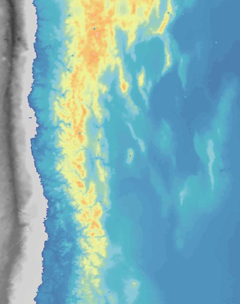
2 Received 2 January 2003; Revised 31 March 2003; Accepted 23 May 2003; Published 8 October Brooks, B. A., M. Bevis, R. Smalley Jr., E. Kendrick, R. Manceda, E. Lauría, R. Maturana, and M. Araujo, Crustal motion in the Southern Andes (26 36 S): Do the Andes behave like a microplate?, Geochem. Geophys. Geosyst., 4(10), 1085, doi:, Introduction [2] Surface velocity fields measured with GPS (Global Positioning System) geodesy promise new insight into the incremental processes that actively deform continents and, over geologic time, construct mountains. For continental regions associated with plate boundaries such as the Andes of South America, an interpretive challenge in relating the GPS-derived velocity field to the long-term deformational pattern is that the current pattern likely represents the superposition of an ephemeral (self-reversing) elastic signal driven by the plate boundary earthquake cycle and steadily accumulating deformation that produces mountain growth. Specifically accounting for these two signals is important if we wish to be able to address first order issues such as the degree of seismic coupling at the main plate boundary [Savage, 1983] and whether specific instances of continental deformation are more aptly described by the relative motions of rigid microplates or as the deformation of a viscous continuum [England and McKenzie, 1982; Thatcher, 1995]. Here, we present a new GPS-derived velocity field from a >1000 km long section of the Andes mountains (26 36 S) (Figure 1, Table 1, Table 2). In our analysis, we test the hypothesis that the orogen itself behaves as a rigid unit with a class of models that combines ephemeral (plate boundary) and permanent (microplate) deformational components. [3] In the Andes, subduction of the oceanic Nazca plate and locking of the subduction interface strains the upper plate until rupture during major earthquakes [Barazangi and Isacks, 1976]. Shortening in backarc contractional orogenic wedges such as the Argentine Precordillera (PC) accommodates underthrusting of the South American craton and makes a significant contribution to permanent orogenic deformation [Allmendinger et al., 1990; Kley and Monaldi, 1998; Ramos et al., 1996]. Norabuena et al. [1998] explained their GPS velocity field for the central Andes (12 22 S) by assuming the Nazca boundary is only 50% locked and that slip of 10 15mm/yr occurs on backarc reverse faults locked to 20km depth. Kendrick et al. [2001] produced an improved velocity field for the region, and Bevis et al. [2001] argued that this favored 100% locking of the Nazca plate boundary and reduced rates of backarc shortening. Similarly, Klotz et al. [2001] concluded that the Nazca plate boundary was fully locked, though their analysis did not explicitly include any velocity component from backarc contraction. [4] Less attention has been focused on interpreting and modeling the velocity field in the backarc region of the Andes, largely because horizontal velocities in these regions tend to be 10 mm/yr or less. In one recent study, however, Lamb [2000] found that velocity gradients (from geologic and Norabuena et al. s [1998] GPS data) do not share the same orientation as calculated buoyancy stress gradients in the central Andean foreland; thus, the thin viscous sheet approximation has not been applied to this portion of the Andes as successfully as it has been Figure 1. (opposite) GPS velocity field superimposed on Andean topography. Inset shows map of South America with the study area highlighted (red box) and stations used to define the reference frame (blue circles). Plates denoted with magenta labels. White contours are of the subducted Nazca plate and red triangles denote schematically the presence of active arc volcanism [Cahill and Isacks, 1992]. Yellow tic mark is the Nazca-South America convergence direction with a magnitude of 63 mm/yr. 2of14
3 3of14
4 Table 1. GPS Site Velocity a Code Lat Long Tspan Vn SigVn Ve SigVe CorNE ACOL AT AT AT AT AT AT AT AT AT AT AT AT AT AT AT AT AT AT AT AT BDSD CALD CBQA CFAG CHAM CHIG CNGT CNST COGO CONA COPO CORR CPDR GNDL GRDA GYCN HUAS INCA JUNT LOBO MALR MGCR MORA MORR MROC NIHL PAGN PALO POBR POTR PSNF PSTO QNTA QPOB RARI RBLS RSTD SANT SIFO SILA of14
5 Table 1. (continued) Code Lat Long Tspan Vn SigVn Ve SigVe CorNE TAFI TENO TINO TOFO TOTO TUCU UPSA a GPS site velocity is expressed relative to the stable South American plate. Code, station code; Lat, latitude; Long, longitude; Tspan, time span of measurements in years; Vn, north component of velocity (mm/yr), SigVn, standard error (mm/yr); Ve, east component of velocity (mm/yr); SigVe, standard error (mm/yr), CorNE, north-east correlation. applied to, for example, the Tibetan plateau [England and Molnar, 1997]. [5] Our study area, between 26 S and 36 S (Figure 1), was chosen so that surface velocity would not be affected by postseismic signals from either the 1995 Antofagasta earthquake to the north [Klotz et al., 1999] or the great 1960 Chile earthquake to the south [Plafker and Savage, 1970]. The region is also of interest because the subducted Nazca slab undergoes a pronounced change in dip with which the basement uplifts of the Sierras Pampeanas range coincide [Jordan et al., 1983] (Figure 1). [6] We installed the network of survey (SGPS) and continuous (CGPS) GPS stations presented here between 1993 and SGPS measurements were carried out from 1993 to 2001 in sessions of at least 40 hours over consecutive days. Our field, processing, and velocity analysis methods have been described elsewhere [Bevis et al., 1997, 2001; Kendrick et al., 2001]. We realize a craton-fixed frame nominally attached to stable South America (Figure 1, inset) with an RMS residual velocity of 1.0 mm/yr. In this reference frame, Andean velocities are directed eastward toward the craton (Figure 1). Velocities are largest (35 mm/yr) closer to the Nazca boundary and decline toward the craton with no obvious evidence of strike-slip deformation [Siame et al., 1997]. Backarc velocity vectors tend to be rotated clockwise with respect to forearc vectors, a pattern similar to that of the south central Andes [Bevis et al., 2001]. Notably, the velocity field shows no obvious or abrupt change in character associated with the changing dip of the subducted Nazca plate (Figure 1). 2. Analysis [7] We analyze the data in a way that simultaneously addresses both the short-term ephemeral deformation related to the earthquake cycle at the Nazca plate boundary and the residual deformation field that leads to backarc contraction and longterm mountain growth. Although we recognize the utility of continuum models based on a thin viscous sheet in examining long-term Andean evolution [Lamb, 2000; Wdowinski et al., 1989], these models do not consider explicitly the short-term elastic deformation related to the plate boundary. Thus we choose to base our analysis on a model that Table 2. Parameter Model Parameters a Value L 1 W AS Lat N W AS Lon W W AS W /Myr w NS Lat N, w NS Lon W w NS w 0.57 /Myr Updip extent 10km Down-dip extent 50km Poisson s ratio.25 a Parameters used in the modeling. Parameters in bold italics are solved for in the 3-plate model inversion, other parameters are held fixed. L, degree of locking on the Nazca boundary; w AS Lat., AS Euler pole latitude; w AS Lon., AS Euler pole longitude; w AS w, AS Euler pole angular velocity; w NS Lat., NS Euler pole latitude; w NS Lon., NS Euler pole longitude; w NS w, NS Euler pole angular velocity; updip extent, updip extent of the locked Nazca boundary; down-dip extent, downdip extent of the locked Nazca boundary; Poisson s ratio, poisson s ratio used in the elastic dislocation modeling. 5of14
6 combines elastic half-space deformation due to slip on embedded discontinuities and the steady motion of rigid plates on a spherical earth [Bevis et al., 2001; McCaffrey, 2002]. [8] To best reproduce the smoothly curving geometry of the subduction zone in this 1000 km long stretch of the Andes we implement our calculations using triangular dislocation elements in an elastic half-space [Bevis et al., 2001]. We find that elastic half-space models driven only by convergence at the Nazca boundary significantly underpredict velocity magnitude at all stations from the trench to the backarc (Figure 2, green vectors). This observation, combined with the evidence that the PC fold and thrust belt has accommodated more than 100 km of shortening during the most recent phase of Andean orogeny [Allmendinger et al., 1990; Jordan et al., 1993; Zapata and Allmendinger, 1996], suggests that a 2-plate model [Williams and McCaffrey, 2001] may be oversimplified, and so we add an independent microplate to the kinematic description of Nazca- South America convergence. [9] Our preferred analysis employs a 3-plate model in which an Andean microplate (A) is located between the Nazca (N) and South America (S) plates (Figure 3). At timescales large compared with that of the earthquake cycle, relative plate motions are steady and can be described using Euler vectors (w) [Cox and Hart, 1986] subject to the constraint that w NS = w NA + w AS. We assume that the A S boundary creeps continuously at a constant rate on what we envision as a sub-horizontal décollement rooted at deeper crustal levels beneath the Andean arc. The only explicit geometrical assumption we make about the A-plate is that the A S surface trace is chosen to correspond with the geologically youngest structures of the thrust front (Figure 2). Where station spacing is sparse, the precise location of the surface trace does not affect the model results. We treat locking of the Nazca boundary as an elastic perturbation superimposed on steady plate convergence [Savage, 1983]. The magnitude of this perturbation, the elastic loading field, is proportional to the degree of locking, L, at the N A boundary. The velocity field in A is then a combination of elastic loading and steady A S plate convergence, whereas in S all motion is due to elastic loading. [10] Previous workers have attempted to model similar data sets by solving for the lower locking depth on the subduction interface [Klotz et al., 2001] as well as solving for the down-dip and along-strike variations in coupling [McCaffrey et al., 2000]. In preliminary analyses we found that inclusion of these added components to the model did not significantly improve model-data misfit while adding as many as 9 parameters to the inverse problem. Thus by assuming uniform along-strike and down-dip coupling and a lower locking depth of 50km we are able to describe our 3 plate model with only 4 parameters (L and the 3 parameters describing the euler vector, w AS ). [11] We find the best-fitting velocity model by repeatedly selecting L and w AS, calculating w NA, and minimizing misfit with an L 1 norm using a Nelder-Mead simplex algorithm. In order to do this we must adopt a value for w NS.We[Kendrick et al., 2003] and others [Angermann et al., 1999; Norabuena et al., 1999] have used GPS velocities to find the modern Euler vector describing N S plate convergence. These studies find convergence velocities significantly slower than the geologically averaged value predicted by the Nuvel 1A plate model [DeMets et al., 1994]; thus, we choose to adopt a modern value as opposed to the other approaches [Ruegg et al., 2002]. We use our estimate for w NS with a pole at 61.1 N, 93.6 W Figure 2. (opposite) GPS velocity field with best 3-plate model (red vectors) and 2-plate model (green vectors) superimposed on Andean topography. Magenta lines denote the western and eastern boundaries of the proposed Andean plate, with the hachures on the overthrusting plate (see Figure 3 for a description of the 3-plate model). White triangles are the dislocation elements used in the elastic portion of the model with the upper ( 10 km) and lower ( 50 km) boundaries constrained by earthquake catalogs [Cahill and Isacks, 1992]. Bold black angle marks contain the yellow stations in the velocity profile which is denoted by the black dashed line (Figure 5).A-A and B-B are the geologic cross-sections in Figure 7. All other annotation as in Figure 1. 6of14
7 7of14
8 Figure 3. Cartoon of the three plate model in a South America fixed reference frame. Magenta lines and symbols as in Figure 2. Dashed magenta line is the locked portion of the subduction zone with degree of locking, L. and a rate of 0.57 /Myr. At a latitude of 31 S, N S plate convergence is 63 mm/yr and is rotated 10 anticlockwise from the normal to the Peru- Chile trench (Figure 2). 3. Results and Discussion [12] The best model, with an RMS velocity misfit of just 1.7 mm/yr (Figure 2), depicts an Andean orogenic system whose boundaries are asymmetrically coupled: the N boundary is 100% locked while the A plate creeps continuously over the S plate with a horizontal velocity of 4.5 mm/yr. To assess the robustness of our findings, for the range of L values, we ran a series of 100 inversions with independent and randomly chosen starting points (Figure 4). The results clearly illustrate that the RMS misfit of the best-fitting models steadily decreases as L is increased toward full locking (Figure 4). [13] The elastic loading component (green vectors, Figure 2; blue line, Figure 5) controls the velocity field s cratonward decay and clockwise rotation [Bevis and Martel, 2001], and it can be recovered by future seismic or aseismic [Dragert et al., 2001; Miller et al., 2002] slip events at the Peru-Chile trench. This component explains 70% or more of the velocity magnitude for stations throughout Figure 4. Plot of RMS velocity misfit versus Nazca boundary locking rate. Fully locked = 1. Each data point represents the minimum value from 100 inversions with independent and randomly chosen starting points. 8of14
9 Figure 5. Velocity profile taken along the dashed line in Figure 2 plots trench-normal distance vs. trench-normal velocity, V?. Yellow circles are stations within the corner marks on Figure 2, white circles are stations outside of the marks. Error bars are 95% confidence. Smooth curves are profiles for the elastic loading component, the best 3-plate model, and the corrected 3-plate model. The green line is the elastic component of the best 3-plate model (red line). The elastic component is equivalent to a 2-plate model. Dashed magenta line is the corrected best model. most of the A plate; far from the trench, it accounts for essentially the entire velocity field in the S plate including the seismically active Sierras Pampeanas region [Costa and Vita-Finzi, 1996] (Figure 5). The w AS (56.5 N, W, /Myr) Euler pole and w NS are only slightly non-coaxial; thus, A S convergence is rotated 10 clockwise from N S plate convergence. The microplate motion contributes a nearly uniform velocity increase for all stations on the A plate and accounts for the steady state portion of the velocity signal. To the extent that we may compare data sets with temporal scales differing by 6 orders of magnitude, the 4.5mm/yr magnitude of the steady signal agrees very well with the post 2.7 Ma shortening rate of 5mm/yr determined for the structures in the eastern PC [Zapata and Allmendinger, 1996]. [14] The excellent agreement between data and model warrants serious consideration of the notion that, at least over the decadal timescale reported here, the Andean region (the A plate) does not accrue significant permanent strains and behaves as a microplate overthrusting the stable South American craton. In support of this, a plot of epicenters of shallow crustal earthquakes (depth < 30 km) from a nearly complete catalog of earthquakes with M w > 5.2 [Engdahl et al., 1998] is consistent with the idea of a stable, largely aseismic, Andean region accruing permanent strains only at its narrow boundary zones (Figure 6). In apparent contrast to the Andes, the region associated with the India-Asia collision and the Himalayan orogen exhibits a diffuse pattern of seismicity distributed throughout the Tibetan plateau (Figure 6) in a manner more consistent with a continental region deforming as a continuum [England and Molnar, 1997]. That the Andean region currently behaves as an independent block whose kinematics can be well-modeled as a microplate, however, does not imply that it has done so consistently during this most recent orogenic phase lasting close to 20 Myrs [Mpodozis and Ramos, 1989]. Proper assessment of the longerterm deformational comportment of the interior Andean region will require significantly more high 9of14
10 Figure 6. Topography and shallow crustal seismicity (<30 km) from A, the Andes and B, the Tibetan plateau taken from the catalog of Engdahl [Engdahl et al., 1998]. resolution studies of quaternary faulting throughout the Andes [Siame et al., 2002, 1997]. [15] In the northern- and southern-most sections of the study area, model vectors nearest the trench tend to be rotated slightly to the north of the data vectors, whereas those closest to the volcanic arc tend to be rotated to the south (Figure 2). These regions of poorer conformance to the 3-plate model are spatially correlated with sections of the mountains where the volcanic arc is currently active and subduction is steep, in contrast to the central portion of the study area where there has been no active arc volcanism for the past 6 Ma and subduction is flat [Isacks, 1988]. We speculate that the active arc may be associated with a thermally weakened zone that leads to this second-order deviation from the 3-plate model. [16] Although the velocity data do not require that intracontinental subduction [Bally and Snelson, 1980] is the active backarc process (similar data from other active orogenic environments such as New Zealand, for example, are explained differently [Beavan et al., 1999]) the kinematics defined by the 3-plate model is consistent with the notion that intracontinental subduction occurs at the A S boundary. In support of this, there is substantial evidence from balanced cross-sections from the study area that continental crust has been underthrust beneath the contractional wedge during the past 20 Ma of Andean orogenesis [Allmendinger et al., 1990; Ramos et al., 1996; Zapata and Allmendinger, 1996]. Additionally, further north, seismological data indicate that the Brazilian craton currently underthrusts the Andean region as far west as the Bolivian Eastern Figure 7. (opposite) Geologic cross-sections and Precordillera velocity field with model and residuals (white vectors) for Figure 7a, the region near San Juan and Figure 7b, the region near Mendoza superimposed on a Land Sat 5 Thematic Mapper mosaic. Symbols as in 1A, error ellipses (95% confidence) referred to residuals. Magenta triangle on cross-sections is location of A-plate boundary. Cross-sections compiled from references in the text and an unpublished section from the Mendoza area. N, Niquivil Anticline; LS, Las Salinas Anticline; B, Bermejo Anticline; LP, La Pilona Anticline; Ba, Barrancas Anticline. In both cross-section and map view the dashed magenta line is the continuously creeping, down-dip extent of the locked zone used as a correction to the preferred model (Figure 5). 10 of 14
11 11 of 14
12 Cordillera [Beck and Zandt, 2002]. We do not, however, intend to suggest that intracontinental subduction has progressed to the point that continental material is being subducted into the mantle beneath the Andean arc - a process that may or may not be physically unlikely [Molnar and Gray, 1979]. [17] Our analysis places strong constraint on the mechanical behavior of the backarc contractional wedge by demonstrating that permanent deformation is currently accommodated at the front of the PC fold and thrust belt and not distributed throughout its width. This is consistent with the narrow band of seismicity described above (Figure 6) and also with post-20 Ma geological reconstructions demonstrating eastward migration of the PC through active deformation near its tip [Jordan et al., 1993; Zapata and Allmendinger, 1996]. In the context of an orogenic wedge whose kinematics are forced by the competition between tectonics and erosion [Dahlen and Suppe, 1988], it is also illustrative to consider mountain belt scale geomorphic indices demonstrating that the eastern margin of the Andes between 17 and 36 S is a regime of relatively low erosional intensity [Montgomery et al., 2001]. The combined geodetic, geologic, and geomorphic analyses suggest that the PC has not attained a steady state balance of erosion and tectonics, but rather, that it continually widens through accretion of new material at its toe. [18] Our modeling is carried out at the plate tectonic scale and is not intended to be precise at the scale of individual structures. For instance, though the model provides an excellent fit to the data as a whole, residual examination demonstrates a small, but systematic velocity overprediction near the A S boundary (Figures 2 and 7). The spatial coherence suggests this signal is significant, albeit second-order, even though individual residual vectors are rarely larger than their associated uncertainty. We can account for this anomaly by modifying our model: we assume that the A S boundary dips westward at 10 and is locked from its tip to a down-dip length of 50km (Figure 7). (Here, we model backarc locking using the backslip formalism in the same way as at the Nazca boundary.) This simple (and probably non-unique) correction is sufficient throughout the PC despite the fact that the structures comprising the locked zone differ in the north and south [Brooks et al., 2000; Jordan et al., 1993; Zapata and Allmendinger, 1996] (Figure 7). In the north, the west-vergent Niquivil, Las Salinas, and Bermejo anticlines comprise the locked zone and the Sierra de Valle Fertil thrust fault, the westernmost expression of the Sierras Pampeanas basement uplifts, abuts the A S boundary (Figure 7a). In the south, the zone is composed of only two, east-vergent structures, the La Pilona and Barrancas anticlines, and the thrust front is separated from the westernmost expression of the Sierras Pampeanas by 200 km of undeformed foreland basin strata (Figure 7d). Discerning the details of deformation in the frontal zone, such as activity, strain accumulation, and seismic hazard of individual structures, will require finer velocity resolution through longer measurement time spans. [19] That we find the décollement below the A-plate to be continuously creeping does not imply that it is freely slipping in the sense that it is shear traction-free. On the contrary, we envision this boundary to be viscously coupled, a configuration that allows both continuous motion and stress transmission across the boundary. Thus we speculate that transmission of stresses across the fully locked oceanic subduction boundary drives microplate motion and deformation at the intracontinental boundary. If the stress drop associated with major subduction earthquakes is small compared to the failure stress, then creep at the A S boundary should vary only slightly during the earthquake deformation cycle at the Nazca boundary. Acknowledgments [20] Funding provided by NSF grants EAR and EAR We thank R. Allmendinger and C. Wolfe for previous reviews of this paper. We especially acknowledge Fernando Galban of IGM Argentina for his continuing support and collaboration. We gratefully acknowledge the many peo- 12 of 14
13 ple whose collaboration in the field made this project possible. These include but are not limited to: A. A. Garcia, B. Knight, R. Barriga, H. Parra, W. Rubio, P. Gallardo, J. Baron, M. Blanco, P. Euillades, L. Euillades, V. Bonfils, G. Cabrera, C. Gardini, J. Argento, S. Bea, J. Yu, M. Burns, M. Patrick, and F. Forconesi. This is SOEST contribution 6174 and CERI contribution 473. References Allmendinger, R., D. Figueroa, D. Snyder, J. Beer, C. Mpodozis, and B. L. Isacks, Foreland shortening and crustal balancing in the Andes at 30 S latitude, Tectonics, 9, , Angermann, D., J. Klotz, and C. Reigber, Space-geodetic estimation of the Nazca-South America Euler vector, Earth Planet. Sci. Lett., 171, , Bally, A. W., and S. Snelson, Realms of subsidence, in Facts and Principles of World Oil Occurrence, vol. 6, edited by A. D. Miall, pp. 9 75, Can. Soc. of Petrol. Geol., Calgory, Barazangi, M., and B. Isacks, Spatial distribution of earthquakes and subduction of the Nazca plate beneath South America, Geology, 4, , Beavan, J., et al., Crustal deformation during due to oblique continental collision in the central Southern Alps, New Zealand, and implications for seismic potential of the Alpine Fault, J. Geophys. Res., 104, 25,233 25,255, Beck, S. L., and G. Zandt, The nature of orogenic crust in the central Andes, J. Geophys. Res., 107(B10), 2230, doi: /2000jb000124, Bevis, M., and S. Martel, Oblique plate convergence and interseismic strain accumulation, Geochem. Geophys. Geosyst., 2, Paper number 2000GC000125, Bevis, M., Y. Bock, P. Fang, R. Reilinger, T. Herring, J. Stowell, and R. SmalleyJr., Blending oldand newapproaches to regional geodesy, Eos Trans. AGU, 78, 61, 64 66, Bevis, M., E. Kendrick, R. Smalley Jr., B. A. Brooks, R. W. Allmendinger, and B. L. Isacks, On the strength of interplate coupling and the rate of back arc convergence in the central Andes: An analysis of the interseismic velocity field, Geochem. Geophys. Geosyst., 2, /2001GC000198, Brooks, B. A., E. Sandvol, and A. Ross, Fold style inversion: Placing probabilistic constraints on the predicted shape of blind thrust faults, J. Geophys. Res., 105, 13,281 13,302, Cahill, T., and B. L. Isacks, Seismicity and shape of the subducted Nazca plate, J. Geophys. Res., 97, 17,503 17,529, Costa, C. H., and C. Vita-Finzi, Late Holocene faulting in the southeast Sierras Pampeanas of Argentina, Geology, 24, , Cox, A., and R. B. Hart, Plate Tectonics How it Works, 392 pp., Blackwell Sci., Cambridge, Mass., Dahlen, F. A., and J. Suppe, Mechanics, growth, and erosion of mountain belts, Spec. Pap. Geol. Soc. Am., 218, , DeMets, C., R. G. Gordon, D. F. Argus, and S. Stein, Effect of recent revisions to the geomagnetic reversal time scale on estimates of current plate motions, Geophys. Res. Lett., 21, , Dragert, H., K. Wang, and T. S. James, A silent slip event on the deeper Cascadia subduction interface, Science, 292, , Engdahl, E. R., R. D. van der Hilst, and R. P. Buland, Global teleseismic earthquake relocation with improved travel times and procedures for depth determination, Bull. Seismol. Soc. Am., 88, , England, P., and D. McKenzie, A thin viscous sheet model for continental deformation, Geophys. J. R. Astron. Soc., 70, , England, P., and P. Molnar, Active deformation of Asia; from kinematics to dynamics, Science, 278, , Isacks, B. L., Uplift of the Central Andean Plateau and Bending of the Bolivian Orocline, J. Geophys. Res., 93, , Jordan, T. E., B. L. Isacks, R. W. Allmendinger, J. A. Brewer, V. Ramos, and C. J. Ando, Andean tectonics related to geometry of subducted Nazca plate, Geol. Soc. Am. Bull., 94, , Jordan, T. E., R. W. Allmendinger, J. F. Damanti, and R. E. Drake, Chronology of motion in a complete thrust belt: The Precordillera, S, Andes Mountains, J. Geol., 101, , Kendrick, E., M. G. Bevis, R. Smalley Jr., and B. A. Brooks, An integrated crustal velocity field for the central Andes, Geochem. Geophys. Geosyst., 2, /2001GC000191, Kendrick, E., M. Bevis, R. Smalley Jr., B. Brooks, R. B. Vargas,E.Lauría, and L. P. S. Fortes, The Nazca-South America Euler Vector and its Rate of Change, J. South Am. Earth Sci., in press, Kley, J., and C. R. Monaldi, Tectonic shortening and crustal thickness in the Central Andes: How good is the correlation, Geology, 26, , Klotz, J., et al., GPS-derived Deformation of the Central Andes Including the 1995 Antofagasta Mw = 8.0 Earthquake, Pure Appl. Geophys., 154, , Klotz, J., G. Khazaradze, D. Angermann, C. Reigber, R. Perdomo, and O. Cifuentes, Earthquake cycle dominates contemporary crustal deformation in Central and Southern Andes, Earth Planet. Sci. Lett., 193, , Lamb, S., Active deformation in the Bolivian Andes, South America, J. Geophys. Res., 105, 25,627 25,653, McCaffrey, R., Crustal block rotations and plate coupling, in Plate Boundary Zones, Geodyn. Ser., vol. 30, edited by S. Stein and J. T. Freymueller, pp , AGU, Washington, D.C., McCaffrey, R., M. D. Long, C. Goldfinger, P. C. Zwick, J. L. Nabelek, C. K. Johnson, and C. Smith, Rotation and plate locking at the southern Cascadia subduction zone, Geophys. Res. Lett., 27, , Miller, M. M., T. Melbourne, D. J. Johnson, and W. Q. Sumner, Periodic slow earthquakes from the Cascadia Subduction Zone, Science, 295, 2423, of 14
14 Molnar, P., and D. Gray, Subduction of continental lithosphere: Some constraints and uncertainties, Geology, 7, 58 62, Montgomery, D. R., G. Balco, and S. D. Willett, Climate, tectonics, and the morphology of the Andes, Geology, 29, , Mpodozis, C., and V. Ramos, The Andes of Chile and Argentina, in Geology of the Andes and its Relation to Hydrocarbon and Mineral Resources, Earth Sci. Ser., edited by G. E. Ericksen et al., pp , Circum-Pacific Council for Energy and Mineral Resources, Menlo Park, Calif., Norabuena, E. O., T. H. Dixon, S. Stein, and C. G. A. Harrison, Decelerating Nazca-South America and Nazca- Pacific plate motions, Geophys. Res. Lett., 26, , Plafker, G., and J. C. Savage, Mechanism of the Chilean earthquake of May 21 and 22, 1960, Geol. Soc. Am. Bull., 81, , Ramos, V. A., M. Cegarra, and E. Cristallini, Cenozoic tectonics of the High Andes of west-central Argentina (30 36 latitude), Tectonophysics, 259, , Ruegg,J.C.,J.Campos,R.Madariaga,E.Kausel,J.B. de Chabalier, R. Armijo, D. Dimitriv, I. Georgiev, and S. Barrientos, Interseismic strain accumulation in south central Chile from GPS measurements, , Geophys. Res. Lett., 29, 1517, Savage, J. C., A dislocation model of strain accumulation and release at a subduction zone, J. Geophys. Res., 88, , Siame, L. L., D. L. Bourles, M. Sebrier, O. Bellier, J. C. Castano, M. Araujo, M. Perez, G. M. Raisbeck, and F. Yiou, Cosmogenic dating ranging from 20 to 700 ka of a series of alluvial fan surfaces affected by the El Tigre fault, Argentina, Geology, 25, , Siame, L. L., O. Bellier, M. Sebrier, D. L. Bourles, P. Leturmy, and M. Perez, Seismic hazard reappraisal from combined structural geology, geomorphology and cosmic ray exposure dating analyses: The Eastern Precordillera thrust system (NW Argentina), Geophys. J. Int., 150, , Thatcher, W. R., Microplate versus continuum descriptions of active tectonic deformation: J. Geophys. Res., 100, , Wdowinski, S., R. J. O Connell, and P. England, A continuum model of continental deformation above subduction zones; application to the Andes and the Aegean, J. Geophys. Res., 94, 10,331 10,346, Williams, C., and R. McCaffrey, Stress rates in the central Cascadia subduction zone inferred from an elastic plate model, Geophys. Res. Lett., 28, , Zapata, T. R., and R. W. Allmendinger, Growth stratal records of instantaneous and progressive limb rotation in the Precordillera thrust belt and Bermejo basin, Argentina, Tectonics, 15, , of 14
Supplementary Material
 1 Supplementary Material 2 3 4 Interseismic, megathrust earthquakes and seismic swarms along the Chilean subduction zone (38-18 S) 5 6 7 8 9 11 12 13 14 1 GPS data set We combined in a single data set
Why short-term crustal shortening leads to mountain building in the Andes, but not in Cascadia?
 Click Here for Full Article GEOPHYSICAL RESEARCH LETTERS, VOL. 36, L08301, doi:10.1029/2009gl037347, 2009 Why short-term crustal shortening leads to mountain building in the Andes, but not in Cascadia?
The Nazca South America Euler vector and its rate of change
 Journal of South American Earth Sciences 16 (2003) 125 131 www.elsevier.com/locate/jsames The Nazca South America Euler vector and its rate of change Eric Kendrick a, Michael Bevis a, *, Robert Smalley
Global Tectonics. Kearey, Philip. Table of Contents ISBN-13: Historical perspective. 2. The interior of the Earth.
 Global Tectonics Kearey, Philip ISBN-13: 9781405107778 Table of Contents Preface. Acknowledgments. 1. Historical perspective. 1.1 Continental drift. 1.2 Sea floor spreading and the birth of plate tectonics.
CONTINENTAL PLATE BOUNDARY ZONES
 CONTINENTAL PLATE BOUNDARY ZONES Plate boundaries initially viewed as narrow Now recognize that many plate boundaries - especially continental - are deformation zones up to 1000 km wide, with motion spread
Three-dimensional viscoelastic finite element model for postseismic deformation of the great 1960 Chile earthquake
 JOURNAL OF GEOPHYSICAL RESEARCH, VOL. 109,, doi:10.1029/2004jb003163, 2004 Three-dimensional viscoelastic finite element model for postseismic deformation of the great 1960 Chile earthquake Y. Hu, 1 K.
 Sedimentary Basin Analysis http://eqsun.geo.arizona.edu/geo5xx/geos517/ Sedimentary basins can be classified based on the type of plate motions (divergent, convergent), type of the lithosphere, distance
Activity Pacific Northwest Tectonic Block Model
 Activity Pacific Northwest Tectonic Block Model The Cascadia tectonic margin is caught between several tectonic forces, during the relentless motions of the giant Pacific Plate, the smaller subducting
GPS Strain & Earthquakes Unit 5: 2014 South Napa earthquake GPS strain analysis student exercise
 GPS Strain & Earthquakes Unit 5: 2014 South Napa earthquake GPS strain analysis student exercise Strain Analysis Introduction Name: The earthquake cycle can be viewed as a process of slow strain accumulation
Comment on A new estimate for present-day Cocos-Caribbean plate motion: Implications
 Comment on A new estimate for present-day Cocos-Caribbean plate motion: Implications for slip along the Central American volcanic arc by Charles DeMets Marco Guzmán-Speziale Juan Martín Gómez Unidad de
Study megathrust creep to understand megathrust earthquakes
 1 Study megathrust creep to understand megathrust earthquakes Kelin Wang Pacific Geoscience Centre, Geological Survey of Canada, kelin.wang@canada.ca Introduction Once upon a time, there was a belief that
Mountain Building. Mountain Building
 Mountain Building Mountain building has occurred during the recent geologic past American Cordillera the western margin of the Americas from Cape Horn to Alaska Includes the Andes and Rocky Mountains Alpine
Kinematics of the Southern California Fault System Constrained by GPS Measurements
 Title Page Kinematics of the Southern California Fault System Constrained by GPS Measurements Brendan Meade and Bradford Hager Three basic questions Large historical earthquakes One basic question How
Deformation of Rocks. Orientation of Deformed Rocks
 Deformation of Rocks Folds and faults are geologic structures caused by deformation. Structural geology is the study of the deformation of rocks and its effects. Fig. 7.1 Orientation of Deformed Rocks
DEFORMATION KINEMATICS OF TIBETAN PLATEAU DETERMINED FROM GPS OBSERVATIONS
 DEFORMATION KINEMATICS OF TIBETAN PLATEAU DETERMINED FROM GPS OBSERVATIONS Jinwei Ren Institute of Geology, China Seismological Bureau, Beijing 100029 China Tel: (10)62009095; Fax: (10)62009003; email:
Power-law distribution of fault slip-rates in southern California
 Click Here for Full Article GEOPHYSICAL RESEARCH LETTERS, VOL. 34, L23307, doi:10.1029/2007gl031454, 2007 Power-law distribution of fault slip-rates in southern California Brendan J. Meade 1 Received 31
Evolution of Continents Chapter 20
 Evolution of Continents Chapter 20 Does not contain complete lecture notes. Mountain belts Orogenesis the processes that collectively produce a mountain belt Includes folding, thrust faulting, metamorphism,
The Tectonic Setting of New Zealand
 The Tectonic Setting of New Zealand we are here Subduction-driven tectonics The New Zealand continent Papua New Guinea Australia 3,000,000 sq km micro-continent back-arc basin trench volcanism faults accretionary
Lecture Outlines PowerPoint. Chapter 10 Earth Science, 12e Tarbuck/Lutgens
 Lecture Outlines PowerPoint Chapter 10 Earth Science, 12e Tarbuck/Lutgens 2009 Pearson Prentice Hall This work is protected by United States copyright laws and is provided solely for the use of instructors
Copyright McGraw-Hill Education. All rights reserved. No reproduction or distribution without the prior written consent of McGraw-Hill Education
 Copyright McGraw-Hill Education. All rights reserved. No reproduction or distribution without the prior written consent of McGraw-Hill Education Tibetan Plateau and Himalaya -southern Asia 11.00.a VE 10X
USU 1360 TECTONICS / PROCESSES
 USU 1360 TECTONICS / PROCESSES Observe the world map and each enlargement Pacific Northwest Tibet South America Japan 03.00.a1 South Atlantic Arabian Peninsula Observe features near the Pacific Northwest
Earth Science, (Tarbuck/Lutgens) Chapter 10: Mountain Building
 Chapter 10: Mountain Building") Earth Science, (Tarbuck/Lutgens) Chapter 10: Mountain Building 1) A(n) fault has little or no vertical movements of the two blocks. A) stick slip B) oblique slip C) strike slip D) dip slip 2) In a(n) fault,
Earth Science, (Tarbuck/Lutgens) Chapter 10: Mountain Building 1) A(n) fault has little or no vertical movements of the two blocks. A) stick slip B) oblique slip C) strike slip D) dip slip 2) In a(n) fault,
Long-term Crustal Deformation in and around Japan, Simulated by a 3-D Plate Subduction Model
 Long-term Crustal Deformation in and around Japan, Simulated by a 3-D Plate Subduction Model Chihiro Hashimoto (1) and Mitsuhiro Matsu ura (2) (1) Institute of Frontier Research for Earth Evolution, Japan
Measurements in the Creeping Section of the Central San Andreas Fault
 Measurements in the Creeping Section of the Central San Andreas Fault Introduction Duncan Agnew, Andy Michael We propose the PBO instrument, with GPS and borehole strainmeters, the creeping section of
Regional deformation and kinematics from GPS data
 Regional deformation and kinematics from GPS data Jessica Murray, Jerry Svarc, Elizabeth Hearn, and Wayne Thatcher U. S. Geological Survey Acknowledgements: Rob McCaffrey, Portland State University UCERF3
09/06/2017. The orogenic cycle in the Andes: Arc magmatism and delamination as control of the fold and thrust belts
 The orogenic cycle in the Andes: Arc magmatism and delamination as control of the fold and thrust belts Victor A. Ramos Laboratorio de Tectónica Andina Instituto de Estudios Andinos Don Pablo Groeber Universidad
Surface changes caused by erosion and sedimentation were treated by solving: (2)
") GSA DATA REPOSITORY 214279 GUY SIMPSON Model with dynamic faulting and surface processes The model used for the simulations reported in Figures 1-3 of the main text is based on two dimensional (plane strain)
GSA DATA REPOSITORY 214279 GUY SIMPSON Model with dynamic faulting and surface processes The model used for the simulations reported in Figures 1-3 of the main text is based on two dimensional (plane strain)
Regional Geodesy. Shimon Wdowinski. MARGINS-RCL Workshop Lithospheric Rupture in the Gulf of California Salton Trough Region. University of Miami
 MARGINS-RCL Workshop Lithospheric Rupture in the Gulf of California Salton Trough Region Regional Geodesy Shimon Wdowinski University of Miami Rowena Lohman, Kim Outerbridge, Tom Rockwell, and Gina Schmalze
G 3. AN ELECTRONIC JOURNAL OF THE EARTH SCIENCES Published by AGU and the Geochemical Society
 Geosystems G 3 AN ELECTRONIC JOURNAL OF THE EARTH SCIENCES Published by AGU and the Geochemical Society Article Volume 2 November 1, 2001 Paper number 2001GC000198 ISSN: 1525-2027 On the strength of interplate
Lateral extrusion and tectonic escape in Ilan Plain of northeastern Taiwan
 Lateral extrusion and tectonic escape in Ilan Plain of northeastern Taiwan Angelier, J., Chang, T.Y., Hu, J.C., Chang, C.P., Siame, L., Lee, J.C., Deffontaines, B., Chu, H.T, Lu, C.Y., Does extrusion occur
Contractional Tectonics: Convergence and Collision
 Contractional Tectonics: Convergence and Collision Processes in Structural Geology & Tectonics Ben van der Pluijm WW Norton+Authors, unless noted otherwise 4/12/2017 5:21 PM We Discuss Contractional Tectonics
ACTIVE OROGENY OF THE SOUTH-CENTRAL ANDES STUDIED WITH GPS GEODESY
 Revista de la Asociación Geológica Argentina 61 (4): 555-566 (2006) 555 ACTIVE OROGENY OF THE SOUTH-CENTRAL ANDES STUDIED WITH GPS GEODESY Eric KENDRICK 1, Benjamin A. BROOKS 2*, Michael BEVIS 1, Robert
Plate Tectonics. entirely rock both and rock
 Plate Tectonics I. Tectonics A. Tectonic Forces are forces generated from within Earth causing rock to become. B. 1. The study of the origin and arrangement of Earth surface including mountain belts, continents,
ANOTHER MEXICAN EARTHQUAKE! Magnitude 7.1, Tuesday Sept. 19, 2017
 ANOTHER MEXICAN EARTHQUAKE! Magnitude 7.1, Tuesday Sept. 19, 2017 Why is there no oceanic crust older than 200 million years? SUBDUCTION If new oceanic crust is being continuously created along the earth
Deformation cycles of great subduction earthquakes in a viscoelastic Earth
 Deformation cycles of great subduction earthquakes in a viscoelastic Earth Kelin Wang Pacific Geoscience Centre, Geological Survey of Canada School of Earth and Ocean Science, University of Victoria????
Three-dimensional viscoelastic interseismic deformation model for the Cascadia subduction zone
 Earth Planets Space, 53, 295 306, 2001 Three-dimensional viscoelastic interseismic deformation model for the Cascadia subduction zone Kelin Wang, Jiangheng He, Herb Dragert, and Thomas S. James Pacific
SUPPLEMENTARY INFORMATION
 SUPPLEMENTARY INFORMATION doi: 10.1038/ngeo739 Supplementary Information to variability and distributed deformation in the Marmara Sea fault system Tobias Hergert 1 and Oliver Heidbach 1,* 1 Geophysical
Essentials of Geology, 11e
 Essentials of Geology, 11e Crustal Deformation and Mountain Building Chapter 17 Instructor Jennifer Barson Spokane Falls Community College Geology 101 Stanley Hatfield Southwestern Illinois College Jennifer
Seismological laboratory in Agua Negra tunnel
 Instituto Geofísico Sismológico Volponi Universidad Nacional de San Juan Seismological laboratory in Agua Negra tunnel Buenos Aires, Abril 2011 Why a Seismological laboratory in Agua Negra tunnel? Earthquake
Subduction zones are complex plate boundaries in which variable geometry and structure can be
 1 Chapter 1 Introduction Subduction zones are complex plate boundaries in which variable geometry and structure can be seismically observed. The along-strike transition from flat to normal subduction is
A) B) C) D) 4. Which diagram below best represents the pattern of magnetic orientation in the seafloor on the west (left) side of the ocean ridge?
 B) C) D) 4. Which diagram below best represents the pattern of magnetic orientation in the seafloor on the west (left) side of the ocean ridge?") 1. Crustal formation, which may cause the widening of an ocean, is most likely occurring at the boundary between the A) African Plate and the Eurasian Plate B) Pacific Plate and the Philippine Plate C)
1. Crustal formation, which may cause the widening of an ocean, is most likely occurring at the boundary between the A) African Plate and the Eurasian Plate B) Pacific Plate and the Philippine Plate C)
GRAVIMETRIC MAP OF CHILE. Services Mining and Engineering Geophysics Instituto Geográfico Militar
 GRAVIMETRIC MAP OF CHILE Araneda M., Rivas L., Avendaño M, Sottolichio G., Rubio W. Services Mining and Engineering Geophysics segmi@netexpress.cl) Instituto Geográfico Militar (lrivas@igm.cl) Abstract
NAME HOMEWORK ASSIGNMENT #4 MATERIAL COVERS CHAPTERS 19, 20, 21, & 2
 NAME HOMEWORK ASSIGNMENT #4 MATERIAL COVERS CHAPTERS 19, 20, 21, & 2 Assignment is due the beginning of the class period on December 14, 2004. Mark answers on a scantron sheet, which will be provided.
Overview of the Seismic Source Characterization for the Palo Verde Nuclear Generating Station
 Overview of the Seismic Source Characterization for the Palo Verde Nuclear Generating Station Scott Lindvall SSC TI Team Lead Palo Verde SSC SSHAC Level 3 Project Tuesday, March 19, 2013 1 Questions from
North America subducted under Rubia. Are there modern analogs for Hildebrand s model of North America subducting under Rubia?
 North America subducted under Rubia Are there modern analogs for Hildebrand s model of North America subducting under Rubia? In the Geological Society of America Special Papers Did Westward Subduction
Seismic Activity near the Sunda and Andaman Trenches in the Sumatra Subduction Zone
 IJMS 2017 vol. 4 (2): 49-54 International Journal of Multidisciplinary Studies (IJMS) Volume 4, Issue 2, 2017 DOI: http://doi.org/10.4038/ijms.v4i2.22 Seismic Activity near the Sunda and Andaman Trenches
The ~ Ma magmatism along the Mesozoic arc is far more voluminous than would be expected for a typical arc.
 The ~120-80 Ma magmatism along the Mesozoic arc is far more voluminous than would be expected for a typical arc. Is Hildebrand s model substantially different from the under-thrusting of continental sediments
Topography growth drives stress rotations in the central Andes: Observations and models
 Click Here for Full Article GEOPHYSICAL RESEARCH LETTERS, VOL. 35, L08301, doi:10.1029/2007gl032782, 2008 Topography growth drives stress rotations in the central Andes: Observations and models Oliver
Dynamic Subsidence and Uplift of the Colorado Plateau. Supplementary Material
 GSA DATA REPOSITORY 2010177 Liu and Gurnis Dynamic Subsidence and Uplift of the Colorado Plateau Supplementary Material Lijun Liu and Michael Gurnis Seismological Laboratory California Institute of Technology
SUPPLEMENTARY INFORMATION
 doi: 1.138/nature962 Data processing A network of 5 continuously recording GPS stations (LAGU, CHIN, ENAP, GUAD and JUAN) was installed after the earthquake (Figure 1, main text). The data considered in
3. PLATE TECTONICS LAST NAME (ALL IN CAPS): FIRST NAME: PLATES
: FIRST NAME: PLATES") LAST NAME (ALL IN CAPS): FIRST NAME: PLATES 3. PLATE TECTONICS The outer layers of the Earth are divided into the lithosphere and asthenosphere. The division is based on differences in mechanical properties
LAST NAME (ALL IN CAPS): FIRST NAME: PLATES 3. PLATE TECTONICS The outer layers of the Earth are divided into the lithosphere and asthenosphere. The division is based on differences in mechanical properties
The problem (1/2) GPS velocity fields in plate boundary zones are very smooth. What does this smoothness hide?
 GPS velocity fields in plate boundary zones are very smooth. What does this smoothness hide?") Block models The problem (1/2) GPS velocity fields in plate boundary zones are very smooth Figure from Tom Herring, MIT What does this smoothness hide? Continuous deformation? Rigid block motions, with
Block models The problem (1/2) GPS velocity fields in plate boundary zones are very smooth Figure from Tom Herring, MIT What does this smoothness hide? Continuous deformation? Rigid block motions, with
overlie the seismogenic zone offshore Costa Rica, making the margin particularly well suited for combined land and ocean geophysical studies (Figure
 Chapter 1 Introduction Historically, highly destructive large magnitude (M w >7.0) underthrusting earthquakes nucleate along the shallow segment of subduction zone megathrust fault, and this region of
Ground displacement in a fault zone in the presence of asperities
 BOLLETTINO DI GEOFISICA TEORICA ED APPLICATA VOL. 40, N. 2, pp. 95-110; JUNE 2000 Ground displacement in a fault zone in the presence of asperities S. SANTINI (1),A.PIOMBO (2) and M. DRAGONI (2) (1) Istituto
Splay fault and megathrust earthquake slip in the Nankai Trough
 Earth Planets Space, 53, 243 248, 2001 Splay fault and megathrust earthquake slip in the Nankai Trough Phil R. Cummins, Takane Hori, and Yoshiyuki Kaneda Frontier Research Program for Subduction Dynamics,
GPS strain analysis examples Instructor notes
 GPS strain analysis examples Instructor notes Compiled by Phil Resor (Wesleyan University) This document presents several examples of GPS station triplets for different tectonic environments. These examples
Originally published as:
 Originally published as: Lorenzo Martín, F., Wang, R., Roth, F. (2002): The effect of input parameters on visco-elastic models of crustal deformation. - Física de la Tierra, 14, 33-54 The effect of input
The Earthquake of Padang, Sumatra of 30 September 2009 scientific information and update
 The Earthquake of Padang, Sumatra of 30 September 2009 scientific information and update 01-October-2009 Christophe Vigny Directeur de recherches at CNRS Laboratoire de Géologie Geoscience Dept. Of ENS,
Development of a Predictive Simulation System for Crustal Activities in and around Japan - II
 Development of a Predictive Simulation System for Crustal Activities in and around Japan - II Project Representative Mitsuhiro Matsu'ura Graduate School of Science, The University of Tokyo Authors Mitsuhiro
PLATE MOTIONS: BASIC CONCEPTS
 PLATE MOTIONS: BASIC CONCEPTS North American plate 20 mm/yr Eurasian plate Pacific plate 35 mm/yr North American plate Iceland Spreading Center, Thingvellir San Andreas Transform Fault Carrizo Plain BASIC
Using deformation rates in Northern Cascadia to constrain time-dependent stress- and slip-rate on the megathrust
 Using deformation rates in Northern Cascadia to constrain time-dependent stress- and slip-rate on the megathrust Lucile Bruhat Paul Segall Stanford University 1 50 Interseismic period for the Cascadia
Sendai Earthquake NE Japan March 11, Some explanatory slides Bob Stern, Dave Scholl, others updated March
 Sendai Earthquake NE Japan March 11, 2011 Some explanatory slides Bob Stern, Dave Scholl, others updated March 14 2011 Earth has 11 large plates and many more smaller ones. Plates are 100-200 km thick
GPS Strain & Earthquakes Unit 4: GPS strain analysis examples Student exercise
 GPS Strain & Earthquakes Unit 4: GPS strain analysis examples Student exercise Example 1: Olympic Peninsula Name: Please complete the following worksheet to estimate, calculate, and interpret the strain
The influence of short wavelength variations in viscosity on subduction dynamics
 1 Introduction Deformation within the earth, driven by mantle convection due primarily to cooling and subduction of oceanic lithosphere, is expressed at every length scale in various geophysical observations.
Answers: Internal Processes and Structures (Isostasy)
") Answers: Internal Processes and Structures (Isostasy) 1. Analyse the adjustment of the crust to changes in loads associated with volcanism, mountain building, erosion, and glaciation by using the concept
Answers: Internal Processes and Structures (Isostasy) 1. Analyse the adjustment of the crust to changes in loads associated with volcanism, mountain building, erosion, and glaciation by using the concept
Azimuth with RH rule. Quadrant. S 180 Quadrant Azimuth. Azimuth with RH rule N 45 W. Quadrant Azimuth
 30 45 30 45 Strike and dip notation (a) N30 E, 45 SE ("Quadrant"): the bearing of the strike direction is 30 degrees east of north and the dip is 45 degrees in a southeast (SE) direction. For a given strike,
Oblique convergence between India and Eurasia
 JOURNAL OF GEOPHYSICAL RESEARCH, VOL. 107, NO. B5, 10.1029/2001JB000636, 2002 Oblique convergence between India and Eurasia Muhammad A. Soofi and Scott D. King Department of Earth and Atmospheric Sciences,
Segmentation in episodic tremor and slip all along Cascadia
 Segmentation in episodic tremor and slip all along Cascadia Michael R. Brudzinski and Richard M. Allen Geology 35 (10) 907-910, 2007, doi: 10.1130/G23740A.1 Data Repository: Methods for Automated Data
Crustal deformation and fault slip during the seismic cycle in the North Chile subduction zone, from GPS and InSAR observations
 Geophys J Int (24) 158, 695 711 doi: 11111/j1365-246X242326x Crustal deformation and fault slip during the seismic cycle in the North Chile subduction zone, from GPS and InSAR observations M Chlieh, 1,
12. The diagram below shows the collision of an oceanic plate and a continental plate.
 Review 1. Base your answer to the following question on the cross section below, which shows the boundary between two lithospheric plates. Point X is a location in the continental lithosphere. The depth
Plate Tectonics. Structure of the Earth
 Plate Tectonics Structure of the Earth The Earth can be considered as being made up of a series of concentric spheres, each made up of materials that differ in terms of composition and mechanical properties.
The Size and Duration of the Sumatra-Andaman Earthquake from Far-Field Static Offsets
 The Size and Duration of the Sumatra-Andaman Earthquake from Far-Field Static Offsets P. Banerjee, 1 F. F. Pollitz, 2 R. Bürgmann 3 * 1 Wadia Institute of Himalayan Geology, Dehra Dun, 248001, India. 2
GEOPHYSICAL RESEARCH LETTERS, VOL. 37, L02304, doi: /2009gl041835, 2010
 Click Here for Full Article GEOPHYSICAL RESEARCH LETTERS, VOL. 37,, doi:10.1029/2009gl041835, 2010 Seismic structure of the Longmen Shan region from S wave tomography and its relationship with the Wenchuan
Chapter 15 Structures
 Chapter 15 Structures Plummer/McGeary/Carlson (c) The McGraw-Hill Companies, Inc. TECTONIC FORCES AT WORK Stress & Strain Stress Strain Compressive stress Shortening strain Tensional stress stretching
2008 Monitoring Research Review: Ground-Based Nuclear Explosion Monitoring Technologies
 STRUCTURE OF THE KOREAN PENINSULA FROM WAVEFORM TRAVEL-TIME ANALYSIS Roland Gritto 1, Jacob E. Siegel 1, and Winston W. Chan 2 Array Information Technology 1 and Harris Corporation 2 Sponsored by Air Force
GENERAL GEOLOGY Fall Chapter 18: The Sea Floor. Partial Examination IV Study Guide Dr. Glen S. Mattioli
 GENERAL GEOLOGY 1113-005 Fall 2008 Partial Examination IV Study Guide Dr. Glen S. Mattioli Note that these are NOT questions, but rather are a list of topics that we have covered either in class or are
DOWNLOAD OR READ : SHALLOW SUBDUCTION ZONES SEISMICITY MECHANICS AND SEISMIC POTENTIAL PDF EBOOK EPUB MOBI
 DOWNLOAD OR READ : SHALLOW SUBDUCTION ZONES SEISMICITY MECHANICS AND SEISMIC POTENTIAL PDF EBOOK EPUB MOBI Page 1 Page 2 shallow subduction zones seismicity mechanics and seismic potential shallow subduction
A viscoelastic model of interseismic strain concentration in Niigata-Kobe Tectonic Zone of central Japan
 Earth Planets Space, 55, 667 675, 2003 A viscoelastic model of interseismic strain concentration in Niigata-Kobe Tectonic Zone of central Japan Mamoru Hyodo 1 and Kazuro Hirahara 2 1 Graduate School of
Estimating fault slip rates, locking distribution, elastic/viscous properites of lithosphere/asthenosphere. Kaj M. Johnson Indiana University
 3D Viscoelastic Earthquake Cycle Models Estimating fault slip rates, locking distribution, elastic/viscous properites of lithosphere/asthenosphere Kaj M. Johnson Indiana University In collaboration with:
Mountain Belts and Earthquakes
 Mountain Belts and Earthquakes Lessons from the Andes From Elger (2005) Venzone, Italy, October 2011 Two lessons from the Andes for Friuli Present-day geology controls aspects of seismogenesis as well
Earthquakes in Barcelonnette!
 Barcelonnette in the Ubaye valley : the landscape results of large deformations during the alpine orogene (40 5 Myr in this area) and the succession of Quaternary glaciations. The sedimentary rocks are
Dynamic Crust Practice
 1. Base your answer to the following question on the cross section below and on your knowledge of Earth science. The cross section represents the distance and age of ocean-floor bedrock found on both sides
Do NOT open the test until instructed to do so.
 Raw Score: Rank: School: Team Number: Names: Boyceville Invitational, December 2, 2017 Dynamic Planet Plate Tectonics and Geographical Impacts Do NOT open the test until instructed to do so. 2011 Tohoku
Synthetic Seismicity Models of Multiple Interacting Faults
 Synthetic Seismicity Models of Multiple Interacting Faults Russell Robinson and Rafael Benites Institute of Geological & Nuclear Sciences, Box 30368, Lower Hutt, New Zealand (email: r.robinson@gns.cri.nz).
SCIENCE CHINA Earth Sciences
 SCIENCE CHINA Earth Sciences RESEARCH PAPER September 2011 Vol.54 No.9: 1386 1393 doi: 10.1007/s11430-011-4177-2 Crustal P-wave velocity structure of the Longmenshan region and its tectonic implications
Mountains are then built by deforming crust: Deformation & Mountain Building. Mountains form where stresses are high!
 Deformation & Mountain Building Where are mountains located? Deformation and Folding Mountain building Mountains form where stresses are high! Mountains form at all three types of plate boundaries where
Ongoing Oroclinal bending in the Cascadia forearc and its relation to concave-outboard plate margin geometry
 GSA DATA REPOSITORY 2019058 Ongoing Oroclinal bending in the Cascadia forearc and its relation to concave-outboard plate margin geometry Theron Finley 1,2, Kristin Morell 1,3, Lucinda Leonard 1, Christine
Earthquake Mechanisms and Plate Tectonics
 7 Earthquake Mechanisms and Plate Tectonics Seth Stein and Eryn Klosko Northwestern University, Evanston, Illinois, USA 1 Introduction Earthquake seismology has played a major role in the development of
Earthquake distribution is not random: very narrow deforming zones (= plate boundaries) versus large areas with no earthquakes (= rigid plate
 versus large areas with no earthquakes (= rigid plate") Earthquake distribution is not random: very narrow deforming zones (= plate boundaries) versus large areas with no earthquakes (= rigid plate interiors) Tectonic plates and their boundaries today -- continents
Earthquake distribution is not random: very narrow deforming zones (= plate boundaries) versus large areas with no earthquakes (= rigid plate interiors) Tectonic plates and their boundaries today -- continents
4. Basins due to orogenic loading
 4. Basins due to orogenic loading Orogenic loading and lithospheric flexure: peripheral vs. retroarc foreland basin Elastic vs. viscoelastic models Gravity anomalies, foreland flexure, and the development
The April 9, 2001 Juan Fernández Ridge (M w 6.7) tensional outer-rise earthquake and its aftershock sequence
 tensional outer-rise earthquake and its aftershock sequence") Journal of Seismology (2006) DOI: 10.1007/s10950-006-9013-3 C Springer 2006 The April 9, 2001 Juan Fernández Ridge (M w 6.7) tensional outer-rise earthquake and its aftershock sequence R. Fromm 1,, P.
Journal of Seismology (2006) DOI: 10.1007/s10950-006-9013-3 C Springer 2006 The April 9, 2001 Juan Fernández Ridge (M w 6.7) tensional outer-rise earthquake and its aftershock sequence R. Fromm 1,, P.
Chapter. Mountain Building
 Chapter Mountain Building 11.1 Rock Deformation Factors Affecting Deformation Factors that influence the strength of a rock and how it will deform include temperature, confining pressure, rock type, and
Lab 1: Plate Tectonics April 2, 2009
 Name: Lab 1: Plate Tectonics April 2, 2009 Objective: Students will be introduced to the theory of plate tectonics and different styles of plate margins and interactions. Introduction The planet can be
NEW ZEALAND EARTHQUAKES AND PLATE
 87 NEW ZEALAND EARTHQUAKES AND PLATE TECTONIC THEORY R.I. Walcott * ABSTRACT The rates and direction of shear strain from geodetic data and the direction of slip from earthquake mechanism studies in New
From Earthquakes to Mountains: the Earth s Crust in Motion
 Dean s Freshman Honor Seminar (SCI 110) Eric Calais Associate Professor of Geophysics Purdue University Department of Earth and Atmospheric Sciences ecalais@purdue.edu http:/www.eas.purdue.edu/~calais
Independent active microplate tectonics of northeast Asia from GPS velocities and block modeling
 GEOPHYSICAL RESEARCH LETTERS, VOL. 33,, doi:10.1029/2006gl026077, 2006 Independent active microplate tectonics of northeast Asia from GPS velocities and block modeling E. V. Apel, 1 R. Bürgmann, 1 G. Steblov,
The continental lithosphere
 Simplicity to complexity: The continental lithosphere Reading: Fowler p350-377 Sampling techniques Seismic refraction Bulk crustal properties, thickness velocity profiles Seismic reflection To image specific
by west-dipping subduction of the North American Plate
 GSA Data Repository 2019133 Supplementary information for Kimberlite magmatism induced by west-dipping subduction of the North American Plate Wenbo Zhang 1*, Stephen T. Johnston 1, and Claire A. Currie
SUPPLEMENTARY INFORMATION
 The major uncertainties in our model predictions arise from the input parameters, which include mantle density models (i.e. seismic tomography and choices about scaling velocities to temperature), crustal
Depth dependent seismic scattering attenuation in the Nuevo Cuyo region (southern central Andes)
") GEOPHYSICAL RESEARCH LETTERS, VOL. 36, L24307, doi:10.1029/2009gl041081, 2009 Depth dependent seismic scattering attenuation in the Nuevo Cuyo region (southern central Andes) G. Badi, 1 E. Del Pezzo, 2
GEOPHYSICAL RESEARCH LETTERS, VOL. 36, L24307, doi:10.1029/2009gl041081, 2009 Depth dependent seismic scattering attenuation in the Nuevo Cuyo region (southern central Andes) G. Badi, 1 E. Del Pezzo, 2