Peter R. Milligan. Stephan Thiel. Geoscience Australia. The University of Adelaide. MT acquisition & processing
|
|
|
- Brook Cox
- 6 years ago
- Views:
Transcription

1 Magnetotelluric acquisition & processing, with examples from the Gawler Craton, Curnamona Province and Curnamona- Gawler Link transects in South Australia Peter R. Milligan Geoscience Australia Stephan Thiel The University of Adelaide
2 Acknowledgements Graham Heinson, Goran Boren, Jonathon Ross, Hamish Adam The University of Adelaide Jenny Maher, Jingming Duan, Tanya Fomin, Steven Curnow Geoscience Australia Tania Dhu, Emily Craven Primary Industries and Resources South Australia Ted Lilley Australian National University Australian Government Onshore Energy Security Program for funding AuScope (NCRIS) for access to Magnetotelluric equipment Seismic Acquisition & Processing Project of Geoscience Australia Geodynamic Framework Project of Geoscience Australia School of Earth & Environmental Sciences, University of Adelaide Primary Industries & Resources South Australia (PIRSA) Minerals Quantec Geoscience (via Terrex Seismic)

3 Contents 1. Introduction 2. MT Theory 3. Field data acquisition 4. Processing 5. Analysis 6. Modelling 7. Conclusions
4 1. Introduction The Magnetotelluric Method (MT) records time variations of Earth s magnetic and electric fields over a wide frequency range at arrays of ground sites to measure Earth electrical resistivity (conductivity) structure with depth (near-surface to core/mantle boundary) Magnetic field variations are the source signals Electric field variations are the response signals Ratio of Electric to Magnetic provides resistivity measurement Complimentary Earth physical property measurement to deep seismic imaging Excellent at mapping sedimentary basins Three collaborative projects along seismic transects in South Australia
5 1. Introduction MT in context with EM techniques Frequency (Hz) (1s) 10-3 (17min) 10-6 (11.6days) Ground penetrating radar EM Induction EM Induction Techniques Magnetotellurics Dead band Diurnals, ocean circulation, secular variations Near surface (< 100 m) Environmental Studies Depth of Investigation Upper Crust Exploration and Environment Mid-Lower Crust Upper Mantle Mantle Transition Zone Core- Mantle Boundary Transmitter Transmitter Lightning Magnetic storms Solar and ocean tides, coremantle tides Source fields
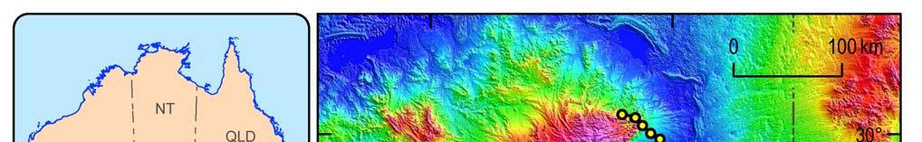
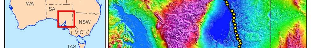
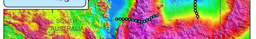
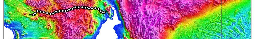
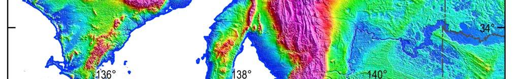
6 GA collaborative SA projects 1. Introduction
7 GA collaborative SA projects 1. Introduction Survey specifications Gawler AuScope (University of Adelaide): Long-period (LP) (3-component Fluxgate, sampling at 10 Hz, bandwidth.1 to.0001 Hz) Broadband (BB) (2-component Lemi induction coils, sampling at 250 Hz, bandwidth 100 to.001 Hz) 12 Long-period sites (20 km spacing) & 24 Broadband sites (10 km spacing) in Broadband sites in 2009, with some repeat and some infill to 5 km 50 m dipole separation Curnamona-Gawler Link AuScope (PIRSA): 15 LP & BB sites, 10 km spacing, 50 m dipole separation in 2009 Curnamona Quantec Geoscience (through Terrex Seismic) (Geoscience Australia): Quantec REF-TEK system 3-component BB, 25 BB sites, 10 km spacing, 100 m dipole separation, bandwidth 250 to.001 Hz, in
 This is a diffusive process, the physics based on Maxwell s equations of electromagnetic induction Measure time changes of E and H at arrays of sites Frequency range 10 KHz")
8 2. MT Theory Passive surface measurement of the Earth s natural electric (E) and magnetic (H) fields Assume planar horizontal magnetic source field (reasonable assumption in mid-latitudes, far from external source regions) This is a diffusive process, the physics based on Maxwell s equations of electromagnetic induction Measure time changes of E and H at arrays of sites Frequency range 10 KHz to.0001 Hz ( s to s) Ratio of E / H used to derive resistivity structure of sub-surface
9 2. MT Theory Why measure resistivity? Igneous Rocks Metamorphic Rocks Dry Sedimentary Rocks Wet Sedimentary Rocks Molten Rock Conductivity mho.m Resistivity Ohm.m Saline Water + Heat Graphite and Sulphides
10 2. MT Theory Depth of Investigation Skin Depth 3 concepts: 1. Low frequencies penetrate deeper than high frequencies 2. High frequencies image the near-surface 3. Signals penetrate further in resistive material Depth Conductive Resistive
11 Source fields 2. MT Theory High frequencies >1 Hz from Spherics, generated by world-wide thunderstorms Low frequencies <1 Hz from Earth s magnetic field variations - solar wind interactions - variations with periods from seconds, minutes, hours, days to yearly cycles (eg. micropulsations, bays, storms) Dead Band 10 1 to 10-1 Hz Power Dead Band 0.1 to 10 s Little energy Skin depths 1.5 to 15 km, upper-middle crust Period (s)
12 Impedance tensor 2. MT Theory Measure two orthogonal components of electric field and two orthogonal components of magnetic field (usually north, x and east, y). Apparent resistivity is determined from their ratios. The magnetotelluric impedance tensor is defined as: Z Z xx yx Z Z xy yy B B x y = E E x y The impedance tensor transfer function values Z are complex values of frequency.
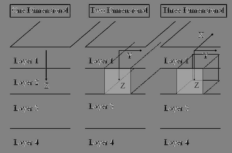
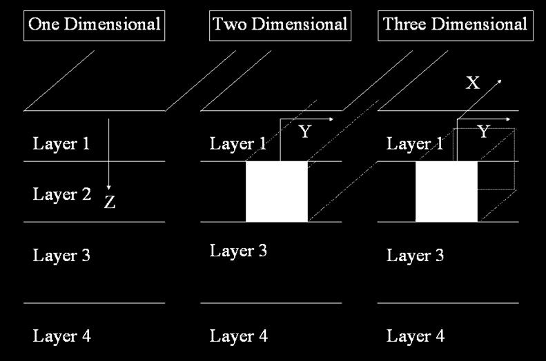
13 Dimensionality 2. MT Theory TE & TM modes
14 2. MT Theory Geomagnetic Depth Sounding Parkinson Arrows Geomagnetic depth sounding relates vertical magnetic field variations to horizontal magnetic field variations Ratios of Z to H are complex functions of period Ratio is always zero for a 1D Earth, so ratio senses 2D & 3D structure Parkinson Arrows point to subsurface electric currents provide lateral information Induced electric current Z Vertical response magnetic field H Horizontal source magnetic field
15 3. Field data acquisition Equipment layout North electrode Quiet Days 7 Days Magnetic Storm Data logger m Central electrode East electrode m Magnetic sensor

16 3. Field data acquisition Induction coils for broadband acquisition - AuScope 1.2 m


17 3. Field data acquisition Fluxgate sensors for long-period acquisition - AuScope Bartington sensor

18 3. Field data acquisition Copper/copper sulphate electrodes - AuScope

 AuScope")

19 3. Field data acquisition Data acquisition systems Quantec REF-TEK system (Curnamona transect) AuScope Earth Data Logger system (Gawler & Curnamona-Gawler Link transects)
20 3. Field data acquisition Field locations Curnamona-Gawler Link transect Gawler transect
21 3. Field data acquisition Example time-series as recorded in the field Gawler transect 21 August 2008 Magnetic N Magnetic E nt Magnetic Z Electric N uv/m Electric E Hours
22 3. Field data acquisition Example time-series as recorded in the field Gawler transect 21 August 2008 Magnetic N Magnetic E Magnetic Z Electric N Record width 30 minutes Electric E
23 4. Processing Processing steps Read data Calibrate Rotate to geographic coords Edit Calculate spectra & impedance tensor components Store in EDI files Calculate apparent resistivity (δ) & phase (θ) from impedance tensor Display δ and θ graphically and as pseudosections Display Parkinson arrows
24 4. Processing Calculation of impedance tensor values (AuScope processing) Time series data are converted to the frequency domain Program BIRRP5 of Alan Chave is publicly available for non-commercial use (Bounded Influence Remote Reference Processing) Remote referencing with other sites (or observatory data) to remove uncorrelated noise For each frequency, the impedance equation is solved for Z with noise in E and B Z Z xx yx Z Z xy yy B B x y = E E x y
25 4. Processing Calculation of Apparent Resistivity & Phase from tensor elements Apparent Resistivity bcf_002 Phase bcf_ LOG RHO (OHM-M) 2 1 PHASE ANGLE (DEG) Curnamona transect example (Quantec Geoscience) RhoXY RhoYX LOG Frequency (Hz) PhsXY PhsYX LOG Frequency (Hz) Tipper Transfer Functions bcf_002 Tipper Transfer Functions bcf_ TRANSFER FUNCTION 0 TRANSFER FUNCTION Txr Txi LOG Frequency (Hz) Tyr Tyi LOG Frequency (Hz)


26 4. Processing Pseudosections of apparent resistivity & phase Curnamona transect example high Apparent resistivity XY Frequency low south north high Phase XY low Section 240 km long
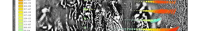
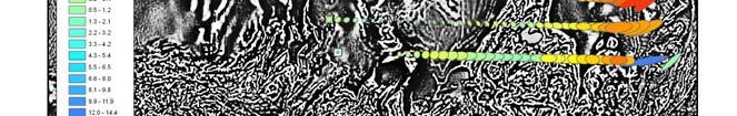
27 Parkinson arrows 4. Processing Curnamona-Gawler Link transect example Lake Torrens high Frequency low 20 km Long-period in-phase arrows (red) and strike symbols (black). Arrows point mainly east to southeast, indicating a current system in that direction (perhaps the Flinders Conductivity Anomaly).
28 Parkinson arrows high 4. Processing Frequency low Curnamona transect example Lake Frome 50 km In-phase arrows (white) and strike symbols (black). Arrows point mainly northeast to east, indicating a current system in that direction (perhaps the Flinders Conductivity Anomaly).
29 5. Analysis Analysis of MT tensor The impedance tensor is the Earth filter, relating E response to H source However, there are complicating factors: Dimensionality of Earth (1D, 2D state of art, 3D in infancy) Strike direction (from impedance tensor and phase tensor if 2D) Static shift Electric field distortion (eg. current channelling) Magnetic field distortion (eg. uniform source field assumption not true) Noise (from various sources, both natural & cultural)

30 5. Analysis Analysis of impedance tensor for dimensionality and strike Rotational invariants of the impedance tensor can be analyzed for dimensionality & strike If a well-defined 2D strike can be determined, then the tensor can be rotated so that the TE mode is parallel to strike, and the TM mode perpendicular to strike. A phase tensor can be defined & presented as an ellipse less subject to distortions 1D High South North Frequency Low Dimensionality example of Curnamona traverse data using WALDIM program

31 Phase tensor ellipses 5. Analysis Gawler transect, 12 long-period responses For periods up to a few 100 s, there is a clear distinction between the western and eastern sites with varying major current flow as depicted by the major orientation of the ellipses. Skew values indicate mostly 2D for periods up to 300 s with increasing complexity for longer periods.


32 Phase tensor ellipses 5. Analysis Curnamona Traverse, 25 BB sites Ellipses coloured by skew
33 6. Modelling Modelling a complex subject 1D forward & inverse are easy and straightforward, but most data not 1D. Good when structures relatively wide compared with depth, such as aquifers & sedimentary basins. 2D forward & inverse codes well-developed, this is state of the art. Resolution best for conductive structures. Can model TE, TM & Hz modes separately or jointly. 3D still mainly in the research phase, codes not generally available, but much of the Earth is 3D! Models can be unconstrained, or constrained by known features, and degree of smoothness controlled The more known rock property information the better Future challenge is joint inversions with seismics, magnetics & gravity, and constraints of structures & properties


34 6. Modelling 1D modelling Bostick transform of Curnamona traverse data TE mode South TM mode North Show major features of data low accuracy


35 2D modelling 6. Modelling Using the Rodie, Mackie finite difference NLCG method as implemented in WinGLink software West Gawler East South Curnamona North
36 7. Conclusions MT data acquired along 3 seismic transects in SA in collaboration with U of A and PIRSA Earth conductivity is complimentary to information from the seismic method, and the MT method has been briefly described Examples of display & analysis of data Analysis confirms major features of Earth conductivity, useful prior to inverse modelling Top of section sediments are well imaged by MT Curnamona data show correlations with interpreted seismic structures, but also reveal other resistive and conductive regions which show no obvious correlations with the seismic data. Also show a response to the Flinders Conductivity Anomaly. Gawler data show a distinct conductive anomaly in the crust in mid-section (perhaps the extension north of the Eyre Peninsula Conductivity Anomaly), and a deeper conductive region in the west Processing and modelling of all three sets of data are on-going results presented here are preliminary

37 Past, Present & Future Work 7. Conclusions
MT Prospecting. Map Resistivity. Determine Formations. Determine Structure. Targeted Drilling
 MT Prospecting Map Resistivity Determine Formations Determine Structure Targeted Drilling Cross-sectional interpretation before and after an MT survey of a mineral exploration prospect containing volcanic
Magnetotelluric (MT) Method
 Method") Magnetotelluric (MT) Method Dr. Hendra Grandis Graduate Program in Applied Geophysics Faculty of Mining and Petroleum Engineering ITB Geophysical Methods Techniques applying physical laws (or theory) to
Magnetotelluric (MT) Method Dr. Hendra Grandis Graduate Program in Applied Geophysics Faculty of Mining and Petroleum Engineering ITB Geophysical Methods Techniques applying physical laws (or theory) to
SUPPLEMENTARY INFORMATION
 SUPPLEMENTARY INFORMATION Supplementary online material for Bai et al., (2). EHS3D MT data collection Broadband magnetotelluric (MT) data were recorded on profiles P, P2 and P4 in the frequency band -.5
APPENDIX A: Magnetotelluric Data in Relation to San Pedro Mesa Structural. The San Pedro Mesa structural high (discussed in main text of paper) was
 was") Page of DR for GSA Special Paper 9, Chapter, Geophysical constraints APPENDIX A: Magnetotelluric Data in Relation to San Pedro Mesa Structural High The San Pedro Mesa structural high (discussed in main
Page of DR for GSA Special Paper 9, Chapter, Geophysical constraints APPENDIX A: Magnetotelluric Data in Relation to San Pedro Mesa Structural High The San Pedro Mesa structural high (discussed in main
A Brief Introduction to Magnetotellurics and Controlled Source Electromagnetic Methods
 A Brief Introduction to Magnetotellurics and Controlled Source Electromagnetic Methods Frank Morrison U.C. Berkeley With the help of: David Alumbaugh Erika Gasperikova Mike Hoversten Andrea Zirilli A few
Monitoring hydraulic stimulation using telluric sounding
 https://doi.org/10.1186/s40623-017-0767-3 FULL PAPER Monitoring hydraulic stimulation using telluric sounding Nigel Rees 1*, Graham Heinson 2 and Dennis Conway 2 Open Access Abstract The telluric sounding
Data Repository Comeau et al., (2015)
") Data Repository 2015087 Comeau et al., (2015) 1. Magnetotelluric data Owing to the remote location, and large distance from sources of electromagnetic noise, most stations were characterized by high quality
Data Repository 2015087 Comeau et al., (2015) 1. Magnetotelluric data Owing to the remote location, and large distance from sources of electromagnetic noise, most stations were characterized by high quality
3D MAGNETOTELLURIC CHARACTERIZATION OF THE COSO GEOTHERMAL FIELD
 PROCEEDINGS, Thirtieth Workshop on Geothermal Reservoir Engineering Stanford University, Stanford, California, January 31-February 2, 2005 SGP-TR-176 3D MAGNETOTELLURIC CHARACTERIZATION OF THE COSO GEOTHERMAL
1D and 2D Inversion of the Magnetotelluric Data for Brine Bearing Structures Investigation
 1D and 2D Inversion of the Magnetotelluric Data for Brine Bearing Structures Investigation Behrooz Oskooi *, Isa Mansoori Kermanshahi * * Institute of Geophysics, University of Tehran, Tehran, Iran. boskooi@ut.ac.ir,
Southern Thomson Magnetotelluric (MT) Survey Report and Data Modelling. Record 2017/03 ecat Liejun Wang, Richard Chopping and Jingming Duan
 Survey Report and Data Modelling. Record 2017/03 ecat Liejun Wang, Richard Chopping and Jingming Duan") Record 2017/03 ecat 90086 Southern Thomson Magnetotelluric (MT) Survey Report and Data Modelling Liejun Wang, Richard Chopping and Jingming Duan APPLYING GEOSCIENCE TO AUSTRALIA S MOST IMPORTANT CHALLENGES
Record 2017/03 ecat 90086 Southern Thomson Magnetotelluric (MT) Survey Report and Data Modelling Liejun Wang, Richard Chopping and Jingming Duan APPLYING GEOSCIENCE TO AUSTRALIA S MOST IMPORTANT CHALLENGES
Gravity-Magnetic & Magneto-Telluric surveys in Purnea Onland Basin, India - A case history.
 P-281 Gravity-Magnetic & Magneto-Telluric surveys in Purnea Onland Basin, India - A case history. Summary A.K. Roy, D.P. Paine*, S. Sett, and H.N. Bhattacharya, ONGC This paper describes a case history
Geological interpretation of seismic. Arrowie Basin, South Australia
 Geological interpretation of seismic reflection lines 08GA-A1 and 09TE-01: Arrowie Basin, South Australia L.K. Carr 1, R.J. Korsch 1, J. Holzschuh 1, Geological R.D. interpretation Costelloe 1, A.J. Meixner
Magnetotelluric and Controlled-Source Electromagnetic Study of Aquistore CO 2 Sequestration Site, near Estevan, Saskatchewan
 Magnetotelluric and Controlled-Source Electromagnetic Study of Aquistore CO 2 Sequestration Site, near Estevan, Saskatchewan Joe, B, McLeod 1, Ian, J, Ferguson 1, Jim Craven 2, Brian Roberts 2, Eric Roots
Carpentaria Electrical Conductivity Anomaly, Queensland, as a major structure in the Australian Plate
 Geol. Soc. Australia Spec. Publ. 22, and Geol. Soc. America Spec. Pap. 372 (2003), 141 156 Carpentaria Electrical Conductivity Anomaly, Queensland, as a major structure in the Australian Plate F. E. M.
Vertical and horizontal resolution considerations for a joint 3D CSEM and MT inversion
 Antony PRICE*, Total E&P and Don WATTS, WesternGeco Electromagnetics Summary To further explore the potential data content and inherent limitations of a detailed 3D Controlled Source ElectroMagnetic and
An Experimental Magnetotelluric Short Sounding During High Sun Spot Activity Cycle in 2013
 Proceedings World Geothermal Congress 2015 Melbourne, Australia, 19-25 April 2015 An Experimental Magnetotelluric Short Sounding During High Sun Spot Activity Cycle in 2013 Lendriadi AGUNG and Imam B.
Geophysics for Environmental and Geotechnical Applications
 Geophysics for Environmental and Geotechnical Applications Dr. Katherine Grote University of Wisconsin Eau Claire Why Use Geophysics? Improve the quality of site characterization (higher resolution and
PUBLISHED VERSION.
 PUBLISHED VERSION S. Thiel, J.R. Peacock, J. MacFarlane and G. Heinson Electromagnetic monitoring of fluid injection - lessons learned Proceedings of the 2012 Australian Geothermal Energy Conference, 2012
A comparison of porosity values inferred from magnetotelluric and bore-hole density data; case studies from two geothermal regions in South Australia
 A comparison of porosity values inferred from magnetotelluric and bore-hole density data; case studies from two geothermal regions in South Australia Thesis submitted in accordance with the requirements
RESISTIVITY IMAGING IN EASTERN NEVADA USING THE AUDIOMAGNETOTELLURIC METHOD FOR HYDROGEOLOGIC FRAMEWORK STUDIES. Abstract.
 RESISTIVITY IMAGING IN EASTERN NEVADA USING THE AUDIOMAGNETOTELLURIC METHOD FOR HYDROGEOLOGIC FRAMEWORK STUDIES Darcy K. McPhee, U.S. Geological Survey, Menlo Park, CA Louise Pellerin, Green Engineering,
G2: what does it mean?
 G2: what does it mean? David Giles Centre for Mineral Exploration Under Cover Discipline of Geology and Geophysics School of Earth and Environmental Sciences The University of Adelaide With thanks to John
Magnetotelluric tensor decomposition: Part II, Examples of a basic procedure
 GEOPHYSICS, VOL. 63, NO. 6 (NOVEMBER-DECEMBER 1998); P. 1898 1907, 5 FIGS. Magnetotelluric tensor decomposition: Part II, Examples of a basic procedure F. E. M. (Ted) Lilley ABSTRACT The decomposition
Geophysical Journal International
 Geophysical Journal International Geophys. J. Int. (2012) 188, 945 958 doi: 10.1111/j.1365-246X.2011.05312.x A simple 2-D explanation for negative phases in TE magnetotelluric data K. Selway, 1 S. Thiel
An Introduction to Geophysical Exploration
 An Introduction to Geophysical Exploration Philip Kearey Department of Earth Sciences University of Bristol Michael Brooks Ty Newydd, City Near Cowbridge Vale of Glamorgan Ian Hill Department of Geology
C5 Magnetic exploration methods data analysis techniques
 C5 Magnetic exploration methods data analysis techniques C5.1 Data processing and corrections After magnetic field data have been collected a number of corrections are applied to simplify the interpretation.
Invariants of rotation of axes and indicators of
 Invariants of rotation of axes and indicators of dimensionality in magnetotellurics F.E.M. Lilley 1 and J.T. Weaver 2 1 Research School of Earth Sciences, Australian National University, Canberra, ACT
Western EARS Geothermal Geophysics Context Mar-2016 William Cumming
 Western EARS Geothermal Geophysics Context Mar-2016 William Cumming Cumming Geoscience, Santa Rosa CA wcumming@wcumming.com Office: +1-707-546-1245 Mobile: +1-707-483-7959 Skype: wcumming.com Kibiro Geophysics
Introducing the Stratagem EH4. Electrical Conductivity Imaging System Hybrid-Source Magnetotellurics
 Introducing the Stratagem EH4 Electrical Conductivity Imaging System Hybrid-Source Magnetotellurics Stratagem EH4 Hybrid-Source Magnetotellurics Frequency range of 10 Hz to 90k Hz Approx. depth of investigation
Magnetic field nomenclature
 Magnetic field nomenclature Declination trend angle between horizontal projection of F and true North Inclination plunge angle between horizontal and F Magnetic equator location on surface where field
MAGNETOTELLURIC INVERSION FOR CHARACTERISATION OF COMPLEX AQUIFER SYSTEMS
 MAGNETOTELLURIC INVERSION FOR CHARACTERISATION OF COMPLEX AQUIFER SYSTEMS Ralf Schaa* Lecturer ralf.schaa@curtin.edu.au Alex Costall PhD Candidate alex.costall@postgrad.curtin.edu.au *presenting author
Exploring for geothermal reservoirs using broadband 2-D MT and gravity in Hungary
 KMS Technologies KJT Enterprises Inc. An EMGS/RXT company Exploring for geothermal reservoirs using broadband 2-D MT and gravity in Hungary Tulinius, H., Adám, L., Halldórsdóttir, H.,Yu, G., Strack, K.
COMPOSITION and PHYSICAL PROPERTIES GENERAL SUBJECTS. GEODESY and GRAVITY
 COMPOSITION and PHYSICAL PROPERTIES Composition and structure of the continental crust Composition and structure of the core Composition and structure of the mantle Composition and structure of the oceanic
Exploration of Geothermal High Enthalpy Resources using Magnetotellurics an Example from Chile
 Exploration of Geothermal High Enthalpy Resources using Magnetotellurics an Example from Chile Ulrich Kalberkamp, Federal Institute for Geosciences and Natural Resources (BGR), Stilleweg 2, 30655 Hannover,
5. Gravity. 5.1 Geoid Variations. The Australian Continent: A Geophysical Synthesis Gravity
 34 The Australian Continent: A Geophysical Synthesis Gravity 5. Gravity Gravity data map subtle changes in the Earth s gravitational field caused by variations in the density of the underlying materials.
Magnetotelluric Array and Magnetic Magnetotelluric Surveys
 Magnetotelluric Array and Magnetic Magnetotelluric Surveys Dr. Wen J Whan JTech Co., Ltd.; wwj@jtech.com.tw Abstract. Surveys using synchronous MT array could further reduce the local noise. Multi variance
3. Radiometry. The Australian Continent: A Geophysical Synthesis Radiometry
 16 3. Radiometry A major effort has been made to assemble a continent-scale study combining the results of many different airborne radiometric surveys (Figure 3.1). The radiometric surveys measure the
Geophysics Course Introduction to DC Resistivity
 NORAD supported project in MRRD covering Capacity Building and Institutional Cooperation in the field of Hydrogeology for Faryab Province Afghanistan Geophysics Course Introduction to DC Resistivity By
RESISTIVITY SURVEYING AND ELECTROMAGNETIC METHODS
 Presented at Short Course VII on Surface Exploration for Geothermal Resources, organized by UNU-GTP and LaGeo, in Santa Tecla and Ahuachapán, El Salvador, March 14-22, 2015. GEOTHERMAL TRAINING PROGRAMME
POTASH DRAGON CHILE GEOPHYSICAL SURVEY TRANSIENT ELECTROMAGNETIC (TEM) METHOD. LLAMARA and SOLIDA PROJECTS SALAR DE LLAMARA, IQUIQUE, REGION I, CHILE
 METHOD. LLAMARA and SOLIDA PROJECTS SALAR DE LLAMARA, IQUIQUE, REGION I, CHILE") POTASH DRAGON CHILE GEOPHYSICAL SURVEY TRANSIENT ELECTROMAGNETIC (TEM) METHOD LLAMARA and SOLIDA PROJECTS SALAR DE LLAMARA, IQUIQUE, REGION I, CHILE OCTOBER 2012 CONTENT Page I INTRODUCTION 1 II FIELD
POTASH DRAGON CHILE GEOPHYSICAL SURVEY TRANSIENT ELECTROMAGNETIC (TEM) METHOD LLAMARA and SOLIDA PROJECTS SALAR DE LLAMARA, IQUIQUE, REGION I, CHILE OCTOBER 2012 CONTENT Page I INTRODUCTION 1 II FIELD
A resolution comparison of horizontal and vertical magnetic transfer functions
 Journal of the Earth and Space Physics, Vol. 40, No. 3, 2014, P. 47-53 A resolution comparison of horizontal and vertical magnetic transfer functions Habibian Dehkordi, B. 1 and Oskooi, B. 2 1 Assitant
Mapping of Mesozoic Sediments below Deccan trap using Magnetotelluric Method.
 P - 364 Mapping of Mesozoic s below Deccan trap using Magnetotelluric Method. Surajit Gorain*(sgorain@gmail.com), Puja Prakash, Dr. Prabhakar Thakur Hindustan Petroleum Corporation Limited Summary Magnetotelluric
SUPPLEMENTARY INFORMATION
 Supplementary Methods Measurement details and instrumentation MT data were recorded using five, GPS-synchronized, 24-bit data-acquisition systems and broadband induction coils manufactured by Phoenix Geophysics
Principles of Applied Geophysics
 Principles of Applied Geophysics Fifth edition D.S. Parasnis Professor emeritus of Applied Geophysics Department of Applied Geophysics, University ofluled, Lulea, Sweden Fellow of the Royal Swedish Academy
Geophysical Investigation of the Old Gaborone Dumpsite, Botswana SHEMANG, E M; MOLWALEFHE, L; CHAOKA, TR; MOSWEU E; NONDO, M
 JASEM ISSN 1119-8362 All rights reserved Full-text Available Online at www.bioline.org.br/ja J. Appl. Sci. Environ. Mgt. September, 2006 Vol. 10 (3) 87-92 Geophysical Investigation of the Old Gaborone
Mapping the basement of South Australia: BACK TO BASICS
 Mapping the basement of South Australia: BACK TO BASICS David Giles Centre for Mineral Exploration Under Cover School of Earth and Environmental Sciences The University of Adelaide The accountants perception
SEAM2: 3D NON-SEISMIC MODELING OF A COMPLEX MIDDLE EAST O&G PROSPECT
 6th International Symposium on Three-Dimensional Electromagnetics Berkeley, California, USA, March 28-3, 217 SEAM2: 3D NON-SEISMIC MODELING OF A COMPLEX MIDDLE EAST O&G PROSPECT M. D. Watts 1, R. L. Mackie
Ophiolite emplacement in NE Oman: constraints from magnetotelluric sounding
 Chapter 4 Ophiolite emplacement in NE Oman: constraints from magnetotelluric sounding 4.1 Foreword This following chapter differs slightly in format compared to the other chapters. The contents represent
Imagerie à l'échelle d'un massif, par méthodes électromagnétiques actives et passives. Liens avec Resif
 Imagerie à l'échelle d'un massif, par méthodes électromagnétiques actives et passives Liens avec Resif Contributeurs: Jean-François Girard (IPGS-EOST, Strasbourg) Stéphane Garambois (ISTerre, Grenoble)
Electrical prospecting involves detection of surface effects produced by electrical current flow in the ground.
 Electrical Surveys in Geophysics Electrical prospecting involves detection of surface effects produced by electrical current flow in the ground. Electrical resistivity method Induced polarization (IP)
Available online Journal of Scientific and Engineering Research, 2016, 3(2):1-7. Research Article
:1-7. Research Article") Available online www.jsaer.com, 2016, 3(2):1-7 Research Article ISSN: 2394-2630 CODEN(USA): JSERBR Assessment of the Reliability of Magnetic Method to Delineate Geologic Features in a Basement Complex:
Available online www.jsaer.com, 2016, 3(2):1-7 Research Article ISSN: 2394-2630 CODEN(USA): JSERBR Assessment of the Reliability of Magnetic Method to Delineate Geologic Features in a Basement Complex:
. Slide 1. Geological Survey of Ethiopia, P.O.Box 2302, Addis Ababa, Ethiopia
 The electrical resistivity structure of the Southern Main Ethiopian Rift (around the Lake Abaya geothermal prospect) revealed by magneto-telluric telluric imaging Mohammednur Desissa and Yohanes Lema Geological
Effects of galvanic distortions on magnetotelluric data: Interpretation and its correction using deep electrical data
 Effects of galvanic distortions on magnetotelluric data: Interpretation and its correction using deep electrical data Jimmy Stephen 1, S G Gokarn 2, C Manoj 1 and S B Singh 1 1 National Geophysical Research
MT as a tool for geothermal exploration: a case study from Southern Tuscany
 European Geothermal Congress 2013 Pisa, Italy, 3 7 June 2013 MT as a tool for geothermal exploration: a case study from Southern Tuscany Giorgio Buonasorte 1, Ricardo Caranova 2, Adolfo Fiordelisi 1, Carlo
M.Sc. Thesis. Author: Merijn de Block
 M.Sc. Thesis An alternative method for estimating the porosity and the permeability of (potential) geothermal reservoirs using magnetotelluric data; A case study of the Sherwood Sandstone Group in the
INTRODUCTION TO APPLIED GEOPHYSICS
 INTRODUCTION TO APPLIED GEOPHYSICS EXPLORING THE SHALL0W SUBSURFACE H. Robert Burger Anne F. Sheehan Craig H.Jones VERSITY OF COLORADO VERSITY OF COLORADO W. W. NORTON & COMPANY NEW YORK LONDON Contents
15. MATHEMATICAL ALGORITHMS
 15. MATHEMATICAL ALGORITHMS 15.1 STANDARD ERROR OF THE MEAN (SEM)... 2 15.2 3-POINT DECOUPLING... 3 15.3 A NOTE ON RESISTIVITY CALCULATIONS... 4 15.4 RESISTIVITY CALCULATIONS... 4 DIPOLE - DIPOLE...4 POLE
For personal use only
 25 th June 2018 ASX MARKET RELEASE ASX: AMG AUSMEX COMMENCES MT SURVEY OVER LARGE CONDUCTIVE STRUCTURE BELOW BURRA, SA Ø AUSMEX (AMG) AND UNIVERSITY OF ADELAIDE (UoA) IN COLLABORATION WITH OTHERS (SEE
RESISTIVITY STRUCTURE OF PAKA GEOTHERMAL PROSPECT IN KENYA
 GEOTHERMAL TRAINING PROGRAMME Reports 2011 Orkustofnun, Grensasvegur 9, Number 26 IS-108 Reykjavik, Iceland RESISTIVITY STRUCTURE OF PAKA GEOTHERMAL PROSPECT IN KENYA Raymond M. Mwakirani Geothermal Development
Darnley Bay Resources Preliminary Airborne Survey Results
 4 King Street West, Suite 1103 Toronto, Ontario M5H 1B6, Canada Tel:(416) 862-7885 Fax:(416) 862-7889 dbr@darnleybay.com UPDATE Trading Symbol: DBL. TSX Venture Exchange April 19, 2010 Darnley Bay Resources
Exploring for geothermal reservoirs using broadband 2-D MT and gravity in Hungary
 KMS Technologies KJT Enterprises Inc. An EMGS/RXT company Exploring for geothermal reservoirs using broadband 2-D MT and gravity in Hungary Tulinius, H., Adám, L., Halldórsdóttir, H.,Yu, G., Strack, K.
Hendra Grandis 1 and Prihadi Sumintadireja 2
 A BRIEF REVIEW FOR THE PROPER APPLICATION OF MAGNETOTELLURIC (MT) AND CONTROLLED-SOURCE AUDIO-FREQUENCY MAGNETOTELLURIC (CSAMT) IN GEOTHERMAL EXPLORATION Hendra Grandis 1 and Prihadi Sumintadireja 2 ABSTRACT
Constraints from magnetotellurics on the subsurface structure and emplacement of the Mourne Granites
 Laura A. Ayres Constraints from magnetotellurics on the subsurface structure and emplacement of the Mourne Granites 2011 Earth Sciences, School of Geography, Earth & Environmental Sciences, University
3D potential-field inversions and alteration mapping in the Gawler Craton and Curnamona Province, South Australia
 3D potential-field inversions and alteration mapping in the Gawler Craton and Curnamona Province, South Australia Richard Chopping, Nick Williams, Tony Meixner and Indrajit Roy Outline Inversions Introduction
September 16, 2010 Magnetic surveying
 September 16, 2010 Magnetic surveying After today, you will be able to Sketch anomalies over objects at any location, and explain how you derived the pattern. Explain the relation between dipoles and real
Department of Geophysics Faculty of Earth Sciences King Abdulaziz University
 Department of Geophysics Faculty of Earth Sciences King Abdulaziz University Dr. Mansour A. Al-Garni Office: room 233/Buld. 27 OR Dept. chair office/buld. 55 Introduction to Geophysics EGP 211 Time: 10-10:55
Magnetotelluric Method. Stephen Park IGPP UC Riverside
 Magnetotelluric Method Stephen Park IGPP UC Riverside magneto@ucrmt.ucr.edu So, what is the magnetotelluric method? The magnetotelluric (MT) method determines the tensor electrical impedance of the earth
Appendix B: Geophysical Data (Thesis Appendix, 2013)
") Utah State University From the SelectedWorks of David J Richey 2013 Appendix B: Geophysical Data (Thesis Appendix, 2013) David J Richey, Utah State University Available at: https://works.bepress.com/david_richey/2/
Utah State University From the SelectedWorks of David J Richey 2013 Appendix B: Geophysical Data (Thesis Appendix, 2013) David J Richey, Utah State University Available at: https://works.bepress.com/david_richey/2/
Resistivity structure of Sumikawa geothermal field, northeastern Japan, obtained from magnetotelluric data. Toshihiro Uchida
 Resistivity structure of Sumikawa geothermal field, northeastern Japan, obtained from magnetotelluric data Toshihiro Geological Survey of Japan 1-1-3 Higashi, Tsukuba, Ibaraki 35, Japan ABSTRACT: Resistivity
EXTREMELY FAST IP USED TO DELINEATE BURIED LANDFILLS. Norman R. Carlson, Cris Mauldin Mayerle, and Kenneth L. Zonge
 EXTREMELY FAST IP USED TO DELINEATE BURIED LANDFILLS Norman R. Carlson, Cris Mauldin Mayerle, and Kenneth L. Zonge Zonge Engineering and Research Organization, Inc. 3322 East Fort Lowell Road Tucson, Arizona,
Uranium deposit types: a systems perspective
 Uranium deposit types: a systems perspective Roger Skirrow Onshore Energy & Minerals Division roger.skirrow@ga.gov.au Outline 1. A new view of U deposit types: 3 families of mineral systems 2. Concepts
Earthquake patterns in the Flinders Ranges - Temporary network , preliminary results
 Earthquake patterns in the Flinders Ranges - Temporary network 2003-2006, preliminary results Objectives David Love 1, Phil Cummins 2, Natalie Balfour 3 1 Primary Industries and Resources South Australia
Downloaded 08/29/13 to Redistribution subject to SEG license or copyright; see Terms of Use at
 New approach to 3D inversion of MCSEM and MMT data using multinary model transform Alexander V. Gribenko and Michael S. Zhdanov, University of Utah and TechnoImaging SUMMARY Marine controlled-source electromagnetic
Comparison of geophysical. techniques to determine depth to. bedrock in complex weathered. environments of the Mount Crawford. region, South Australia
 Comparison of geophysical techniques to determine depth to bedrock in complex weathered environments of the Mount Crawford region, South Australia Thesis submitted in accordance with the requirements of
Z i = a X i + b Y i + r i (1) 22. Kolloquium Elektromagnetische Tiefenforschung, Hotel Maxičky, Děčín, Czech Republic, October 1-5,
 22. Kolloquium Elektromagnetische Tiefenforschung, Hotel Maxičky, Děčín, Czech Republic, October 1-5,") MT Robust Remote Reference Processing revisited Thomas Krings 1,2, Oliver Ritter 2, Gerard Muñoz 2, Ute Weckmann 2 1 Westfälische Wilhelms-Universität Münster 2 GeoForschungsZentrum Potsdam contact: t
MT Robust Remote Reference Processing revisited Thomas Krings 1,2, Oliver Ritter 2, Gerard Muñoz 2, Ute Weckmann 2 1 Westfälische Wilhelms-Universität Münster 2 GeoForschungsZentrum Potsdam contact: t
2017 Fowler Domain & Western Gawler Craton SkyTEM 312 AEM Survey, South Australia
 2017 Fowler Domain & Western Gawler Craton SkyTEM 312 AEM Survey, South Australia Geoscience Australia & the Geological Survey of South Australia D.J McInnes Geoscience Australia ecat ID 121550 Department
Characterizing a geothermal reservoir using broadband 2-D MT survey in Theistareykir, Iceland
 KMS Technologies KJT Enterprises Inc. An EMGS/RXT company Characterizing a geothermal reservoir using broadband 2-D MT survey in Theistareykir, Iceland Yu, G., Strack, K. M., Allegar, N., Gunnarsson, Á.
MAGNETOTELLURIC RESISTIVITY IMAGING OVER THE KAWENGAN OIL FIELD AND BANYUASIN PROSPECT, NORTH EAST JAVA BASIN
 MAGNETOTELLURIC RESISTIVITY IMAGING OVER THE KAWENGAN OIL FIELD AND BANYUASIN PROSPECT, NORTH EAST JAVA BASIN Hendra Grandis 1, Djedi S. Widarto 2, Edi P. Utomo 2, Waluyo 3, and Fred Hehuwat 2 2 Department
Electronic Geophysical Surveys LirJted, 250 South Fell Avenue, North Burnahy 2, B. C. Telenhone:
 L GEOWG GEOPIIYSICAL SEPORT #IlO of the Gaichon Contact Group of Claims!. 1 mile NNbJ of Max&$ Lake, B.C. 50 North - 120 Vest for 4": "~ II' George Saarse Aup,,. 12 - Aug. 29, 1964 D. L. Hings, P. Eng.
SEG Houston 2009 International Exposition and Annual Meeting
 The role of EM rock physics and seismic data in integrated 3D CSEM data analysis I. Brevik*, StatoilHydro, Pål T. Gabrielsen, Vestfonna and Jan Petter Morten, EMGS Summary An extensive 3D CSEM dataset
Geodynamic implications of the GOMA deep seismic reflection line (08GA-OM1)
") Geodynamic implications of the GOMA deep seismic reflection line (08GA-OM1) Russell Korsch 1, N. Kositcin 1, R. Blewett 1, G. Fraser 1, G. Baines 2, B. Kennett 3, N. Neumann 1, A. Reid 4, W. Preiss 4,
Geodynamic implications of the GOMA deep seismic reflection line (08GA-OM1) Russell Korsch 1, N. Kositcin 1, R. Blewett 1, G. Fraser 1, G. Baines 2, B. Kennett 3, N. Neumann 1, A. Reid 4, W. Preiss 4,
Magnetotelluric measurements for determining the subsurface salinity and porosity structure of Amchitka Island, Alaska
 Appendix 6.A Magnetotelluric measurements for determining the subsurface salinity and porosity structure of Amchitka Island, Alaska Martyn Unsworth, Wolfgang Soyer and Volkan Tuncer Department of Physics
UTEM Electric Field Measurements
 UTEM Electric Field Measurements first measurements by Y. Lamontagne ~1975 (U of T) Ph.D. studies (U of T) by J. Macnae confirmed the method ISR evolved ~ 1986 for gold exploration (sillicification) clients
Quantec s ORION 3D System Application and Examples
 Quantec s ORION 3D System Application and Examples Warren W. Stanyer David Thomson Michele Tuomi Roger Sharpe*, Kevin Killin Nevada Sunrise Cerro Grande Mining Landore Resources Canada Quantec Geoscience
Magnetotelluric Survey in an Extremely Noisy Environment at the Pohang Low-Enthalpy Geothermal Area, Korea
 Proceedings World Geothermal Congress 2005 Antalya, Turkey, 24-29 April 2005 Magnetotelluric Survey in an Extremely Noisy Environment at the Pohang Low-Enthalpy Geothermal Area, Korea Toshihiro Uchida
Lesson 1 Introduction to geophysical methods Emanuele Forte
 Lesson 1 Introduction to geophysical methods Emanuele Forte 3 rd September 2016 Naxos, Greece 1 Outline - What is Geophysics - Base concepts: (Geo)Physical parameters Sensitivity Resolution - Active and
Marine EM on Land: MT Measurements in Mono Lake. Steven Constable, UCSD/SIO Jared Peacock, USGS EMIW 2018
 Marine EM on Land: MT Measurements in Mono Lake Steven Constable, UCSD/SIO Jared Peacock, USGS EMIW 218 Mono Lake sits in the Mono Basin, where the Basin and Range meets the Sierra Nevada. The Sierra Nevada
Monthly Magnetic Bulletin
 BRITISH GEOLOGICAL SURVEY Port Stanley Observatory Monthly Magnetic Bulletin July 2011 11/07/PS Jason Islands West Falkland King George Bay Queen Charlotte Bay Weddell Island Caracass Island Saunders Island
Lecture #13 notes, Geology 3950 Spring 2006: CR Stern Magnetic reversals (text pages th edition and in the 5 th edition)
") Lecture #13 notes, Geology 3950 Spring 2006: CR Stern Magnetic reversals (text pages 35-37 4 th edition and 53-55 in the 5 th edition) The earth has a magnetic field generated by circulation of charged
Lecture #13 notes, Geology 3950 Spring 2006: CR Stern Magnetic reversals (text pages 35-37 4 th edition and 53-55 in the 5 th edition) The earth has a magnetic field generated by circulation of charged
Geomagnetic induction in the Tasman Sea and electrical conductivity structure beneath the Tasman Seafloor
 Geophys. J. Int. (1990) 102, 299-312 Geomagnetic induction in the Tasman Sea and electrical conductivity structure beneath the Tasman Seafloor I. J. Ferguson," F. E. M. Lilley and J. H. Fillouxt Research
Interpretation Report on Borehole TDEM Surveys
 Interpretation Report on Borehole TDEM Surveys Junior Lake Property, Armstrong, Ontario For Landore Resources Canada Inc. Alan R. King, M.Sc., P.Geo. January 25, 2016 Introduction Alan King of Geoscience
The advantages of complementing MT profiles in 3- D environments with. geomagnetic transfer function and inter- station horizontal magnetic transfer
 Page of The advantages of complementing MT profiles in - D environments with geomagnetic transfer function and inter- station horizontal magnetic transfer function data: Results from a synthetic case study
Electromagnetic Induction by Ocean Currents and the Conductivity of the Oceanic Lithosphere
 J. Geomag. Geoelectr., 35, 491-499, 1983 Electromagnetic Induction by Ocean Currents and the Conductivity of the Oceanic Lithosphere Alan D. CHAVE* and Charles. S. Cox** *Institute of Geophysics and Planetary
Geophysics for Geothermal Exploration
 Geophysics for Geothermal Exploration Dr. Hendra Grandis Geofisika - ITB Agenda Basic concept of Geophysics: : Review Geophysical signatures of a geothermal system Geophysical methods for geotermal exploration
Geophysical Journal International
 Geophysical Journal International Geophys. J. Int. (2013) 195, 1576 1593 Advance Access publication 2013 October 7 doi: 10.1093/gji/ggt355 GJI Geomagnetism, rock magnetism and palaeomagnetism A novel anisotropic
Identified a possible new offset location where the customer is currently exploring drill options.
 GroundMetrics was hired to conduct a Full-Field Resistivity Survey for an oil and gas producer that needed to make crucial decisions to drive profitability at the location. The results saved them hundreds
ECEN 615 Methods of Electric Power Systems Analysis Lecture 23: Geomagnetic Disturbances, Optimal Power Flow
 ECEN 615 Methods of Electric Power Systems Analysis Lecture 23: Geomagnetic Disturbances, Optimal Power Flow Prof. Tom Overbye Dept. of Electrical and Computer Engineering Texas A&M University overbye@tamu.edu
Geothermal Energy Resources Exploration using Gravity and magnetics. By Mariita, N.O. KenGen
 Geothermal Energy Resources Exploration using Gravity and magnetics By Mariita, N.O. KenGen What is Geothermal Energy? Geothermal Energy = heat from the Earth Transmitted by fluids via fractures and pores
Integrated Geophysical Model for Suswa Geothermal Prospect using Resistivity, Seismics and Gravity Survey Data in Kenya
 Proceedings World Geothermal Congress 2015 Melbourne, Australia, 19-25 April 2015 Integrated Geophysical Model for Suswa Geothermal Prospect using Resistivity, Seismics and Gravity Survey Data in Kenya
For personal use only
 ASX ANNOUNCEMENT 31 AUGUST 2015 HIGH POWERED EM SURVEY AND DRILLING PLANNED AT TWO IDENTIFIED NICKEL PROSPECTS, FRASER RANGE WA HIGHLIGHTS 60km of High powered EM (HPEM) survey due to commence at Plato
Magnetotelluric constraints on the fluid content in the upper mantle beneath the southern Canadian Cordillera: Implications for rheology
 JOURNAL OF GEOPHYSICAL RESEARCH: SOLID EARTH, VOL. 8, 24, doi:.2/jgrb.5255, 23 Magnetotelluric constraints on the fluid content in the upper mantle beneath the southern Canadian Cordillera: Implications