Mount St. Helens changed the way we look at things!
|
|
|
- Martin Welch
- 6 years ago
- Views:
Transcription


1 Mount St. Helens, a turning point in studies of, and perceptions about explosive volcanoes Mount St. Helens changed the way we look at things! Plinian column during the cataclysmic eruption of May 18, 1980 Pat Pringle Centralia College View to the north-northwest after noon; photo by Bob Krimmel, I m grateful to Keith Ronholm, Cathie Hickson, Fred Swanson, and Lisa Faust for use of selected images USGS Photo by Claude Palmer, 1937, courtesy of Photo Art Studios. Looks SSW across Spirit Lake. Native American legends and geologic evidence can tell us about prehistoric eruptions. Pahto (Mount Adams) and Wy-east (Mount Hood) fought over a young maiden, Loo-wit Lat-kla An eruption from the Goat Rocks dome as painted by Paul Kane in 1847 Don Lawrence, tree-ring pioneer in the NW SET C first effort to date postglacial eruptive products of Mount St. Helens MSH SET P MSH SET Y B F D Mazama Lawrence & Lawrence, 1959 Photo by Don Mullineaux; Tephra in Ohanapecosh Park at MountRainier the evidence for Mount St. Helens explosive past is first recognized in MSH pumice found at Mount Rainier by Don Mullineaux


2 Clynne, M, 2005 USGS Fact Sheet the Yn tephra changed settlement patterns in the SW Washington Cascade Range for more than 1700 years! Rick McClure, USFS Volcano Hazard Map we we ve learned a great deal from the modern eruptions of Mount St. Helens Goat Mtn.~220 ka Pine Creek deposits, ~3 2.5 ka 2.8 ka breaching of debris-dammed lakes ~20 ka lava flow oldest exposed rock on MSH USGS geologist Kevin Scott exams deposits of humongous ancient lahars 50 km downstream of Mount St. Helens Mount St. Helens 1980 Crater Ape Canyon ka ka Cougar ka Swift Creek ka Spirit Lake ka Clynne, 2005; Clynne et al., 2008; Mullineaux and Crandell, ~2.8 ka debris avalanche deposits that blocked the lakes!! Eruptive History


3 Small phreatic eruption on May 11, 1980; view to south; dashed area is deforming. WA Div. of Geology photo of Mount St. Helens, March 30, 1980, Mount Adams to right (east) Mount St. Helens allowed a visualization of volcanic processes that people could transpose to other stratovolcanoes Mount St. Helens May 18, 1980, seconds after the beginning of the eruption. Photo by Gary Rosenquist from Bear Meadow, ~11 km northeast of the volcano. Photo by Keith Ronnholm; ~13 sec after eruption start Photo by Keith Ronnholm; ~31 sec after eruption start


4 copyrighted photo by Keith Ronnholm Eye-witness photos by Paul and Cathie Hickson Photos by Paul and Cathie Hickson from the east, 5/18/80 Photo by Keith Ronnholm copyrighted photo by Gary Rosenquist


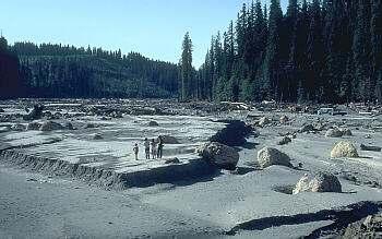
5 Mount St. Helens Plinian column during the cataclysmic eruption of May 18, 1980 View to the north-northwest after noon; photo by Bob Krimmel, USGS Photo by Paul and Cathie Hickson Lahar Effects Erosion Burial Impact Altered channels Montserrat Volcano Observatory Blowdown Blast Zone Hummocky 1980 debris-avalanche deposit of Mount St. Helens as seen from the Hummocks Trail, about 9 km from the volcano.


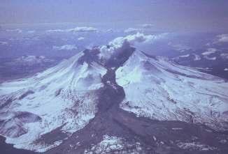
6 Mudflow Pyroclastic flow of August 7, 1980 at Mount St. Helens Pumiceous pyroclastic flow deposit; >700 deg C early dome formation, summer 1980 Some domes survived! December

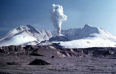
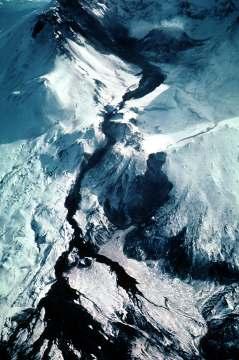
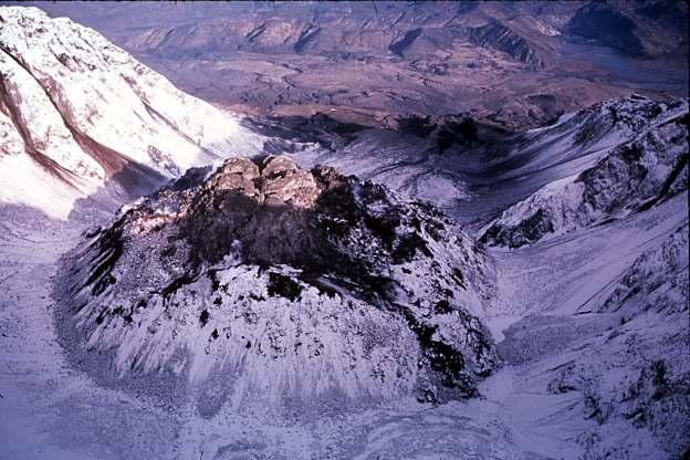
7 Lahar Hazards Origin Eruption-induced induced melting of ice and snow Debris avalanche Lake breakout Erosion of tephra and other sediments March 19, 1982 lahar March 29, 1984, ~4 AM May 14, 1984 explosion and lahar! Ken Cameron photos photo by Jack Hash October 26, 1986, final extrusion of lava for the dome A glacier s birth, 1990s


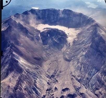
8 Daryll Lloyd photo of east terminus of the Crater Glacier The volume of the new lava dome as measured July 5, 2007, was 122 million cubic yards (volume is equivalent to 150 to 200 large sports stadiums) and was growing at an average rate of 0.14 cubic yards per second (nearly equivalent to filling 4 Olympic-sized swimming pools every day. [Information release, February 21, 2008]


")


9 Mount St. Helens Erosion reveals longburied deposits & buried trees: amazing opportunities to study the past Societal Unrest Wn late AD 1479 We ~AD 1482 X ~AD T Agency control Sediment control Fish and game Public access ~AD 1800 Floating Island Lava ~AD1800 Goat Rx dome ~AD Dave Yamaguchi, 1980s(many papers) *Kalama Eruptive Period AD 1480 to mid 1700s *Goat Rocks Eruptive Pd. AD 1800 to ~1859 Advancing Earth Sciences -Poorly known processes Orting Electron Mudflow ~A.D New Tools, New Deployments, Sensor Arrays Nevada del Ruiz Service to Society -USGS Volcano Disaster Assistance Program


10 Mount St. Helens, a natural learning and research laboratory
Debris Avalanches. Debris avalanche deposits on a volcano in Chile. All of the area in the foreground is buried by a thick debris avalanche.
 Debris Avalanches Volcanoes are not very stable structures. From time to time, they collapse producing large rock and ash avalanches that travel at high speeds down valleys. Collapse maybe caused by an
GEOLOGY 285: INTRO. PETROLOGY
 Dr. Helen Lang Dept. of Geology & Geography West Virginia University FALL 2005 GEOLOGY 285: INTRO. PETROLOGY Mount St. Helens 1980 Eruption Small earthquakes Small steam and ash eruptions in March and
GEOLOGY 285: INTRO. PETROLOGY
 Dr. Helen Lang Dept. of Geology & Geography West Virginia University SPRING 2015 GEOLOGY 285: INTRO. PETROLOGY The Cascade Volcanoes are a good example of the Circum- Pacific ring of fire of subductionrelated
Why was this eruption important?
 Mount St. Helens Mount St. Helens has a long geological history (>3,000 yrs) of explosive eruptions. The 1980 Events: Initial relatively mild steam and ash (Vulcanian) eruptions. Sustained plinian eruption
What mainly controls eruptive style?
 Introduction to volcanoes, volcanic eruptions, and volcanic landforms Previous: Magmatic differentiation, Bowens Reaction series (mineral melting points), mafic vs. felsic (fluid vs. sticky) Video: Lava
3/7/17. #16 - Case Studies of Volcanoes II. Announcements Monday 2/27
 Announcements Monday 2/27 Exam #1: Monday Feb. 27 th, 7:15-8:15 (see web site) Last Names A - N Loomis 141 Last Names O - Z Loomis 151 Bring your student ID An old exam is posted in Compass If you are
Mount St. Helens. Copyright 2010 LessonSnips
 Mount St. Helens Washington State is home to the Cascade Mountains, a range of mountains that extends from the Canadian province of British Columbia to northern California. Many of these mountains are
Mt St Helens was know to have entered into active periods that lasted from years once every years over the last 500 years, (Figure 5).
.") Lecture #8 notes; Geology 3950, Spring 2006; CR Stern May 1980 eruption of Mt St Helens volcano (text pages 183-192 in the 4 th edition and 206-222 in the 5 th edition) Mt St Helens in southwest Washington
Lecture #8 notes; Geology 3950, Spring 2006; CR Stern May 1980 eruption of Mt St Helens volcano (text pages 183-192 in the 4 th edition and 206-222 in the 5 th edition) Mt St Helens in southwest Washington
Case History: Mt. St. Helens
 Case History: Mt. St. Helens EAS 458 Volcanology Introduction 1980 eruption of Mt. St. Helens was particularly interesting and violent eruption with an unusual lateral blast. In the 1970 s, the USGS (Crandell(
The Orting Community College of Vulcanology
 The Orting Community College of Vulcanology A Recommendation For His Honourable Mayor A. Young By DAG (Doom-and-Gloom), LLP (Michael, Chris, Bryan, Lauren, Dave) Agenda 1. 2. 3. 4. 5. 6. Description of
From Punchbowl to Panum: Long Valley Volcanism and the Mono-Inyo Crater Chain
 From Punchbowl to Panum: Leslie Schaffer E105 2002 Final Paper Long Valley Volcanism and the Mono-Inyo Crater Chain Figure 1. After a sequence of earthquakes during the late 1970 s to the early 1980 s
A New College in Orting?
 A New College in Orting? Risk Report and Recommendation by: Safe Schools Kause Everyone Deserves (SSKED) 2017 Geographic location and physical site of Orting The city of Orting is located in Pierce county,
Orting Community College Proposal
 Orting Community College Proposal Cedric, Celina, Francine, Sarah, Samuel GEO CORP Located in Washington, 42 miles south of Seattle. Situated between two rivers on fertile plains. Built on lahar deposits.
Volcanoes. Environmental Geology, Mr. Paul Lowrey Stacey Singleton, Cassandra Combs, Dwight Stephenson, Matt Smithyman
 Volcanoes Environmental Geology, Mr. Paul Lowrey Stacey Singleton, Cassandra Combs, Dwight Stephenson, Matt Smithyman EMPACTS Project, Spring 2017 Northwest Arkansas Community College, Bentonville, AR
Hazards in the Seattle Area. Disaster Questions. Where Were You? Where Were You? Volcanoes St. Helens Adams, Rainier, Glacier, Baker
 Hazards in the Seattle Area Volcanoes St. Helens Adams, Rainier, Glacier, Baker Earthquakes Outer coast Puget Sound (Seattle Fault & others) Tsunami Outer coast Puget Sound (Seattle Fault & others) Disaster
GEOL1 Physical Geology Laboratory Manual College of the Redwoods Lesson Five: Volcanoes Background Reading: Volcanoes Volcanic Terms: Silca:
 Name: Date: GEOL1 Physical Geology Laboratory Manual College of the Redwoods Lesson Five: Volcanoes Background Reading: Volcanoes Volcanic Terms: Silca: SiO 2 silicon dioxide. This is quartz when it crystallizes.
Stop that Sediment! Create a plan to help the people that work, live, and play by the Toutle River
 Stop that Sediment! Create a plan to help the people that work, live, and play by the Toutle River The 1980 eruption began with an enormous landslide. As far as we know, this landslide was the largest
GLG Ch 6: Volcanoes & Volcanic Hazards. 3. Name, describe (DSC) and draw the three types of volcanoes from smallest to largest.
 and draw the three types of volcanoes from smallest to largest.") GLG 101 - Ch 6: Volcanoes & Volcanic Hazards Name 6.1 What Is and and Is Not a Volcano? 1. Three common characteristics of a volcano include A B C 2. How did the Hopi Buttes (figure 06 01.b1) form? 3.
GLG 101 - Ch 6: Volcanoes & Volcanic Hazards Name 6.1 What Is and and Is Not a Volcano? 1. Three common characteristics of a volcano include A B C 2. How did the Hopi Buttes (figure 06 01.b1) form? 3.
The Ongoing Eruption of Mount St. Helens* By Thomas C. Pierson 1
 The Ongoing Eruption of Mount St. Helens* By Thomas C. Pierson 1 Search and Discovery Article #50042 (2007) Posted May 12, 2007 *Abstract of presentation to Tulsa Geological Society, April 24, 2007, followed
GEO 305: LIVING WITH ACTIVE CASCADE VOLCANOES SUMMER 2002 (7/22 8/15) COURSE SYLLABUS. Faculty Contact: Instructor, Summer 2002:
 COURSE SYLLABUS. Faculty Contact: Instructor, Summer 2002:") GEO 305: LIVING WITH ACTIVE CASCADE VOLCANOES SUMMER 2002 (7/22 8/15) COURSE SYLLABUS Faculty Contact: Instructor, Summer 2002: Roger Nielsen Heather Petcovic Geology Program Director Office Dawes 21 Dept.
GEO 305: LIVING WITH ACTIVE CASCADE VOLCANOES SUMMER 2002 (7/22 8/15) COURSE SYLLABUS Faculty Contact: Instructor, Summer 2002: Roger Nielsen Heather Petcovic Geology Program Director Office Dawes 21 Dept.
HAZARD IDENTIFICATION AND VULNERABILITY ANALYSIS (HIVA) Walla Walla County, Washington VOLCANO ASH FALL
 Walla Walla County, Washington VOLCANO ASH FALL") HAZARD IDENTIFICATION AND VULNERABILITY ANALYSIS (HIVA) Walla Walla County, Washington VOLCANO ASH FALL Hazard Overview A volcano is a vent in the earth's crust through which magma (molten rock), rock
HAZARD IDENTIFICATION AND VULNERABILITY ANALYSIS (HIVA) Walla Walla County, Washington VOLCANO ASH FALL Hazard Overview A volcano is a vent in the earth's crust through which magma (molten rock), rock
Clough Award 2017 Katmai and the Valley of Ten Thousand Smokes
 Clough Award 2017 Katmai and the Valley of Ten Thousand Smokes In June 2017, Clough Award funding allowed me to participate in the International Volcanology Summer School, organised by University of Alaska
Homework III. Volcanological Exercises
 Page 1 of 5 EENS 3050 Tulane University Natural Disasters Prof. Stephen A. Nelson Homework III. Volcanological Exercises This page last updated on 16-Feb-2018 1. In your work as an insurance company executive
Volcanic Deformation and Evolution.
 Volcanic Deformation and Evolution of Mt. Saint SitHelens http://pubs.usgs.gov/sim/3008/ B. A. Digital perspective view derived from USGS Digital Elevation Model (DEM) of Mount St. Helens as seen from
Fire and Ice. Overview. Grade Level 6 8. Students will be able to: Objectives
 Fire and Ice Overview Students use a power point presentation to compare and contrast the geologic history and environment of Mount Rainier and Mount Fuji, the Sister Mountains. Grade Level 6 8 Students
WHEN IS A SURGE NOT A SURGE? THAT IS THE PERPLEXING QUESTION. (for emergency managers)
") WHEN IS A SURGE NOT A SURGE? THAT IS THE PERPLEXING QUESTION (for emergency managers) Mount St Helens, May 18, 1980 37 years, 5 months, and 6 days ago.. Eyewitnesses there were many! Rosenbaum and Waitt,
WHEN IS A SURGE NOT A SURGE? THAT IS THE PERPLEXING QUESTION (for emergency managers) Mount St Helens, May 18, 1980 37 years, 5 months, and 6 days ago.. Eyewitnesses there were many! Rosenbaum and Waitt,
Erupted and killed approximately 15,000 people 200 years ago
 1 2 3 4 5 6 7 8 Introduction to Environmental Geology, 5e Chapter 8 Volcanic Activity Volcanoes: summary in haiku form A volcano forms. Magma comes to the surface - explodes, if felsic. Case History: Mt.
Study Guide: Unit 3. Density and Pressure: You should be able to answer the types of questions given in the end of module questions.
 IDS 102 Study Guide: Unit 3 The purpose of this study guide is to help you prepare for the third exam by focusing your studying and providing example essay questions. In the Focus On section you will find
Volcanoes. 11/25/2013. Geology 15 Lecture 27 VOLCANO!
 Hazard Update Surprise POP Review Tsunami Activity 10 B Today s Material Volcanoes Volcanic Hazards Geology 15 Lecture 27 VOLCANO! http://motherboard.vice.com/blog/watch an erupting volcano create a newisland
Released Science Inquiry Task Encounter with an Active Volcano Grade 11
 Date: Your Name: Released Science Inquiry Task Encounter with an Active Volcano 2016 Grade 11 Directions: Science You will be reading a story and analyzing the data provided to answer a set of questions.
Patterns of Recovery Outdoor Activity
 Mount St Helens National Volcanic Monument Teacher s Corner 2011 Gifford Pinchot National Forest USDA Forest Service Patterns of Recovery Outdoor Activity Time Commitment: Site: Location: 45 minutes to
FIRST GRADE HAZARDS 1 WEEK LESSON PLANS AND ACTIVITIES
 FIRST GRADE HAZARDS 1 WEEK LESSON PLANS AND ACTIVITIES PLATE TECTONIC CYCLE OVERVIEW OF FIRST GRADE VOLCANOES WEEK 1. PRE: Learning the shapes of volcanoes. LAB: Experimenting with "lava." POST: Comparing
2/25/2013. Volcanoes: summary in haiku form A volcano forms. Magma comes to the surface - explodes, if felsic.
 Introduction to Environmental Geology, 5e Edward A. Keller Chapter 8 Volcanic Activity Volcanoes: summary in haiku form A volcano forms. Magma comes to the surface - explodes, if felsic. Lecture Presentation
Field Trip Workbook G200 Field Studies Sec 001 (Mt St. Helens north) Fall, 2018 Professor in charge: Alex Ruzicka TA : Secana Goudy
 Fall, 2018 Professor in charge: Alex Ruzicka TA : Secana Goudy") Field Trip Workbook NAME: G200 Field Studies Sec 001 (Mt St. Helens north) Fall, 2018 Professor in charge: Alex Ruzicka TA : Secana Goudy Use this workbook to answer the following questions about the geology
Field Trip Workbook NAME: G200 Field Studies Sec 001 (Mt St. Helens north) Fall, 2018 Professor in charge: Alex Ruzicka TA : Secana Goudy Use this workbook to answer the following questions about the geology
Volcanoes Shake and Bake Indoor Activity
 Mount St Helens National Volcanic Monument Teacher s Corner 2011 Gifford Pinchot National Forest USDA Forest Service Volcanoes Shake and Bake Indoor Activity Time Commitment: Trail: Location: 45 minutes
Part I. Mt. St. Helens
 Name: Date: This contains material adapted from Richard Abbot (Appalachian State University, Department of Geology) and from the USGS Volcanoes! 1997 Teacher packet. Part I. Mt. St. Helens In the illustration
Gateway Trail Project
 Gateway Trail Project Debris Flow Hazard Assessment By: Juan de la Fuente April 30, 2010 Background- On April 22, 2010, the Shasta-Trinity National Forest (Mt. Shasta-McCloud Unit) requested a geologic
FINAL EXAM December 20 th, here at 1:00 3:00 pm
 FINAL EXAM December 20 th, here at 1:00 3:00 pm REVIEW SESSION December 11 th at 6:00-7:30 pm Morrill I Auditorium (Room N375) Same as last time Don t forget your online course evaluations! Major Volcanic
Chapter 18. Volcanism
 Chapter 18 Volcanism Ring of fire contains 66% of world s active volcanoes Convergent : Divergent: Icelandic Eruption Mount Etna Different Kinds of eruptions: Volcanic activity is controlled by plate tectonics,
The status of the Mt. Meager Volcanic Complex. Glyn Williams-Jones Department of Earth Sciences Simon Fraser University
 The status of the Mt. Meager Volcanic Complex Glyn Williams-Jones Department of Earth Sciences Simon Fraser University Location 60 km NW of Pemberton, BC Canadian segment of Cascades Location 60 km NW
Latitude: 43 25'03" N, Longitude: '52" E, Elevation: 1,692 m (Maruyama) (Triangulation Point)
 (Triangulation Point)") 8.Maruyama Latitude: 43 25'03" N, Longitude: 143 01'52" E, Elevation: 1,692 m (Maruyama) (Triangulation Point) Overview of Maruyama taken from northwest side on July 2, 2007 by the Japan Meteorological
8.Maruyama Latitude: 43 25'03" N, Longitude: 143 01'52" E, Elevation: 1,692 m (Maruyama) (Triangulation Point) Overview of Maruyama taken from northwest side on July 2, 2007 by the Japan Meteorological
MOUNT ST. HELENS AND CATASTROPHISM. Steven A. Austin, Ph.D. Institute for Creation Research P.O. Box 2667 El Cajon, CA 92021
 MOUNT ST. HELENS AND CATASTROPHISM Steven A. Austin, Ph.D. Institute for Creation Research P.O. Box 2667 El Cajon, CA 92021 INTRODUCTION The explosion of Mount St. Helens In Washington State on Hay 18,
Lecture 6 - Igneous Rocks and Volcanoes
 Lecture 6 - Igneous Rocks and Volcanoes Learning objectives Understand and be able to predict where and why magma will be forming at different tectonic settings Understand the factors controlling magma
Volcanoes. Introduction
 Volcanoes Introduction Display Slide V-0 Explain that a volcano is a vent through which molten rock escapes to the Earth s surface. Unlike other mountains, which are pushed up from below, volcanoes are
Magma is a complex mixture of liquid, solid and gas
 Magma is a complex mixture of liquid, solid and gas Liquid molten silicate Solid early-formed minerals Gas Generally 0.1% to 5% of the magma by weight, but can be as much as 15% >90% of the gas in magma
Also, when Cascade volcanoes do erupt, high-speed avalanches of pyroclastic flows
 INTRODUCTION A volcano is a vent through which molten rock escapes to the Earth s surface. Unlike other mountains, which are pushed up from below, volcanoes are built by surface accumulation of their eruptive
Chapter Introduction Lesson 1 Earthquakes Lesson 2 Volcanoes Chapter Wrap-Up
 Chapter Introduction Lesson 1 Earthquakes Lesson 2 Volcanoes Chapter Wrap-Up What causes earthquakes and volcanic eruptions? What do you think? Before you begin, decide if you agree or disagree with each
4.Mashu. Summary. Latitude: 43 34'20" N, Longitude: '39" E, Elevation: 857 m (Kamuinupuri) (Elevation Point) (4. Mashu)
 (Elevation Point) (4. Mashu)") 4.Mashu Latitude: 43 34'20" N, Longitude: 144 33'39" E, Elevation: 857 m (Kamuinupuri) (Elevation Point) Overview of Mashu taken from 3 rd Observation Platform on west side on October 16, 2012 by the Japan
4.Mashu Latitude: 43 34'20" N, Longitude: 144 33'39" E, Elevation: 857 m (Kamuinupuri) (Elevation Point) Overview of Mashu taken from 3 rd Observation Platform on west side on October 16, 2012 by the Japan
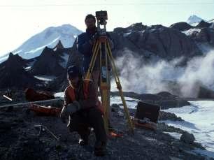
Mount Spurr geothermal workshop August 27 28, 2007
 Mount Spurr geothermal workshop August 27 28, 2007 Geologic Overview & Review of Geothermal Exploration Christopher Nye geologist / volcanologist DNR/GGS & AVO Alaska Division of Geological and Geophysical
19. Esan Continuously Monitored by JMA
 19. Esan Continuously Monitored by JMA Latitude: 41 48'17" N, Longitude: 141 09'58" E, Elevation: 618 m (Esan) (Triangulation Point) Overview of Esan, taken from east side on March 13, 2009 by the Japan
GEOLOGY MEDIA SUITE Chapter 12
 UNDERSTANDING EARTH, SIXTH EDITION GROTZINGER JORDAN GEOLOGY MEDIA SUITE Chapter 12 Volcanoes 2010 W.H. Freeman and Company Plate tectonics explains the global pattern of volcanism. Key Figure 12.20 (page
Location Option Details. 1. Florida
 1. Florida Florida has the smallest number of earthquaes in the United States. Florida is the U.S. location where hurricanes are most frequent. Of the six deadliest hurricanes to hit the continental U.S.,
Pyroclastic Flows. Lesson 6
 Pyroclastic Flows Lesson 6 P yroclastic flows are one of the most dangerous natural events that occur on our planet. They can at hurricane speeds down the slopes of a mountain, destroying everything in
Brita Horlings
 Knut Christianson Brita Horlings brita2@uw.edu https://courses.washington.edu/ess431/ Natural Occurrences of Ice: Distribution and environmental factors of seasonal snow, sea ice, glaciers and permafrost
Elwha River response to dam removals through four years and a big flood:
 Elwha River response to dam removals through four years and a big flood: Lessons learned, channel response, and sediment effects from the world s largest engineered dam removal Andy Ritchie NPS Elwha Restoration
A bowl shaped depression formed by the collapse of a volcano is called a. Magma that has left the vent of a volcano is known as. Lava.
 Magma that has left the vent of a volcano is known as Lava A bowl shaped depression formed by the collapse of a volcano is called a Caldera This can form in a caldera when magma starts to come back up
LECTURE #11: Volcanoes: Monitoring & Mitigation
 GEOL 0820 Ramsey Natural Disasters Spring, 2018 LECTURE #11: Volcanoes: Monitoring & Mitigation Date: 15 February 2018 I. What is volcanic monitoring? the continuous collection of one or more data sources
L wave Lahar Lava Magma
 Very large collapsed volcanic crater, often containing a lake eg. Lake Taupo The process which provides the force to move the tectonic plates Innermost part of the Earth, made of a liquid outer core and
Visualizing Earth Science. Chapter Overview. Volcanoes and Eruption Types. By Z. Merali and B. F. Skinner. Chapter 9 Volcanism and Other
 Visualizing Earth Science By Z. Merali and B. F. Skinner Chapter 9 Volcanism and Other Igneous Processes Volcanoes types and effects of eruption Chapter Overview Melting and cooling of rocks Geological
Keywords: Mount St. Helens, interpolation, GIS, change detection, scale, spatial techniques
 A sensitivity analysis of scale and sampling techniques on volumetric change on Mount St. Helens Douglas Thalacker Portland State University thal2@pdx.edu Abstract Mount St. Helens (MSH) underwent significant
Earthquakes and Volcanoes
 Earthquakes and Volcanoes Volcanoes What do you think? Read the three statements below and decide whether you agree or disagree with them. Place an A in the Before column if you agree with the statement
Geol 101: Physical Geology Fall 2006 EXAM 2
 Geol 101: Physical Geology Fall 2006 EXAM 2 Write your name out in full on the scantron form and fill in the corresponding ovals to spell out your name. Also fill in your student ID number in the space
Volcanoes. Table of Contents Volcanoes and Plate Tectonics Volcanic Eruptions Volcanic Landforms
 Volcanoes Table of Contents Volcanoes and Plate Tectonics Volcanic Eruptions Volcanic Landforms What is a volcano? cone Conduit Or Pipe vent Side vent Central vent Crater A volcano is a vent or 'chimney'
Volcanoes: Help or Hindrance?
 Volcanoes: Help or Hindrance? Volcanic eruptions can range from violent to mild. All kinds of eruptions have effects that can be both harmful and beneficial to people and the environment. Volcanoes Can
Tectonics of Magma. From partial melting of mantle Occurs at oceanic ridges and mantle plumes More dense: makes oceanic crust
 VOLCANOES Tectonics of Magma Basaltic magma From partial melting of mantle Occurs at oceanic ridges and mantle plumes More dense: makes oceanic crust Granitic magma From melting of crust, with water as
EAS 116 Earthquakes and Volcanoes
 EAS 116 Earthquakes and Volcanoes J. Haase Forecasting Volcanic Eruptions Assessment of Volcanic Hazard Is that volcano active? Mount Lassen: 12000 BP and 1915 Santorini, IT: 180,000 BP, 70,000 BP, 21000
Volcanoes. volcanic hazards. Image courtesy of USGS.
 Volcanoes volcanic hazards Volcanic hazards Pyroclastic flows and surges Pyroclastic flows and surges PYROCLAST: all solid fragments ejected from volcanoes PYROCLASTIC FLOW: A flow of hot gas and volcanic
! Profile of Mauna Loa in Hawaii. Mauna Loa is one of five huge shield volcanoes that make up the island of Hawaii.
 - Shield Volcanoes - Low, rounded profiles; slope angles 2-10 ; composed of numerous flows of mafic composition and little explosive activity - Largest of all volcanoes! Shield volcanoes consist of numerous
Earthquakes, volcanic eruptions, tsunamis (why do we live here?) Tectonic plates. Tectonic plates: Juan de Fuca. Volcanism the past 37 million years
 Tectonic plates. Tectonic plates: Juan de Fuca. Volcanism the past 37 million years") Earthquakes, volcanic eruptions, tsunamis (why do we live here?) Tectonic plates Tectonic plates: Juan de Fuca Volcanism the past 37 million years Tectonic plates: Juan de Fuca Volcanism the past 37 million
Earthquakes, volcanic eruptions, tsunamis (why do we live here?) Tectonic plates Tectonic plates: Juan de Fuca Volcanism the past 37 million years Tectonic plates: Juan de Fuca Volcanism the past 37 million
Objectives: Describe how volcanoes can affect people. Describe conditions that cause volcanoes. Describe the relationship between volcanoes and Earth
 Objectives: Describe how volcanoes can affect people. Describe conditions that cause volcanoes. Describe the relationship between volcanoes and Earth s moving plates. Inside of Old Smokey, All covered
Introduction to volcanoes. Volcano: an opening in the earth s surface through which lava, hot gases, and rock fragments erupt
 Introduction to volcanoes Volcano: an opening in the earth s surface through which lava, hot gases, and rock fragments erupt Origin of Volcanoes 1. Magma 50-100 miles below the earth s surface slowly begins
Volcanism (Chapter 5)
") GEOLOGY 306 Laboratory Instructor: TERRY J. BOROUGHS NAME: Volcanism (Chapter 5) For this assignment, you will require: a calculator, colored pencils, string, protractor, stereoscopes (provided). Objectives
GEOLOGY 306 Laboratory Instructor: TERRY J. BOROUGHS NAME: Volcanism (Chapter 5) For this assignment, you will require: a calculator, colored pencils, string, protractor, stereoscopes (provided). Objectives
Guidance for GEOGRAPHY End of Year Examination 2016
 Guidance for GEOGRAPHY End of Year Examination 2016 The End of Year Examination takes place in Week 4 of the Summer Term. The Geography Examination will last 50 minutes. The Examination will include questions
Columbia River Gorge Near Perfection... And Only 40+ Million Years in the Making
 Columbia Gorge Geology and the Ice Age Floods Columbia River Gorge Near Perfection... And Only 40+ Million Years in the Making Lloyd DeKay, Ice Age Floods Institute - Columbia Gorge Chapter GorgeFloods.org
Effects of Eruptions. Most active in the world Kilauea, Hawaii.
 Inside of Old Smokey, All covered with snow, Lurk tons of hot magma, Getting ready to blow, Objectives: From deep in the chamber, Describe how volcanoes can affect people. Up a vent to the top, Describe
Question #1: What are some ways that you think the climate may have changed in the area where you live over the past million years?
 Reading 5.2 Environmental Change Think about the area where you live. You may see changes in the landscape in that area over a year. Some of those changes are weather related. Others are due to how the
Study Guide: Unit 1. 1) Take careful notes in class during the lectures as well as the information given in the slides presented during class
 Take careful notes in class during the lectures as well as the information given in the slides presented during class") Geology 101 Study Guide: Unit 1 The purpose of this study guide is to help you prepare for the first unit exam by focusing your studying and providing example essay questions. You will not be asked to
Geology 101 Study Guide: Unit 1 The purpose of this study guide is to help you prepare for the first unit exam by focusing your studying and providing example essay questions. You will not be asked to
Monitoring Cascade Volcanoes
 Cascades Volcano Observatory Cascade Volcanoes http://volcanoes.usgs.gov/observatories/cvo/cvo_monitoring.html Cascade Volcanoes Volcano eruption forecasting relies on several disciplines of volcanology.
Pacific Northwest Rock Lab, Part II. Igneous Rocks. Name Per.
 Name Per. Pacific Northwest Rock Lab, Part II After you ve classified all your rocks, place their numbers next to the names and read the information about the rock. Check the classifications here (igneous,
MULTIPLE CHOICE. Choose the one alternative that best completes the statement or answers the question.
 Exam Quiz 2 ES 117 Natural Disasters Aronson Name MULTIPLE CHOICE. Choose the one alternative that best completes the statement or answers the question. 1) The most famous of all volcanoes probably is
VOLCANO HAZARDS IN THE MOUNT HOOD REGION, OREGON
 U.S. Department of the Interior U.S. Geological Survey VOLCANO HAZARDS IN THE MOUNT HOOD REGION, OREGON By W.E. Scott 1, T.C. Pierson 1, S.P. Schilling 1, J.E. Costa 1, C.A. Gardner 1, J.W. Vallance 2,
Surname 1. Name: Instructor s Name: Course Number: Date: Geological Significance
 Surname 1 Name: Instructor s Name: Course Number: Date: Geological Significance Eruption of Mt. St. Helens in 1980 Eruption of Mt.St. Helens in the 1980s availed a significant learning experience in geology.
Posteruption glacier development within the crater of Mount St. Helens, Washington, USA
 Quaternary Research 61 (2004) 325 329 Short Paper Posteruption glacier development within the crater of Mount St. Helens, Washington, USA Steve P. Schilling, a, * Paul E. Carrara, b Ren A. Thompson, b
Part A GEOLOGY 12 CHAPTER 4 WORKSHEET VOLCANOES. Name
 GEOLOGY 12 CHAPTER 4 WORKSHEET VOLCANOES Name Part A 1. The rough, jumbled blocky or jagged surface of a lava flow is called a. pahoehoe b. lahar c. aa d. phreatic 2. The Cascade volcanoes like Mt. St.
Geology 101. Reading Guide for Chapters 1, 4, and 5
 Geology 101 Name Reading Guide for Chapters 1, 4, and 5 The purpose of the Reading Guides is to help you sort out the most important ideas in the text. I recommend answering the questions as you read the
Geologic Evolution of the Skagit River Channel Migration Zone. J. Riedel National Park Service
 Geologic Evolution of the Skagit River Channel Migration Zone J. Riedel National Park Service LSWT BT OT CMZ defined by: 1) Areas within FEMA floodplain of Skagit River (100 and 500 year); 2) Areas within
Geol 101: Physical Geology Fall 2002 EXAM 1
 Geol 101: Physical Geology Fall 2002 EXAM 1 Write your name out in full on the scantron form and fill in the corresponding ovals to spell out your name. Also fill in your student ID number in the space
Living on the Edge: Unit 5: Convergent Plate Boundaries
 Living on the Edge: Unit 5: Convergent Plate Boundaries Because of its eleva.on (4,392 m), relief, hydrothermal altera.on, ice cap, glacier- fed radial valleys, and proximity to suburbs of the SeaBle-
Directed Reading page
 Skills Worksheet Directed Reading page 185-190 Section: Determining Relative Age 1. How old is Earth estimated to be? 2. Who originated the idea that Earth is billions of years old? 3. On what did the
Chapter Twelve: Earthquakes
 The Changing Earth Chapter Twelve: Earthquakes 12.1 Earthquakes 12.2 Volcanoes Investigation 12B Volcanoes How are volcanoes and plate boundaries related? 12.2 Looking inside a volcano A volcano is where
Volcano - A Volcano is an opening in the Earth s surface through which molten material or volcanic gases are erupted.
 What is a Volcano? Volcano - A Volcano is an opening in the Earth s surface through which molten material or volcanic gases are erupted. A volcano can either be a classic volcanic cone.. Mt. St. Helens,
ESC1000 Earth Science Summer 2016
 ESC1000 Earth Science Summer 2016 As a scientifically literate citizen, what 3 questions would you ask about this volcano if you moved to the city in the foreground (Tacoma, Washington)? Volcanoes (Chapter
Assessment of the Hood River Delta Hood River, Oregon
 Assessment of the Hood River Delta Hood River, Oregon Pacific Northwest Waterways Association Annual Meeting October 13, 2010 Michael McElwee, Executive Director Port of Hood River Overview U.S. Army Corps
Safety Procedures for Volcanic Activity in the United States and Japan
 Parkland College A with Honors Projects Honors Program 2015 Safety Procedures for Volcanic Activity in the United States and Japan Ashley Eisenmenger Parkland College Recommended Citation Eisenmenger,
b. Why is the area affected by each earthquake circular or nearly circular? Where is the epicenter of each quake located?
 Name: Skill Sheet 29-A Interpreting Geologic Hazard Maps Plate tectonics and the weather are often the cause of geologic hazards such as earthquakes, volcanic eruptions, and flooding. Geologic hazard events
FIREPLACE GEOLOGY. Dining Hall
 FIREPLACE GEOLOGY Dining Hall The Dining Hall fireplace represents a slice through a Cascade Mountain volcano. Volcanoes are formed from molten magma rising up from within the Earth s crust. Magma that
Latitude: 34 31'13" N, Longitude: '45" E, Elevation: 508 m (Miyatsukayama) (Triangulation Point - Toshima)
 (Triangulation Point - Toshima)") 59. Toshima Latitude: 34 31'13" N, Longitude: 139 16'45" E, Elevation: 508 m (Miyatsukayama) (Triangulation Point - Toshima) Overview of Toshima taken from northwest side on October 30, 2002 by the Japan
59. Toshima Latitude: 34 31'13" N, Longitude: 139 16'45" E, Elevation: 508 m (Miyatsukayama) (Triangulation Point - Toshima) Overview of Toshima taken from northwest side on October 30, 2002 by the Japan
A R T I C L E S RAPID EROSION AT MOUNT ST. HELENS
 A R T I C L E S RAPID EROSION AT MOUNT ST. HELENS Steven A. Austin Research Associate in Geology Institute for Creation Research El Cajon, California WHAT THIS ARTICLE IS ABOUT How long does it take for
St. Helens: Out of the Ash Learning Resource Guide
 St. Helens: Out of the Ash Learning Resource Guide Overview: In May of 1980 Mount St. Helens grabbed the world s attention by putting on a volcanic display never before witnessed in modern times. Today,
1/31/2013 BASALTIC BASALTIC ANDESITIC RHYOLITIC
 Can you predict the location of volcanoes? What is causing this eruption? What factors influence its character? A volcano is any landform from which lava, gas, or ashes, escape from underground or have