Four Soil Orders on a Vermont mountaintop One-third of the world s soil orders in a 2500 square meter research plot
|
|
|
- Cory Johns
- 6 years ago
- Views:
Transcription
1 Four Soil Orders on a Vermont mountaintop One-third of the world s soil orders in a 2500 square meter research plot Thomas R. Villars, Scott W. Bailey, Donald S. Ross
2


3 38% of world s soils are in these 4 soil Orders
4 The overall goal of the Vermont Long-term Soil Monitoring Project, under the auspices of the Vermont Monitoring Cooperative is to monitor forest soils for changes due to human-caused impacts, such as climate change and air pollution. Major partners in the project: Vermont Agency of Natural Resources University of Vermont USDA Natural Resources Conservation Service (NRCS) USDA Forest Service-Green Mountain National Forest US Geological Survey.
5 In 2002, ten randomly selected subplots at each Vermont Long-term Soil Monitoring Project plot were sampled for the first time. The Forehead plot on Mt Mansfield is the highest elevation plot - approximately 1120 m (3696 ft) on the shoulder of Mount Mansfield, highest summit in Vermont, 1361 m (4493 ft) Soil temperature regime is cryic Mapped soils at plot are: Londonderry series - loamy, mixed, active, acid Lithic Cryorthents (Entisol) Stratton series - loamy-skeletal, isotic Lithic Humicryods (Spodosol) Bockheim (2010) describes these high-elevation northeastern US soils as disjunct soils, which have formed on widely separated mountain peaks over a broad geographic region.
, red spruce (Picea rubens) and American mountain ash (Sorbus")
6 Vegetation is montane spruce-fir forest, primarily balsam fir (Abies balsamea), red spruce (Picea rubens) and American mountain ash (Sorbus americana)
7 Results Slopes measured at each soil pit ranged from 16 to 38 percent All pedons had surface layer O horizons, ranging from 4 to 17 cm thick All pedons had a lithic contact to schist bedrock Depth of solum ranged from 12 to 69 cm from the top of the soil surface and from 4 to 60 cm from the top of the mineral soil surface Particle size textural class for all mineral layers was Loamy or Coarse-loamy Two pedons had B horizons that met the requirement for spodic horizons (Bhs) One other B horizon was observed - did not meet the requirements for spodic materials (labelled as Bw horizon in description)
8
9 Histosols Small subset in the Northeast found on cold mountain summits and upper sideslopes, such as the Mount Mansfield Forehead plot These Histosols have organic soil materials that constitute two thirds or more of the total thickness of the soil to a densic, lithic, or paralithic contact and have no mineral horizons or have mineral horizons with a total thickness of 10 cm or less


10 Spodosols Common in the Green Mountains of Vermont, but only two pedons have spodic horizons Bhs horizons have matrix color of 5YR 3/3. Subplot 33 pedon

11 Inceptisols Three pedons have folistic epipedons with combined O horizons 15 cm or more thick. Beginning with the 12 th Edition to Keys to Soil Taxonomy (2014), they key out as Inceptisols. One pedon also has an E horizon 32 cm thick. This is an altered horizon greater than 15 cm thick - meets basic requirements of a cambic horizon, along with meeting the criteria for an albic horizon. With a cryic soil temperature regime, it keys out as an Inceptisol. These pedons classify as Lithic Dystrocryepts. Do not fit range in characteristics for any established soil series.

12 Entisols Four pedons key out as Entisols. Not Histosols because their O horizons are too thin to equal 2/3 rd of the total thickness to the lithic contact. Not Inceptisols because the O horizons are too thin to be folistic epipedons and their albic horizons are too thin to meet the requirements for a cambic horizon. Not Spodosols because they lack a spodic horizon. All four fit the range in characteristics of the mapped Londonderry series.
13 After subsequent 5-year interval sampling of 10 more subplots in 2007 and 2012: The classification of the 30 pedons sampled to date key out as: 13% Histosols 27% Spodosols 40% Inceptisols 20% Entisols In one corner of the plot, all four soil orders were described within a 15m x 15m area
14 2002, 2007, 2012 results E Entisols H Histosols I Inceptisols S - Spodosols


15 Soil Profile Charts for 2002, 2007, and 2012 VMC Forehead Plot Sampling
16 Closing comments The high-elevation spruce-fir Forehead plot on Mount Mansfield includes soils of four taxonomic Orders: Entisols, Histosols, Inceptisols, and Spodosols. Site was selected for its supposed uniformity of soils, landscape position and slope. Excluding the pedons with spodic horizons, soils with just O, E, and R horizons classify as three different soil orders. There are instances where very similar soils can end up looking considerably different when viewed through the lens of Soil Taxonomy.
17 The task of observing and describing a soil profile is an important factor in field studies. When there is more than one soil scientist or teams of soil scientists working on a project either simultaneously or in sequence, consistency and oversight is critical. Best way to insure consistency in soil descriptions - limit the number of people making the descriptions develop a set of protocols to aid in identifying soil horizons. have a single soil scientist review all descriptions after sampling to check for discrepancies. The difference of one centimeter in the recorded depth to the boundary between two horizons can create a significant difference in the classification of a pedon.
18
19
HYDRIC SOILS. Background
 Background HYDRIC SOILS Soils consist of natural bodies that occur on a landform within a landscape and have properties that result from the integrated effects of climate and living organisms, acting on
Lecture 7: Introduction to Soil Formation and Classification
 Lecture 7: Introduction to Soil Formation and Classification Soil Texture and Color Analysis Lab Results Soil A: Topsoil from Prof. Catalano s backyard Soil B: Soil above beach at Castlewood State Park
Introduction to Soil Science and Wetlands Kids at Wilderness Camp
 Introduction to Soil Science and Wetlands Kids at Wilderness Camp Presented by: Mr. Brian Oram, PG, PASEO B.F. Environmental Consultants http://www.bfenvironmental.com and Keystone Clean Water Team http://www.pacleanwater.org
Temperature and Precipitation. Next stage will depend on climate and parent materials
 Next stage will depend on climate and parent materials Rainfall and temperature will determine nature of vegetation Resistance of parent material to weathering will determine rate and type of clay formation,
Soil Surveys. What are the most important properties to consider in a taxonomic system used for making a soil survey?
 Soil Surveys What are the most important properties to consider in a taxonomic system used for making a soil survey? What is a Soil Survey? Inventory of soil resources Delineation of spatial distribution
Ecosystem classification in the Central Rocky Mountains, Utah
 Ecosystem classification in the Central Rocky Mountains, Utah Introduction Societal demand for sustainable natural resources: Manage ecosystems rather than individual resources; ecosystem-specific approach
Soil Taxonomy Classification Jackson County, Florida (Chipola River) Web Soil Survey National Cooperative Soil Survey
 Web Soil Survey National Cooperative Soil Survey") 85 10' 20'' W Soil Taxonomy Classification Jackson County, Florida () 85 9' 8'' W 30 37' 42'' N 30 37' 42'' N 30 37' 2'' N 30 37' 2'' N 85 10' 20'' W N Map Scale: 1:8,740 if printed on A landscape (11"
85 10' 20'' W Soil Taxonomy Classification Jackson County, Florida () 85 9' 8'' W 30 37' 42'' N 30 37' 42'' N 30 37' 2'' N 30 37' 2'' N 85 10' 20'' W N Map Scale: 1:8,740 if printed on A landscape (11"
Custom Soil Resource Report Soil Map
 121 3' 56'' W Custom Soil Resource Report Soil Map 121 2' 49'' W 45 16' 39'' N 5013800 5014000 5014200 5014400 5014600 5014800 5015000 5015200 5015400 5015600 651800 652000 652200 652400 652600 652800
Soil Taxonomy Classification Osage County, Kansas. Web Soil Survey National Cooperative Soil Survey
 95 45' 5'' W Soil Taxonomy Classification Osage County, Kansas 95 44' 3'' W 260300 260400 260500 260600 260700 260800 260900 261000 261100 261200 261300 261400 261500 261600 261700 38 33' 4'' N 38 32'
Soil Taxonomy Classification Washington County, Florida (Pine Log 631A)
") 85 54' 36'' W Soil Taxonomy Classification Washington County, Florida () 85 53' 22'' W 30 25' 42'' N 30 25' 42'' N 30 24' 17'' N 30 24' 17'' N 85 54' 36'' W N Map Scale: 1:12,700 if printed on A portrait
85 54' 36'' W Soil Taxonomy Classification Washington County, Florida () 85 53' 22'' W 30 25' 42'' N 30 25' 42'' N 30 24' 17'' N 30 24' 17'' N 85 54' 36'' W N Map Scale: 1:12,700 if printed on A portrait
Stephanie J. Connolly Forest Soil Scientist
 Stephanie J. Connolly Forest Soil Scientist Approximately 1 million acres High elevation Steep slopes Rain shadow effect Hydrologically shallow soils Sedimentary geology Acidic environments Biodiversity
PHYSICAL GEOGRAPHY. By Brett Lucas
 PHYSICAL GEOGRAPHY By Brett Lucas SOILS Soils Soil and Regolith Soil-Forming Factors Soil Components Soil Properties Soil Chemistry Soil Profiles Pedogenic Regimes Global Distribution of Soils Distribution
Web Soil Survey National Cooperative Soil Survey
 95 27' 24'' W Soil Taxonomy Classification Franklin County, Kansas 95 26' 23'' W 285800 285900 286000 286100 286200 286300 286400 286500 286600 286700 286800 286900 287000 287100 287200 38 29' 34'' N 38
Web Soil Survey National Cooperative Soil Survey
 95 30' 19'' W Soil Taxonomy Classification Franklin County, Kansas 95 29' 28'' W 38 33' 8'' N 281700 281800 281900 282000 282100 282200 282300 282400 282500 282600 282700 282800 282900 38 33' 8'' N 4269300
12- TOL MLRA Soil Survey Area Approximately 15,000,000 Acres
 !@ 12- TOL MLRA Soil Survey Area Approximately 15,000,000 Acres Office Location: Tolland, Connecticut Staff: Donald Parizek Acting Soil Survey Office Party Leader Jacob Isleib Soil Scientist Marissa Theve
Web Soil Survey National Cooperative Soil Survey
 95 40' 40'' W 95 40' 0'' W 38 44' 27'' N 4290200 4290300 4290400 4290500 4290600 4290700 4290800 4290900 4291000 4291100 4291200 4291300 4291400 267300 267400 267500 267600 267700 267800 267900 268000
Vermont Soil Climate Analysis Network (SCAN) sites at Lye Brook and Mount Mansfield
 sites at Lye Brook and Mount Mansfield") Vermont Soil Climate Analysis Network (SCAN) sites at Lye Brook and Mount Mansfield 13 Years of Soil Temperature and Soil Moisture Data Collection September 2000 September 2013 Soil Climate Analysis Network
Vermont Soil Climate Analysis Network (SCAN) sites at Lye Brook and Mount Mansfield 13 Years of Soil Temperature and Soil Moisture Data Collection September 2000 September 2013 Soil Climate Analysis Network
Chemical Weathering and Soils
 Chemical Weathering and Soils Fresh rocks and minerals that once occupied the outermost position reached their present condition of decay through a complex of interacting physical, chemical, and biological
Soil Taxonomy Classification Gadsden County, Florida (Imperial Nursery)
") 84 35' 33'' W 84 38' 3'' W Soil Taxonomy Classification Gadsden County, Florida () 30 32' 17'' N 30 32' 17'' N Map Scale: 1:25,700 if printed on A portrait (8.5" x 11") sheet. N 0 350 700 0 1000 2000 4000
84 35' 33'' W 84 38' 3'' W Soil Taxonomy Classification Gadsden County, Florida () 30 32' 17'' N 30 32' 17'' N Map Scale: 1:25,700 if printed on A portrait (8.5" x 11") sheet. N 0 350 700 0 1000 2000 4000
On-Site Soils Investigation. Buttermilk Way Storm water Treatment Project Buzzards Bay. MA. February 28 th, 2012
 1 On-Site Soils Investigation Buttermilk Way Storm water Treatment Project Buzzards Bay. MA February 28 th, 2012 Glenn Stanisewski, Resource Soil Scientist, USDA-NRCS, West Wareham, MA Introduction: The
2017 NACTA Contest FAQs for 4-Year Universities
 2017 NACTA Contest FAQs for 4-Year Universities 2-6-17 1. Do you recognize Cd horizons in the contest area? a. We have Permian mudstones and shales in the contest area that have traditionally been described
Custom Soil Resource Report for San Juan Area, Puerto Rico
 United States Department of Agriculture Natural Resources Conservation Service A product of the National Cooperative Soil Survey, a joint effort of the United States Department of Agriculture and other
Soil Types. Detailed
 Soil Science and Soil Physics Lecture 12 Soil Types Detailed Taxonomy according to FAO/UNESCO Basic soil horizons O A E B C R Plant litter at various levels of decomposition and humus - Organic matter)
Custom Soil Resource Report for Forrest County, Mississippi
 United States Department of Agriculture Natural Resources Conservation Service A product of the National Cooperative Soil Survey, a joint effort of the United States Department of Agriculture and other
CRUM RANCH AREA MAP YOLO COUNTY, California, AC +/-
 CRUM RANCH AREA MAP YOLO COUNTY, California, 235.59 AC +/- Map data 2016 Google Imagery 2016, CAPCOG, DigitalGlobe, Texas Orthoimagery Program, U.S. Geological Survey, USDA Farm Service Agency Boundary
USING A KNOWLEDGE-BASED SYSTEM TO TEST THE TRANSFERABILITY OF A SOIL-LANDSCAPE MODEL IN NORTHEASTERN VERMONT
 USING A KNOWLEDGE-BASED SYSTEM TO TEST THE TRANSFERABILITY OF A SOIL-LANDSCAPE MODEL IN NORTHEASTERN VERMONT By JESSICA MCKAY A THESIS PRESENTED TO THE GRADUATE SCHOOL OF THE UNIVERSITY OF FLORIDA IN PARTIAL
GEOL Lab #11 Information (Guidelines for Student Soil Presentations on April 8)
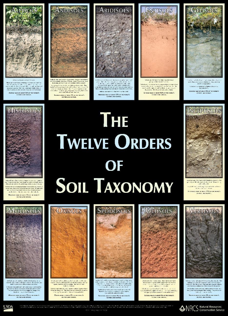
") GEOL 333 - Lab #11 Information (Guidelines for Student Soil Presentations on April 8) Assignment During Lab on April 8, you will give an oral presentation about one of the 12 soil orders (categories).
GEOL 333 - Lab #11 Information (Guidelines for Student Soil Presentations on April 8) Assignment During Lab on April 8, you will give an oral presentation about one of the 12 soil orders (categories).
Custom Soil Resource Report for Berkshire County, Massachusetts
 B. United States Department of Agriculture Natural Resources Conservation Service A product of the National Cooperative Soil Survey, a joint effort of the United States Department of Agriculture and other
Physical Geology, 15/e
 Lecture Outlines Physical Geology, 15/e Plummer, Carlson & Hammersley Weathering and Soil Physical Geology 15/e, Chapter 5 Weathering, Erosion and Transportation Rocks exposed at Earth s surface are constantly
A Genetic Approach to Mapping Ecosystems
 PowerPoint presentation given at the annual meeting of the Association of American Geographers, San Francisco, CA, April 17-21, 2007 Slide 1 A Genetic Approach to Mapping Ecosystems Robert G. Bailey USDA
Monday, Oct Field trip A1 & A2 signups: make sure you are where you think you should be
 Monday, Oct. 4 1. Field trip A1 & A2 signups: make sure you are where you think you should be 2. 5 credit people, field trip introduction in lab today 1. If you are unable to attend THIS SATURDAY, let
STUDENT SOIL PRESENTATIONS
 STUDENT SOIL PRESENTATIONS Soil Order (and informal name) Student Name(s) Alfisol = deciduous forest soil Andisol = formed on volcanic ash Aridisol = desert soil Entisol = alluvium soil Gelisol = tundra
Podzolization is the pedogenic process leading to the formation of podzols,
 Published March 13, 2015 Hydropedology Symposium: 10 Years Later and 10 Years into the Future Chemical and Morphological Distinctions between Vertical and Lateral Podzolization at Hubbard Brook Rebecca
Standards and Procedures for Site Specific Soil Mapping in Rhode Island. Pg 1
 Standards and Procedures for Site Specific Soil Mapping in Rhode Island Pg 1 The Task Take This and Create This The Task Take This and Create This and a Report Pg 2 How is this different than the RI Soil
Soil Map Boulder County Area, Colorado (Planet Blue Grass) Web Soil Survey National Cooperative Soil Survey
 Web Soil Survey National Cooperative Soil Survey") 475910 476000 476090 476180 476270 476360 105 16' 21'' W 476450 476540 476630 476720 476810 4453350 4453440 4453260 4453350 4453170 4453260 4453080 4453170 4453080 475820 475910 4452990 476000 476090 476180
475910 476000 476090 476180 476270 476360 105 16' 21'' W 476450 476540 476630 476720 476810 4453350 4453440 4453260 4453350 4453170 4453260 4453080 4453170 4453080 475820 475910 4452990 476000 476090 476180
NCSS/NRCS Updates & New Horizon Designation for ^Anthropogenic Soils. Jim Turenne, CPSS Assistant State Soil Scientist RI USDA NRCS
 NCSS/NRCS Updates & New Horizon Designation for ^Anthropogenic Soils Jim Turenne, CPSS Assistant State Soil Scientist RI USDA NRCS http://nesoil.com NCSS / NRCS Updates Major reorganization of the NCSS
Hydric Rating by Map Unit Harrison County, Mississippi. Web Soil Survey National Cooperative Soil Survey
 89 9' 7'' W 89 8' 38'' W 30 34' 13'' N 30 33' 57'' N 3383480 3383560 3383640 3383720 3383800 3383880 3383960 293640 293720 293800 293880 293960 294040 294120 294200 294280 294360 3383480 3383560 3383640
RANCHO de DOS PALMAS DAVIS, California, AC +/-
 RANCHO de DOS PALMAS DAVIS, California, 507.28 AC +/- Boundary Transmission Line Pond / Tank Well SCOTT STONE P: (530) 662-4094 sastone57@gmail.com 37874 County Road 28, Woodland, Ca. 95695 The information
Soil Taxonomy. A Basic System of Soil Classification for Making and Interpreting Soil Surveys. Second Edition, 1999 By Soil Survey Staff
 Soil Taxonomy A Basic System of Soil Classification for Making and Interpreting Soil Surveys Second Edition, 1999 By Soil Survey Staff United States Department of Agriculture Agriculture Handbook Natural
The Future of Soil Mapping using LiDAR Technology
 The Future of Soil Mapping using LiDAR Technology Jessica Philippe Soil Scientist/GIS Specialist March 24, 2016 Natural Resources Conservation Service Helping People Help the Land Area 12-STJ covers parts
Procedure for Determining Near-Surface Pollution Sensitivity
 Procedure for Determining Near-Surface Pollution Sensitivity Minnesota Department of Natural Resources Division of Ecological and Water Resources County Geologic Atlas Program March 2014 Version 2.1 I.
GIS Mapping for Hubbard Brook Experimental Forest A Service Learning Project for Plymouth Regional High School Environmental Science
 GIS Mapping for Hubbard Brook Experimental Forest A Service Learning Project for Plymouth Regional High School Environmental Science Hubbard Brook Experimental Forest [External Link], established in 1955
Boreal Forests. Boreal, Canadian Rockies, Alberta. Taiga, Siberia
 Coniferous forests are mainly found in broad circumpolar belt across the northern hemisphere and on mountain ranges where low temperatures limit the growing season to a few months each year - thus too
Essentials of Geology, 11e
 Essentials of Geology, 11e and s Chapter 5 Instructor Jennifer Barson Spokane Falls Community College Geology 101 Stanley Hatfield Southwestern Illinois College Jennifer Cole Northeastern University Earth
LAA. Wassents that have sulfidic materials within 50 cm of the mineral soil surface. Sulfiwassents
 Wassents Wassents are subaqueous Entisols. Defined as Entisols that have a positive water potential at the soil surface for at least 90% of each day. These soils are the first suborder to classify out
Lab Topographic Maps. Name: Partner: Purpose. Background Information
 Lab Topographic Maps Name: Partner: Purpose The purpose of this lab is to familiarize you with graphic representations of the Earth s surface primarily maps. Simple line maps show the spatial relationship
Custom Soil Resource Report for Coryell County, Texas
 United States Department of Agriculture Natural Resources Conservation Service A product of the National Cooperative Soil Survey, a joint effort of the United States Department of Agriculture and other
2011 Pearson Education, Inc.
 Weathering and Soil Earth - Chapter 6 Earth s External Processes Weathering the physical breakdown and chemical decomposition of rock Mass wasting the transfer of rock and soil downslope under the influence
2011 Pearson Education, Inc.
 Weathering and Soil Earth - Chapter 6 Earth s External Processes Weathering the physical breakdown and chemical decomposition of rock Mass wasting the transfer of rock and soil downslope under the influence
Custom Soil Resource Report for Polk County, Oregon
 United States Department of Agriculture Natural Resources Conservation Service A product of the National Cooperative Soil Survey, a joint effort of the United States Department of Agriculture and other
Lecture 5b, 6, & 7a: Soils I, II, & III. Soil:
 Lecture 5b, 6, & 7a: Soils I, II, & III Spring 2007 WVU GEOL 321 (J.S. Kite) Soil: Assemblage of natural bodies on the Earth s surface (natural or artificial) capable of supporting plant life outdoors
Soil Morphology and Stratigraphy on an Erosional Footslope: Dickinson Experiment Station in Western North Dakota
 Soil Morphology and Stratigraphy on an Erosional Footslope: Dickinson Experiment Station in Western North Dakota By D. Claypool, D. G. Hopkins, and J. L. Richardson ABSTRACT A first order soil survey of
Organic Carbon Pools and Genesis of Alpine Soils with Permafrost: A Review
 Organic Carbon Pools and Genesis of Alpine Soils with Permafrost: A Review Author(s): James G. Bockheim and Jeffrey S. Munroe Source: Arctic, Antarctic, and Alpine Research, 46(4):987-1006. Published By:
SOIL: DEFINITION, FORMATION! & LAYERS"
 SOIL: DEFINITION, FORMATION & LAYERS" What Is Soil? soil - upper-most (relatively thin) layer of Earth s crust, which supports terrestrial plants, animals, & microorganisms basic natural resource that
Directed Reading. Section: Types of Maps
 Skills Worksheet Directed Reading Section: Types of Maps 1. What are some of the characteristics of an area shown on maps used by Earth scientists? a. types of animals, types of plants, types of minerals
Despite their relatively low elevations, the highest summits in
 Alpine Soils on Mount Mansfield, Vermont, USA: Pedology, History, and Intraregional Comparison Jeffrey S. Munroe* Geology Dep. Middlebury College Middlebury, VT 05753 The highest summits in the northeastern
Ecogeographic Analysis A Guide to the Ecological Division of Land for Planning and Management
 Slide 1 Ecogeographic Analysis A Guide to the Ecological Division of Land for Planning and Management Robert G. Bailey USDA Forest Service Ecoregions, Ecosystem Geography and Sustainability rgbailey@fs.fed.us
Pedodiversity and Island Soil Geography: Testing the Driving Forces for Pedological Assemblages in Archipelagos of Different Origins
 Pedodiversity and Island Soil Geography: Testing the Driving Forces for Pedological Assemblages in Archipelagos of Different Origins William R. Effland, Ph.D. Soil Survey Division, USDA/NRCS A. Rodriguez-Rodriguez,
Custom Soil Resource Report for Gem County Area, Idaho
 United States Department of Agriculture Natural Resources Conservation Service A product of the National Cooperative Soil Survey, a joint effort of the United States Department of Agriculture and other
Changing Ecoregional Map Boundaries
 February 12, 2004 By Robert G. Bailey, USDA Forest Service, Inventory & Monitoring Institute Changing Ecoregional Map Boundaries The Forest Service has developed a mapping framework to help managers better
Custom Soil Resource Report for Victoria County, Texas
 United States Department of Agriculture Natural Resources Conservation Service A product of the National Cooperative Soil Survey, a joint effort of the United States Department of Agriculture and other
Accurate digital mapping of rare soils
 Accurate digital mapping of rare soils Colby Brungard 1,, Budiman Minasny 2 1 Department of Plants, Soils, and Climate, Utah State University, United States 2 Faculty of Agriculture & Environment, The
Custom Soil Resource Report for Coryell County, Texas
 United States Department of Agriculture Natural Resources Conservation Service A product of the National Cooperative Soil Survey, a joint effort of the United States Department of Agriculture and other
Business. Meteorologic monitoring. Field trip? Reader. Other?
 Business Meteorologic monitoring Field trip? Reader Other? Classification Streams Characterization Discharge measurements Why classify stream channels? Why Classify Stream Channels? Provides a common language
Mechanical Weathering
 Weathering is the disintegration and decomposition of material at or near the surface. Erosion is the incorporation and transportation of material by a mobile agent, usually water, wind, or ice. Geologists
Terrain Attributes Aid Soil Mapping on Low-Relief Indiana
 Terrain Attributes Aid Soil Mapping on Low-Relief Indiana Landscapes Zamir Libohova 12 1,2 Edwin Winzeler 1 Phillip R. Owens 1 1 Agronomy, Purdue University, West Lafayette, IN 2 USDA/NRCS, Indianapolis,
Curtis Monger USDA-NRCS Developments in Soil Taxonomy
 Curtis Monger USDA-NRCS Developments in Soil Taxonomy rice ANTHROPOCENE? Ca Curtis Monger USDA-NRCS Developments in Soil Taxonomy rice ANTHROPOCENE? Soil sustainability differs across the landscape. Ca
Vegetation and Soil Sampling for STM and ESD Development
 Vegetation and Soil Sampling for STM and ESD Development Brandon Bestelmeyer David Trujillo Dan Robinett USDA-ARS Jornada Experimental Range USDA-NRCS Tucson, AZ Sampling for ESDs Part 1: How can sampling
Soil is, by far, the major resource for food production worldwide
 Soil is, by far, the major resource for food production worldwide Soils Function As: 1 Medium for plant growth 2 Recycling system for nutrients and organic waste 3 Habitat for soil organisms 4 System for
Custom Soil Resource Report for Coryell County, Texas
 United States Department of Agriculture Natural Resources Conservation Service A product of the National Cooperative Soil Survey, a joint effort of the United States Department of Agriculture and other
PART ONE A Valuable Resource for CERM ICP-MS in Catskills Research Presented by Alison Keimowitz Associate Professor of Chemistry, Vassar College
 PART ONE A Valuable Resource for CERM ICP-MS in Catskills Research Presented by Alison Keimowitz Associate Professor of Chemistry, Vassar College PART TWO A Collaborative Research Example Chemistry of
Custom Soil Resource Report Soil Map
 77 35' 22'' W Custom Soil Resource Report Soil Map 77 35' 0'' W 282170 282220 282270 282320 282370 282420 282470 282520 282570 282620 40 59' 2'' N 40 58' 52'' N 4539900 4539950 4540000 4540050 4540100
O\.OLSSON \ ASSOC I ATES
 O\.OLSSON \ ASSOC I ATES NRCS Soils Report Larry D. Knox Juniper Hills Private Landing Strip ) OAProject No. 012-1776 760 Horizon Drive, Suite 1021 Grand Junction, CO 815061 TEL 970.263.7800 I FAX 970.263.7456
Using the Web Soil Survey Resilience and Resistance Score Sheet Soils Report
 Using the Resilience and Resistance Score Sheet Soils Report 1. Go to http://websoilsurvey.nrcs.usda.gov/app/ and click on the Start WSS button. 2. Create an Area of Interest (AOI) using any of the available
Lecture 6: Soil Profiles: Diagnostic Horizons
 Lecture 6: Soil Profiles: Diagnostic Horizons Complexity in Soil Profiles Soil Horizons Soils display distinct layering O Horizon: Partially decomposed organic matter (OM) A Horizon: Near surface, mineral
Custom Soil Resource Report for Hill County, Texas
 United States Department of Agriculture Natural Resources Conservation Service A product of the National Cooperative Soil Survey, a joint effort of the United States Department of Agriculture and other
Custom Soil Resource Report for Coryell County, Texas
 United States Department of Agriculture Natural Resources Conservation Service A product of the National Cooperative Soil Survey, a joint effort of the United States Department of Agriculture and other
Geology Rocks Minerals Earthquakes Natural Resources. Meteorology. Oceanography. Astronomy. Weather Storms Warm fronts Cold fronts
 Geology Rocks Minerals Earthquakes Natural Resources Meteorology Weather Storms Warm fronts Cold fronts Oceanography Mid ocean ridges Tsunamis Astronomy Space Stars Planets Moon Prologue 1 Prologue I.
Custom Soil Resource Report for Santa Fe Area, New Mexico, Santa Fe County and Part of Rio Arriba County; and Santa Fe County Area, New Mexico
 United States Department of Agriculture Natural Resources Conservation Service A product of the National Cooperative Soil Survey, a joint effort of the United States Department of Agriculture and other
Factors of available soil water in Texas. Map Comparison project
 Factors of available soil water in Texas Map Comparison project Brandon J. Okafor 12/6/2013 Introduction Geology of Texas From mountains to coastal plains, Texas poses a great number of various physiographic
Region IV Soils Contest Oct. 3-7, 2016 Texas Tech University Ruidoso, NM
 Region IV Soils Contest Oct. 3-7, 2016 Texas Tech University Ruidoso, NM David C. Weindorf Texas Tech University Box 42122 Lubbock, TX 79409 David.weindorf@ttu.edu 806.834.5287 office 225.223.2911 cell
Hydric Rating by Map Unit Harrison County, Mississippi
 89 6' 12'' W 89 5' 54'' W 30 28' 47'' N 30 28' 26'' N 3373210 3373290 3373370 3373450 3373530 3373610 3373690 3373770 3373850 298080 298160 298240 298320 298400 298480 298560 30 28' 47'' N Soil Map may
Custom Soil Resource Report for Polk County, Oregon
 United States Department of Agriculture Natural Resources Conservation Service A product of the National Cooperative Soil Survey, a joint effort of the United States Department of Agriculture and other
PEBBLE PROJECT ENVIRONMENTAL BASELINE DOCUMENT 2004 through CHAPTER 5. SOILS Bristol Bay Drainages
 PEBBLE PROJECT ENVIRONMENTAL BASELINE DOCUMENT 2004 through 2008 CHAPTER 5. SOILS Bristol Bay Drainages PREPARED BY: THREE PARAMETERS PLUS, INC. SOILS BRISTOL BAY DRAINAGES TABLE OF CONTENTS LIST OF TABLES...
A New College in Orting?
 A New College in Orting? Risk Report and Recommendation by: Safe Schools Kause Everyone Deserves (SSKED) 2017 Geographic location and physical site of Orting The city of Orting is located in Pierce county,
VENETO REGION PILOT AREA
 VENETO REGION PILOT AREA The pilot area is located in the north-east of Veneto region, located itself in the north-east of Italy. The area borders with Austria are in the northern part and run along high
Classification according to patent rock material/origin, soil distribution and orders
 Classification according to patent rock material/origin, soil distribution and orders Alluvial Soils Shales and Sandstone Soils Limestone Soils Chocolate Hills: Limestone formation Andesite and Basalt
G470/570 Regional Landscapes of Oregon Basics of Soils and Rock Weathering
 G470/570 Regional Landscapes of Oregon Basics of Soils and Rock Weathering I. SOIL BASICS A. Soils Defined 1. Soils represent the weathered mantle of unconsolidated surficial material that covers land
Meteorology. Chapter 15 Worksheet 1
 Chapter 15 Worksheet 1 Meteorology Name: Circle the letter that corresponds to the correct answer 1) The Tropic of Cancer and the Arctic Circle are examples of locations determined by: a) measuring systems.
Custom Soil Resource Report for Hamilton County, Texas
 United States Department of Agriculture Natural Resources Conservation Service A product of the National Cooperative Soil Survey, a joint effort of the United States Department of Agriculture and other
Custom Soil Resource Report for Blanco and Burnet Counties, Texas
 United States Department of Agriculture Natural Resources Conservation Service A product of the National Cooperative Soil Survey, a joint effort of the United States Department of Agriculture and other
Ecological Site Descriptions ESDs : NRCS Site-based Approach to Land Classification and Evaluation. Nels Barrett, NRCS Ecologist SSSSNE 20
 Ecological Site Descriptions ESDs : NRCS Site-based Approach to Land Classification and Evaluation Nels Barrett, NRCS Ecologist SSSSNE 20 Overview Definition of Ecological Sites, ES Content of Ecological
Directorate E: Sectoral and regional statistics Unit E-4: Regional statistics and geographical information LUCAS 2018.
 EUROPEAN COMMISSION EUROSTAT Directorate E: Sectoral and regional statistics Unit E-4: Regional statistics and geographical information Doc. WG/LCU 52 LUCAS 2018 Eurostat Unit E4 Working Group for Land
THE DESCRIPTION AND CLASSIFICATION OF SOILS IN CENTRAL MARINEITE COUNTY, WISCONSIN. Philip Reeder. Department of Geography
 THE DESCRIPTION AND CLASSIFICATION OF SOILS IN CENTRAL MARINEITE COUNTY, WISCONSIN Philip Reeder Department of Geography University of Wisconsin - Milwaukee Abstract Marinette County, Wisconsin is located
Earth: An Introduction to Physical Geology Weathering and Soil
 Chapter 6 Lecture Earth: An Introduction to Physical Geology Eleventh Edition Weathering and Soil Tarbuck and Lutgens Weathering Weathering involves the physical breakdown and chemical alteration of rock
Weathering The effects of the physical and chemical environment on the decomposition of rocks
 Weathering The effects of the physical and chemical environment on the decomposition of rocks - Igneous rocks form at high temperatures and the constituent minerals reflect the conditions of formation.
Custom Soil Resource Report for Polk County, Oregon
 United States Department of Agriculture Natural Resources Conservation Service A product of the National Cooperative Soil Survey, a joint effort of the United States Department of Agriculture and other
Hydric Rating by Map Unit Harrison County, Mississippi 30 27' 27'' 30 26' 57''
 Hydric Rating by Map Unit Harrison County, Mississippi 30 27' 27'' 30 26' 57'' 3370400 3370500 3370600 3370700 3370800 3370900 3371000 3371100 3371200 89 2' 40'' 89 2' 41'' 303700 303700 303800 303800
Custom Soil Resource Report for Wasco County, Oregon, Northern Part
 United States Department of Agriculture Natural Resources Conservation Service A product of the National Cooperative Soil Survey, a joint effort of the United States Department of Agriculture and other
Soil Development. Soils Sustain Life
 Soil Development Soils Sustain Life Right off the Bat!! A soil is not a geologic deposit, it is a product of in situ weathering. Engineers, archaeologists, and others have learned that anything that is