Introduction to HEC-GeoHMS. Watershed boundary delineation. Assembling Hydrologic Modeling System
|
|
|
- Osborn Sutton
- 6 years ago
- Views:
Transcription
1


2 Introduction to HEC-GeoHMS Watershed boundary delineation Assembling Hydrologic Modeling System


3 HEC-GeoHMS GIS tool set supporting HEC-HMS modeling S Developed by USACE S ArcView 3.x extension v1.1 supported and widely used S Version 4.2 for ArcGIS 9.X available through ESRI not officially released by HEC S Requires Spatial analyst
4 About GeoHMS HEC-GeoHMS companion product to HMS ArcGIS version (ESRI for HEC under CRADA) I/O support through HMS (ASCII, XML) History HEC-PrePro (UT, 1997), CRWR-PrePro, PrePro 2003, Watershed Delineator (ESRI, 1997) ArcView 3.* versions (ESRI for HEC, ) Development philosophy Build on top of Arc Hydro tools Automate GIS feasible functionality
5 HEC-GeoHMS GeoHMS Functionality DEM preprocessing definition (main view) Watershed delineation on models (project view) Topographic characteristics extraction Hydrologic parameter computations Model schematization Model input preparation (ASCII) Other GIS processing Rainfall distribution/interpolation LU/soils :runoff coefficient mapping
6 GeoHMS Functionality (cont.) HEC-GeoHMS and Arc Hydro tools are tightly linked GeoHMS computes as many Arc Hydro attributes as possible (e.g. NextDownID, JunctionID, DrainID) DEM preprocessing (main view) is done using ArcHydro tools Topographic characteristics extraction is based on Arc Hydro tools Arc Hydro tools operate on both main and project views
7
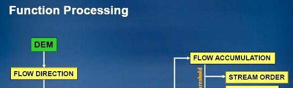
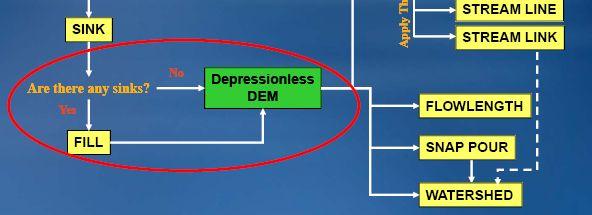
8 DEM Preprocessing (parent definition) Hydrologically correct DEM Flow direction (D8 method) Flow accumulation Stream definition and segmentation Watershed pre-delineation Project ( baby ) data extraction


9 Hydrological corrected DEM Sinks Some sinks are real Streams in the correct place: To burn or not to burn Watershed boundaries in the correct place To fence or not to fence


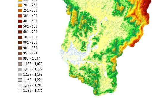
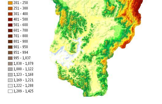
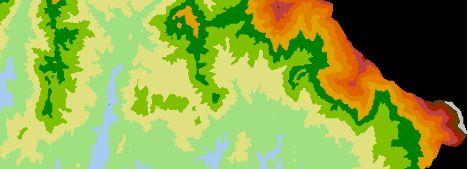
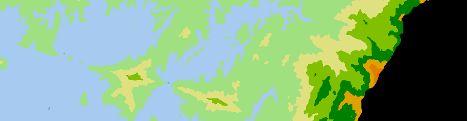
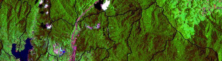
10 SRTM-DEM Topo -DEM of Klang river basin. SRTM-DEM

11 Stream definition and segmentation Threshold (performance) Watershed pre-pelineation At stream confluences DEM Preprocessing (cont.)


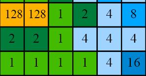
12 Flow direction processing Coding direction Elevation Flow direction


13 Flow accumulation processing Flow direction Coding direction Flow accumulation
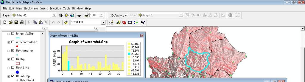
 Profile Interactive or batch processing Understanding of basin")
14 Watershed Delineation Flexible addition and removal of basin outlets Merge existing basins Split basin anywhere on the stream Add an outlet anywhere (trace the outlet stream to an existing stream) Profile Interactive or batch processing Understanding of basin character
15 Watershed delineation Delineate the contribution area to the cell or group of cell
16 Batch Subbasin Delineation Rule - The point should be located within the grid cell that has an existing stream. Import Batch Points Places all selected points in the map into the batch point file. Id source feature classes have Name and Description attributes, they area assigned to the batch points Delineate Batch Points Takes points from batch point feature class and uses them to do basin subdivision. BatchDone and SnapOn attributes to control snapping


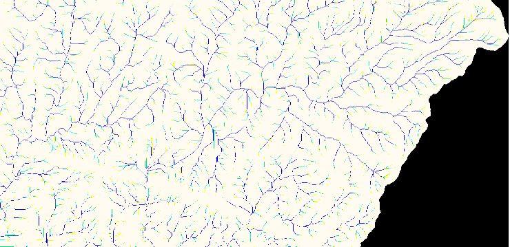
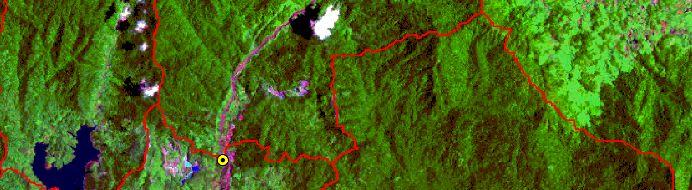
17 Bach processing Topo-DEM Batu Dam Klang Gate Dam
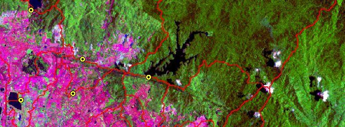
18 Bach processing SRTM-DEM
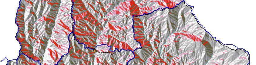
19 Bach processing SRTM-DEM
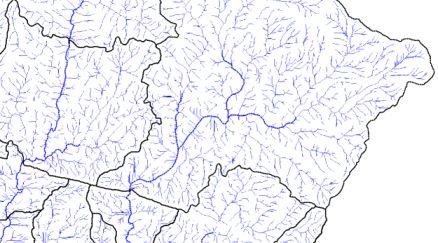
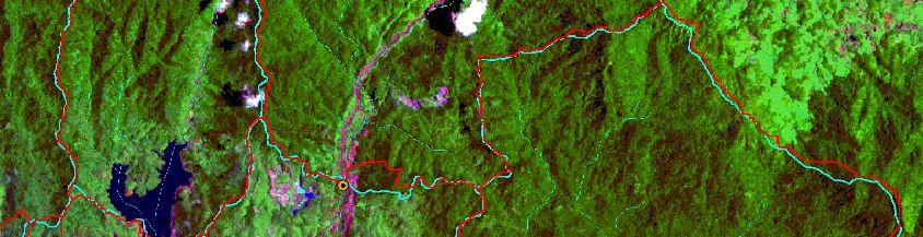
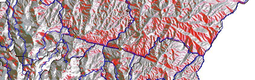
20 Improvement of Derived basin binderies based on the Bach processing using two sources of DEMs Delineated boundaries from SRTM-DEM Delineated boundaries from Topo-DEM Main rivers Diversions VIPs
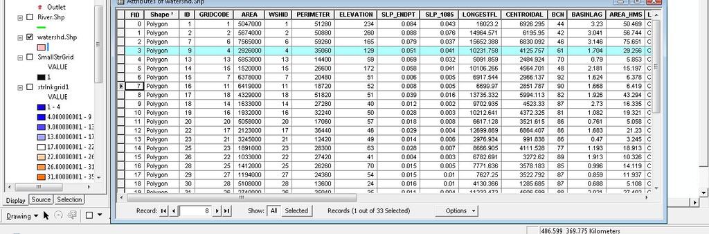
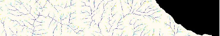
21 Extracting sub-basin database for KRB


22 Comparison o of some basic parameters a e r from two sourceso u r c e s Topo-DEM30 SRTM-DEM30 Name Perimeter km Elevation m Slope Perimeter % Area km 2 km Elevation m Slope % Area km 2 s s s s s s s s s s s s s s s s s s s s s s s s s s s s s s s s Min Max Avg STDEV Sum * * * * * * 4
23 Nash-Sutcliff Efficiency (NSE) coefficient (Nash and Sutcliffe, 1970) Where : Elevation, Area, Perimeter or slope derived from SRTM-DEM : Elevation, Area, Perimeter or slope derived from Topo-DEM : Mean Elevation, Area, Perimeter or slope derived from Topo-DEM NSE efficiency coefficient for elevation, area, slope and perimeter Elevation Area slope Perimeter
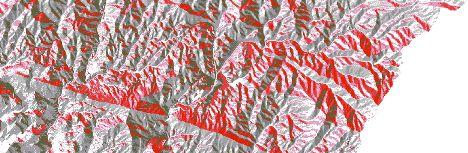
24 Conclusions: Nash-Sutcliff Efficiency (NSE) coefficients indicate similarity about 97%, 84%, 72% and 99% for basin area, perimeter, slope and centroid elevation respectively, when considering Topo-DEM as reference. From the analogy of two source of elevation dataset, this is drawn that SRTM-DEM can explain the Topo-DEM by 88 percent, which is reasonable estimation for such a large watershed. As can see in figure 3, delineated basin boundary using SRTM- DEM in flat urban areas are not as good as no urbanized areas. In particular, sub-basin s19, s23, s26, s27, s28, s31, s32 and s33 that are all situated in highly developed urban area, illustrate the largest discrepancy compared to the sub-basin boundary delineated by Topo-DEM. Good agreement is found for the area with high relief mostly in mountainous areas.
25 u Develop HMS inputs from GeoHMS u HMS Schematic u Basin Model u Background Map File u Grid Cell Parameter File
26


27 5-10 July 2009, Kyoto University, Kyoto, Japan Assemble an HMS model

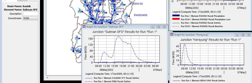
28 Running HEC-HMS

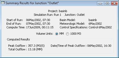
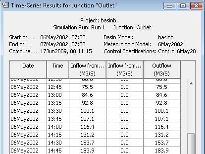
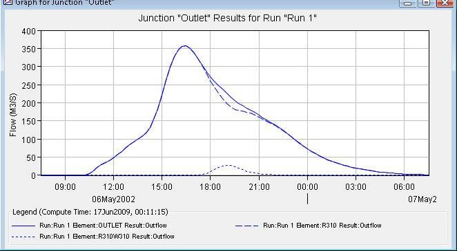
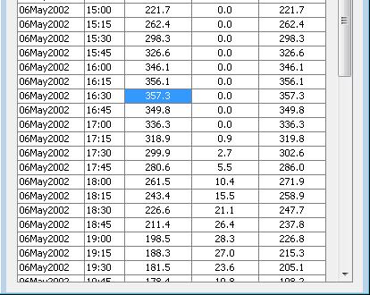
29 Showing the results
30 Thank you
A GIS-based Approach to Watershed Analysis in Texas Author: Allison Guettner
 Texas A&M University Zachry Department of Civil Engineering CVEN 658 Civil Engineering Applications of GIS Instructor: Dr. Francisco Olivera A GIS-based Approach to Watershed Analysis in Texas Author:
Automatic Watershed Delineation using ArcSWAT/Arc GIS
 Automatic Watershed Delineation using ArcSWAT/Arc GIS By: - Endager G. and Yalelet.F 1. Watershed Delineation This tool allows the user to delineate sub watersheds based on an automatic procedure using
International Journal of Advance Engineering and Research Development
 Scientific Journal of Impact Factor (SJIF): 4.72 International Journal of Advance Engineering and Research Development Volume 4, Issue 5, May -2017 Watershed Delineation of Purna River using Geographical
Creating Watersheds and Stream Networks. Steve Kopp
 Creating Watersheds and Stream Networks Steve Kopp Workshop Overview Demo Data Understanding the tools Elevation Data Types DEM : Digital Elevation Model bare Earth DSM : Digital Surface Model Data Structure
Hydrologic Engineering Applications of Geographic Information Systems
 Hydrologic Engineering Applications of Geographic Information Systems Davis, California Objectives: The participant will acquire practical knowledge and skills in the application of GIS technologies for
Hydrologic and Hydraulic Modeling with ArcGIS. Dean Djokic
 Hydrologic and Hydraulic Modeling with ArcGIS Dean Djokic (ddjokic@esri.com) Content Water resources issues Core GIS tools for surface water analysis DEM data and processing Arc Hydro Application tools
INTRODUCTION TO HEC-HMS
 INTRODUCTION TO HEC-HMS Hydrologic Engineering Center- Hydrologic Modeling System US Army Corps of Engineers Hydrologic Engineering Center HEC-HMS Uses Schematics Enter properties: watershed, rivers (reaches),
CATCHMENT AND OVERLAND FLOW PATHWAY DELINEATION USING LIDAR AND GIS GRID BASED APPROACH IN URBAN STORMWATER AND SEWER NETWORK MODELS
 CATCHMENT AND OVERLAND FLOW PATHWAY DELINEATION USING LIDAR AND GIS GRID BASED APPROACH IN URBAN STORMWATER AND SEWER NETWORK MODELS Thomas Joseph (AWT) ABSTRACT This paper presents specific examples comparing
EXTRACTING HYDROLOGIC INFORMATION FROM SPATIAL DATA
 EXTRACTING HYDROLOGIC INFORMATION FROM SPATIAL DATA FOR HMS MODELING By Francisco Olivera, 1 P.E., Associate Member, ASCE ABSTRACT: A methodology is presented for extracting topographic, topologic, and
StreamStats: Delivering Streamflow Information to the Public. By Kernell Ries
 StreamStats: Delivering Streamflow Information to the Public By Kernell Ries U.S. Department of the Interior U.S. Geological Survey MD-DE-DC District 410-238-4317 kries@usgs.gov StreamStats Web Application
HYDROLOGIC AND WATER RESOURCES EVALUATIONS FOR SG. LUI WATERSHED
 HYDROLOGIC AND WATER RESOURCES EVALUATIONS FOR SG. LUI WATERSHED 1.0 Introduction The Sg. Lui watershed is the upper part of Langat River Basin, in the state of Selangor which located approximately 20
MODULE 7 LECTURE NOTES 5 DRAINAGE PATTERN AND CATCHMENT AREA DELINEATION
 MODULE 7 LECTURE NOTES 5 DRAINAGE PATTERN AND CATCHMENT AREA DELINEATION 1. Introduction Topography of the river basin plays an important role in hydrologic modelling, by providing information on different
CE 394K.3 GIS in Water Resources Midterm Quiz Fall There are 5 questions on this exam. Please do all 5. They are of equal credit.
 Name: CE 394K.3 GIS in Water Resources Midterm Quiz Fall 2000 There are 5 questions on this exam. Please do all 5. They are of equal credit. 1. The ArcView Geographic Information System can display different
GIS in Water Resources Midterm Quiz Fall There are 5 questions on this exam. Please do all 5. They are of equal credit.
 Page 1 of 7 Name: GIS in Water Resources Midterm Quiz Fall 2004 There are 5 questions on this exam. Please do all 5. They are of equal credit. 1. In exercises in this class you have developed the skills
![)UDQFR54XHQWLQ(DQG'tD]'HOJDGR&](/thumbs/95/125846872.jpg ")UDQFR54XHQWLQ(DQG'tD]'HOJDGR&") &21&(37,21$1',03/(0(17$7,212)$1+
&21&(37,21$1',03/(0(17$7,212)$1+ Hydrologic and Hydraulic Analyses Using ArcGIS
 Hydrologic and Hydraulic Analyses Using ArcGIS Two day training class Overview ArcGIS and Arc Hydro provide strong foundation for support of hydrologic and hydraulic (H&H) analyses. This two-day course
Digital Elevation Model Based Hydro-processing
 Digital Elevation Model Based Hydro-processing B.H.P. Maathuis Department of Water Resources International Institute for Geo-information Science and Earth Observation (ITC) PO Box 6, 7500 AA Enschede,
Dr. S.SURIYA. Assistant professor. Department of Civil Engineering. B. S. Abdur Rahman University. Chennai
 Hydrograph simulation for a rural watershed using SCS curve number and Geographic Information System Dr. S.SURIYA Assistant professor Department of Civil Engineering B. S. Abdur Rahman University Chennai
Workshop: Build a Basic HEC-HMS Model from Scratch
 Workshop: Build a Basic HEC-HMS Model from Scratch This workshop is designed to help new users of HEC-HMS learn how to apply the software. Not all the capabilities in HEC-HMS are demonstrated in the workshop
Application of Geographical Information System (GIS) tools in watershed analysis
 tools in watershed analysis") Application of Geographical Information System (GIS) tools in watershed analysis Paritosh Gupta 1, Damanjit S Minhas 2, Rajendra M Tamhane 1, A K Mookerjee 2 1.ESRI India New Delhi 2. LEA Associates South
Application of Geographical Information System (GIS) tools in watershed analysis Paritosh Gupta 1, Damanjit S Minhas 2, Rajendra M Tamhane 1, A K Mookerjee 2 1.ESRI India New Delhi 2. LEA Associates South
Designing a Dam for Blockhouse Ranch. Haley Born
 Designing a Dam for Blockhouse Ranch Haley Born CE 394K GIS in Water Resources Term Paper Fall 2011 Table of Contents Introduction... 1 Data Sources... 2 Precipitation Data... 2 Elevation Data... 3 Geographic
Digital Elevation Models. Using elevation data in raster format in a GIS
 Digital Elevation Models Using elevation data in raster format in a GIS What is a Digital Elevation Model (DEM)? Digital representation of topography Model based on scale of original data Commonly a raster
NWT Open Report Delineation of Watersheds in the Mackenzie Mountains
 NWT Open Report 2015-007 Delineation of Watersheds in the Mackenzie Mountains K.L. Pierce and H. Falck Recommended Citation: Pierce, K.L. and Falck, H., 2015. Delineation of watersheds in the Mackenzie
Within this document, the term NHDPlus is used when referring to NHDPlus Version 2.1 (unless otherwise noted).
.") Exercise 7 Watershed Delineation Using ArcGIS Spatial Analyst Last Updated 4/6/2017 Within this document, the term NHDPlus is used when referring to NHDPlus Version 2.1 (unless otherwise noted). There
Exercise 7 Watershed Delineation Using ArcGIS Spatial Analyst Last Updated 4/6/2017 Within this document, the term NHDPlus is used when referring to NHDPlus Version 2.1 (unless otherwise noted). There
Hydrologic Modelling of the Upper Malaprabha Catchment using ArcView SWAT
 Hydrologic Modelling of the Upper Malaprabha Catchment using ArcView SWAT Technical briefs are short summaries of the models used in the project aimed at nontechnical readers. The aim of the PES India
Copyright. Hema Gopalan
 Copyright by Hema Gopalan 2003 WRAPHydro Data Model: Finding Input Parameters for the Water Rights Analysis Package by Hema Gopalan, B.E. Thesis Presented to the Faculty of the Graduate School of The University
Watershed Modeling With DEMs
 Watershed Modeling With DEMs Lesson 6 6-1 Objectives Use DEMs for watershed delineation. Explain the relationship between DEMs and feature objects. Use WMS to compute geometric basin data from a delineated
Rick Faber CE 513 Watershed and Streamwork Delineation Lab # 3 4/24/2006
 Rick Faber CE 513 Watershed and Streamwork Delineation Lab # 3 4/24/2006 1. Objective & Discussion: 2 To learn to use the ArcHydro tools to produce hydrologically descriptive data sets starting from a
Watershed Analysis of the Blue Ridge Mountains in Northwestern Virginia
 Watershed Analysis of the Blue Ridge Mountains in Northwestern Virginia Mason Fredericks December 6, 2018 Purpose The Blue Ridge Mountain range is one of the most popular mountain ranges in the United
CONVERTING A NEXRAD MAP TO A FLOODPLAIN MAP. Oscar Robayo, Tim Whiteaker, and David Maidment*
 CONVERTING A NEXRAD MAP TO A FLOODPLAIN MAP Oscar Robayo, Tim Whiteaker, and David Maidment* ABSTRACT: Using ArcGIS 9.0 ArcObjects and the new ModelBuilder environment, a methodology for converting a NEXRAD
Evaluation of gvsig and SEXTANTE Tools for Hydrological Analysis
 Evaluation of gvsig and SEXTANTE Tools for Hydrological Analysis 6th gvsig Conference, Valencia, SPAIN Prof. Dr-Ing Dietrich Schrödera Mudogah Hildahb and Franz Davidb Stuttgart University of Applied Sciences
GRAPEVINE LAKE MODELING & WATERSHED CHARACTERISTICS
 GRAPEVINE LAKE MODELING & WATERSHED CHARACTERISTICS Photo Credit: Lake Grapevine Boat Ramps Nash Mock GIS in Water Resources Fall 2016 Table of Contents Figures and Tables... 2 Introduction... 3 Objectives...
Assessment of a Rapid Approach for Estimating Catchment Areas for Surface Drainage Lines
 Assessment of a Rapid Approach for Estimating Catchment Areas for Surface Drainage Lines U.S. Geological Survey Center of Excellence for Geospatial Information Science 1400 Independence Road, Rolla Missouri,
Lidar-derived Hydrography as a Source for the National Hydrography Dataset
 Lidar-derived Hydrography as a Source for the National Hydrography Dataset Lidar-Derived Hydrography, Bathymetry, and Topobathymetry in the National Hydrography Dataset and 3-Dimensional Elevation Program
GIS in Water Resources Midterm Exam Fall 2008 There are 4 questions on this exam. Please do all 4.
 Page 1 of 8 Name: GIS in Water Resources Midterm Exam Fall 2008 There are 4 questions on this exam. Please do all 4. 1. Basic Concepts [20 points] Find the letter with the best answer for each term: 1.
Using GIS to Delineate Watersheds Ed Poyer NRS 509, Fall 2010
 Using GIS to Delineate Watersheds Ed Poyer NRS 509, Fall 2010 A watershed is an area that contributes flow to a point on the landscape. (Bolstad, 2005). Watersheds are an important focus of study because
4. GIS Implementation of the TxDOT Hydrology Extensions
 4. GIS Implementation of the TxDOT Hydrology Extensions A Geographic Information System (GIS) is a computer-assisted system for the capture, storage, retrieval, analysis and display of spatial data. It
Civil Engineering 394K: Topic 3 Geographic Information Systems (GIS) in Water Resources Engineering FALL 2014
 in Water Resources Engineering FALL 2014") Civil Engineering 394K: Topic 3 Geographic Information Systems (GIS) in Water Resources Engineering TERM PROJECT REPORT Reinvestigation of the Halloween Flood and Hydrologic Modeling of the Onion Creek
Civil Engineering 394K: Topic 3 Geographic Information Systems (GIS) in Water Resources Engineering TERM PROJECT REPORT Reinvestigation of the Halloween Flood and Hydrologic Modeling of the Onion Creek
software, just as word processors or databases are. GIS was originally developed and cartographic capabilities have been augmented by analysis tools.
 1. INTRODUCTION 1.1Background A GIS is a Geographic Information System, a software package for creating, viewing, and analyzing geographic information or spatial data. GIS is a class of software, just
Automated Hydrologic and Hydraulic Modeling of a Hydroelectric System UC1131 July 2012
 Automated Hydrologic and Hydraulic Modeling of a Hydroelectric System UC1131 July 2012 Author: Eok Ngo, Integrated Spatial Solutions, Inc. Contact: engo@issi-gis.com ABSTRACT Balancing the needs of regulatory
SUB CATCHMENT AREA DELINEATION BY POUR POINT IN BATU PAHAT DISTRICT
 SUB CATCHMENT AREA DELINEATION BY POUR POINT IN BATU PAHAT DISTRICT Saifullizan Mohd Bukari, Tan Lai Wai &Mustaffa Anjang Ahmad Faculty of Civil Engineering & Environmental University Tun Hussein Onn Malaysia
Hydrology and Watershed Analysis
 Hydrology and Watershed Analysis Manual By: Elyse Maurer Reference Map Figure 1. This map provides context to the area of Washington State that is being focused on. The red outline indicates the boundary
Watershed Delineation in GIS Environment Rasheed Saleem Abed Lecturer, Remote Sensing Centre, University of Mosul, Iraq
 Watershed Delineation in GIS Environment Rasheed Saleem Abed Lecturer, Remote Sensing Centre, University of Mosul, Iraq Abstract: The management and protection of watershed areas is a major issue for human
Hydrological modelling of the Lena River using SWIM
 Hydrological modelling of the Lena River using SWIM Michel Wortmann 1 1 Potsdam Institute for Climate Impact Research (PIK), Germany July 8, 214 Contents 1 The Lena catchment and data used 1 1.1 Discharge
Chapter 10 - Sacramento Method Examples
 Chapter 10 Sacramento Method Examples Introduction Overview This chapter presents two example problems to demonstrate the use of the Sacramento method. These example problems use the SACPRE and HEC-1 computer
Determination of Urban Runoff Using ILLUDAS and GIS
 Texas A&M University Department of Civil Engineering Instructor: Dr. Francisco Olivera CVEN689 Applications of GIS to Civil Engineering Determination of Urban Runoff Using ILLUDAS and GIS Tae Jin Kim 03.
Floodplain modeling. Ovidius University of Constanta (P4) Romania & Technological Educational Institute of Serres, Greece
 Romania & Technological Educational Institute of Serres, Greece") Floodplain modeling Ovidius University of Constanta (P4) Romania & Technological Educational Institute of Serres, Greece Scientific Staff: Dr Carmen Maftei, Professor, Civil Engineering Dept. Dr Konstantinos
Floodplain modeling Ovidius University of Constanta (P4) Romania & Technological Educational Institute of Serres, Greece Scientific Staff: Dr Carmen Maftei, Professor, Civil Engineering Dept. Dr Konstantinos
MODELING STUDIES WITH HEC-HMS AND RUNOFF SCENARIOS IN YUVACIK BASIN, TURKIYE
 MODELING STUDIES WITH HEC-HMS AND RUNOFF SCENARIOS IN YUVACIK BASIN, TURKIYE Yener, M.K. Şorman, A.Ü. Department of Civil Engineering, Middle East Technical University, 06531 Ankara/Türkiye Şorman, A.A.
GIS Techniques for Floodplain Delineation. Dean Djokic
 GIS Techniques for Floodplain Delineation Dean Djokic (ddjokic@esri.com) Content What is a floodplain? How to get a floodplain? What can GIS do for floodplain modeling? Simple GIS techniques for floodplain
Development of GIS Tools to Optimize Identification of Road Segments Prone to Flood Damage
 A Report from the University of Vermont Transportation Research Center Development of GIS Tools to Optimize Identification of Road Segments Prone to Flood Damage Final Report TRC Report 15-005 September
13 Watershed Delineation & Modeling
 Module 4 (L12 - L18): Watershed Modeling Standard modeling approaches and classifications, system concept for watershed modeling, overall description of different hydrologic processes, modeling of rainfall,
Using ArcGIS for Hydrology and Watershed Analysis:
 Using ArcGIS 10.2.2 for Hydrology and Watershed Analysis: A guide for running hydrologic analysis using elevation and a suite of ArcGIS tools Anna Nakae Feb. 10, 2015 Introduction Hydrology and watershed
GIS in Water Resources Midterm Quiz Fall There are 5 questions on this exam. Please do all 5. They are of equal credit.
 Name: GIS in Water Resources Midterm Quiz Fall 2003 There are 5 questions on this exam. Please do all 5. They are of equal credit. 1. Data Representation (a) In ArcGIS, vector and tabular data have a number
Base Level Engineering FEMA Region 6
 Base Level Engineering Over the past five years, has been evaluating its investment approach and data preparation work flow to establish an efficient and effective change in operation, generating an approach
The National Hydrography Dataset in the Pacific Region. U.S. Department of the Interior U.S. Geological Survey
 The National Hydrography Dataset in the Pacific Region U.S. Department of the Interior U.S. Geological Survey The National Map The National Map is built on partnerships and standards The National Map consists
A hierarchical network-based algorithm for multi-scale watershed delineation
 This is an Accepted Manuscript of an article published in the Journal of Computers & Geosciences in 2014, available online: doi:10.1016/j.cageo.2014.07.014 A hierarchical network-based algorithm for multi-scale
ENGRG Introduction to GIS
 ENGRG 59910 Introduction to GIS Michael Piasecki March 17, 2014 Lecture 08: Terrain Analysis Outline: Terrain Analysis Earth Surface Representation Contour TIN Mass Points Digital Elevation Models Slope
Creating Watersheds from a DEM
 Creating Watersheds from a DEM These instructions enable you to create watersheds of specified area using a good quality Digital Elevation Model (DEM) in ArcGIS 8.1. The modeling is performed in ArcMap
Evaluation of gvsig and SEXTANTE Tools for Hydrological Analysis Schröder Dietrich a, Mudogah Hildah b and Franz David b
 Evaluation of gvsig and SEXTANTE Tools for Hydrological Analysis Schröder Dietrich a, Mudogah Hildah b and Franz David b ab Photogrammetry and Geo-informatics Masters Programme, Stuttgart University of
Influence of spatial variation in precipitation on artificial neural network rainfall-runoff model
 Hydrology Days 212 Influence of spatial variation in precipitation on artificial neural network rainfall-runoff model André Dozier 1 Department of Civil and Environmental Engineering, Colorado State University
Model Integration - How WEPP inputs are calculated from GIS data. ( ArcGIS,TOPAZ, Topwepp)
") Model Integration - How WEPP inputs are calculated from GIS data. ( ArcGIS,TOPAZ, Topwepp) ArcGIS 9.1-9.3 Allows user to locate area of interest, assemble grids, visualize outputs. TOPAZ Performs DEM
Model Integration - How WEPP inputs are calculated from GIS data. ( ArcGIS,TOPAZ, Topwepp) ArcGIS 9.1-9.3 Allows user to locate area of interest, assemble grids, visualize outputs. TOPAZ Performs DEM
MODULE 8 LECTURE NOTES 2 REMOTE SENSING APPLICATIONS IN RAINFALL-RUNOFF MODELLING
 MODULE 8 LECTURE NOTES 2 REMOTE SENSING APPLICATIONS IN RAINFALL-RUNOFF MODELLING 1. Introduction The most common application of the remote sensing techniques in the rainfall-runoff studies is the estimation
Setting up SWAT to quantify water-related ecosystem services in a large East African watershed
 Benedikt Notter, University of Bern, Switzerland Setting up SWAT to quantify water-related ecosystem services in a large East African watershed 5th International SWAT Conference August 5 7, Boulder, Colorado
Watershed Delineation
 Watershed Delineation Jessica L. Watkins, University of Georgia 2 April 2009 Updated by KC Love February 25, 2011 PURPOSE For this project, I delineated watersheds for the Coweeta synoptic sampling area
HyGIS-Qual2E: Flexible Coupling of Water Quality Model with GIS
 HyGIS-Qual2E: Flexible Coupling of Water Quality Model with GIS Sung-Ryong HA*, In-Hyeok PARK Abstract This paper aims to develop a program HyGIS-Qual2E by which an input data file of the river water quality
EMERGENCY PLANNING IN NORTHERN ALGERIA BASED ON REMOTE SENSING DATA IN RESPECT TO TSUNAMI HAZARD PREPAREDNESS
 EMERGENCY PLANNING IN NORTHERN ALGERIA BASED ON REMOTE SENSING DATA IN RESPECT TO TSUNAMI HAZARD PREPAREDNESS Barbara Theilen-Willige Technical University of Berlin, Institute of Applied Geosciences Department
A Simple Drainage Enforcement Procedure for Estimating Catchment Area Using DEM Data
 A Simple Drainage Enforcement Procedure for Estimating Catchment Area Using DEM Data David Nagel, John M. Buffington, and Charles Luce U.S. Forest Service, Rocky Mountain Research Station Boise Aquatic
Floodplain and Flood Probability Mapping Using Geodatabases
 Brigham Young University BYU ScholarsArchive All Theses and Dissertations 2005-03-16 Floodplain and Flood Probability Mapping Using Geodatabases Douglas J. Gallup Brigham Young University - Provo Follow
A Comparison of Manual and Computer-Assisted Drainage Delineation Methods for Hydrologic-Unit Map Development
 This paper was peer-reviewed for scientific content. Pages 1118-1127. In: D.E. Stott, R.H. Mohtar and G.C. Steinhardt (eds). 2001. Sustaining the Global Farm. Selected papers from the 10th International
GIS in Water Resources Exercise #4 Solution Prepared by Irene Garousi-Nejad and David Tarboton
 GIS in Water Resources Exercise 4 Solution Prepared by Irene Garousi-Nejad and David Tarboton 1. Cell length (N-S) in m, width (E-W) in m, area in m 2 for the DEM cells in the merged DEM. N-S y = R e φ
Development of the Hydrologic Model
 Kick-off meeting on enhancing hydrological data management and exchange procedures Water and Climate Adaptation Plan (WATCAP) for Sava River Basin Development of the Hydrologic Model David Heywood Team
Delineation of the Watersheds Basin in the Konya City and Modelling by Geographical Information System
 Delineation of the Watersheds Basin in the Konya City and Modelling by Geographical Information System Nahida Hameed Hamza Alqaysi a,b,, Mushtaq Abdulameer Alwan Almuslehi a a Environmental Engineering
ENGRG Introduction to GIS
 ENGRG 59910 Introduction to GIS Michael Piasecki November 17, 2017 Lecture 11: Terrain Analysis Outline: Terrain Analysis Earth Surface Representation Contour TIN Mass Points Digital Elevation Models Slope
ISSN Vol.03,Issue.10 May-2014, Pages:
 www.semargroup.org, www.ijsetr.com ISSN 2319-8885 Vol.03,Issue.10 May-2014, Pages:2187-2191 YIN YIN HTWE 1, AYE AYE THANT 2 1 Dept of Civil Engineering, Mandalay Technological University, Mandalay, Myanmar,
TABLE OF CONTENTS CHAPTER NO. TITLE PAGE NO. LIST OF TABLES LIST OF FIGURES LIST OF SYMBOLS AND ABBREVIATIONS
 ix TABLE OF CONTENTS CHAPTER NO. TITLE PAGE NO. ABSTRACT LIST OF TABLES LIST OF FIGURES LIST OF SYMBOLS AND ABBREVIATIONS iii xiii xiv xx 1 INTRODUCTION 1 1.1 GENERAL 1 1.2 THE PROBLEM STATEMENT 3 1.3
How to Create Stream Networks using DEM and TauDEM
 How to Create Stream Networks using DEM and TauDEM Take note: These procedures do not describe all steps. Knowledge of ArcGIS, DEMs, and TauDEM is required. TauDEM software ( http://hydrology.neng.usu.edu/taudem/
ELEMENTS OF DECISION SUPPORT SYSTEM FOR FLOOD CONTROL IN THE NYSA KŁODZKA CATCHMENT
 ELEMENTS OF DECISION SUPPORT SYSTEM FOR FLOOD CONTROL IN THE NYSA KŁODZKA CATCHMENT KAEiOG 2005, 295-303 Jarosław J. Napiórkowski Institute of Geophysics, Polish Academy of Sciences ul. Księcia Janusza
Notes to project: Conflict and cooperation over shared water resources
 Notes to project: Conflict and cooperation over shared water resources Jan Ketil Rød Department of geography, NTNU jan.rod@svt.ntnu.no Version: 30/06/2006 Abstract This note outlines various dataset that
ArcHYDRO: GIS for Water Resources
 SOCRATES ERASMUS Intensive Programme ArcHYDRO: GIS for Water Resources Source: Center for Research in Water Resources, University of Texas at Austin Tutorial: Watershed and Stream Network Delineation Goals
Morphometric Analysis of Didessa River Catchment in Blue Nile Basin, Western Ethiopia
 DOI: http://dx.doi.org/10.4314/star.v3i3.31 ISSN: 2226-7522(Print) and 2305-3372 (Online) Science, Technology and Arts Research Journal Sci. Technol. Arts Res. J., July-Sep 2014, 3(3): 191-197 Journal
Extraction of Drainage Pattern from ASTER and SRTM Data for a River Basin using GIS Tools
 2012 International Conference on Environment, Energy and Biotechnology IPCBEE vol.33 (2012) (2012) IACSIT Press, Singapore Extraction of Drainage Pattern from ASTER and SRTM Data for a River Basin using
CHAPTER V WATERSHED CHARACTERIZATION USING GIS
 61 CHAPTER V WATERSHED CHARACTERIZATION USING GIS 5.1 GENERAL: In this chapter, introduction to watershed characterization and analysis has been presented in the first part. Methodology to compute important
DESCRIPTION OF A HYDROLOGIC DATASET. Department of Environmental Sciences, Wageningen University and. Research Center. Wageningen, The Netherlands
 DESCRIPTION OF A HYDROLOGIC DATASET FOR THE BRISY SUBCATCHMENT R. T. Oosterho? and C. Paniconi y? Department of Environmental Sciences, Wageningen University and Research Center Wageningen, The Netherlands
Creating Watersheds from a DEM in ArcGIS 9.x
 Creating Watersheds from a DEM in ArcGIS 9.x These instructions enable you to create watersheds (a.k.a. catchments or basins) using a good quality Digital Elevation Model (DEM) in ArcGIS 9.1. The modeling
Bushkill Creek 3 rd Street Dam Removal Analysis
 Bushkill Creek 3 rd Street Dam Removal Analysis HEC HMS Runoff and Routing Model Stephen Beavan, Melanie DeFazio, David Gold, Peter Mara and Dan Moran CE 421: Hydrology Fall 2010 December 15, 2010 Contents
Watershed Application of WEPP and Geospatial Interfaces. Dennis C. Flanagan
 Watershed Application of WEPP and Geospatial Interfaces Dennis C. Flanagan Research Agricultural Engineer USDA-Agricultural Research Service Adjunct Professor Purdue Univ., Dept. of Agric. & Biol. Eng.
BSEN 6220 GIS LAB #5
 BSEN 6220 GIS LAB #5 Dustin Till 10/29/2014 INTRODUCTION: ArcGIS is a geographic information system for working with maps and geographic information. It is used for creating and using maps, compiling geographic
MAPPING POTENTIAL LAND DEGRADATION IN BHUTAN
 MAPPING POTENTIAL LAND DEGRADATION IN BHUTAN Moe Myint, Geoinformatics Consultant Rue du Midi-8, CH-1196, Gland, Switzerland moemyint@bluewin.ch Pema Thinley, GIS Analyst Renewable Natural Resources Research
Streams in the Ranching Country of South Texas
 Streams in the Ranching Country of South Texas Watershed Analysis of HUC 12110207 Sandranell Moerbe CE GIS in Water Resources Fall 2015 INTRODUCTION This project investigates the portion of South Texas
Rapid Flood Mapping Using Inundation Libraries
 Rapid Flood Mapping Using Inundation Libraries Jude Kastens, Kevin Dobbs, James Halgren, Katherine Balster 2017 ASFPM Conference May 3, 2017 5 mi Kansas River Valley between Manhattan and Topeka Email:
Hydrologic Evaluation of the Blanchard River
 Hydrologic Evaluation of the Blanchard River Hancock County Flood Risk Reduction Program Prepared for: Maumee Watershed Conservancy District 1464 Pinehurst Dr. Defiance, Ohio 43512 Prepared by: Stantec
GIS feature extraction tools in diverse landscapes
 CE 394K.3 GIS in Water Resources GIS feature extraction tools in diverse landscapes Final Project Anna G. Kladzyk M.S. Candidate, Expected 2015 Department of Environmental and Water Resources Engineering
GIS Geographic Information System
 GIS Geographic Information System Andrea Petroselli Tuscia University, Italy petro@unitus.it SUMMARY Part 1: Part 2: Part 3: Part 4: What is a GIS? Why do we need a GIS? Which are the possibilities of
Current and Future Plans. R. Srinivasan
 Current and Future Plans R. Srinivasan Contents 1 The ArcSWAT Interface 2 VizSWAT: Output Visualization 3 User online support 4 MapWindows SWAT interface 5 ArcGIS SWAT/APEX interfaces 6 Radar Rainfall
Trail Flow: Analysis of Drainage Patterns Affecting a Mountain Bike Trail
 Andy Belcher BAE 590 Professor Huffman 12.9.11 Location Trail Flow: Analysis of Drainage Patterns Affecting a Mountain Bike Trail The location of the project area rests in the Cary area of Wake County,
Basin characteristics
 Basin characteristics From hydrological processes at the point scale to hydrological processes throughout the space continuum: point scale à river basin The watershed characteristics (shape, length, topography,
Exercise 4. Watershed and Stream Network Delineation
 Exercise 4. Watershed and Stream Network Delineation GIS in Water Resources, Fall 2018 Prepared by David G Tarboton and David R. Maidment Revised 9 October, 2018 Purpose The purpose of this exercise is
Extraction of Watershed Characteristics using GIS and Digital Elevation Model
 International Journal of Engineering Science Invention ISSN (Online): 2319 6734, ISSN (Print): 2319 6726 Volume 6 Issue 7 July 2017 PP. 01-06 Extraction of Watershed Characteristics using GIS and Digital
A SIMPLE GIS METHOD FOR OBTAINING FLOODED AREAS
 A SIMPLE GIS METHOD FOR OBTAINING FLOODED AREAS ROMAN P., I. 1, OROS C., R. 2 ABSTRACT. A simple GIS method for obtaining flooded areas. This paper presents a method for obtaining flooded areas near to
How to integrate wetland processes in river basin modeling? A West African case study
 How to integrate wetland processes in river basin modeling? A West African case study stefan.liersch@pik-potsdam.de fred.hattermann@pik-potsdam.de June 2011 Outline Why is an inundation module required?