Coastal Landforms and Processes
|
|
|
- Kristian Spencer
- 6 years ago
- Views:
Transcription

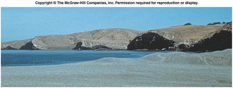
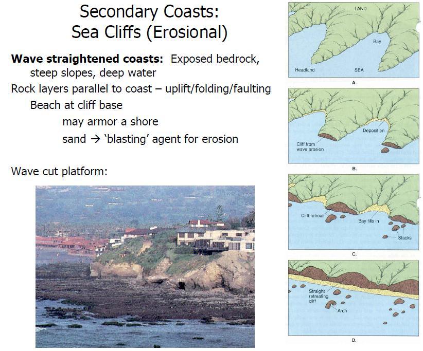
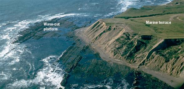
1 Coastal Landforms and Processes Waves, Tides and Shallow Water Processes Littoral Zone Beaches & Seasonal Cycles Barrier Islands Beach Ridges Spits Deltas Coastal Cliffs Marine Terraces Wave-Cut Scarps Sea Level Fluctuations Barrier Island Migration Coastal Diversity Hawaiian coastline Photo source: SCGS 1

, storm surges, winds, waves reef builders, filter feeders,")
2 Factors Influencing Coastal Geomorphology Wind direct influence: saltation, dunes/blowouts indirect influence: wave generation, ocean circulation setup - setdown Seiches: Storms: Biology: lakes, estuaries, small seas, created by changes in barometric pressure, violent storms and tides. tropical, extratropical (Noreasters), storm surges, winds, waves reef builders, filter feeders, grasses/wetlands etc.


3 Sea Level Changes Sea level changes are easily determined from water level gauges. Few gauges have data extending back 50/100 years Eustatic: global sea level changes associated with the addition or removal of water (15 cm/century 23 cm/century) Relative: sea level changes relative to a local datum, incorporates tectonic influences

4 Sea Level Changes

5 Features and landforms range in size from centimeters to kilometers and are formed or modified over time scales of minutes to millennia.

6 Wave Formation: Speed, fetch, duration Fully developed sea state Dispersion
 setup/setdown Wave Refraction: changes in the direction")

7 Shallow Water Processes: shoaling, refraction, diffraction, reflection, breaking, wave(wind) setup/setdown Wave Refraction: changes in the direction of wave propagation due to along crest variations in wave speed Wave Rays: lines drawn perpendicular to the crest of the wave in the direction of wave propagation
 Submarine Canyon: spreading of wave energy throughout the depression (c) Headland: focusing of wave energy (d) Ebb-Shoal:")
8 Wave Refraction Parallel Contours: refraction results in wave rays approaching normal to shoreline = (wave crests parallel to shoreline (a)) (a) Submarine Ridge: focusing of wave energy toward the ridge (b) Submarine Canyon: spreading of wave energy throughout the depression (c) Headland: focusing of wave energy (d) Ebb-Shoal: (b) (c) (d)


9 Wave Diffraction: bending of wave crests (changes in direction) due to along crest gradients in wave height

10 Wave Breaking Surf Similarity Parameter Deep Water Wave Height Beach Slope Deep Water Wave Length


11 Nearshore Currents: longshore cross-shore rip currents undertow wave/wind setup


12 Rip Current bathymetric control hydrodynamic control relation to morphology

13 Undertow: xshore pressure gradient velocity decreases offshore deposition of material sand bar formation

14 Tidal forces Tides enhanced during full Moon and new Moon Sun-Moon-Earth closely aligned
15 Influence of Perigee, Apogee, Perihelion and Aphelion on the Earth s Tides Stronger for perigee and perihelion

16 Lunar Cycle

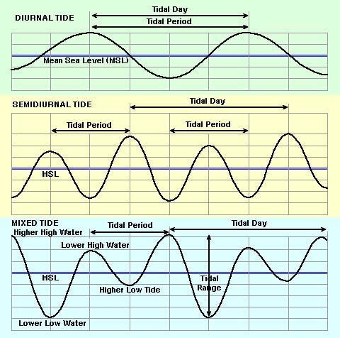
17 Tides: (diurnal, semi-diurnal, mixed) The periodic change in water level results in different parts of the foreshore being exposed to wave energy throughout the day. In regions with large tidal ranges, the water may rise and fall 10 m, and the shoreline may move laterally several kilometers between high and low water. Different region of the intertidal zone are exposed to erosion and deposition. tidal currents can erode and transport sediment. residual motions can be highly important and spatially asymmetric patterns of ebb and flood stages may cause mass transport of both water and sediment. tides cause the draining and filling of tidal bays, an important process related to the cutting and migration of tidal inlets and the formation of flood- and ebb-tidal shoals in barrier coasts.
18


19 Tidal Range Classification Microtidal, < 2 m. Mesotidal, 2-4 m. Macrotidal, > 4 m.


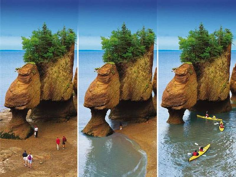
20 Bay of Fundy, Nova Scotia


21 Georges Bank, Gulf of Maine
: Tide-dominated (high).")
22 Hayes (1979) classification was based primarily on shores with low to moderate wave power and was intended to be applied to trailing edge, depositional coasts. Five shoreline categories were identified based on the relative influence of tide range versus mean wave height (Nummedal and Fischer 1978; Hayes 1979; Davis and Hayes 1984): Tide-dominated (high). Tide-dominated (low). Mixed-energy (tide-dominated). Shinnecock Inlet Mixed energy (wave-dominated). Wave-dominated.
23 Coastal zone: is defined as the transition zone where the land meets water, the region that is directly influenced by marine hydrodynamic processes. The coastal zone extends offshore to the continental shelf break and onshore to the first major change in topography above the reach of major storm waves. The CZ is divided into four subzones: (1) Coast. (2) Shore. (3) Shoreface. (4) Continental shelf.
24 Coast: a strip of land of indefinite width that extends from the coastline inland as far as the first major change in topography. Cliffs, frontal dunes, or a line of permanent vegetation usually mark this inland boundary. On barrier coasts, the distinctive back-barrier lagoon/marsh/tidal creek complex is considered part of the coast.
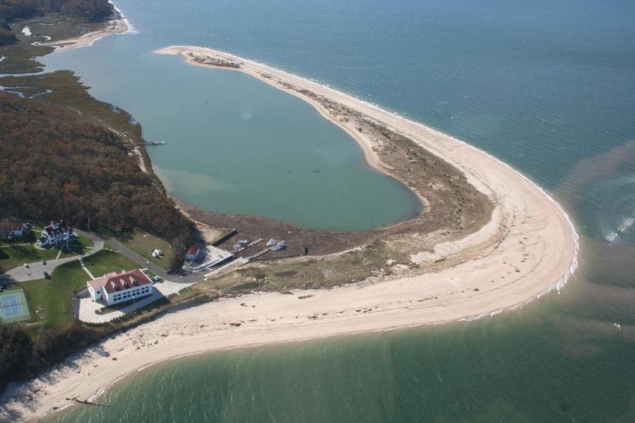
25 The shore: extends from the low-water line to the normal landward limit of storm wave effects. divided into two zones: backshore (berm) and foreshore (beach face). Foreshore: low-water line to the limit of wave uprush at high tide. Berm crest: marks the juncture of the foreshore and backshore.
26 Shoreface: seaward-dipping zone that extends from the low-water line offshore to the beginning of the continental shelf (slope transition, depth of no motion, end of the littoral zone). The shoreface is not found in all coastal zones
.")
27 The shoreface can be delineated from shore perpendicular profile surveys or from bathymetric charts (if they contain sufficient soundings in shallow water). The shoreface is the zone of most frequent and vigorous sediment transport.


28 Continental shelf: the shallow seafloor that borders most continents. Extends from the toe of the shoreface to the shelf break where the steeply inclined continental slope begins. It has been common practice to subdivide the shelf into inner-, mid-, and outer zones, although there are no regularly occurring geomorphic features on most shelves that suggest a basis for these subdivisions.
29 Littoral Zone The littoral zone extends inland to the highest water line during storms and seaward to the furthest area where wave processes stop influencing sediment transport and deposition on the seafloor (shoreface, depth of no motion).

,")
30 Littoral Drift all longshore transport within the littoral zone swash transport (beach drift), surfzone transport

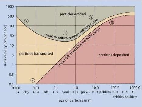
31 Sediment Transport


32 Depositional landforms. Beaches Most often associated with sand-sized quartz grains, shells or shell hash. Dependent on source of material (volcanic, coral, gravel etc.) Seasonal/storm cycles of evolution, accretion: wider higher during calm summer months, deflation: narrow, low profile during storm season. Stable, Erosional, Acretional 32


33 Beach Dynamics: Summer: gentler waves move sand shoreward Winter: large storm waves remove sand to offshore bars

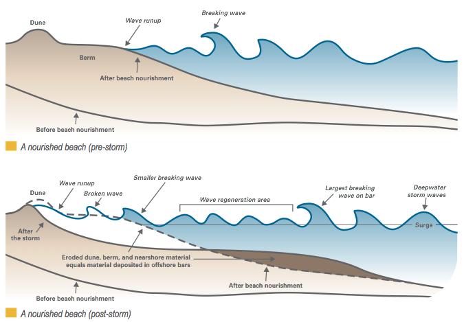
34 Seasonal Cycles: Winter/Storm Profile

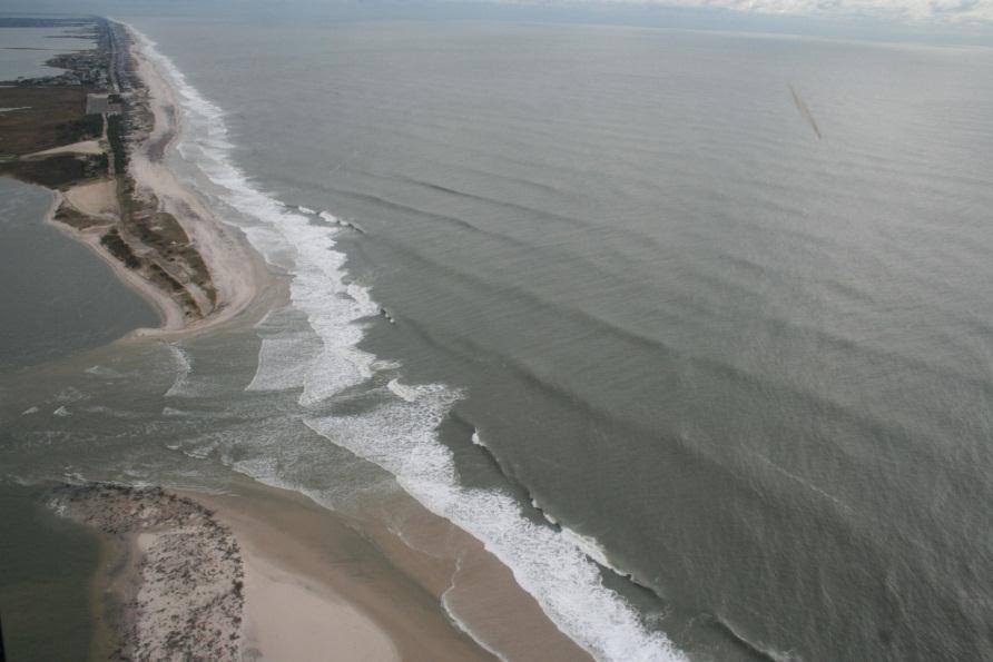
35 Barrier and Spit Formation

36 Spit Building Fire Island Inlet
37
38


39 Beach Ridges Beach ridges are wave-deposited ridges that form parallel to the coastline. They are composed of gravel, sands, and shell fragments, and in some cases they may be capped by aeolian sands blown from the beach. Source: Google


40 Deltas Coastal Geomorph Controls Discharge Tides Waves Sediment Characteristics 40
41 Deltas 41
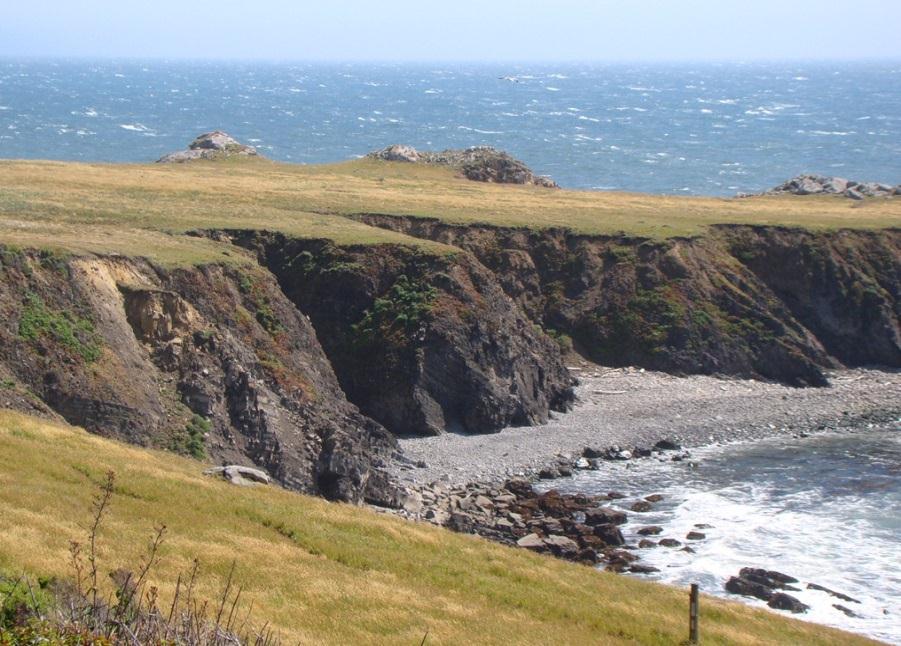
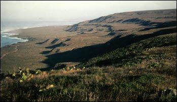
42
43
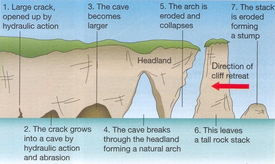
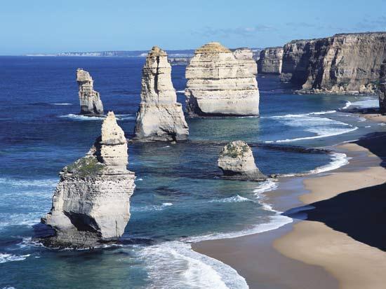
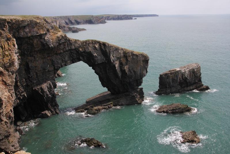
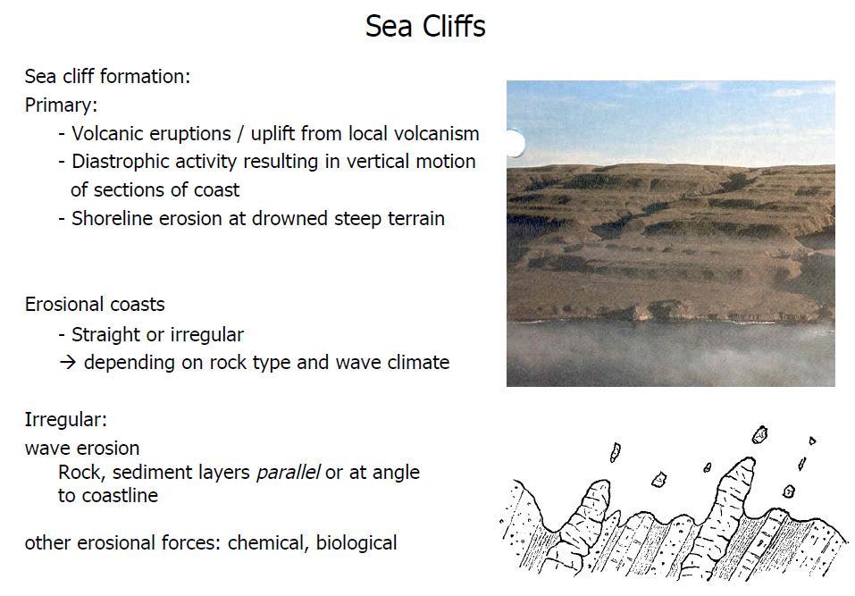
44 Differential Erosion: Sea Arch, Stacks 44

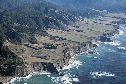
45 Marine Terraces
46 Coastal Diversity: Long Island Amero-Trailing Edge Coast South Shore Significant Wave Conditions: H ~= 1.5 m, T = 8 sec Micro-Meso Tidal Environments Tide Dominated & Riverine Gravel, sand Tide Dominated Cliff or Bluff Coast 2 m Gravel Wave Dominated Sand Barrier Island Mixed Energy
47 Atlantic North: Glaciated Coast Coasts are deeply indented and bordered by numerous rocky islands. The embayments usually have straight sides and deep water as a result of erosion by the glaciers. Uplifted terraces as a result of isostatic rebound. Moraines, drumlins, and sand dunes, the result of reworking outwash deposits, are common features. Glaciated coasts in North America extend from the New York City area north to the Canadian Arctic, on the west coast, from Seattle, Washington, north to the Aleutian Islands, and in the Great Lakes. (Shepard 1982).
48 Atlantic Central & South: Barrier and Drowned Valley Coasts The Atlantic coastal plain, features almost continuous barriers interrupted by inlets and by large embayments with dendritic drowned river valleys, the largest being Delaware and Chesapeake Bays. Extensive wetlands and marshes mark much of the coast, where sediment and marsh vegetation have partly filled the lagoons behind the barriers. The best exhibit of cuspate forelands in the world extends from the mouth of Chesapeake Bay to Cape Romain, South Carolina. Extensive development along the southeast coast of Florida. From Miami through eastern Louisiana, coastal characteristics alternate between swampy coast and white sand barriers.

49 North American has over 10,000 km of barriers, 1/3 of all barrier coast of the world.
50

51 The Atlantic & Gulf of Mexico: Coral and Mangrove Coasts The barrier islands change from quartz sand south of Miami to carbonate-dominated sand, eventually transforming into coral keys and mangrove forest. Live reefs along the east and south side of the keys and the shallows of Florida Bay studded with mangrove islands extending north and west into the Everglades and the Ten Thousand Islands area that comprises the lower Florida Gulf of Mexico coast.
52 Gulf of Mexico: Wetland Mangrove, and Barrier Coasts Sand supply is limited (limestone bedrock), so barriers are present only where there is a significant source, otherwise the coast is characterized by swamps. Enclosed bays usually have an abundance of mangrove islands and the topography is low with many lakes and marshes. Low wave energy environment. The Mississippi River has built a series of deltas into the Gulf of Mexico, the most recent Balize Delta (bird foot) has an average age of 1500 years. Most of the greater Mississippi delta is marshland and mud flats, with numerous shallow lakes and intertwining channels.

53 Gulf of Mexico West: Barrier Coast Barrier Island become the dominant coastal feature from the Mississippi Delta through Texas. Some of the longest barrier islands in the world are located along the Texas coast. Padre Island and Mustang Island, combined, extend for 208 km and feature extensive dune fields behind the broad beaches. The dunes rarely rise more than 10 m in height, and many marshy washover deltas have extended into the large lagoons behind the barriers. Extreme wind driven circulation. A large part of Laguna Madre is only inundated during flood periods or when the wind blows water from Corpus Christi Bay onto the flats.
54
55 Pacific: Sea Cliffs and Terraced Coasts Low sea cliffs bordered by terraces and a few coastal plains and deltas compose the coasts of southern California. Sea cliffs in this area are actively eroding, particularly in areas where they have been cut into alluvium. Despite the presence of a series of regional mountain ranges that cut across the coast, the rugged central and northern California coast is one of the straightest in the world. This area has high cliffs with raised marine terraces. A few broad river valleys interrupt the mountainous coast.

56 Pacific: Sea Cliffs and Terraced Coasts North of Cape Mendocino, the coast trends almost directly north, through Oregon and Washington, to the Strait of Juan de Fuca. Barriers or spits have formed at river mouths. Because of the North Pacific Ocean harsh wave climate, all of the major cities in Oregon and Washington were founded in sheltered water bodies.
57
58 The Bering & Chukchi Seas: Arctic Coastal Plains & Barriers The volcanic Aleutian Mountains extend some 2200 km (1370 miles) forming the border between the Pacific Ocean and the Bering Sea. Beyond the Alaska Peninsula and bordering the Bering Sea, extensive coastal plains are found with numerous lakes and meandering streams. The Yukon River has formed a large delta with many old lobes that form a vast plain connecting small, elevated tracts. In the north permafrost melting in summer creates thaw lakes. North of Kotzebue Sound, barriers and cuspate forelands border the coast.

59 The Beaufort Sea: Deltaic Coast East of Point Barrow, the coast is dominated by river deltas. Rivers draining the Brooks Range and the northern Canadian Rockies, built these deltas even though the rivers flow only a short period each year. Where the deltas are not actively building into the sea, extensive barrier islands can be found.
60 About 20 percent of the 1,650 km of shore on the main islands is sandy beach. The Hawaiian Islands are the tops of volcanic mountains rising above the ocean floor about five km below the water surface. These volcanoes formed over a localized hot spot of magma generation. As the older volcanoes formed great shields and died, the movement of the ocean floor and crust moved them to the northwest. A higher percentage of sand shores are found on the older islands. The sand on the beaches primarily calcareous and of biologic origin, where river outlets are present, smaller pocket beaches of volcanic sand may be found.
 to about 75 m for Lake Ontario, with the largest drop in elevation, 51 m between Lakes Erie and")
61 They have a combined surface area of 245,300 km2 (94,700 miles2), making them the largest freshwater body in the world. The lakes range in elevation from about 183 m for Lake Superior (International Great Lakes Datum 1985) to about 75 m for Lake Ontario, with the largest drop in elevation, 51 m between Lakes Erie and Ontario at Niagara Falls (CCEE 1994). Geologically, the Great Lakes are relatively young, having been formed by glacial action during the Pleistocene period. The shores of the Great Lakes and other freshwater lakes in the United States and throughout the world are as diverse as the ocean shores, featuring high and low erosive and non-erosive cliffs and bluffs, low plains, sandy beaches, dunes, barriers and wetlands.
The Coast: Beaches and Shoreline Processes
 1 2 3 4 5 6 7 8 9 The Coast: es and Shoreline Processes Trujillo & Thurman, Chapter 10 Oceanography 101 Chapter Objectives Recognize the various landforms characteristic of beaches and coastal regions.
The Coast: Beaches and Shoreline Processes Trujillo & Thurman, Chapter 10
 The Coast: es and Shoreline Processes Trujillo & Thurman, Chapter 10 Oceanography 101 Chapter Objectives Recognize the various landforms characteristic of beaches and coastal regions. Identify seasonal
Geol 117 Lecture 18 Beaches & Coastlines. I. Types of Coastlines A. Definition:
 I. Types of Coastlines A. Definition: 1. Shore = narrow zone where ocean meets land (e.g. beach) 2. Coast is a broad area where both ocean and land processes act a. Includes onshore marshes, dunes, sea
The Marine Environment
 The Marine Environment SECTION 16.1 Shoreline Features In your textbook, read about erosional landforms, beaches, estuaries, longshore currents, and rip currents. For each statement below, write or. 1.
The Marine Environment
 The Marine Environment SECTION 16.1 Shoreline Features In your textbook, read about erosional landforms, beaches, estuaries, longshore currents, and rip currents. For each statement below, write true or
Supplemental Slides. Shore: Junction of Land & Water. Junction of Land & Water. Sea Level Variations. Shore vs. Coast. Sea Level Variations
 Shore: Junction of Land & Water Supplemental Slides Sediments come off land Most get dumped at the beach Sediment interacts with ocean waves and currents Junction of Land & Water Features: Breaking waves,
Shore: Junction of Land & Water. Sediments come off land Most get dumped at the beach Sediment interacts with ocean waves and currents
 Shore: Junction of Land & Water Supplemental Slides Sediments come off land Most get dumped at the beach Sediment interacts with ocean waves and currents Junction of Land & Water Features: Breaking waves,
Chapter 17. Ocean and Coastal Processes
 Chapter 17 Ocean and Coastal Processes Ocean Basins and Plates Ocean Basins Ocean Basins are profoundly different from the continents. Ocean crust is thin and dense and young. New ocean crust is generated
1 Shoreline Landforms 2. 2 Emergent v. Submergent 2. 3 Wavecutting 3. 4 Planview 4. 5 Marine Terraces 5. 6 California 7. 7 Tombolos, Sea Stacks 8
 Shorelines November 9, 2008 Contents 1 Shoreline Landforms 2 2 Emergent v. Submergent 2 3 Wavecutting 3 4 Planview 4 5 Marine Terraces 5 6 California 7 7 Tombolos, Sea Stacks 8 8 Active Processes 9 9 Emergence
In 1990, 50% of the U.S. population lived within 75 km of a coast. By 2010, 75% of the U.S. population will live within 75 km of a coast.
 In 1990, 50% of the U.S. population lived within 75 km of a coast. By 2010, 75% of the U.S. population will live within 75 km of a coast. High Tech Methods for Surveying the Deep Sea Floor Fig. 20.18 1
Ocean and Coastal Processes. Ocean Basins. Chapter 20. Ocean Basins and Plates. Ocean Terms. Sea Arch Bay-mouth Bar Spit Tombolo Coast.
 Chapter 20 Ocean Basins and Plates Ocean and Coastal Processes Tide Wave Height Length Period Base Refraction Tsunami Beach Sea stack Ocean Terms Sea Arch Bay-mouth Bar Spit Tombolo Coast Emergent Submergent
 Page 1 of 9 Name: Base your answer to the question on the diagram below. The arrows show the direction in which sediment is being transported along the shoreline. A barrier beach has formed, creating a
discussion of North America s physical features, including its landforms and bodies of
 Chapter 7 Natural Environments of North America Chapter 7 focuses on the natural environments of North America. The chapter opens with a discussion of North America s physical features, including its landforms
GLY Coastal Geomorphology Notes
 GLY 4734 - Coastal Geomorphology Notes Dr. Peter N. Adams Spring 2011 2 Coastal Classification In this lecture, we discuss some successful classification schemes of the coastal landscape, and pay particular
Lab 12 Coastal Geology
 Lab 12 Coastal Geology I. Fluvial Systems Hydrologic Cycle Runoff that flows into rivers = precipitation (rain and snowmelt) [infiltration (loss to groundwater) + evaporation (loss to atmosphere) + transpiration
Developed in Consultation with Florida Educators
 Developed in Consultation with Florida Educators Table of Contents Next Generation Sunshine State Standards Correlation Chart... 7 Benchmarks Chapter 1 The Practice of Science...................... 11
4. The map below shows a meandering stream. Points A, B, C, and D represent locations along the stream bottom.
 1. Sediment is deposited as a river enters a lake because the A) velocity of the river decreases B) force of gravity decreases C) volume of water increases D) slope of the river increases 2. Which diagram
UNIT 1: WATER SYSTEMS ON EARTH CHAPTER 2: OCEANS CONTROL THE WATER CYCLE
 UNIT 1: WATER SYSTEMS ON EARTH CHAPTER 2: OCEANS CONTROL THE WATER CYCLE ORIGINS OF OCEAN WATER OCEANS HAVE FILLED OVER HUNDREDS OF MILLIONS OF YEARS SCIENTISTS BELIEVE THE OCEANS ARE MORE THAN 3 BILLION
MARINE GEOLOGY & GEOGRAPHY
 MARINE GEOLOGY & GEOGRAPHY Bathymetry BATHYMETRY BATHYMETRY THE UNDERWATER EQUIVALENT TO TOPOGRAPHY THE STUDY OF WATER DEPTH A BATHYMETRIC MAP SHOWS FLOOR RELIEF OR TERRAIN AS CONTOUR LINES Bathymetry
Objectives. Vocabulary
 Shoreline Features Objectives Explain how shoreline features are formed and modified by marine processes. Describe the major erosional and depositional shoreline features. Vocabulary wave refraction beach
Oceanography. Oceanography is the study of the deep sea and shallow coastal oceans.
 Oceanography Oceanography is the study of the deep sea and shallow coastal oceans. Studying the Ocean Floor To determine the shape and composition of the ocean floor, scientists use techniques such as
Name Roy G Biv Page 1
 Name Roy G Biv Base your answers to questions 1 through 3 on the diagram below. The arrows show the direction in which sediment is being transported along the shoreline. A barrier beach has formed, creating
II Why study coastal landforms?
 COASTAL LANDFORMS (32) I Main topics A Why study coastal landforms? B Sediment budget and system response C Coastal landforms 3/26/15 GG454 1 II Why study coastal landforms? A Dynamic systems B Reflect
Which landscape best represents the shape of the valleys occupied by glaciers? A) B) C) D)
 B) C) D)") 1. Glaciers often form parallel scratches and grooves in bedrock because glaciers A) deposit sediment in unsorted piles B) deposit rounded sand in V-shaped valleys C) continually melt and refreeze D) drag
1. Glaciers often form parallel scratches and grooves in bedrock because glaciers A) deposit sediment in unsorted piles B) deposit rounded sand in V-shaped valleys C) continually melt and refreeze D) drag
Coastal Oceanography. Coastal Oceanography. Coastal Waters
 Coastal Oceanography Coastal Oceanography 95% of ocean life is in coastal waters (320 km from shore) Estuaries and wetlands are among most productive ecosystems on Earth Major shipping routes, oil and
Depositional Environment
 Depositional Environment Sedimentary depositional environment describes the combination of physical, chemical and biological processes associated with the deposition of a particular type of sediment. Types
Earth / Environmental Science. Ch. 14 THE OCEAN FLOOR
 Earth / Environmental Science Ch. 14 THE OCEAN FLOOR The Blue Planet Nearly 70% of the Earth s surface is covered by the global ocean It was not until the 1800s that the ocean became an important focus
Importance of Understanding Coastal Landforms
 Importance of Understanding Coastal Landforms Costa Concordia Shipwreck, Isola del Giglio, Italy Depositional Coastal Landforms Can interpret landforms in light of geomorphic processes, both terrestrial
Section 2.1 Ocean Basins. - Has helped determine where ocean basins are located. - Tectonic plates move changing the position of the continents.
 Science 8 Unit 1: Water Systems on Earth Chapter 2: Oceans Control the Water Cycle Section 2.1 Ocean Basins Oceans are important because: 1. Primary water source for the water cycle 2. Control weather
Chapter 16. Oceans, Shorelines, and Shoreline Processes
 Chapter 16 Oceans, Shorelines, and Shoreline Processes Introduction Oceans and seas cover 71% of the Earth's surface. Geologic evidence indicates that the Earth has had oceans for at least 3.5 billion
Unit 1: Water Systems on Earth Chapter 2
 Unit 1: Water Systems on Earth Chapter 2 Create a mind map with the driving question, Why are Oceans Important? Remember: Why are oceans so important? Why are oceans so important? Primary water source
The surface of the ocean floor is as varied as the land. The five major oceans, from largest to smallest, are
 11.1 Ocean Basins The surface of the ocean floor is as varied as the land. The five major oceans, from largest to smallest, are w the Pacific w the Atlantic w the Indian w the Southern w the Arctic The
water erosion lithosphere Describe the process of erosion and deposition. chemical weathering Dissolving limestone is an example of.
 At one time, there was one large island off the coast of Mississippi and now it is two separate islands. What caused the island to be split into two? water erosion The crust and the top part of the upper
The Geology of Sebago Lake State Park
 Maine Geologic Facts and Localities September, 2002 43 55 17.46 N, 70 34 13.07 W Text by Robert Johnston, Department of Agriculture, Conservation & Forestry 1 Map by Robert Johnston Introduction Sebago
Reading Material. See class website. Sediments, from Oceanography M.G. Gross, Prentice-Hall
 Reading Material See class website Sediments, from Oceanography M.G. Gross, Prentice-Hall Materials filling ocean basins Dissolved chemicals especially from rivers and mid-ocean ridges (volcanic eruptions)
SHORELINE AND BEACH PROCESSES: PART 2. Implications for Coastal Engineering
 SHORELINE AND BEACH PROCESSES: PART 2 Implications for Coastal Engineering Objectives of the lecture: Part 2 Show examples of coastal engineering Discuss the practical difficulties of ocean engineering
MEMORANDUM FOR SWG
 MEMORANDUM FOR SWG-2007-1623 Subject: Jurisdictional Determination (JD) for SWG-2007-1623 on Interdunal Wetlands Adjacent to Traditional Navigable Waters (TNWs) Summary The U.S. Environmental Protection
Name: Which rock layers appear to be most resistant to weathering? A) A, C, and E B) B and D
 A, C, and E B) B and D") Name: 1) The formation of soil is primarily the result of A) stream deposition and runoff B) precipitation and wind erosion C) stream erosion and mass movement D) weathering and biological activity 2)
Name: 1) The formation of soil is primarily the result of A) stream deposition and runoff B) precipitation and wind erosion C) stream erosion and mass movement D) weathering and biological activity 2)
Question: What is the primary reason for the great abundance of fish along the Peruvian coast?
 Buzzer Question # 1 Question Type: toss-up Question Format: Multiple Choice Category: Biology What is the primary reason for the great abundance of fish along the Peruvian coast? Answer W: upwelling Answer
Physical Geography. Physical Geography. Physical Landscape I of the United States and Canada. Definitions. Physical Geography GEOLOGIC PROCESSES
 Physical Landscape I of the United States and Canada Physical Geography Physical landscape (natural environment) sets the stage for human use (the cultural landscape). Prof. Anthony Grande AFG 2016 Landforms
1/6/ th Grade Earth s Surface. Chapter 3: Erosion and Deposition. Lesson 1 (Mass Movement)
") Lesson 1 (Mass Movement) 7 th Grade Earth s Surface Chapter 3: Erosion and Deposition Weathering the chemical and physical processes that break down rock at Earth s surface Mechanical weathering when rock
Lesson 1 (Mass Movement) 7 th Grade Earth s Surface Chapter 3: Erosion and Deposition Weathering the chemical and physical processes that break down rock at Earth s surface Mechanical weathering when rock
Earth Science Lesson Plan Quarter 2, Week 10, Day 1
 Earth Science Lesson Plan Quarter 2, Week 10, Day 1 Outcomes for Today Standard Focus: PREPARE 1. Background knowledge necessary for today s reading. Beaches are created by the actions of waves, tides,
THE EARTH S RELIEF SOCIAL SCIENCES 1º ESO
 THE EARTH S RELIEF SOCIAL SCIENCES 1º ESO 1. THE STRUCTURE OF THE EARTH The Earth is divided into layers: The crust is the surface layer. It is a thin, solid layer made of rock. The Earth s crust has a
Physical Geography. Physical Landscape I of the United States and Canada. Definitions. Physical Geography. Physical Geography GEOLOGIC PROCESSES
 Physical Landscape I of the United States and Canada Prof. Anthony Grande AFG 2017 Physical Geography Landforms and geologic processes Physical landscape (natural environment) sets the stage for human
Chapter 3 Erosion and Deposition. The Big Question:
 Chapter 3 Erosion and Deposition The Big Question: 1 Design a way to represent and describe the 4 types of mass movement. You may use pictures, diagrams, list, web, chart, etc 2 Chapter 3: Erosion and
1 Shoreline Erosion and Deposition
 CHAPTER 12 1 Shoreline Erosion and Deposition SECTION Agents of Erosion and Deposition BEFORE YOU READ After you read this section, you should be able to answer these questions: What is a shoreline? How
What is weathering and how does it change Earth s surface? Answer the question using
 7 th Grade Lesson What is weathering and how does it change Earth s surface? Answer the question using the sentence frame. You have 4 minutes. Weathering is. This changes the Earth s surface because. 1
MARINE GEOLOGY & GEOGRAPHY
 MARINE GEOLOGY MARINE GEOLOGY & GEOGRAPHY Marine Geology 4 LAYERS OF THE EARTH CRUST THICKNESS: VARIES BETWEEN OCEAN & CONTINENTS 5-40 KM STATE: SOLID ELEMENTS: SILICON, ALUMINUM, CALCIUM, SODIUM, POTASSIUM
2.2.7 Backbarrier flats
 FIGURE 24. VERTICAL PHOTOGRAPH SHOWING THE DEVELOPMENT OF SMALL PARABOLIC DUNES FROM BLOWOUTS IN A LARGE RELICT FOREDUNE NORTHWEST OF HUNTER'S CREEK. PHOTOGRAPH COURTESY OF CAR'T'ER HOLT HARVEY FORESTS
L7/ Historical Perspec=ve, Deltas
 Colin Woodroffe (2002) Coasts: Form, Process and Evolu=on, Outline of Chapter 7: L7/1 L7/2 7.1. Historical Perspec=ve, 7.1.1. Deltas Herodotus (450, B.C.) delta = Shape of Nile River Delta = Δ Gilbert
Read Across America. Listen as I read for facts about Volcanoes. In the Shadow of the Volcano
 Read Across America Listen as I read for facts about Volcanoes. In the Shadow of the Volcano Constructive & Destructive Processes Earth s surface is always changing. Blowing wind and flowing water causes
Sea-level Rise on Cape Cod: How Vulnerable Are We? Rob Thieler U.S. Geological Survey Woods Hole, MA
 Sea-level Rise on Cape Cod: How Vulnerable Are We? Rob Thieler U.S. Geological Survey Woods Hole, MA Outline Sea-level and coastal processes Past sea-level change Predictions for the future Coastal responses
EQ: Discuss main geographic landforms of the U.S. & Canada and examine varied landforms in relation to their lifestyles.
 EQ: Discuss main geographic landforms of the U.S. & Canada and examine varied landforms in relation to their lifestyles. Places & Terms for Discussion Appalachian Mountains Great Plains Canadian Shield
The Ocean Floor Earth Science, 13e Chapter 13
 The Ocean Floor Earth Science, 13e Chapter 13 Stanley C. Hatfield Southwestern Illinois College The vast world ocean Earth is often referred to as the blue planet Seventy-one percent of Earth s surface
TAKE HOME EXAM 8R - Geology
 Name Period Date TAKE HOME EXAM 8R - Geology PART 1 - Multiple Choice 1. A volcanic cone made up of alternating layers of lava and rock particles is a cone. a. cinder b. lava c. shield d. composite 2.
WHAT IS THE EARTH MADE OF? LITHOSPHERE AND HYDROSPHERE
 UNIT 8 WHAT IS THE EARTH MADE OF? LITHOSPHERE AND HYDROSPHERE TABLE OF CONTENTS 1 THE STRUCTURE OF THE EARTH... 2 2 THE FORMATION OF THE RELIEF: INTERNAL AND EXTERNAL FORCES.... 2 2.1 Internal forces:
Marine Science and Oceanography
 Marine Science and Oceanography Marine geology- study of the ocean floor Physical oceanography- study of waves, currents, and tides Marine biology study of nature and distribution of marine organisms Chemical
Phillip Island Nature Parks Coastal Process Study 8 October 2014
 Phillip Island Nature Parks Coastal Process Study 8 October 2014 Project Overview Coastal Geology Basaltic and fragmented lavas, granite at Pyramid Rock and Cape Woolamai Weathered basalt (>10m thick)
mountain rivers fixed channel boundaries (bedrock banks and bed) high transport capacity low storage input output
 high transport capacity low storage input output") mountain rivers fixed channel boundaries (bedrock banks and bed) high transport capacity low storage input output strong interaction between streams & hillslopes Sediment Budgets for Mountain Rivers Little
mountain rivers fixed channel boundaries (bedrock banks and bed) high transport capacity low storage input output strong interaction between streams & hillslopes Sediment Budgets for Mountain Rivers Little
Unit 2. United States Physical Geography
 Unit 2 United States Physical Geography Physical Geography U.S. extends from the Atlantic to Pacific U.S. is the 3rd largest country U.S. has fertile soils, vast forests, and variety of minerals All major
Understanding The Seafloor. Dr. Frank R. Hall. Resources for pictures, etc. used in this presentation
 Slide 1 Understanding The Seafloor Dr. Frank R. Hall Geological Oceanographer University of New Orleans New Orleans, LA 2003 This is a presentation prepared in the Summer 2003 for the Gulf Coast COSSEE
Small area of the ocean that is partially surrounded by land. The Ocean Basins. Three Major Oceans. Three Major Oceans. What is a SEA?
 The Ocean Basins How Deep is the Ocean? 1 2 Three Major Oceans Three Major Oceans Pacific Atlantic the shallowest ocean (3.3km average depth) Indian second shallowest ocean (3.8km average depth) Pacific
Jasper Beach, Machiasport, Maine
 Maine Geologic Facts and Localities June, 2000 Jasper Beach, Machiasport, Maine 44 o 38 30.28 N, 67 o 22 31.96 W Text by Joesph T. Kelley, Department of Agriculture, Conservation & Forestry 1 Map by USGS
Science 8 Unit 1 Test Review Analyze factors that affect productivity and species distribution in marine and fresh water environments.
 Science 8 Unit 1 Test Review How does water shape our world? 1. Define a water system in your own words 2. What is water important for? (3 things at least) 3. What is water made of? Water in our world
Constructive and Destructive Forces. Processes That Act Upon Earth s Surface Features
 Constructive and Destructive Forces Processes That Act Upon Earth s Surface Features What are Constructive and Destructive Forces? Constructive Force A constructive force is a process that raises or builds
The United States & Canada. A Regional Study of Anglo America
 A Regional Study of Anglo America Landform Regions of the United States & Canada world leaders in agricultural and industrial production because of... VAST LANDS stretch from the Atlantic Ocean on the
What is a landform? These shapes (except for bodies of water) on the earth s surface are all examples of landforms.
 on the earth s surface are all examples of landforms.") Landforms What is a landform? These shapes (except for bodies of water) on the earth s surface are all examples of landforms. archipelago a large group of many islands. The Hawaiian Islands Lighthouse
Landforms What is a landform? These shapes (except for bodies of water) on the earth s surface are all examples of landforms. archipelago a large group of many islands. The Hawaiian Islands Lighthouse
Ch 10 Deposition Practice Questions
 1. Base your answer to the following question on the data table below. Six identical cylinders, A through F, were filled with equal volumes of sorted spherical particles. The data table shows the particle
Chapter 5. The Sedimentary Archives
 Chapter 5 The Sedimentary Archives Factors affecting Sedimentary Characteristics 1. Tectonic setting 2. Physical, chemical, and biological processes in the depositional environment 3. Method of sediment
A physical feature of the Earth s surface
 Earth s Landforms A physical feature of the Earth s surface A physical feature of the Earth s surface LANDFORM Highest of Earth s physical features Highest of Earth s physical features MOUNTAIN Low area
Social Studies 9 UNIT 2 GEOGRAPHIC INFLUENCES ON IDENTITY: PLACE AND PEOPLE
 Social Studies 9 UNIT 2 GEOGRAPHIC INFLUENCES ON IDENTITY: PLACE AND PEOPLE The Structure of the Earth To understand the forces that create Canada's physical landscape we must understand the structure
ARE YOU READY TO THINK? Look at the first slide THINK PAIR SHARE!
 ARE YOU READY TO THINK? Look at the first slide THINK PAIR SHARE! WHAT PROMINENT FEATURE CAN YOU IDENTIFY IN THIS PICTURE? What do you think the different colors represent? Who might find such a picture
Pratice Surface Processes Test
 1. The cross section below shows the movement of wind-driven sand particles that strike a partly exposed basalt cobble located at the surface of a windy desert. Which cross section best represents the
A) B) C) D) 4. Which diagram below best represents the pattern of magnetic orientation in the seafloor on the west (left) side of the ocean ridge?
 B) C) D) 4. Which diagram below best represents the pattern of magnetic orientation in the seafloor on the west (left) side of the ocean ridge?") 1. Crustal formation, which may cause the widening of an ocean, is most likely occurring at the boundary between the A) African Plate and the Eurasian Plate B) Pacific Plate and the Philippine Plate C)
1. Crustal formation, which may cause the widening of an ocean, is most likely occurring at the boundary between the A) African Plate and the Eurasian Plate B) Pacific Plate and the Philippine Plate C)
OCEANOGRAPHY MEASURING THE DEPTHS OF THE OCEANS
 Water 2 page 1 OCEANOGRAPHY Name If all the water was drained from the ocean basins, what kind of surface would be revealed? It would not be the quiet, subdued topography as was once thought, but a surface
Page 1. Name:
 Name: 1) Which event is the best example of erosion? dissolving of rock particles on a limestone gravestone by acid rain breaking apart of shale as a result of water freezing in a crack rolling of a pebble
24. Ocean Basins p
 24. Ocean Basins p. 350-372 Background The majority of the planet is covered by ocean- about %. So the majority of the Earth s crust is. This crust is hidden from view beneath the water so it is not as
Page 1. Name:
 Name: 1) Which property would best distinguish sediment deposited by a river from sediment deposited by a glacier? thickness of sediment layers age of fossils found in the sediment mineral composition
Chapter 6, Part Colonizers arriving in North America found extremely landscapes. It looked different to region showing great.
 Social Studies 9 Unit 1 Worksheet Chapter 6, Part 1. 1. Colonizers arriving in North America found extremely landscapes. It looked different to region showing great. 2. The Earth is years old and is composed
Physical Geography A Living Planet
 Physical Geography A Living Planet The geography and structure of the earth are continually being changed by internal forces, like plate tectonics, and external forces, like the weather. Iguaçu Falls at
Name. 4. The diagram below shows a soil profile formed in an area of granite bedrock. Four different soil horizons, A, B, C, and D, are shown.
 Name 1. In the cross section of the hill shown below, which rock units are probably most resistant to weathering? 4. The diagram below shows a soil profile formed in an area of granite bedrock. Four different
Oceanography is the scientific study of oceans Oceans make up over 70% of the Earth s surface
 Oceanography Oceanography is the scientific study of oceans Oceans make up over 70% of the Earth s surface An ocean must be large and have features which set it apart from other oceans (currents, water
The Sea Floor. Chapter 2
 The Sea Floor Chapter 2 Geography of the Ocean Basins World ocean is the predominant feature on the Earth in total area Northern Hemisphere = 61% of the total area is ocean. Southern Hemisphere = about
Grade 8 Science. Unit 1: Water Systems on Earth Chapter 2
 Grade 8 Science Unit 1: Water Systems on Earth Chapter 2 Oceans are important... 1. Primary water source for the water cycle 2. Control weather 3. Support diverse life 4. Provides humans with food, minerals,
UNIT 2 WARM UP. List the OCEANS. Bonus: Name the Largest LAKE on Earth
 UNIT 2 WARM UP List the OCEANS Bonus: Name the Largest LAKE on Earth Land Forms Land Mountain Hill Cliff Butte Mesa Plateau Cave Volcano Desert Plains Prairie Steppe Marsh Swamp Tundra Glacier Continent
Weathering of Rocks. Weathering - Breakdown of rocks into pieces (sediment) 2 main types of weathering to rocks
 2 main types of weathering to rocks") Weathering of Rocks Weathering - Breakdown of rocks into pieces (sediment) 2 main types of weathering to rocks Mechanical weathering requires physical forces to break rocks into smaller pieces. Chemical
Weathering of Rocks Weathering - Breakdown of rocks into pieces (sediment) 2 main types of weathering to rocks Mechanical weathering requires physical forces to break rocks into smaller pieces. Chemical
Terrain Units PALEOGEOGRAPHY: LANDFORM CREATION. Present Geology of NYS. Detailed Geologic Map of NYS
 NYS TOPOGRAPHY Why so? PALEOGEOGRAPHY: LANDFORM CREATION Prof. Anthony Grande AFG 014 Present Geology of NYS Detailed Geologic Map of NYS Generalized Geology Detailed Geology Hot links to the fold out
Earth s Layers. Earth s Surface
 CHAPTER 1 LESSON 3 Earth s Layers Earth s Surface Key Concepts What are Earth s major landforms and how do they compare? What are the major landform regions of the United States? What do you think? Read
CHAPTER 28. PHYSIOGRAPHY Cook Inlet Drainages
 PEBBLE PROJECT ENVIRONMENTAL BASELINE DOCUMENT 2004 through 2008 CHAPTER 28. PHYSIOGRAPHY Cook Inlet Drainages PREPARED BY: Knight Piésold Ltd. PHYSIOGRAPHY COOK INLET DRAINAGES TABLE OF CONTENTS TABLE
12. The diagram below shows the collision of an oceanic plate and a continental plate.
 Review 1. Base your answer to the following question on the cross section below, which shows the boundary between two lithospheric plates. Point X is a location in the continental lithosphere. The depth
Coasts Key Word Glossary
 Coasts Key Word Glossary Abrasion Also known as corrosion. It is the wearing away of the cliff by sand, fragments of rock and boulders that are being hurled at the cliff by the waves. It causes grinding
CHAPTER 1. Geo Challenges 1A to 1D. & World Map Activity
 CHAPTER 1 Geo Challenges 1A to 1D & World Map Activity SELECT YOUR CHALLENGE World Map Activity Challenge 1A Challenge 1B Challenge 1C Challenge 1D Challenge 1A WS PG. 2 STEP #1 Label the largest continent
The Ocean Floor Chapter 14. Essentials of Geology, 8e. Stan Hatfield and Ken Pinzke Southwestern Illinois College
 The Ocean Floor Chapter 14 Essentials of Geology, 8e Stan Hatfield and Ken Pinzke Southwestern Illinois College The vast world ocean Earth is often referred to as the water planet 71% of Earth s surface
Science EOG Review: Landforms
 Mathematician Science EOG Review: Landforms Vocabulary Definition Term canyon deep, large, V- shaped valley formed by a river over millions of years of erosion; sometimes called gorges (example: Linville
Understanding Oceans, Gulfs & Tides
 SCS-2005-13 Water and Me Series Understanding s, Gulfs & Tides Monty C. Dozier Assistant Professor and Extension Water Resources Specialist The dictionary defines the ocean as the whole body of saltwater
Chapter 2 Plate Tectonics and the Ocean Floor
 Chapter 2 Plate Tectonics and the Ocean Floor Matching. Match the term or person with the appropriate phrase. You may use each answer once, more than once or not at all. 1. hydrothermal vents A. convergent
Erosion and Deposition
 Erosion and Deposition Erosion Sediment natural forces move rock/soil from one place to another. gravity, water, wind, glaciers, waves are causes material moved by erosion Deposition when erosion lays
Subtidal permanently flooded with tidal water. Irregularly exposed surface exposed by tides less often than daily
 Types of Wetlands Tidal Systems COASTAL WETLAND ECOSYSTEMS Tidal Salt Marshes Tidal Freshwater Marshes Mangrove Wetlands Tidal Estuarine Wetland 1 Definition and Formation of Estuaries u Estuary : partially
Types of Wetlands. Tidal Systems
 Types of Wetlands Tidal Systems 1 COASTAL WETLAND ECOSYSTEMS Tidal Salt Marshes Tidal Freshwater Marshes Mangrove Wetlands 2 Tidal Estuarine Wetland 3 Definition and Formation of Estuaries Estuary: : partially
Social Studies. Chapter 2 Canada s Physical Landscape
 Social Studies Chapter 2 Canada s Physical Landscape Introduction Canada s geography its landforms and climate - has a great impact on Canadians sense of identity. Planet Earth The earth is divided into