Summary Report on the. Bonanza Mine, Bowen Island, & Vancouver Mining Divisie
|
|
|
- Cory Hudson
- 6 years ago
- Views:
Transcription
1 Summary Report on the Bonanza Mine, Bowen Island, & Vancouver Mining Divisie.g- -3- By: James W. Laird Qualified Prospector July 10,2005
2 TABLE OF CONTENTS PAGE 1.0 SUMMARY CLAIMS AND ENVIRONMENT 3.0 HISTORY 4.0 REGIONAL GEOLOGY 2, BONANZA MINE GEOLOGY AND MINERALIZATION 3, 4, CONCLUSIONS AND RECOMMENDATIONS 5, REFERENCES STATEMENT OF QUALIFICATIONS 9.0 STATEMENT OF EXPENSES 10.0 ASSAYS 9,10,11, PHOTOGRAPHS 13, 14, 15 LIST OF FIGURES FIGURE 1: BONANZA MINE LOCATION MAP FIGURE 2: BONANZA MINE PROPERTY MAP
3 r 1.0 SUMMARY The Bonanza Mine Property is located on the western slope of Mount Gardner, Bowen Island, near Vancouver BC. Access to the mine area is via BC Ferries to Bowen Island, driving to the end of the road at the Community of Bluewater, and then following a good trail up to the workings. Discovery and development of this gold-bearing deposit began in the late 1800s, culminating in the driving of four adits about In 1908, GSC geologist O.E. LeRoy reported on the Bonanza Mine; no record of more recent geological work has been found. The author assayed several rock samples from the main Bonanza workings in Recent changes to Mineral Titles law allowed staking on Bowen Island for a short period of time and two 2-post mineral claims were staked during This report summarizes the results of several prospecting trips to the property area and recommends a potential development plan. c1 BONANZA MINE LOCATION MAP
4 2 2.0 CLAIMS AND ENVIRONMENT On April 6, 2004, following the temporary lifting of a long-held staking moratorium, two 2-post mineral claims were staked over the Bonanza Mine area. The claims are owned 100% by James Laird, recorded as Bonanza 1 (BC Mineral Tenure #409737), and Bonanza 2 (BC Mineral Tenure M09738). The western side of Mt. Gardner is a moderate to steep slope covered with large mature second-growth forest. Streams commonly follow geological structures and form small canyons along the larger creeks. The most prevalent wildlife noted includes a variety of birds and rodents, but an occasional deer was seen and deer sign is abundant. The area has the typical Coastal moderate climate with high precipitation, sometimes coming as snow in the winter months but seldom persisting. A wellcleared local trail known as the Bluewater Trail joins up with an old logging road on Mt. Gardner, this is known as the Mt. Gardner Trail and can be followed north to the main Bonanza Mine tunnel and beyond. 3.0 HISTORY Originally discovered in the late 1800s, four adits were driven by about In a preliminary report done in 1907, government geologist M.W. Brewer examined the Islander Mine of the Bowen Island Copper Company located about 5 km north of the Bonanza workings at Galbraith Bay. The mine manager described additional company-owned underground workings as containing a body of copper sulphide ore and the location given to Mr. Brewer corresponds to the lower Bonanza adits near the Community of Bluewater. O.E. LeRoy, in his 1908 GSC report on the main Bonanza Mine, states; This mine is situated on the southwest slope of Mt. Gardner and 1100 feet above sea level. The ore occurs in a zone of fracture in the cherts and chlorite schists, which crosses the strike. The width varies from nine inches to three feet and a half, but in the wider parts the ore is mixed with a considerable proportion of rock. A tunnel has been driven in on the ore body for 300 feet, but no further development has been done. The ore is a mixture of pyrite, zinc blende and galena and is stated to carry $6.40 in gold, 30 ozs. of silver, and from 25 to 40 per cent lead. Messrs. Hubbard and Elliot of Chicago and Menach of Seattle are the joint owners. 4.0 REGIONAL GEOLOGY Bowen Island is underlain by a series of intermediate volcanic and related sedimentary rocks known as the Bowen Island Group. The island is divided into three distinct east-west trending belts of Bowen Island Group rocks separated by large granodiorite and quartzdiorite plutonic intrusions. Most of the Bonanza
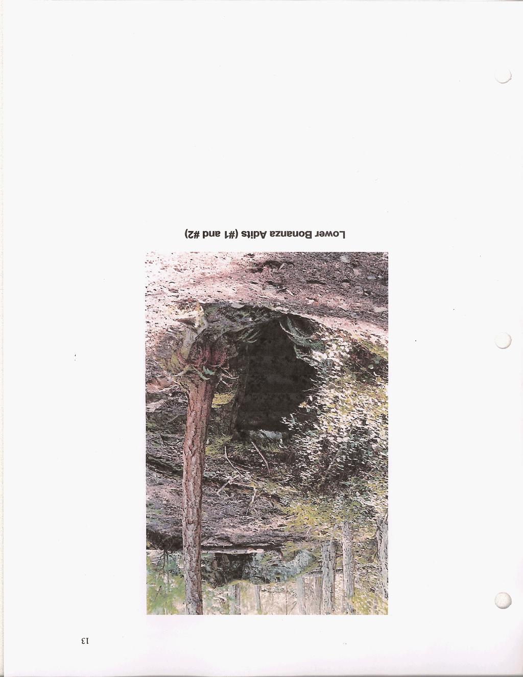
5 ., 3 c Property is underlain by Bowen Island Group rocks, however, the northern boundary of a large intrusion of quartz diorite and diorite follows an indistinct contact zone near the southern boundary of the property. The age of the Bowen Island Group has been assumed through stratigraphic inference to be Jurassic in age, but no diagnostic fossils have been found to date to confirm this / I \ BONANZA MINE PROPERTY MAP 5.0 BONANZA MINE GEOLOGY AND MINERALIZATION r Two lower adits, located just above the main road near the Community of Bluewater at about 150 metres elevation, contain chalcopyrite and pyrrhotite in sheared Bowen Island Group intermediate volcanic rock. The lowermost adit (#I) is approximately 50 metres in length with two short crosscuts, and an adjoining 5 metre long adit (#2) is located just uphill. A small amount of dump
6 4 material and debris has partially blocked the lower adit portal, causing minor flooding in the adit to a depth of about 30 cm. Mineralization in the form of chalcopyrite, pyrrhotite and pyrite is found within a narrow west-northwesttrending shear zone crossing greenish volcanic rocks, best exposed at the #2 adit. Due to the heavily oxidized nature of the exposed rock, strike and dip of the shear zone(s) and thickness of the mineralization is difficult to ascertain. A dump grab sample (2005-B1) from the #2 adit was assayed and found to contain 2.48% copper, 1.51 g/t gold, 80 g/t silver, 650 ppm cobalt, 280 ppm nickel, and 560 ppm zinc. Following the Bluewater Trail from the lower adits up the mountainside, a 5 metre long adit (M) was found near a small stream at about 260 metres elevation. It follows a narrow west-northwest-trending quartz-filled shear zone with disseminated galena, sphalerite, chalcopyrite, pyrite and pyrrhotite. A dump grab sample (2005-B3) was assayed and found to contain 0.339% copper, 1.56 g/t gold, 76 g/t silver, 2.22%lead, 0.174% zinc, and 460 ppm arsenic. Continuing north along the old logging road known as the Mt. Gardner Trail, the main Bonanza Mine adit (#3) is found at an elevation of 360 metres. The #3 tunnel follows a mineralized zone up to 1 metre wide trending west-northwest for about 90 metres. A water-filled shaft of unknown depth is located near the inner end of the adit, and an old ore-car was found on the dump. Similar to the lower adit (#l), a small amount of debris at the portal has caused water to back up in the adit to a depth of about 30 cm. The main Bonanza workings follow a mineralized zone in sheared greenish volcanics and banded cherty tuffaceous sediments. The massive-sulphide zone as seen in a series of old sloughed trenches on surface contains pyrite, pyrrhotite, sphalerite, galena, arsenopyrite and chalcopyrite in a gangue of cherty tuff and minor quartz. Banding of the sulphide minerals parallel to bedding (?) in the host rock is a striking feature, perhaps indicating a volcanogenic origin rather than an epigenetic shear zone or vein system. Three rock samples were taken from the surface trench and assayed in 1988 ( , 8-2, 8-3), and one ( ) in Results indicate a high content of precious and base metals; Sample# Auozlt Aaozlt Cu% Pb% Zn% As% Sb% 1988-B B B glt 165glt ppm
7 5 The Bonanza Mine ore has a high lead content, consequently a galena-rich sample was submitted for the lead-dating database at UBC in the late 1980's. The lead isotopic data plots up to be Lower Cretaceous in age (-100 my), similar to the volcanogenic Britannia Mine, and may have originated at the same time due to regional hydrothermal and intrusive activity. Alternatively, the Bowen Island Group host rocks may be much younger in age than previously thought and the Bonanza deposit could be syngenetic in nature. 6.0 CONCLUSIONS AND RECOMMENDATIONS The Bonanza Mine workings are located in a culturally and environmentally sensitive area, in addition to potentially impacting on the water quality of the Community of Bluewater. The general drainage area naturally contains high amounts of suspended metals due to the geologic occurrences thereof, both known and unknown, and it would seem that this drainage system would be a poor choice of household water supply. However, water supplies are at a premium on Bowen Island due to a major building boom. Any attempted filtration of the Pb and As content would likely be prohibitively costly, so a planned elimination of highly metalliferous streams from the community water system would seem to be the most direct approach. Prospecting and mapping of the property in detail would assist the Community of Bluewater in identfying any such streams. A soil and stream drainage geochemical survey would certainly outline anomalous areas as well. The main Bonanza Mine mineral deposit appears to be relatively rich in assay values, but total volume of mineralized material must be taken into account when judging the economics. Mining or major ground disturbance would almost certainly be met with local opposition, so a different development plan with acceptable goals needs to be addressed. Given the close proximity to a major metropolitan center such as Vancouver, and the unique geological/historicai nature of the mine area, several uses suggest themselves. The mine area could be used as a teaching site, to promote an understanding of historic mining methods and the geology of Bowen Island, similar to the BC Museum of Mining at Britannia Beach. Groups of schoolchildren or tourists could be guided through the lush forest and see spectacular views over Howe Sound, while learning about our natural and mining history and perhaps have the chance to take home a piece of gold ore. In addition, the rustic nature of the lower tunnels and the close proximity to a road suggests potential usage by the BC Film Industry. A recommended work program to facilitate all of these potential outcomes and needs would include detailed prospecting, geological mapping and sampling, followed by a geochemical soil and stream sediment survey. Selective handclearing of brush around the portals and trenches and reestablishment of the adit drainages to prevent in-situ leaching and facilitate access would also greatly
8 6 assist in sampling and mapping. Rock condition of the #I and #3 tunnels, including testing for gasses present, should be ascertained by a professional mining engineer. Any trail maintenance due to windfalls or erosion should also be completed. Where possible, local labour could be used to assist in these tasks. A business plan will be developed to investigate the Geotourism potential of the area, and the BC Film Industry will be advised a new filming location is available. 7.0 REFERENCES Brewer, M Memorandum Report on the Bowen Island Copper Company s Property, Bowen Island, BC LeRoy, O.E GSC Report No. 996 Preliminary Report on a Portion of the Main Coast of British Columbia and Adjacent Islands, page 37 Roddick, J GSC Memoir 335 Vancouver North, Coquitlam, and Pitt Lake Map Areas, British Columbia
9 Statement of Qualifications I, James W. Laird do state that; My address is PO Box 672, Lions Bay, BC VON 2E0 I am a prospector and mining exploration contractor and have been for more than 25 years. I have completed the BC EMPR course Advanced Mineral Exploration for Prospectors, I am the registered and beneficial owner of the Bonanza 1 and 2 mineral claims. I managed and participated in all phases of this exploration program, the opinions and conclusions stated herein are entirely my own. James W. Laird Laird Exploration Ltd July 10, 2005
10 8 Bonanza Gold Propertv. Bowen Island, BC Statement of Expenses 2 W05 Waqes James Laird, Qualified Prospector April 11, 2004 September 13, 2004 March 28, $ per day Brendan Laird, Prospector March 28, $85.00 day $ $85.00 BC Ferries $ x4 Truck Mileage Inclusive 200 $0.60 per krn $ Assays $ Field Supplies $ Report and Drafting $ Total $
11 9 ACME ANALYTICAL LABORATORIES LTD. DATE RECEIVED: SEP E. HASTINGS ST: VANCOUVER B.C. V6A 1R6 PHONE(604) FAX(604) DATE REPORT MAILED:... ASSAYER: e 7. ASSAY CERTIFICATE - SWLK TIPI: Boa AU - 1I 61I RIM ASSAT. D.TOYE OR C. LEONG, CERTIFIED B. C. ASSAYERS JAMES W. LAIRD PROJECT BONANZA FILE # SAMPLE# Cu Pb Zn Ag Au As Sb % % Sg OZ/T OZ/T % % a B , a8 B
12 1 4' A To: LAlRD EXPLORATION LTD. PO BOX 672 UONS BAY BC MN 2EO ProJed: FAST P.O. No.: Th& report Is for 6 Rock sampkt rubm#ted to our lab in Vancouver, BC, Canada on 23-JUN The following have access to data 8ssociated with this certificate: JAMESUlRO 1 I ALS CODE Wtl-21 LOQ-22 C W 1 8pl-21 PUL-31 AL6coDE DESCRIPTION Reodwd Sample Wd#tt ~Iogh-RCd~BalCode Fhe uuehing - 70% Qmm 6pllt mmpb - rmo splhter Puhnri~~ rpllt to 86% <76 ~m ANALYTICAL PROCEDURES DEscRlQTKm INSTRUMENT cu-am2 Om grade Cu - buradd / AS AA8 i3aa62 on gmcbzn four acid /AAs AA8 MEORA21 Au Ag 309 FAQRAV filnleh WST-SIM ME-ICPOla High Qnde Four Add ICP-AES ICP-AE8 To: WRD EXPLORATION LTD. AI" JAMES WRD Po Box 672 LIONS BAY BC WN ZEO Thk k the Flnd RbpoR and r u w any prdlmlnvy report with this certificaie number. Reeutts appty to samples a8 eubrnlttod. AU pagw dthlo report have ken checked end apprwed for release. Signature: -+
13 1 TO: WRD EXPLORATION LTD. PO BOX 672 WNS BAY BC M N PEO Pmz2-A FInalW Total Dato: I Pages: WUN (A - 6) Account: WMP Project: COAST
14 I. *. A ALS Chomex To: WRD EXPLORATION LTC). PO BOX $72 UON8 BAY BC VON 2EO I CERTIFICATE OF ANALYSIS VAOW8848 w <lo lmm m % a <o.m w 1.5 do s rn m ia2o
15 ... I,.

16 Bonanza Mine #3 Adit
17 Bonanza #4 Adit
The Cobalt Rainbow. Airborne geophysical maps show that a north trending aeromagnetic high suggests further undiscovered mineralisation.
 The Cobalt Rainbow The property is located on Greenstone Creek, approximately 4.8 kilometres south west of the creek mouth. The property is located about 24 km due west of Campbell River, in the east-central
The MAPLE BAY PROJECT Copper Silver - Gold
 The MAPLE BAY PROJECT Copper Silver - Gold Good grade and tonnage potential within close proximity to Tidewater The Maple Bay Copper Silver Gold Project covers highly favourable geological host rocks of
2013 GEOLOGICAL ASSESSMENT REPORT SHERIDAN HILL PROPERTY
 2013 GEOLOGICAL ASSESSMENT REPORT ON THE SHERIDAN HILL PROPERTY NEW WESTMINSTER MINING DIVISION BRITISH COLUMBIA NTS 092G07 49 16 31 NORTH LATITUDE, 122 39 48 WEST LONGITUDE PREPARED FOR Sheridan Hill
12 tons of high-grade ore was mined from the No. 1 vein with an average grade of 13 g/t gold, 3,250 g/t silver and 23.3% lead.
 DUNWELL MINE GROUP The Dunwell Mine Group (Dunwell, Dunwell East, Bear River/MM and Silvershot properties), which includes the historic, past-producing Dunwell mine, is located 8 km northeast of Stewart
PROSPECTORS ASSISTANCE PROGRAM MINISTRY OF ENERGY AND MINES
 BRITISH COLUMBIA PROSPECTORS ASSISTANCE PROGRAM MINISTRY OF ENERGY AND MINES GEOLOGICAL SURVEY BRANCH PROGRAM YEAR: 1999/2000 REPORT #: PAP 99-l 6 NAME: KIM ANSCHETZ PROSPECTORS TlEPORT on the 99 LOUIS
NEW HAZELTON, OMINECA M.D.,
 PROSPECTING REPORT JUDI 1 TO 6 MINERAL CLAIMS NEW HAZELTON, OMINECA M.D., B.C. MAP 93M/4E, LAT. SS014'N, LONG. 127'33'W OWNED BY: A. L'ORSA ANTHONY L'ORSA Smithers, B.C. 21 February, 1981 TABLE OF CONTENTS
1 FILMED 1. FILE NO:!..rsrru -* -. GRAND TWO CLAIM
 FILE NO:!..rsrru -* -. GRAND TWO CLAIM REPORT ON 1993 ASSESSMENT WORK GRAND TWO CLAIM REC. NO. 301849 NELSON MINING DIVISION NTS MAP SHEET 82F6/W 49 25'51" NORTH 117 18'08" WEST 1 FILMED 1 AUTHOR: R. Jordan,
VANCOUVER, B.C. Tri 082F/ F/059
 GEOCHEMCAL REPORT t MAY L, 2006 Whbpper Mineral Claims Ailsa Lake Area Gold comm~ss16fl8f"s Offim on Mining Division VANCOUVER, B.C. Tri 082F/058 082F/059 3792 E 5486438 N Operator Kootenay Gold nc. Suite
A New Direction. Copper-Gold Deposit at Thor TSX.V:COL. August 11, May 2013
 A New Direction Copper-Gold Deposit at Thor August 11, 2016 May 2013 TSX.V:COL FORWARD LOOKING STATEMENTS This presentation includes certain forward-looking information or forward-looking statements for
HOWE COPPER MINE PROJECT HIGH GRADE Cu-Ag with Au
 HOWE COPPER MINE PROJECT HIGH GRADE Cu-Ag with Au The Howe Copper Mine property is located approximately 55 kilometres northwest of Vancouver, BC. It is situated at 1431 metres elevation on the eastern
Prospecting Report 'S Office i DB Property, B.C. -J Negro Creek Nelson Mining District NTS 82F.050. Operator: Kootenay Gold Inc.
 . '.' I"' i9 12 Prospecting Report 'S Office i DB Property, B.C. -J Negro Creek Nelson Mining District NTS 82F.050 Operator: Kootenay Gold Inc. Owner: Darlene Lavoie Work Performed Summer of 2007 Report
Location/Identification
 MINFILE Detail Report BC Geological Survey Ministry of Energy, Mines and Natural Gas and Responsible for Housing Location/Identification MINFILE Number: 092L 178 National Mineral Inventory Number: 092L14
Lat. 52' 43' N Long ' W
 &A exploration ltd MINING ENGINEERING GEOLOGY- GEOPHYSICS 4570 HOSKINS ROAD, NORTH VANCOUVER, 6. C. TELEPHONE (804) 985,7921 V7K 2R1 GEOLOGICAL AND GEOCHEMICAL REPORT on the BLUE CLAIMS Cariboo Mining
DSM SYNDICATE DISCOVERS POLYMETALLIC MINERALIZATION WITH TALUS GRAB SAMPLES CONTAINING UP TO PERCENT LEAD AND 18
 DSM SYNDICATE DISCOVERS POLYMETALLIC MINERALIZATION WITH TALUS GRAB SAMPLES CONTAINING UP TO 92.8 GRAMS PER TONNE GOLD, 13,643 GRAMS PER TONNE SILVER, 13.85 PERCENT LEAD AND 18.65 PERCENT COPPER FROM DIFFERENT
ASSESSMENT REPORT ON THE PEAVINE PROJECT. DGW & Associates # Alberni Street, Vancouver, British Columbia, V6E 4V2
 ASSESSMENT REPORT ON THE PEAVINE PROJECT KAMLOOPS MINING DIVISION BRITISH COLUMBIA NTS 082M 12 Latitude 51 36' 19.0"North -- Longitude --119 47' 27.0"West UTM Zone 11, NAD 83 5720827N 306744E Prepared
for the Greenwood Mining Division, B.C. NTS 82E/7W Latitude 49' 27' W, Longitude 118' 5 Prepared by a= D. Dylan Watt, B.Sc.
 t. b LOGnO: 37~ -08 m. ACTIO#: for the AMP AMP 2 AMP 3 t AMP 4 CLAIMS Greenwood Mining Division, B.C. NTS 82E/7W Latitude 49' 27' W, Longitude 8' 5 %E c,w zc *& a w Prepared by a= -4c. D. Dylan Watt, B.Sc.
RECONNAISSANCE GEOCHEMICAL SURVEY
 RECONNAISSANCE GEOCHEMICAL SURVEY LEGAL, RITA, LOUISE FR. (CHAPLEAU GROUP) REVERTED CROWN GRANTS CHAPLEAU CREEK AREAJ, SLOC& MINING DIVISION 82 F/11W Lat: 49'44" Long: 117"22'W MINERAL RESOURCES BRANCH
Bass Metals records further positive drill results & progress at 3 prospects.
 16 March 2011 Bass Metals records further positive drill results & progress at 3 prospects. HIGHLIGHTS: New high-grade drilling intercept confirms Switchback potential; Drilling commences at Lake Margaret
ASX Announcement. 28 January Drill results indicate large Porphyry Copper Gold System at Peenam
 ASX Announcement 28 January 2010 Drill results indicate large Porphyry Copper Gold System at Peenam Highlights: 270 metres of visible copper (gold) mineralisation in first diamond core hole at Peenam Prospect
LUCKY BEN MINE PROJECT SEPTEMBER 2018 UPDATE
 LUCKY BEN MINE PROJECT SEPTEMBER 2018 UPDATE During the first week of July 2018 work was completed by our Geologist, Richard Morris, and support personnel to stake the Lucky Ben vein structure at surface
COMBINATION OF MMI AND ENZYME LEACH METHODS IN EXPLORATION FOR GOLD IN AN AREA OF THE CANADIAN SHIELD COVERED WITH GLACIAL SEDIMENTS: A CASE STUDY
 COMBINATION OF MMI AND ENZYME LEACH METHODS IN EXPLORATION FOR GOLD IN AN AREA OF THE CANADIAN SHIELD COVERED WITH GLACIAL SEDIMENTS: A CASE STUDY Nadia Yavorskaya 450 Bonner Ave., Winnipeg, MB, Canada
ASSESSMENT REPORT PROSPECTING PROGRAM ION/DIRTY JACK PROPERTY NELSON MINING DIVISION N.T.S. MAP SHEET 82F.023 UTM COORDINATES N E
 ASSESSMENT REPORT PROSPECTING PROGRAM ION/DIRTY JACK PROPERTY NELSON MINING DIVISION N.T.S. MAP SHEET 82F.023 UTM COORDINATES 5454800N - 0455235E Work Performed Summer 2007 OWNER >* ' Tom Kennedy >8 404-22
Copper and Zinc Production, Disciplined Growth. S I T E V I S I T O C T O B E R % Owned Projects
 Copper and Zinc Production, Disciplined Growth. S I T E V I S I T O C T O B E R 2 0 1 6 100% Owned Projects Serbia assets Timok Magmatic Complex Rakita Joint Venture 4 exploration permits in the Bor region,
MINCOR /GOLDEN RIM FIJI JOINT VENTURE SIGNIFICANT NEW EXPLORATION RESULTS
 1 November 2007 MINCOR /GOLDEN RIM FIJI JOINT VENTURE SIGNIFICANT NEW EXPLORATION RESULTS Highlights Very high gold-in-soil sample results up to 17.3 g/t gold have been received from the Banana Creek Prospect.
Geology 12 FINAL EXAM PREP. Possible Written Response Exam Questions
 Geology 12 FINAL EXAM PREP Possible Written Response Exam Questions Use this study guide to prepare for the written response portion of the final exam. Name FINAL EXAM - POSSIBLE WRITTEN RESPONSE QUESTIONS
GEOLOGICAL MAPPING REPORT ON THE ASH MINERAL CLAIM OSOYOOS MINING DIVISION ASHNOLA RIVER MAP SHEET NTS M092,H019 MCBRIDE CREEK AREA, ASHNOLA RIVER,
 GEOLOGICAL MAPPING REPORT ON THE ASH MINERAL CLAIM OSOYOOS MINING DIVISION ASHNOLA RIVER MAP SHEET NTS M092,H019 LATITUDE 49 o O6, LONGITUDE 120 o 22 MCBRIDE CREEK AREA, ASHNOLA RIVER, KEREMEOS, B.C. CANADA
ASX / MEDIA RELEASE 6 MAY MILE SILVER-LEAD-ZINC DISCOVERY; HIGH GRADE SILVER-GOLD IN ROCK CHIPS AT RUBY SILVER
 ASX / MEDIA RELEASE 6 MAY 2011 4-MILE SILVER-LEAD-ZINC DISCOVERY; HIGH GRADE SILVER-GOLD IN ROCK CHIPS AT RUBY SILVER Highlights: Silver-lead-zinc discovery at 4-Mile; mineralisation intersected in all
Serengeti Resources Inc GEOCHEMICAL REPORT ON THE SHADOW PROPERTY a.
 Serengeti Resources Inc. 2004 GEOCHEMICAL REPORT ON THE SHADOW PROPERTY a. Located in the Johanson Lake Area Omenica Mining Division NTS 94D/9 6 degrees and 32 minutes North Latitude 126 degrees and 2
NTS 082F03SW N W U E N
 Prospecting Report JOCELYN CLAIM NTS 082F03SW N49 09 51 W 117 14 04 11U 482906E 5445737N NELSON MINING DIVISION Martin Ross PO Box 323 Salmo BC V0G 1Z0 Jan 31, 2012 PROSPECTING REPORT JOCELYN MINERAL CLAIM
A PRELIMINARY REPORT ON THE ZYMOST2 CLAIM GROtP, TERRACE, B.C.
 NATIVE EXPLORATIONS LTD. A PRELIMINARY REPORT ON THE ZYMOST2 CLAIM GROtP, TERRACE, B.C. INTRODUCTION': The Zymoetz claim group is, at present, held under option by Native Explorations Ltd.. On the 19th
For personal use only
 22 April 2013 Drilling to commence at Majada, Copper-Gold Prospect, Chile. Red Gum Resources Limited (ASX: RGX, Red Gum or the Company ) is pleased to announce that drilling of its Majada Copper-Gold Prospect,
News Release No GOLD AND COPPER MINERALIZATION DISCOVERED DURING PHASE 2 EXPLORATION AT THE MCBRIDE PROPERTY
 November 19, 2018 TSX Venture Exchange Listed Frankfurt Exchange Listed News Release No. 303-2018 GOLD AND COPPER MINERALIZATION DISCOVERED DURING PHASE 2 EXPLORATION AT THE MCBRIDE PROPERTY Vancouver,
UNION MINIERE EXPLORATIONS AND MINING CORPORATION LIMITED ASSESSMENT REPORT ON FITINAT MINERAL CLAIM. Alberni Mining Division Record No.
 M F )( UNION MINIERE EXPLORATIONS AND MINING CORPORATION LIMITED Suite 200, 4299 Canada Way, Burnaby, B.C. V5G 1 H4 Telephone (604) 437-9491 ASSESSMENT REPORT ON GEOCHEMICAL SOIL SURVEYS AND ROCKSAMPLING
PROSPECTING REPORT THE WALLACE CLAIM OMENICA MINING DIVISION. 54" x6" 3.d d. for. Reako Exlorat ions Ltd. Wallace Rev. C.G.
 PROSPECTING REPORT ON THE WALLACE CLAIM OMENICA MINING DIVISION 54"44 14 1x6" 3.d d by David A. Howard P.Eng. for Reako Exlorat ions Ltd. Claim Locat ion Wallace Rev. C.G. #1560 Dome Mountain Area 9 3
EXPLORATION LICENCE SURROUNDING THE HISTORIC FALUN COPPER MINE GRANTED
 ASX ANNOUNCEMENT 30 August 2007 EXPLORATION LICENCE SURROUNDING THE HISTORIC FALUN COPPER MINE GRANTED The Drake-Zinifex Alliance application for an exploration licence that covers the historic Falun copper
CONTENTS. Location, Access and History...6. Tenure Status and Geology Regional Andy Property Geology Map...9
 TYPE OFWORK IN THIS REPORT EXTENT OF WORK (rn METRTC UNITS) ON WHICH CLAIMS PROJECT COSTS APPORTIONED (incl. support) GEOLOGICAL (scale, area) Ground, mapping Photo interpretation GEOPHYSICAL (line-kilometres)
CSA Mine Observations Applied to the Development of Regional Exploration Models
 CSA Mine Observations Applied to the Development of Regional Exploration Models 1 Introduction Recent work completed by the geology team has resulted in an improved understanding of the CSA mine system
FIRST YEAR ASSESSMENT REPORT PROSPECTING LICENCE 16512M MARYSTOWN AREA, BURIN PENINSULA NTS 1M/3
 FIRST YEAR ASSESSMENT REPORT OF PROSPECTING ON LICENCE 16512M MARYSTOWN AREA, BURIN PENINSULA NTS 1M/3 BY NATHANIEL NOEL MSc. FOR E. MICHELE NOEL MINERAL LICENCES: 16512 M WORK CONDUCTED: MID-SEPTEMBER
Reconnaissance. Of the. Denis mineral claims. Situated at Kilometer 844 of the Alaska Highway. Liard Mining Division. Northeastern British Columbia
 Reconnaissance Of the Denis mineral claims Situated at Kilometer 844 of the Alaska Highway Liard Mining Division Northeastern British Columbia N.T.S. 94M.075 Latitude 59 42 25 Longitude 127 13 12 Field
DISCOVERY OF MINERALISED PORPHYRY & MAGNETITE-COPPER-GOLD AT KAMARANGAN
 MEDUSA MINING LIMITED ABN: 60 099 377 849 Unit 7, 11 Preston Street Como WA 6152 PO Box 860 Canning Bridge WA 6153 Telephone: +618-9367 0601 Facsimile: +618-9367 0602 Email: admin@medusamining.com.au Internet:
ENCOURAGING GOLD-BASE METALS AT MAY DAY, MOLY- GOLD AT ATTUNGA
 ASX / MEDIA RELEASE 5 JULY 2010 ENCOURAGING GOLD-BASE METALS AT MAY DAY, MOLY- GOLD AT ATTUNGA Peel Exploration is pleased to announce that recent drilling at the Company s Attunga and May Day projects
Sotkamo Silver Mo i Rana and Tampere areas. Erkki Kuronen Chief Geologist, M.Sc., MAusIMM Sotkamo Silver Oy
 Mo i Rana and Tampere areas Erkki Kuronen Chief Geologist, M.Sc., MAusIMM Oy Mo i Rana and Tampere areas Erkki Kuronen Chief Geologist, M.Sc., MAusIMM Oy 2.9.2018 Silver 2 Deposits and Projects develops
Drilling Program Commences on Iron Oxide Copper Gold Targets
 3 June 2008 Manager Company Announcements Company Announcements Office Australian Stock Exchange Limited Level 10, 20 Bond Street SYDNEY NSW 2000 ABN 42 082 593 235 Electronic delivery No of pages: 6 Drilling
Tameapa Regional Geology
 Tameapa Project 1 Tameapa Regional Geology History San Francisco Mines of Mexico Ltd. (San Francisco), which completed an exploration program, including six drill holes (1,157 m) between 1956 and 1959.
MORE HIGH-GRADE GOLD INTERSECTIONS FROM CITADEL S SHAYBAN PROJECT, SAUDI ARABIA
 Citadel Resource Group Limited ASX Release 7th July 2009 MORE HIGH-GRADE GOLD INTERSECTIONS FROM CITADEL S SHAYBAN PROJECT, SAUDI ARABIA Highlights: LATEST RC IN-FILL AND EXTENSIONAL DRILLING CONTINUES
NEW COBAR-STYLE COPPER DISCOVERY IN NSW
 ASX / MEDIA RELEASE 2 AUGUST 2011 NEW COBAR-STYLE COPPER DISCOVERY IN NSW Broad zone of copper-polymetallic mineralisation intersected at 4-Mile prospect Highlights: Wide zone of copper-silver-gold-lead-zinc
BLURTON CREEK NICKEL PROPERTY. (Minfile # 082LNW-039)
") 5489153 BLURTON CREEK NICKEL PROPERTY (Minfile # 082LNW-039) Mara Lake Area / Salmon Arm B.C NTS - 82L-11 (UTM 83/Z10, 357690E, 5614220N) Prepared by: Jim Cuttle, B.Sc., P.Geo. 86 Cloudburst Road Whistler,
5489153 BLURTON CREEK NICKEL PROPERTY (Minfile # 082LNW-039) Mara Lake Area / Salmon Arm B.C NTS - 82L-11 (UTM 83/Z10, 357690E, 5614220N) Prepared by: Jim Cuttle, B.Sc., P.Geo. 86 Cloudburst Road Whistler,
SECOND and THIRD YEAR ASSESSMENT REPORT PROSPECTING LICENCE M, ROCK CUT PROPERTY, NTS 1N/12, NEWFOUNDLAND. ROY FRENCH (licence holder )
") SECOND and THIRD YEAR ASSESSMENT REPORT Of PROSPECTING On LICENCE 013704M, ROCK CUT PROPERTY, NTS 1N/12, NEWFOUNDLAND. By ROY FRENCH (licence holder ) Work Conducted: Sept. 17, 2008 Nov. 03, 2009 Total
SECOND and THIRD YEAR ASSESSMENT REPORT Of PROSPECTING On LICENCE 013704M, ROCK CUT PROPERTY, NTS 1N/12, NEWFOUNDLAND. By ROY FRENCH (licence holder ) Work Conducted: Sept. 17, 2008 Nov. 03, 2009 Total
NEWS RELEASE CANADIAN ZINC REPORTS REMAINING DRILL RESULTS AT LEMARCHANT DEPOSIT, SOUTH TALLY POND PROJECT, NEWFOUNDLAND
 NEWS RELEASE CZN-TSX CZICF-OTCQB FOR IMMEDIATE RELEASE March 5, 2018 CANADIAN ZINC REPORTS REMAINING DRILL RESULTS AT LEMARCHANT DEPOSIT, SOUTH TALLY POND PROJECT, NEWFOUNDLAND 2017 drill program successfully
Verification Rock Geochemical Survey on the Casino Property
 Verification Rock Geochemical Survey on the Casino Property Trail Creek Mining Division British Columbia NTS 082F04 Latitude 49 04 40.3 North Longitude 117 39 1.4 West UTM Zone 11, NAD 83 5436320N 452500E
GOLIATH REPORTS g/t Au and 1845 g/t Ag (53.9 oz/t) FROM 1 METRE CHIP SAMPLE AT DSM SKYHIGH PROPERTY
 FROM 1 METRE CHIP SAMPLE AT DSM SKYHIGH PROPERTY") GOLIATH REPORTS 15.75 g/t Au and 1845 g/t Ag (53.9 oz/t) FROM 1 METRE CHIP SAMPLE AT DSM SKYHIGH PROPERTY Toronto, Ontario December 4 th, 2018 Goliath Resources Limited (TSX-V: GOT) (OTCQB: GOTRF) (FSE:
GOLIATH REPORTS 15.75 g/t Au and 1845 g/t Ag (53.9 oz/t) FROM 1 METRE CHIP SAMPLE AT DSM SKYHIGH PROPERTY Toronto, Ontario December 4 th, 2018 Goliath Resources Limited (TSX-V: GOT) (OTCQB: GOTRF) (FSE:
49" 3-4 I4 I \ Y 59 tj
 ASSESSMENT REPORT Mary 4 FORT STEELE M.D. NTS 82G/5W 49" 3-4 4 \ Y 59 tj Owner: St. Eugene Mining Corporation Limited Operator : St. Eugene Mining Corporation Limited Author: John R. Wilson Date Submitted:
Pacific Empire Minerals Provides Copper King RC Drilling Results
 Pacific Empire Minerals Provides Copper King RC Drilling Results November 1, 2018 - Vancouver, BC, Canada - Pacific Empire Minerals Corp. (TSXV: PEMC) ( Pacific Empire, PEMC or the Company ), a hybrid
Gungnir Resources Inc.
 Gungnir Confirms Near-Surface Gold Mineralization and Drills New Copper- Nickel Bearing Sulphides at Knaften in Sweden Vancouver October 23, 2017 - Gungnir Resources Inc. (GUG: TSX-V, ) ( Gungnir or the
American Creek Resources is a precious metals exploration company with an impressive portfolio of high-potential gold
 American Creek Resources is a precious metals exploration company with an impressive portfolio of high-potential gold and silver projects in British Columbia. These include properties in B.C.'s prolific
Burchell Lake, A Copper, Gold and Molybdenum Property In Ontario. Corporate Presentation September, 2013
 Burchell Lake, A Copper, Gold and Molybdenum Property In Ontario Corporate Presentation September, 2013 Background Tanager Energy Inc. is a Canadian corporation whose shares are traded on the TSX Venture
NEWS RELEASE. Evrim announces additional drilling results at Cuale Gold Project in Mexico
 910-850 WEST HASTINGS ST. VANCOUVER, BC, CANADA V6C 1E1 TEL: 604.248.8648 FAX: 604.248.8663 WWW.EVRIMRESOURCES.COM TSX-V: EVM CONTACT: PADDY NICOL OR CHARLES FUNK NEWS RELEASE Evrim announces additional
for the Greenwood Mining Division, B.C. NTS 82E/7W 29' W, Longitude 118' 53' N Prepared by D. Dylan Watt, B.Sc.
 for the FltE NO: u VOLT 1, VOLT 2, VOLT 3, & VOLT 4 CLAIMS Greenwood Mining Division, B.C. NTS 82E/7W Latitude 49' 29' W, Longitude 118' 53' N Prepared by D. Dylan Watt, B.Sc. #309-1996 Trutch Street Vancouver,
Goliath Reports Grams Per Tonne Gold Equivalent Over 2 Metres Channel Cut at Golddigger in the Golden Triangle; Bulk Sample Recommended
 Goliath Reports 22.83 Grams Per Tonne Gold Equivalent Over 2 Metres Channel Cut at Golddigger in the Golden Triangle; Bulk Sample Recommended November 28, 2017 Goliath Resources Ltd. (TSX-V: GOT) (the
Daiwan Engineering Ltd Granville strees V.ncouver, B. C. cuudr WY 1GS. M e : (604) PROSPECTING REPORT ON THE KING MINERAL CLAIMS
 PROSPECTING REPORT ON THE KING MINERAL CLAIMS") 1030-609 Granville strees V.ncouver, B. C. cuudr WY 1GS M e : (604) 688-1508 PROSPECTING REPORT ON THE KING MINERAL CLAIMS NORTH VANCOUVER ISLAND, BRITISH COLUMBIA NTS: 92Lj13E Latitude: 50" 47' Longitude:
1030-609 Granville strees V.ncouver, B. C. cuudr WY 1GS M e : (604) 688-1508 PROSPECTING REPORT ON THE KING MINERAL CLAIMS NORTH VANCOUVER ISLAND, BRITISH COLUMBIA NTS: 92Lj13E Latitude: 50" 47' Longitude:
PROSPECTING REPORT. Medallion Property. EVENT # TENURE # Tenure Name: GPEX CLVIII Medallion
 2006-2007 PROSPECTING REPORT Medallion Property EVENT # 4167980 TENURE # 540362 Tenure Name: GPEX CLVIII Medallion Watson Bar Region Clinton Mining Division Map 092O Central Coordinate Reference Long.
The Cerattepe Massive Sulphide Property, Northeastern Turkey
 Integrated Exploration Case Histories Paper 139 Explor97 Master Page Explor97 Contents Previous Paper G O T O Author Index Section Contents The Cerattepe Massive Sulphide Property, Northeastern Turkey
Drilling Extending Mineralization in La Mina North Zone
 Toachi Mining Inc. Intersects 5.42 m grading 4.35 g/t Au, 77.34 g/t Ag, 7.48% Cu, 4.24% Zn and 0.22% Pb at the Gold-Rich La Plata VMS Project in Ecuador Drilling Extending Mineralization in La Mina North
Summary of Rover Metals Geologic Mapping Program at the Up Town Gold Project, Northwest Territories
 October 13, 2017 Summary of Rover Metals Geologic Mapping Program at the Up Town Gold Project, Northwest Territories Vancouver, British Columbia, Canada - Rover Metals Corp., Rover, is pleased to provide
COPPERSTONE RESOURCES AB INTERCEPTS ZONE OF CHALCOPYRITE-ARSENOPYRITE- BORNITE MINERALIZATION AT SVARTLIDEN IN FIRST DEEP DRILLHOLE FROM 720m-810m
 COPPERSTONE RESOURCES AB INTERCEPTS ZONE OF CHALCOPYRITE-ARSENOPYRITE- BORNITE MINERALIZATION AT SVARTLIDEN IN FIRST DEEP DRILLHOLE FROM 720m-810m In mid-january 2017 Copperstone Resource published a geological
PRECIOUS METALS. owner. JMT Services Corp. GEOCHPlICAL SAMPLING CHELASLIE WCE, NORTH CENTRAL, B.C. OMINECA MINING DIVISION NTS 93F/5E & 6W
 PRECIOUS METALS REPORT ON 1980 RECONNAISSANCE GEOCHPlICAL SAMPLING CHELASLIE WCE, NORTH CENTRAL, B.C. OMINECA MINING DIVISION NTS 93F/5E & 6W LATITUDE 53O28 N LONGITUDE 125O31 W DATES Qp WORK: JULY 10
MEXICAN GOLD SAMPLES 5.11 G/T GOLD & 7.15 % ZINC OVER 2.0 METRES AND G/T GOLD OVER 1.4 METRES AT CHANGARRO ZONE, LAS MINAS PROJECT
 Thunder Bay, Ont. TSX-V: MEX For Immediate Release July 24, 2018 MEXICAN GOLD SAMPLES 5.11 G/T GOLD & 7.15 % ZINC OVER 2.0 METRES AND 11.14 G/T GOLD OVER 1.4 METRES AT CHANGARRO ZONE, LAS MINAS PROJECT
AiG ON THE EASTRIM mm. Record number KENNJZDY LAKE AREA - ALBERNI MINING DIVISION Map 92Fl3 W
 ON THE EASTRIM mm CLAIM Record number 3799 19 KENNJZDY LAKE AREA - ALBERNI MINING DIVISION Map 92Fl3 W 125" 23' West Lbngitude - 49" 09' North Latitude Walter GUPPY August ZO;i;! t I : AiG272002 TABLE
GEOPHYSICAL ASSESSMENT REPORT (TOP & BOTTOM CLAIMS) MCINTYRE LAKE. VERNON MINING DIVISION, B-Cm
 MCINTYRE LAKE. VERNON MINING DIVISION, B-Cm") GEOPHYSICAL ASSESSMENT REPORT on the TOP PROPERTY (TOP & BOTTOM CLAIMS) MCINTYRE LAKE VERNON MINING DIVISION, B-Cm NTS : Latitude: 50'04' North Longitude: Owner: Consultant : Author : 118'33 ' West Brican
GEOPHYSICAL ASSESSMENT REPORT on the TOP PROPERTY (TOP & BOTTOM CLAIMS) MCINTYRE LAKE VERNON MINING DIVISION, B-Cm NTS : Latitude: 50'04' North Longitude: Owner: Consultant : Author : 118'33 ' West Brican
EXPLORING NEW GOLD FRONTIERS IN CANADA
 WWW. A LTOV E N T U R E S. C O M EXPLORING NEW GOLD FRONTIERS IN CANADA MARCH 2018 FORWARD LOOKING STATEMENT 2 Certain statements contained in this presentation may contain forward-looking information
Amador Canyon Silver Mining Property Lander County, NV
 Amador Canyon Silver Mining Property Lander County, NV Over $1 million worth of exploration and evaluation work performed Favorable drill results including a return of 286 g/ton silver over 12.2 meters
Compilation Report Hawke Hill South. Licence No M NTS 01N/06. Newfoundland and Labrador. Submitted by Gordon E. Cooper and Kevin P.
 Compilation Report 2010 Hawke Hill South Licence No. 017282M NTS 01N/06 Newfoundland and Labrador Submitted by Gordon E. Cooper and Kevin P. Ryan For Kevin P. Ryan (Licence holder) January, 2011 Work Year:
For personal use only
 ANNOUNCEMENT TO THE AUSTRALIAN SECURITIES EXCHANGE: 28 NOVEMBER 2012 DRILLING UPDATE MABILO PROJECT The Directors of Sierra Mining Limited ( Sierra ) are pleased to announce further results from reconnaissance
The Gold Hill s Big Chief Showing. Cross Section Line A-A' (Pighin 2014)
") GOLD HILL SUMMARY In 1864 gold fever struck in the south Kootenays east of Cranbrook, British Columbia as placer gold was discovered in the Wild Horse River. What followed was everything one can imagine
GOLD HILL SUMMARY In 1864 gold fever struck in the south Kootenays east of Cranbrook, British Columbia as placer gold was discovered in the Wild Horse River. What followed was everything one can imagine
ASSESSMENT REPORT MAGNETOMETER SURVEY GOLDEN ROD, GOLDEN ROD #2. Long.: General Delivery, Vananda, B. C.
 ASSESSMENT REPORT MAGNETOMETER SURVEY GOLDEN ROD, GOLDEN ROD #2 t=/ NTS 92~110w Lat.: Long.: 49O 44' N 124O 34' W Owner: E. Johanson General Delivery, Vananda, B. C. Operator: Rhyolite Resources I nc.
For personal use only
 ASX RELEASE 13 July 2012 ASX Code: PMQ Encouraging Field Exploration Results: Mount Borium Gold Project Key Points Third phase of field exploration underway the Company has been highly active since the
FIRST 2 DRILL HOLES AT NAKRU-2 PROSPECT BOTH INTERSECT SIGNIFICANT HIGHER GRADE COPPER MINERALISATION
 ADDRESS PHONE PO Box 6965 +61(07) 5592 1001 Gold Coast Mail Centre FAX Qld 9726 Australia +61 (07) 5592 1011 EMAIL ABN 54 126 490 855 info@coppermoly.com.au WEBSITE www.coppermoly.com.au ASX Announcement
Drilling program commences on Cloncurry and Mount Isa projects
 1P P May UASX/Media Announcement st 2009 Drilling program commences on Cloncurry and Mount Isa projects Key Points 1,700 metres reverse circulation drilling program over two prospects on untested geochemical,
NEWS RELEASE. Evrim and Harvest Gold Complete Drilling at Cerro Cascaron
 910-850 WEST HASTINGS ST. VANCOUVER, BC, CANADA V6C 1E1 TEL: 604.248.8648 FAX: 604.248.8663 WWW.EVRIMRESOURCES.COM TSX-V: EVM CONTACT: PADDY NICOL OR CHARLES FUNK NEWS RELEASE Evrim and Harvest Gold Complete
VECTORING VOLCANOGENIC MASSIVE SULPHIDE MINERALIZATION AT THE RAINDROP ZONE, SNOW LAKE (NTS 63K16), MANITOBA by G.H. Gale
, MANITOBA by G.H. Gale") GS-8 VECTORING VOLCANOGENIC MASSIVE SULPHIDE MINERALIZATION AT THE RAINDROP ZONE, SNOW LAKE (NTS 63K16), MANITOBA by G.H. Gale Gale, G.H. 2002: Vectoring volcanogenic massive sulphide mineralization at
GS-8 VECTORING VOLCANOGENIC MASSIVE SULPHIDE MINERALIZATION AT THE RAINDROP ZONE, SNOW LAKE (NTS 63K16), MANITOBA by G.H. Gale Gale, G.H. 2002: Vectoring volcanogenic massive sulphide mineralization at
For personal use only
 ASX/MEDIA ANNOUNCEMENT 16 NOVEMBER 2012 ASX Code: HOR Management Mr Jeremy Shervington Non Executive Chairman Mr Neil Marston Managing Director Mr Michael Fotios Non Executive Director Mr Stuart Hall Non
Hole (93) From (m) To (m) m Au (g/t) Ag (g/t) Cu (%) Pb (%) Zn (%) CMLP
 From (m) To (m) m Au (g/t) Ag (g/t) Cu (%) Pb (%) Zn (%) CMLP") Toachi Mining Inc. Intersects 13.91 m grading 3.51 g/t Au, 64.24 g/t Ag, 0.59% Cu, 4.11% Zn and 0.85% Pb at the Gold-Rich La Plata VMS Project in Ecuador Toronto, Ontario October 11, 2017 Toachi Mining
Toachi Mining Inc. Intersects 13.91 m grading 3.51 g/t Au, 64.24 g/t Ag, 0.59% Cu, 4.11% Zn and 0.85% Pb at the Gold-Rich La Plata VMS Project in Ecuador Toronto, Ontario October 11, 2017 Toachi Mining
For personal use only
 25 January 2017 HIGH GRADE ZINC, LEAD AND SILVER RESULTS UPDATE Korab Resources Ltd ( Korab, or Company ) () refers to the ASX report dated 23 November 2016 which discussed the review of historical RC
Drilling Extending Mineralization in La Mina North Zone
 Toachi Mining Inc. Intersects 10.78 m grading 6.35 g/t Au, 54.32 g/t Ag, 9.64% Cu, 8.70% Zn and 0.43% Pb at the Gold-Rich La Plata VMS Project in Ecuador Drilling Extending Mineralization in La Mina North
NEWS RELEASE Ocean Park Ventures Identifies Large Multi-Structure Sulfide Mineralized System Trapper Gold Project, British Columbia
 Suite 302 750 West Pender St Vancouver, BC V6C 2T7 Tel: 604-681-0084 Fax: 604-681-0094 www.oceanparkventures.com TSX-V SYMBOL: OCP NEWS RELEASE Ocean Park Ventures Identifies Large Multi-Structure Sulfide
GEOLOGY OF THE NICOLA GROUP BETWEEN MISSEZULA LAKE AND ALLISON LAKE
 GEOLOGY OF THE NICOLA GROUP BETWEEN MISSEZULA LAKE AND ALLISON LAKE (92H/15E. 10E1 By V. A. Preto INTRODUCTION Mapping was continued southward from the area covered in 1973 and an additional 55 square
For personal use only
 HIGHLIGHTS THIS QUARTER EXPLORATION Very strong zinc-silver-lead (Zn-Ag-Pb) mineralisation confirmed in 2 sampling programs (Program 1 and Program 2) at the Riqueza Project. Two highly prospective Zn-Ag-Pb
Prospect Resources Signs Mining Agreement over Bucks Reef Gold Mine.
 Prospect Resources Signs Mining Agreement over Bucks Reef Gold Mine. HIGHLIGHTS Prospect Resources has secured the mining rights to the Bucks Reef Gold Mine, which lies some 600m west of its Prestwood
Geological, Geochemical
 Geological, Geochemical 1 2 Table of Contents Front Page. 1 Table of Contents. 3 1. Introduction. 4 2. Results / Discussion. 9 3. Conclusion. 21 4. Recommendations. 22 5. References. 23 6. Appendix I Samples.
BALFOUR MINING LTD. (N.P.L.) HAM GROUP 92-P-6, CLINTON M. D.8 B. C. Lat 51 17'N, GEOCHEMICAL REPORT. V. CUKOR, P. Eng.
 HAM GROUP 92-P-6, CLINTON M. D.8 B. C. Lat 51 17'N, GEOCHEMICAL REPORT. V. CUKOR, P. Eng.") 34q '7 BALFOUR MINING LTD. (N.P.L.) HAM GROUP 92-P-6, CLINTON M. D.8 B. C. Lat 51 17'N, Long 12lo14'W GEOCHEMICAL REPORT, V. CUKOR, P. Eng. January 31, 1972 TABLE OF CONTENTS 1. INTRODUCTION 2. PROPERTY,
34q '7 BALFOUR MINING LTD. (N.P.L.) HAM GROUP 92-P-6, CLINTON M. D.8 B. C. Lat 51 17'N, Long 12lo14'W GEOCHEMICAL REPORT, V. CUKOR, P. Eng. January 31, 1972 TABLE OF CONTENTS 1. INTRODUCTION 2. PROPERTY,
POTENTIAL OF THE DONGWE COPPER GOLD PROJECT
 POTENTIAL OF THE DONGWE COPPER GOLD PROJECT By Nathan Sabao, P.Geo. September 2015 1 TABLE OF CONTENTS Page 1.0 EXECUTIVE SUMMARY 1 2.0 LOCATION 2 3.0 ACCESS 2 4.0 GEOLOGY 3 5.0 PREVIOUS DRILLING 5 6.0
Gold c 8 Rl!TI I8 8 I0 n0 '8 Off VANCOUVER, B.C. btandard I Property
 ,- PROSPECTING REPORT For the 1 Gold c 8 Rl!TI I8 8 I0 n0 '8 Off ig@ VANCOUVER, B.C. btandard I Property I SALMON GOVERNMENT AGENT ARM I Tenure Number 554772 Revelstoke Mining Division, B.C. BCGS GRID
For personal use only
 10 July 2012 Encouraging New Gold Results from Gunung Rosa Drilling Highlights Assay results from three drill holes at depth under the Cap Palu section confirm significantly wider intercepts of gold-copper-base
NEWS RELEASE. Evrim announces initial drilling results at Cuale Gold Project in Mexico
 910-850 WEST HASTINGS ST. VANCOUVER, BC, CANADA V6C 1E1 TEL: 604.248.8648 FAX: 604.248.8663 WWW.EVRIMRESOURCES.COM TSX-V: EVM CONTACT: PADDY NICOL OR CHARLES FUNK NEWS RELEASE Evrim announces initial drilling
Eloro Outlines Major New Mineralized Trend on La Victoria Project, Peru; Sample Results Return Values To 33 Grams Gold Per Tonne
 20 Adelaide Street East, Suite 200, Toronto, Ontario CANADA M5C 2T6 Tel.: (416) 868-9168 Fax: (416) 361-1333 TSX.V Symbol: ELO www.elororesources.com Eloro Outlines Major New Mineralized Trend on La Victoria
CHAMPION BEAR RESOURCES
 CHAMPION BEAR RESOURCES EXPLORING ADVANCED STAGE PRECIOUS METAL PROPERTIES IN ONTARIO Exploration Update January 2011 Forward Looking Statements This exploration update contains forward looking statements
SEPTEMBER QUARTERLY REPORT
 SEPTEMBER QUARTERLY REPORT Resource Mining Corporation Limited ( RMC ) For the period ended 30 th September 2011 HIGHLIGHTS: Resource Mining Corporation Limited ABN: 97 008 045 083 702 Murray Street West
MEXICAN GOLD SAMPLES G/T GOLD AND 37.2 G/T SILVER OVER 0.42 METRES AT PUEBLO NUEVO HISTORICAL MINES
 Thunder Bay, Ont. TSX-V: MEX For Immediate Release April 18, 2018 MEXICAN GOLD SAMPLES 90.82 G/T GOLD AND 37.2 G/T SILVER OVER 0.42 METRES AT PUEBLO NUEVO HISTORICAL MINES Mexican Gold Corp. ("Mexican
CERRO PRIETO PROJECT MINERAL CONCESSIONS LOCATION AND ACCESS
 Cerro Prieto CERRO PRIETO PROJECT MINERAL CONCESSIONS The Cerro Prieto Project is comprised of three mining exploitation concessions encompassing 2,723 hectares in northern Sonora, Mexico. Oroco holds
Uncovering The Riches of the Abitibi Greenstone Belt of Canada
 1 TSX.V: ALZ June 2016 Uncovering The Riches of the Abitibi Greenstone Belt of Canada The Haultain Gold Discovery The Abitibi Greenstone Belt & Gold 170+ million oz of gold produced to date from more than