Remapping the Six Mile Quadrangle
|
|
|
- Barnaby Holt
- 6 years ago
- Views:
Transcription

1 The 23rd Annual David S. Snipes/Clemson Hydrogeology Symposium Field Trip Guidebook Remapping the Six Mile Quadrangle Tallulah Falls Biotite Gneiss exposed on Mile Creek Shoals, Six Mile, SC Field Trip Leaders: Victoria Sellers and Scott Brame March 24 and 26, 2015
2 Remapping the Six Mile Quadrangle Victoria Sellers and Scott E. Brame Environmental Engineering and Earth Sciences Clemson University Clemson, SC Abstract Griffin published the geology of the Six Mile Quadrangle in Griffin mapped hornblende gneiss, biotite gneiss, and mica schist in the quadrangle with minor quartzite (Figure 1). A metamorphic gradient was thought to exist between the biotite gneiss and the hornblende gneiss. Recent mapping efforts by Garihan (2005) of the Sunset Quadrangle yielded insight to the regional geology and necessitated improved geologic cohesion between the Sunset Quadrangle and the Six Mile Quadrangle. Particular focus has been on defining the Seneca Fault between the underlying Walhalla nappe and the overlying Six Mile Thrust Sheet, as the Seneca Fault was not named until Table Rock gneiss and Poor Mountain amphibolite of the kyanite-grade Walhalla nappe and Tallulah Falls gneiss and schist formations of the sillimanite-grade Six Mile Thrust Sheet have been outlined in the northern margin of the Six Mile Quadrangle bordering the southern boundary of the Sunset Quadrangle by Sellers and Brame. The northern portion of the Six Mile Quadrangle is dominated by hornblende gneisses and amphibolites with interspersed Table Rock gneiss. Table Rock gneiss is a fine-grained, primarily leucocratic gneiss with minor biotite and hornblende. The Poor Mountain amphibolite is comprised of hornblende, quartz, and alkali feldspar. Hanging wall formations are evident in the central portion of the map due to synclinal folding, with klippen surrounded by footwall formations in the east. The Tallulah Falls gneiss is composed of biotite and muscovite with porphyroblastic feldspar and quartz. The Tallulah Falls schist ranges from garnet-sillimanitemuscovite-schist to mica-amphibole-schist. Quartzite and pegmatite occur in both the hanging wall and footwall in the northern portion of the Six Mile Quadrangle. 1

3 Gradational metamorphic contact Area of significant biotite gneiss Synclinal folds Figure 1: Geology of the Six Mile Quadrangle, South Carolina by Villard Griffin. Griffin defined three units: hornblende gneiss, biotite gneiss, and muscovite schist. 2
4 Introduction-Griffin and Garihan s efforts The Six Mile Quadrangle contains a portion of the Inner Piedmont belt of the southern crystalline Appalachians. The Inner Piedmont is considered to be one of the largest areas of highgrade metamorphic rocks in the Appalachians (Griffin, 1971). The Inner Piedmont core consists of sillimanite-grade (upper-amphibolite facies) rocks that are thought to have been emplaced during a regional metamorphic event around 356 ma (Nelson, 1988). Recumbent and reclined folds of all scales occur within the area, with more recumbent folds occurring in northwestern South Carolina. Griffin s (1967) geologic map of the Six Mile Quadrangle was a vital initial step into understanding the lithological and structural features in the region. Griffin s lithologic description of Walhalla nappe rocks includes amphibolite or amphibolite gneiss with smaller amounts of granitoid gneiss. Griffin included a variety of rocks in the Six Mile Thrust Sheet, including: biotite gneiss, mica schist, granitoid gneiss, and amphibolite. He noted that the rock types are typically granoblastic and are moderate to coarse in grain size (1974). However, mapping efforts by Garihan (2005) have highlighted the need for clarification and improved mapping of the quadrangle. In Garihan s map, the southern extent of the Sunset Quadrangle has Middle Ordovician Table Rock gneiss (Trg, purple unit) and Poor Mountain amphibolite (Pma, green), with Tallulah Falls gneiss (TF, orange), and Tallulah Falls mica schist (Tfa, tan) and minor Quaternary alluvium (Qal, yellow). The leucocratic, biotite Table Rock gneiss dominates the area (Figure 1). The primary structural feature in Garihan s map is the appearance of Six Mile Thrust Sheet units Tallulah Falls gneiss and Tallulah Falls mica schist in the central part of the map (Figure 3). The western extent of these units is considered to be the Seneca Fault, separating the underlying Walhalla nappe from the overlying Six Mile Thrust Sheet. A major inconsistency between the mapping efforts is the later discovery of the Seneca Fault. The Six Mile thrust sheet was initially thought to have rested on the underlying Walhalla Nappe as tectonic slide (Nelson, 1988). As the Seneca Fault separating the nappes was not named and described until 1991 by Horton and McConnell, Griffin s map lacks thrust faults, fensters, and klippen that are apparent in the Sunset Quadrangle mapped by Garihan (Figure 2). 3

5 Seneca Fault Table Rock gneiss Tallulah Falls schist Poor Mountain amphibolite Tallulah Falls gneiss Figure 2. The boundary between the Sunset Quadrangle and the Six Mile Quadrangle with units outlined. 4
 and is leucocratic, whereas the Tallulah Falls gneiss is darker, and contains both biotite")
6 Recent Work Sellers and Brame began delineating the northern portion of the Six Mile Quadrangle in July A goal of the mapping effort was to differentiate the biotite gneisses of the quadrangle. From Garihan s map and Sellers and Brame s mapping efforts, the Table Rock gneiss contains biotite (5-10%) and is leucocratic, whereas the Tallulah Falls gneiss is darker, and contains both biotite and muscovite in larger quantities (30-80%) (Table 1). This has helped make distinctions in the gneisses that Griffin did not surmise, making the hanging wall and footwall easier to delineate. Griffin defined significant amounts of hornblende gneiss in the western portion of the Six Mile Quadrangle at a lower metamorphic grade that he separated from the biotite gneiss, muscovite biotite schist, and quartzites found in the central and eastern portions of the quadrangle (1967). The mica schist that Griffin mapped in the Six Mile Quadrangle is also more complex according to Garihan and Sellers and Brame. Variations include mica amphibole, garnet-sillimanite-mica-, garnet-mica, and muscovite schist. The updated map (Figure 4) by Sellers and Brame shows significant discontinuity of the hanging wall units in the northern part of the quadrangle. Structural data indicate predominately northeast striking foliation with southeast dip, with minor northwest dips. Figure 3. Cross sectional view of the structures mapped by Garihan (2005). 5
 orthogneiss with minimal")

 and quartz (10-40%).")

7 Table 1: Dominant lithologic characteristics of major rock types found in the Six Mile Quadrangle. Representative Lithology Table Rock gneiss: leucocratic, biotite (5-10%) orthogneiss with minimal foliation. Poor Mountain Amphibolite: unit ranging from hornblende gneisses with <50% hornblende to amphibolites (see picture left) with >50% hornblende. Other minerals include plagioclase (10-50%) and quartz (10-40%). Tallulah Falls schist: variable unit with dominant minerals muscovite, biotite, sillimanite, and garnet with minor quartz and hornblende. Commonly forms crenulation with axial planar minerals aligning to create lineations. Tallulah Falls gneiss: paragneiss containing muscovite and biotite with plagioclase and quartz. Plagioclase and quartz often form porphyroblasts (0.1-2cm) in deformation-related areas. 6

8 Seneca Fault Tallulah Falls schist Tallulah Falls gneiss Poor Mountain amphibolite Figure 3. Preliminary interpretation of lithology and associated structures by Sellers and Brame showing edge matching with Sunset Quadrangle geology. References J.M. Garihan., 2005, Geologic Map of the Sunset 7.5-minute quadrangle, Pickens County, South Carolina Griffin, V.S., 1974, Analysis of the Piedmont in northwest South Carolina: Geological Society of America Bulletin, v. 85, p Griffin, V.S., 1971, The Inner Piedmont belt of the southern crystalline Appalachians: Geological Society of America Bulletin, v. 82, p Nelson, A.E., 1988, Stacked crystalline thrust sheets and episodes of regional metamorphism in northeastern Georgia and northwestern South Carolina; a reinterpretation: USGS, Report

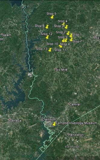
9 Field Trip Stops 8

10 The field trip begins in the Sunset Quadrangle mapped by Garihan. You will be seeing an east to west transect of the footwall, hanging wall, then footwall mapping units. See Figure 3 for structural clarification. Stop 1. Massengill Memorial Rd. Looking towards the south, there is a saprolite exposure displaying interfoliated amphibolite and mica amphibole schist. Garihan (2005) interpreted this transition as a visible exposure of the Seneca Fault. The upper part of the exposure (Figure 5) reveals a nearly flat lying weathered biotite gneiss belonging to the Tallulah Falls Formation (hanging wall) thrust over weathered footwall rocks dipping to the east. Garihan has mapped this as a klippe of Tallulah Falls Formation (Six Mile Trust sheet) surrounded by Walhalla Nappe rocks. Figure 4. Inclined foliation of footwall intersecting overlying subhorizontal foliation. Orientation of underlying foliation: N32W/36NE. Exposed machete is approximately 1ft in length. Yellow line denotes thrust fault associated with Seneca fault. 9
11 Stop 2. Intersection of Windmont & Skyland Rds. On the north side of the road in the ditch and embankment is an exposure of Tallulah Falls mica amphibole schist associated with the hanging wall. Stop 3. AR Lewis Elementary School North and south ditch exposures of porphyroblastic Tallulah Falls biotite gneiss. Stop 4. Martin Grove Church Outcrop to the south of the roads contains a large exposure of leucocratic Table Rock gneiss. Stop 5. Little Eastatoee Rd. The Nine Times ultramafic body is found in this location. This ultramafic body is a greenishgold colored schist and contains the minerals clinoamphibole and chlorite (Gober, 2005). Stop 6. Lunch Crowe Creek Boat Access overlooking Lake Keowee. After lunch, we will go to the Six Mile Quadrangle and perform an east to west transect of hanging and footwall formations. 10
. Figure 6. Crenulated schist boulder with axial planar cleavage forming lineations.")
12 Stop 8. Concord Church Rd. Vertically oriented mica schist with locally occurring crenulated cleavage (Figure 6). Amphibolite pods are emplaced in the schist body (Figure 7). Figure 6. Crenulated schist boulder with axial planar cleavage forming lineations. Yellow line denotes crenulation. 11

13 Figure 7. Amphibolite pods emplaced in red colored schist. Stop 9. Brandy Ln. Outcrop of locally crenulated, mica-garnet-sillimanite-schist on north side of road. The red colored schist is rich with garnets that have been differentially weathered to iron oxides. A photomicrograph (Figure 8) of the schist reveals that the interior of the garnets are preserved while the rim and fractures have been replaced. 12

.")
14 Iron oxide Garnet Sillimanite Figure 8. Photomicrograph showing garnet with iron oxide halo. Stop 10. Brandy Ln. Outcrop of porphyroblastic hornblende gneiss on south side of road with feldspar and quartz porphyroblasts ranging from 0.1-1cm (Figure 9). Lithologic change from the last stop is interpreted as crossing the Seneca Fault from the hanging wall to footwall. Figure 9. Hornblende gneiss with porphyroblastic texture. 13

.")
15 Stop 11. Mountain View Church Small outcrop of garnet-mica-schist on west side of road opposite church parking lot. Beware of vicious dog protecting sheep in adjacent field (Figure 10).. Figure 10. Victoria taming the beast. Stop 12. Ferguson Rd. Outcrop of leucocratic Table Rock Gneiss on the south side of road (Figure 11). The drastic change in rock type from last stop is interpreted to be the Seneca Fault. Figure 11. Outcrop of Table Rock gneiss. 14
 stated that color is potentially related to shearing. Stop 14. Mile Creek Shoals Creek exposures of Tallulah Falls biotite gneiss (Figure 12). Figure 12.")
16 Stop 13. Highway 133 (optional if time permitting) Outcrop of green-colored schist of unknown lithology with adjacent amphibolite and localized folding. Garihan (personal communication, 2015) stated that color is potentially related to shearing. Stop 14. Mile Creek Shoals Creek exposures of Tallulah Falls biotite gneiss (Figure 12). Figure 12. Tallulah Falls gneiss exposed along Mile Creek. 15
 in the upstate is unrivaled.")
17 Acknowledgement This work and field trip would not have been possible without the tremendous contribution of Jack Garihan. His ongoing quest to map geologic quads (14 and counting) in the upstate is unrivaled. While that is a remarkable legacy, he will be remembered mainly by these authors through his willingness to mentor (Figure 13) and translate complex geologic concepts into ordinary language. Jack has left us much richer both scientifically and personally. Figure 13. Jack and Victoria conducting an in-field mapping session. 16
EESC 4701: Igneous and Metamorphic Petrology METAMORPHIC ROCKS LAB 8 HANDOUT
 Sources: Caltech, Cornell, UCSC, TAMIU Introduction EESC 4701: Igneous and Metamorphic Petrology METAMORPHIC ROCKS LAB 8 HANDOUT Metamorphism is the process by which physical and chemical changes in a
Appendix A2: Detailed description of all results
 Appendix A2: Detailed description of all results This Appendix presents detailed descriptions of all results in this study. It is presented separately in order to streamline the main paper, and to provide
GEOLOGY OF THAILAND (METAMORPHIC ROCKS)
") GEOLOGY OF THAILAND (METAMORPHIC ROCKS) High-Grade Metamorphic Rocks (Precambrian?) Low-Grade Metamorphic Rocks (Lower Paleozoic) 1 THAILAND EXPLANATION Lower Paleozoic Rocks (Low Grade) Precambrian (?)
GEOLOGY OF THAILAND (METAMORPHIC ROCKS) High-Grade Metamorphic Rocks (Precambrian?) Low-Grade Metamorphic Rocks (Lower Paleozoic) 1 THAILAND EXPLANATION Lower Paleozoic Rocks (Low Grade) Precambrian (?)
Introduction to Geology Spring 2008
 MIT OpenCourseWare http://ocw.mit.edu 12.001 Introduction to Geology Spring 2008 For information about citing these materials or our Terms of Use, visit: http://ocw.mit.edu/terms. Regional metamorphism
Chapter 8 Lecture. Earth: An Introduction to Physical Geology. Twelfth Edition. Metamorphism. Rocks. Tarbuck and Lutgens Pearson Education, Inc.
 Chapter 8 Lecture Earth: An Introduction to Physical Geology Twelfth Edition Metamorphism and dmetamorphic Rocks Tarbuck and Lutgens Chapter 8 Metamorphic Rocks What Is Metamorphism? Metamorphism means
Prof. Tejas S Patil Dept Of Geology M.J.College.
 Prof. Tejas S Patil Dept Of Geology M.J.College. Metamorphic rocks When rocks are baked by heat of molten magma or squeezed by the movements of huge tectonic plates or by the pressure of overlying thick
CHAPTER 3.3: METAMORPHIC ROCKS
 CHAPTER 3.3: METAMORPHIC ROCKS Introduction Metamorphism - the process of changes in texture and mineralogy of pre-existing rock due to changes in temperature and/or pressure. Metamorphic means change
Understanding Earth Fifth Edition
 Understanding Earth Fifth Edition Grotzinger Jordan Press Siever Chapter 6: METAMORPHISM Modification of Rocks by Temperature and Pressure Lecturer: H Mohammadzadeh Assistant professors, Department of
Hand specimen descriptions of metamorphic rocks
 Hand specimen descriptions of metamorphic rocks Hand specimen descriptions for metamorphic rocks are like those for igneous rocks. The objective is to tell someone looking at it everything they need to
Metamorphism: summary in haiku form
 Metamorphism & Metamorphic Rocks Earth, Chapter 8 Metamorphism: summary in haiku form Shape-shifters in crust. Just add heat and/or pressure. Keep it solid please! What Is Metamorphism? Metamorphism means
"When Gregor Samsa woke up one morning from unsettling dreams, he found himself changed into a monstrous bug. Metamorphosis, by Franz Kafka
 Metamorphosis "When Gregor Samsa woke up one morning from unsettling dreams, he found himself changed into a monstrous bug. Metamorphosis, by Franz Kafka Metamorphism The transformation of rock by temperature
Engineering Geology ECIV 3302
 Engineering Geology ECIV 3302 Instructor : Dr. Jehad Hamad 2019-2018 Chapter (7) Metamorphic Rocks Chapter 7 Metamorphism and Metamorphic Rocks Metamorphism The transition of one rock into another by temperatures
Metamorphism and Metamorphic Rocks Earth - Chapter Pearson Education, Inc.
 Metamorphism and Metamorphic Rocks Earth - Chapter 8 Metamorphism Transition of one rock into another by temperatures and/or pressures unlike those in which it formed Metamorphic rocks are produced from:
Metamorphism & Metamorphic Rocks
 1 2 3 4 5 6 7 8 9 10 11 & Metamorphic Rocks Earth 9 th edition, Chapter 8 Mass wasting: summary in haiku form Shape-shifters in crust. Just add heat and/or pressure. Keep it solid please! Key Concepts
 27 Figure 7 Poorly cleaved, massive, light-weathering Bomoseen graywacke outcrop located on Brandon Mountain Road. Figure 8 Photomicrograph of Bomoseen graywacke. Subangular, poorly sorted quartz grains
Marshall Shore Town Park, Liberty, Maine
 Maine Geologic Facts and Localities August, 2005 Marshall Shore Town Park, Liberty, Maine 44 22 33.04 N, 69 21 9.19 W Text by Henry N. Berry IV, Department of Agriculture, Conservation & Forestry 1 Introduction
Stratigraphy and structure of the Ganson Hill area: northern Taconic Allochthon
 University at Albany, State University of New York Scholars Archive Geology Theses and Dissertations Atmospheric and Environmental Sciences 1985 Stratigraphy and structure of the Ganson Hill area: northern
Lab 6 - Identification of Metamorphic Rocks
 Lab 6 - Identification of Metamorphic Rocks Page - Introduction Metamorphic rocks are the third great rock group. The term meta means to change and morph means form. Metamorphic rocks are rocks who have
Appendix 11. Geology. of the. I60 area
 Appendix 11 Geology of the I60 area 1. Locality The locality of the I60 area is as follows; Northwestern corner; UTM_EW 530513, UTM_NS 7345741 Southwestern corner; UTM_EW 530418, UTM_NS 7301454 Northeastern
Chapter - IV PETROGRAPHY. Petrographic studies are an integral part of any structural or petrological studies in
 Chapter - IV PETROGRAPHY 4.1. Introduction Petrographic studies are an integral part of any structural or petrological studies in identifying the mineral assemblages, assigning nomenclature and identifying
NOA ASSESSMENT HARRIS QUARRY MENDOCINO COUNTY, CALIFORNIA TABLE OF CONTENTS
 NOA ASSESSMENT HARRIS QUARRY MENDOCINO COUNTY, CALIFORNIA TABLE OF CONTENTS Introduction... 1 Scope of Services... 1 Project Location and Description... 1 Geologic Setting... 1 Regional Geology... 1 Site
Metamorphic Rocks and the Rock Cycle
 Petrology Session 3 Metamorphic Rocks and the Rock Cycle Presented by Dr. I Wayan Warmada warmada@gmail.com What are Rocks? Most rocks are an aggregate of one or more minerals, and a few rocks are composed
Big Island Field Trip
 Big Island Field Trip Space Still Available Group Airline Tickets May be available if enough people sign on If interested send email to Greg Ravizza Planning Meeting Next Week Will
LOW GRADE PRECAMBRIAN ROCKS OF THE CENTRAL GRAVELLY RANGE, SW MONTANA
 LOW GRADE PRECAMBRIA ROCKS OF THE CETRAL GRAVELLY RAGE, SW MOTAA ELIZABETH KLEI Amherst College Sponsor: Tekla Harms and Jack Cheney ITRODUCTIO Laramide uplift of the southern Gravelly Range of southwestern
READING QUESTIONS: Metamorphic Rocks GEOL /WI 47 pts. 3. Define metamorphic grade.(2 pts)
") READING QUESTIONS: Metamorphic Rocks GEOL 131 18/WI 47 pts NAME DUE: Tuesday, February 6 What is Metamorphism? (p. 102-103) 1. What is meant by the statement Every metamorphic rock has a parent rock? (2
READING QUESTIONS: Metamorphic Rocks GEOL 131 18/WI 47 pts NAME DUE: Tuesday, February 6 What is Metamorphism? (p. 102-103) 1. What is meant by the statement Every metamorphic rock has a parent rock? (2
GEOL Lab 11 (Metamorphic Rocks in Hand Sample and Thin Section)
") GEOL 333 - Lab 11 (Metamorphic Rocks in Hand Sample and Thin Section) Introduction - Metamorphic rock forms from any pre-existing rock that undergoes changes due to intense heat and pressure without melting.
GEOL 333 - Lab 11 (Metamorphic Rocks in Hand Sample and Thin Section) Introduction - Metamorphic rock forms from any pre-existing rock that undergoes changes due to intense heat and pressure without melting.
Lecture 5 Sedimentary rocks Recap+ continued. and Metamorphic rocks!
 Lecture 5 Sedimentary rocks Recap+ continued and Metamorphic rocks! Metamorphism Process that leads to changes in: Mineralogy Texture Sometimes chemical composition Metamorphic rocks are produced from
Table 7.1 Mineralogy of metamorphic rocks related to protolith and grade
 Geology 101 Name(s): Lab 7: Metamorphic rocks Metamorphic rocks have been subjected to sufficient heat and/or pressure to melt some of their constituent minerals, but not all of them. As a result of this
Metamorphic Rock Origin and Identification
 Metamorphic Rock Origin and Identification Physical Geology GEOL 101 Lab Ray Rector - Instructor http://www.rockhounds.com/rockshop/rockkey/index.html http://earthsci.org/education/teacher/basicgeol/meta/meta.html
Part 2: Metamorphic features. Foliation, cleavage, lineation. Chapter 15
 Part 2: Metamorphic features Chapter 15 Foliation, cleavage, lineation The terms foliation and cleavage in metamorphic rocks have formal definitions, but their colloquial use in the field is commonly haphazard
lecture 7 Foliations & lineations
 Kristallingeologie lecture 7 Foliations & lineations 28 participants Results test A, 2008 Maximum 70 points Pass!35 points (!50%) Best result 67 points Average result 54 points ("2.3) Worst result 30 points
Introduction. Introduction. Chapter 7. Important Points: Metamorphism is driven by Earth s s internal heat
 Chapter 7 Metamorphism and Metamorphic Rocks Introduction Metamorphism - The transformation of rocks, usually beneath Earth's surface, as the result of heat, pressure, and/or fluid activity, produces metamorphic
Metamorphic Rock Origin and Identification
 Metamorphic Rock Origin and Identification Geology Laboratory GEOL 101 Lab Ray Rector - Instructor http://www.rockhounds.com/rockshop/rockkey/index.html http://earthsci.org/education/teacher/basicgeol/meta/meta.html
APPENDIX 2 Table 2. Sample descriptions
 Table 2. descriptions 225 Felsic gneiss, fine-grained and very light-gray. From the upper part of the lower of the two layers, which connect. 226 Amphibolite, even-grained, fine-grained, medium-gray, little
Summary of Rover Metals Geologic Mapping Program at the Up Town Gold Project, Northwest Territories
 October 13, 2017 Summary of Rover Metals Geologic Mapping Program at the Up Town Gold Project, Northwest Territories Vancouver, British Columbia, Canada - Rover Metals Corp., Rover, is pleased to provide
2013 GEOLOGICAL ASSESSMENT REPORT SHERIDAN HILL PROPERTY
 2013 GEOLOGICAL ASSESSMENT REPORT ON THE SHERIDAN HILL PROPERTY NEW WESTMINSTER MINING DIVISION BRITISH COLUMBIA NTS 092G07 49 16 31 NORTH LATITUDE, 122 39 48 WEST LONGITUDE PREPARED FOR Sheridan Hill
R.Suhasini., Assistant Professor Page 1
 UNIT I PHYSICAL GEOLOGY Geology in civil engineering branches of geology structure of earth and its composition weathering of rocks scale of weathering soils - landforms and processes associated with river,
Questions for the Edwards formation
 Name: Professor name: Class Time: The Virtual Field trip is to be completed by your self. You should not work with a partner. This is not group work. Nor should you search for answers on the internet.
Laboratory #6: METAMORPHIC ROCKS
 Name: Lab day (circle one): Tuesday Wednesday Thursday CEEES/SC 10110L-20110L Planet Earth Laboratory Laboratory #6: METAMORPHIC ROCKS Note: In order for these labs to be marked and returned to you before
PETROGRAFI BATUAN METAMORF
 PETROGRAFI BATUAN METAMORF OLEH : AGUS HENDRATNO Laboratorium Geologi Optik Jurusan Teknik Geologi Fakultas Teknik Universitas Gadjah Mada Yogyakarta Quartz metamorf As deformation increases, the quartz
GY111 Earth Materials Practice Final Exam
 I. True/False Questions: circle a T for true or F for false (10% total -or- 0.5 per) 1. (T F) The Uranium used in nuclear power plants may explode if not controlled properly. 2. (T F) Natural Gas is an
Fig. Captions. Fig. 1. Generalized geologic map of eastern Nepal after Akiba et al. (1973), Carosi et al. (1993b),
, Carosi et al. (1993b),") 41 Fig. Captions Fig. 1. Generalized geologic map of eastern Nepal after Akiba et al. (1973), Carosi et al. (1993b), Lombardo et al. (1993), and our field interpretations. The upper left inset shows the
41 Fig. Captions Fig. 1. Generalized geologic map of eastern Nepal after Akiba et al. (1973), Carosi et al. (1993b), Lombardo et al. (1993), and our field interpretations. The upper left inset shows the
Procedure: Then: Your ESRT and a pencil or pen And your
 Name: KEY Date: / / Lab Title: Learn about Metamorphic Rocks - USING your >>>>>>>>>> Class Period: Lab #: _ Intro: Metamorphic Rocks form wherever enough heat and/or pressure exist to morph (change) available
Metamorphic Rocks. Metamorphic rocks. Formed by heat, pressure and fluid activity
 Metamorphic Rocks Most figures and tables contained here are from course text: Understanding Earth Fourth Edition by Frank Press, Raymond Siever, John Grotzinger, and Thomas H. Jordan Metamorphic rocks
GEOLOGIC MAPS PART II
 EARTH AND ENVIRONMENT THROUGH TIME LABORATORY - EES 1005 LABORATORY FIVE GEOLOGIC MAPS PART II Introduction Geologic maps of orogenic belts are much more complex than maps of the stable interior. Just
MEMO. TO: Dennis Lapoint CC: FROM: Eriaan Wirosono DATE: April, 20 th 2014 SUBJECT: Exploration activity report March-April 2014_EW
 TO: Dennis Lapoint CC: FROM: Eriaan Wirosono DATE: April, 20 th 2014 SUBJECT: Exploration activity report March-April 2014_EW MEMO 1. Highlights and Productivity Overview pan sampling on target Areas 1
The Geology of Two Lights State Park. Cape Elizabeth, Maine
 Maine Geologic Facts and Localities June, 2002 Cape Elizabeth, Maine 43 33 33.48 N, 70 12 13.32 W Text by Henry N. Berry IV and Robert G. Marvinney, Department of Agriculture, Conservation & Forestry 1
Falmouth Town Landing, Falmouth, Maine
 Maine Geologic Facts and Localities April, 2018 Falmouth Town Landing, Falmouth, Maine 43 o 43 57.2 N, 70 o 12 16.7 W Text by Ian Hillenbrand, Department of Agriculture, Conservation & Forestry 1 Photo
GEOLOGY 435 FIELD EXERCISE 2, SPRING SKETCHING, DESCRIBING, AND MAPPING EXPOSURES OBJECTIVES:
 OBJECTIVES: GEOLOGY 435 FIELD EXERCISE 2, SPRING 2016 -- SKETCHING, DESCRIBING, AND MAPPING EXPOSURES To develop and refine your field skills in: 1. observation and rock and sediment description 2. sketching
BUREAU OF MINERAL RESOURCES GEOLOGY AND GEOPHYSICS,
 ^ ^c ^ / o/./ 3 4f c,3 COMMONWEALTH OF AUSTRALIA. DEPARTMENT OF NATIONAL DEVELOPMENT. BUREAU OF MINERAL RESOURCES GEOLOGY AND GEOPHYSICS, RECORDS. 1 960/134 GEOLOGY OF THE MAVIS TIN LEASE by P.G. Dunn.
Objectives of this Lab. Introduction. The Petrographic Microscope
 Geological Sciences 101 Lab #9 Introduction to Petrology Objectives of this Lab 1. Understand how the minerals and textures of rocks reflect the processes by which they were formed. 2. Understand how rocks
Supplementary Table 1.
 Supplementary Table 1. Compositional groups, typical sample numbers and location with their bulk compositional, mineralogical and petrographic characteristics at different metamorphic grades. Metamorphic
Metamorphism: Alteration of Rocks by Temperature and Pressure
 CHAPTER 6 Metamorphism: Alteration of Rocks by Temperature and Pressure Chapter Summary Metamorphism is the alteration in the solid state of preexisting rocks, including older metamorphic rocks. Increases
Report. Mining Claim SO Butt Township. District of Nipissing. Southern Ontario Mining District. Richard Keevil ~ Geologist. August 29,2006.
 Report On Mining Claim SO 1077365 Butt Township District of Nipissing Southern Ontario Mining District ~ "'_I ""'..1 D I..:"'.U&O... ~u ~]. Richard Keevil ~ Geologist August 29,2006. Richard R. Keevil,
Practice Test Rocks and Minerals. Name. Page 1
 Name Practice Test Rocks and Minerals 1. Which rock would be the best source of the mineral garnet? A) basalt B) limestone C) schist D) slate 2. Which mineral is mined for its iron content? A) hematite
Lab 6: Metamorphic Rocks
 Introduction The Earth s crust is in a constant state of change. For example, plutonic igneous rocks are exposed at the surface through uplift and erosion. Many minerals within igneous rocks are unstable
Lab: Metamorphism: minerals, rocks and plate tectonics!
 Introduction The Earth s crust is in a constant state of change. For example, plutonic igneous rocks are exposed at the surface through uplift and erosion. Many minerals within igneous rocks are unstable
ROAD LOG FOR THE ANNUAL EXCURSION OF THE CAROLINA GEOLOGICAL SOCIETY 1
 ROAD LOG FOR THE ANNUAL EXCURSION OF THE CAROLINA GEOLOGICAL SOCIETY 1 OCTOBER 24 25, 1953 W.C. Overstreet, P.K. Theobald, Jr., and N.P. Cuppels 1.Publication authorized by the Director, U.S. Geological
Review - Unit 2 - Rocks and Minerals
 Review - Unit 2 - Rocks and Minerals Base your answers to questions 1 and 2 on the diagram below, which shows the results of three different physical tests, A, B, and C, that were performed on a mineral.
Name. GEOL.5220 Structural Geology Faults, Folds, Outcrop Patterns and Geologic Maps. I. Properties of Earth Materials
 I. Properties of Earth Materials GEOL.5220 Structural Geology Faults, Folds, Outcrop Patterns and Geologic Maps Name When rocks are subjected to differential stress the resulting build-up in strain can
Part I. PRELAB SECTION To be completed before labs starts:
 Student Name: Physical Geology 101 Laboratory #13 Structural Geology II Drawing and Analyzing Folds and Faults Grade: Introduction & Purpose: Structural geology is the study of how geologic rock units
Age (Ma) Age (Ma) Age (Ma)
 Age (Ma) Age (Ma)") 8 Description of Mapped Units 113 ' 46 7.' 29 47 23 21 Tac Anaconda Beds - sediments and volcaniclastics 21 81 19 7 42 11 36 4 68 Kgd 69 8 84 69 8 2 7 22 19 22 49 68 79 89 6 82 21 69 71 79 82 77 9 84 36
8 Description of Mapped Units 113 ' 46 7.' 29 47 23 21 Tac Anaconda Beds - sediments and volcaniclastics 21 81 19 7 42 11 36 4 68 Kgd 69 8 84 69 8 2 7 22 19 22 49 68 79 89 6 82 21 69 71 79 82 77 9 84 36
GS-17. Summary. Previous work. Regional setting. Introduction. Geology
 GS-17 Geology, structure and mineralization of the Ore Fault property, Bird River greenstone belt, southeastern Manitoba (parts of NTS 52L5NE and 52L6NW) by L.A. Murphy 1 and P. Theyer Murphy, L.A. and
40-50 Minutes, 3 minutes per station, 13 Stations, samples provided by UWM and Pierre Couture
 Event: Judge: Rocks & Minerals Pierre couture 40-50 Minutes, 3 minutes per station, 13 Stations, samples provided by UWM and Pierre Couture 1-4 Minerals (50 points total) 5-7 Igneous Rocks (50 points total)
Mishi Lake Gold Property Mishibishu Lake Area, Wawa
 Mishi Lake Gold Property Mishibishu Lake Area, Wawa Location, Accessibility, Infrastructure and Local Resources The property is located 40 km west of Wawa, Ontario, in the Mishibishu Lake Area, Sault Ste.
TECHNICAL REPORT: REGIONAL GEOLOGY AND TECTONICS Resume. Huachon Project, Cerro de Pasco departments, Peru. By: AFC Logistic SAC
 TECHNICAL REPORT: REGIONAL GEOLOGY AND TECTONICS Resume Huachon Project, Cerro de Pasco departments, Peru By: AFC Logistic SAC December 2016 1. INTRODUCTION GPM Metals Peru, in its portfolio of generating
Lesson Seven: Metamorphic Rocks
 Name: Date: GEOL1 Physical Geology Laboratory Manual College of the Redwoods Lesson Seven: Metamorphic Rocks Background Reading: Metamorphic Rocks Metamorphic Rocks These are rocks that have been changed
Metamorphism occurs where equi P-T is disturbed
 Metamorphism occurs where equi P-T is disturbed Steady-state geotherms are disturbed by a variety of processes including plate-tectonic transport of rocks and heat input by intrusion of magma active transport
Trip B-2 VARIATIONS IN L- AND S-TECTONITE ON THE NORTHERN BOUNARY OF THE PISECO LAKE SHEAR ZONE, ADIRONDACK MOUNTAINS, NEW YORK
 Trip B-2 VARIATIONS IN L- AND S-TECTONITE ON THE NORTHERN BOUNARY OF THE PISECO LAKE SHEAR ZONE, ADIRONDACK MOUNTAINS, NEW YORK DAMIAN PIASCHYK 1, DAVID VALENTINO 2, GARY SOLAR 3, JEFFREY R. CHIARENZELLI
NAME HOMEWORK ASSIGNMENT #3 MATERIAL COVERS CHAPTERS 8, 9, 10, 11
 NAME HOMEWORK ASSIGNMENT #3 MATERIAL OVERS HAPTERS 8, 9, 10, 11 Assignment is due the beginning of the class period on November 23, 2004. Answers for each chapter will be discussed in class, as Exam #3
GEOLOGY 470 FIELD EXERCISE 3, SPRING SKETCHING, DESCRIBING, AND MAPPING EXPOSURES
 GEOLOGY 470 FIELD EXERCISE 3, SPRING 2009 -- SKETCHING, DESCRIBING, AND MAPPING EXPOSURES 1 OBJECTIVES: To develop and refine your field skills in: 1. observation and rock and sediment description 2. sketching
ZONED PEGMATITES OF THE MICANITE DISTRICT FREMONT & PARK COUNTIES, COLORADO
 ZONED PEGMATITES OF THE MICANITE DISTRICT FREMONT & PARK COUNTIES, COLORADO By Andy Weinzapfel INTRODUCTION The below article is based on library research and field work conducted during 2007. The Micanite
Metamorphic Energy Flow. Categories of Metamorphism. Inherited Protolith Character. Inherited Fabric. Chemical Composition
 Metamorphic Energy Flow Categories of Metamorphism Best, Chapter 10 Metamorphic processes are endothermic They absorb heat and mechanical energy Absorption of heat in orogenic belts Causes growth of mineral
Metamorphism (means changed form
 Metamorphism (means changed form) is recrystallization without melting of a previously existing rock at depth in response to a change in the environment of temperature, pressure, and fluids. Common minerals
Undergraduate Review. Jessica Sousa. Volume 4 Article 13
 Undergraduate Review Volume 4 Article 13 2008 Kinematic Analysis of Mylonitic Rocks, Southern Ruby Mountains, SW Montana: Evidence for Proterozoic Orogenic Crustal Thickening and Topographic Collapse Jessica
Amphibole. Note the purple to blue-gray pleochroism in the glaucophane in this slide.
 Amphibole Glaucophane blue Note the purple to blue-gray pleochroism in the glaucophane in this slide. Glaucophane blue Note the anomalous blue-gray interference colors in the glaucophane in this slide.
Term 1 final review ES
 Name: Date: 1. t what approximate altitude in the atmosphere can stratospheric ozone be found?. 10 km. 30 km. 70 km D. 100 km 2. What percentage of Earth s history represents human existence?. less than
McClelland & Oldow, p. 1
 McClelland & Oldow, p. 1 U-Pb Analytical Methods Zircons were separated from each of the seven 1 to 4 kg samples samples (see Fig. 1 for locations) by standard crushing and gravimetric techniques, picked
Hornblende (Ca,Na)2-3(Fe,Mg,Al)5Si6(Si,Al)2O22(OH)2. Kaolinite (clay) Al2Si2O5(OH)4. Foliation ANIMATION
2-3(Fe,Mg,Al)5Si6(Si,Al)2O22(OH)2. Kaolinite (clay) Al2Si2O5(OH)4. Foliation ANIMATION") 1 Hornblende (Ca,Na)2-3(Fe,Mg,Al)5Si6(Si,Al)2O22(OH)2 Kaolinite (clay) Al2Si2O5(OH)4 Foliation ANIMATION 2 Grade Foliation type How does change as grade increases? Density increases (volume shrinks) Foliation
1 Hornblende (Ca,Na)2-3(Fe,Mg,Al)5Si6(Si,Al)2O22(OH)2 Kaolinite (clay) Al2Si2O5(OH)4 Foliation ANIMATION 2 Grade Foliation type How does change as grade increases? Density increases (volume shrinks) Foliation
Metamorphism / Metamorphic Rocks
 Metamorphism / Metamorphic Rocks Metamorphism: occurs when rocks are subjected to heat, pressure, and/or other environmental conditions - The rock remains a solid during this time period - Why Should You
Crustal Deformation Earth - Chapter Pearson Education, Inc.
 Crustal Deformation Earth - Chapter 10 Structural Geology Structural geologists study the architecture and processes responsible for deformation of Earth s crust. A working knowledge of rock structures
Chapter 15 Structures
 Chapter 15 Structures Plummer/McGeary/Carlson (c) The McGraw-Hill Companies, Inc. TECTONIC FORCES AT WORK Stress & Strain Stress Strain Compressive stress Shortening strain Tensional stress stretching
10 cm. 5 cm. 10 cm. glacial striae. glacial striae
 GSA DATA REPOSITORY Druguet et al. Supplementary Photographs All photographs are vertical shots of sub-horizontal outcrops. All contacts are sub-vertical except for DR7 (dips indicated on picture). quartzitic
Topics that will be discussed
 Topics that will be discussed The Rock Cycle Igneous Rock Sedimentary Rock Metamorphic Rock The Rock Cycle -Rocks The parent material for all rocks is MAGMA. What is MAGMA? -Rock forming Minerals Are:
CE6301 ENGINEERING GEOLOGY UNIT I 2 MARKS
 YEAR : II SEMESTER : III DEPARTMENT : CIVIL CE6301 ENGINEERING GEOLOGY UNIT I 1. What is Physical weathering? 2. Define Stratigraphy and Palaeontology? 3. What is meant by chemical weathering 4. Describe
Accreted Terranes. Photos by Jim Cash Moscow High School
 Accreted Terranes Photos by Jim Cash Moscow High School This unit contains photos from Hells Canyon, Rapid River, McCall to New Meadows, Kleinschmidt Grade, and Slate Creek Seven Devils Area: View of Seven
GY111 Earth Materials Practice Final Exam
 I. True/False Questions: circle a T for true or F for false (10% total -or- 0.5 per) (Correct answer in red) 1. (T F) The Uranium used in nuclear power plants may explode if not controlled properly. 2.
GONDWANA 14 East Meets West Field Trip PostGo1 - Ribeira and Brasília belts in the context of West Gondwana
 GONDWANA 14 East Meets West Field Trip PostGo1 - Ribeira and Brasília belts in the context of West Gondwana The aim of the field trip is to discuss the tectonic episodes of West Gondwana amalgamation in
Report of Activities 2003 Published by: Manitoba Industry, Economic Development and Mines Manitoba Geological Survey, 2003.
 Report of Activities 2003 Published by: Manitoba Industry, Economic Development and Mines Manitoba Geological Survey, 2003. ERRATA: The publisher/department name in the bibliographic reference cited immediately
A Geological Tour of Tumbledown Mountain, Maine
 Maine Geologic Facts and Localities April, 1998 A Geological Tour of Tumbledown Mountain, Maine 44 45 3.21 N, 70 32 50.24 W Text by Robert G. Marvinney, Department of Agriculture, Conservation & Forestry
Metamorphism and Metamorphic Rocks
 Page 1 of 13 EENS 1110 Tulane University Physical Geology Prof. Stephen A. Nelson Metamorphism and Metamorphic Rocks This page last updated on 25-Sep-2017 Definition of Metamorphism The word "Metamorphism"
Metamorphic Petrology. Jen Parks ESC 310, x6999
 Metamorphic Petrology Jen Parks ESC 310, x6999 jeparks@sciborg.uwaterloo.ca Definition of Metamorphism The IUGS-SCMR SCMR definition of metamorphism: Metamorphism is a subsolidus process leading to changes
GEOL Introductory Geology: Exploring Planet Earth Fall 2010 Test #2 October 18, 2010
 GEOL 101 - Introductory Geology: Exploring Planet Earth Fall 2010 Test #2 October 18, 2010 Name KEY ID# KEY Multiple choice questions (2 points each). 1. What type of metamorphic rock is formed over large
GEOL FORENSIC GEOLOGY ROCK IDENTIFICATION
 GEOL.2150 - FORENSIC GEOLOGY ROCK IDENTIFICATION Name I. Introduction There are three basic types of rocks - igneous, sedimentary, and metamorphic: Igneous. Igneous rocks have solidified from molten matter
Provided by Tasa Graphic Arts, Inc. for An Introduction to Structural Methods DVD-ROM
 Provided by Tasa Graphic Arts, Inc. for An Introduction to Structural Methods DVD-ROM http://www.tasagraphicarts.com/progstruct.html AN INTRODUCTION TO STRUCTURAL METHODS - DETAILED CONTENTS: (Navigate
RR#7 - Multiple Choice
 1. Which mineral is mined for its iron content? 1) hematite 2) fluorite 3) galena 4) talc 2. Which rock is composed of the mineral halite that formed when seawater evaporated? 1) limestone 2) dolostone
Engineering Geology. Metamorphic Rocks. Hussien Al - deeky
 Metamorphic Rocks Hussien Al - deeky 1 Definition Metamorphic rock is the result of the transformation of an existing rock type, the protolith (parent rock), in a process called metamorphism, which means
MINERALOGY LABORATORY Metamorphic Rocks and Minerals
 Some of the samples used in Mineralogy Lab are museum specimens. Please do not destroy or heist them. You can do just about anything you want to the grungy ones, but be nice to the pretty specimens as
Excursion guide NW Skåne, NGEA 01, 2018 PART 3. ASSIGNMENTS
 Excursion guide NW Skåne, NGEA 01, 2018 PART 3. ASSIGNMENTS by Associate Prof. Jonas Åkerman 1 Cover photo; The NW exposed coastline at Josefinelust with coarse beach boulders (Sw. malar ), gneiss is the
An Overview of Graphite Projects from Asia to Africa. Dr Mike Cunningham SRK Consulting (Australasia) Pty. Ltd.
 Pty. Ltd.") An Overview of Graphite Projects from Asia to Africa Dr Mike Cunningham SRK Consulting (Australasia) Pty. Ltd. Acknowledgements PT. Granfindo Nusantara RS Mines Pty Ltd Geological Survey and Mining Bureau
An Overview of Graphite Projects from Asia to Africa Dr Mike Cunningham SRK Consulting (Australasia) Pty. Ltd. Acknowledgements PT. Granfindo Nusantara RS Mines Pty Ltd Geological Survey and Mining Bureau