Passive-aggressive margin seismicity revised December 22, Mineral, Virginia, earthquake illustrates seismicity of a passive-aggressive margin
|
|
|
- Kevin Hensley
- 6 years ago
- Views:
Transcription
1 Passive-aggressive margin seismicity revised December 22, Mineral, Virginia, earthquake illustrates seismicity of a passive-aggressive margin Emily Wolin 1, Seth Stein 1, Frank Pazzaglia 2, Anne Meltzer 2, Alan Kafka 3 1 Department of Earth and Planetary Sciences, Northwestern University Evanston, IL Department of Earth and Environmental Sciences, Lehigh University, Bethlehem, PA Weston Observatory, Department of Earth and Environmental Sciences, Boston College, Weston, MA "Passive-Aggressive behavior is a form of covert abuse. Covert abuse is subtle and veiled or disguised by actions that appear to be normal. [ Abstract The August 2011 M 5.8 Mineral, Virginia, earthquake that shook much of the northeastern U.S. dramatically demonstrated that passive continental margins sometimes have large earthquakes. We illustrate some general aspects of such earthquakes and outline some of the many unresolved questions about them. They occur both offshore and onshore, reaching magnitude 7, and are thought to reflect reactivation of favorably-oriented, generally margin-parallel, faults created during one or more Wilson cycles by the modern stress field. They pose both tsunami and shaking hazards. However, their specific geologic setting and causes are unclear because large magnitude events occur infrequently, microseismicity is not well recorded, and there is little, if
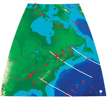
2 Passive-aggressive margin seismicity revised December 22, any, surface expression of repeated ruptures. Thus presently active seismic zones may be areas associated with higher seismicity over the long term, the present loci of activity that migrates, or aftershock zones of large prehistoric earthquakes. The stresses causing the earthquakes may result from platewide driving forces, glacial isostatic adjustment, localized margin stresses, and/or dynamic topography. The resulting uncertainties make developing cost-effective mitigation strategies a major challenge. Progress on these issues requires integrating seismic, geodetic, and geological techniques. Introduction On August 23, 2011 residents of the U.S.'s east coast may have felt that the earth had turned passive-aggressive, when they were surprised by shaking from the M 5.8 Mineral, Virginia earthquake. Many had assumed that earthquakes large enough to damage structures like the Washington Monument did not occur in the region. From a tectonic standpoint, their assumption made sense. Eastern North America is a "passive" continental margin, along which the continent and seafloor are part of the same plate. The fundamental tenet of plate tectonics, articulated by J. Tuzo Wilson [1965], is that plates are not readily deformed except at their edges." Hence if plates were the ideal rigid entities assumed in many applications, such as calculating plate motions, passive continental margins should be seismically passive. In reality, however, large and damaging earthquakes occur along passive margins worldwide [Stein et al, 1979; 1989; Schulte and Mooney, 2005] (Figure 1). These earthquakes release a disproportionate share, about 25%, of the net seismic moment release in nominally-stable
3 Passive-aggressive margin seismicity revised December 22, continental regions [Schulte and Mooney, 2005]. They were recognized even prior to the formulation of plate tectonics by Gutenberg and Richter [1954], who noted, "Nearly all stable masses exhibit marginal features which are seismically active." Hence although passive margin earthquakes are only a very minor component of global seismicity, they are not uncommon, and can be thought of as analogous to the medical case of a "common rare disease." However, no comprehensive model exists to explain these earthquakes. We know little about their causes and the possible hazards they pose, partly because they are relatively rare, due to the slow deformation at these margins. They are generally thought to reflect reactivation of ancient, favorably-oriented, faults created by previous continental collision and breakup. This view is consistent with geological observations that passive margins are often reactivated in compression (Cloetingth et al., 2008). However, verifying and using this generalization is difficult. Thus our goal here is to illustrate some general observations about passive margin earthquakes and outline some of the many unresolved questions about them. Eastern North America has impressive examples of passive margin seismicity. The best known in modern times, the 1929 M 7.2 earthquake on the Grand Banks of Newfoundland [Hasegawa and Kanamori, 1987; Bent, 1995], caused a large (~10 11 m 3 ) landslide of thick continental slope sediments, which cut trans-atlantic telegraph cables and generated a tsunami. The resulting 28 fatalities are either all or most of Canada's known deaths from earthquakes. The earthquake was felt as far away as New York and Montreal [ and thus gives a useful comparison with the similar intensity distribution for the largest of the New Madrid earthquake sequence [Hough, 2008].
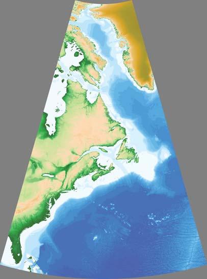
4 Passive-aggressive margin seismicity revised December 22, Other notable events include the 1933 M 7.3 Baffin Bay [Bent, 2002], 1755 M ~6 Cape Ann, Massachusetts [Ebel, 2006], and 1886 M ~7 Charleston [Hough, 2008] earthquakes. Hence the 2011 Virginia earthquake is part of a diffuse seismic zone spanning the continental margin (Figure 2). Offshore earthquake hazards Among the intriguing challenges posed by these earthquakes is assessing their societal hazard. For this purpose, the offshore and onshore earthquakes differ. For onshore earthquakes, the primary hazard is shaking. For large offshore earthquakes like the Grand Banks, the primary hazard can be a resulting tsunami [ten Brink, 2009], because the intensity of strong shaking decreases rapidly with distance. To assess this hazard, a crucial question is whether the slumps and tsunamis require an earthquake trigger, or can arise from slope instability alone. In the former case, the hazard can be assessed using earthquake frequency-magnitude data [Swafford and Stein, 2007]. Studies of the Grand Banks earthquake, the only well studied tsunamigenic earthquake off eastern North America, have come to opposing conclusions. Hasegawa and Kanamori [1987] inferred from first motions and surface wave spectra that the source was a single force, e.g. a landslide. In contrast, Bent [1995] used waveform modeling to infer a double couple or earthquake source. An alternative approach is to consider aftershocks, which result from changes of stress and fault
5 Passive-aggressive margin seismicity revised December 22, properties induced by the main shock. At plate boundaries, plate motion at rates of tens of mm/yr quickly reloads a fault after a large earthquake and overwhelms the effects of the main shock within about a decade. However, faults within continental interiors are reloaded at rates significantly less than 1 mm/yr, allowing aftershocks to continue, potentially, for hundreds of years. A model based on laboratory experiments [Dieterich, 1994], which predicts that the length of aftershock sequences varies inversely with the rate at which faults are loaded, accords with observations from a range of faults [Stein and Liu, 2009]. For example, aftershocks continue today from the 1959 Hebgen Lake, Montana, earthquake, and seismicity in the areas of past large intracontinental earthquakes, including those in New Madrid, Missouri ( ) and Charlevoix, Quebec (1663) appear to be aftershocks. Many small earthquakes in the eastern U.S. may be aftershocks of strong earthquakes that took place hundreds or thousands of years ago [Ebel et al., 2000]. Because a large landslide should not be followed by a long aftershock sequence, studies of aftershocks could make it possible to distinguish landslides triggered by earthquakes from those due to slope instability alone. We thus examined the seismicity of the Grand Banks and Baffin Bay areas between 1920 and 2009 (Figure 3, top). Seismicity in the Grand Banks exhibits a rough linear trend along the fault plane proposed by Bent [1995], although several of the largest aftershocks have been fixed at the main shock epicenter. Seismicity in Baffin Bay is more scattered, either intrinsically or due to location uncertainties [Qamar, 1974; Bent, 2002]. In both areas, the largest (M~5-6) events occur within years of the main shock and within 1-2 fault lengths of its epicenter.
6 Passive-aggressive margin seismicity revised December 22, Assuming that these larger events outline the region where most aftershocks occur, we treat as aftershocks any event in a rectangular region enclosing the main shock and subsequent large events. Choosing such a region was straightforward near the Grand Banks due to the linear trend of epicenters. In Baffin Bay, a scattered distribution of the largest earthquakes and an abundance of recent, small events made selecting an aftershock region more difficult. Our selection was based on the location of the largest aftershocks in the 40 years after the main shock and the geometry of the fault plane [Bent, 2002]. The box shown excludes several M~6-6.5 quakes from as well as the 1963 M 6.3 Baffin Island earthquake. Most of these events occurred too far from the 1933 epicenter to qualify as aftershocks, although many locations for earlier events have considerable uncertainty. We discount the 1963 earthquake as an aftershock due to its thrust mechanism and WNW-striking fault geometry [Stein et al., 1979]. Although selecting these aftershock regions is subjective, our results are robust to variations in size and location of the chosen regions. Figure 3 (bottom) shows event magnitudes versus time for the two regions. Despite the incomplete and nonuniform catalogs, both show decay characteristic of aftershock sequences. The Grand Banks experienced a number of aftershocks of variable magnitude in the same year as the main shock, and several magnitude 5s occur in the next 40 years. In contrast, three aftershocks of magnitude 6 or greater followed the Baffin Bay earthquake, but seismicity decreases between 1950 and Despite these differences, both series show overall decay for several decades that seems to continue today. This similarity presumably reflects the fact that the main shocks occurred in similar tectonic settings, have comparable magnitude, and occurred only four years apart. It thus seems likely that both events were earthquakes.
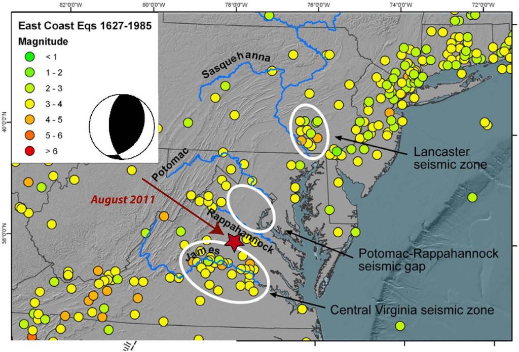
7 Passive-aggressive margin seismicity revised December 22, A resulting question is where to map the hazard from similar earthquakes. Figure 4 illustrates this issue by comparing hazard maps for Canada made in 1985 and The older map shows concentrated high hazard bull's-eyes at the sites of the Grand Banks and Baffin Bay earthquakes, assuming there is something especially hazardous about these locations. The alternative is to assume that similar earthquakes can occur anywhere along the margin, possibly on faults remaining from the most recent phase of rifting. This possibility seems more plausible geologically, and is suggested by the seismicity between the Grand Banks and Baffin Bay, some of which may be aftershocks of prehistoric earthquakes. The 2005 map makes this assumption, and thus shows a "ribbon" of high hazard along the coast, while retaining the bull s-eyes. The same issues apply to the U.S. coast, where present maps do not consider offshore events. Onshore earthquake hazard The hazard due to onshore continental margin earthquakes is illustrated by the 60 deaths caused by the Charleston earthquake and the damage caused by the 2011 Virginia earthquake. A major challenge in assessing this hazard is that the tectonic settings and causes of such earthquakes are unclear. The focal mechanism and aftershock locations [R. Hermann, pers. comm.] for the Virginia earthquake are consistent with reverse faulting on a SE-dipping NE-SW striking fault (Figure 5). The fault trend is roughly parallel to the margin, mapped structures in the Virginia Piedmont [Hughes, 2011], and the Stafford fault system [Mixon and Newell, 1977]. However, the
8 Passive-aggressive margin seismicity revised December 22, earthquake occurred on the northern edge of the central Virginia seismic zone (CVSZ), a seismic trend normal to the fault plane, margin, and associated structures, that has no presently recognized geologic or geomorphic expression. Moreover, there is no obvious topography related to faster rock uplift or differential deformation in this or nearby seismic zones than in adjacent areas that appear largely aseismic. This observation suggests that the CVSZ and similar seismic zones along the margin may not be long-lived concentrations of deformation. Instead, they may be the recent loci of seismicity that migrates [Stein et al., 2009], or aftershock zones of large prehistoric earthquakes. It has been suggested [Sykes, 1978] that seismicity correlates with extensions of Atlantic Ocean fracture zones. However, the larger subsequent earthquake location dataset indicates that this correlation is weak (Figure 6). Causes The forces driving the seismicity are also unclear. On average, stress indicators for the eastern U.S. show compression oriented ENE [Zoback, 1992]. This direction is similar to that predicted by models of intraplate stress due to platewide forces including "ridge push" caused by cooling oceanic lithosphere [Richardson et al., 1979], mantle flow beneath the continent [Forte et al., 2007], and combinations of these and other topographic forces [Ghosh and Holt, 2011]. The observation that seismicity occurs especially along the margins suggests a contribution from local mechanisms causing approximately margin-normal localized stresses [Stein et al., 1989]. These include "spreading" of lower density continental crust over oceanic lithosphere [Bott,
9 Passive-aggressive margin seismicity revised December 22, ], the load of offshore sediment [Walcott, 1972; Turcotte et al., 1977; Cloetingh et al., 1983], and stresses due to the removal of glacial loads [Stein et al., 1979; 1989; Quinlan, 1984]. The possible role of deglaciation in triggering seismicity by perturbing the background stress state has been a subject of interest because two of the largest passive margin earthquakes, 1929 Grand Banks and 1933 Baffin Bay, occur along the deglaciated coast. A challenge in assessing this effect has been that the predicted rates of glacial isostatic adjustment (GIA) and thus the area over which this effect is significant depend crucially on the assumed viscosity structure. For example, Wu and Johnston [2000] find that deglaciation may be significant for earthquakes in the St. Lawrence valley. However, because GIA effects decay rapidly away from the ice margin, they should have little effect in the New Madrid area, unless the viscosities of the crust and upper mantle there are an order of magnitude weaker than surrounding areas [Grollimund and Zoback, 2001], which seems not to be the case [McKenna et al., 2007]. The availability of GPS data has recently made it possible to map the rate of GIA [Sella et al., 2007]. The results (Figure 7) show that these motions are small south of the "hinge line" [approximately at the latitude of the Great Lakes] separating uplift to the north from subsidence to the south. In general, seismic moment release decreases southward along the margin, consistent with the variation in vertical motion rates observed by GPS, suggesting that north of the hinge line GIA is an important contributor to intraplate seismicity. However, south of the hinge line, other stress sources should be more significant. The occurrence of large earthquakes and on other margins that have not been recently glaciated (Figure 1)
10 Passive-aggressive margin seismicity revised December 22, indicates that GIA cannot be the only mechanism at work. A similar conclusion emerges from geological observations of other vertical motions. In particular, in the mid-atlantic region deformed stratigraphic and geomorphic markers, localized high-relief topography, and rapid river incision show uplift of the Piedmont and Appalachians relative to the Coastal Plain for the past 10 Ma, suggesting that the seismicity reflects active and long-term deformation [Pazzaglia and Gardner, 1994; 2000; Pazzaglia et al., 2010]. These motions may reflect dynamic topography resulting from mantle flow [Moucha et al., 2008]. Challenges The Mineral earthquake illustrates our limited knowledge of passive margin earthquakes. The issue is how forces that we do not understand cause motion on faults that have not been identified and hazards that we cannot easily assess. First, we incompletely understand the earthquakes' geologic setting. Most have not yet been associated with specific structures whose geological and paleoseismic history can be studied. Similarly, because these earthquakes are relatively rare, the instrumental seismic record is generally inadequate to map long-lived faults. Thus most of what we know comes from studying the fault planes and aftershock geometries of recent large magnitude earthquakes, which may give little insight into future ones. Second, it is hard to assess the recurrence of large passive margin earthquakes. Except in the Charleston area [Talwani and Schaeffer, 2001], little paleoseismic data exist [Wheeler, 2006].
11 Passive-aggressive margin seismicity revised December 22, As a result, one can only use regional frequency-magnitude data. Third, we are unclear about the force systems loading faults and causing motion on them. Although various models predict stress directions generally consistent with the inferred stress field, it is difficult to discriminate between models. As a result, hazard mappers must chose between drawing high-hazard bull s-eyes at the locations of past earthquakes, which are often not useful predictors of future hazard [Swafford and Stein, 2007; Liu et al., 2011; Stein et al., 2011], or mapping a uniform regional hazard. As Figure 4 shows, the different assumptions yield quite different maps, and a long time will be needed to see which was more useful. As a result, developing a cost-effective mitigation policy is a major challenge. Progress on these issues seems most likely to come slowly via an integrated approach using various techniques. High-precision geodesy can resolve crustal motions as slow as 1 mm/yr [Calais and Stein, 2009]. GPS and InSAR studies will thus be able to identify regions where resolvable strain is accumulating to be released in future earthquakes, or show that any strain accumulation is much slower. Enhancing regional permanent seismological networks and the EarthScope program's USArray will provide better data on large earthquakes and the locations of microseismicity. Seismological, gravity, and magnetic data can be used to identify and map buried and potentially seismogenic faults. Geomorphology and stratigraphy can constrain the long-term deformation of geomorphic and stratigraphic markers, and paleoseismic studies may succeed in identifying the locations of past earthquakes. Once enough data are compiled to
12 Passive-aggressive margin seismicity revised December 22, develop a space-time history of seismicity, modeling studies can explore the dynamics of the fault systems [Li et al., 2009]. A natural question to ask is whether, given these challenges, passive margin earthquakes are a minor curiosity about which research is unlikely to yield results commensurate with the effort involved. Our sense is that the problem is worthy of study precisely because we do not understand how large earthquakes occur where idealized plate tectonics predicts they should not. The eastern U.S.'s population density and the need to expand the nation s energy portfolio, perhaps via offshore drilling and further development of nuclear power, make understanding continental margin earthquakes even more significant. Acknowledgements We thank editor Eric Calais for inviting this paper and Bill Holt and Sierd Cloetingh for helpful reviews. We also thank Mark Carter (USGS) and the residents of Lousia County, VA for help in establishing a seismological and geodetic network to document after-effects of the 2011 Virginia earthquake. REFERENCES Bent, A. L., A complex double-couple source mechanism for the Ms Grand Banks earthquake, Bull. Seismol. Soc. Am., 85, , 1995.
13 Passive-aggressive margin seismicity revised December 22, Bent, A. L., The 1933 Ms= 7.3 Baffin Bay earthquake, Geophys. J. Int., 150, , Bott, M. H. P., Evolution of young continental margins and formation of shelf basins, Tectonophysics, 11, , Calais, E., and S. Stein, Time-variable deformation in the New Madrid seismic zone, Science, 5920, 1442, Cloetingh, S., M. Wortel, and N. Vlaar, State of stress at passive margins and initiation of subduction zones, in Studies in Continental Margin Geology, Am. Assoc. Petrol. Geol. Mem. 34, pp , Cloetingh, S., F. Beekman, P. Ziegler, J. van Wees, and D. Sokoutis, Post-rift compressional reactivation potential of passive margins and extensional basins, in Nature and Origin of Compression in Passive Margins, Geol. Soc. London Spec. Publ. 306, 27-70, Dieterich, J. H., A constitutive law for rate of earthquake production and its application to earthquake clustering, J. Geophys. Res., 99, , Ebel, J.E., The Cape Ann, Massachusetts earthquake of 1755, Seismol. Res. Lett., 77, 74-86, 2006.
14 Passive-aggressive margin seismicity revised December 22, Ebel, J.E., Bonjer, K. and Oncescu, M., Paleoseismicity: seismicity evidence for past large earthquakes, Seismol. Res. Lett. 71, , Forte, A., J. Mitrovica, R. Moucha, N. Simmons, and S. Grand, Descent of the ancient Farallon slab drives localized mantle flow below the New Madrid seismic zone, Geophys. Res. Lett., 34, doi: /2006gl027895, Ghosh, A., and W. E. Holt, Plate motions and stresses from global dynamic models, Science, submitted, Grollimund, B., and M. D. Zoback, Did deglaciation trigger intraplate seismicity in the New Madrid seismic zone?, Geology, 29, , Gutenberg, B., and C. F. Richter, Seismicity of the Earth, Hafner, New York, Hasegawa, H. S., and H. Kanamori, Source mechanism of the magnitude 7.2 Grand Banks earthquake of November 1929, Bull. Seismol. Soc. Am., 77, , Hough, S. E., Large 19th century earthquakes in eastern/central North America, in Historical seismology, edited by J. Frechet, M. Meghraoui, M. Stucchi and J. Vogt, pp , Springer, Dordrecht, Netherlands, 2008.
15 Passive-aggressive margin seismicity revised December 22, Hughes, S., Geology of the northern half of the Ferncliff 7.5' quadrangle, USGS EDMAP Open File Report, 1:24,000 scale, Li, Q., M. Liu, and S. Stein, Spatiotemporal complexity of continental intraplate seismicity, Bull. Seismol. Soc. Am., 99, 52-60, Liu, M., S. Stein, and H. Wang, 2000 years of migrating earthquakes in North China, Lithosphere, 3, doi: /L129, McKenna, J., S. Stein, and C. A. Stein, Is the New Madrid seismic zone hotter and weaker than its surroundings?, in Continental intraplate earthquakes, Special Paper 425 edited by S. Stein and S. Mazzotti, pp , GSA, Boulder CO, Mixon, R. B., and Newell, W.L., Stafford fault system: structures documenting Cretaceous and Tertiary deformation along the Fall Line in northeastern Virginia, Geology, 5, , Moucha, R., A.M. Forte, J.X. Mitrovica, D.B Rowley, and S. Quere, Dynamic topography and long-term sea-level variations, Earth Planet. Sci. Lett., 271, , Pazzaglia, F. J., and T. W. Gardner, Late Cenozoic flexural deformation of the middle U.S. Atlantic passive margin, J. Geophys. Res., 99, 12,143-12,157, 1994.
16 Passive-aggressive margin seismicity revised December 22, Pazzaglia, F. J., and T. W. Gardner, Late Cenozoic large-scale landscape evolution of the U.S. Atlantic passive margin, in Geomorphology and Global Tectonics, edited by M. Summerfield, pp , John Wiley, New York, Pazzaglia, F., P. Zeitler, B. Idleman, R. McKeon, C. Berti, E. Enkelmann, J. Laucks, A. Ault, M. Elasmar, and T. Becker, Tectonics and Topography of the Cenozoic Appalachians, in Tectonics of the Susquehanna Piedmont, edited by D. Wise and G. Fleeger, , Qamar, A., Seismicity of the Baffin Bay region, Bull. Seismol. Soc. Am., 64, 87-98, Quinlan, G., Postglacial rebound and the focal mechanisms of eastern Canadian earthquakes, Can. J. Earth Sci., 21, , Richardson, R., S. Solomon, and N. Sleep, Tectonic stress in the plates, Rev. Geophys. Space Phys., 17, , Schulte, S. M., and W. D. Mooney, An updated global earthquake catalogue for stable continental regions, Geophys. J. Inter., 161, , Sella, G., S. Stein, T. Dixon, M. Craymer, T. James, S. Mazzotti, and R. Dokka, Observations of glacial isostatic adjustment in stable North America with GPS, Geophys. Res. Lett., 34, doi: /2006gl02708, 2007.
17 Passive-aggressive margin seismicity revised December 22, Stein, S., and M. Liu, Long aftershock sequences within continents and implications for earthquake hazard assessment, Nature, 462, 87-89, Stein, S., N. Sleep, R. Geller, S. Wang, and G. Kroeger, Earthquakes along the passive margin of eastern Canada, Geophys. Res. Lett., 6, , Stein, S., S. Cloetingh, N. Sleep, and R. Wortel, Passive margin earthquakes, stresses, and rheology, in Earthquakes at North-Atlantic Passive Margins, edited by S. Gregerson and P. Basham, pp , Kluwer, Dordecht, Stein, S., M. Liu, E. Calais, and Q. Li, Midcontinent earthquakes as a complex system, Seismol. Res. Lett., 80, , Stein, S., R. Geller, and M. Liu, Bad assumptions or bad luck: why earthquake hazard maps need objective testing, Seismol. Res. Lett., 82, , Swafford, L., and S. Stein, Limitations of the short earthquake record for seismicity and seismic hazard studies, in Continental Intraplate Earthquakes, Special Paper 425 edited by S. Stein and S. Mazzotti, pp , GSA, Boulder, CO, Sykes, L. R., Intraplate seismicity, reactivation of pre-existing zones of weakness, alkaline magmatism, and other tectonism, Rev. Geophys. Space Phys., 16, , 1978.
18 Passive-aggressive margin seismicity revised December 22, Talwani, P., and W. T. Schaeffer, Recurrence rates of large earthquakes in the South Carolina Coastal Plain based on paleoliquefaction data, J. Geophys. Res., 106, , ten Brink, U., Tsunami hazard along the U.S. Atlantic coast, Marine Geology, 264, 1-3, Turcotte, D. L., J. L. Ahern, and J. M. Bird, The state of stress at continental margins, Tectonophysics, 42, 1-28, Walcott, R. I., Gravity, flexure, and the growth of sedimentary basins at a continental edge, Geol. Soc. Am. Bull., 83, , Wheeler, R. L., Quaternary tectonic faulting in the eastern United States, Engineering geology, 82, , Wilson, J. T., A new class of faults and their bearing on continental drift, Nature, 207, , Wu, P., and P. Johnston, Can deglaciation trigger earthquakes in North America?, Geophys. Res. Lett., 27, , Zoback, M. L., Stress field constraints on intraplate seismicity in eastern North America, J. Geophys. Res., 97, 11,761-11,782, 1992.
19 Passive-aggressive margin seismicity revised December 22, Figure 1: Map of passive continental margin earthquakes. Data from Schulte and Mooney [2005]. Figure 2: Seismicity of the eastern North American continental margin since 1980 taken from ANSS and Earthquakes Canada catalogs. Major historical events are also shown. Boxes denote aftershock areas used in Figure 3. Figure 3: Aftershock locations and histories for the 1929 Grand Banks and 1933 Baffin Bay earthquakes. Figure 4: Comparison of the 1985 and 2005 earthquake hazard maps of Canada. The older map shows concentrated high hazard bull's-eyes along the east coast at the sites of the 1929 Grand Banks and 1933 Baffin Bay earthquakes, whereas the new map assumes that similar earthquakes can occur anywhere along the margin. Figure 5: Location of the Mineral earthquake and regional seismicity. Focal mechanism from USGS. Fig 6: Seismicity of eastern North America compared to extensions of fracture zones proposed as controlling mechanism by Sykes [1978]. Figure 7: Seismic moment release ( ) from Schulte and Mooney [2005] (blue bars) compared to vertical GPS velocities (red and yellow arrows) [Sella et al., 2007].
20
21
22


23
24
25
26
Passive margin earthquakes as indicators of intraplate deformation
 Passive margin earthquakes as indicators of intraplate deformation Emily Wolin and Seth Stein Northwestern University April 23, 2010 Seismicity of the North 1920-2009 American Passive Margin 1933 Baffin
Mid-Continent Earthquakes As A Complex System
 SRL complex earthquakes 5/22/09 1 Mid-Continent Earthquakes As A Complex System Niels Bohr once observed How wonderful that we have met with a paradox. Now we have some hope of making progress. This situation
Merino ENA Mmax 11/9/ Have We Seen the Largest Earthquakes in Eastern North America?
 Merino ENA Mmax 11/9/2013 1 1 Have We Seen the Largest Earthquakes in Eastern North America? 2 3 4 Miguel Merino and Seth Stein, Department of Earth & Planetary Sciences, Northwestern University Evanston,
Seismotectonics of intraplate oceanic regions. Thermal model Strength envelopes Plate forces Seismicity distributions
 Seismotectonics of intraplate oceanic regions Thermal model Strength envelopes Plate forces Seismicity distributions Cooling of oceanic lithosphere also increases rock strength and seismic velocity. Thus
General Geologic Setting and Seismicity of the FHWA Project Site in the New Madrid Seismic Zone
 General Geologic Setting and Seismicity of the FHWA Project Site in the New Madrid Seismic Zone David Hoffman University of Missouri Rolla Natural Hazards Mitigation Institute Civil, Architectural & Environmental
Limitations of the short earthquake record for seismicity and seismic hazard studies
 spe425-04 page 49 The Geological Society of America Special Paper 425 2007 Limitations of the short earthquake record for seismicity and seismic hazard studies Laura Swafford Seth Stein Department of Earth
Sendai Earthquake NE Japan March 11, Some explanatory slides Bob Stern, Dave Scholl, others updated March
 Sendai Earthquake NE Japan March 11, 2011 Some explanatory slides Bob Stern, Dave Scholl, others updated March 14 2011 Earth has 11 large plates and many more smaller ones. Plates are 100-200 km thick
Magnitude 5.8 VIRGINIA
 An earthquake in central Virginia was felt across much of the East Coast on Tuesday, causing light damage and forcing hundreds of thousands of people to evacuate buildings in New York, Washington and other
11: CONTINENTAL INTRAPLATE EARTHQUAKES: A SCIENCE, HAZARD, AND POLICY CHALLENGE
 11: CONTINENTAL INTRAPLATE EARTHQUAKES: A SCIENCE, HAZARD, AND POLICY CHALLENGE Most earthquakes occur on either narrow plate boundaries or broad plate boundary zones DIFFUSE BOUNDARY ZONES INTRAPLATE
EARTHQUAKE LOCATIONS INDICATE PLATE BOUNDARIES EARTHQUAKE MECHANISMS SHOW MOTION
 6-1 6: EARTHQUAKE FOCAL MECHANISMS AND PLATE MOTIONS Hebgen Lake, Montana 1959 Ms 7.5 1 Stein & Wysession, 2003 Owens Valley, California 1872 Mw ~7.5 EARTHQUAKE LOCATIONS INDICATE PLATE BOUNDARIES EARTHQUAKE
Elastic Rebound Theory
 Earthquakes Elastic Rebound Theory Earthquakes occur when strain exceeds the strength of the rock and the rock fractures. The arrival of earthquakes waves is recorded by a seismograph. The amplitude of
Magnitude 7.9 SE of KODIAK, ALASKA
 A magnitude 7.9 earthquake occurred at 12:31 am local time 181 miles southeast of Kodiak at a depth of 25 km (15.5 miles). There are no immediate reports of damage or fatalities. Light shaking from this
Global Tectonics. Kearey, Philip. Table of Contents ISBN-13: Historical perspective. 2. The interior of the Earth.
 Global Tectonics Kearey, Philip ISBN-13: 9781405107778 Table of Contents Preface. Acknowledgments. 1. Historical perspective. 1.1 Continental drift. 1.2 Sea floor spreading and the birth of plate tectonics.
Earth Science, (Tarbuck/Lutgens) Chapter 10: Mountain Building
 Chapter 10: Mountain Building") Earth Science, (Tarbuck/Lutgens) Chapter 10: Mountain Building 1) A(n) fault has little or no vertical movements of the two blocks. A) stick slip B) oblique slip C) strike slip D) dip slip 2) In a(n) fault,
Earth Science, (Tarbuck/Lutgens) Chapter 10: Mountain Building 1) A(n) fault has little or no vertical movements of the two blocks. A) stick slip B) oblique slip C) strike slip D) dip slip 2) In a(n) fault,
UGRC 144 Science and Technology in Our Lives/Geohazards
 UGRC 144 Science and Technology in Our Lives/Geohazards Session 3 Understanding Earthquakes and Earthquake Hazards Lecturer: Dr. Patrick Asamoah Sakyi Department of Earth Science, UG Contact Information:
USU 1360 TECTONICS / PROCESSES
 USU 1360 TECTONICS / PROCESSES Observe the world map and each enlargement Pacific Northwest Tibet South America Japan 03.00.a1 South Atlantic Arabian Peninsula Observe features near the Pacific Northwest
Plate Tectonics - Demonstration
 Name: Reference: Prof. Larry Braile - Educational Resources Copyright 2000. L. Braile. Permission granted for reproduction for non-commercial uses. http://web.ics.purdue.edu/~braile/indexlinks/educ.htm
Chapter Review USING KEY TERMS. asthenosphere uplift continental drift. known as. tectonic plates move. object. UNDERSTANDING KEY IDEAS
 Skills Worksheet Chapter Review USING KEY TERMS 1. Use the following terms in the same sentence: crust, mantle, and core. Complete each of the following sentences by choosing the correct term from the
Whole Earth Structure and Plate Tectonics
 Whole Earth Structure and Plate Tectonics Processes in Structural Geology & Tectonics Ben van der Pluijm WW Norton+Authors, unless noted otherwise 4/5/2017 14:45 We Discuss Whole Earth Structure and Plate
Beneath our Feet: The 4 Layers of the Earty by Kelly Hashway
 Beneath our Feet: The 4 Layers of the Earty by Kelly Hashway The Earth is more than a giant ball made up of dirt, rocks, and minerals. The Earth may look like a giant ball from when looking at it from
OCN 201 Seafloor Spreading and Plate Tectonics. Question
 OCN 201 Seafloor Spreading and Plate Tectonics Question What was wrong from Wegener s theory of continental drift? A. The continents were once all connected in a single supercontinent B. The continents
A) B) C) D) 4. Which diagram below best represents the pattern of magnetic orientation in the seafloor on the west (left) side of the ocean ridge?
 B) C) D) 4. Which diagram below best represents the pattern of magnetic orientation in the seafloor on the west (left) side of the ocean ridge?") 1. Crustal formation, which may cause the widening of an ocean, is most likely occurring at the boundary between the A) African Plate and the Eurasian Plate B) Pacific Plate and the Philippine Plate C)
1. Crustal formation, which may cause the widening of an ocean, is most likely occurring at the boundary between the A) African Plate and the Eurasian Plate B) Pacific Plate and the Philippine Plate C)
Essentials of Oceanography Eleventh Edition
 Chapter Chapter 1 2 Clickers Lecture Essentials of Oceanography Eleventh Edition Plate Tectonics and the Ocean Floor Alan P. Trujillo Harold V. Thurman Chapter Overview Much evidence supports plate tectonics
Questions and Topics
 Plate Tectonics and Continental Drift Questions and Topics 1. What are the theories of Plate Tectonics and Continental Drift? 2. What is the evidence that Continents move? 3. What are the forces that
Dynamic Earth A B1. Which type of plate boundary is located at the Jordan Fault? (1) divergent (3) convergent (2) subduction (4) transform
 divergent (3) convergent (2) subduction (4) transform") Dynamic Earth A B1 1. The edges of most lithospheric plates are characterized by (1) reversed magnetic orientation (2) unusually rapid radioactive decay (3) frequent volcanic activity (4) low P-wave and
Dynamic Earth A B1 1. The edges of most lithospheric plates are characterized by (1) reversed magnetic orientation (2) unusually rapid radioactive decay (3) frequent volcanic activity (4) low P-wave and
Alfred Wegener gave us Continental Drift. Fifty years later...
 CHAPTER 2 Plate Tectonics and the Ocean Floor Plate Tectonics: summary in haiku form Alfred Wegener gave us Continental Drift. Fifty years later... Words Chapter Overview Much evidence supports plate tectonics
24. Ocean Basins p
 24. Ocean Basins p. 350-372 Background The majority of the planet is covered by ocean- about %. So the majority of the Earth s crust is. This crust is hidden from view beneath the water so it is not as
Plate Tectonics: A Scientific Revolution Unfolds
 Chapter 2 Lecture Earth: An Introduction to Physical Geology Eleventh Edition Plate Tectonics: A Scientific Revolution Unfolds Tarbuck and Lutgens From Continental Drift to Plate Tectonics Prior to the
Plate Tectonics. Chapter 17. Great Idea: The entire Earth is still changing, due to the slow convection of soft, hot rocks deep within the planet.
 Plate Tectonics Chapter 17 Great Idea: The entire Earth is still changing, due to the slow convection of soft, hot rocks deep within the planet. 1 Chapter Outline The Dynamic Earth Plate Tectonics: A Unifying
CONTENT. A. Changes in the Crust Facts Changes Construction and Destruction. B. Continental Drift What is it? Evidence
 Name Earth Science Date Period TOPIC THE DYNAMIC EARTH CONTENT A. Changes in the Crust Facts Changes Construction and Destruction B. Continental Drift What is it? Evidence C. Theory of Plate Tectonics
Our Dynamic Earth Unit Unit 5
 EARTH SCIENCE REGENTS - SOTO Our Dynamic Earth Unit Unit 5 Mr. Soto - Key 1/1/2013 Our Dynamic Earth Vocabulary List 1 Directions: Define each vocabulary word provided below. You may have to use your Earth
Plate Tectonics Tutoiral. Questions. Teacher: Mrs. Zimmerman. Plate Tectonics and Mountains Practice Test
 Teacher: Mrs. Zimmerman Print Close Plate Tectonics and Mountains Practice Test Plate Tectonics Tutoiral URL: http://www.hartrao.ac.za/geodesy/tectonics.html Questions 1. Fossils of organisms that lived
Observation of glacial isostatic adjustment in stable North America with GPS
 Click Here for Full Article GEOPHYSICAL RESEARCH LETTERS, VOL. 34, L02306, doi:10.1029/2006gl027081, 2007 Observation of glacial isostatic adjustment in stable North America with GPS Giovanni F. Sella,
Neogene Uplift of The Barents Sea
 Neogene Uplift of The Barents Sea W. Fjeldskaar A. Amantov Tectonor/UiS, Stavanger, Norway FORCE seminar April 4, 2013 The project (2010-2012) Funding companies Flat Objective The objective of the work
Copyright McGraw-Hill Education. All rights reserved. No reproduction or distribution without the prior written consent of McGraw-Hill Education
 Copyright McGraw-Hill Education. All rights reserved. No reproduction or distribution without the prior written consent of McGraw-Hill Education Tibetan Plateau and Himalaya -southern Asia 11.00.a VE 10X
High-Harmonic Geoid Signatures due to Glacial Isostatic Adjustment, Subduction and Seismic Deformation
 High-Harmonic Geoid Signatures due to Glacial Isostatic Adjustment, Subduction and Seismic Deformation L.L.A. Vermeersen (1), H. Schotman (1), M.-W. Jansen (1), R. Riva (1) and R. Sabadini (2) (1) DEOS,
Geology 101 Reading Guide for Plate Tectonics
 Geology 101 Reading Guide for Plate Tectonics Name The readings for plate tectonics will be in four different chapters: 2, 4, 10 and 11. If you have questions, please let me know. Chapter 2: Plate Tectonics:
Topic 5: The Dynamic Crust (workbook p ) Evidence that Earth s crust has shifted and changed in both the past and the present is shown by:
 Evidence that Earth s crust has shifted and changed in both the past and the present is shown by:") Topic 5: The Dynamic Crust (workbook p. 65-85) Evidence that Earth s crust has shifted and changed in both the past and the present is shown by: --sedimentary horizontal rock layers (strata) are found
Topic 5: The Dynamic Crust (workbook p. 65-85) Evidence that Earth s crust has shifted and changed in both the past and the present is shown by: --sedimentary horizontal rock layers (strata) are found
Earthquakes. Earthquake Magnitudes 10/1/2013. Environmental Geology Chapter 8 Earthquakes and Related Phenomena
 Environmental Geology Chapter 8 Earthquakes and Related Phenomena Fall 2013 Northridge 1994 Kobe 1995 Mexico City 1985 China 2008 Earthquakes Earthquake Magnitudes Earthquake Magnitudes Richter Magnitude
Lithospheric plates. Geology of the Batemans Bay region. Tectonic processes
 1 Lithospheric plates Enormous heat sources in the Earth s deep interior, acquired during the very early history of the planet billions of years ago continue to drive present-day geological at the surface.
Earthquakes Earth, 9th edition, Chapter 11 Key Concepts What is an earthquake? Earthquake focus and epicenter What is an earthquake?
 1 2 3 4 5 6 7 8 9 10 Earthquakes Earth, 9 th edition, Chapter 11 Key Concepts Earthquake basics. "" and locating earthquakes.. Destruction resulting from earthquakes. Predicting earthquakes. Earthquakes
Earthquakes = shaking of Earth because of a rapid release of energy
 There are more than 30,000 earthquakes worldwide each year! Earthquakes = shaking of Earth because of a rapid release of energy usually because of movement of tectonic plates Most earthquakes last for
Earthquakes. Earthquakes are caused by a sudden release of energy
 Earthquakes Earthquakes are caused by a sudden release of energy The amount of energy released determines the magnitude of the earthquake Seismic waves carry the energy away from its origin Fig. 18.1 Origin
(1) Identify 5 major principles of relative dating? For each principle, describe how you tell what is younger and what is older.
 Identify 5 major principles of relative dating? For each principle, describe how you tell what is younger and what is older.") Things to Know - Third GLG101Exam Page 1 Important Note: This is not everything you need to know or study. However, it provides you with a relatively comprehensive list of questions to help you study.
Things to Know - Third GLG101Exam Page 1 Important Note: This is not everything you need to know or study. However, it provides you with a relatively comprehensive list of questions to help you study.
NC Earth Science Essential Standards
 NC Earth Science Essential Standards EEn. 2.1 Explain how processes and forces affect the Lithosphere. EEn. 2.1.1 Explain how the rock cycle, plate tectonics, volcanoes, and earthquakes impact the Lithosphere.
Topic 12: Dynamic Earth Pracatice
 Name: Topic 12: Dynamic Earth Pracatice 1. Earth s outer core is best inferred to be A) liquid, with an average density of approximately 4 g/cm 3 B) liquid, with an average density of approximately 11
COMPOSITION and PHYSICAL PROPERTIES GENERAL SUBJECTS. GEODESY and GRAVITY
 COMPOSITION and PHYSICAL PROPERTIES Composition and structure of the continental crust Composition and structure of the core Composition and structure of the mantle Composition and structure of the oceanic
Terrain Units PALEOGEOGRAPHY: LANDFORM CREATION. Present Geology of NYS. Detailed Geologic Map of NYS
 NYS TOPOGRAPHY Why so? PALEOGEOGRAPHY: LANDFORM CREATION Prof. Anthony Grande AFG 014 Present Geology of NYS Detailed Geologic Map of NYS Generalized Geology Detailed Geology Hot links to the fold out
Chapter 2: Plate Tectonics: A Unifying Theory
 Chapter 2: Plate Tectonics: A Unifying Theory Chapter Outline 2.1 Introduction 2.2 Early Ideas About Continental Drift 2.3 What Is the Evidence for Continental Drift? 2.4 Features of the Seafloor 2.5 Earth
GEOLOGY MEDIA SUITE Chapter 13
 UNDERSTANDING EARTH, SIXTH EDITION GROTZINGER JORDAN GEOLOGY MEDIA SUITE Chapter 13 Earthquakes 2010 W.H. Freeman and Company Three different types of seismic waves are recorded by seismographs Key Figure
Chapter Overview. Evidence for Continental Drift. Plate Tectonics. Evidence for Continental Drift. Evidence for Continental Drift 9/28/2010
 Chapter Overview CHAPTER 2 Plate Tectonics and the Ocean Floor Much evidence supports plate tectonics theory. Different plate boundaries have different features. Tectonic plates continue to move today.
Chapter 2 Plate Tectonics and the Ocean Floor
 Chapter 2 Plate Tectonics and the Ocean Floor Chapter Overview Much evidence supports plate tectonics theory. The plate tectonics model describes features and processes on Earth. Plate tectonic science
I. Locations of Earthquakes. Announcements. Earthquakes Ch. 5. video Northridge, California earthquake, lecture on Chapter 5 Earthquakes!
 51-100-21 Environmental Geology Summer 2006 Tuesday & Thursday 6-9:20 p.m. Dr. Beyer Earthquakes Ch. 5 I. Locations of Earthquakes II. Earthquake Processes III. Effects of Earthquakes IV. Earthquake Risk
Earthquakes in Canada
 Earthquakes in Canada Maurice Lamontagne, Ph.D., ing. Geological Survey of Canada Natural Resources Canada 1 What is an Earthquake? P S P S P PS 2 2 Movement on a fault plane causes vibrations The larger
Effect of an outer-rise earthquake on seismic cycle of large interplate earthquakes estimated from an instability model based on friction mechanics
 Effect of an outer-rise earthquake on seismic cycle of large interplate earthquakes estimated from an instability model based on friction mechanics Naoyuki Kato (1) and Tomowo Hirasawa (2) (1) Geological
OCN 201: Seafloor Spreading and Plate Tectonics I
 OCN 201: Seafloor Spreading and Plate Tectonics I Revival of Continental Drift Theory Kiyoo Wadati (1935) speculated that earthquakes and volcanoes may be associated with continental drift. Hugo Benioff
TAKE HOME EXAM 8R - Geology
 Name Period Date TAKE HOME EXAM 8R - Geology PART 1 - Multiple Choice 1. A volcanic cone made up of alternating layers of lava and rock particles is a cone. a. cinder b. lava c. shield d. composite 2.
Magnitude 8.3 SEA OF OKHOTSK
 A powerful earthquake in Russia's Far East was felt as far away as Moscow, about 7,000 kilometers (4,400 miles) west of the epicenter, but no casualties or damage were reported. The epicenter was in the
Seismic Activity near the Sunda and Andaman Trenches in the Sumatra Subduction Zone
 IJMS 2017 vol. 4 (2): 49-54 International Journal of Multidisciplinary Studies (IJMS) Volume 4, Issue 2, 2017 DOI: http://doi.org/10.4038/ijms.v4i2.22 Seismic Activity near the Sunda and Andaman Trenches
Before Plate Tectonics: Theory of Continental Drift
 Before Plate Tectonics: Theory of Continental Drift Predecessor to modern plate tectonics Shape and fit of the continents was the initial evidence Snider-Pelligrini (1858) Taylor (1908) Wegner (1915) Fig.
What is an Earthquake?
 Earthquakes What is an Earthquake? Earthquake - sometimes violent shaking of ground caused by movement of Earth s tectonic plates; creates seismic waves Often followed by smaller earthquakes (aftershocks);
Coulomb stress changes due to Queensland earthquakes and the implications for seismic risk assessment
 Coulomb stress changes due to Queensland earthquakes and the implications for seismic risk assessment Abstract D. Weatherley University of Queensland Coulomb stress change analysis has been applied in
DYNAMIC PLANET. Name: School:
 DYNAMIC PLANET November 4 th Scrimmage Name: School: Directions: DO NOT open the packet until prompted to. The test will be a 50 minute test and answer each question to the best of your abilities. Total:
What Forces Drive Plate Tectonics?
 What Forces Drive Plate Tectonics? The tectonic plates are moving, but with varying rates and directions. What hypotheses have been proposed to explain the plate motion? Convection Cells in the Mantle
Physical Geology Lab. Teacher Check (show your screen to your teacher) Part ONE: Dynamic Earth. Continents Over Time.
 Part ONE: Dynamic Earth. Continents Over Time.") Physical Geology Lab Name Hour Part ONE: Dynamic Earth Earth s Structure Name the Layer: The only liquid layer Only a few miles thick (under oceans) Mostly solid iron and nickel Made of hot, semi-solid
Physical Geology Lab Name Hour Part ONE: Dynamic Earth Earth s Structure Name the Layer: The only liquid layer Only a few miles thick (under oceans) Mostly solid iron and nickel Made of hot, semi-solid
Plate tectonics - 3. Homework 1: Due Monday. Hot Spots Magnetic Reversals Isostasy Continental Tectonics. EESC 2200 The Solid Earth System.
 2500 EESC 2200 The Solid Earth System Plate tectonics - 3 17 Sep 08 Hot Spots Magnetic Reversals Isostasy Continental Tectonics Depth (m) 6000 0 9 36 100 155 Homework 1: Due Monday Review: Fracture zone
Earth s Magnetic Field Differential Rotation between the inner core and the outer core.
 Geology 15 Lecture 7 Schedule: Hazard Update: Review Lecture 6 Activity 2 cont: Plate Boundaries and Their Motions Cover Material/Objectives Plate Tectonics (continued) Earth s Structure Evidence for Continental
Magnitude 7.1 NEAR THE EAST COAST OF HONSHU, JAPAN
 Japan was rattled by a strong aftershock and tsunami warning Thursday night nearly a month after a devastating earthquake and tsunami flattened the northeastern coast. This earthquake can be considered
Do Now: Vocabulary: Objectives. Vocabulary: 1/5/2016. Wegener? (Can they move?) the idea that continents have moved over time?
 the idea that continents have moved over time?") Do Now: 1. Who was Alfred Wegener? 2. What was Pangaea? 3. Are continents fixed? (Can they move?) 4. What evidence supports the idea that continents have moved over time? Objectives What evidence suggests
Do Now: 1. Who was Alfred Wegener? 2. What was Pangaea? 3. Are continents fixed? (Can they move?) 4. What evidence supports the idea that continents have moved over time? Objectives What evidence suggests
Plate Tectonics IDEA THAT EARTH S SURFACE IS BROKEN INTO PLATES THAT MOVE AROUND. Fault = fracture in the crust where the movement has occurred
 Warm-up #14 A mountain range found 100 meters above sea level is measured to be 1,000 meters high from its tallest peak. From the top, the first 500 meters are incredibly steep. After this point, the mountain
4 Deforming the Earth s Crust
 CHAPTER 7 4 Deforming the Earth s Crust SECTION Plate Tectonics BEFORE YOU READ After you read this section, you should be able to answer these questions: What happens when rock is placed under stress?
Practice Questions: Plate Tectonics
 Practice Questions: Plate Tectonics 1. Base your answer to the following question on The block diagram below shows the boundary between two tectonic plates. Which type of plate boundary is shown? A) divergent
Important information from Chapter 1
 Important information from Chapter 1 Distinguish between: Natural hazard // Disaster // Catastrophe What role does human population play in these categories? Know how to read a Hazard Map, such as Figure
On May 4, 2001, central Arkansas experienced an M=4.4 earthquake followed by a
 1. Introduction On May 4, 2001, central Arkansas experienced an M=4.4 earthquake followed by a surprisingly large number of small earthquakes. We recorded about 2500 above the ambient noise level on a
COULOMB STRESS CHANGES DUE TO RECENT ACEH EARTHQUAKES
 COULOMB STRESS CHANGES DUE TO RECENT ACEH EARTHQUAKES Madlazim Physics Department, Faculty Mathematics and Sciences of Surabaya State University (UNESA) Jl. Ketintang, Surabaya 60231, Indonesia. e-mail:
Full file at
 Chapter 2 PLATE TECTONICS AND PHYSICAL HAZARDS MULTIPLE-CHOICE QUESTIONS 1. What direction is the Pacific Plate currently moving, based on the chain of Hawaiian Islands with only the easternmost island
Announcements. Manganese nodule distribution
 Announcements Lithospheric plates not as brittle as previously thought ESCI 322 Meet in Env. Studies Bldg Rm 60 at 1 PM on Tuesday One week (Thursday): Quiz on Booth 1994 and discussion. (Lots of odd terms
Gravity Tectonics Volcanism Atmosphere Water Winds Chemistry. Planetary Surfaces
 Gravity Tectonics Volcanism Atmosphere Water Winds Chemistry Planetary Surfaces Gravity & Rotation Polar flattening caused by rotation is the largest deviation from a sphere for a planet sized object (as
Earth s Continents and Seafloors. GEOL100 Physical Geology Ray Rector - Instructor
 Earth s Continents and Seafloors GEOL100 Physical Geology Ray Rector - Instructor OCEAN BASINS and CONTINENTAL PLATFORMS Key Concepts I. Earth s rocky surface covered by of two types of crust Dense, thin,
Plate Tectonics. entirely rock both and rock
 Plate Tectonics I. Tectonics A. Tectonic Forces are forces generated from within Earth causing rock to become. B. 1. The study of the origin and arrangement of Earth surface including mountain belts, continents,
Section Forces Within Earth. 8 th Grade Earth & Space Science - Class Notes
 Section 19.1 - Forces Within Earth 8 th Grade Earth & Space Science - Class Notes Stress and Strain Stress - is the total force acting on crustal rocks per unit of area (cause) Strain deformation of materials
Geo736: Seismicity along mid-ocean ridges
 Geo736: Seismicity along mid-ocean ridges Course Notes: S. G. Wesnousky Spring 2018 Bathymetric maps show the ocean basins of the world are characteristically divided by a bathymetric ridge. The bathymetric
From Earthquakes to Mountains: the Earth s Crust in Motion
 Dean s Freshman Honor Seminar (SCI 110) Eric Calais Associate Professor of Geophysics Purdue University Department of Earth and Atmospheric Sciences ecalais@purdue.edu http:/www.eas.purdue.edu/~calais
Lecture #13 notes, Geology 3950 Spring 2006: CR Stern Magnetic reversals (text pages th edition and in the 5 th edition)
") Lecture #13 notes, Geology 3950 Spring 2006: CR Stern Magnetic reversals (text pages 35-37 4 th edition and 53-55 in the 5 th edition) The earth has a magnetic field generated by circulation of charged
Lecture #13 notes, Geology 3950 Spring 2006: CR Stern Magnetic reversals (text pages 35-37 4 th edition and 53-55 in the 5 th edition) The earth has a magnetic field generated by circulation of charged
NAME HOMEWORK ASSIGNMENT #4 MATERIAL COVERS CHAPTERS 19, 20, 21, & 2
 NAME HOMEWORK ASSIGNMENT #4 MATERIAL COVERS CHAPTERS 19, 20, 21, & 2 Assignment is due the beginning of the class period on December 14, 2004. Mark answers on a scantron sheet, which will be provided.
Plate Tectonics. Essentials of Geology, 11 th edition Chapter 15
 1 Plate Tectonics Essentials of Geology, 11 th edition Chapter 15 2 3 4 5 6 7 8 9 10 11 12 13 14 15 Plate Tectonics: summary in haiku form Alfred Wegener gave us Continental Drift. Fifty years later...
Ch 17 Plate Tectonics Big Idea: Most geologic activity occurs at the boundaries between plates.
 Ch 17 Plate Tectonics Big Idea: Most geologic activity occurs at the boundaries between plates. 17.1 Drifting Continents 17.2 Seafloor Spreading 17.3 Plate Boundaries 17.4 Causes of Plate Motions Learning
The 1700/01/26 Cascadia subduction zone Earthquake and Tsunami
 Jason R. Patton GEO 142 1/13/15 Abstract: Cascadia subduction zone earthquakes (CSZ) can generate strong ground shaking and deadly tsunamis. Geologists used sediment cores and stream bank exposures to
Review participation point: The evidence for a fluid outer core is:
 DDA1 Continental Drift to Plate Tectonics PS 100 Chapter 28 Review participation point: The evidence for a fluid outer core is: A. Average density of the earth is greater than the density of the crust.
MAR110 Lecture #3 Ocean Bathymetry / Plate Tectonics
 1 MAR110 Lecture #3 Ocean Bathymetry / Plate Tectonics Ocean Basin Geographic Zones The geographic zones of the North Atlantic are identified in the bird s eye view of the sea floor above. Below is shown
Introduction to Oceanography. Chapter 2: Plate Tectonics Overview
 Introduction to Oceanography Chapter 2: Plate Tectonics Overview Much evidence supports plate tectonics theory. The plate tectonics model describes features and processes on Earth. Plate tectonic science
Forces That Shape Earth. How do continents move? What forces can change rocks? How does plate motion affect the rock cycle?
 Forces That Shape Earth How do continents move? What forces can change rocks? How does plate motion affect the rock cycle? Plate Motion Mountain ranges are produced by plate tectonics. The theory of plate
Do deep mantle plumes explain the Mesozoic igneous features of New England?
 Do deep mantle plumes explain the Mesozoic igneous features of New England? J. Gregory McHone 9 Dexters Lane, Grand Manan, New Brunswick, Canada E5G3A6 greg@earth2geologists.net Hotspots are regions of
The influence of short wavelength variations in viscosity on subduction dynamics
 1 Introduction Deformation within the earth, driven by mantle convection due primarily to cooling and subduction of oceanic lithosphere, is expressed at every length scale in various geophysical observations.
Plate Tectonics: The New Paradigm
 Earth s major plates Plate Tectonics: The New Paradigm Associated with Earth's strong, rigid outer layer: Known as the lithosphere Consists of uppermost mantle and overlying crust Overlies a weaker region
Earthquakes. Building Earth s Surface, Part 2. Science 330 Summer What is an earthquake?
 Earthquakes Building Earth s Surface, Part 2 Science 330 Summer 2005 What is an earthquake? An earthquake is the vibration of Earth produced by the rapid release of energy Energy released radiates in all
Tectonics. Planets, Moons & Rings 9/11/13 movements of the planet s crust
 Tectonics Planets, Moons & Rings 9/11/13 movements of the planet s crust Planetary History Planets formed HOT Denser materials fall to center Planet cools by conduction, convection, radiation to space
Prentice Hall EARTH SCIENCE
 Prentice Hall EARTH SCIENCE Tarbuck Lutgens Chapter 9 Plate Tectonics 9.1 Continental Drift An Idea Before Its Time Wegener s continental drift hypothesis stated that the continents had once been joined
Prentice Hall EARTH SCIENCE
 Prentice Hall EARTH SCIENCE Tarbuck Lutgens Chapter 9 Plate Tectonics 9.1 Continental Drift An Idea Before Its Time Wegener s continental drift hypothesis stated that the continents had once been joined
Geology 101 Study Guide #4
 Geology 101 Study Guide #4 Our last unit is the study of the earthquakes, the Earth s interior and plate tectonics. We live in a region which has been added on to North America through plate tectonics.