Weathering, Landscape Evolution, Supergene Enrichment, and Ore Genesis: Implications to Mineral Exploration. Paulo Vasconcelos
|
|
|
- Francis Park
- 6 years ago
- Views:
Transcription


1 Weathering, Landscape Evolution, Supergene Enrichment, and Ore Genesis: Implications to Mineral Exploration Paulo Vasconcelos
2 1 Lateritic/Oxide Au, Fe, Mn, Al, Ni, Cu, Zn,

3 2 Lateritic/Oxide Au, Fe, Mn, Al, Ni, Cu, Zn, 2


4 Processes: weathering and erosion Scale of approach: continental Focus: Australia and Brazil Temporal Scale: Mesozoic to Present
5 65 Ma Why Brazil and Australia? Present

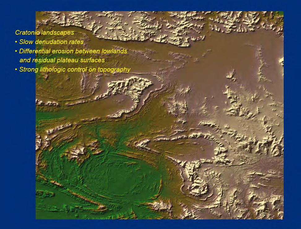
6 Weathering is Function of:! Bedrock! Climate - Biological activity! Relief! Time! Carajás, Amazon, Brazil Tom Price Western Australia

7 Bedrock! Channel! Erosion! Landsliding! And Rockfall! Diffusive! Hillslope! Transport! Bedrock! Weathering! Fluvial Erosion,! Transport, and! Deposition! Tectonic! Uplift! (Tucker and Slingerland, 1993)

8 Grotzinger et al., 2007!
9 Significance of Landscape Evolution Models to Supergene Ore Genesis?

10 Landscape Evolution Cycles: Implications to Mineral Exploration

11 How do we quantify supergene processes?! Climate Weathering Erosion Tectonics
12 Weathering geochronology H Shuster et al., GCA (2005) dh/dt=weathering rate Vasconcelos et al., GCA (1994) Vasconcelos (1999a,b) Carmo and Vasconcelos (2006)

13 Main stages of the 40 Ar/ 39 Ar method The 40 Ar/ 39 Ar dating method provides high analytical precision and accuracy, and high spatial resolution, as well as yield statistically confident data sets for the study of many geological processes.

14 Weathering geochronology by 40 Ar/ 39 Ar geochronology H Erosion Shuster et al., GCA (2005)


15 (U-Th/He) Goethite Dating Ken Farley Caltech P. Vasconcelos J. Heim Shuster et al Geoch. Cosmoch. Acta Heim et al Geology

16 Resolution: mm-size grains 600 ka to age of the earth Goethite Pisolith

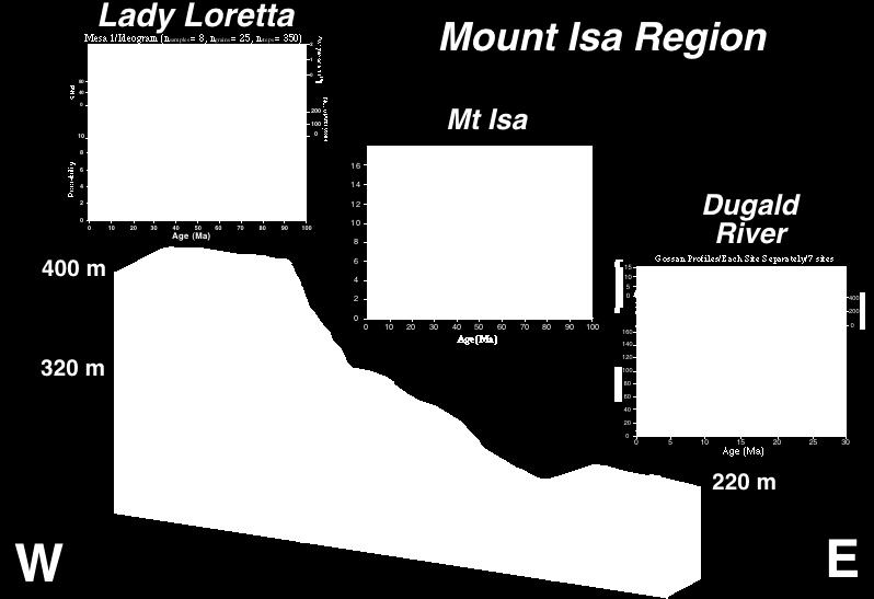
17 Study Sites in Australia


18 Dugald River, Mount Isa n samples = 35 n grains = 108 Vasconcelos and Conroy, GCA 2003


19 Vasconcelos and Conroy, 2003 Dugald River Interpretation Leads to the Same Hypothesis
20


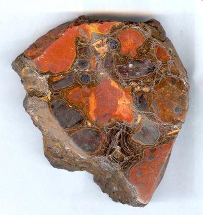
21 Cross-section of Yandi Channel Iron Deposit 505m Alluvium 495m Clay 480m 475m Upper CID 10m 35m BarimunyaMember 10 samples of iron locations oresample collected along a vertical traverse Sample locations Lower CID Munjina Member Weeli Wolli Fm. hmt hmt goe goe 1 cm hmt goe wood goe
 11.9 ± 0.4 Ma 10.0 ± 0.3 Ma Yan-02-08-4 Yan02-03 4.6 ± 0.")
, which greatly")
22 (U-Th)/He results of goethite (Apparent ages not corrected for helium diffusive loss) 11.9 ± 0.4 Ma 10.0 ± 0.3 Ma Yan Yan ± 0.1 Ma 5.8 ± 0.2 Ma 8.5 ± 0.3 Ma 7.1 ± 0.2 Ma 1 cm Yan02-04-A Analytical error ~ 3% (2σ), which greatly underestimates the error associated with helium diffusive loss


23 505m 10m 495m 35m (C) Schematic cross-section of Yandi Channel Iron Deposit (CID) Alluvium Clay 480m 475m 470m (D) Stratigraphic Column Alluvial deposits Oakover Fm- calcrete,silcrete Iowa Eastern mbr- clay Barimunya member Lower CID { Munjina mbr- clay, conglomerate Weeli Wolli Fm- BIF, shale, dolomite Present water table Sample locations Barimunya mbr- Upper/Lower CID Upper CID Munjina member Weeli Wolli Fm Marillana Ck. 10km 8.6, 10.3 Ma 10, 11.9 Ma 8.5, 7.2 Ma Ma ~9-14 Ma (A) Location Map (B) Yandi-Marillana Catchment Mine site 22 o 45 S 119 o 00 E Yandicoogina Ck.
24 Goethite age versus elevation graphs Yandi Channel Conclusions Ferruginization of channel sediments moves downwards Ferruginization occurs at the ground-water atmosphere interface y=2.72x R =0.62 y=1.17x R 2 =0.93 (D) Partial dissolution and re-precipitation of goethite in upper parts of the channel % helium loss Age (Ma) Heim et al., Geology, 2006

25 Study Sites
26 Carajas
 weathering profiles on")


27 Carajas 40Ar/39Ar Geochronology Deep (>100m) weathering profiles on plateaus Shallower (<30m) profiles on dissected plains Old to young weathering profiles on plateaus Young weathering profiles on dissected plains

28 70 Ma dh/dt = 6.89 m.ma m 12 Ma
29 SE Brazil

30 Carmo and Vasconcelos, ESPL, 2003 Carmo and Vasconcelos, ERPSL, 2005

31 Carmo & Vasconcelos, in prep.
 -20-40 -60-80 0 2 4 6 8 10 12 Plateau Age")
32 Weathered granite 0 m 0 y = x R= and 45 m 60 m Mn Oxides Depth (m) Plateau Age (Ma) Carmo and Vasconcelos, EPSL, 2006
33 Borborema
34 Borborema Study Maria da Guia Lima, PhD João Marinho Morais Neto, PhD 29 Sites sampled for 40Ar/39 Ar ~ 20 sites sample for goethite (U-Th)/he ~ 70 sites sample for 10Be ~ 15 sites sampled for feldspar 40Ar/39 Ar thermochronology > 50 sites sampled for AFFT and AHe Fonte: SRTM/USGS/EROS DATA CENTER
35 Weathering Profile Regional Distribution Vasconcelos (1999)

36 Weathering Geochronology Results, Borborema Province
37 Weathering Geochronology Results, Borborema Province old and young weathering profiles on Borborema Surface young weathering profiles only at Sertaneja Surface intermediate-age profiles at the Coastal Plateaus 800 Idade X Age x Elevation Elevação (m) Planalto da Borborema Depressão Sertaneja Planicies e Tabuleiros Costeiros Idade (Ma)
38 65 Ma Hamersley Australia Present Quadrilatero Ferrifero Brazil
39 Landscapes Have Ages! Hamersley Quadrilatero Ferrifero

40 How does the relative tempo of weathering and erosion controls supergene metal accumulation? Take home messages:! The weathering record is episodic;! Episodes at the Early Cenozoic correlate between Brazil and Australia;! Australian and Brazilian record strong weathering in the Miocene;! Weathering geochronology permits dating propagation of weathering! fronts through time;! Calculated weathering front propagation rates between Australia and! Brazil differ by a factor of two;! This difference is potentially related to the difference in climatic! histories between the two continents.
41 How to Quantify Erosion Rates? Weathering Climate Erosion Tectonics
42
43 Take Home Message! Old landscapes (Cretaceous) best but rare! Miocene Landscapes: significant weathering! and supergene enrichment.!

44 Take Home Message! Understand Miocene Landscapes!
A synopsis of the channel iron deposits of the Hamersley Province, Western Australia
 A synopsis of the channel iron deposits of the Hamersley Province, Western Australia E. R. Ramanaidou and R. C. Morris Erick Raymond Ramanaidou Minerals Down Under Flagship CSIRO ARRC PO Box 1130 Bentley
Page 1. Weathering & Erosion by Mass Wasting Pre-Test. Name:
 Weathering & Erosion by Mass Wasting Pre-Test 3048-1 - Page 1 Name: 1) As a particle of sediment in a stream breaks into several smaller pieces, the rate of weathering of the sediment will A) increase
Module 10: Resources and Virginia Geology Topic 4 Content: Virginia Geology Notes
 Virginia is composed of a very diverse landscape that extends from the beaches and barrier islands all of the way to the highly elevated Appalachian Plateau. Geologists have discovered ancient shallow
Supergene metal deposits host a comprehensive record of climate-driven
 The Paleoclimatic Signatures of Supergene Metal Deposits Paulo M. Vasconcelos 1, Martin Reich 2,3, and David L. Shuster 4,5 1811-5209/15/0011-0317$2.50 DOI: 10.2113/gselements.11.5.317 Supergene metal
WEATHERING-CONTROLLED FRACTIONATION OF ORE AND PATHFINDER ELEMENTS AT COBAR, NSW
 296 WEATHERING-CONTROLLED FRACTIONATION OF ORE AND PATHFINDER ELEMENTS AT COBAR, NSW Kenneth G. McQueen 1,2 & Dougal C. Munro 1 1 CRC LEME, Department of Geology, Australian National University, ACT, 0200
Weathering, Erosion, Deposition, and Landscape Development
 Weathering, Erosion, Deposition, and Landscape Development I. Weathering - the breakdown of rocks into smaller particles, also called sediments, by natural processes. Weathering is further divided into
Understanding Earth Fifth Edition
 Understanding Earth Fifth Edition Grotzinger Jordan Press Siever Chapter 16: WEATHERING, EROSION, AND MASS WASTING Interface Between Climate and Tectonics Lecturer: H Mohammadzadeh Assistant professors,
Project Document. BASE - Basement fracturing and weathering on- and offshore Norway Genesis, age, and landscape development
 Project Document BASE - Basement fracturing and weathering on- and offshore Norway Genesis, age, and landscape development Partners: Geological Survey of Norway (NGU), SINTEF Petroleum Research (SINTEF)
Continental Landscapes
 Continental Landscapes Landscape influenced by tectonics, climate & differential weathering Most landforms developed within the last 2 million years System moves toward an equilibrium Continental Landscapes
Mineral Systems modelling in the Mount Isa Inlier, and its use in identification of permissive tracts for copper and lead/zinc mineralisation.
 Department of Natural Resources and Mines Mineral Systems modelling in the Mount Isa Inlier, and its use in identification of permissive tracts for copper and lead/zinc mineralisation. L.J.Hutton Geological
A study of the variation in the Rooikoppie gravels in the Lower Vaal area
 A study of the variation in the Rooikoppie gravels in the Lower Vaal area A study of the variation in the Rooikoppie gravels in the Lower Vaal area M. Ndwammbi Rockwell Diamonds Inc The Rooikoppie gravel
Zeumann and Hampel, 2017, Impact of Cocos Ridge (Central America) subduction on the forearc drainage system: Geology, doi: /g
 subduction on the forearc drainage system: Geology, doi: /g") GSA Data Repository 2017296 Zeumann and Hampel, 2017, Impact of Cocos Ridge (Central America) subduction on the forearc drainage system: Geology, doi:10.1130/g39251.1. DESCRIPTION OF CASQUS To implement
GSA Data Repository 2017296 Zeumann and Hampel, 2017, Impact of Cocos Ridge (Central America) subduction on the forearc drainage system: Geology, doi:10.1130/g39251.1. DESCRIPTION OF CASQUS To implement
INTRODUCTION. Climate
 INTRODUCTION Climate Landslides are serious natural disasters in many parts of the world. Since the past 30 years, rainfall triggered landslides and debris flows had been one of the natural disasters of
Uniformitarian Speculations on Gravel Transport East
 Chapter 15 Uniformitarian Speculations on Gravel Transport East Chapter 14 presented evidence that quartzites were transported up to 800 miles (1,280 km) northeast from their source in the western Rocky
mountain rivers fixed channel boundaries (bedrock banks and bed) high transport capacity low storage input output
 high transport capacity low storage input output") mountain rivers fixed channel boundaries (bedrock banks and bed) high transport capacity low storage input output strong interaction between streams & hillslopes Sediment Budgets for Mountain Rivers Little
mountain rivers fixed channel boundaries (bedrock banks and bed) high transport capacity low storage input output strong interaction between streams & hillslopes Sediment Budgets for Mountain Rivers Little
Down-stream process transition (f (q s ) = 1)
 = 1)") Down-stream process transition (f (q s ) = 1) Detachment Limited S d >> S t Transport Limited Channel Gradient (m/m) 10-1 Stochastic Variation { Detachment Limited Equilibrium Slope S d = k sd A -θ d S
Down-stream process transition (f (q s ) = 1) Detachment Limited S d >> S t Transport Limited Channel Gradient (m/m) 10-1 Stochastic Variation { Detachment Limited Equilibrium Slope S d = k sd A -θ d S
Soil Formation. Parent Material. Time. Climate
 Soil Formation Parent Material Time Climate Topography Biota Main Objectives 1. Gain a general understanding of soil formation processes 2. Understand the importance of mineral weathering in soil formation
UNRAVELING THE HISTORY OF A LANDSCAPE: Using geomorphology, tephrochronology, and stratigraphy. Photo by: Josh Roering
 UNRAVELING THE HISTORY OF A LANDSCAPE: Using geomorphology, tephrochronology, and stratigraphy Photo by: Josh Roering Photo: Eric Bilderback Photo by: Josh Roering Goal 1. Reconstruct the paleo-landscape
Sediment and Sedimentary rock
 Sediment and Sedimentary rock Sediment: An accumulation of loose mineral grains, such as boulders, pebbles, sand, silt or mud, which are not cemented together. Mechanical and chemical weathering produces
Effects of transient topography and drainage basin evolution on detrital thermochronometer data
 UNIVERSITY OF MICHIGAN Effects of transient topography and drainage basin evolution on detrital thermochronometer data Contents Acknowledgments...3 Abstract...4 1. Introduction...5 2. Model setup...6 2.1
Source- to- Sink in the Stra/graphic Record
 Source- to- Sink in the Stra/graphic Record Capturing the Long-Term, Deep-Time Evolution of Sedimentary Systems Stephan A. Graham Stanford University Brian W. Romans Chevron Energy Technology Co. Jacob
PALEOGEOGRAPHY of NYS. Definitions GEOLOGIC PROCESSES. Faulting. Folding 9/6/2012. TOPOGRAPHIC RELIEF MAP of NYS GRADATIONAL TECTONIC
 TOPOGRAPHIC RELIEF MAP of NYS PALEOGEOGRAPHY of NYS Prof. Anthony Grande AFG 2012 Definitions GEOLOGIC PROCESSES Geography: study of people living on the surface of the earth. Geology: the scientific study
Topic 6: Weathering, Erosion and Erosional-Deposition Systems (workbook p ) Workbook Chapter 4, 5 WEATHERING
 Workbook Chapter 4, 5 WEATHERING") Topic 6: Weathering, Erosion and Erosional-Deposition Systems (workbook p. 95-125) Workbook Chapter 4, 5 THE BIG PICTURE: Weathering, erosion and deposition are processes that cause changes to rock material
Topic 6: Weathering, Erosion and Erosional-Deposition Systems (workbook p. 95-125) Workbook Chapter 4, 5 THE BIG PICTURE: Weathering, erosion and deposition are processes that cause changes to rock material
GEOLOGY MEDIA SUITE Chapter 5
 UNDERSTANDING EARTH, SIXTH EDITION GROTZINGER JORDAN GEOLOGY MEDIA SUITE Chapter 5 Sedimentation Rocks Formed by Surface Processes 2010 W.H. Freeman and Company Mineralogy of sandstones Key Figure 5.12
Sediments and. Sedimentary Rocks
 Sediments and Sedimentary Rocks Bottom Line Sedimentary rocks form from particles accumulated in sedimentary layers Sedimentary layers can be formed by clastic or detrital particles (e.g., sand grains,
Geochemical exploration in regolithdominated terrains global perspective. Ravi Anand May 2014
 Geochemical exploration in regolithdominated terrains global perspective Ravi Anand May 2014 Acknowledgements Numerous mining companies CSIRO/CRC LEME/MDU AMIRA Why regolith research for mineral exploration
Practice Test Rocks and Minerals. Name. Page 1
 Name Practice Test Rocks and Minerals 1. Which rock would be the best source of the mineral garnet? A) basalt B) limestone C) schist D) slate 2. Which mineral is mined for its iron content? A) hematite
Clastic Sedimentary Rocks
 Clastic Sedimentary Rocks Alessandro Grippo, Ph.D. Alternating sandstones and mudstones in Miocene turbidites Camaggiore di Firenzuola, Firenze, Italy Alessandro Grippo review Mechanical weathering creates
Rockall Plateau. OCN 201: Shelf Sediments
 Rockall Plateau OCN 201: Shelf Sediments Classification by Size Classification by Mode of Formation Detrital sediments Transported and deposited as particles Derived from weathering of pre-existing rocks
GEOLOGY, GEOCHEMISTRY AND EXPLORATION OF MINERAL DEPOSITS IN DEEPLY WEATHERED TERRAINS. Estela Nascimento & John Barr
 GEOLOGY, GEOCHEMISTRY AND EXPLORATION OF MINERAL DEPOSITS IN DEEPLY WEATHERED TERRAINS Estela Nascimento & John Barr SIMEXMIN BRAZIL, MAY 2014 OVERVIEW Geology & Geochemistry of Mineralization in Areas
GD3.3/GM3.3/GMPV16/TS4.7
 GM Geomorphology Orals and PICOs MO1, 08:30 10:00 MO2, 10:30 12:00 MO3, 13:30 15:00 MO4, 15:30 17:00 MO5, 17:30 19:00 TU1, 08:30 10:00 TU2, 10:30 12:00 TUL, 12:15 13:15 TU3, 13:30 15:00 Monday, 08 April
Determination of uplift rates of fluvial terraces across the Siwaliks Hills, Himalayas of central Nepal
 Determination of uplift rates of fluvial terraces across the Siwaliks Hills, Himalayas of central Nepal Martina Böhme Institute of Geology, University of Mining and Technology, Freiberg, Germany Abstract.
Earth and Planetary Science Letters
 Earth and Planetary Science Letters 329-33 (212) 41 5 Contents lists available at SciVerse ScienceDirect Earth and Planetary Science Letters journal homepage: www.elsevier.com/locate/epsl Cosmogenic 3
14. Weathering and Regolith
 The Australian Continent: A Geophysical Synthesis Weathering and Regolith 123 14. Weathering and Regolith The regolith consists of the zone at the Earth's surface between fresh rock and the interface with
Name Class Date. 1. In your own words, write a definition for the term rock cycle.
 Skills Worksheet Chapter Review USING KEY TERMS 1. In your own words, write a definition for the term rock cycle. Complete each of the following sentences by choosing the correct term from the word bank.
GLG101: What-To-Know List
 Exam 3, Page 1 GLG101: What-To-Know List (Derived from Before You Leave This Page Lists) This list is intended to guide your reading and to help you prepare for the online multiple-choice quizzes. Each
Sedimentary Rocks. Origin, Properties and Identification. Physical Geology GEOL 101 Lab Ray Rector - Instructor
 Sedimentary Rocks Origin, Properties and Identification Physical Geology GEOL 101 Lab Ray Rector - Instructor Sedimentary Rock Origin and Identification Lab Pre-Lab Internet Link Resources 1) http://www.rockhounds.com/rockshop/rockkey/index.html
Beneath the sand of the Tanami Desert
 Beneath the sand of the Tanami Desert ARGA 2018, Wallaroo, SA Nadir de Souza Kovacs Ngururrpa program The program area covers the traditional land of the Parna Ngururrpa People in a remote part of the
As compaction and cementation of these sediments eventually occur, which area will become siltstone? A) A B) B C) C D) D
 A B) B C) C D) D") 1. A student obtains a cup of quartz sand from a beach. A saltwater solution is poured into the sand and allowed to evaporate. The mineral residue from the saltwater solution cements the sand grains together,
1. A student obtains a cup of quartz sand from a beach. A saltwater solution is poured into the sand and allowed to evaporate. The mineral residue from the saltwater solution cements the sand grains together,
Lecture 29: Soil Formation
 Lecture 29: Soil Formation Factors Controlling Soil Formation 1. Parent material: Soil precursor 2. Climate: Temperature and precipitation 3. Biota: Native vegetation, microbes, soil animals, humans 4.
Ch 10 Deposition Practice Questions
 1. Base your answer to the following question on the data table below. Six identical cylinders, A through F, were filled with equal volumes of sorted spherical particles. The data table shows the particle
REGOLITH GEOCHEMISTRY OF THE NORTH KIMBERLEY, WESTERN AUSTRALIA: A STRONG PROXY FOR BEDROCK
 REGOLITH GEOCHEMISTRY OF THE NORTH KIMBERLEY, WESTERN AUSTRALIA: A STRONG PROXY FOR BEDROCK Paul A. Morris 1 1 Geological Survey of Western Australia, 100 Plain Street, East Perth 6004, Western Australia;
Ecoregions Glossary. 7.8B: Changes To Texas Land Earth and Space
 Ecoregions Glossary Ecoregions The term ecoregions was developed by combining the terms ecology and region. Ecology is the study of the interrelationship of organisms and their environments. The term,
10 BILLION TONNES TOTAL RESOURCES ACHIEVED FROM MAJOR MAIDEN RESOURCE ESTIMATE FOR WESTERN HUB
 23 March 2011 The Companies Officer ASX Limited 2 The Esplanade Perth WA 6000 Dear Sir 10 BILLION TONNES TOTAL RESOURCES ACHIEVED FROM MAJOR MAIDEN RESOURCE ESTIMATE FOR WESTERN HUB A substantial increase
Locating the Flood/post-Flood boundary using the relative dating of the weathering of ore deposits
 The Proceedings of the International Conference on Creationism Volume 8 Article 46 2018 Locating the Flood/post-Flood boundary using the relative dating of the weathering of ore deposits DOI: https://doi.org/10.15385/jpicc.2018.8.1.40
Sedimentary Rocks. Origin, Properties and Identification. Geology Laboratory GEOL 101 Lab Ray Rector - Instructor
 Sedimentary Rocks Origin, Properties and Identification Geology Laboratory GEOL 101 Lab Ray Rector - Instructor Sedimentary Rock Origin and Identification Lab Pre-Lab Internet Link Resources 1) http://www.rockhounds.com/rockshop/rockkey/index.html
Glaciers. 1. The photograph below shows the results of a landslide.
 Name: Date: 1. The photograph below shows the results of a landslide. This landslide is an example of A) wind abrasion B) glacial deposition C) wave action D) mass movement 2. Which agent of erosion is
Beckenanalyse 2. Genetische stratigraphische Konzepte
 Beckenanalyse 2. Genetische stratigraphische Konzepte Einsele 2000 CYCLIC BEDDING Einsele 2000 1 Sequenzstratigraphie Das Konzept der Sequenzstratigraphie beruht auf dem Zusammenspiel von Sedimentzufuhr
Landscape evolution. An Anthropic landscape is the landscape modified by humans for their activities and life
 Landforms Landscape evolution A Natural landscape is the original landscape that exists before it is acted upon by human culture. An Anthropic landscape is the landscape modified by humans for their activities
Quiz 1. 3) Which of the following planetary bodies has the least number of impact craters on its surface? A) Mercury B) Mars C) the Moon D) Earth
 Which of the following planetary bodies has the least number of impact craters on its surface? A) Mercury B) Mars C) the Moon D) Earth") Quiz 1 1) Earth's atmosphere is unique among the moons and planets in that A) it has a nitrogen (N2) rich atmosphere. B) it is rich in oxygen (O2) and nitrogen (N2). C) it is rich in carbon dioxide because
Quiz 1 1) Earth's atmosphere is unique among the moons and planets in that A) it has a nitrogen (N2) rich atmosphere. B) it is rich in oxygen (O2) and nitrogen (N2). C) it is rich in carbon dioxide because
Sediment and sedimentary rocks Sediment
 Sediment and sedimentary rocks Sediment From sediments to sedimentary rocks (transportation, deposition, preservation and lithification) Types of sedimentary rocks (clastic, chemical and organic) Sedimentary
What landforms make up Australia?!
 What landforms make up Australia? The tectonic forces of folding, faulting and volcanic activity have created many of Australia's major landforms. Other forces that work on the surface of Australia, and
Bryce Canyon. Bryce Zion
 Bryce Canyon Located ~50 mi NE of Zion in southern Utah On Paunsaugunt Plateau: Wetter and Colder than Zion Bounded by Sevier Fault to west and Paunsaugunt Fault to east Rocks are ~100 Ma older than at
Lab 7: Sedimentary Structures
 Name: Lab 7: Sedimentary Structures Sedimentary rocks account for a negligibly small fraction of Earth s mass, yet they are commonly encountered because the processes that form them are ubiquitous in the
Objectives. Introduction to Soils. Terms to know: What is soil? Study of Soils. The Soil Body 11/9/2012
 Objectives Explain what soil is and where it comes from Define a soil body List examples of the five soil-forming factors Explain how soils develop Introduction to Soils Terms to know: What is soil? Alluvial
LANDFORMS of NYS. Landforms. Exercise 4 9/13/2012. TOPOGRAPHIC RELIEF MAP of NYS. Physiographic map of NYS and vicinity showing Surface Features
 TOPOGRAPHIC RELIEF MAP of NYS LANDFORMS of NYS Prof. Anthony Grande AFG 2012 Landforms REMINDER: The basis of present-day landforms (surface features) is the bedrock geology that has been worked on by
Laboratory Exercise #4 Geologic Surface Processes in Dry Lands
 Page - 1 Laboratory Exercise #4 Geologic Surface Processes in Dry Lands Section A Overview of Lands with Dry Climates The definition of a dry climate is tied to an understanding of the hydrologic cycle
Implications of AEM for uranium in the Paterson area
 Implications of AEM for uranium in the Paterson area Songfa Liu, Subhash Jaireth, David Huston, Ian Roach Onshore Energy and Minerals Division, Geoscience Australia GPO Box 378, Canberra ACT 2601 Outline
A Regional Diagenetic and Petrophysical Model for the Montney Formation, Western Canada Sedimentary Basin*
 A Regional Diagenetic and Petrophysical Model for the Montney Formation, Western Canada Sedimentary Basin* Noga Vaisblat 1, Nicholas B. Harris 1, Vincent Crombez 2, Tristan Euzen 3, Marta Gasparrini 2,
Weathering geochronology by (U-Th)/He dating of goethite
/He dating of goethite") doi:10.1016/j.gca.2004.07.028 Geochimica et Cosmochimica Acta, Vol. 69, No. 3, pp. 659 673, 2005 Copyright 2005 Elsevier Ltd Printed in the USA. All rights reserved 0016-7037/05 $30.00.00 Weathering geochronology
doi:10.1016/j.gca.2004.07.028 Geochimica et Cosmochimica Acta, Vol. 69, No. 3, pp. 659 673, 2005 Copyright 2005 Elsevier Ltd Printed in the USA. All rights reserved 0016-7037/05 $30.00.00 Weathering geochronology
12. The diagram below shows the collision of an oceanic plate and a continental plate.
 Review 1. Base your answer to the following question on the cross section below, which shows the boundary between two lithospheric plates. Point X is a location in the continental lithosphere. The depth
Sedimentary Environments Chapter 8
 Sedimentary Environments Chapter 8 Does not contain complete lecture notes. To be used to help organize lecture notes and home/test studies. What is a sedimentary rock? Sedimentary rocks are products of
Sedimentary Basins. Gerhard Einsele. Springer-Verlag Berlin Heidelberg New York London Paris Tokyo Hong Kong Barcelona Budapest
 Gerhard Einsele Sedimentary Basins Evolution, Facies, and Sediment Budget With 269 Figures Springer-Verlag Berlin Heidelberg New York London Paris Tokyo Hong Kong Barcelona Budapest Contents Part I Types
Geology (Mellow) Hike, Santa Lucia Memorial Park February 16, I. Overview of Santa Lucia Range geology and tectonic history
 Hike, Santa Lucia Memorial Park February 16, I. Overview of Santa Lucia Range geology and tectonic history") Geology (Mellow) Hike, Santa Lucia Memorial Park February 16, 2015 I. Overview of Santa Lucia Range geology and tectonic history A. Basement Rocks 1. Salinian Block Rocks Sierra Nevada Type, continental
Geology (Mellow) Hike, Santa Lucia Memorial Park February 16, 2015 I. Overview of Santa Lucia Range geology and tectonic history A. Basement Rocks 1. Salinian Block Rocks Sierra Nevada Type, continental
Section I: Multiple Choice Select the best answer to each question. Mark your final answer on the answer sheet. (1 pt each)
") Sedimentary Rocks & Surface Processes Quest Name: Earth Science 2013 Block: Date: Section I: Multiple Choice Select the best answer to each question. Mark your final answer on the answer sheet. (1 pt each)
Sedimentary Rocks & Surface Processes Quest Name: Earth Science 2013 Block: Date: Section I: Multiple Choice Select the best answer to each question. Mark your final answer on the answer sheet. (1 pt each)
Sedimentary Rocks. Origin, Properties and Identification. Physical Geology GEOL 100. Ray Rector - Instructor
 Sedimentary Rocks Origin, Properties and Identification Physical Geology GEOL 100 Ray Rector - Instructor Sedimentary Rock Origin and Identification Lab Pre-Lab Internet Link Resources 1) http://www.rockhounds.com/rockshop/rockkey/index.html
HW #2 Landscape Travel from A to B 12,
 HW #2 Landscape 2016 Section: Name: ate: 1. ase your answer(s) to the following question(s) on the map below, which represents two bridges that cross the Green River. Letters,, and represent locations
Chapter 3. Geology & Tectonics
 Chapter 3 Geology & Tectonics 3.1 Geology The general geological features of Indonesia are shown in Figure 3.1. The basement formation is metamorphic and it is intruded with plutonic formations. They are
Terrain Units PALEOGEOGRAPHY: LANDFORM CREATION. Present Geology of NYS. Detailed Geologic Map of NYS
 NYS TOPOGRAPHY Why so? PALEOGEOGRAPHY: LANDFORM CREATION Prof. Anthony Grande AFG 014 Present Geology of NYS Detailed Geologic Map of NYS Generalized Geology Detailed Geology Hot links to the fold out
Chemolithoautotrophs: Archaea
 Chemolithoautotrophs: Archaea These critters figured out how to do something incredible. they began taking CO 2 out of the air, and using it to make sugars. The byproduct was OXYGEN. Stage 7: Paleoproterozoic
Earth Systems Science Chapter 7. Earth Systems Science Chapter 7 11/11/2010. Seismology: study of earthquakes and related phenomena
 Earth Systems Science Chapter 7 I. Structure of the Earth II. Plate Tectonics The solid part of the earth system includes processes, just like the atmosphere and oceans. However, the time scales for processes
TOPOGRAPHIC RELIEF MAP of NYS. LANDFORMS of NYS. Landforms. Creation of NYS Landforms 9/22/2011
 TOPOGRAPHIC RELIEF MAP of NYS LANDFORMS of NYS Prof. Anthony Grande AFG 2011 Landforms The basis of present-day landforms (surface features) is the bedrock geology that has been worked on by the forces
Announcements. First problem set due next Tuesday. Review for first exam next Thursday. Quiz on Booth (1994) after break today.
 after break today.") Announcements First problem set due next Tuesday. Review for first exam next Thursday. Quiz on Booth (1994) after break today. Intertidal, Lowes Cove, ME Marine Sediments: Clues to the ocean s past There
Announcements First problem set due next Tuesday. Review for first exam next Thursday. Quiz on Booth (1994) after break today. Intertidal, Lowes Cove, ME Marine Sediments: Clues to the ocean s past There
Sedimentology & Stratigraphy. Thanks to Rob Viens for slides
 Sedimentology & Stratigraphy Thanks to Rob Viens for slides Sedimentology The study of the processes that erode, transport and deposit sediments Sedimentary Petrology The study of the characteristics and
C) use of nuclear power D) number of volcanic eruptions
 use of nuclear power D) number of volcanic eruptions") 3121-1 - Page 1 Name: 1) The graph below shows the change in carbon dioxide concentration in parts per million (ppm) in Earth's atmosphere from 1960 to 1990. The most likely cause of the overall change
3121-1 - Page 1 Name: 1) The graph below shows the change in carbon dioxide concentration in parts per million (ppm) in Earth's atmosphere from 1960 to 1990. The most likely cause of the overall change
6. Relative and Absolute Dating
 6. Relative and Absolute Dating Adapted by Sean W. Lacey & Joyce M. McBeth (2018) University of Saskatchewan from Deline B, Harris R, & Tefend K. (2015) "Laboratory Manual for Introductory Geology". First
Fossil Clues Teacher s Notes
 Fossils are the remains of living things which have been changed into rock. The father of modern geology, James Hutton, said that we can interpret the nature of creatures from the past and the environment
Name: Which rock layers appear to be most resistant to weathering? A) A, C, and E B) B and D
 A, C, and E B) B and D") Name: 1) The formation of soil is primarily the result of A) stream deposition and runoff B) precipitation and wind erosion C) stream erosion and mass movement D) weathering and biological activity 2)
Name: 1) The formation of soil is primarily the result of A) stream deposition and runoff B) precipitation and wind erosion C) stream erosion and mass movement D) weathering and biological activity 2)
 Tutors: Huw Williams & Paul Davies (Reservoir Geology Consultants Limited) Duration: A six day field and classroom-based reservoir geology and modelling course in Grand Junction, Colorado and Green River,
Figure 1 The map shows the top view of a meandering stream as it enters a lake. At which points along the stream are erosion and deposition dominant?
 1. In which type of climate does chemical weathering usually occur most rapidly? 1. hot and dry 3. cold and dry 2. hot and wet 4. cold and wet 2. Figure 1 The map shows the top view of a meandering stream
Classification according to patent rock material/origin, soil distribution and orders
 Classification according to patent rock material/origin, soil distribution and orders Alluvial Soils Shales and Sandstone Soils Limestone Soils Chocolate Hills: Limestone formation Andesite and Basalt
RELIANCE, FLINDERS RANGES: MINERALOGY, GEOCHEMISTRY AND ZINC DISPERSION AROUND A NONSULFIDE OREBODY
 86 RELIANCE, FLINDERS RANGES: MINERALOGY, GEOCHEMISTRY AND ZINC DISPERSION AROUND A NONSULFIDE OREBODY Nathan Emselle 1, D.C. McPhail 1 & S.A. Welch 1,2 1 CRC LEME, Department of Earth and Marine Sciences,
Geography Class XI Fundamentals of Physical Geography Section A Total Periods : 140 Total Marks : 70. Periods Topic Subject Matter Geographical Skills
 Geography Class XI Fundamentals of Physical Geography Section A Total Periods : 140 Total Marks : 70 Sr. No. 01 Periods Topic Subject Matter Geographical Skills Nature and Scope Definition, nature, i)
FAILURES IN THE AMAZON RIVERBANKS, IQUITOS, PERU
 FAILURES IN THE AMAZON RIVERBANKS, IQUITOS, PERU A.Carrillo-Gil University of Engineering & A.Carrillo Gil S.A.,Consulting Engineering,Lima,Peru L. Dominguez University of Engineering,Lima & The Maritime
Geology 101. Reading Guides for Chapters 6 and 12
 Geology 101 Name Chapter 6: Weathering and Soils (p. 160): Reading Guides for Chapters 6 and 12 This chapter is about the processes involved in the disintegration of rock. Weathering is often mistaken
Global phosphorus cycle
 Global phosphorus cycle OCN 623 Chemical Oceanography 11 April 2013 2013 Arisa Okazaki and Kathleen Ruttenberg Outline 1. Introduction on global phosphorus (P) cycle 2. Terrestrial environment 3. Atmospheric
THEME 6: The Transvaal Supergroup
 THEME 6: The Transvaal Supergroup The Ventersdorp Supergroup represents rifting of the Kaapvaal Craton. However the craton did not break-up, and after a period of stability, renewed stretching and rifting
Preliminaries to Erosion: Weathering and Mass Wasting
 Preliminaries to Erosion: Weathering & Mass Wasting All things deteriorate in time. Virgil 1 Preliminaries to Erosion: Weathering and Mass Wasting Denudation The Impact of Weathering and Mass Wasting on
THRESHOLD LIMIT VALUES FOR HEAVY METALS IN SOILS IN THE FUNCTION OF SPATIAL AND TEMPORAL VARIATION OF GEOCHEMICAL FACTORS. P. SIPOS and T.
 THRESHOLD LIMIT VALUES FOR HEAVY METALS IN SOILS IN THE FUNCTION OF SPATIAL AND TEMPORAL VARIATION OF GEOCHEMICAL FACTORS P. SIPOS and T. PÓKA Laboratory for Geochemical Research, Hungarian Academy of
Chapter 3 Sedimentation of clay minerals
 Chapter 3 Sedimentation of clay minerals 3.1 Clay sedimentation on land 3.2 From land to sea 3.3 Clay sedimentation in the sea 1 3.1 Clay sedimentation on land Deserts Glaciers Rivers Lacustrine 2 University
Understanding Earth Fifth Edition
 Understanding Earth Fifth Edition Grotzinger Jordan Press Siever Chapter 5: SEDIMENTATION: Rocks Formed by Surface Processes Lecturer: H Mohammadzadeh Assistant professors, Department of Geology, FUM Copyright
Mineral Resource for Pilbara Iron Ore Project increased to more than 900 Mt Pilbara Iron Ore Project (PIOP), Western Australia
, Western Australia") ASX ANNOUNCEMENT 14 November 2011 Mineral Resource for Pilbara Iron Ore Project increased to more than 900 Mt Pilbara Iron Ore Project (PIOP), Western Australia highlights Further 23% increase to 917 Mt
ASX ANNOUNCEMENT 14 November 2011 Mineral Resource for Pilbara Iron Ore Project increased to more than 900 Mt Pilbara Iron Ore Project (PIOP), Western Australia highlights Further 23% increase to 917 Mt
Weathering Erosion and Deposition. Presented by Kesler Science
 Weathering Erosion and Deposition Presented by Kesler Science Essential Questions: 1. What effects do weathering, erosion, and deposition have on the environment in ecoregions? Weathering Chemical and
TAKE HOME EXAM 8R - Geology
 Name Period Date TAKE HOME EXAM 8R - Geology PART 1 - Multiple Choice 1. A volcanic cone made up of alternating layers of lava and rock particles is a cone. a. cinder b. lava c. shield d. composite 2.
Weathering, Erosion, Deposition
 Weathering, Erosion, Deposition The breakdown of rocks at or near the Earth s Surface. Physical Chemical - The breakdown of rock into smaller pieces without chemical change. - Dominant in moist /cold conditions
Earth s Structure and Surface
 Earth s Structure and Surface Structure of the Earth The earth is thought have originated about 4.5 billion years ago from a cloud or clouds of dust. The dust was the remains of a huge cosmic explosion
Chapter 4 Implications of paleoceanography and paleoclimate
 Age ka / Chapter 4 Implications of paleoceanography and paleoclimate 4.1 Paleoclimate expression 4.2 Implications of paleocirculation and tectonics 4.3 Paleoenvironmental reconstruction MD05-2901 (Liu
Section 11.1 pp Where Mountains Form
 Section 11.1 pp. 236 237 Where Mountains Form Chapter 11 Set a Purpose: TE, p. 236 Reading Study Guide, p. 36 Discussion: TE, p. 236 Differentiating ion Reading Support: TE, p. 236 Visual Teaching Interpret
State Metallic Minerals Lease Sale Minnesota s Vermilion Gold District
 State Metallic Minerals Lease Sale Minnesota s Vermilion Gold District State Metallic Minerals Lease Sale Notice of Intent Scale 1:100,000 State Metallic Minerals Lease Sale This portion of the lease sale
3. Radiometry. The Australian Continent: A Geophysical Synthesis Radiometry
 16 3. Radiometry A major effort has been made to assemble a continent-scale study combining the results of many different airborne radiometric surveys (Figure 3.1). The radiometric surveys measure the