Analysis of Ground Penetrating Radar s Capability for Detecting Underground Cavities: A Case Study in Japan Cave of Taman Hutan Raya, Bandung
|
|
|
- Shawn Barker
- 6 years ago
- Views:
Transcription
1 IOP Conference Series: Earth and Environmental Science PAPER OPEN ACCESS Analysis of Ground Penetrating Radar s Capability for Detecting Underground Cavities: A Case Study in Japan Cave of Taman Hutan Raya, Bandung To cite this article: Azizatun Azimmah and Widodo 2017 IOP Conf. Ser.: Earth Environ. Sci Related content - GPR application on construction foundation study T S T Amran, M P Ismail, M A Ismail et al. - The land-use of Bandung, its density, overcrowded area and public facility toward a compact city B Paramita - Signal processing technology and its application research of ground penetrating radar (GPR) Wanshun Wang, Lisheng Hao, Xiuwen Li et al. View the article online for updates and enhancements. This content was downloaded from IP address on 13/01/2018 at 08:16
2 Analysis of Ground Penetrating Radar s Capability for Detecting Underground Cavities: A Case Study in Japan Cave of Taman Hutan Raya, Bandung Azizatun Azimmah 1, Widodo 2 1 Undergraduate Program of Geophysical Engineering, Institut Teknologi Bandung, Indonesia 2 Applied Geophysics and Exploration Research Group, Faculty of Mining and Petroleum Engineering, Institut Teknologi Bandung, Indonesia azizatunazimmah@gmail.com Abstract. Underground cavities or voids detection is essential especially when it comes to building construction. By knowing the presence of void lying underground, one could consider whether the subsidence is likely to be prevented or not. Ground penetrating radar is a highfrequency electromagnetic sounding technique that has been developed to investigate the shallow subsurface using the contrast of dielectric properties. This geophysical method is suitable to be used to detect and locate voids beneath the surface especially those that lie in shallow depth. This research focused on how GPR could be implemented as void detector using model simulation or forward modelling. The models applied in the forward modelling process are to be made as similar as the real condition in the case study location which took place in Tahura Japan Cave, Bandung, Indonesia. Forward modelling needs to be done so in the future, we might use the modelling results as the references in measuring real GPR data in the location. We used three models that we considered fairly representative to prove that GPR is capable of detecting and locating voids underneath the ground. This research resulted in the different amplitude region around the considerably homogeneous region. The different amplitude region is characterized having an arc shape and is considered to be air which is known as the key component of voids. 1. Introduction Underground voids could happen naturally as well as artificially like underground mining, tunnel and also cavities. Voids detection holds an important role in urban planning and construction. In such projects, especially those in the civil engineering field, it is necessary to identify every single void which lies underneath the construction site because it would bring unwanted effects such as subsidence and even total collapse to the ground surface [1][2]. Some geophysical methods commonly applied for detecting underground voids are GPR, seismic, gravity and also electrical measurement [3][4]. Ground Penetrating Radar (GPR) is one of non-destructive geophysical method most recommended to be used in studying shallow subsurface imaging [5]. GPR method has been used for many purposes due to its effectiveness in mapping the shallow depth subsurface including its application for detecting human buried body [6]. Its data sensitivity to dielectric permittivity variation make GPR method could be Content from this work may be used under the terms of the Creative Commons Attribution 3.0 licence. Any further distribution of this work must maintain attribution to the author(s) and the title of the work, journal citation and DOI. Published under licence by Ltd 1
, for the reflection caused by the interface between soil-air and air-soil could be easily identified.")
3 Southeast Asian Conference on Geophysics IOP Conf. Series: Earth and Environmental Science (2017) doi: / /62/1/ applied to detect any void (natural or anthropogenic), for the reflection caused by the interface between soil-air and air-soil could be easily identified. This research aims to prove that GPR could be applied to detect underground voids by imaging subsurface structure where its voids positions have already been known. Hence, we chose Goa Jepang Taman Hutan Raya (Japan Cave of Tahura) as the area of the investigation. 2. Method 2.1. Ground Penetrating Radar in Void detection GPR works by transmitting EM waves as a source that penetrates medias beneath the site of investigation. Any reflected wave caused by material interfaces in the subsurface is then detected by receiver antenna. When a propagating electromagnetic wave encounters a discontinuity in electric, magnetic or conductive properties, part of the electromagnetic energy is reflected, and the reflection strength being proportional to the magnitude of change. For a perpendicular incident wave, the strength of a GPR reflection is a function of the contrast in relative dielectric constants across the reflecting boundary, and the reflection coefficient RC can be expressed as [7]: (1) = + Where εr1 represents relative dielectric constant of upper soil horizon and εr2 represents the relative dielectric constant of lower soil horizon. Another research executed by Kofman et al. [8] that aims to examine the relationship between voids dimensions and wavelengths of various antennas, and the corresponding GPR responses, shows that there were strong reverberations generated by the inner surface of the void targets [9] Geological Setting The models, applied in forward modelling or numerical simulation, were constructed to be as similar as the geological setting had by the site of investigation. Japan Cave Taman Hutan Raya is in Dago Pakar, Bandung, Indonesia and geographically located in latitude 6 51' '' S and longitude ' ''E. Figure 1. Geology map of Dago (Silitonga, 1979) 2
4 Southeast Asian Conference on Geophysics IOP Conf. Series: Earth and Environmental Science (2017) doi: / /62/1/ Type of the rocks dominated in Dago Pakar belongs to the group of sandy tuff originated in Dano mountain and Tangkuban Perahu volcano, according to regional geology map published by Silitonga in 1979 [10] (Figure 1). The map indicated that the type of rocks in Dago Pakar belongs to Qyd formation which consists of sandy tuff sourced by Dano and tangkuban Perahu volcano. The brown sandy tuff contains coarse and hollow hornblende mineral crystal and it has glassy luster and also resembles reddish lava, lapilli layers and breccia [11]. The material that forms the cave wall is merely hard rock without being layered by cement-concrete. Based on regional geology map, this hard rock is considered to be tuff that resembles the rock formed in Dago Pakar and it is likely to be emanated from the eruption of Tangkuban Perahu Volcano [12]. Figure 2. Pyroclastic tuff rock as the rock forming the cave wall 2.3. Numerical Simulation To conduct a preliminary study of the signal characteristics of GPR reflections in Japan Cave Dago, the numerical simulation or forward modelling was done using MatGPR. In this stage, we constructed three synthetic models, and also one homogenous model which is used as a comparison to distinguish whether any cave or void exists. The simulation is done using finite different time domain (FDTD) method. The chosen profiles are shown in Figure 3 as red, yellow and purple lines. 3
 are the profiles chosen to be modeled.")


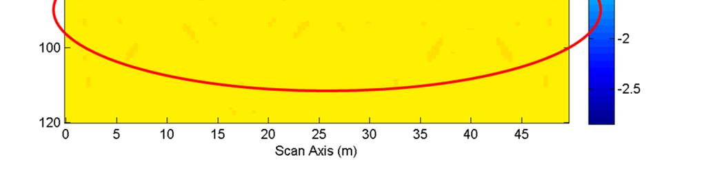
5 Line 1 Line 2 2 m 60 m 12,1 m 2 m 2 m 2 m 12,5 m 2 m 3.4 m 2 m 7 m 3 m Figure 3. The illustration of Japan Cave. The white cylinder represents cavity, and colored lines (red, yellow and purple) are the profiles chosen to be modeled. The physical parameters used in forward modelling process is shown in Table 1. Table 1. Rock electromagnetic properties in Japan Cave Dago Rock Type Resistivity Relative dielectric Relative magnetic Velocity (m/ns) constant permeability Tuff 10 5 [13] 2.6 [14] [15] air 1, [16] 1 [17] [18] soil 1000 [19] 5 [19] [20] m 3. Result The models used in this research and the synthetic radargrams resulted by those models are shown in the figures below: V(m/s) Figure 4. Homogenous model Figure 5. Line 1 geological model 4


6 V(m/s) V(m/s) Figure 6. Line 2 geological model Figure 7. Line 3 geological model Forward modelling in 100 MHz frequency: Figure 8. Homogenous synthetic radargram of 100MHz antenna 5

7 Figure 9. Line 1 synthetic radargram of 100MHz antenna Figure 10. Line 2 synthetic radargram of 100MHz antenna 6


8 Figure 11. Line 3 synthetic radargram of 100MHz antenna Forward modelling in 50 MHz frequency: Figure 12. Homogenous synthetic radargram of 50MHz antenna 7


9 Figure 13. Line 1 synthetic radargram of 50MHz antenna Figure 14. Line 2 synthetic radargram of 50MHz antenna 8


10 Figure 15. Line 3 synthetic radargram of 50MHz antenna 4. Conclusion By assuming physical parameters used, modelling results indicate that forward modelling on a frequency of 100 MHz could not identify the interface between the tuff and air, but all the three synthetic models can still distinguish the boundary layer between the soil and tuff. However, forward modelling at a frequency of 50 MHz, with deeper penetration depth, all the three synthetic models can identify the boundary layer between the soil and tuff, and also the interface between the tuff and air. The comparison can be seen in Figure 16. 9


, should still be accommodated by a GPR 100 MHz.")
11 Figure 16. Comparison of forward modelling results of 50 MHz and 100 MHz frequency in line 2. The differences between the forward modelling results happen because the energy assigned to send back wave reflection resulted by the interface of tuff-air toward the surface is insufficient at the test frequency of 100 MHz. Nevertheless, at a frequency of 50 MHz, with higher penetration depth, there is still enough energy left to deliver the reflection wave of tuff-air boundary layer toward the surface, and therefore the contrast can still be read via the receiver. However, this test should still be validated by using data from field acquisition; because the investigation depth of Japan cave (6-10 meters), should still be accommodated by a GPR 100 MHz. References [1] De Bruyn I A, Bell F G 2001 The occurrence of sinkholes and subsidence depressions in the far West Rand and Gauteng province, South Africa, and their engineering implications J. Environ Eng. Geosci [2] Waltham T, Bell F 2005 Sinkholes and Subsidence.Karst and Cavernous Rocks in Engineering and Construction ed Culshaw M (Berlin: Springer) p 382 [3] Mareš S, Kelly, W E. & Mazač O 1997 Applied Geophysics in Environmental Engineering and Science (Prague: Universita Karlova) p 382 [4] Reynolds J M 1997 An Introduction to Applied and Environmental Geophysics (Chichester : Wiley) 10
12 [5] Davis J L and A P Annan 1989 Ground-penetrating radar for the high resolution mapping of soil and rock stratigraphy J. Geophys. Prospec [6] Widodo, Aditama I F, Syaifullah K, Mahya M J, Hidayat M 2016 Detecting buried human bodies using ground-penetrating radar J. Earth Sci. Res. ISSN [7] Annan A P 2001 Ground penetrating radar workshop notes (Mississauga: Sensors and Software Inc) [8] Kofman L, Ronen A & Frydman S 2006 Detection of model voids by identifying reverberation phenomena in GPR records J. Appl. Geophys [9] Gosar A 2012 Analysis of the capabilities of low frequency ground penetrating radar for cavities detection in rough terrain conditions: the case of divača cave, Slovenia Acta Carsologica 1(41), [10] Silitonga P H 1973, Peta Geologi Lembar Bandung scale 1 : (Bandung: PPPG) [11] Silitonga P H 1979, Peta Geologi Lembar Bandung scale 1 : (Bandung: PPPG) [12] Ardi N D, Iryanti M 2009 Profil resistivitas 2D pada gua bawah tanah dengan metode geolistrik konfigurasi wenner-schlumberger (studi kasus Gua Dago Pakar, Bandung) J. Pengajaran MIPA 14 L2 [13] Telford W M, Geldart L P, Sheriff R E & Keys D A 1976 Applied Geophysics (London : Cambridge University Press) [14] Campbell M J and Ulrichs J 1969 Electrical properties of rocks and their significance for lunar radar observations J. Geophys. Res [15] Scott J H 1971 Electrical And Magnetic Properties of Rock And Soils: Electromagnetic Pulse Theoretical Notes AFWL EMP 2-1 [16] Pawar S D, Murugavel P, Lal D M 2009 Effect of relative humidity and sea level pressure on electrical conductivity of air over Indian Ocean J. Geophys. Res. 114 D02205 [17] Davis J L and Annan A P 1989 Ground-penetrating radar for high-resolution mapping of soil and rock stratigraphy J. Geophys. Prospec [18] Cullity B D and Graham C D 2008 Introduction to Magnetic Materials 2nd edition [19] Kapfer, Robert M 2005 An advanced specular and diffuse Bidirectional Reflectance Distribution Function target model for a synthetic aperture ground penetrating radar Thesis from Rochester Institute of Technology. Accessed from [20] Nettleton L.L 1940 Geophysical Prospecting for Oil (New York: McGraw Hill Book Co., Inc.) p
Ground subsidence is a worldwide problem especially
 Ground Engineering: GPR A Case Study on Ground Subsidence Using Ground Penetrating Radar Nur Azwin Ismail and Rosli Saad Geophysics Section, School of Physics, Universiti Sains Malaysia Ground subsidence
Detecting Buried Human Bodies Using Ground-Penetrating Radar
 Earth Science Research; Vol. 5, No. 2; 2016 ISSN 1927-0542 E-ISSN 1927-0550 Published by Canadian Center of Science and Education Detecting Buried Human Bodies Using Ground-Penetrating Radar Widodo 1,
Georadar and geoelectricity method to identify the determine zone of sliding landslide
 IOP Conference Series: Earth and Environmental Science PAPER OPEN ACCESS Georadar and geoelectricity method to identify the determine zone of sliding landslide To cite this article: Y K Dalimunthe and
A Case Study on Ground Subsidence Using Ground Penetrating Radar
 2012 International Conference on Environmental, Biomedical and Biotechnology IPCBEE vol.41 (2012) (2012) IACSIT Press, Singapore A Case Study on Ground Using Ground Penetrating Radar Nur Azwin Ismail +
Georadar Application for Dam Safety Study (Case Study of Selorejo Dam)
") The 2 nd International Seminar on Science and Technology 155 Georadar Application for Dam Safety Study (Case Study of Selorejo Dam) Teguh Winari 1, Kamsiyah Windianita 1, and Fahmi Hidayat 1 Abstract Selorejo
The 2 nd International Seminar on Science and Technology 155 Georadar Application for Dam Safety Study (Case Study of Selorejo Dam) Teguh Winari 1, Kamsiyah Windianita 1, and Fahmi Hidayat 1 Abstract Selorejo
Detecting the Weathering Structure of Shallow Geology via for Ground-Penetrating Radar
 International Journal of Applied Science and Engineering 2009. 6, 3: 207-214 Detecting the Weathering Structure of Shallow Geology via for Ground-Penetrating Radar Kun Fa Lee abc *, Reason Hong b, Yu Min
Coal Layer Identification using Electrical Resistivity Imaging Method in Sinjai Area South Sulawesi
 Journal of Physics: Conference Series PAPER OPEN ACCESS Coal Layer Identification using Electrical Resistivity Imaging Method in Sinjai Area South Sulawesi To cite this article: Andi Ilham Samanlangi 2018
GPR profiling and electrical resistivity tomography for buried cavity detection: a test site at the Abbaye de l'ouye (France)
") GPR profiling and electrical resistivity tomography for buried cavity detection: a test site at the Abbaye de l'ouye (France) Nerouz BOUBAKI, Albane SAINTENOY, Piotr TUCHOLKA IDES - UMR 8148 CNRS, Université
GPR profiling and electrical resistivity tomography for buried cavity detection: a test site at the Abbaye de l'ouye (France) Nerouz BOUBAKI, Albane SAINTENOY, Piotr TUCHOLKA IDES - UMR 8148 CNRS, Université
GEOPHYSICAL SITE CHARACTERIZATION IN SUPPORT OF HIGHWAY EXPANSION PROJECT
 GEOPHYSICAL SITE CHARACTERIZATION IN SUPPORT OF HIGHWAY EXPANSION PROJECT * Shane Hickman, * Todd Lippincott, * Steve Cardimona, * Neil Anderson, and + Tim Newton * The University of Missouri-Rolla Department
Application of Ground Penetrating Radar for hydro-geological study
 Journal of Scientific & Industrial Research Vol. 65, February 2006, pp. 160-164 Application of Ground Penetrating Radar for hydro-geological study K K K Singh* Central Mining Research Institute, Dhanbad
Geophysics for Environmental and Geotechnical Applications
 Geophysics for Environmental and Geotechnical Applications Dr. Katherine Grote University of Wisconsin Eau Claire Why Use Geophysics? Improve the quality of site characterization (higher resolution and
Magnetic properties of soils from landslide potential area (Case study: Pasir Ipis-Lembang, West Bandung)
") Journal of Physics: Conference Series PAPER OPEN ACCESS Magnetic properties of soils from landslide potential area (Case study: Pasir Ipis-Lembang, West Bandung) Related content - Magnetic Properties of
Journal of Physics: Conference Series PAPER OPEN ACCESS Magnetic properties of soils from landslide potential area (Case study: Pasir Ipis-Lembang, West Bandung) Related content - Magnetic Properties of
Hazard Mapping Along the Dead Sea Shoreline
 FIG Working Week in Marrakech, Morocco 18-22 May 2011 Hazard Mapping Along the Dead Sea Shoreline Rami Al-Ruzouq, Abdullah Al-Zuobi, AbdEl-Rahman Abueladas, Emad Akkawi Department of Surveying and Geomatics
Dielectric constant determination using ground-penetrating radar reflection coefficients
 Ž. Journal of Applied Geophysics 43 000 189 197 www.elsevier.nlrlocaterjappgeo Dielectric constant determination using ground-penetrating radar reflection coefficients Philip M. Reppert ), F. Dale Morgan,
Gravity Data Analysis and Modelling for Basin Sedimen of Eastern Java Blocks
 Journal of Physics: Conference Series PAPER OPEN ACCESS Gravity Data Analysis and Modelling for Basin Sedimen of Eastern Java Blocks To cite this article: Luthfia Khoirunnia 2016 J. Phys.: Conf. Ser. 776
Potential collapse due to geological structures influence in Seropan Cave, Gunung Kidul, Yogyakarta, Indonesia
 IOP Conference Series: Earth and Environmental Science PAPER OPEN ACCESS Potential collapse due to geological structures influence in Seropan Cave, Gunung Kidul, Yogyakarta, Indonesia To cite this article:
VLF -MT Survey around Nakadake crater at Aso Volcano
 IOP Conference Series: Earth and Environmental Science OPEN ACCESS VLF -MT Survey around Nakadake crater at Aso Volcano To cite this article: A Harja et al 2016 IOP Conf. Ser.: Earth Environ. Sci. 29 012016
NMO residual reduction on medium anisotropy in field X using Fomel and Stovas method
 Journal of Physics: Conference Series PAPER OPEN ACCESS NMO residual reduction on medium anisotropy in field X using Fomel and Stovas method To cite this article: M S Rosid et al 018 J. Phys.: Conf. Ser.
A GPR ASSESSMENT OF THE PREHISTORIC NAPLES CANAL NAPLES, FLORIDA ARCHAEOLOGICAL AND HISTORICAL CONSERVANCY, INC.
 A GPR ASSESSMENT OF THE PREHISTORIC NAPLES CANAL NAPLES, FLORIDA ARCHAEOLOGICAL AND HISTORICAL CONSERVANCY, INC. AHC TECNICAL REPORT NO. 1004 DECEMBER 2013 A GPR ASSESSMENT OF THE PREHISTORIC NAPLES CANAL
FINAL REPORT GEOPHYSICAL INVESTIGATION WATER TOWER NO. 6 SITE PLANT CITY, FL
 APPENDIX B FINAL REPORT GEOPHYSICAL INVESTIGATION WATER TOWER NO. 6 SITE PLANT CITY, FL Prepared for Madrid Engineering Group, Inc. Bartow, FL Prepared by GeoView, Inc. St. Petersburg, FL February 28,
Geophysical Applications GPR Ground Penetrating Radar
 Overview: Basics of GPR Radar-wave velocity, attenuation and skin depth Modes of acquisition The Radar-range equation Dielectric properties of materials and relation to porosity Case studies [Archeology,
Design of Deformation Monitoring System for Volcano Mitigation
 Journal of Physics: Conference Series PAPER OPEN ACCESS Design of Deformation Monitoring System for Volcano Mitigation To cite this article: M R F Islamy et al 2016 J. Phys.: Conf. Ser. 739 012084 View
Magnetotelluric (MT) Method
 Method") Magnetotelluric (MT) Method Dr. Hendra Grandis Graduate Program in Applied Geophysics Faculty of Mining and Petroleum Engineering ITB Geophysical Methods Techniques applying physical laws (or theory) to
Magnetotelluric (MT) Method Dr. Hendra Grandis Graduate Program in Applied Geophysics Faculty of Mining and Petroleum Engineering ITB Geophysical Methods Techniques applying physical laws (or theory) to
Available online Journal of Scientific and Engineering Research, 2016, 3(2):1-7. Research Article
:1-7. Research Article") Available online www.jsaer.com, 2016, 3(2):1-7 Research Article ISSN: 2394-2630 CODEN(USA): JSERBR Assessment of the Reliability of Magnetic Method to Delineate Geologic Features in a Basement Complex:
Available online www.jsaer.com, 2016, 3(2):1-7 Research Article ISSN: 2394-2630 CODEN(USA): JSERBR Assessment of the Reliability of Magnetic Method to Delineate Geologic Features in a Basement Complex:
Foundation pile and cavity detection by the 3D directional borehole radar system, ReflexTracker
 Foundation pile and cavity detection by the 3D directional borehole radar system, ReflexTracker K. Wada, S. Karasawa, K. Kawata, T. Ueki Matsunaga Geo-survey Co., Ltd. 1-23-1 Ooi, 140-0014, Tokyo, Japan
PE OIL AND GAS EXPLORATION METHODS COURSE STRUCTURE. I. FUNDAMENTAL CONSIDERATIONS (5 Hrs.) III. SEISMIC REFLECTION METHOD
 III. SEISMIC REFLECTION METHOD") PE6050 - OIL AND GAS EXPLORATION METHODS Total Hours: 50 Faculty: Dr. Rajesh R Nair COURSE STRUCTURE I. FUNDAMENTAL CONSIDERATIONS (5 Hrs.) - Stress - Strain Relationship - Elastic Coefficients - Seismic
PE6050 - OIL AND GAS EXPLORATION METHODS Total Hours: 50 Faculty: Dr. Rajesh R Nair COURSE STRUCTURE I. FUNDAMENTAL CONSIDERATIONS (5 Hrs.) - Stress - Strain Relationship - Elastic Coefficients - Seismic
ERTH3021: Exploration and Mining Geophysics
 Course Profile ERTH3021: Exploration and Mining Geophysics Semester 2, 2014 Course Outline: This course builds on the general introduction provided by ERTH2020, and examines common applied-geophysical
2-D Resistivity Study: The Horizontal Resolution Improvement by Introducing the Enhancing Horizontal Resolution (EHR) Technique
 Technique") Open Journal of Geology, 213, 3, 1-6 doi:1.4236/ojg.213.32b1 Published Online April 213 (http://www.scirp.org/journal/ojg) 2-D Resistivity Study: The Horizontal Resolution Improvement by Introducing the
Open Journal of Geology, 213, 3, 1-6 doi:1.4236/ojg.213.32b1 Published Online April 213 (http://www.scirp.org/journal/ojg) 2-D Resistivity Study: The Horizontal Resolution Improvement by Introducing the
Geophysical mapping and imaging of soil structures: basic overview
 Geophysical mapping and imaging of soil structures: basic overview Stéphane Garambois Landslide team, LGIT, Université Joseph Fourier 3D imaging of the water table (seismic) Geophysical methods 1 Plan
SURVEYING FOR GOLD. Page 1 of 25
 SURVEYING FOR GOLD Page 1 of 25 Page 2 of 25 Contents Introduction to Lozar Radar... 4 The Ground Penetrating Radar (GPR) system and Methodology... 4 Lozar Radar Surveying for Gold... 7 How Lozar Radar
ambiguity in earth sciences IESO Geophysics Section Eddy hartantyo, Lab Geofisika FMIPA UGM
 ambiguity in earth sciences IESO Geophysics Section Eddy hartantyo, Lab Geofisika FMIPA UGM Pelatihan Tahap II IESO Teknik Geologi UGM Februari 2009 1 Introduction Photos from http://www.eegs.org/whatis/
The Application of Depth Migration for Processing GPR Data
 The Application of Depth Migration for Processing GPR Data Dang Hoai Trung 1, *, Nguyen Van Giang, and Nguyen Thanh Van 1 1 Faculty of Physics and Engineering Physics, VNUHCM University of Science Vietnam
Geophysical Investigation of Ground Water Using Vertical Electrical Sounding and Seismic Refraction Methods
 International Journal of Petroleum and Petrochemical Engineering (IJPPE) Volume 2, Issue 1, 2016, PP 6-11 ISSN 2454-7980 (Online) www.arcjournals.org Geophysical Investigation of Ground Water Using Vertical
INTEGRATED GEOPHYSICAL INVESTIGATION OF SEQUENCE OF DEPOSITION OF SEDIMENTARY STRATA IN ABAKALIKI, NIGERIA ABSTRACT
 INTEGRATED GEOPHYSICAL INVESTIGATION OF SEQUENCE OF DEPOSITION OF SEDIMENTARY STRATA IN ABAKALIKI, NIGERIA Agha S.O Dept. of Industrial Physics Ebonyi State University, Abakaliki, Nigeria & Arua A.I Dept.
INTRODUCTION TO APPLIED GEOPHYSICS
 INTRODUCTION TO APPLIED GEOPHYSICS EXPLORING THE SHALL0W SUBSURFACE H. Robert Burger Anne F. Sheehan Craig H.Jones VERSITY OF COLORADO VERSITY OF COLORADO W. W. NORTON & COMPANY NEW YORK LONDON Contents
Florida International University, Department of Earth and Environment GLY 5475 Spring 2017: Exploration Geophysics Lec: MWF 11:00-11:50, Room AHC5-357
 Florida International University, Department of Earth and Environment GLY 5475 Spring 2017: Exploration Geophysics Lec: MWF 11:00-11:50, Room AHC5-357 Dr. Dean Whitman AHC5-396 Tel: 348-3089 Office Hours:
S.I. Fadele, M.Sc. 1 ; P.O. Sule, Ph.D. 1 ; and B.B.M. Dewu, Ph.D * ABSTRACT
 The Use of Vertical Electrical Sounding (VES) for Groundwater Exploration around Nigerian College of Aviation Technology (NCAT), Zaria, Kaduna State, Nigeria. S.I. Fadele, M.Sc. 1 ; P.O. Sule, Ph.D. 1
GPR surveys at Nõmmküla Detection of underground water routes
 GPR surveys at Nõmmküla 2009 Detection of underground water routes Tomi Herronen & Timo Saarenketo 2009 1. Introduction The purpose of this survey was to locate possible underground water routes (rivers)
K. A. Murana, P. Sule, A.L. Ahmed, E.M. Abraham and E.G. Obande. 1. Introduction
 Subsurface stratigraphic mapping using geoelectric method and its impact on development in Federal College of Education (technical) Gusau, Zamfara State, Nigeria K. A. Murana, P. Sule, A.L. Ahmed, E.M.
Geologic Structural Identification from 3D Stratigraphic Modeling of Geologic Map
 Geologic Structural Identification from 3D Stratigraphic Modeling of Geologic Map Alva Kurniawan 1 Abstract Three dimensions stratigraphic model can be created from geologic stratigraphic data of geologic
RADAR REMOTE SENSING OF PLANETARY SURFACES
 RADAR REMOTE SENSING OF PLANETARY SURFACES BRUCE A. CAMPBELL Smithsonian Institution CAMBRIDGE UNIVERSITY PRESS Contents Acknowledgments page ix 1 Introduction 1 1.1 Radar remote sensing 1 1.2 Historical
Hamed Aber 1 : Islamic Azad University, Science and Research branch, Tehran, Iran. Mir Sattar Meshin chi asl 2 :
 Present a Proper Pattern for Choose Best Electrode Array Based on Geological Structure Investigating in Geoelectrical Tomography, in order to Get the Highest Resolution Image of the Subsurface Hamed Aber
Applied Geophysics for Environmental Site Characterization and Remediation
 Applied Geophysics for Environmental Site Characterization and Remediation MSECA Webinar September 24, 2015 John Mundell, P.E., L.P.G. Ryan Brumbaugh, L.P.G. MUNDELL & ASSOCIATES, INC. Webinar Objective
The three-year mapping and monitoring of underground cavity expansion with 2D resistivity survey: What has revealed?
 The three-year mapping and monitoring of underground cavity expansion with 2D resistivity survey: What has revealed? Peangta Satarugsa 1, Winit Youngmee 1 and Suvijuk Meesawat 1 1. Department of Geotechnology,
Geophysics and Mapping. presented by: Stephen Brown
 Geophysics and Mapping presented by: Stephen Brown Recommended book for INIGEMM Geophysics for the mineral exploration geoscientist, by Michael Dentith and Stephen Mudge, Cambridge University Press, 2014.
Electrical Surveying (part A)
") Electrical Surveying (part A) Dr. Laurent Marescot Course given at the University of Fribourg (2009) Contact: laurent@tomoquest.com www.tomoquest.com 1 Introduction Electrical surveying Resistivity method
Electrical Surveying (part A) Dr. Laurent Marescot Course given at the University of Fribourg (2009) Contact: laurent@tomoquest.com www.tomoquest.com 1 Introduction Electrical surveying Resistivity method
EFFECTS OF SOIL PHYSICAL PROPERTIES ON LAND- MINES DETECTION USING MICROSTRIP ANTENNA AS A SENSOR
 Progress In Electromagnetics Research C, Vol. 7, 13 24, 2009 EFFECTS OF SOIL PHYSICAL PROPERTIES ON LAND- MINES DETECTION USING MICROSTRIP ANTENNA AS A SENSOR S. H. Zainud-Deen, M. E. Badr, E. M. Ali,
The fields of application of the Ground Penetrating Radar (GPR) are: CONSTRUCTION APPLICATIONS
 are: CONSTRUCTION APPLICATIONS") I.Industrial (technical) applications of geophysical methods used by the Archeo-geophysics laboratory in construction, plumbing, geotechnical engineering, engineering geology, mining, electricity power
I.Industrial (technical) applications of geophysical methods used by the Archeo-geophysics laboratory in construction, plumbing, geotechnical engineering, engineering geology, mining, electricity power
GPR SURVEYS AT SOME 700 YEARS-OLD STRUCTURES IN THE OLD CITY OF CAIRO, EGYPT.
 GPR SURVEYS AT SOME 700 YEARS-OLD STRUCTURES IN THE OLD CITY OF CAIRO, EGYPT. Mohamed G. El-Behiry Geophysics Department, Faculty of Science, Cairo University, Giza, Egypt. Abstract Remediation and restoration
 SHEET TITLE: DRAWN BY: J.M.CLARK FILE NO. CHECKED BY: W.S. JORDAN APPROVED BY: DATE: FIGURE SHEET TITLE: DRAWN BY: J.M.CLARK FILE NO. CHECKED BY: W.S. JORDAN APPROVED BY: DATE: FIGURE SPOTLIGHT Technical
The Subsurface Soil Effects Study Using the Short and Long Predominant Periods From H/V Spectrum In Yogyakarta City
 Paper ID 90 The Subsurface Soil Effects Study Using the Short and Long Predominant Periods From H/V Spectrum In Yogyakarta City Z.L. Kyaw 1,2*, S. Pramumijoyo 2, S. Husein 2, T.F. Fathani 3, J. Kiyono
Although most karstic regions
 Urban Geophysics: Geophysical Signature of Mount Bonnell Fault and Its Karstic Features in Austin, TX by Mustafa Saribudak, Environmental Geophysics Associates, Austin, TX Although most karstic regions
Triggering of great earthquakes: calculation and analysis of combined tidal effect of the Moon and Sun
 IOP Conference Series: Earth and Environmental Science PAPER OPEN ACCESS Triggering of great earthquakes: calculation and analysis of combined tidal effect of the Moon and Sun Related content - INTERACTION
STATISTICAL ANALYSIS OF GPR AND SPT METHODS FOR SINKHOLE INVESTIGATION IN COVERED KARST TERRAIN, WEST-CENTRAL FLORIDA, USA
 STATISTICAL ANALYSIS OF GPR AND SPT METHODS FOR SINKHOLE INVESTIGATION IN COVERED KARST TERRAIN, WEST-CENTRAL FLORIDA, USA Henok Kiflu, Sarah Kruse Dept. of Geology, University of South Florida, 4202 E.
TIME DOMAIN ELECTROMAGNETICS IN MARS ANALOG ENVIRONMENTS: COMPARING TWO FIELD STUDIES. Joern A. Jernsletten 1
 AAS 06-256 TIME DOMAIN ELECTROMAGNETICS IN MARS ANALOG ENVIRONMENTS: COMPARING TWO FIELD STUDIES Joern A. Jernsletten 1 The purpose of this study is to evaluate the use of (diffusive) Time Domain Electromagnetics
LOZAR RADAR INTRODUCTORY PRESENTATION COAL SURVEYING
 LOZAR RADAR INTRODUCTORY PRESENTATION COAL SURVEYING WWW.LOZARRADAR.COM ABOUT LOZAR RADAR Lozar Radar is a ground-scanning device, which verifies and investigates the presence of mineral resources and
ENVIRONMENTAL AND ENGINEERING GEOPHYSICS
 ENVIRONMENTAL AND ENGINEERING GEOPHYSICS Environmental Engineering MSc 08/09 nd semester COURSE COMMUNICATION DOCUMENT University of Miskolc Faculty of Earth Science and Engineering Institute of Geophysics
Geophysical Investigation of a 19th Century Archeological Site, Boston College K. Corcoran, J. Hager, M. Carnevale
 Geophysical Investigation of a 19th Century Archeological Site, Boston College K. Corcoran, J. Hager, M. Carnevale Hager GeoScience, Inc., Waltham, MA ------------------------------------------------------------------------
Sabal Trail Pipeline Project Evaluation of Karst Topography and Sinkhole Potential for Pipeline and Facilities
 November 11, 2014 Sabal Trail Pipeline Project Evaluation of Karst Topography and Sinkhole Potential for Pipeline and Facilities Gulf Interstate Engineering Attention: Mr. Denys Stavnychyi - Project Engineer
E : Ground-penetrating radar (GPR)
") Geophysics 3 March 009 E : Ground-penetrating radar (GPR) The EM methods in section D use low frequency signals that trael in the Earth by diffusion. These methods can image resistiity of the Earth on
Geophysics 3 March 009 E : Ground-penetrating radar (GPR) The EM methods in section D use low frequency signals that trael in the Earth by diffusion. These methods can image resistiity of the Earth on
TRC1504: Alternative Uses of Ground Penetrating Radar in Highway in Construction and Maintenance. Elisha Wright-Kehner, P.E.
 TRC1504: Alternative Uses of Ground Penetrating Radar in Highway in Construction and Maintenance Elisha Wright-Kehner, P.E. Why GPR? Practicality Non-invasive (Non-destructive Testing - NDT) Real-time
ELECTRICAL RESISTIVITY SURVEY OF INTREPID POTASH INJECTION WELL SITE: EDDY COUNTY, NEW MEXICO
 NCKRI REPORT OF INVESTIGATION 3 ELECTRICAL RESISTIVITY SURVEY OF INTREPID POTASH INJECTION WELL SITE: EDDY COUNTY, NEW MEXICO www.nckri.org NATIONAL CAVE AND KARST RESEARCH INSTITUTE REPORT OF INVESTIGATION
GM 1.4. SEG/Houston 2005 Annual Meeting 639
 storage recovery project in Leyden, Colorado Kristofer Davis *, Yaoguo Li, Michael Batzle, and Bob Raynolds** Center for Gravity, Electrical, and Magnetic Studies, Department of Geophysics, Colorado School
3-D ground-penetrating radar surveys on a frozen river lagoon
 3-D ground-penetrating radar surveys on a frozen river lagoon Monica Moldoveanu and Robert R. tewart ABTRACT Ground-penetrating radar (GPR) surveys were acquired at Bowness Park, Calgary to characterize
Development of geophysical investigation for verifying treatment efficiency of underground cavities
 Development of geophysical investigation for verifying treatment efficiency of underground cavities Hasan A. Kamal* Kuwait Institute for Scientific Research, Infrastructure Risk and Reliability Program,
The Use of Vertical Electrical Sounding (VES) for Subsurface Geophysical Investigation around Bomo Area, Kaduna State, Nigeria
 for Subsurface Geophysical Investigation around Bomo Area, Kaduna State, Nigeria") IOSR Journal of Engineering (IOSRJEN) e-issn: 2250-3021, p-issn: 2278-8719 Vol. 3, Issue 1 (Jan. 2013), V4 PP 10-15 The Use of Vertical Electrical Sounding (VES) for Subsurface Geophysical Investigation
IOSR Journal of Engineering (IOSRJEN) e-issn: 2250-3021, p-issn: 2278-8719 Vol. 3, Issue 1 (Jan. 2013), V4 PP 10-15 The Use of Vertical Electrical Sounding (VES) for Subsurface Geophysical Investigation
The exploding-reflector concept for ground-penetrating-radar modeling
 ANNALS OF GEOPHYSCS, VOL. 45, N. 3/4, June/August 2002 The exploding-reflector concept for ground-penetrating-radar modeling José M. Carcione ( 1 ), Laura Piñero Feliciangeli ( 2 ) and Michela Zamparo
APPLIED GEOPHYSICS. MS in Petroleum Engineering. Semester 1, 2018/19 COURSE COMMUNICATION FOLDER
 APPLIED GEOPHYSICS MS in Petroleum Engineering Semester 1, 2018/19 COURSE COMMUNICATION FOLDER University of Miskolc Faculty of Earth Science and Engineering Institute of Geophysics and Geoinformatics
Description of field trench configuration and processing and interpretation of ground penetrating radar s data
 IOSR Journal of Applied Geology and Geophysics (IOSR-JAGG) e-issn: 2321 0990, p-issn: 2321 0982.Volume 5, Issue 3 Ver. I (May. - June. 2017), PP 01-05 www.iosrjournals.org Description of field trench configuration
In-seam GPR and 2-C seismic investigations at the Goderich, Ontario salt mine
 In-seam GPR and 2-C seismic investigations at the Goderich, Ontario salt mine Jill Belisle and Robert R. Stewart In-seam techniques ABSTRACT In-seam GPR and 2-C seismic techniques used in conjunction with
Use of Ground Penetrating Radar to identify the presence and orientation of Graves in St. Brigitts Cemetery, Bergen New York
 The College at Brockport: State University of New York Digital Commons @Brockport Geotechnical Survey Reports Department of the Earth Sciences 2013 Use of Ground Penetrating Radar to identify the presence
GLE 594: An introduction to applied geophysics
 GL 594: An introduction to applied geophysics Ground Penetrating Radar Fall 005 Ground Penetrating Radar Reading Today: 309-316 Next class: 316-39 Introduction to GPR Using the reflection (and sometimes
Prevention and remediation of rockslide at left portal of north tunnel of Da Nang Qu ang Ngai expressway in Quang Nam, Vietnam
 IOP Conference Series: Earth and Environmental Science PAPER OPEN ACCESS Prevention and remediation of rockslide at left portal of north tunnel of Da Nang Qu ang Ngai expressway in Quang Nam, Vietnam To
Use of Geophysical Software for Interpretation of Ice-Penetrating Radar Data and Mapping of Polar Ice Sheets
 Use of Geophysical Software for Interpretation of Ice-Penetrating Radar Data and Mapping of Polar Ice Sheets Alex O. Martinez University of Kansas 2335 Irving Hill Road Lawrence, KS 66045-7612 http://cresis.ku.edu
Discussion on the 3D visualizing of 1: geological map
 IOP Conference Series: Earth and Environmental Science PAPER OPEN ACCESS Discussion on the 3D visualizing of 1:200 000 geological map To cite this article: Xiaopeng Wang 2018 IOP Conf. Ser.: Earth Environ.
Internet of Things (IoT) for Urban Detailed Spatial Plan with Zoning Map
 for Urban Detailed Spatial Plan with Zoning Map") IOP Conference Series: Materials Science and Engineering PAPER OPEN ACCESS Internet of Things (IoT) for Urban Detailed Spatial Plan with Zoning Map To cite this article: A Mulyana et al 2018 IOP Conf.
IOP Conference Series: Materials Science and Engineering PAPER OPEN ACCESS Internet of Things (IoT) for Urban Detailed Spatial Plan with Zoning Map To cite this article: A Mulyana et al 2018 IOP Conf.
GEOL4714 Final Exam Fall 2005, C. H. Jones instructor
 GEOL4714 Final Exam Fall 2005 p. 1 GEOL4714 Final Exam Fall 2005, C. H. Jones instructor Name: Student ID #: Feel free to use the back of the sheets for answers needing more space. (1) (10 pts) For each
Assessment of accuracy in determining Atterberg limits for four Iraqi local soil laboratories
 IOP Conference Series: Materials Science and Engineering PAPER OPEN ACCESS Assessment of accuracy in determining Atterberg limits for four Iraqi local soil laboratories To cite this article: H O Abbas
Pseudo-seismic wavelet transformation of transient electromagnetic response in engineering geology exploration
 GEOPHYSICAL RESEARCH LETTERS, VOL. 34, L645, doi:.29/27gl36, 27 Pseudo-seismic wavelet transformation of transient electromagnetic response in engineering geology exploration G. Q. Xue, Y. J. Yan, 2 and
Electrical prospecting involves detection of surface effects produced by electrical current flow in the ground.
 Electrical Surveys in Geophysics Electrical prospecting involves detection of surface effects produced by electrical current flow in the ground. Electrical resistivity method Induced polarization (IP)
Last Time. Today s s Agenda. Geophysics. Geophysics. Geophysics. MAS 603: Geological Oceanography. Lecture 21: Geophysics 1: Gravity
 UNIVERSITY OF SOUTH ALABAMA Last Time MAS 603: Geological Oceanography Extinctions Lecture 21: 1: http://www.cartoonstock.com/newscartoons/cartoonists/for/lowres/forn441l.jpg Today s s Agenda Introduction
Abstract. Introduction. Damanik, C. T. 1, Karina Meninta 1, Puspa Khaerani 1, M. Kurniawan Alfadli 1, Undang Mardiana 1, Febriwan Mohamad 1
 Geoelectric Investigation on Distribution of Metal Waste and Its Implication to Groundwater Condition in Pesarean Village, Adiwena Sub-district, Tegal Regency, Central Java Damanik, C. T. 1, Karina Meninta
Development of Porosity Measurement Method in Shale Gas Reservoir Rock
 Journal of Physics: Conference Series PAPER OPEN ACCESS Development of Measurement Method in Shale Gas Reservoir Rock To cite this article: Alita Siswandani and BagusEndar B. Nurhandoko 2016 J. Phys.:
Comparison of Two Geophysical Methods to Investigate Sand and Gravel Deposits, a Case Study in Chumphuang District, Nakhornratchasima, Thailand
 Australian Journal of Basic and Applied Sciences, 7(7): 761-767, 2013 ISSN 1991-8178 Comparison of Two Geophysical Methods to Investigate and Gravel Deposits, a Case Study in Chumphuang District, Nakhornratchasima,
FUNDAMENTALS OF ENGINEERING GEOLOGY
 FUNDAMENTALS OF ENGINEERING GEOLOGY Prof. Dr. HUSSEIN HAMEED KARIM Building and Construction Engineering Department 2012 Preface The impulse to write this book stemmed from a course of geology given by
LAKE SEDIMENT THICKNESS ESTIMATION USING GROUND PENETRATING RADAR
 LAKE SEDIMENT THICKNESS ESTIMATION USING GROUND PENETRATING RADAR Sinam Reema Chanu 1, R.K Chingkhei 2, Manichandra Sanoujam 3, Arun Kumar 4 1 Research Scholar, Department of Earth Sciences, Manipur University,
Research on the defect types judgment in wind turbine blades using ultrasonic NDT
 IOP Conference Series: Materials Science and Engineering PAPER OPEN ACCESS Research on the defect types judgment in wind turbine blades using ultrasonic NDT To cite this article: Suwei Li et al 05 IOP
Determination of Incompressibility, Elasticity and the Rigidity of Surface Soils and Shallow Sediments from Seismic Wave Velocities
 Journal of Earth Sciences and Geotechnical Engineering, vol. 6, no.1, 2016, 99-111 ISSN: 1792-9040 (print), 1792-9660 (online) Scienpress Ltd, 2016 Determination of Incompressibility, Elasticity and the
We 21 C15 Geophysical Investigation for an Assessment of Sinkhole Risk in Schleswig-Holstein/Northern Germany
 We 21 C15 Geophysical Investigation for an Assessment of Sinkhole Risk in Schleswig-Holstein/Northern Germany R. Kirsch* (LLUR-SH), H. Wiederhold (LIAG), W. Rabbel (CAU), E. Erkul (CAU), C. Thomsen (LLUR-SH),
Blasting, fragmentation and wall quality result at West Wanagon slope stability project on Grasberg Mine
 IOP Conference Series: Earth and Environmental Science PAPER OPEN ACCESS Blasting, fragmentation and wall quality result at West Wanagon slope stability project on Grasberg Mine To cite this article: Y
Pseudo 3d Gravity Modeling to Determine Intrusion Contact of Parang Area, Karangsambung, Central java, Jndonesia
 2012 International Conference on Geological and Environmental Sciences IPCBEE vol.3 6(2012) (2012)ICSIT Press, Singapoore Pseudo 3d Gravity Modeling to Determine Intrusion Contact of Parang rea, Karangsambung,
Ground Penetrating Radar Survey Report:
 Ground Penetrating Radar Survey Report: Caiphas Burial Tomb Project Israel Data Acquired May 29, 2008 Report compiled June 4, 2008 Survey and Report Published by Mnemotrix Israel, Ltd. Chief GPR Surveyor,
Sabal Trail Pipeline Project Evaluation of Karst Topography and Sinkhole Potential for Pipeline and Facilities
 November 11, 2014 Sabal Trail Pipeline Project Evaluation of Karst Topography and Sinkhole Potential for Pipeline and Facilities Gulf Interstate Engineering Attention: Mr. Denys Stavnychyi - Project Engineer
Study on Rayleigh Wave Inversion for Estimating Shear-wave Velocity Profile
 PROC. ITB Eng. Science Vol. 35 B, No. 1, 2003, 11-22 11 Study on Rayleigh Wave Inversion for Estimating Shear-wave Velocity Profile T.A. Sanny*, Yoes Avianto* *Geophysical Engineering Department, Faculty
Earthquake Hazard Analysis Methods: A Review
 IOP Conference Series: Earth and Environmental Science PAPER OPEN ACCESS Earthquake Hazard Analysis Methods: A Review To cite this article: A M Sari and A Fakhrurrozi 2018 IOP Conf. Ser.: Earth Environ.
Received 12 February 2010 Accepted 25 March Abstract. Keywords: sounding resistivity, gem-bearing gravel layer, Wenner, Schlumberger
 One Dimensional Resistivity Sounding for Resolving Gem-bearing Gravel Layer: A Comparison of Schlumberger with Wenner Techniques at Bo Rai, Eastern Thailand Piyaphong Chenrai 1, Punya Charusiri 1* and
Geophysics Course Introduction to DC Resistivity
 NORAD supported project in MRRD covering Capacity Building and Institutional Cooperation in the field of Hydrogeology for Faryab Province Afghanistan Geophysics Course Introduction to DC Resistivity By
CONTENTS 1. INTRODUCTION. 2. THE D.C. RESISTIVITY METHOD 2.1 Equipment 2.2 Survey Procedure 2.3 Data Reduction
 (i) CONTENTS 1. INTRODUCTION page 1 2. THE D.C. RESISTIVITY METHOD 2.1 Equipment 2.2 Survey Procedure 2.3 Data Reduction 3 3 3 3 3. GEOPHYSICAL RESULTS 3.1 General 3.2 Discussion 4 4 4 4. LIMITATIONS 5
FINAL REPORT GEOPHYSICAL INVESTIGATION VILLAGE ALHAMBRA RETENTION POND SITE THE VILLAGES, FLORIDA
 FINAL REPORT GEOPHYSICAL INVESTIGATION VILLAGE ALHAMBRA RETENTION POND SITE THE VILLAGES, FLORIDA Prepared for Andreyev Engineering, Inc. Oxford, FL Prepared by GeoView, Inc. St. Petersburg, FL August
Use of Seismic and EM Data for Exploration, Appraisal and Reservoir Characterization
 Use of Seismic and EM Data for Exploration, Appraisal and Reservoir Characterization Anton Ziolkowski and Folke Engelmark Petroleum Geo-Services CSEG, Calgary, 6 May 2009 Outline Exploration, appraisal,