Enhancing Reservoir Characterization using Lightning Strike Data
|
|
|
- Maud Gordon
- 6 years ago
- Views:
Transcription

1 Enhancing Reservoir Characterization using Lightning Strike Data H. Roice Nelson, Jr., Dr. Jim Siebert, & Les R. Denham Dynamic Measurement LLC

2 Outline Lighting Databases: a new geophysical data type Idea s Innovation NLDN, CLDN, & GLD360 Topography, Vegetation, Infrastructure, & Soils Regional, Play Fairway, & Prospect Scale Examples Resistivity Volumes & 3D Seismic Surveys How this new data type can aid reservoir characterization


3 Density map shows Lightning Strikes Cluster Attribute map shows Salt Domes in Same Area Miles Miles


4 Lightning Attributes map shallow stratigraphy Miles

5 Lightning Databases: an old & a new geophysical data type 1752 Benjamin Franklin s kite in the Marcellus Shale Resource Play First magnetic field measurements s Seismic refraction & reflection surveys Schlumberger s first electrical resistivity well log First modern Gravimeter s Magnetotellurics invented, measuring lightning charged earth currents s & 70 s The first image processing of satellite imagery First 3-D seismic survey collected for Gulf Oil Landmark Graphics first stand-alone seismic interpretation workstation CSEM (Controlled Source Electromagnetics) Data mining lightning data as a new Geophysical Data Type. Each new data type sparked millions of dollars in data sales & services.

6 Idea s Innovation Innovation is found someplace between: Inspiration, Perspiration, & Curiosity. Joe Roberts was duck hunting by the Hockley Salt Dome, lightning struck twice, separated by a year.
 currents.")
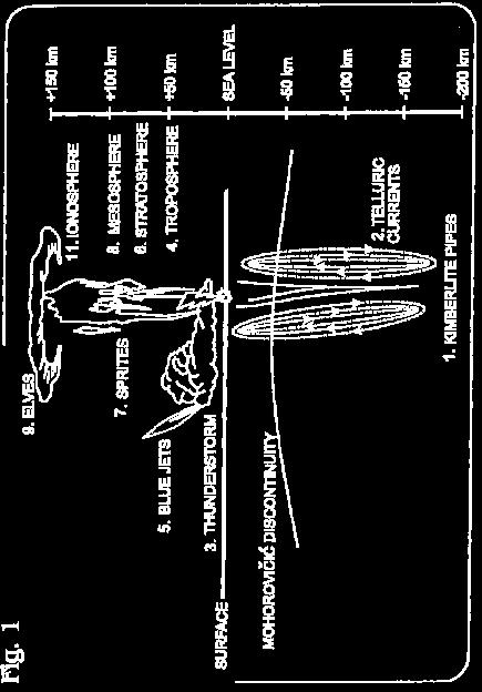
7 350 million annual Lightning Strikes is a rich database to mine Lightning Strikes can travel 250 km (155 miles) cloud-to-cloud, or 2 ½ times the distance of Sprites or Elves. Lightning Strike locations primarily controlled by terralevis (shallow earth) currents.


")
8 330 Sensors record U.S. lightning strike locations with foot ( meter) horizontal resolution


9 Lightning recorded for early storm warning, safety, insurance, and meteorological purposes Dead Cattle along a fence

10 Lightning Measurements Location Time and Duration Rise Time Peak Current Peak-to-Zero Polarity Chi Squared Number of Sensors
11 Lightning Strike Waveform


12 Lightning Strike Waveform

13 Proven and Patented Technology


14 Vaisala and Wipro Partnerships Exclusive worldwide license with Vaisala of Finland to use their data in the NLDN and GLD-360 for natural resource exploration. Agreement with Wipro to clean, process, and handle lightning data according to DML specifications


15 Lightning Maps and Natural Resources Lightning density regionally controlled by meteorology, and locally controlled by terralevis (shallow earth) currents. Colorado County, Texas: White circles known oil & gas fields; Yellow circles new leads from lightning density.


16 Lightning bypasses tall objects to hit geology


17 Northwest Texas example of lunch hour strikes on 08 March 2008 One lightning strike was as close to the towers as the height of the turbines, and still struck downdip of exposed Buda Limestone (outcrops just south of the turbines).

18 Topography, Vegetation, Infrastructure, & Soils Map Layers: GoogleEarth base Peak Current LIDAR Interpretation of the Long Point Fault Soils Unit vector Map


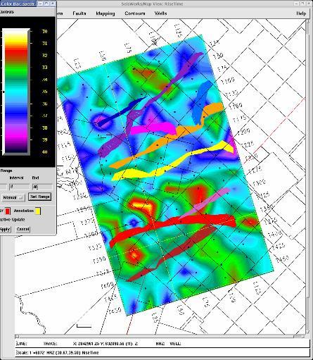
19 A New Potential Fields Method, Supplementing Gravity & Magnetics Topography Gravity Rise-Time Peak Current Peak-to-Zero

20 Michigan Basin Example miles

21 Lightning Analysis provides a quick regional overview


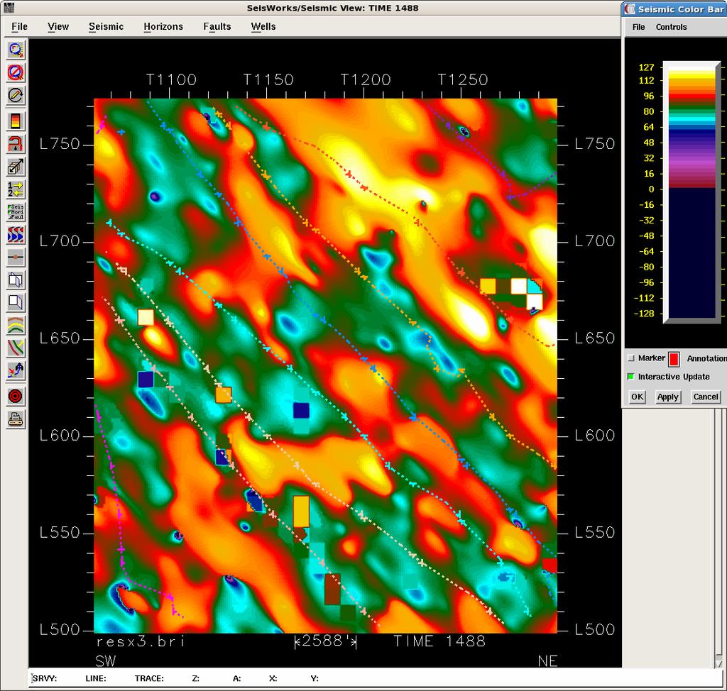
22 More details come out at Play Fairway & Prospect Scales
23 Resistivity Volumes & 3-D Seismic Surveys Lightning as a RC (resistance-capacitor) circuit Key: V(out)= Lightning Stroke V(in)=Thunderstorm Static Charge C=Capacitance between cloud & earth R(1)=resistance of earth below thundercloud R(2)=resistance as static charges rebalanced


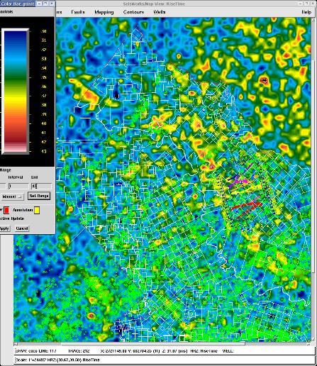
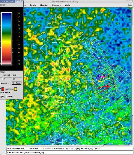
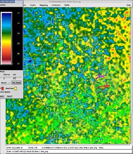
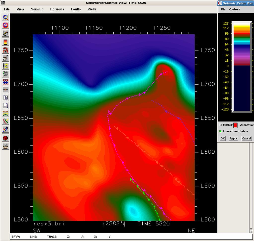
24 In-Line 580 and Trace 1165 from Louisiana 3-D seismic survey

25 Resistivity Calculations overlaid on Line 580 and Trace 1165

26 In-Line Animation of Resistivity Sections

27 Cross-Line Animation of Resistivity Cross-Sections


28 After First Pass Vertical Calibration, Time-Slice 1000 ms
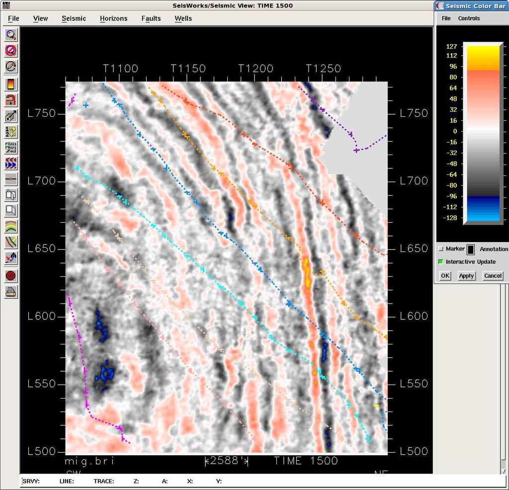
29 Resistivity-Slice on left and Seismic Time-Slice at 1500 ms on right

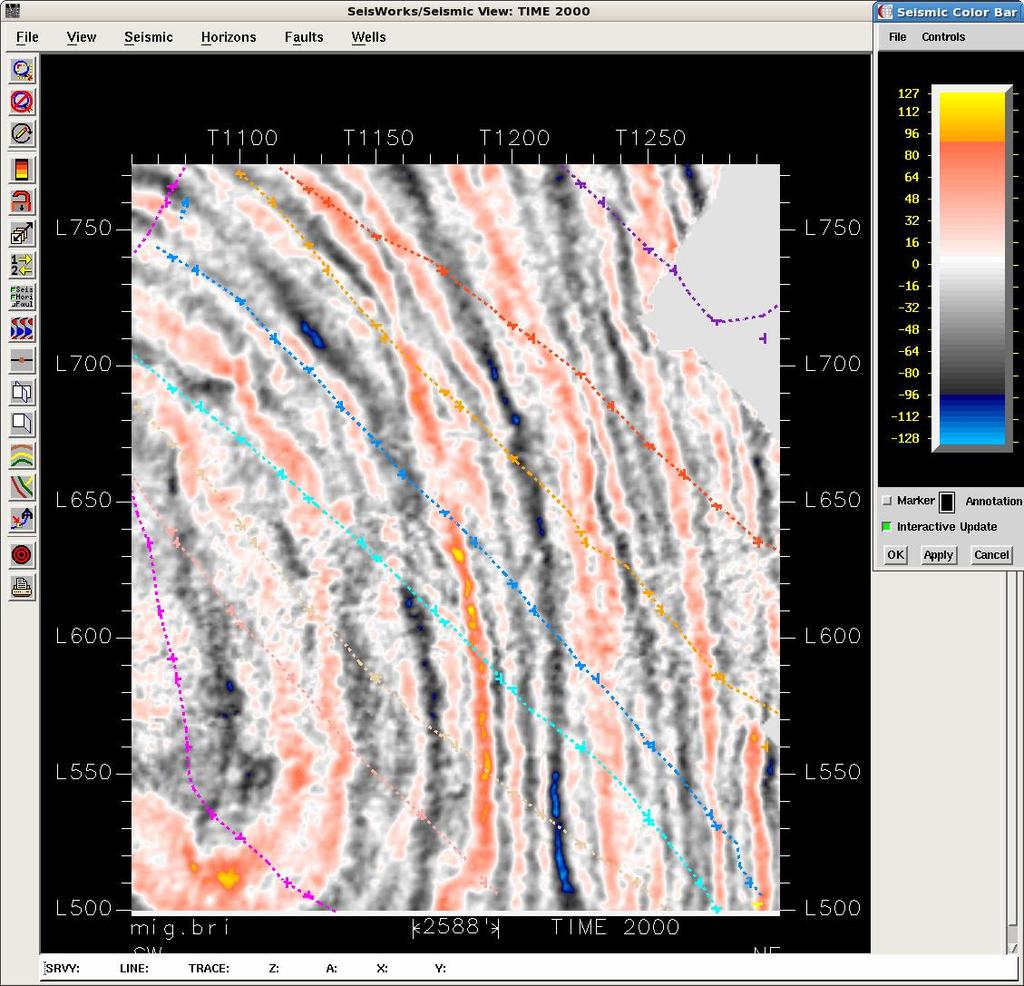
30 Resistivity-Slice on left and Seismic Time-Slice at 2000 ms on right
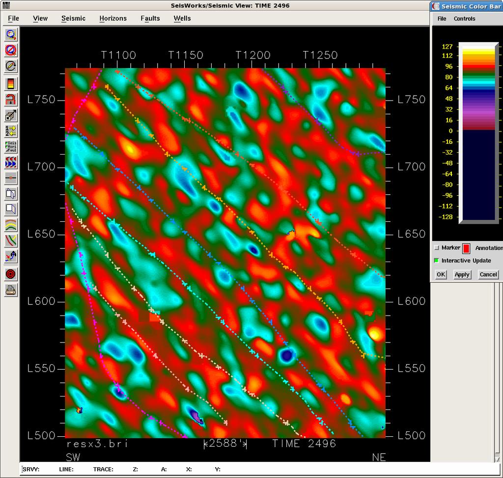
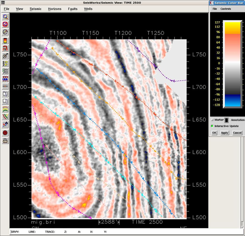
31 Resistivity-Slice on left and Seismic Time-Slice at 2500 ms on right
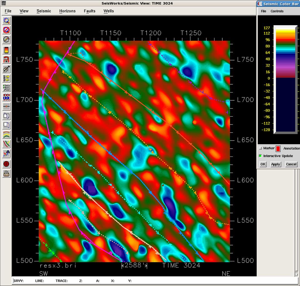
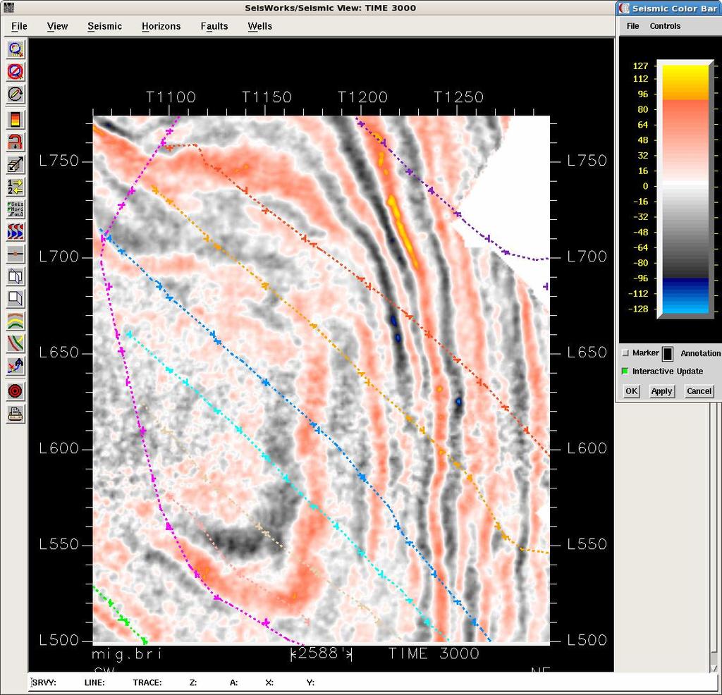
32 Resistivity-Slice on left and Seismic Time-Slice at 3000 ms on right
33 Resistivity-Slice on left and Seismic Time-Slice at 3500 ms on right
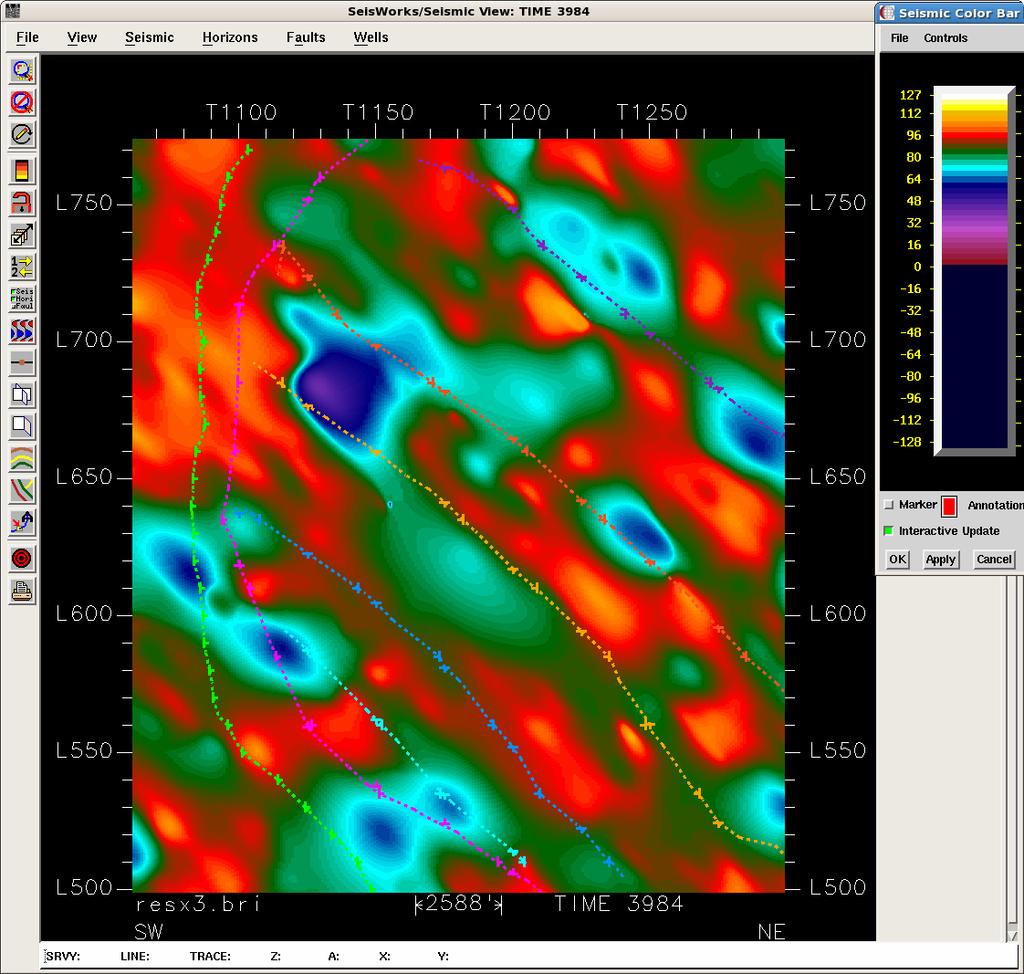
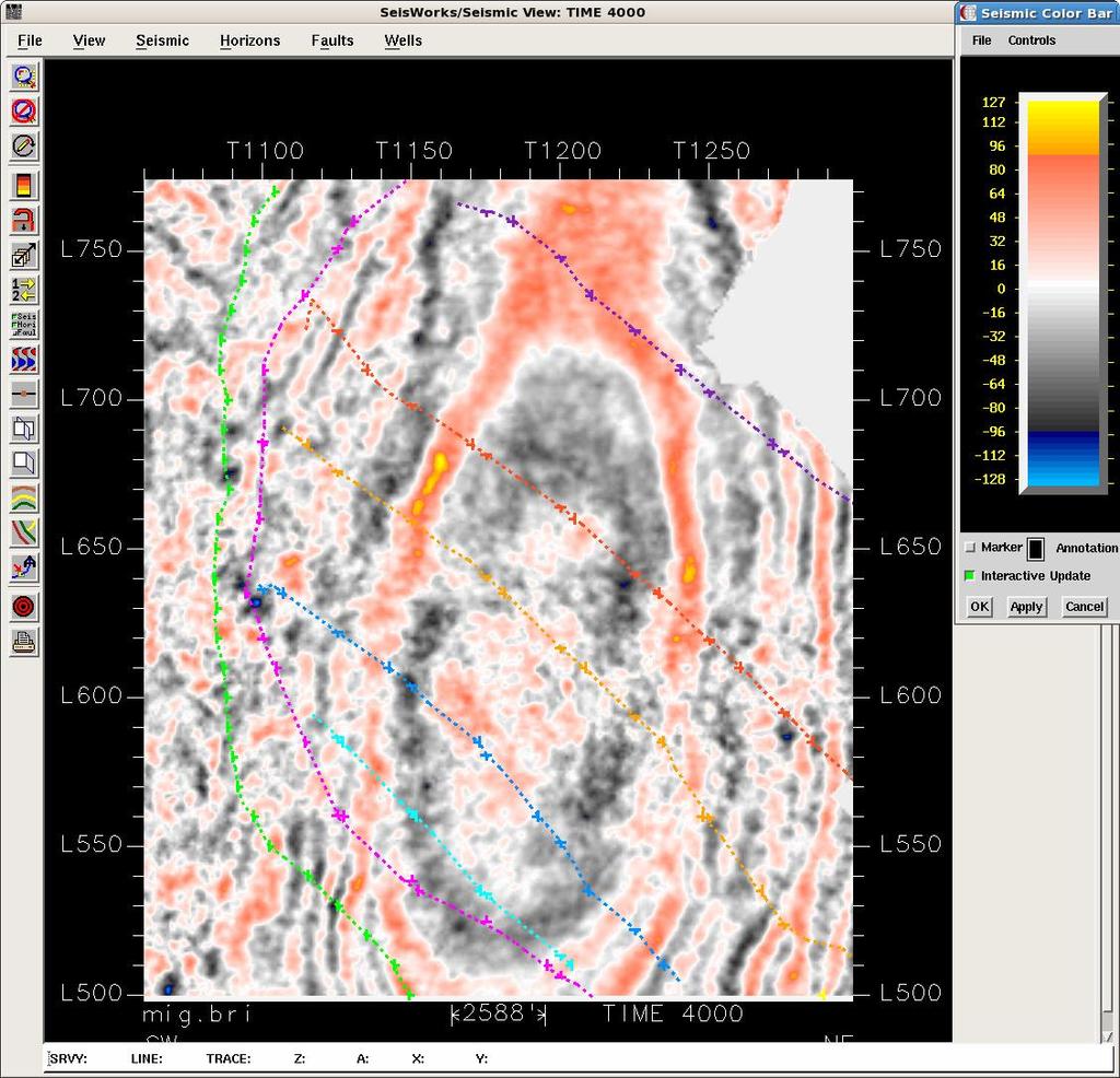
34 Resistivity-Slice on left and Seismic Time-Slice at 4000 ms on right
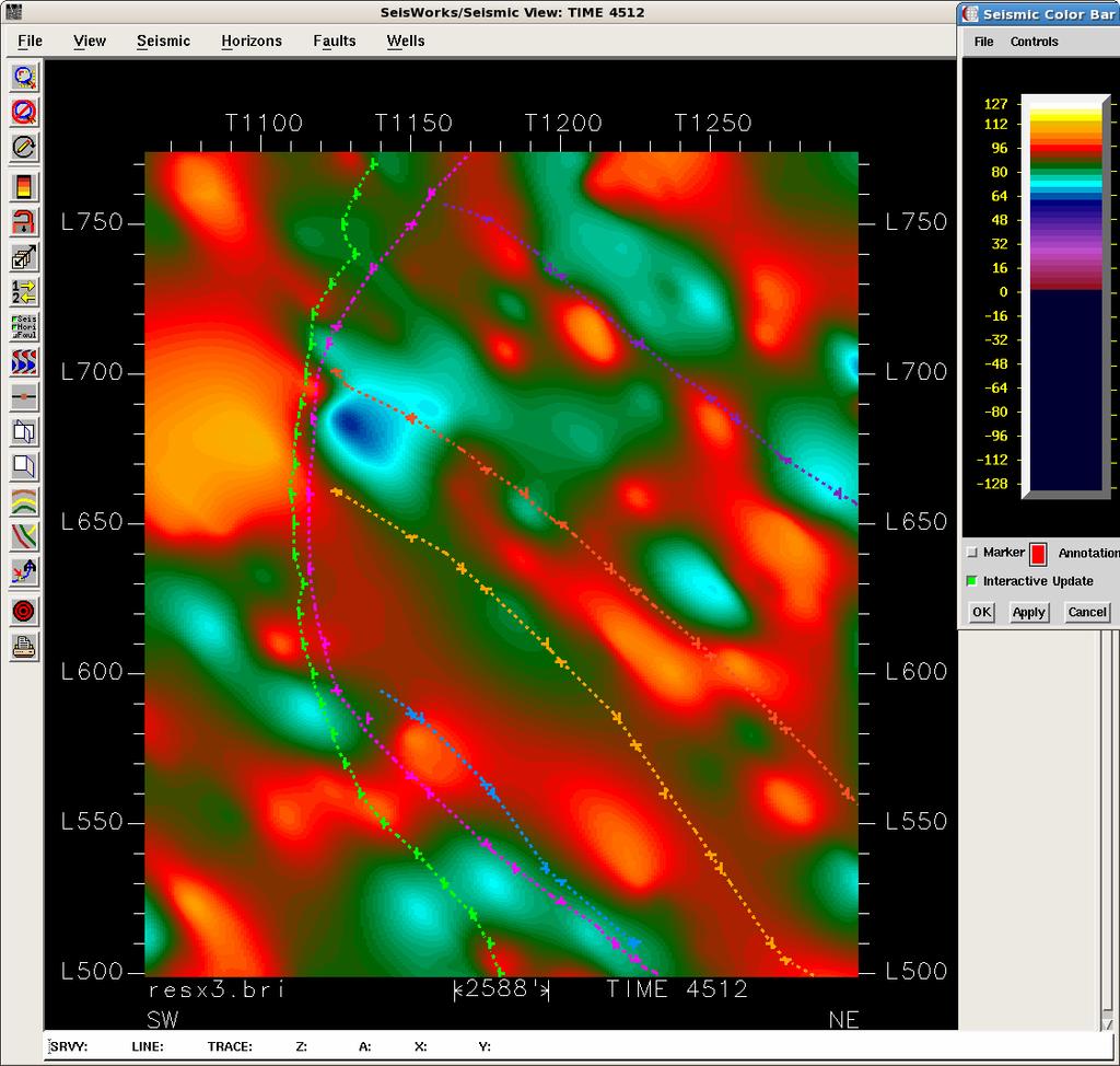
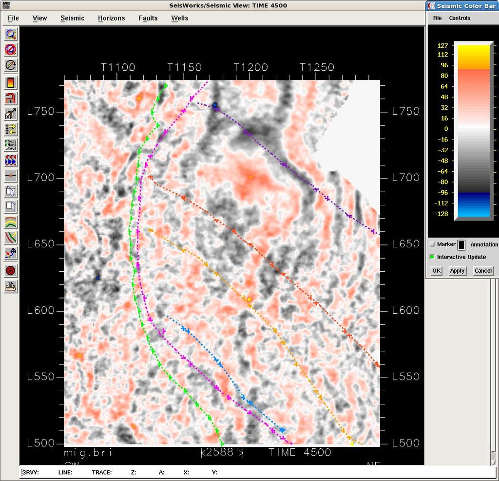
35 Resistivity-Slice on left and Seismic Time-Slice at 4500 ms on right
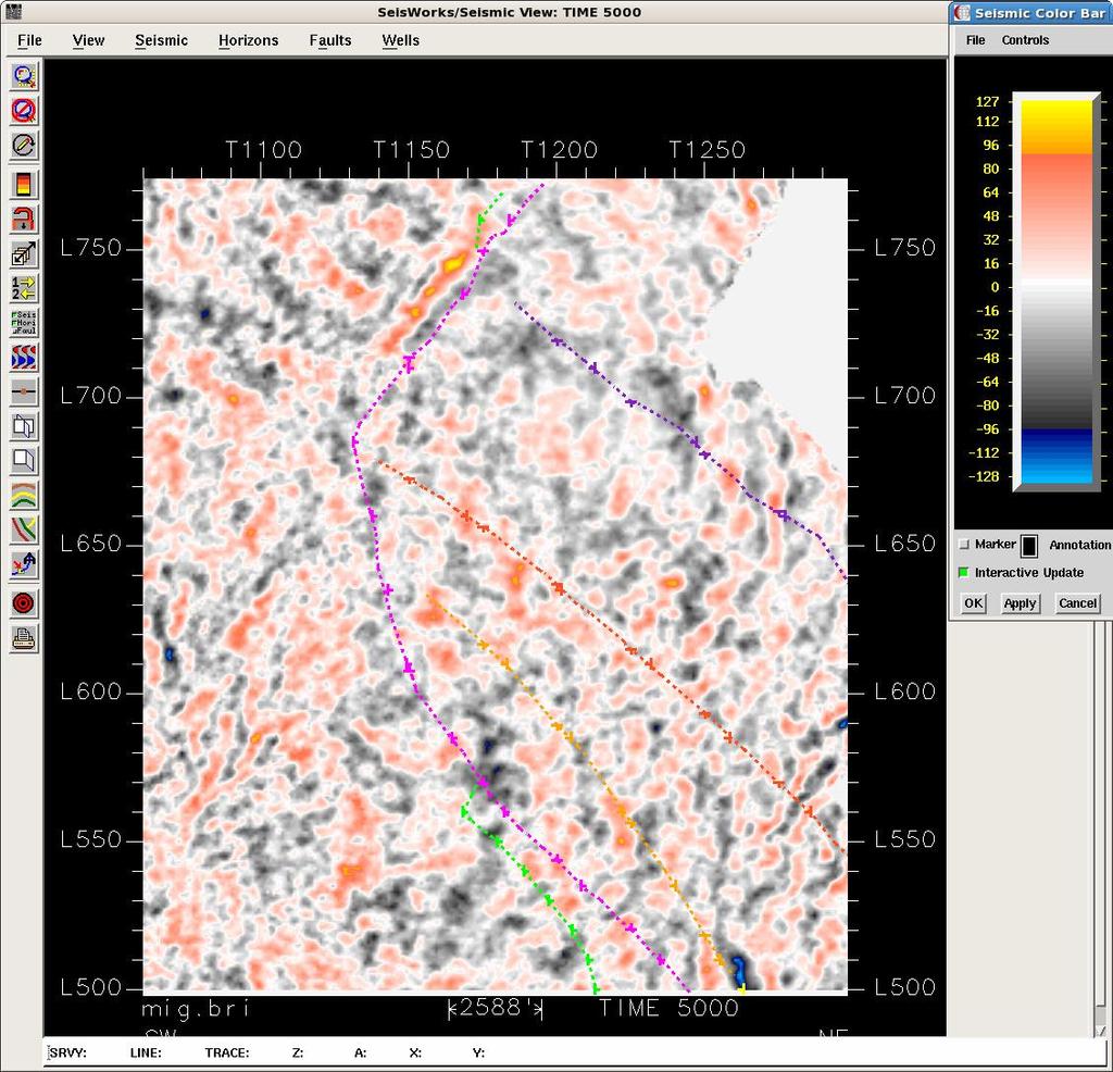
36 Resistivity-Slice on left and Seismic Time-Slice at 5000 ms on right

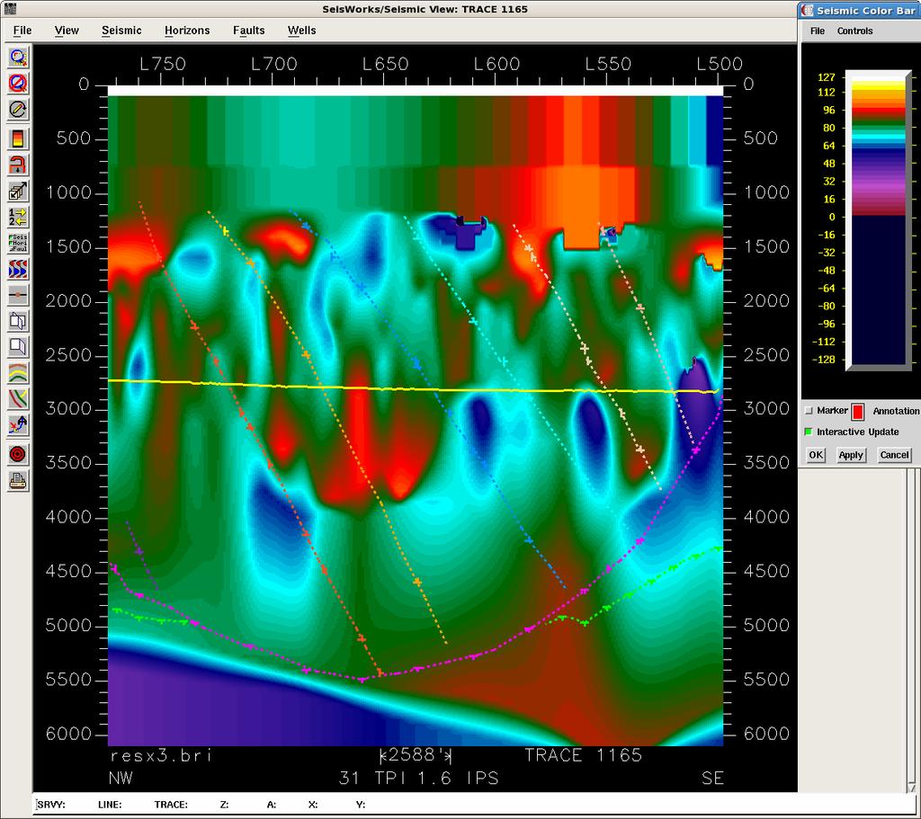

37 In-Line 580 Cross-Line 1165

38 Giant businesses are built on measuring subsurface resistivity

39 Giant businesses are built on measuring subsurface resistivity DML calculates resistivity volumes at 3-D seismic line & trace spacing


40 How this new data type can aid reservoir characterization Lightning attribute maps identify lineaments related to faulting Lightning resistivity volumes provides an independent view of geology Lightning resistivity volumes can be created to match 3-D geometry We anticipate a merger of resistivity volumes and lithology predictions from velocity volumes via Archie s equation going forward


41 The Business Value of Lightning Analysis Scenario 1 Company A has a $2 million seismic budget Where is the optimal location for new seismic? Which of the $2 million worth of spec seismic is best to purchase? Scenario 2 Company B has millions of acres of leases about to expire How do they identify and rank the sweet spots? What leases need to be retained? ANSWER: Conduct a lightning analysis

42 Summary Lighting Databases provide a new geophysical data type Data mining lightning databases is an example of innovation Lightning occurs everywhere, and databases are available Topography, vegetation, & infrastructure not primary location controls Lightning analysis works at regional, play fairway, & prospect scales Resistivity volumes are impacting 3D seismic interpretations This new data type aids reservoir characterization


43 Contact Information: H. Roice Nelson, Jr. See Lightning, cell: Dr. Jim Siebert cell: Les R. Denham cell: Think DML Baker Road #382 Barker, TX Office: West 700 South #31 Cedar City, UT Fax:
Lightning Data: the new EM seismic data
 Lightning Data: the new EM seismic data H. Roice Nelson, Jr. D. James Siebert L. R. Denham 08 November 2012 1 Electromagnetic Data maps the extent of natural resources Yellow: Red Sky 3-D seismic outline
Aquifers, Faults, Subsidence, and Lightning Databases
 Aquifers, Faults, Subsidence, and Lightning Databases K. S. Haggar, L. Denham, H.R. Nelson, Jr. Dynamic Measurement, LLC NOGS 1 OUTLINE 1. Introduction and Theory 2. Geologic Setting in Texas Study Area
Lightning Analysis: creating geo-frameworks
 Lightning Analysis: creating geo-frameworks Southern Utah Rock Club 02 March 2017 H. Roice Nelson, Jr. Dynamic Measurement LLC 02 March 2017 Copyright 2017 Southern Utah Rock Club 1 Career as geophysicist
The title of our talk is Mapping Faults and Natural Resources with Lightning Data.
 Today we introduce you to a new way to explore for natural resources. We have found that lightning strike locations are not random. They are affected by earth currents. The new approach is data mining
LIGHTNING DISCOVERIES & TECHNOLOGIES
 FEATURE OVERHEAD T&D LIGHTNING DISCOVERIES & TECHNOLOGIES How this phenomenon affects electric utilities BY JIM SIEBERT, FOX 26 Chief Meteorologist Advances in technology are helping scientists understand
Mapping Faults With Lightning, Natural-Sourced Electromagnetics (NSEM) Louis J. Berent Dynamic Measurement, LLC
 Louis J. Berent Dynamic Measurement, LLC") Mapping Faults With Lightning, Natural-Sourced Electromagnetics (NM) Louis J. Berent Dynamic Measurement, LLC 23 June 2015 Validating NM with 2-D Resistivity Imaging Profiling & Ground Penetrating Radar
Mapping Faults With Lightning, Natural-Sourced Electromagnetics (NM) Louis J. Berent Dynamic Measurement, LLC 23 June 2015 Validating NM with 2-D Resistivity Imaging Profiling & Ground Penetrating Radar
Lightning as a Geophysical Data Type
 www.dynamicmeasurement.com Lightning as a Geophysical Data Type Frequently-Asked Questions October 2014 Copyright 2014 Frequently-Asked Questions General... 4 What causes lightning?... 4 Does lightning
SEG Houston 2009 International Exposition and Annual Meeting
 The role of EM rock physics and seismic data in integrated 3D CSEM data analysis I. Brevik*, StatoilHydro, Pål T. Gabrielsen, Vestfonna and Jan Petter Morten, EMGS Summary An extensive 3D CSEM dataset
Tim Carr - West Virginia University
 Tim Carr - West Virginia University Understanding Seismic Data Resolution (Vertical and Horizontal) Common Depth Points (CDPs) Two way time (TWT) Time versus depth Interpretation of Reflectors 2 Able to
Economic Geology Unconventional Energy Research
 Bureau of Economic Geology Unconventional Energy Research Overview for CEE meeting December, 2011 QAd2349x BUREAU OF ECONOMIC GEOLOGY Oldest research unit of The University of Texas at Austin Geological
Towed Streamer EM Integrated interpretation for accurate characterization of the sub-surface. PETEX, Tuesday 15th of November 2016
 Towed Streamer EM Integrated interpretation for accurate characterization of the sub-surface. PETEX, Tuesday 15th of November 2016 Joshua May Sales and Marketing Manager Agenda Introduction to Towed Streamer
Petroleum Exploration
 Petroleum Exploration Upstream Petroleum Exploration The role of exploration is to provide the information required to exploit the best opportunities presented in the choice of areas, and to manage research
Hostile downhole conditions present complex challenges
 Haynesville Shale Hostile downhole conditions present complex challenges Solving challenges. conservative estimates show 168 trillion cubic feet of natural gas Haynesville formation The Haynesville shale
MIDDLE DEVONIAN PLAY MICHIGAN BASIN OF ONTARIO. Duncan Hamilton
 MIDDLE DEVONIAN PLAY MICHIGAN BASIN OF ONTARIO Duncan Hamilton 1 Middle Devonian Pools of the Michigan Basin 375+ Million Barrels Michigan 45+ million Barrels Ontario 2 Outline of Presentation History
ESRI GIS For Mining Seminar, 10 th August, 2016, Nairobi, Kenya. Spatial DATA Solutions for Mining
 ESRI GIS For Mining Seminar, 10 th August, 2016, Nairobi, Kenya Spatial DATA Solutions for Mining Spatial Data Solutions for Mining Spatial - Data that identifies the geographic location of features &
Profit Island Project East Baton Rouge Parish, Louisiana
 Profit Island Project Lower Tuscaloosa Play Blue Moon Exploration Company has identified and leased four excellent low risk development opportunities for substantial reserves in the Profit Island Field
PART A: Short-answer questions (50%; each worth 2%)
") PART A: Short-answer questions (50%; each worth 2%) Your answers should be brief (just a few words) and may be written on these pages if you wish. Remember to hand these pages in with your other exam pages!
PART A: Short-answer questions (50%; each worth 2%) Your answers should be brief (just a few words) and may be written on these pages if you wish. Remember to hand these pages in with your other exam pages!
OIL AND GAS PLAYS OF THE MICHIGAN BASIN, SOUTHERN ONTARIO. Terry Carter, Consulting Geologist London, Ontario
 OIL AND GAS PLAYS OF THE MICHIGAN BASIN, SOUTHERN ONTARIO Terry Carter, Consulting Geologist London, Ontario 1 Ontario Petroleum Industries Oil and Natural Gas 1250 oil wells, 1200 gas wells, annual production
Quantifying Bypassed Pay Through 4-D Post-Stack Inversion*
 Quantifying Bypassed Pay Through 4-D Post-Stack Inversion* Robert Woock 1, Sean Boerner 2 and James Gamble 1 Search and Discovery Article #40799 (2011) Posted August 12, 2011 *Adapted from oral presentation
For personal use only
 Quarterly Activities Report Quarter Ending 30 September 2018 (ASX Code: HE8) (Helios or Company) is pleased to report its activities for the quarter ended 30 September 2018. Oil Discovery in the Ojinaga
Introduction Geology
 Introduction The Wild Horse Anticline is located in the prolific Bighorn Basin of Wyoming about 5 miles northeast of the town of Basin. This structure demonstrates excellent fourway closure encompassing
An Analytic Approach to Sweetspot Mapping in the Eagle Ford Unconventional Play
 An Analytic Approach to Sweetspot Mapping in the Eagle Ford Unconventional Play Murray Roth*, Transform Software and Services, Denver, Colorado, Murray@transformsw.com Michael Roth, Transform Software
WEJCO. Exploration & Production. Eagle s Talon Prospect. The Eagle s Talon Prospect is located in south eastern Karnes County,
 WEJCO Exploration & Production Eagle s Talon Prospect The Eagle s Talon Prospect is located in south eastern Karnes County, Texas, within the new and highly prolific unconventional Eagle Ford Shale trend
Demo Schedule and Abstracts
 2014 Paradigm Technology Roadshow - Brisbane Demo Schedule and Abstracts 11 June 2014 Hilton Hotel Brisbane, Australia www.pdgm.com Location: Brisbane Time Presentation Title Featured Technologies 3:00
Lightning in Florida. Henry E. Fuelberg Department of Meteorology Florida State University
 Lightning in Florida Henry E. Fuelberg Department of Meteorology Florida State University Lightning Facts ~ 20 million cloud to ground flashes in U.S. each year Half have more than one strike point 30
Shale Capacity Key In Shale Modeling
 SEPTEMBER 213 The Better Business Publication Serving the Exploration / Drilling / Production Industry Shale Capacity Key In Shale Modeling By Ahmed Ouenes HOUSTON After more than a decade of successful
GLD360 AIRPORT LIGHTNING WARNINGS
 GLD360 AIRPORT LIGHTNING WARNINGS Ronald L. Holle and Nicholas W. S. Demetriades Vaisala Inc. Tucson, Arizona 85756 1. INTRODUCTION A comparison was made of lightning warnings for areas on the scale of
Geological Mapping using Geophysics
 Geological Mapping using Geophysics Pugin, A.J.M. and T.H. Larson Illinois State Geological Survey, 615 E Peabody Dr., Champaign, IL 61820; E-mail: A.J.M. Pugin at pugin@isgs.uiuc.edu Mapping Techniques.
Exploration _Advanced geophysical methods. Research Challenges. Séverine Pannetier-Lescoffit and Ute Mann. SINTEF Petroleum Research
 Exploration _Advanced geophysical methods * Research Challenges Séverine Pannetier-Lescoffit and Ute Mann SINTEF Petroleum Research 1 Exploration and Reservoir Characterization * Research Challenges 29%
GM 1.4. SEG/Houston 2005 Annual Meeting 639
 storage recovery project in Leyden, Colorado Kristofer Davis *, Yaoguo Li, Michael Batzle, and Bob Raynolds** Center for Gravity, Electrical, and Magnetic Studies, Department of Geophysics, Colorado School
Exploration research at SINTEF Petroleum
 Joining Forces 2016, Stavanger 2 nd and 3 rd of February 2016 Exploration research at SINTEF Petroleum Ane Lothe Research Manager, Basin Modelling Group Technology for a better society 1 Overview Short
Electromagnetic Imaging (EMI) Representative Project Summaries
 Representative Project Summaries") Electromagnetic Imaging (EMI) Representative Project Summaries A Cost-Effective Tool for Site Characterization Marcellus Shale Water Group, LLC State College, PA Houston, TX Austin, TX Scanning the brain,
Electromagnetic Imaging (EMI) Representative Project Summaries A Cost-Effective Tool for Site Characterization Marcellus Shale Water Group, LLC State College, PA Houston, TX Austin, TX Scanning the brain,
Vaisala s NLDN U.S. National Lightning Detection Network
 Vaisala s NLDN U.S. National Lightning Detection Network / Scientific Accuracy. Proven Reliability. Setting the Standard for Accuracy and Reliability. Lightning information you can trust Vaisala s NLDN
THE DEEPENING OF A LOW-LEVEL TROUGH AS INDICATED BY DUST ALOFT IN GOES ' INFRARED PICTURES
 REFERENCES Baughman, R. G., and C. W. Schmid, Jr.: Lightning Storm Characteristics. U.S. Service, Intermountain Forest and Range ment Station, Research Paper in press. Davis, L. S., and R. W. Cooper, 1963:
FRIO BRINE SEQUESTRATION PILOT IN THE TEXAS GULF COAST
 I1-2 FRIO BRINE SEQUESTRATION PILOT IN THE TEXAS GULF COAST Susan D. Hovorka and Paul R. Knox Bureau of Economic Geology, John A. and Katherine G. Jackson School of Geosciences, The University of Texas
Modeling Optimizes Asset Performance By Chad Baillie
 MARCH 2016 The Better Business Publication Serving the Exploration / Drilling / Production Industry Modeling Optimizes Asset Performance By Chad Baillie MISSOURI CITY, TX. As more well and completion data
Seismoelectric Ground-flow DC-4500 Locator
 Seismoelectric Ground-flow DC-4500 Locator Introduction The seismoelectric survey is a new technology combined the electro kinetic potential method and geophysical technology. It is applied directly to
Grade Levels: minutes AMBROSE VIDEO PUBLISHING 1996
 #3628 LIGHTNING Grade Levels: 4-12 30 minutes AMBROSE VIDEO PUBLISHING 1996 DESCRIPTION Lightning is a very familiar natural force, but scientists don't know how it begins, what causes it, or why a bolt
GEOL4714 Final Exam Fall 2005, C. H. Jones instructor
 GEOL4714 Final Exam Fall 2005 p. 1 GEOL4714 Final Exam Fall 2005, C. H. Jones instructor Name: Student ID #: Feel free to use the back of the sheets for answers needing more space. (1) (10 pts) For each
Liberty Petroleum Corporation. Liberty Petroleum Corporation L-12-5 Review
 Liberty Petroleum Corporation L-12-5 Liberty Petroleum Corporation Western Australia Officer Basin Location: Officer Basin Australia Block size: 5,600,000 Acres Operator: Liberty chosen as preferred explorer,
Hazard Mapping Along the Dead Sea Shoreline
 FIG Working Week in Marrakech, Morocco 18-22 May 2011 Hazard Mapping Along the Dead Sea Shoreline Rami Al-Ruzouq, Abdullah Al-Zuobi, AbdEl-Rahman Abueladas, Emad Akkawi Department of Surveying and Geomatics
EXAMINER S REPORT AND RECOMMENDATION STATEMENT OF THE CASE
 OIL AND GAS DOCKET NO. 08-0248239 THE APPLICATION OF PETRO-HUNT, L.L.C. TO CONSIDER NEW FIELD DESIGNATION AND FIELD RULES FOR THE (PROPOSED) TOYAH, NW (SHALE) FIELD, REEVES COUNTY, TEXAS Heard by: Donna
Stratimagic. Seismic Facies Classification
 Stratimagic Seismic Facies Classification 1 Stratimagic A truly geological interpretation of seismic data Stratimagic seismic facies maps allow geoscientists to rapidly gain insight into the depositional
Assessing our untapped energy resources. Derek Reay Geological Survey of Northern Ireland
 Assessing our untapped energy resources Derek Reay Geological Survey of Northern Ireland Talk Outline Northern Ireland energy market Oil and Gas Exploration Description Exploration risks Application of
Downloaded 01/29/13 to Redistribution subject to SEG license or copyright; see Terms of Use at
 An integrated study of a Mississippian tripolitic chert reservoir Osage County, Oklahoma, USA Benjamin L. Dowdell*, Atish Roy, and Kurt J. Marfurt, The University of Oklahoma Summary With the advent of
National Weather Service Morristown, Tennessee Lightning and Weather - What Every Trail Rider Needs to Know to Protect Themselves
 National Weather Service Morristown, Tennessee Lightning and Weather - What Every Trail Rider Needs to Know to Protect Themselves by David Gaffin Senior Forecaster Lightning Nature s Awesome Power Lightning
Unique Vaisala Global Lightning Dataset GLD360 TM
 Unique Vaisala Global Lightning Dataset GLD360 TM / THE ONLY LIGHTNING DETECTION NETWORK CAPABLE OF DELIVERING SUCH HIGH-QUALITY DATA ANYWHERE IN THE WORLD GLD360 provides high-quality lightning data anywhere
Unique Vaisala Global Lightning Dataset GLD360 TM
 Unique Vaisala Global Lightning Dataset GLD360 TM / THE ONLY LIGHTNING DETECTION NETWORK CAPABLE OF DELIVERING HIGH-QUALITY DATA ANYWHERE IN THE WORLD GLD360 provides high-quality lightning data anywhere
MT Prospecting. Map Resistivity. Determine Formations. Determine Structure. Targeted Drilling
 MT Prospecting Map Resistivity Determine Formations Determine Structure Targeted Drilling Cross-sectional interpretation before and after an MT survey of a mineral exploration prospect containing volcanic
Seismic Attributes and Their Applications in Seismic Geomorphology
 Academic article Seismic Attributes and Their Applications in Seismic Geomorphology Sanhasuk Koson, Piyaphong Chenrai* and Montri Choowong Department of Geology, Faculty of Science, Chulalongkorn University,
Raster Data Enhancement and Tectonic Element Interpretation in ArcMap
 Raster Data Enhancement and Tectonic Element Interpretation in ArcMap Vsevolod Egorov ESRI Petroleum User Group Conference Houston, TX 2005 Abstract ArcMap Spatial Analyst provides quick, but powerful
Osareni C. Ogiesoba 1. Search and Discovery Article #10601 (2014)** Posted May 31, 2014
** Posted May 31, 2014") Seismic Multiattribute Analysis for Shale Gas/Oil within the Austin Chalk and Eagle Ford Shale in a Submarine Volcanic Terrain, Maverick Basin, South Texas* Osareni C. Ogiesoba 1 Search and Discovery Article
Seismic Multiattribute Analysis for Shale Gas/Oil within the Austin Chalk and Eagle Ford Shale in a Submarine Volcanic Terrain, Maverick Basin, South Texas* Osareni C. Ogiesoba 1 Search and Discovery Article
Vaisala s NLDN and GLD360 performance improvements and aviation applications. Nick Demetriades Head of Airports Vaisala 2015 Fall FPAW
 Vaisala s NLDN and GLD360 performance improvements and aviation applications Nick Demetriades Head of Airports Vaisala 2015 Fall FPAW Introduction Continuous CONUS Data Since 1989 The U.S. National Lightning
The Gulf of Mexico - From Various Vantage Points John E. Bain, Kenton J. Hamilton
 The Gulf of Mexico - From Various Vantage Points John E. Bain, Kenton J. Hamilton Oftentimes in exploration geophysics we tend to focus on specific near-term exploration prospects, as dictated by the current
National Geophysical Survey Science Opportunities
 National Geophysical Survey Science Opportunities Anton Ziolkowski Professor of Petroleum Geoscience University of Edinburgh BGS Keyworth 4 April 2016 Outline Brief biography Science opportunities High
Seismic characterization of Montney shale formation using Passey s approach
 Seismic characterization of Montney shale formation using Passey s approach Ritesh Kumar Sharma*, Satinder Chopra and Amit Kumar Ray Arcis Seismic Solutions, Calgary Summary Seismic characterization of
Environmental & Research Report: SLFPA-W board meeting August 24, 2016 Presented by Mr. Merritt
 Environmental & Research Report: SLFPA-W board meeting August 24, 2016 Presented by Mr. Merritt We need this. You are responsible for a huge flood protection system including the world's largest pump
Seismic Geomorphology and Analysis of the Ordovician Paleokarst Drainage System in the Central Tabei Uplift, Northern Tarim Basin, Western China*
 Seismic Geomorphology and Analysis of the Ordovician Paleokarst Drainage System in the Central Tabei Uplift, Northern Tarim Basin, Western China* Hongliu Zeng 1, Robert Loucks 1, Xavier Janson 1, Quizhong
Moroccan lightning detection network, topology, performance and management of the network
 Moroccan lightning detection network, topology, performance and management of the network Mohamed DAHOUI, Mohamed NBOU and Rabia MERROUCHI Moroccan Meteorological Center Tel (212)71302837, Fax: (212)22908593
Magnitude 6.9 GULF OF CALIFORNIA
 A pair of strong earthquakes struck off the coast of Mexico early Thursday only minutes apart. The magnitude 6.9 and 6.2 were centered about 85 miles northeast of Guerrero Negro in the Mexican state of
Sequence Stratigraphy of the Upper Cretaceous Niobrara Formation, A Bench, Wattenberg Field, Denver Julesburg Basin, Colorado*
 Sequence Stratigraphy of the Upper Cretaceous Niobrara Formation, A Bench, Wattenberg Field, Denver Julesburg Basin, Colorado* Lisa E. Remington LaChance 1 and Mark C. Robinson 1 Search and Discovery Article
For personal use only
 Listed on the Australian Securities Exchange ( AKK ) and the OTC-QX International in the USA (AUN-XY) ACN 114 198 471 ASX ANNOUNCEMENT 1 May 2014 Drilling operations underway for 1 st Pierre oil well in
Integrated well log and 3-D seismic data interpretation for the Kakinada area of KG PG offshore basin
 IOSR Journal of Applied Geology and Geophysics (IOSR-JAGG) e-issn: 2321 0990, p-issn: 2321 0982.Volume 5, Issue 4 Ver. II (Jul. Aug. 2017), PP 01-05 www.iosrjournals.org Integrated well log and 3-D seismic
BIOGEOCHEMISTRY Discovery Using Metal Concentrations in Plants
 1 BIOGEOCHEMISTRY Discovery Using Metal Concentrations in Plants Shea Clark Smith Minerals Exploration & Environmental Geochemistry P.O. Box 18325 Reno, Nevada 89511 Tel: 775-849-2235 Fax: 775-849-2335
MITIGATE RISK, ENHANCE RECOVERY Seismically-Constrained Multivariate Analysis Optimizes Development, Increases EUR in Unconventional Plays
 White Paper MITIGATE RISK, ENHANCE RECOVERY Seismically-Constrained Multivariate Analysis Optimizes Development, Increases EUR in Unconventional Plays SM Seismically-Constrained Multivariate Analysis Optimizes
G002 An Integrated Regional Framework for Seismic Depth Imaging in the Deepwater Gulf of Mexico
 G002 An Integrated Regional Framework for Seismic Depth Imaging in the Deepwater Gulf of Mexico M. Davidson (Fugro Multi Client Services), M. Leander (Fugro Multi Client Services), K. Mohn (Fugro Multi
Vaisala Blitzdetektion. Michael Kalkum
 Vaisala Blitzdetektion Michael Kalkum 12.11.2013 What Is Lightning? Lightning is a transient, high-current electrical discharge Lightning stroke is typically 30.000 C Lightning takes the path of least
Earthquake Hazards. Tsunami
 Earthquake Hazards Tsunami Review: What is an earthquake? Earthquake is the vibration (shaking) and/or displacement of the ground produced by the sudden release of energy. The point inside the Earth where
Earthquake Hazards. Tsunami
 Earthquake Hazards Tsunami Measuring Earthquakes Two measurements that describe the power or strength of an earthquake are: Intensity a measure of the degree of earthquake shaking at a given locale based
Ground-Water Exploration in the Worthington Area of Nobles County: Summary of Seismic Data and Recent Test Drilling Results
 Ground-Water Exploration in the Worthington Area of Nobles County: Summary of Seismic Data and Recent Test Drilling Results Jim Berg and Todd Petersen Geophysicists, DNR Waters January 2000 Table of Contents
Airborne gravity gradiometer surveying of petroleum systems under Lake Tanganyika, Tanzania
 Airborne gravity gradiometer surveying of petroleum systems under Lake Tanganyika, Tanzania D. Roberts Beach Energy P. Roy Chowdhury CGG S. J. Lowe CGG A. N. Christensen CGG Outline Introduction Geology
Reducing Uncertainty through Multi-Measurement Integration: from Regional to Reservoir scale
 Reducing Uncertainty through Multi-Measurement Integration: from Regional to Reservoir scale Efthimios Tartaras Data Processing & Modeling Manager, Integrated Electromagnetics CoE, Schlumberger Geosolutions
Oil and Gas Mineral Interest For Sale 2,145 acres in Cotton Valley/Hosston Sligo/Edwards Trend Exploration Trend
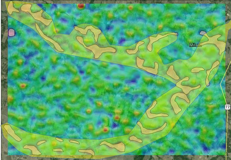
 Oil and Gas Mineral Interest For Sale 2,145 acres in Cotton Valley/Hosston Sligo/Edwards Trend Exploration Trend Milam County, Texas Fee Mineral interest is located in shallow oilfield discovered in 1940
Working Interest Kris Kon #2-Project Deal
 Working Interest Kris Kon #2-Project Deal Page 1 of 10 Kris Kon #2-Project Deal October 2016 Project provider Project name Geographical area Formation/Primary targets Type of wells Number of wells Expected
Ramani Geosystems. Putting Africa On The Map. Authorized Resellers
 Ramani Geosystems Putting Africa On The Map Authorized Resellers Ramani Profile Started in 1999 Aerial, Land Surveying & Mapping Solutions + 10 Countries in the region + 80 Staff working in projects Asset
Although most karstic regions
 Urban Geophysics: Geophysical Signature of Mount Bonnell Fault and Its Karstic Features in Austin, TX by Mustafa Saribudak, Environmental Geophysics Associates, Austin, TX Although most karstic regions
Geophysical Exploration in Water Resources Assessment. John Mundell, P.E., L.P.G., P.G. Ryan Brumbaugh, L.P.G. Mundell & Associates, Inc.
 Geophysical Exploration in Water Resources Assessment John Mundell, P.E., L.P.G., P.G. Ryan Brumbaugh, L.P.G. Mundell & Associates, Inc. Presentation Objective Introduce the use of geophysical survey methods
Electrical thunderstorm nowcasting using lightning data mining
 Data Mining VII: Data, Text and Web Mining and their Business Applications 161 Electrical thunderstorm nowcasting using lightning data mining C. A. M. Vasconcellos 1, C. L. Curotto 2, C. Benetti 1, F.
Geophysical model response in a shale gas
 Geophysical model response in a shale gas Dhananjay Kumar and G. Michael Hoversten Chevron USA Inc. Abstract Shale gas is an important asset now. The production from unconventional reservoir like shale
Cretaceous, Dakota Formation, Terra Cotta Member South Side of I-70, Salina County, Kansas
 Cretaceous, Dakota Formation, Terra Cotta Member South Side of I-70, Salina County, Kansas Written By: Steven D.J. Baumann G-102010-1A Outcrop looking southeast Photo taken by: Steven Baumann on 10-20-2010
MARKET UPDATE ON URANIUM AND GOLD PROJECTS
 ASX Announcement 1 March 2011 MARKET UPDATE ON URANIUM AND GOLD PROJECTS HIGHLIGHTS 5,000 metre drilling programme to commence at Rio Puerco uranium project within the next two weeks. Drilling to commence
W. MICHAEL CLINE CONSULTING GEOPHYSICIST. T/X RESOURCES Combining Technology with Petroleum EXploration Since 1985
 T/X RESOURCES Combining Technology with Petroleum EXploration Since 1985 Introduction: I am a technically-oriented Geophysicist, with extensive seismic interpretation/reservoir analysis experience, who
For personal use only
 28 May 2012 Farm Out Arrangements Turner Bayou Project Pryme Energy Limited (Pryme) and its partners in the Turner Bayou project have established arrangements for farming out of a portion of their project
Seismic Inversion on 3D Data of Bassein Field, India
 5th Conference & Exposition on Petroleum Geophysics, Hyderabad-2004, India PP 526-532 Seismic Inversion on 3D Data of Bassein Field, India K.Sridhar, A.A.K.Sundaram, V.B.G.Tilak & Shyam Mohan Institute
L.S. Lee* Hong Kong Observatory, Hong Kong, China
 2.5 COMPREHENSIVE AND LOCATION-SPECIFIC LIGHTNING INFORMATION SERVICE IN HONG KONG L.S. Lee* Hong Kong Observatory, Hong Kong, China 1. INTRODUCTION The Hong Kong Observatory (HKO) set up a lightning location
Understanding Water Level Transducers. Texas Groundwater Summit San Antonio, TX 2018
 Understanding Water Level Transducers Texas Groundwater Summit San Antonio, TX 2018 Presented by Raymond L Straub Jr., P.G. Raymond L Straub Jr., P.G. Licensed Professional Geoscientist President of Straub
Lightning Safety in a Flash / VAISALA AIRPORT LIGHTNING INFORMATION SYSTEM (ALIS)
") Lightning Safety in a Flash / VAISALA AIRPORT LIGHTNING INFORMATION SYSTEM (ALIS) Global Threat to Airports Proven. Global. The Vaisala Airport Lightning Information System (ALIS) opens a new era of universal
Lightning Safety in a Flash / VAISALA AIRPORT LIGHTNING INFORMATION SYSTEM (ALIS) Global Threat to Airports Proven. Global. The Vaisala Airport Lightning Information System (ALIS) opens a new era of universal
ADDENDA #1 CONTRACT # C May 3, 2013 Page 1 of 1
 State of California Natural Resources Agency Edmund G. Brown Jr., Governor DEPARTMENT OF PARKS AND RECREATION Major General Anthony L. Jackson, USMC (Ret), Director ADDENDA #1 CONTRACT # C1247040 May 3,
Experienced specialists providing consulting services worldwide. Coalbed Methane Consulting Services
 Experienced specialists providing consulting services worldwide Coalbed Methane Consulting Services Proven technical leadership Schlumberger is a world leader in coalbed methane (CBM) engineering and geosciences.
Integration of Surface Seismic Data with Geo-electric Data
 Integration of Surface Seismic Data with Geo-electric Data ABDULRAHMAN AL-SHUHAIL Earth Sciences Department King Fahd Univesity of Petroleum & Minerals. SAUDI ARABIA s234817@kfupm.edu.sa Abstract: - The
2011 SEG SEG San Antonio 2011 Annual Meeting 771. Summary. Method
 Geological Parameters Effecting Controlled-Source Electromagnetic Feasibility: A North Sea Sand Reservoir Example Michelle Ellis and Robert Keirstead, RSI Summary Seismic and electromagnetic data measure
UNCONVENTIONAL RESERVOIR ASSESSMENT USING MUDLOGGING
 UNCONVENTIONAL RESERVOIR ASSESSMENT USING MUDLOGGING Bill Donovan Donovan Brothers Incorporated/Automated Mudlogging Systems March 20, 2018 DENVER WELL LOGGING SOCIETY Denver, CO Unconventional Reservoir
An integrated study of fracture detection using P-wave seismic data
 An integrated study of fracture detection using P-wave seismic data Yungui Xu 1, 2, An Yong 3, Xiang-Yang Li 1,2,3, Cao Zhenglin 4 1 British Geological Survey, Murchison House, West Mains Road, Edinburgh
GEO 105 Oil and Gas Exploration Project
 GEO 105 Oil and Gas Exploration Project Modified from: Friedman, G.M., Johnson, K.G., 1982, Exercises in Sedimentology, John Wiley, p. 208 (via Reames and Carrigan at Olivet University) Student Learning
Barnett Shale-Woodford Shale play of the Delaware basin is it another giant shale gas field in Texas?
 Barnett Shale-Woodford Shale play of the Delaware basin is it another giant shale gas field in Texas? Bob Cluff The Discovery Group, Inc Denver, Colorado, USA bobcluff@discovery-group.com Delaware basin
Block 43B - Onshore Oman
 Block 43B - Onshore Oman SUMMARY Block 43B is an 11,967 km 2 area located along the coastal area of Oman north of the Hajar Mountains. This is an unexplored region, both geographically and stratigraphically.
Geophysical Case studies From Texas
 Geophysical Case studies From Texas 1 PRESENTATION OUTLINE Active Growth Faults in Metropolitan Houston 1. Hockley 2. Tomball 3. Long Point 4. Pearland Foundation Case Studies Karst Geophysics in Austin:
Introduction to Formation Evaluation Abiodun Matthew Amao
 Introduction to Formation Evaluation By Abiodun Matthew Amao Monday, September 09, 2013 Well Logging PGE 492 1 Lecture Outline What is formation evaluation? Why do we evaluate formation? What do we evaluate?
Earthquake Hazards. Tsunami
 Earthquake Hazards Tsunami Review: What is an earthquake? Earthquake is the vibration (shaking) and/or displacement of the ground produced by the sudden release of energy. The point inside the Earth where
Subsurface Geology and Resource Exploration
 LAB 11. Subsurface Geology and Resource Exploration Locating earth resources such as aluminum, copper, gold and gemstones has been an important job for geologists for a long time. This lab deals with the