A subducted oceanic ridge influencing the Nankai megathrust earthquake rupture
|
|
|
- Gilbert Wilkerson
- 6 years ago
- Views:
Transcription
1 FRONTIER RESEARCH ON EARTH EVOLUTION, VOL. A subducted oceanic ridge influencing the Nankai megathrust earthquake rupture Jin-Oh Park Research Program for Plate Dynamics, Institute for Research on Earth Evolution (IFREE). Introduction The Nankai subduction zone may be divided into four discrete domains (A through D, Fig. ) marked by the megathrust earthquake rupture [Ando, 9], each of which roughly corresponds to a geologically well-defined forearc basin [Sugiyama, 99]. The two discrete domains (C and D) of the eastern Nankai (Fig. ) are often referred to as Tonankai and Tokai segments, respectively. The Zenisu ridge (Fig. ), presumed to be an old volcanic ridge at the western flank of the Izu-Bonin arc with overprinted crustal shortening [Lallemant et al., 99; Ishizuka et al., 99], is suggested to be one of the major structures associated with subduction processes in the Tokai segment [Le Pichon et al., 99]. Also, the presence of a subducted ridge (referred to as paleo- Zenisu) north of the current Zenisu ridge has been proposed by seafloor morphologic [Lallemand et al., 99; Okino and Kato, 99] and geomagnetic anomaly data [Le Pichon et al., 99]. Although there have been few seismic reflection images to clearly demonstrate the paleo-zenisu ridge, it was suggested that the ridge is presently located on top of the main décollement immediately adjacent to the backstop and its subduction below the Tokai margin has led to a reorganization of the margin with a sequence of uplift, erosion, and growth of a new accretionary wedge [Le Pichon et al., 99]. In order to determine the crustal structure of the eastern Nankai subduction zone, we have carried out extensive seismic surveys since 99. We present new multichannel seismic (MCS) reflection profiles and an Ocean Bottom Seismograph (OBS) wide-angle seismic profile, which reveal a subducted oceanic ridge immediately beneath the eastern Nankai accretionary wedge. In this paper, we describe the structural features related to the ridge subduction and demonstrate its seismotectonic implication.. Seismic survey data and interpretation We conducted detailed MCS surveys in the eastern Nankai Trough subduction zone, using R/V Kairei of the Japan Marine Science and Technology Center (JAMSTEC). On profile D (Fig. ) crossing the Nankai Trough, a strong reflection from oceanic crust of the PSP is continuously traceable at least km landward from the frontal thrust (FT), as the PSP subducts beneath the forearc accretionary wedge of Tertiary-Quaternary geologic age [e.g., Okuda, 9]. A clear décollement reflection is observed at least km landward from the FT. This profile reveals an oceanic basement high on the subducting PSP beneath the accretionary wedge at ~- km distance. The peak of the basement high is located apparently seaward of the outer ridge (~ km distance). Maximum height of the basement high is estimated to be ~. km, based on the averaged P-wave interval velocity (Vp) of ~. km/s around the basement high, which is derived from the MCS stacking velocity (this study) and wide-angle velocity of the adjacent OBS/MCS line KR9 [Nakanishi et al., ]. The base of the basement high is about km wide. A pronounced reflector (hereafter, referred to as R ) is observed at ~ sec two-way time (TWT) at ~- km distance. The almost horizontal reflector R is confined to the area just below the forearc basin covered by well-stratified sedimentary sequences. Compared with the adjacent OBS/MCS line KR9 [Nakanishi et al., ], the reflector R is roughly coincident with the topmost surface of seaward edge of the backstop that is mainly composed of Cretaceous- Tertiary accreted sediments. A similar basement high is also identified on other MCS profiles on dip lines D, KR9, D, D9,, and D. Not surprisingly, we also identify the oceanic basement high on strike profile S (Fig. ), which intersects all of the dip lines D through D. The topmost reflector of the oceanic crust is continuously observed over the entire line. This profile clearly exhibits a similar oceanic basement high at ~- km distance. On the whole, the décollement reflection is not continuous above the basement high, except for its western flank. This basement high with an irregular surface is similarly estimated to be ~. km high in maximum and ~ km long on this profile. As a result, several MCS profiles in the Tonankai segment reveal a buried elongate oceanic basement high on dip and strike lines, which subducts immediately beneath the accretionary wedge. We interpret this basement high as a trough-parallel subducted oceanic ridge attached to the descending PSP. A combined OBS/MCS survey on line TKY (Fig. ) imaged a double ridge (hereafter, referred to as south and north ridges) subducting beneath the forearc accretionary wedge, which were estimated to be ~ km and ~ km wide, respectively (see Kodaira et al. [] for detailed data acquisition and processing procedure). Particularly, the south ridge at the inner slope region almost coincides with the paleo-zenisu ridge distribution (Fig. ) that was suggested by the magnetic anomaly data [Le Pichon et al., 99].. Discussion: new ridge distribution and the possible impact on the 9 Tonankai earthquake rupture The magnetic anomaly signature [Le Pichon et al., 99] that was used to show the distribution of paleo-zenisu ridge, may help to infer the connection between the subducted Tonankai ridge and the subducted Tokai south ridge. The combination of the MCS images in the Tonankai segment, the OBS/MCS result showing the subducted south ridge [Kodaira et al, ] in the Tokai segment, and the magnetic data, we infer a spatial distribution of the elongate, trough-parallel subducted ridge in the eastern Nankai, as seen in Figure. As a result, our new seismic reflection and refraction data confirm the existence of the paleo-zenisu ridge, and moreover, expands its distribution to the west. The subducted ridge is located spanning roughly both the outer ridge region in
2 FRONTIER RESEARCH ON EARTH EVOLUTION, VOL. the Tonankai segment and the inner slope region in the Tokai segment. The ridge is estimated to be a maximum of ~. km high, ~- km wide, and ~ km long, which is similar to the current Zenisu ridge. Lateral diversity of the ridge height along the strike (e.g., line S in Fig. ) allows us to infer that it may be a complex of closely spaced isolated seamounts just like the current Zenisu ridge, rather than a uniformly elongate body with the same height. The spatial distribution of the subducted ridge (Fig. ) suggests that the ridge is located roughly at the seaward edge of the coseismic rupture zone of the 9 Tonankai earthquake. The ridge does not extend west beyond MCS line D. Instead, the coseismic rupture along the splay fault appears to have propagated farther seaward at the region (Fig. ), for example, on line (Fig. ). Combining the MCS data (reflector R on line D) with the wideangle OBS velocity structure on adjacent line KR9 [Nakanishi et al., ], the trough-parallel subducted ridge appears to be in close contact with the seaward end of the rigid backstop (Vp > km/s) in the Tonankai segment (Fig. ), leading us to speculate that there is strong mechanical coupling due to ridge-backstop collision in the segment. A numerical simulation result [Baba et al., ] indicates that tectonic shear stresses are easy to accumulate around a subducted seamount. In fact, a seismic swarm with focal depth of ~- km and a low-angle reverse-faulting earthquake (M =.9) [Fujinawa et al., 9] (Fig. ) have occurred within the subducted ridge, suggesting that the ridge often relaxes the tectonic stresses probably induced by the ridgebackstop collision. Both the spatial correlation and the ridge-backstop collision geometry suggest that the subducted ridge might be strongly mechanically coupled and may thus play a significant role as a seaward barrier inhibiting the 9 earthquake rupture from propagating farther seaward. The ridge-free region (lines, D, D,, and D), which is marked by the splay fault behavior, appears to have been ruptured farther seaward, supporting the ridge barrier hypothesis. A subducted seamount in the western Nankai [Kodaira et al., ] is proposed to have played a similar role during the 9 Nankaido earthquake. It was suggested that locally strong mechanical coupling occurred around the subducted seamount and thus the seamount might control lateral rupture propagation during the 9 event. Park et al. [] pointed out the slope angle of the splay fault in the Tonankai segment became steeper from the ridge-free region (with an to º dip) to the ridge region (with a to º dip). We speculate that the subducted ridge might influence the rupture behavior along the splay fault (Fig. ).. Conclusions Seismic reflection and refraction data clearly image a troughparallel subducted oceanic ridge immediately beneath the accretionary wedge in the eastern Nankai Trough subduction zone. The seismic survey data confirms the existence of subducted paleo- Zenisu ridge, and moreover, expands its distribution to the west. The newly constrained subducted ridge is located spanning roughly both the outer ridge region in the Tonankai segment and the inner slope region in the Tokai segment. The ridge is estimated to be a maximum of ~. km high, ~- km wide, and ~ km long, which is very similar to the current Zenisu ridge. Spatial mapping of the ridge shows that it is located roughly at the seaward edge of the coseismic rupture zone of the 9 Tonankai earthquake. This ridge appears to be in close contact with the seaward end of the rigid backstop in the Tonankai segment, leading us to suggest that the subducted ridge might act as a seaward barrier inhibiting the 9 Tonankai earthquake rupture from propagating farther seaward. Acknowledgements. The bathymetric data (Fig. ) were compiled by the Hydrographic and Oceanographic Department, Japan Coast Guard. We thank the captain, crew, and technical staff of the R/V Kairei of JAMSTEC for their support in acquiring the MCS data. References Ando M., Source mechanisms and tectonic significance of historical earthquakes along the Nankaki trough, Tectonophysics,, 9-, 9. Baba T., T. Hori, S. Hirano, P.R. Cummins, J.-O. Park, M. Kameyama and Y. Kaneda, Deformation of a seamount subducting beneath an accretionary prism: Constraints from numerical simulation, Geophys. Res. Lett,, -,. Fujinawa Y., T. Eguchi, M. Ukawa, H. Matsumoto, T. Yokota and M. Kishio, The 9 earthquake swarm off the Kii Peninsula observed by the ocean bottom seismometer array, J. Phys. Earth,, -, 9. Ishizuka O., K. Uto, M. Yuasa and A.G. Hochstaedter, K-Ar ages from seamount chains in the back-arc region of the Izu-Ogasawara arc, Island Arc,, -,99. Kikuchi M., M. Nakamura and K. Yoshikawa, Source rupture processes of the 9 Tonankai earthquake and the 9 Mikawa earthquake derived from low-gain seismograms, Earth Planet Space, in press,. Kodaira S., N. Takahashi, A. Nakanishi, S. Miura and Y. Kaneda, Subducted seamount imaged in the rupture zone of the 9 Nankaido earthquake, Science, 9, -,. Kodaira S., A. Nakanishi, J.-O. Park, A. Ito, T. Tsuru and Y. Kaneda, Cyclic ridge subduction at an inter-plate locked zone off central Japan, Geophys. Res. Lett.., doi:.9/gl9,. Lallemand S.E., J. Malavieille and S. Calassou, Effects of oceanic ridge subduction on accretionary wedges: Experimental modeling and marine observations, Tectonics,, -, 99. Nakanishi A., S. Kodaira, J.-O. Park and Y. Kaneda, Deformable backstop as seaward end of coseismic slip in the Nankai Trough seismogenic zone, Earth Planet. Sci. Lett.,, -,. Lallemant S., N. Chamot-Rooke, X. Le Pichon and C. Rangin, Zenisu ridge: A deep intraoceanic thrust related to subduction, off southwest Japan, Tectonophysics,, -, 99. Le Pichon X., S. Lallemant, H. Tokuyama, E. Thoue, P. Huchon and P. Henry, Structure and evolution of the backstop in the eastern Nankai trough area (Japan): Implications for the soon-to-come Tokai earthquake, Island Arc,, -, 99. Okino K. and Y. Kato, Geomorphological study on a clastic accretionary prism: the Nankai trough, Island Arc,, -9, 99. Okuda Y., 9, Tectonic evolution of the continental margin off southwest Japan during the late Cenozoic, Rep. Tech. Res. Center, Jap. Nat. Oil Corp., 9, -9, 9. Park J.-O., T. Tsuru, S. Kodaira, P.R. Cummins and Y. Kaneda, Splay fault branching along the Nankai subduction zone, Science, 9, -,. Seno T., S. Stein, and A.E. Gripp, A model for the motion of the
3 FRONTIER RESEARCH ON EARTH EVOLUTION, VOL. Philippine Sea plate consistent with NUVEL- and geological data, J. Geophys. Res., 9, 9-9, 99. Sugiyama Y., Neotectonics of Southwest Japan due to the rightoblique subduction of the Philippine Sea Plate, Geofisica Internacional,, -, 99. Taira A., T. Byrne and J. Ashi, Photographic Atlas of an Accretionary Prism, Geologic Structure of the Shimanto Belt, Japan, University of Tokyo Press, Tokyo,, 99.


.")

, the Tonankai and Tokai")
 coseismic slip amounts (meter) estimated from seismic inversion [Kikuchi et al., ].")
 is shown by a polygon with heavy yellow line.")
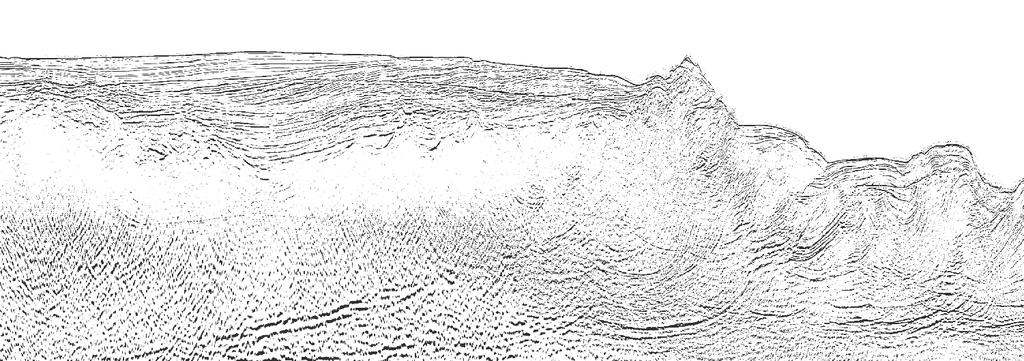
4 FRONTIER RESEARCH ON EARTH EVOLUTION, VOL. Eurasian Plate Na ~ cm/yr Philippine Sea Plate Pacific Plate nk c Izu-Bonin Ar D C gh u A B ai Tro JAPAN D Izu Tokai C Kii (M.) su Ri dg e S Izu-Bonin Arc h roug kai T Nan D D D Ze ni D D D9 D D NT- TKY NT- km NT- KR9 Bathymetry and topography (m) Figure. Bathymetry map and locations of MCS (black thin and dotted) and OBS/MCS (blue thin) lines in the Nankai Trough margin off southwest Japan. Inset is a regional tectonic map showing the location of the study area (red box). The Philippine Sea Plate (PSP) subducts beneath the Eurasian Plate to the northwest with convergence rate ~ cm/yr [Seno et al., 99]. The Nankai subduction zone may be divided into four discrete domains (A through D) marked by distinct megathrust earthquake ruptures [Ando, 9; Sugiyama, 99]. The eastern Nankai subduction zone is composed of two domains (C and D), the Tonankai and Tokai segments, respectively. Contours with purple thin lines show the 9 Tonankai (M =.) coseismic slip amounts (meter) estimated from seismic inversion [Kikuchi et al., ]. The paleo-zenisu ridge distribution that was suggested by magnetic anomaly data (Le Pichon et al., 99) is shown by a polygon with heavy yellow line. Heavy black parts on lines D, S, TKY, and mark the MCS and OBS profiles shown in Figs.,, and. NW SE Two-way Time (sec) Outer ridge Forearc basin S Line D Cover sequence Accretionary prism collem R Oceanic crust 9 - Distance from frontal thrust (km) SW NE Line S Two-way Time (sec) t Oceanic crust Distance (km) Figure. Time-migrated MCS profiles of dip line D and strike line S showing the subducted ridge in the Tonankai segment. Subducting oceanic crust is shaded in light blue. Vertical exaggeration is about : at the seafloor.

")


 G.")


![after Kodaira et al. []).](/docs-images/73/69403894/images/5-11.jpg "Lighter colored regions")


![al. []).](/docs-images/73/69403894/images/5-16.jpg "obtained by prestack")

,")


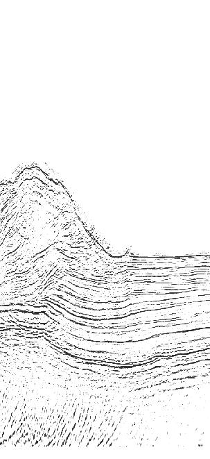

5 FRONTIER RESEARCH ON EARTH EVOLUTION, VOL. Zenisu ridge Inner slope Nankai trough Depth (km) Line TKY Accretionary prism E Old accretionary prism (backstop) F South ridge North ridge Uppermost mantle Velocity (km/s) G Distance (km) Figure. Wide-angle OBS survey-derived crustal velocity structure model showing the subducted ridges in the Tokai segment, which was obtained from a first arrival refraction tomography (modified after Kodaira et al. []). Lighter colored regions shows no seismic ray sampling. Dotted lines indicate reflectors picked from a seismic reflection image (Figure b of Kodaira et al. []). obtained by prestack depth migrations of the OBS wide-angle and conventional MCS seismic data. The black (E), blue (F) and red (G) dotted lines are interpreted as reflectors from the top of an old accretionary complex, the top and the bottom of an igneous crust, respectively. NW SE Forearc basin Two-way Time (sec) Outer ridge Line Cover sequence Nankai Accretionary prism play S 9 Distance from frontal thrust (km) Figure. Time-migrated MCS profile of dip line showing the splay fault in the Tonankai segment. Subducting oceanic crust is shaded in light blue. Location of the splay fault's initial branching is marked by red dotted circle. Red arrows show motions of the splay fault slip. The splay fault branches upward from the plate-boundary interface at ~ km landward from the frontal thrust, approaching the seafloor just seaward of the outer ridge, breaking through the overriding accretionary wedge. Vertical exaggeration is about : at the seafloor.
")

 M.")
 S D km h ug ai Tro k n a N")


![profiles [Nakanishi et al., ].](/docs-images/73/69403894/images/6-10.jpg "Uplifted outer ridge lt y la Sp u fa o r")


 ine ilipp Sea e Plat Ph ust r")


 [Park")
6 FRONTIER RESEARCH ON EARTH EVOLUTION, VOL. LEGEND 9 9 coseismic slip (meter) Seaward end of backstop Splay fault D Subducted ridge Inferred subducted ridge distribution Izu Tokai Earthquake swarm (9) M.9 Earthquake (9) C Kii Izu-Bonin Arc K 9 (M.) S D km h ug ai Tro k n a N Bathymetry and topography (m) Figure. Spatial distribution of the elongate, trough-parallel subducted ridge in the eastern Nankai subduction zone. The subducted ridge is shaded in light black. Heavy red and thin blue parts on the seismic survey lines mark the subducted ridge and the splay fault, respectively. The seaward end of backstop was constrained by several wide-angle OBS profiles [Nakanishi et al., ]. Uplifted outer ridge lt y la Sp u fa o r n? Sea ucted Subrdidge e Plat Ph r ath g Me ine ilipp ust g pl Ridge region Outer ridge Forearc basin Neogene-Quaternary accretionary prism Cretaceous-Tertiary accretionary prism lay Nankai Trough Sp? (Backstop) ine ilipp Sea e Plat Ph ust r ath g Me lt fau Ridge-free region Figure. Schematic cross sections showing the ridge-backstop collision in the Tonankai segment. All of the interseismic elastic strain at the updip portion of the seismogenic zone could be released by the coseismic splay fault slip alone, but it seems more likely that there would be slip partitioning between it and the subduction zone (i.e., plate-boundary interface) [Park et al., ]. The dotted and solid lines at the updip of the Tonankai megathrust indicate the possible slips along the splay fault and subduction zone, respectively. The subducting ridge may be responsible for the steeper slope angle of the splay fault.
Seismicity around the seaward updip limit of the Nankai Trough seismogenic zone revealed by repeated OBS observations
 FRONTIER RESEARCH ON EARTH EVOLUTION, VOL. 1 Seismicity around the seaward updip limit of the Nankai Trough seismogenic zone revealed by repeated OBS observations Koichiro Obana 1, Shuichi Kodaira 1, Yoshiyuki
Slip distributions of the 1944 Tonankai and 1946 Nankai earthquakes including the horizontal movement effect on tsunami generation
 Slip distributions of the 1944 Tonankai and 1946 Nankai earthquakes including the horizontal movement effect on tsunami generation Toshitaka Baba Research Program for Plate Dynamics, Institute for Frontier
Splay fault and megathrust earthquake slip in the Nankai Trough
 Earth Planets Space, 53, 243 248, 2001 Splay fault and megathrust earthquake slip in the Nankai Trough Phil R. Cummins, Takane Hori, and Yoshiyuki Kaneda Frontier Research Program for Subduction Dynamics,
Crustal structure across the coseismic rupture zone of the 1944 Tonankai earthquake, the central Nankai Trough seismogenic zone
 JOURNAL OF GEOPHYSICAL RESEARCH, VOL. 17, NO. B1, 7, 129/1JB424, 2 Crustal structure across the coseismic rupture zone of the 1944 Tonankai earthquake, the central Nankai Trough seismogenic zone Ayako
Seismic activity beneath the Nankai trough revealed by DONET ocean-bottom observations
 Mar Geophys Res (214) 35:271 284 DOI 1.17/s111-13-9195-3 SPECIAL ISSUE PAPER Seismic activity beneath the Nankai trough revealed by DONET ocean-bottom observations Masaru Nakano Takeshi Nakamura Shin-ichiro
Electrical Conductivity Structures around Seismically Locked Regions
 Electrical Conductivity Structures around Seismically Locked Regions Tada-nori Goto Program for Deep Sea Research, IFREE, Japan Agency for Marine-Earth Science and Technology 1. Introduction Existence
REGIONAL CHARACTERISTICS OF STRESS FIELD AND ITS DYNAMICS IN AND AROUND THE NANKAI TROUGH, JAPAN
 46 4 2003 7 CHINESE JOURNAL OF GEOPHYSICS Vol. 46, No. 4 July, 2003 1 1 2 3 1, 100037 2, 920-1192 3, 237-0061,,, : -. (10 22 ), (60 85km) ; (40 ), (160km)..,. GPS,, -,,.,,,.. 0001-5733(2003) 04-0488 -
Japan Agency for Marine-Earth Science and Technology (JAMSTEC), 2-15 Natsushima-cho, Yokosuka JAPAN
, 2-15 Natsushima-cho, Yokosuka JAPAN") Dense Ocean floor Network System for Mega Thrust Earthquakes & Tsunamis(DONET) -Towards Understanding Mega Thrust Earthquakes, the Geohazard & Disaster Mitigation- Yoshiyuki KANEDA, Katsuyoshi KAWAGUCHI,
Dense Ocean floor Network System for Mega Thrust Earthquakes & Tsunamis(DONET) -Towards Understanding Mega Thrust Earthquakes, the Geohazard & Disaster Mitigation- Yoshiyuki KANEDA, Katsuyoshi KAWAGUCHI,
Sendai Earthquake NE Japan March 11, Some explanatory slides Bob Stern, Dave Scholl, others updated March
 Sendai Earthquake NE Japan March 11, 2011 Some explanatory slides Bob Stern, Dave Scholl, others updated March 14 2011 Earth has 11 large plates and many more smaller ones. Plates are 100-200 km thick
Structural factors controlling the rupture process of a megathrust earthquake at the Nankai trough seismogenic zone
 Geophys. J. Int. (2002) 149, 815 835 Structural factors controlling the rupture process of a megathrust earthquake at the Nankai trough seismogenic zone S. Kodaira, 1 E. Kurashimo, 2 J.-O. Park, 1 N. Takahashi,
Urgent aftershock observation of the 2004 off the Kii Peninsula earthquake using ocean bottom seismometers
 LETTER Earth Planets Space, 57, 363 368, 2005 Urgent aftershock observation of the 2004 off the Kii Peninsula earthquake using ocean bottom seismometers Shin ichi Sakai 1, Tomoaki Yamada 1, Masanao Shinohara
Long-term Crustal Deformation in and around Japan, Simulated by a 3-D Plate Subduction Model
 Long-term Crustal Deformation in and around Japan, Simulated by a 3-D Plate Subduction Model Chihiro Hashimoto (1) and Mitsuhiro Matsu ura (2) (1) Institute of Frontier Research for Earth Evolution, Japan
Evidence for a slab fragment wedged under Tokyo and its tectonic and seismic implications
 Supplementary Information to accompany Evidence for a slab fragment wedged under Tokyo and its tectonic and seismic implications Shinji Toda, Ross S. Stein, Stephen H. Kirby, and Serkan B. Bozkurt This
Intraoceanic thrusts in the Nankai Trough off the Kii Peninsula: Implications for intraplate earthquakes
 Click Here for Full Article GEOPHYSICAL RESEARCH LETTERS, VOL. 36, L06303, doi:10.1029/2008gl036974, 2009 Intraoceanic thrusts in the Nankai Trough off the Kii Peninsula: Implications for intraplate earthquakes
Coseismic slip distribution of the 1946 Nankai earthquake and aseismic slips caused by the earthquake
 Earth Planets Space, 53, 235 241, 2001 Coseismic slip distribution of the 1946 Nankai earthquake and aseismic slips caused by the earthquake Yuichiro Tanioka 1 and Kenji Satake 2 1 Meteorological Research
Depth-dependent slip regime on the plate interface revealed from slow earthquake activities in the Nankai subduction zone
 2010/10/11-14 Earthscope Workshop Depth-dependent slip regime on the plate interface revealed from slow earthquake activities in the Nankai subduction zone Kazushige Obara, ERI, Univ. Tokyo Recurrence
We A10 12 Common Reflection Angle Migration Revealing the Complex Deformation Structure beneath Forearc Basin in the Nankai Trough
 We A10 12 Common Reflection Angle Migration Revealing the Complex Deformation Structure beneath Forearc Basin in the Nankai Trough K. Shiraishi* (JAMSTEC), M. Robb (Emerson Paradigm), K. Hosgood (Emerson
GEOPHYSICAL RESEARCH LETTERS, VOL. 37, L09304, doi: /2010gl042935, 2010
 Click Here for Full Article GEOPHYSICAL RESEARCH LETTERS, VOL. 37,, doi:10.1029/2010gl042935, 2010 Seismic characteristics around the fault segment boundary of historical great earthquakes along the Nankai
Inversion Analysis of Historical Interplate Earthquakes Using Seismic Intensity Data
 Inversion Analysis of Historical Interplate Earthquakes Using Seismic Intensity Data Katsuhisa Kanda and Masayuki Takemura Kobori Research Complex, Kajima Corporation, Tokyo 107-8502, Japan Summary An
Velocity-Interface Structure of the Southwestern Ryukyu Subduction Zone from EW OBS/MCS Data
 Marine Geophysical Researches 22: 265-287, 2001. 2002 Kluwer Academic Publishers. Printed in the Netherlands. Velocity-Interface Structure of the Southwestern Ryukyu Subduction Zone from EW9509-1 OBS/MCS
Seismic structure of western end of the Nankai trough seismogenic zone
 JOURNAL OF GEOPHYSICAL RESEARCH, VOL. 107, NO. B10, 2212, doi:10.1029/2000jb000121, 2002 Seismic structure of western end of the Nankai trough seismogenic zone Narumi Takahashi, Shuichi Kodaira, Ayako
The influence of short wavelength variations in viscosity on subduction dynamics
 1 Introduction Deformation within the earth, driven by mantle convection due primarily to cooling and subduction of oceanic lithosphere, is expressed at every length scale in various geophysical observations.
I point out two possible paradoxical difficulties in the important target of the IODP in subduction zones, i.e.,
 Drilling the Seismogenic Zone: Some Paradoxes Tetsuzo Seno Earthquake Research Institute, University of Tokyo (Bull. Earthq. Res. Inst., subumitted on January 16, 2003; accepted on July 22, 2003) Abstract
Multi-channel seismic reflection experiments in Izu-Ogasawara arc cruises-
 JAMSTEC Report of Research and Development, Volume 4, November 2006, 1 12 Multi-channel seismic reflection experiments in Izu-Ogasawara arc -2005 cruises- K. Takizawa 1, T. Tsuru 2, Y. Kaiho 1, M. Yamashita
LETTER Earth Planets Space, 57, , 2005
 LETTER Earth Planets Space, 57, 1115 1120, 2005 A tectonic interpretation of NW-SE strike-slip faulting during the 2004 off the Kii peninsula earthquakes, Japan: Probable tear of the Philippine Sea plate
Dense Ocean floor Network System for Earthquakes and Tsunamis DONET
 Dense Ocean floor Network System for Earthquakes and Tsunamis DONET Yoshiyuki Kaneda Japan Agency for Marine-Earth Science and Technology (JAMSTEC) ION 1 Earthquakes in the Nankai Trough Tokai Nankai Hyuga
Earth Science, (Tarbuck/Lutgens) Chapter 10: Mountain Building
 Chapter 10: Mountain Building") Earth Science, (Tarbuck/Lutgens) Chapter 10: Mountain Building 1) A(n) fault has little or no vertical movements of the two blocks. A) stick slip B) oblique slip C) strike slip D) dip slip 2) In a(n) fault,
Earth Science, (Tarbuck/Lutgens) Chapter 10: Mountain Building 1) A(n) fault has little or no vertical movements of the two blocks. A) stick slip B) oblique slip C) strike slip D) dip slip 2) In a(n) fault,
Continental Margin Geology of Korea : Review and constraints on the opening of the East Sea (Japan Sea)
") Continental Margin Geology of Korea : Review and constraints on the opening of the East Sea (Japan Sea) Han-Joon Kim Marine Satellite & Observation Tech. Korea Ocean Research and Development Institute
Continental Margin Geology of Korea : Review and constraints on the opening of the East Sea (Japan Sea) Han-Joon Kim Marine Satellite & Observation Tech. Korea Ocean Research and Development Institute
overlie the seismogenic zone offshore Costa Rica, making the margin particularly well suited for combined land and ocean geophysical studies (Figure
 Chapter 1 Introduction Historically, highly destructive large magnitude (M w >7.0) underthrusting earthquakes nucleate along the shallow segment of subduction zone megathrust fault, and this region of
MAR110 Lecture #5 Plate Tectonics-Earthquakes
 1 MAR110 Lecture #5 Plate Tectonics-Earthquakes Figure 5.0 Plate Formation & Subduction Destruction The formation of the ocean crust from magma that is upwelled into a pair of spreading centers. Pairs
USU 1360 TECTONICS / PROCESSES
 USU 1360 TECTONICS / PROCESSES Observe the world map and each enlargement Pacific Northwest Tibet South America Japan 03.00.a1 South Atlantic Arabian Peninsula Observe features near the Pacific Northwest
Present-day deformation across the southwest Japan arc: Oblique subduction of the Philippine Sea plate and lateral slip of the Nankai forearc
 LETTER Earth Planets Space, 55, 643 647, 2003 Present-day deformation across the southwest Japan arc: Oblique subduction of the Philippine Sea plate and lateral slip of the Nankai forearc Takao Tabei 1,
9th Workshop on Three-Dimensional Modelling of Seismic Waves Generation, Propagation and their Inversion
 1965-36 9th Workshop on Three-Dimensional Modelling of Seismic Waves Generation, Propagation and their Inversion 22 September - 4 October, 2008 Tomography and Active Tectonics in Kanto, Japan Francis T.
Plate Tectonics. Structure of the Earth
 Plate Tectonics Structure of the Earth The Earth can be considered as being made up of a series of concentric spheres, each made up of materials that differ in terms of composition and mechanical properties.
Evolution of Continents Chapter 20
 Evolution of Continents Chapter 20 Does not contain complete lecture notes. Mountain belts Orogenesis the processes that collectively produce a mountain belt Includes folding, thrust faulting, metamorphism,
A) B) C) D) 4. Which diagram below best represents the pattern of magnetic orientation in the seafloor on the west (left) side of the ocean ridge?
 B) C) D) 4. Which diagram below best represents the pattern of magnetic orientation in the seafloor on the west (left) side of the ocean ridge?") 1. Crustal formation, which may cause the widening of an ocean, is most likely occurring at the boundary between the A) African Plate and the Eurasian Plate B) Pacific Plate and the Philippine Plate C)
1. Crustal formation, which may cause the widening of an ocean, is most likely occurring at the boundary between the A) African Plate and the Eurasian Plate B) Pacific Plate and the Philippine Plate C)
GSA DATA REPOSITORY
 1 GSA DATA REPOSITORY 2010282 Bangs et al. Supplemental Material Bottom Water Currents and Seafloor Erosion as a Triggering Mechanism The nearest bottom current measurements were made ~ 60 km to the east
JAMSTEC Marine Geophysical Projects for Researches on Subduction Cycles and Deformation
 JAMSTEC Marine Geophysical Projects for Researches on Subduction Cycles and Deformation Shuichi Kodaira Research Center for Earthquake and Tsunami JAMSTEC JAMSTEC Marine Geophysical Projects Motivation:
FOOT OF THE CONTINENTAL SLOPE IN ARTICLE 76
 FOOT OF THE CONTINENTAL SLOPE IN ARTICLE 76 Vaughan Stagpoole, Institute of Geological & Nuclear Sciences, Lower Hutt, New Zealand, v.stagpoole@gns.cri.nz Ray Wood, Institute of Geological & Nuclear Sciences,
Laboratory #7: Plate Tectonics
 Materials Needed: 1. Pencil 2. Colored Pencils 3. Metric/Standard Ruler 4. Calculator 5. Tracing Paper Laboratory #7: Plate Tectonics Plate Tectonics The Earth is composed of layers. At the center is a
Global Tectonics. Kearey, Philip. Table of Contents ISBN-13: Historical perspective. 2. The interior of the Earth.
 Global Tectonics Kearey, Philip ISBN-13: 9781405107778 Table of Contents Preface. Acknowledgments. 1. Historical perspective. 1.1 Continental drift. 1.2 Sea floor spreading and the birth of plate tectonics.
10. Paleomagnetism and Polar Wandering Curves.
 Map of ocean floor Evidence in Support of the Theory of Plate Tectonics 10. Paleomagnetism and Polar Wandering Curves. The Earth's magnetic field behaves as if there were a bar magnet in the center of
Crustal structure and deformation at the northern Manila Trench between Taiwan and Luzon islands
 Available online at www.sciencedirect.com Tectonophysics 466 (2009) 229 240 www.elsevier.com/locate/tecto Crustal structure and deformation at the northern Manila Trench between Taiwan and Luzon islands
Microseismicity at the seaward updip limit of the western Nankai Trough seismogenic zone
 JOURNAL OF GEOPHYSICAL RESEARCH, VOL. 108, NO. B10, 2459, doi:10.1029/2002jb002370, 2003 Microseismicity at the seaward updip limit of the western Nankai Trough seismogenic zone Koichiro Obana, Shuichi
Resistivity image of the Philippine Sea Plate around the 1944 Tonankai earthquake zone deduced by Marine and Land MT surveys
 LETTER Earth Planets Space, 57, 29 213, 25 Resistivity image of the Philippine Sea Plate around the 1944 Tonankai earthquake zone deduced by Marine and Land MT surveys Takafumi Kasaya 1, Tada-nori Goto
Dynamic Crust Practice
 1. Base your answer to the following question on the cross section below and on your knowledge of Earth science. The cross section represents the distance and age of ocean-floor bedrock found on both sides
Chapter 2. Earthquake and Damage
 EDM Report on the Chi-Chi, Taiwan Earthquake of September 21, 1999 2.1 Earthquake Fault 2.1.1 Tectonic Background The island of Taiwan is located in the complex junction where the Eurasian and Philippine
The Japanese University Joint Seismic Observations at the Niigaka-Kobe Tectonic Zone
 Bull. Earthq. Res. Inst. Univ. Tokyo Vol. 2*,**/ pp. +-- +.1 * The Japanese University Joint Seismic Observations at the Niigaka-Kobe Tectonic Zone The Japanese University Group of the Joint Seismic Observations
Lab 1: Plate Tectonics April 2, 2009
 Name: Lab 1: Plate Tectonics April 2, 2009 Objective: Students will be introduced to the theory of plate tectonics and different styles of plate margins and interactions. Introduction The planet can be
Plate Tectonics. entirely rock both and rock
 Plate Tectonics I. Tectonics A. Tectonic Forces are forces generated from within Earth causing rock to become. B. 1. The study of the origin and arrangement of Earth surface including mountain belts, continents,
NAME HOMEWORK ASSIGNMENT #4 MATERIAL COVERS CHAPTERS 19, 20, 21, & 2
 NAME HOMEWORK ASSIGNMENT #4 MATERIAL COVERS CHAPTERS 19, 20, 21, & 2 Assignment is due the beginning of the class period on December 14, 2004. Mark answers on a scantron sheet, which will be provided.
2 The Geology and Tectonics of the Tohoku Region
 2 The Geology and Tectonics of the Tohoku Region Japan is part of the "Ring of Fire," the belt of earthquakes and volcanic activity that distinguishes the active margins of the Pacific Ocean from the passive
D DAVID PUBLISHING. Deformation of Mild Steel Plate with Linear Cracks due to Horizontal Compression. 1. Introduction
 Journal of Control Science and Engineering 1 (2015) 40-47 doi: 10.17265/2328-2231/2015.01.005 D DAVID PUBLISHING Deformation of Mild Steel Plate with Linear Cracks due to Horizontal Compression Mitsuru
Gas Hydrate BSR and Possible Fluid Migration in the Nankai Accretionary Prism off Muroto
 Gas Hydrate BSR and Possible Fluid Migration in the Nankai Accretionary Prism off Muroto Sumito Morita 1), Yasuyuki Nakamura 2), Shin ichi Kuramoto 3), Nathan Bangs 4) and Asahiko Taira 3) 1) Geological
Amplification of Tsunami Heights by Delayed Rupture of Great Earthquakes along the Nankai Trough
 Amplification of Tsunami Heights by Delayed Rupture of Great Earthquakes along the Nankai Trough Kentaro Imai 1,2, Kenji Satake 2 and Takashi Furumura 1,2 1 Center for Integrated Disaster Information Research,
On May 4, 2001, central Arkansas experienced an M=4.4 earthquake followed by a
 1. Introduction On May 4, 2001, central Arkansas experienced an M=4.4 earthquake followed by a surprisingly large number of small earthquakes. We recorded about 2500 above the ambient noise level on a
Deep Seismic Profiling in the Tokyo Metropolitan Area for Strong Ground Motion Prediction
 Deep Seismic Profiling in the Tokyo Metropolitan Area for Strong Ground Motion Prediction Hiroshi Sato 1, Naoshi Hirata 1, Takaya Iwasaki 1, Kazuki Koketsu 1, Tanio Ito 2, Keiji Kasahara 3, Kiyoshi Ito
Earth and Planetary Science Letters
 Earth and Planetary Science Letters 362 (2013) 99 107 Contents lists available at SciVerse ScienceDirect Earth and Planetary Science Letters journal homepage: www.elsevier.com/locate/epsl A mega-splay
11.1 Rock Deformation
 Tarbuck Lutgens Mountain Building 11.1 Rock Deformation Factors Affecting Deformation Factors that influence the strength of a rock and how it will deform include temperature, confining pressure, rock
Subduction zones are complex plate boundaries in which variable geometry and structure can be
 1 Chapter 1 Introduction Subduction zones are complex plate boundaries in which variable geometry and structure can be seismically observed. The along-strike transition from flat to normal subduction is
Parts of the Sevier/ Laramide Orogeny
 Parts of the Sevier/ Laramide Orogeny AA. Accretionary Prism BB. Forearc Basin Sediment scraped off of subducting plate Sediment derived from the volcanic arc CC. Volcanic Arc Magmatic intrusion into the
ANOTHER MEXICAN EARTHQUAKE! Magnitude 7.1, Tuesday Sept. 19, 2017
 ANOTHER MEXICAN EARTHQUAKE! Magnitude 7.1, Tuesday Sept. 19, 2017 Why is there no oceanic crust older than 200 million years? SUBDUCTION If new oceanic crust is being continuously created along the earth
R/V Kairei Cruise Report KR Seismic study in the northwestern Pacific region. Jan. 4, 2011 Jan. 20, 2011
 R/V Kairei Cruise Report KR11-01 Seismic study in the northwestern Pacific region Jan. 4, 2011 Jan. 20, 2011 Japan Agency for Marine-Earth Science and Technology (JAMSTEC) Contents: 1.Cruise Information:
The Sea Floor. Chapter 2
 The Sea Floor Chapter 2 Geography of the Ocean Basins World ocean is the predominant feature on the Earth in total area Northern Hemisphere = 61% of the total area is ocean. Southern Hemisphere = about
Disaster Prevention Research Section, Technology Center, Taisei Corporation, Yokohama, Japan 2
 LONG-PERIOD GROUND MOTION SIMULATION OF 2004 OFF THE KII PENINSULA EARTHQUAKES AND PREDICTION OF FUTURE M8 CLASS EARTHQUAKES ALONG NANKAI TROUGH SUBDUCTION ZONE, SOUTH OF JAPAN ISLAND Chiaki Yoshimura
Differentiating earthquake tsunamis from other sources; how do we tell the difference?
 Differentiating earthquake tsunamis from other sources; how do we tell the difference? David Tappin (1), Stephan Grilli (2), Jeffrey Harris (2), Timothy Masterlark (3), James Kirby (4), Fengyan Shi Shi
North America subducted under Rubia. Are there modern analogs for Hildebrand s model of North America subducting under Rubia?
 North America subducted under Rubia Are there modern analogs for Hildebrand s model of North America subducting under Rubia? In the Geological Society of America Special Papers Did Westward Subduction
MECHANISM OF THE 2011 TOHOKU-OKI EARTHQUAKE: INSIGHT FROM SEISMIC TOMOGRAPHY
 Proceedings of the International Symposium on Engineering Lessons Learned from the 2011 Great East Japan Earthquake, March 1-4, 2012, Tokyo, Japan MECHANISM OF THE 2011 TOHOKU-OKI EARTHQUAKE: INSIGHT FROM
Application of common reflection angle migration for imaging deformation structures in an inner accretionary wedge, Nankai Trough, Japan
 Geophysical Prospecting, 2018 doi: 10.1111/1365-2478.12724 Application of common reflection angle migration for imaging deformation structures in an inner accretionary wedge, Nankai Trough, Japan Kazuya
Copyright McGraw-Hill Education. All rights reserved. No reproduction or distribution without the prior written consent of McGraw-Hill Education
 Copyright McGraw-Hill Education. All rights reserved. No reproduction or distribution without the prior written consent of McGraw-Hill Education Tibetan Plateau and Himalaya -southern Asia 11.00.a VE 10X
FORCES ON EARTH UNIT 3.2. An investigation into how Newton s Laws of Motion are applied to the tectonic activity on Earth.
 FORCES ON EARTH UNIT 3.2 An investigation into how Newton s Laws of Motion are applied to the tectonic activity on Earth. USE THESE NOTES: OUR HOME PLANET EARTH: What do you know about our planet? SO.HOW
Interaction between two subducting plates under Tokyo and its possible effects on seismic hazards
 Click Here for Full Article GEOPHYSICAL RESEARCH LETTERS, VOL. 34,, doi:10.1029/2007gl030763, 2007 Interaction between two subducting plates under Tokyo and its possible effects on seismic hazards Francis
Masataka; Matsuoka, Toshifumi. Citation EARTH PLANETS AND SPACE (2011), 63(
, 63(") Title Potential tsunamigenic faults of th of Tohoku Earthquake Tsuji, Takeshi; Ito, Yoshihiro; Kid Author(s) Yukihito; Fujimoto, Hiromi; Ashi, J Masataka; Matsuoka, Toshifumi Citation EARTH PLANETS AND
Title Potential tsunamigenic faults of th of Tohoku Earthquake Tsuji, Takeshi; Ito, Yoshihiro; Kid Author(s) Yukihito; Fujimoto, Hiromi; Ashi, J Masataka; Matsuoka, Toshifumi Citation EARTH PLANETS AND
Topic 5: The Dynamic Crust (workbook p ) Evidence that Earth s crust has shifted and changed in both the past and the present is shown by:
 Evidence that Earth s crust has shifted and changed in both the past and the present is shown by:") Topic 5: The Dynamic Crust (workbook p. 65-85) Evidence that Earth s crust has shifted and changed in both the past and the present is shown by: --sedimentary horizontal rock layers (strata) are found
Topic 5: The Dynamic Crust (workbook p. 65-85) Evidence that Earth s crust has shifted and changed in both the past and the present is shown by: --sedimentary horizontal rock layers (strata) are found
Oceanography, An Invitation to Marine Science 9e Tom Garrison. Ocean Basins Cengage Learning. All Rights Reserved.
 Oceanography, An Invitation to Marine Science 9e Tom Garrison 4 Ocean Basins Key Concepts Tectonic forces shape the seabed The ocean floor is divided into continental margins and deep ocean basins The
Chapter 10: Deformation and Mountain Building. Fig. 10.1
 Chapter 10: Deformation and Mountain Building Fig. 10.1 OBJECTIVES Describe the processes of rock deformation and compare and contrast ductile and brittle behavior in rocks. Explain how strike and dip
Chapter 7 Plate Tectonics
 Chapter 7 Plate Tectonics Earthquakes Earthquake = vibration of the Earth produced by the rapid release of energy. Seismic Waves Focus = the place within the Earth where the rock breaks, producing an earthquake.
Definition: Plate tectonics: the theory that the earth s surface consists of a mosaic of internally rigid plates that move relative to each other
 Chapter 2 Plate tectonics Definition: Plate tectonics: the theory that the earth s surface consists of a mosaic of internally rigid plates that move relative to each other Plate boundaries: zones of faulting
SOURCE MODELING OF SUBDUCTION-ZONE EARTHQUAKES AND LONG-PERIOD GROUND MOTION VALIDATION IN THE TOKYO METROPOLITAN AREA
 SOURCE MODELING OF SUBDUCTION-ZONE EARTHQUAKES AND LONG-PERIOD GROUND MOTION VALIDATION IN THE TOKYO METROPOLITAN AREA ABSTRACT : Hiroe Miyake 1, Kazuki Koketsu 2, and Takashi Furumura 3,2 1 Assistant
The 2011 off the Pacific coast of Tohoku Earthquake related to a strong velocity gradient with the Pacific plate
 LETTER Earth Planets Space, 63, 663 667, 2011 The 2011 off the Pacific coast of Tohoku Earthquake related to a strong velocity gradient with the Pacific plate Makoto Matsubara 1 and Kazushige Obara 2 1
Crustal structure of the southernmost Ryukyu subduction zone: OBS, MCS and gravity modelling
 Geophys. J. Int. (2004) 157, 147 163 Crustal structure of the southernmost Ryukyu subduction zone: OBS, MCS and gravity modelling Tan K. Wang, 1 Shen-Feng Lin, 1 Char-Shine Liu 2 and Cheng-Sung Wang 1,3
An Examination of Accretionary Prisms at the Nobeoka Thrust
 Evan Tam, University of Connecticut UTRIP 2012 Participant, Kimura Labs An Examination of Accretionary Prisms at the Nobeoka Thrust Introduction Accretionary prisms form at convergent plate boundaries,
Geodynamics. Climatic, geomorphic and geodynamic processes Lecture Orogenic wedges. Lecturer: David Whipp
 Geodynamics Climatic, geomorphic and geodynamic processes Lecture 13.3 - Orogenic wedges Lecturer: David Whipp david.whipp@helsinki.fi Geodynamics www.helsinki.fi/yliopisto 1 Goals of this lecture Introduce
Deformation history recorded in accreted sediments in an evolved portion of the Nankai accretionary prism
 Deformation history recorded in accreted sediments in an evolved portion of the Nankai accretionary prism Kohtaro Ujiie Research Program for Plate Dynamics, Institute for Frontier Research on Earth Evolution
Integrated interpretation of Gravity & Magnetic data for delineation of sedimentary thickness in deepwater block of Andman Basin
 P-204 Integrated interpretation of Gravity & Magnetic data for delineation of sedimentary thickness in deepwater block of D. Saha*, C.S. Bahuguna, Kh. Nabakumar, G.Singh, Sudhir Kumar, and Kunal Niyogi,
Marine Science and Oceanography
 Marine Science and Oceanography Marine geology- study of the ocean floor Physical oceanography- study of waves, currents, and tides Marine biology study of nature and distribution of marine organisms Chemical
Tectonic Movements in the Central Kyushu, Japan
 /-,**.. +0 - +0,, +0, +* Tectonic Movements in the Central Kyushu, Japan Keiji TAKEMURA Beppu Geothermal Res. Lab., Kyoto University Abstract The central part of Kyushu, Japan is a locus of active arc-volcanism
Late 20 th Century Tests of the Continental Drift Hypothesis
 Late 20 th Century Tests of the Continental Drift Hypothesis 5 Characteristics of the Ocean Trenches Unless otherwise noted the artwork and photographs in this slide show are original and by Burt Carter.
Learning Objectives (LO)! Lecture 11: Plate Tectonics II! No Homework!! ** Chapter 3 **! What we ll learn today:!
! Lecture 11: Plate Tectonics II! No Homework!! ** Chapter 3 **! What we ll learn today:!") Learning Objectives (LO)! Lecture 11: Plate Tectonics II! No Homework!! ** Chapter 3 **! What we ll learn today:! 1. List the three types of tectonic plate boundaries! 2. Describe the processes occurring
Learning Objectives (LO)! Lecture 11: Plate Tectonics II! No Homework!! ** Chapter 3 **! What we ll learn today:! 1. List the three types of tectonic plate boundaries! 2. Describe the processes occurring
Crustal deformation by the Southeast-off Kii Peninsula Earthquake
 Crustal deformation by the Southeast-off Kii Peninsula Earthquake 51 Crustal deformation by the Southeast-off Kii Peninsula Earthquake Tetsuro IMAKIIRE, Shinzaburo OZAWA, Hiroshi YARAI, Takuya NISHIMURA
Ocean Basins, Bathymetry and Sea Levels
 Ocean Basins, Bathymetry and Sea Levels Chapter 4 Please read chapter 5: sediments for next class and start chapter 6 on seawater for Thursday Basic concepts in Chapter 4 Bathymetry the measurement of
Ling Bai 1, Ichiro Kawasaki 1, Tianzhong Zhang 2, and Yuzo Ishikawa 3. Earth Planets Space, 58, , 2006
 Earth Planets Space, 58, 823 830, 2006 An improved double-difference earthquake location algorithm using sp phases: application to the foreshock and aftershock sequences of the 2004 earthquake offshore
Essentials of Geology, 11e
 Essentials of Geology, 11e Crustal Deformation and Mountain Building Chapter 17 Instructor Jennifer Barson Spokane Falls Community College Geology 101 Stanley Hatfield Southwestern Illinois College Jennifer
Aftershocks of the December 7, 2012 intraplate doublet near the Japan Trench axis
 Obana et al. Earth, Planets and Space 20, 66:24 FULL PAPER OpenAccess Aftershocks of the December 7, 20 intraplate doublet near the Japan Trench axis Koichiro Obana 1,2*, Shuichi Kodaira 1,2, Yasuyuki
Source Characteristics of Large Outer Rise Earthquakes in the Pacific Plate
 Source Characteristics of Large Outer Rise Earthquakes in the Pacific Plate T. Sasatani, N. Takai, M. Shigefuji, and Y. Miyahara Hokkaido University, Sapporo, Japan W. Kawabata Electric Power Development
MAR110 LECTURE #6 West Coast Earthquakes & Hot Spots
 17 September 2007 Lecture 6 West Coast Earthquakes & Hot Spots 1 MAR110 LECTURE #6 West Coast Earthquakes & Hot Spots Figure 6.1 Plate Formation & Subduction Destruction The formation of the ocean crust
Real time Monitoring System for Earthquakes and Tsunamis (DONET)
") Real time Monitoring System for Earthquakes and Tsunamis (DONET) NankaiTrough Yoshiyuki Kaneda Japan Agency for Marine-Earth Science and Technology (JAMSTEC) POGO@Seoul Presentation 1 Earthquakes in the
Real time Monitoring System for Earthquakes and Tsunamis (DONET) NankaiTrough Yoshiyuki Kaneda Japan Agency for Marine-Earth Science and Technology (JAMSTEC) POGO@Seoul Presentation 1 Earthquakes in the
Depth (Km) + u ( ξ,t) u = v pl. η= Pa s. Distance from Nankai Trough (Km) u(ξ,τ) dξdτ. w(x,t) = G L (x,t τ;ξ,0) t + u(ξ,t) u(ξ,t) = v pl
 + u ( ξ,t) u = v pl. η= Pa s. Distance from Nankai Trough (Km) u(ξ,τ) dξdτ. w(x,t) = G L (x,t τ;ξ,0) t + u(ξ,t) u(ξ,t) = v pl") Slip history during one earthquake cycle at the Nankai subduction zone, inferred from the inversion analysis of levelling data with a viscoelastic slip response function Mitsuhiro Matsu'ura, Akira Nishitani
Slip history during one earthquake cycle at the Nankai subduction zone, inferred from the inversion analysis of levelling data with a viscoelastic slip response function Mitsuhiro Matsu'ura, Akira Nishitani
SUPPLEMENTARY INFORMATION
 SUPPLEMENTARY INFORMATION doi: 10.1038/ngeo739 Supplementary Information to variability and distributed deformation in the Marmara Sea fault system Tobias Hergert 1 and Oliver Heidbach 1,* 1 Geophysical
caribbean basins, tectonics and hydrocarbons university of texas institute for geophysics
 Copyright by Trevor John Aitken 2005 CENOZOIC STRATIGRAPHIC AND TECTONIC HISTORY OF THE GRENADA AND TOBAGO BASINS AS DETERMINED FROM MARINE SEISMIC DATA, WELLS, AND ONLAND GEOLOGY by Trevor John Aitken,