Page 1 of 9. GSA Data Repository item #
|
|
|
- Chester Lee
- 6 years ago
- Views:
Transcription
1 GSA Data Repository item #146 Ingersoll, R.V., et al., 14, Paleotectonics of a complex Miocene half graben formed above a detachment fault: The Diligencia basin, Orocopia Mountains, southern California: Lithopshere, doi:10.11/l3.1. PREVIOUS WORK The nearly simultaneous publication of evidence for large lateral displacement along faults of the San Andreas system by Crowell (52), and Hill and Dibblee (53) initiated a decades-long search for constraints on timing and magnitude of past fault displacements. Subsequent studies included matching similar terranes across faults (e.g., Crowell,, 62, 75a; Matthews, 76; Tennyson, 89; Frizzell and Weigand, 93; Matti and Morton, 93; Powell, 93), matching source terranes to sedimentary deposits across faults (e.g., Bohannon, 75, 76; Ehlig et al., 75; Ehlert, 82, 03; Dillon and Ehlig, 93; Matti and Morton, 93; Sadler, 93; Sadler et al., 93; Weldon et al., 93; Crowell, 03), reconstruction of faunal provinces and paleogeography across faults (e.g., Hall,, 02; Stanley, 87; Graham et al., 89), reconstruction of volcanic centers across faults (e.g., Matthews, 76; Cole and Basu, 92, 95; Frizzell and Weigand, 93; Dickinson, 97), constraining vertical-axis rotations across faults (e.g., Terres and Luyendyk, 85; Hornafius et al., 86; Carter et al., 87; Luyendyk and Hornafius, 87; Luyendyk, 91; Dickinson, 96) and constraining regional reconstructions through plate-tectonic marine records (e.g., Atwater,, 89; Legg, 91; Legg et al., 91; Lonsdale, 91; Nicholson et al., 94; Bohannon and Parsons, 95; Atwater and Stock, 98; Bohannon and Geist, 98). Integration of these diverse data sets into well constrained paleogeographic and paleotectonic reconstructions has steadily advanced during the last years (e.g., Hamilton, 61; Yeats, 68a, 68b; Crowell, 81, 82, 87; Weldon and Humphreys, 86; Tennyson, 89; Sedlock and Hamilton, 91; Wright, 91; Powell and Weldon, 92; Crouch and Suppe, 93; Richard, 93; Nicholson et al., 94; Bohannon and Parsons, 95; Ingersoll and Rumelhart, 99; Ingersoll, 08a). Miller (44) produced the first map of the northern part of the Orocopia Mountains and named the Orocopia Schist, which he presumed to be Precambrian; he commented that the Orocopia Schist resembled the Pelona Schist of Hershey (02). Hill and Dibblee (53) speculated that the northeast end of the Pelona Schist of Sierra Pelona might be offset by the San Andreas fault from the west end of the Orocopia Schist in the Orocopia Mountains (Figs. 1 and 2). Dibblee (54) suggested the presence of Eocene strata somewhere in the Orocopia Mountains, based on the occurrence of Eocene fossils in clasts of the Pliocene Mecca Formation. Williams (56) and Gillies (58) produced the first geologic maps, cross sections and stratigraphic sections of the Diligencia basin area, utilizing informal stratigraphic nomenclature. Kirkpatrick (58) studied the Eocene paleontology, which Crowell and Susuki (59) incorporated into their definition of the Eocene Maniobra Formation. Crowell (, 62, 75a) and Ehlig (68, 81) suggested specific correlations between the Orocopia and Soledad areas across the San Andreas fault, and the Tejon (Plush Ranch) area across the San Gabriel fault. Johnston (61) provided additional micropaleontologic support for the Eocene age of the Maniobra Formation. Crowell and Walker (62) described the anorthosite and related rocks in the Orocopia Mountains and suggested strong similarities with rocks in the San Gabriel Mountains. Woodburne and Whistler (73) described an Early Miocene oreodont from the middle of the Diligencia Formation. Spittler and Arthur (73) suggested that contrasts between the Orocopia and Soledad areas did not support direct correlations across the San Andreas fault. Arthur (74) and Spittler (74) (summarized by Spittler and Arthur, 82) provided new data on volcanic petrology and geochemistry, sedimentology and stratigraphy of the Miocene strata. Howell (74, 75) discussed the paleogeographic and paleotectonic significance of the Maniobra Formation. Bohannon (75, 76) suggested correlations of mid-tertiary nonmarine Page 1 of 9
2 strata across strands of the San Andreas fault, including the Miocene Diligencia Formation (Crowell, 75b) of the Orocopia Mountains; Tennyson (89) modified Bohannon's (75, 76) paleogeographic reconstruction of these basins. Haxel and Dillon (78) described and interpreted the Orocopia Schist and the Chocolate Mountain "thrust" system. Powell (81, 93) and Powell and Weldon (92) described the crystalline rocks of the Orocopia Mountains and proposed possible palinspastic reconstructions. Spittler and Arthur (82) and Squires and Advocate (82) provided new sedimentologic, stratigraphic, petrologic and structural data and interpretations for the Diligencia basin. Terres (84) and Carter et al. (87) determined the extent of clockwise vertical-axis rotations of the Diligencia basin and surrounding areas. Jacobson et al. (88, 96, 00, 02, 07, 11), Jacobson and Dawson (95), and Grove et al. (03) summarized the depositional, metamorphic, structural and tectonic evolution of the Orocopia and related schists. Advocate et al. (88) interpreted the Maniobra Formation as a fault-controlled submarine-canyon deposit, which Grove (93) correlated with submarine-fan deposits of Salinia (across the San Andreas fault). Crowell (93) summarized the structure, stratigraphy, sedimentology and age of the Diligencia Formation, and noted that dextral NW-SE faults and sinistral NE-SW faults that cut the Diligencia Formation resulted from north-south compression that was younger than Middle Miocene and older than Quaternary. Frizzell and Weigand (93) provided new radiometric ages for the Diligencia Formation. Dillon and Ehlig (93), Matti and Morton (93), Powell (93) and Richard (93) included the Orocopia Mountains in their palinspastic reconstructions of southeastern California. Robinson and Frost (96) suggested that faults along the northeast side of the Orocopia Schist antiform represent normal detachment faults, with down-to-the-northeast movement, which resulted in half-graben development of the Diligencia basin. Law et al. (01) summarized the stratigraphy, sedimentology, petrology, structure and tectonic setting of the Diligencia basin area, and discussed a model for half-graben sedimentation (e.g., Leeder and Gawthorpe, 87; Gawthorpe and Leeder, 00) resulting from a theoretical fault bounding the north side of the basin. Vucic (02) and Ebert (04) provided additional thermochronologic, geochronologic and structural analyses for the Orocopia Mountains in order to test models for origin and evolution of the Orocopia Schist, detachment faults and the Diligencia basin. Yin (02) proposed a passive-roof-thrust model for the emplacement of the Pelona-Orocopia Schist. Preliminary results from the present investigation were presented by Ingersoll (09, 10), and Caracciolo et al. () discussed the diagenetic history of the Maniobra and Diligencia formations. REFERENCES CITED Advocate, D.M., Link, M.H., and Squires, R.L., 88, Anatomy and history of an Eocene submarine canyon: the Maniobra Formation, southern California, in Filewicz, M.V., and Squires, R.L., eds., Paleogene stratigraphy, west coast of North America [Book 58]: Pacific Section, Society of Economic Paleontologists and Mineralogists, Los Angeles, p. 58. Arthur, M.A., 74, Stratigraphy and sedimentation of Lower Miocene nonmarine strata of the Orocopia Mountains: constraints for late Tertiary slip on the San Andreas fault system in southern California [M.S. thesis]: University of California, Riverside, 0 p. Atwater, T.,, Implications of plate tectonics for the Cenozoic tectonic evolution of western North America: Geological Society of America Bulletin, v. 81, p , doi:10.11/00-76()81[35:ioptft]2.0.co;2. Page 2 of 9
3 Atwater, T., 89, Plate tectonic history of the northeast Pacific and western North America, in Winterer, E.L., Hussong, D.M., and Decker, R.W., eds., The eastern Pacific Ocean and Hawaii: Boulder, Colorado, Geological Society of America, Geology of North America, v. N, p. 72. Atwater, T., and Stock, J., 98, Pacific-North America plate tectonics of the Neogene southwestern United States: an update: International Geology Review, v., p , doi: / Bohannon, R.G., 75, Mid-Tertiary conglomerates and their bearing on Transverse Range tectonics, southern California, in Crowell, J.C., ed., The San Andreas fault in southern California, a guide to the San Andreas fault from Mexico to the Carrizo Plain: California Division of Mines and Geology Special Report 1, p Bohannon, R.G., 76, Mid-Tertiary nonmarine rocks along the San Andreas fault in southern California [Ph.D. thesis]: University of California, Santa Barbara, 1 p. Bohannon, R.G., and Geist, E., 98, Upper crustal structure and Neogene tectonic development of the California continental borderland: Geological Society of America Bulletin, v. 110, p , doi:10.11/00-76(98)110<0779:ucsant>2.3.co;2. Bohannon, R.G., and Parsons, T., 95, Tectonic implications of post- Ma Pacific and North American relative plate motions: Geological Society of America Bulletin, v. 107, p , doi:10.11/00-76(95)107<0937:tiopmp>2.3.co;2. Caracciolo, L., Arribus, J., Ingersoll, R.V., and Critelli, S.,, The diagenetic destruction of porosity in plutoniclastic petrofacies: the Miocene Diligencia and Eocene Maniobra formations, Orocopia Mountains, southern California, USA: Geological Society of London Special Publication 386, doi: /sp386.9 (first published on July ). Carter, J.N., Luyendyk, B.P., and Terres, R.R., 87, Neogene clockwise tectonic rotation of the eastern Transverse Ranges, California, suggested by paleomagnetic vectors: Geological Society of America Bulletin, v. 98, p. 9 6, doi:10.11/00-76(87)98<9:nctrot>2.0.co;2. Cole, R.B., and Basu, A.R., 92, Middle Tertiary volcanism during ridge-trench interactions in western California: Science, v. 8, p , doi:10.11/science Cole, R.B., and Basu, A.R., 95, Nd-Sr isotopic geochemistry and tectonics of ridge subduction and middle Cenozoic volcanism in western California: Geological Society of America Bulletin, v. 107, p. 7 9, doi:10.11/00-76(95)107<07:nsigat>2.3.co;2. Crouch, J.K., and Suppe, J., 93, Late Cenozoic tectonic evolution of the Los Angeles basin and inner California borderland: a model for core complex-like crustal extension: Geological Society of America Bulletin, v. 105, p , doi:10.11/00-76(93)105<14:lcteot>2.3.co;2. Crowell, J.C., 52, Probable large lateral displacement on San Gabriel fault, southern California: Bulletin of the American Association of Petroleum Geologists, v., p. 35. Crowell, J.C.,, The San Andreas fault in southern California: International Geological Congress Report of the Twenty-First Session Norden, Part, p. 52. Crowell, J.C., 62, Displacement along the San Andreas fault, California: Geological Society of America Special Paper 71, 61 p. Crowell, J.C., 75a, The San Andreas fault in southern California: California Division of Mines and Geology Special Report 1, p. 7. Page 3 of 9
4 Crowell, J.C., 75b, Geologic sketch of the Orocopia Mountains, southeastern California: California Division of Mines and Geology Special Report 1, p Crowell, J.C., 81, An outline of the tectonic history of southeastern California, in Ernst, W.G., ed., The geotectonic development of California [Rubey Volume I]: Prentice-Hall, Englewood Cliffs, p Crowell, J.C., 82, The tectonics of Ridge basin, southern California, in Crowell, J.C., and Link, M.H., eds., Geologic history of Ridge basin southern California [Book ]: Pacific Section, Society of Economic Paleontologists and Mineralogists, Los Angeles, p. 41. Crowell, J.C., 87, Late Cenozoic basins of onshore southern California: complexity is the hallmark of their tectonic history, in Ingersoll, R.V., and Ernst, W.G., eds., Cenozoic basin development of coastal California [Rubey Volume VI]: Prentice-Hall, Englewood Cliffs, p Crowell, J.C., 93, The Diligencia Formation, Orocopia Mountains, southeastern Calif: U.S. Geological Survey Bulletin, v. 53, p Crowell, J.C., 03, Tectonics of Ridge basin region, southern California, in Crowell, J.C., ed., Evolution of Ridge Basin, Southern California: an interplay of sedimentation and tectonics: Geological Society of America Special Paper 7, p. 7 3, doi:10.11/ Crowell, J.C., and Susuki, T., 59, Eocene stratigraphy and paleontology, Orocopia Mountains, southeastern California: Geological Society of America Bulletin, v., p , doi:10.11/00-76(59)[581:esapom]2.0.co;2. Crowell, J.C., and Walker, J.W.R., 62, Anorthosite and related rocks along the San Andreas fault southern California: University of California Publications in Geological Sciences, v., p Dibblee, T.W., Jr., 54, Geology of the Imperial Valley region, California: California Division of Mines Bulletin 0, Chapter 2, p., Plate 2. Dickinson, W.R., 96, Kinematics of transrotational tectonism in the California Transverse Ranges and its contribution to cumulative slip along the San Andreas transform fault system: Geological Society of America Special Paper 5, 46 p., doi:10.11/ Dickinson, W.R., 97, Tectonic implications of Cenozoic volcanism in coastal California: Geological Society of America Bulletin, v. 109, p , doi:10.11/00-76(97)109<09:otiocv>2.3.co;2. Dillon, J.T., and Ehlig, P.L., 93, Displacement on the southern San Andreas fault: Geological Society of America, v. 8, p. 9 2, doi:10.11/mem8-p9. Ebert, K.A., 04, Exhumation history of the Orocopia Schist and development of hanging-wall structures of the Orocopia fault, southeastern California [M.S. thesis]: University of California, Los Angeles, 1p. Ehlert, K.W., 82, Basin analysis of the Miocene Mint Canyon Formation, southern California, in Ingersoll, R.V., and Woodburne, M.O., eds., Cenozoic nonmarine deposits of California and Arizona: Pacific Section, Society of Economic Paleontologists and Mineralogists, Los Angeles, p Ehlert, K.W., 03, Tectonic significance of the middle Miocene Mint Canyon and Caliente formations, southern California: Geological Society of America. Special Paper, v. 7, p Page 4 of 9
5 Ehlig, P.L., 68, Causes of distribution of Pelona, Rand, and Orocopia schists along the San Andreas and Garlock faults, in Dickinson, W.R., and Grantz, A., eds., Stanford University Publications Geological Sciences 11, p Ehlig, P.L., 81, Origin and tectonic history of the basement terrane of the San Gabriel Mountains, central Transverse Ranges, in Ernst, W.G., ed., The geotectonic development of California [Rubey Volume I]: Prentice-Hall, Englewood Cliffs, p Ehlig, P.L., Ehlert, K.W., and Crowe, B.M., 75, Offset of the Upper Miocene Caliente and Mint Canyon formations along the San Gabriel and San Andreas faults: California Division of Mines and Geology Special Report 1, p Frizzell, V.A., Jr., and Weigand, P.W., 93, Whole-rock K-Ar ages and geochemical data from middle Cenozoic volcanic rocks, southern California: a test of correlations across the San Andreas fault: Geological Society of America, v. 8, p. 3 7, doi:10.11/mem8- p3. Gawthorpe, R.L., and Leeder, M.R., 00, Tectono-sedimentary evolution of active extensional basins: Basin Research, v., p. 5 2, doi: /j x. Gillies, W.D., 58, The geology of a portion of Cottonwood Springs quadrangle, Riverside County, California [M.S. thesis]: University of California, Los Angeles, p. Graham, S.A., Stanley, R.G., Bent, J.V., and Carter, J.B., 89, Oligocene and Miocene paleogeography of central California and displacement along the San Andreas fault: Geological Society of America Bulletin, v. 101, p , doi:10.11/00-76(89)101<0711:oampoc>2.3.co;2. Grove, K., 93, Latest Cretaceous basin formation within the Salinian terrane of west-central California: Geological Society of America Bulletin, v. 105, p , doi:10.11/00-76(93)105<0447:lcbfwt>2.3.co;2. Grove, M., Jacobson, C.E., Barth, A.P., and Vucic, A., 03, Temporal and spatial trends of Late Cretaceous-early Tertiary underplating of Pelona and related schist beneath southern California and southwestern Arizona, in Johnson, S.E., Paterson, S.R., Fletcher, J.M., Girty, G.H., Kimbrough, D.L., and Martin-Barajas, A., eds., Tectonic evolution of northwestern Mexico and the southwestern U.S.A.: Geological Society of America Special Paper 374, p Hall, C.A., Jr.,, Displaced Miocene molluscan provinces along the San Andreas fault, California: University of California Publications in Geological Sciences, v., p Hall, C.A., Jr., 02, Nearshore marine paleoclimatic regions, increasing zoogeographic provinciality, molluscan extinctions, and paleoshorelines, California: Late Oligocene ( Ma) to Late Pliocene (2.5 Ma): Geological Society of America Special Paper 357, 489p. Hamilton, W., 61, origin of the Gulf of California: Geological Society of America Bulletin, v. 72, p., doi:10.11/00-76(61)72[:ootgoc]2.0.co;2. Haxel, G.B., and Dillon, J.T., 78, The Pelona-Orocopia Schist and Vincent-Chocolate Mountain thrust system, southern California, in Howell, D.G., and McDougall, K.A., eds., Mesozoic Paleogeography of the Western united States, Pacific Section, Society of Economic Paleontologists and Mineralogists, p Hershey, O.H., 02, University of California Publications, Department of Geology Bulletin, v. 3, plate 1, map. Hill, M.L., and Dibblee, T.W., Jr., 53, San Andreas, Garlock, and Big Pine faults, California: a study of the character, history, and tectonic significance of their displacements: Geological Page 5 of 9
6 Society of America Bulletin, v. 64, p , doi:10.11/00-76(53)64[443:sagabp]2.0.co;2. Hornafius, J.S., Luyendyk, B.P., Terres, R.R., and Kamerling, M.J., 86, Timing and extent of Neogene tectonic rotation in the Western Transverse Ranges, California: Geological Society of America Bulletin, v. 97, p , doi:10.11/00-76(86)97<1476:taeont>2.0.co;2. Howell, D.G., 74, Middle Eocene paleogeography of southern California [Ph.D. thesis]: University of California, Santa Barbara, 8 p. Howell, D.G., 75, Early and Middle Eocene shoreline offset by the San Andreas fault, southern California: California Division of Mines and Geology Special Report 1, p Ingersoll, R.V., 08a, Reconstructing southern California, in Spencer, J.E., and Titley, S.R., eds., Circum-Pacific tectonics, geologic evolution, and ore deposits: Arizona Geological Society Digest, p Ingersoll, R.V., 09, Diligencia basin (southern California) revisited: sedimentation in half graben bounded on the northeast by normal fault: Geological Society of America Abstracts with Programs, v. 41, no. 7, p Ingersoll, R.V., 10, Reconstructing the Diligencia and Vasquez basins across the San Andreas fault (southern California): Geological Society of America Abstracts with Programs, v., no. 4, p. 43. Ingersoll, R.V., and Rumelhart, P.E., 99, Three-stage evolution of the Los Angeles basin, southern California: Geology, v., p (Correction, v., p Jacobson, C.E., and Dawson, M.R., 95, Structural and metamorphic evolution of the Orocopia Schist and related rocks, southern California: evidence for late movement on the Orocopia fault: Tectonics, v. 14, p , doi: /95tc Jacobson, C.E., Dawson, M.R., and Postlethwaite, C.E., 88, Structure, metamorphism, and tectonic significance of the Pelona, Orocopia, and Rand Schists, southern California, in Ernst, W.G., ed., Metamorphism and crustal evolution of the western United States [Rubey Volume VII]: Prentice-Hall, Englewood Cliffs, p Jacobson, C.E., Oyarzabal, F.R., and Haxel, G.B., 96, Subduction and exhumation of the Pelona-Orocopia-Rand schists, southern California: Geology, v., p , doi:10.11/ (96)0<0547:saeotp>2.3.co;2. Jacobson, C.E., Barth, A.P., and Grove, M., 00, Late Cretaceous protolith age and provenance of the Pelona and Orocopia Schists, southern California: implications for evolution of the Cordilleran margin: Geology, v., p. 9 2, doi:10.11/ (00)<9:lcpaap>2.0.co;2. Jacobson, C.E., Grove, M., Stamp, M.M., Vucic, A., Oyarzabal, F.R., Haxel, G.B., Tosdal, R.M., and Sherrod, D.R., 02, Exhumation of the Orocopia Schist and related rocks in the Gavilan Hills area of southeasternmost California, in Barth, A., ed., Contributions to Crustal Evolution of the Southwestern United States: Geological Society of America Special Paper 5, p. 9 4, doi:10.11/ Jacobson, C.E., Grove, M., Vucic, A., Pedrick, J.N., and Ebert, K.A., 07, Exhumation of the Orocopia Schist and associated rocks of southeastern California: Relative rates of erosion, synsubduction tectonic denudation, and middle Cenozoic extension, in Cloos, M., et al., eds., Convergent Margin Terranes and Associated Regions: A Tribute to W.G. Ernst: Geological Society of America Special Paper 4, p Page 6 of 9
7 Jacobson, C.E., Grove, M., Pedrick, J.N., Barth, A.P., Marsaglia, K.M., Gehrels, G.E., and Nourse, J.A., 11, Late Cretaceous-early Cenozoic tectonic evolution of the southern California margin inferred from provenance of trench and forearc sediments: Geological Society of America Bulletin, v. 1, p , doi:10.11/b8.1. Johnston, I.M., 61, Eocene foraminifera from the lower Maniobra Formation, Orocopia Mountains, Riverside County, California [M.A. thesis]: University of California, Berkeley, 93 p. Kirkpatrick, J.C., 58, A study of some marine Middle Eocene formations in southern California [M.S. thesis]: University of California, Los Angeles, 75 p. Law, R.D., Eriksson, K., and Davisson, C., 01, Formation, evolution, and inversion of the middle Tertiary Diligencia basin, Orocopia Mountains, southern California: Geological Society of America Bulletin, v. 1, p. 6 2, doi:10.11/00-76(01)1<06:feaiot>2.0.co;2. Leeder, M.R., and Gawthorpe, R.L., 87, Sedimentary models for extensional tilt-block/halfgraben basins in Coward, M.P., Dewey, J.F., and Hancock, P.L., eds., Continental Extensional Tectonics: Geological Society of London Special Publication, p Legg, M.R., 91, Developments in understanding the tectonic evolution of the California Continental Borderland: SEPM (Society for Sedimentary Geology) Special Publication 46, p Legg, M.R., Wong-O., V., and Suarez-V., F., 91, Geologic structure and tectonics of the Inner Continental Borderland of northern Baja California: American Association of Petroleum Geologists Memoir 47, p Lonsdale, P., 91, Structural patterns of the Pacific floor offshore of Peninsular California: American Association of Petroleum Geologists Memoir 47, p Luyendyk, B.P., 91, A model for Neogene crustal rotations, transtension, and transpression in southern California: Geological Society of America Bulletin, v. 103, p., doi:10.11/00-76(91)103<:amfncr>2.3.co;2. Luyendyk, B.P., and Hornafius, J.S., 87, Neogene crustal rotations, fault slip, and basin development in southern California, in Ingersoll, R. V., and Ernst, W. G., eds., Cenozoic basin development of coastal California (Rubey Volume VI): Englewood Cliffs, New Jersey, Prentice Hall, p Matthews, V.M., III, 76, Correlation of Pinnacles and Neenach volcanic formations and their bearing on San Andreas fault problem: The American Association of Petroleum Geologists Bulletin, v., p. 41. Matti, J.C., and Morton, D.M., 93, Paleogeographic evolution of the San Andreas fault in southern California: a reconstruction based on a new cross-fault correlation, in Powell, R.E., et al., eds., The San Andreas Fault System: Displacement, Palinspastic Reconstruction, and Geologic Evolution: Geological Society of America Memoir 8, p Miller, W.J., 44, Geology of Palm Springs-Blythe strip, Riverside County, California: California Journal of Mines and Geology, v., p Nicholson, C., Sorlien, C.C., Atwater, T., Crowell, J.C., and Luyendyk, B.P., 94, Microplate capture, rotation of the western Transverse Ranges, and initiation of the San Andreas transform as a low-angle fault system: Geology, v., p , doi:10.11/ (94)0<0491:mcrotw>2.3.co;2. Page 7 of 9
8 Powell, R.E., 81, Geology of the crystalline basement complex, eastern Transverse Ranges, southern California: constraints on regional tectonic interpretations [Ph.D. thesis]: California Institute of Technology, Pasadena, 441 p. Powell, R.E., 93, Balanced palinspastic reconstruction of pre-late Cenozoic paleogeology, southern California: geologic and kinematic constraints on evolution of the San Andreas fault system, in Powell, R.E., et al., eds., The San Andreas Fault System: Displacement, Palinspastic Reconstruction, and Geologic Evolution: Geological Society of America Memoir 8, p , doi:10.11/mem8-p1. Powell, R.E., and Weldon, R.J., II, 92, Evolution of the San Andreas fault: Annual Review of Earth and Planetary Sciences, v., p , doi: /annurev.ea Richard, S.M., 93, Palinspastic reconstruction of southeastern California and southwestern Arizona for the Middle Miocene: Tectonics, v., p , doi: /92tc Robinson, K.L., and Frost, E.G., 96, Orocopia Mountains detachment system: progressive development of a tilted crustal slab and half-graben sedimentary basin during regional extension, in Abbott, P.L., and Cooper, J.D., eds., Field Conference Guide96: Pacific Section, American Association of Petroleum Geologists, Bakersfield, p Sadler, P.M., 93, The Santa Ana basin of the central San Bernardino Mountains: evidence of the timing of uplift and strike slip relative to the San Gabriel Mountains, in Powell, R.E., et al., eds., The San Andreas Fault System: Displacement, Palinspastic Reconstruction, and Geologic Evolution: Geological Society of America Memoir 8, p Sadler, P.M., Demirer, A., West, D., and Hillenbrand, J.M., 93, The Mill Creek basin, the Potato Sandstone, and fault strands in the San Andreas fault zone south of the San Bernardino Mountains, in Powell, R.E., et al., eds., The San Andreas Fault System: Displacement, Palinspastic Reconstruction, and Geologic Evolution: Geological Society of America Memoir 8, p Sedlock, R.L., and Hamilton, D.H., 91, Late Cenozoic tectonic evolution of southwestern California: Journal of Geophysical Research, v. 96, p. 51, doi: /90jb0. Spittler, T.E., 74, Volcanic petrology and stratigraphy of nonmarine strata, Orocopia Mountains: their bearing on Neogene slip on the San Andrea fault, southern California [M.S. thesis]: University of California, Riverside, 1 p. Spittler, T.E., and Arthur, M.A., 73, Post Early Miocene displacement along the San Andreas fault in southern California, in Kovach, R.L., and Nur, A., eds., Proceedings of the conference on tectonic problems of the San Andreas fault system: Stanford University Publications, Geological Sciences, v., p Spittler, T.E., and Arthur, M.A., 82, The Lower Miocene Diligencia Formation of the Orocopia Mts., southern California: stratigraphy, petrology, sedimentology and structure, in Ingersoll, R.V., and Woodburne, M.O., eds., Cenozoic nonmarine deposits of California and Arizona: Pacific Section, Society of Economic Paleontologists and Mineralogists, Los Angeles, p Squires, R.L., and Advocate, D.M., 82, Sedimentary facies of the nonmarine Lower Miocene Diligencia Formation, Canyon Spring area, Orocopia Mountains, southern California, in Ingersoll, R.V., and Woodburne, M.O., eds., Cenozoic nonmarine deposits of California and Arizona: Pacific Section, Society of Economic Paleontologists and Mineralogists, Los Angeles, p Page 8 of 9
9 Stanley, R.G., 87, New estimates of displacement along the San Andreas fault in central California based on paleobathymetry and paleogeography: Geology, v., p. 1 4, doi:10.11/ (87)<1:neodat>2.0.co;2. Tennyson, M.E., 89, Pre-transform early Miocene extension in western California: Geology, v., p , doi:10.11/ (89)0<0792:ptemei>2.3.co;2. Terres, R.R., 84, Paleomagnetism and tectonics of the central and eastern Transverse Ranges, southern California [Ph.D. thesis]: University of California, Santa Barbara, 3 p. Terres, R.R., and Luyendyk, B.P., 85, Neogene tectonic rotation of the San Gabriel region, California, suggested by paleomagnetic vectors: Journal of Geophysical Research, v. 90, p.,467,484, doi: /jb090ib14p167. Vucic, A., 02, Multi-stage exhumation history of the Orocopia Schist in the Orocopia Mountains of southeast California [M.S. thesis]: Iowa State University, Ames, 102 p. Weldon, R., and Humphreys, E., 86, A kinematic model of southern California: Tectonics, v. 5, p , doi: /tc005i001p Weldon, R.J., II, Meisling, K.E., and Alexander, J., 93, A speculative history of the San Andreas fault in the central Transverse Ranges, California in Powell, R.E., et al., eds., The San Andreas Fault System: Displacement, Palinspastic Reconstruction, and Geologic Evolution: Geological Society of America Memoir 8, p Williams, J.J., 56, Geology of part of the Orocopia Mountains, Riverside County, California [M.A. thesis]: University of California, Los Angeles, 43 p. Woodburne, M.O., and Whistler, D.P., 73, An Early Miocene oreodont (Merychyinae, Mammalia) from the Orocopia Mountains, southern California: Journal of Paleontology, v. 47, p Wright, T.L., 91, Structural geology and tectonic evolution of the Los Angeles basin, California: American Association of Petroleum Geologists Memoir 52, p Yeats, R.S., 68a, Rifting and rafting in the southern California borderland, in Dickinson, W.R., and Grantz, A., eds., Proceedings of conference on geologic problems of San Andreas fault system: Stanford University Publications, Geological Sciences, v. 11, p Yeats, R.S., 68b, Southern California structure, sea-floor spreading, and history of the Pacific Basin: Geological Society of America Bulletin, v. 79, p , doi:10.11/00-76(68)79[93:scsssa]2.0.co;2. Yin, A., 02, Passive-roof thrust model for the emplacement of the Pelona-Orocopia Schist in southern California, United States: Geology, v., p. 3 6, doi:10.11/ (02)0<03:prtmft>2.0.co;2. Page 9 of 9
10 TABLE 1. DILIGENCIA FORMATION CONGLOMERATE CLAST SIZE (MEAN DIAMETER OF 10 COARSEST CLASTS (CM)) SAMPLE MEAN DL DL DL DL DL DL DL DL DL DL DL DL DL DL DL DL DL DL DL DL DL DL DL-A DL-B DL DL DL DL DL DL DL DL DL PDL PDL PDL PDL TD-M TD-M TD-M TD-M TD-M TDRB TDRB
11 TABLE 2. PALEOCURRENT MEASUREMENTS (VECTOR MEANS OF 10 ORIENTATION MEASUREMENTS OF THE MAXIMUM CROSS-SECTIONAL AREAS OF IMBRICATED CONGLOMERATE CLASTS) Samples Vector Mean Direction (Azimuth) DL-1 7 o DL-3 1 o DL-4 5 o DL o DL-7 8 o DL-8 9 o DL o DL o DL-11 1 o DL--37(1) 3 o DL--37(2) 0 o DL--37(3) 4 o DL--37(4) 4 o TD-M10 8 o TD-M o TD-M 0 o TD-M 0 o TDRB o TDRB o PDL-3 0 o PDL-5 3 o PDL-8 5 o
12 TABLE 3. DILIGENCIA FORMATION CONGLOMERATE CLAST COMPOSITIONS (100 COUNTS/SAMPLE) SAMPLE Granite Gneiss Amphibolite Metavolcanic Other Plutonic Other TOTAL DL DL DL DL DL DL DL DL DL DL DL DL DL DL DL DL DL DL DL DL DL DL DL-A DL-B DL DL DL DL DL DL DL DL DL PDL PDL PDL PDL TD-M TD-M TD-M TD-M TD-M TDRB TDRB


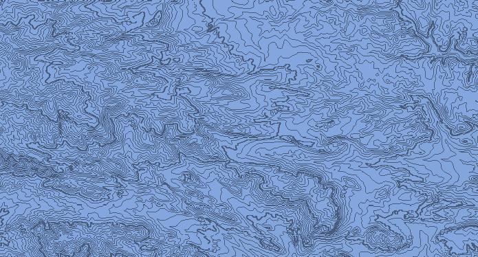

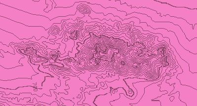
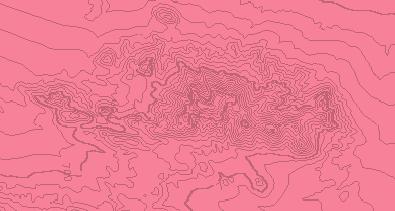
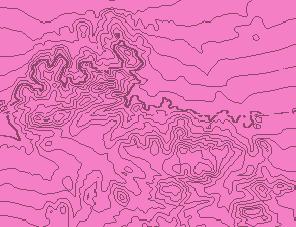
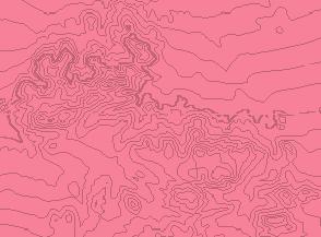
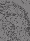
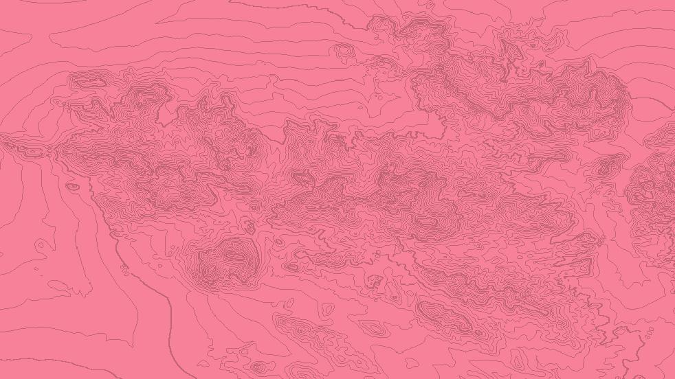
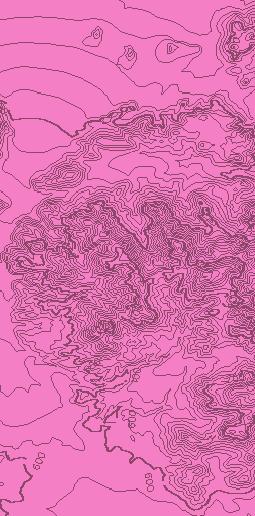
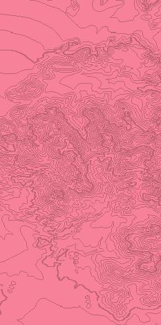
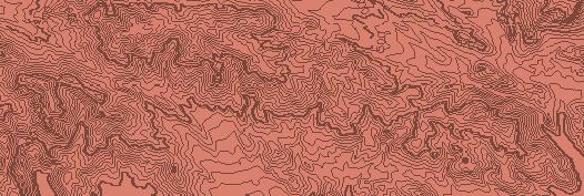
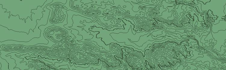
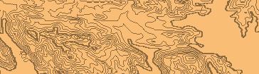
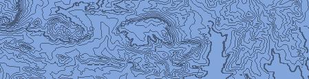
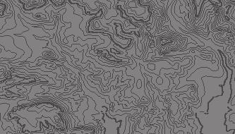
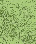
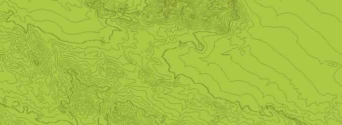
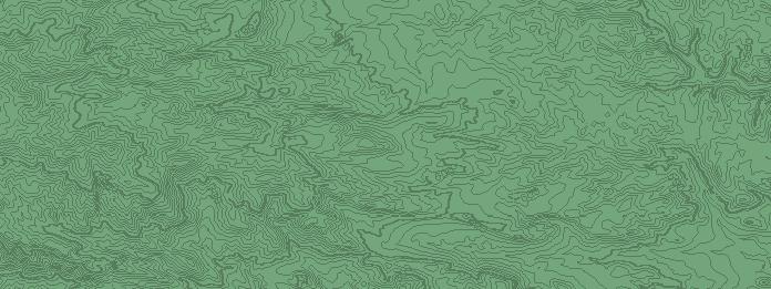
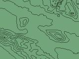
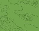
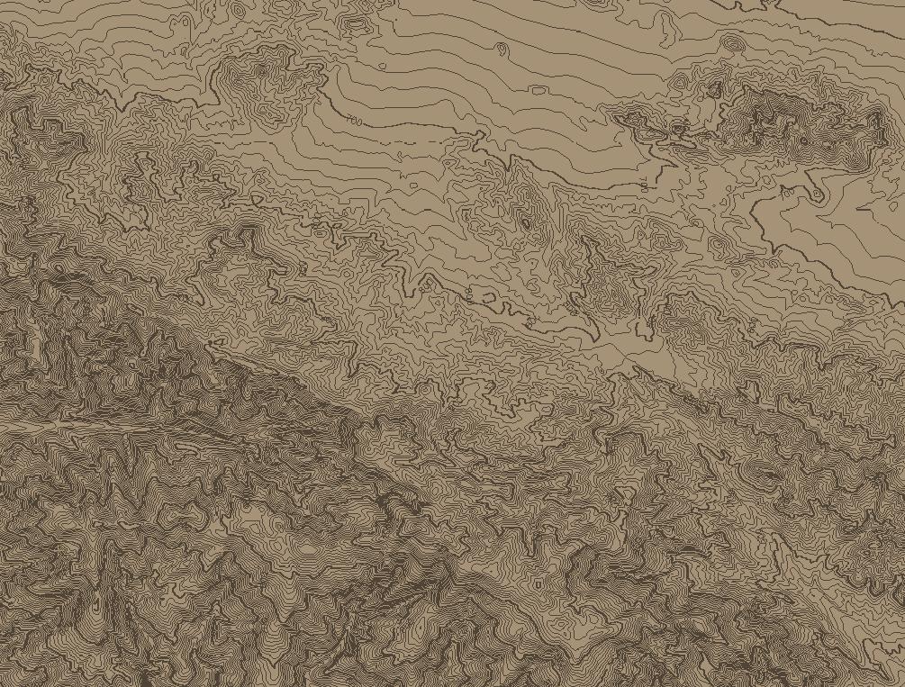
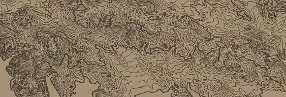
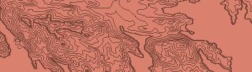
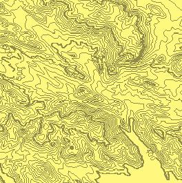
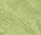
13 A B KTos Td4 Td A Td0 64 Td am oun tain lt KTos Td4 76? Td4 Tertiary (Miocene) Diligencia Formation: Brown and yellow sandstone, siltstone and limestone. Td0 Tertiary (Miocene) Diligencia Formation: Red sandstone and conglomerate. Breccia with large granitic boulders near bottom and top of unit in west. KTos Tertiary (Eocene) Maniobra Formation: Buff marine sandstone and silstone. Breccia with large granitic boulders near base. C Proterozoic-Mesozoic crystalline rocks, including gneiss, leucogranite, anorthosite, gabbro and syenite Cretaceous-Tertiary Orocopia Schist KTos Bedding attitude Fault, showing orientation of slickenline Vertical bedding Fault, showing dip Horizontal bedding Syncline ault D GS CS GEOLOGIC MAP OF DILIGENCIA BASIN AREA, OROCOPIA MOUNTAINS, RIVERSIDE COUNTY, CALIFORNIA RV Ingersoll, MJ Pratt, PM Davis, L Caracciolo, PP Day, PO Hayne, DA Petrizzo, DA Gingrich, W Cavazza, S Critelli, DS Diamond, KT Coffey, DM Stang, JF Hoyt, RC Reith and ED Hendrix (14) Overturned bedding km Gravity Survey Line with dot showing model fault location Magnetics Survey Line with dot showing model fault location We ll f 86 Reverse fault Overturned anticline 14 Anticline; dashed where approximate, dotted where concealed ens 55 Fault; dashed where approximate, dotted where concealed 8 Cle m Contact; dashed where approximate, dotted where concealed Tertiary (Miocene) Diligencia Formation: Volcanic unit. Basalt flows and andesite intrusives. Tertiary (Miocene) Diligencia Formation: Gray to reddish conglomerate with sandstone Orocopia Mountains detachment fault Tertiary (Miocene) Diligencia Formation: Blue, green, yellow, tan and purple silstone and limestone with minor sandstone and evaporites. Tertiary (Miocene) Diligencia Formation: Red sandstone and conglomerate Dominantly Proterozoic augen gneiss Clemens Well fault Mesozoic granitoids ? Tertiary-Quaternary alluvial and terrace deposits Td4 B 46 KTos t Td0 43 ul fa 68 fau 49 Td cia en ent hm tac s de 56 lig Di Td0 Td cop i Oro RC D rv ey s Su C rv ey s. Su 09 Contour Interval : 10 meters Topographic map prepared by Paul Hayne and Mark Pratt with USGS NED 1/3 Arc Second data University of California, Los Angeles N GSA Data Repository item #146 Ingersoll, R.V., et al., 14, Paleotectonics of a complex Miocene half graben formed above a detachment fault: The Diligencia basin, Orocopia Mountains, southern California: Lithopshere, doi:10.11/l3.1.
Jonathan A. Nourse Department of Geological Sciences California State Polytechnic University Pomona, CA
 Comparison of Late Cretaceous Plutonic Rocks Across the Left-Lateral San Antonio Canyon Fault, San Gabriel Mountains Daniel E. Heaton Department of Geological Sciences San Diego State University San Diego,
Geochronology of Catalina Island Schist and Future Work. Island Schist, we look into geochronological data to constrain the timeline of various
 Maria delos Angeles Cuevas May 4, 2015 Professor John Platt Geochronology of Catalina Island Schist and Future Work Abstract Taking into consideration the various issues involving the exhumation of Catalina
Basin & Range / Mojave Desert
 Basin & Range / Mojave Desert Basin & Range vs. Great Basin 1 2/20/2016 An overview of the last horst Basin and Range / Mojave Desert Summary: Granitic, volcanic, marine sedimentary, non marine sedimentary,
Topics Laramide Orogeny: Late Cretaceous to Early Eocene Reading: GSA DNAG volume 3, Ch. 6
 Topics Laramide Orogeny: Late Cretaceous to Early Eocene Reading: GSA DNAG volume 3, Ch. 6 Late Cretaceous to early Eocene New patterns developed 5 main regions Tectonic interpretations Post-Laramide events
Formation, evolution, and inversion of the middle Tertiary Diligencia basin, Orocopia Mountains, southern California
 Formation, evolution, and inversion of the middle Tertiary Diligencia basin, Orocopia Mountains, southern California Richard D. Law* Kenneth Eriksson Cole Davisson Department of Geological Sciences, Virginia
Data Repository Item
 Data Repository Item Exhumation of the Orocopia Schist and associated rocks of southeastern California: Relative roles of erosion, synsubduction tectonic denudation, and middle Cenozoic extension Carl
Chapter 3. Geology & Tectonics
 Chapter 3 Geology & Tectonics 3.1 Geology The general geological features of Indonesia are shown in Figure 3.1. The basement formation is metamorphic and it is intruded with plutonic formations. They are
Geology (Mellow) Hike, Santa Lucia Memorial Park February 16, I. Overview of Santa Lucia Range geology and tectonic history
 Hike, Santa Lucia Memorial Park February 16, I. Overview of Santa Lucia Range geology and tectonic history") Geology (Mellow) Hike, Santa Lucia Memorial Park February 16, 2015 I. Overview of Santa Lucia Range geology and tectonic history A. Basement Rocks 1. Salinian Block Rocks Sierra Nevada Type, continental
Geology (Mellow) Hike, Santa Lucia Memorial Park February 16, 2015 I. Overview of Santa Lucia Range geology and tectonic history A. Basement Rocks 1. Salinian Block Rocks Sierra Nevada Type, continental
Earth Science, (Tarbuck/Lutgens) Chapter 10: Mountain Building
 Chapter 10: Mountain Building") Earth Science, (Tarbuck/Lutgens) Chapter 10: Mountain Building 1) A(n) fault has little or no vertical movements of the two blocks. A) stick slip B) oblique slip C) strike slip D) dip slip 2) In a(n) fault,
Earth Science, (Tarbuck/Lutgens) Chapter 10: Mountain Building 1) A(n) fault has little or no vertical movements of the two blocks. A) stick slip B) oblique slip C) strike slip D) dip slip 2) In a(n) fault,
Structural deformation across the southwest Mina deflection, California-Nevada: Field studies in the Huntoon Springs area.
 Structural deformation across the southwest Mina deflection, California-Nevada: Field studies in the Huntoon Springs area. Eliya R. Hogan Advisor: Jeff Lee Introduction and purpose of study: The Mina deflection
Structural Geology Lab. The Objectives are to gain experience
 Geology 2 Structural Geology Lab The Objectives are to gain experience 1. Drawing cross sections from information given on geologic maps. 2. Recognizing folds and naming their parts on stereoscopic air
Answers: Internal Processes and Structures (Isostasy)
") Answers: Internal Processes and Structures (Isostasy) 1. Analyse the adjustment of the crust to changes in loads associated with volcanism, mountain building, erosion, and glaciation by using the concept
Answers: Internal Processes and Structures (Isostasy) 1. Analyse the adjustment of the crust to changes in loads associated with volcanism, mountain building, erosion, and glaciation by using the concept
Tectonic history of the Los Angeles Basin: Understanding what formed and deforms the city of. Los Angeles. Anne Rosett
 Rosett 1 Tectonic history of the Los Angeles Basin: Understanding what formed and deforms the city of Los Angeles Anne Rosett The Los Angeles (LA) Basin is located in a tectonically complex region which
Chapter 3 Miocene Geology of eastern Santa Cruz Island, California
 Chapter 3 Miocene Geology of eastern Santa Cruz Island, California NICOLE LONGINOTTI A* AND ELEANOR S. BARTOLOMEO B A DEPARTMENT OF GEOLOGY B CIVIL & ENVIRONMENTAL ENGINEERING UNIVERSITY OF CALIFORNIA,
Lower arc crust A review of some important exhumed crustal sections and xenolith localities from the Americas
 Lower arc crust A review of some important exhumed crustal sections and xenolith localities from the Americas Mihai Ducea University of Arizona For the ExTerra group workshop August, 24, 2013, Florence,
Parts of the Sevier/ Laramide Orogeny
 Parts of the Sevier/ Laramide Orogeny AA. Accretionary Prism BB. Forearc Basin Sediment scraped off of subducting plate Sediment derived from the volcanic arc CC. Volcanic Arc Magmatic intrusion into the
UNDERSTANDING GEOLOGIC M APS
 Name: Lab Section: work in groups, but each person turns in his/her own GEOSCIENCE 001 L AB UNDERSTANDING GEOLOGIC M APS Geologic maps are colorful and even beautiful, but they also contain an amazing
Strike-Slip Faults. ! Fault motion is parallel to the strike of the fault.
 Strike-Slip Faults! Fault motion is parallel to the strike of the fault.! Usually vertical, no hanging-wall/footwall blocks.! Classified by the relative sense of motion. " Right lateral opposite block
Paleotectonics of a complex Miocene half graben formed above a detachment fault: The Diligencia basin, Orocopia Mountains, southern California
 RESEARCH Paleotectonics of a complex Miocene half graben formed above a detachment fault: The Diligencia basin, Orocopia Mountains, southern California Raymond V. Ingersoll 1, *, Mark J. Pratt 1, Paul
Structural Styles and Geotectonic Elements in Northwestern Mississippi: Interpreted from Gravity, Magnetic, and Proprietary 2D Seismic Data
 Structural Styles and Geotectonic Elements in Northwestern Mississippi: Interpreted from Gravity, Magnetic, and Proprietary 2D Seismic Data Nick Loundagin 1 and Gary L. Kinsland 2 1 6573 W. Euclid Pl.,
Geology 300, Physical Geology Spring 2019 Quiz Ch 19, Plate Tectonics Name
 Geology 300, Physical Geology Spring 2019 Quiz Ch 19, Plate Tectonics Name MULTIPLE CHOICE. Choose the one alternative that best completes the statement or answers the question. 1) The portion of a fracture
Hosgri-San Simeon Fault Zone Geologic Slip Rate
 Hosgri-San Simeon Fault Zone Geologic Slip Rate Insert picture(s) here Kathryn Hanson AMEC E&I Diablo Canyon SSHAC Project SSC Workshop 2 November 7, 2012 What insights have your geologic investigations
Geologic History of Texas: The Making of Texas Over 1.5 Billion Years
 # 4 Geologic History of Texas: The Making of Texas Over 1.5 Billion Years Dr. Richard Kyle March 24, 2000 Produced by and for Hot Science - Cool Talks by the Environmental Science Institute. We request
Copyright McGraw-Hill Education. All rights reserved. No reproduction or distribution without the prior written consent of McGraw-Hill Education
 Copyright McGraw-Hill Education. All rights reserved. No reproduction or distribution without the prior written consent of McGraw-Hill Education Tibetan Plateau and Himalaya -southern Asia 11.00.a VE 10X
In this lab, we will study and analyze geologic maps from a few regions, including the Grand Canyon, western Wyoming, and coastal California.
 Name: Lab Section: work in groups, but each person turns in his/her own GEOSCIENCE 001 LAB UNDERSTANDING GEOLOGIC MAPS Geologic maps are colorful and even beautiful, but they also contain an amazing amount
A Source-to-Sink Approach to Drainage and Sediment Flux in Thrust and Foreland Systems Utah-Wyoming- Colorado, US Rockies*
 A Source-to-Sink Approach to Drainage and Sediment Flux in Thrust and Foreland Systems Utah-Wyoming- Colorado, US Rockies* Ole J. Martinsen 1 Search and Discovery Article #51315 (2016)** Posted October
Cenozoic Extensional Basin Development and Sedimentation in SW Montana
 Cenozoic Extensional Basin Development and Sedimentation in SW Montana Robert C. Thomas Department of Environmental Sciences, The University of Montana Western, Dillon, MT 59725, (406) 683-7615, r_thomas@umwestern.edu
Global Tectonics. Kearey, Philip. Table of Contents ISBN-13: Historical perspective. 2. The interior of the Earth.
 Global Tectonics Kearey, Philip ISBN-13: 9781405107778 Table of Contents Preface. Acknowledgments. 1. Historical perspective. 1.1 Continental drift. 1.2 Sea floor spreading and the birth of plate tectonics.
Governor Mine. Geologic Information. Mineral Resources On-Line Spatial Data
 Mineral Resources On-Line Spatial Data Governor Mine Past Producer in Los Angeles county in California, United States with commodities Gold, Silver, Copper Geologic Information Identification information
Tectonic Framework of New York State
 Tectonic Framework of New York State Kurt Hollocher Union College Geology Department Talk given for the UCALL program Union College, Schenectady, NY April 3, 2007 New York State Geological Highway Map.
Meandering Miocene Deep Sea Channel Systems Offshore Congo, West Africa
 Meandering Miocene Deep Sea Channel Systems Offshore Congo, West Africa S. Baer* (PGS), J. E. Comstock (PGS), K. Vrålstad (PGS), R. Borsato (PGS), M. Martin (PGS), J.P. Saba (SNPC), B. Débi-Obambé (SNPC)
KEY CHAPTER 12 TAKE-HOME QUIZ INTERNAL STRUCTURES AND PROCESSES Score Part B = / 55 PART B
 GEOLOGY 12 KEY CHAPTER 12 TAKE-HOME QUIZ INTERNAL STRUCTURES AND PROCESSES Score Part B = / 55 PART B CHAPTER 12 Isostacy and Structural Geology 1. Using the terms below, label the following diagrams and
GENERAL GEOLOGY Fall Chapter 18: The Sea Floor. Partial Examination IV Study Guide Dr. Glen S. Mattioli
 GENERAL GEOLOGY 1113-005 Fall 2008 Partial Examination IV Study Guide Dr. Glen S. Mattioli Note that these are NOT questions, but rather are a list of topics that we have covered either in class or are
The Monterey Submarine Canyon and Fan
 Chapter 72 The Monterey Submarine Canyon and Fan Monterey Canyon, California, is probably the most studied submarine canyon in the world (Figure 72.1). Since it is typical of many others it is useful as
Structural Geology Lab. The Objectives are to gain experience
 Geology 2 Structural Geology Lab The Objectives are to gain experience 1. Drawing cross sections from information given on geologic maps. 2. Recognizing folds and naming their parts on stereoscopic air
Geologic Structures. Changes in the shape and/or orientation of rocks in response to applied stress
 Geologic Structures Changes in the shape and/or orientation of rocks in response to applied stress Figure 15.19 Can be as big as a breadbox Or much bigger than a breadbox Three basic types Fractures >>>
Geology 15 West Valley College. Exam IV: Sierra Nevada
 Geology 15 West Valley College Name Exam IV: Sierra Nevada 1) On the diagram above, where is the Arc- Trench Gap? a. 1 and 3 c. 7 and 8 d. 6 e. 5 and 10 2) On the diagram above, where is the subduction
Crustal Deformation. Earth Systems 3209
 Crustal Deformation Earth Systems 3209 Crustal Deformation pg. 415 Refers to all changes in the original form and/or size of a rock body. May also produce changes in the location and orientation of rocks.
Before Plate Tectonics: Theory of Continental Drift
 Before Plate Tectonics: Theory of Continental Drift Predecessor to modern plate tectonics Shape and fit of the continents was the initial evidence Snider-Pelligrini (1858) Taylor (1908) Wegner (1915) Fig.
Structures that accommodated differential vertical axis rotation of the western Transverse Ranges, California
 TECTONICS, VOL. 24,, doi:10.1029/2004tc001769, 2005 Structures that accommodated differential vertical axis rotation of the western Transverse Ranges, California Nathan W. Onderdonk 1 Department of Geological
The Mesozoic. Wednesday, November 30, 11
 The Mesozoic Periods of the Mesozoic Triassic- First period of the Mesozoic era Jurassic Cretaceous- Last period of the Mesozoic era Breakup of Pangaea Stage one (Triassic) Rifting and volcanism, normal
Geologic Trips San Francisco and the Bay Area
 Excerpt from Geologic Trips San Francisco and the Bay Area by Ted Konigsmark ISBN 0-9661316-4-9 GeoPress All rights reserved. No part of this book may be reproduced without written permission in writing,
Hildebrand Analysis: Topic 4
 Steven Plescia 12/9/16 Hildebrand Analysis: Topic 4 Hildebrand interprets much of the classic late pc-paloezoic Cordilleran miogeocline as exotic to North America Is there a break in the detrital zircons
7 Sedimentation and tectonics at a mid- Ordovician to Silurian active margin
 80 Mountain Building in Scotland 7 Sedimentation and tectonics at a mid- Ordovician to Silurian active margin 7.1 Introduction In mid-ordovician to Silurian times, the Grampian mountains underwent exhumation,
Cenozoic Earth History I
 Cenozoic Earth History I Cenozoic plate tectonics Tertiary, Quaternary, Paleogene, Neogene Tejas Transgression North America s east coast geology Laramide Orogeny Post-Laramide mountain building and volcanism
Crustal Boundaries. As they move across the asthenosphere and form plate boundaries they interact in various ways. Convergent Transform Divergent
 Name: Date: Period: Plate Tectonics The Physical Setting: Earth Science CLASS NOTES Tectonic plates are constantly moving and interacting As they move across the asthenosphere and form plate boundaries
General Geologic Setting and Seismicity of the FHWA Project Site in the New Madrid Seismic Zone
 General Geologic Setting and Seismicity of the FHWA Project Site in the New Madrid Seismic Zone David Hoffman University of Missouri Rolla Natural Hazards Mitigation Institute Civil, Architectural & Environmental
Chapter 16. Mountain Building. Mountain Building. Mountains and Plate Tectonics. what s the connection?
 Chapter 16 Mountains and Plate Tectonics what s the connection? Mountain Building Most crustal deformation occurs along plate margins. S.2 Active Margin Passive Margin Mountain Building Factors Affecting
Summary. Study Area. Data Acquisition
 Evidence for hyper-extended continental crust in the East Orphan Basin from seismic reflection data and potential field forward modelling and inversion J. Kim Welford 1, Deric Cameron 2, James Carter 2
Demasking Multiple Artifact in Crustal Seismic Images from Marine Reflection Data in the Southern California Borderland
 Journal of Earth Science, Vol. 26, No. 4, p. 592 597, August 2015 ISSN 1674-487X Printed in China DOI: 10.1007/s12583-015-0558-3 Demasking Multiple Artifact in Crustal Seismic Images from Marine Reflection
Questions and Topics
 Plate Tectonics and Continental Drift Questions and Topics 1. What are the theories of Plate Tectonics and Continental Drift? 2. What is the evidence that Continents move? 3. What are the forces that
Basin Analysis. Stra-graphy
 Basin Analysis Stra-graphy Basin Analysis Basin analysis integrates program sedimentological, stra-graphic, and tectonic principals to develop a full understanding of the rocks that fill sedimentary basins.
The Blue Mountains: The Ochocos The Wallowas (The Strawberries)...
...") The Blue Mountains: The Ochocos The Wallowas (The Strawberries)... 46 Dorsey & LaMaskin 2007 47 The Wallowa Mountains: Four Plutons 123-140 Ma 4 48 Hell s Canyon: Columbia River Basalt Group unconformably
The Blue Mountains: The Ochocos The Wallowas (The Strawberries)... 46 Dorsey & LaMaskin 2007 47 The Wallowa Mountains: Four Plutons 123-140 Ma 4 48 Hell s Canyon: Columbia River Basalt Group unconformably
GEOLOGIC MAPS PART II
 EARTH AND ENVIRONMENT THROUGH TIME LABORATORY - EES 1005 LABORATORY FIVE GEOLOGIC MAPS PART II Introduction Geologic maps of orogenic belts are much more complex than maps of the stable interior. Just
Name Student ID Exam 2c GEOL 1113 Fall 2009
 Name Student ID Exam 2c GEOL 1113 Fall 2009 1. When a marine geologist collects a core of undeformed ocean-floor sediment, she knows that the youngest layer is on the top of the core and the oldest is
Structure of the western Brooks Range fold and thrust belt, Arctic Alaska
 Trabajos de Geología, Universidad de Oviedo, 29 : 218-222 (2009) Structure of the western Brooks Range fold and thrust belt, Arctic Alaska J. DE VERA 1* AND K. MCCLAY 2 1Now at: Shell, Rijswijk, Netherlands.
Lisa Gaston NMT. Photo courtesy of Mike Williams. Matt Heizler
 Lisa Gaston NMT Photo courtesy of Mike Williams Matt Heizler Precambrian Geology Field Area 40 Ar/ 39 Ar results Do the pegmatites record intrusion ages? Conclusions Future work Precambrian provinces of
Seismic refraction evidence for steep faults cutting highly attenuated continental basement in the central Transverse ranges, California
 Geophys. J. Int. (5) 6, 65 666 doi:./j.365-46x.5.56.x Seismic refraction evidence for steep faults cutting highly attenuated continental basement in the central Transverse ranges, California Zhimei Yan,
ENVI.2030L Geologic Time
 Name ENVI.2030L Geologic Time I. Introduction There are two types of geologic time, relative and absolute. In the case of relative time geologic events are arranged in their order of occurrence. No attempt
Deformation History of a Major Restraining Bend along a Right-Slip Fault: The San Clemente Fault Offshore Northern Baja California, Mexico
 Deformation History of a Major Restraining Bend along a Right-Slip Fault: The San Clemente Fault Offshore Northern Baja California, Mexico REPORT The main focus of this project was to investigate the deformation
Blocks 31, 32, 33, 34, 35 & 36/03 Southeast Offshore Vietnam
 Blocks 31, 32, 33, 34, 35 & 36/03 Southeast Offshore Vietnam Block 31 32 33 34 35 36/03 Area (km 2) 5,036 4,440 4,630 4,700 4,630 2,950 Sea level (m) 20 20-30 30-40 50 50 50 Seismic 2D (km) 1,294 685 431
LAB 6: TRINIDAD BEACH FIELD TRIP
 OBJECTIVES: LAB 6: TRINIDAD BEACH FIELD TRIP 1) to develop your powers of observation, especially of geological phenomena; 2) to identify the rocks exposed at Trinidad Beach; 3) to reconstruct some of
Essentials of Geology, 11e
 Essentials of Geology, 11e Crustal Deformation and Mountain Building Chapter 17 Instructor Jennifer Barson Spokane Falls Community College Geology 101 Stanley Hatfield Southwestern Illinois College Jennifer
6. In the diagram below, letters A and B represent locations near the edge of a continent.
 1. Base your answer to the following question on the cross section below and on your knowledge of Earth science. The cross section represents the distance and age of ocean-floor bedrock found on both sides
Description of faults
 GLG310 Structural Geology Description of faults Horizontal stretch Crustal thickness Regional elevation Regional character Issues Normal Thrust/reverse Strike-slip >1 1 in one direction and < 1 in
Mesozoic Earth History
 Mesozoic Earth History The Mesozoic Era 251-66 MYA Breakup of Pangea Changes in air and oceanic currents Evolution of new terrestrial and marine life Opening of the Atlantic Ocean Basin Rocky Mountains
GLY 155 Introduction to Physical Geology, W. Altermann. Press & Siever, compressive forces. Compressive forces cause folding and faulting.
 Press & Siever, 1995 compressive forces Compressive forces cause folding and faulting. faults 1 Uplift is followed by erosion, which creates new horizontal surface. lava flows Volcanic eruptions cover
Bathymetry Measures the vertical distance from the ocean surface to mountains, valleys, plains, and other sea floor features
 1 2 3 4 5 6 7 8 9 10 11 CHAPTER 3 Marine Provinces Chapter Overview The study of bathymetry determines ocean depths and ocean floor topography. Echo sounding and satellites are efficient bathymetric tools.
Chapter 15 Structures
 Chapter 15 Structures Plummer/McGeary/Carlson (c) The McGraw-Hill Companies, Inc. TECTONIC FORCES AT WORK Stress & Strain Stress Strain Compressive stress Shortening strain Tensional stress stretching
Petroleum geology framework, West Coast offshore region
 Petroleum geology framework, West Coast offshore region James W. Haggart* Geological Survey of Canada, Vancouver, BC jhaggart@nrcan.gc.ca James R. Dietrich Geological Survey of Canada, Calgary, AB and
Continental Landscapes
 Continental Landscapes Landscape influenced by tectonics, climate & differential weathering Most landforms developed within the last 2 million years System moves toward an equilibrium Continental Landscapes
Overview of the Seismic Source Characterization for the Palo Verde Nuclear Generating Station
 Overview of the Seismic Source Characterization for the Palo Verde Nuclear Generating Station Scott Lindvall SSC TI Team Lead Palo Verde SSC SSHAC Level 3 Project Tuesday, March 19, 2013 1 Questions from
ATTACHMENT Q PALEONTOLOGICAL RESOURCES REPORT
 ATTACHMENT Q PALEONTOLOGICAL RESOURCES REPORT LaRamie Soils Service, Inc. 217B Grand Avenue, Suite 1 P.O. Box 255 Laramie, WY 82073 geomorph@laramiesoils.com PALEONTOLOGICAL EVALUATION LANCASTER ENERGY
Before 2 billion years -?? no rocks preserved
 California Geology California Geology Science Content Standards for California Public Schools 6 th Grade Focus on Earth Sciences Students know how to explain major features of California geology (including
Deformation of Rocks. Orientation of Deformed Rocks
 Deformation of Rocks Folds and faults are geologic structures caused by deformation. Structural geology is the study of the deformation of rocks and its effects. Fig. 7.1 Orientation of Deformed Rocks
Controls on clastic systems in the Angoche basin, Mozambique: tectonics, contourites and petroleum systems
 P2-2-13 Controls on clastic systems in the Angoche basin, Mozambique: tectonics, contourites and petroleum systems Eva Hollebeek, Olivia Osicki, Duplo Kornpihl Schlumberger, London, UK Introduction Offshore
Mesozoic Tectonics of the Blue Mountains Province
 Mesozoic Tectonics of the Blue Mountains Province Main Events Middle Triassic: normal subduction and facing arcs Late Triassic: arc-arc collision (?) Jurassic: long-lived terrane-continent collision (?)
Map shows 3 main features of ocean floor
 Map shows 3 main features of ocean floor 2017 Pearson Education, Inc. Chapter 3 Marine Provinces 2017 Pearson Education, Inc. 1 Chapter 3 Overview The study of bathymetry determines ocean depths and ocean
Learning Objectives (LO) What we ll learn today:!
 What we ll learn today:!") Learning Objectives (LO) Lecture 13: Mountain Building Read: Chapter 10 Homework #11 due Tuesday 12pm What we ll learn today:! 1. Define the types of stress that are present in the crust! 2. Define the
Learning Objectives (LO) Lecture 13: Mountain Building Read: Chapter 10 Homework #11 due Tuesday 12pm What we ll learn today:! 1. Define the types of stress that are present in the crust! 2. Define the
A 2-D Petroleum System Model for the Vallecitos Syncline, San Joaquin Basin, California *
 A 2-D Petroleum System Model for the Vallecitos Syncline, San Joaquin Basin, California * Meng He 1, Stephan Graham 1, J. Michael Moldowan 1, Kenneth E. Peters 1, Leslie B. Magoon 1, Carolyn Lampe 1, and
Lab 1: Plate Tectonics April 2, 2009
 Name: Lab 1: Plate Tectonics April 2, 2009 Objective: Students will be introduced to the theory of plate tectonics and different styles of plate margins and interactions. Introduction The planet can be
Chapter Overview. Bathymetry. Measuring Bathymetry. Measuring Bathymetry
 CHAPTER 3 Marine Provinces Chapter Overview The study of bathymetry determines ocean depths and ocean floor topography. Echo sounding and satellites are efficient bathymetric tools. Most ocean floor features
11.1 Rock Deformation
 Tarbuck Lutgens Mountain Building 11.1 Rock Deformation Factors Affecting Deformation Factors that influence the strength of a rock and how it will deform include temperature, confining pressure, rock
The Sorong Fault Zone Kinematics: The Evidence of Divergence and Horsetail Structure at NW Bird's Head and Salawati Basin, West Papua, Indonesia*
 The Sorong Fault Zone Kinematics: The Evidence of Divergence and Horsetail Structure at NW Bird's Head and Salawati Basin, West Papua, Indonesia* Putri Riadini 1 and Benyamin Sapiie 2 Search and Discovery
Convergent plate boundary.
 Crustal Deformation Convergent plate boundary http://my.execpc.com/~acmelasr/mountains/geogramsnf.html Plate Tectonic Settings and Magma Where plates CONVERGE, water is driven off the subducting plate,
MAR110 Lecture #5 Plate Tectonics-Earthquakes
 1 MAR110 Lecture #5 Plate Tectonics-Earthquakes Figure 5.0 Plate Formation & Subduction Destruction The formation of the ocean crust from magma that is upwelled into a pair of spreading centers. Pairs
There are numerous seams on the surface of the Earth
 Plate Tectonics and Continental Drift There are numerous seams on the surface of the Earth Questions and Topics 1. What are the theories of Plate Tectonics and Continental Drift? 2. What is the evidence
Plate Tectonics. Structure of the Earth
 Plate Tectonics Structure of the Earth The Earth can be considered as being made up of a series of concentric spheres, each made up of materials that differ in terms of composition and mechanical properties.
New Mexico Geological Society
 New Mexico Geological Society Downloaded from: http://nmgs.nmt.edu/publications/guidebooks/26 Tectonic significance of the Pony Hills, Luna County, New Mexico LeRoy L. Corbitt and Fred L. Nials, 1975,
A) B) C) D) 4. Which diagram below best represents the pattern of magnetic orientation in the seafloor on the west (left) side of the ocean ridge?
 B) C) D) 4. Which diagram below best represents the pattern of magnetic orientation in the seafloor on the west (left) side of the ocean ridge?") 1. Crustal formation, which may cause the widening of an ocean, is most likely occurring at the boundary between the A) African Plate and the Eurasian Plate B) Pacific Plate and the Philippine Plate C)
1. Crustal formation, which may cause the widening of an ocean, is most likely occurring at the boundary between the A) African Plate and the Eurasian Plate B) Pacific Plate and the Philippine Plate C)
December 21, Chapter 11 mountain building E.notebook. Feb 19 8:19 AM. Feb 19 9:28 AM
 Mountains form along convergent plate boundaries. Typically (usually) if you look at a mountain range, you know that it is at a plate boundary (active continental margin) or has been some time in the past
Today: Basic regional framework. Western U.S. setting Eastern California Shear Zone (ECSZ) 1992 Landers EQ 1999 Hector Mine EQ Fault structure
 1992 Landers EQ 1999 Hector Mine EQ Fault structure") Today: Basic regional framework Western U.S. setting Eastern California Shear Zone (ECSZ) 1992 Landers EQ 1999 Hector Mine EQ Fault structure 1 2 Mojave and Southern Basin and Range - distribution of strike-slip
Today: Basic regional framework Western U.S. setting Eastern California Shear Zone (ECSZ) 1992 Landers EQ 1999 Hector Mine EQ Fault structure 1 2 Mojave and Southern Basin and Range - distribution of strike-slip
PRESERVATION OF A SUBDUCTION-RELATED GEOTHERMAL GRADIENT IN THE SCHIST OF SIERRA DE SALINAS, CENTRAL CALIFORNIA COAST RANGES
 Published by Keck Geology Consortium Short Contributions 30th Annual Symposium Volume 29th April, 2017 ISBN: 1528-7491 PRESERVATION OF A SUBDUCTION-RELATED GEOTHERMAL GRADIENT IN THE SCHIST OF SIERRA DE
Directed Reading. Section: How Mountains Form MOUNTAIN RANGES AND SYSTEMS. Skills Worksheet
 Skills Worksheet Directed Reading Section: How Mountains Form 1. How high is Mount Everest? a. about 1980 km above sea level b. more than 8 km below sea level c. more than 8 km above sea level d. more
Structural Style and Tectonic Evolution of the Nakhon Basin, Gulf of Thailand
 Structural Style and Tectonic Evolution of the Nakhon Basin, Gulf of Thailand Piyaphong Chenrai Petroleum Geoscience Program, Department of Geology, Faculty of Science, Chulalongkorn University, Bangkok
New Mexico Geological Society
 New Mexico Geological Society Downloaded from: http://nmgs.nmt.edu/publications/guidebooks/27 Structural framework of the southern Raton Basin, New Mexico Lee A. Woodward and D. O. Snyder, 1976, pp. 125-127
12. The diagram below shows the collision of an oceanic plate and a continental plate.
 Review 1. Base your answer to the following question on the cross section below, which shows the boundary between two lithospheric plates. Point X is a location in the continental lithosphere. The depth
The Lithosphere and the Tectonic System. The Structure of the Earth. Temperature 3000º ºC. Mantle
 The Lithosphere and the Tectonic System Objectives: Understand the structure of the planet Earth Review the geologic timescale as a point of reference for the history of the Earth Examine the major relief
Mark Legg COASTAL DEFORMATION AND TECTONIC EVOLUTION OFFSHORE SAN ONOFRE
 COASTAL DEFORMATION AND TECTONIC EVOLUTION OFFSHORE SAN ONOFRE August 2013 Coastal Deformation and Tectonic Evolution Offshore San Onofre Mark R. Legg Legg Geophysical, Inc. The true sign of intelligence
Crustal Activity. Plate Tectonics - Plates - Lithosphere - Asthenosphere - Earth s surface consists of a major plates and some minor ones
 Name: Date: Period: Tectonics The Physical Setting: Earth Science CLASS NOTES Tectonics - s - Lithosphere - Asthenosphere - Earth s surface consists of a major plates and some minor ones The plates are