Subglacial bedforms of the Irish Ice Sheet
|
|
|
- Hubert Day
- 6 years ago
- Views:
Transcription


1 Journal of Maps ISSN: (Print) (Online) Journal homepage: Subglacial bedforms of the Irish Ice Sheet Sarah L. Greenwood & Chris D. Clark To cite this article: Sarah L. Greenwood & Chris D. Clark (2008) Subglacial bedforms of the Irish Ice Sheet, Journal of Maps, 4:1, , DOI: /jom To link to this article: Copyright Taylor and Francis Group, LLC View supplementary material Published online: 23 Jan Submit your article to this journal Article views: 368 View related articles Citing articles: 37 View citing articles Full Terms & Conditions of access and use can be found at Download by: [ ] Date: 02 December 2017, At: 10:46
2 Subglacial bedforms of the Irish Ice Sheet SARAH L. GREENWOOD 1,2 and CHRIS D. CLARK 1 1 Department of Geography, University of Sheffield, Winter Street, Sheffield S10 2TN, UK; sarah.greenwood@natgeo.su.se 2 Department of Physical Geography and Quaternary Geology, Stockholm University, Stockholm, SWEDEN. (Received 7 th July 2008; Revised 30 th October 2008; Accepted 4 th November 2008) Abstract: The last Irish Ice Sheet has a long history of investigation, but its most basic properties are still debated. A palaeo-glaciological inversion of the glacial geomorphological record has elsewhere proven an effective means to reconstruct former ice sheets at ice sheet scale. To this end, this paper describes new glacial geomorphological mapping of the Irish landscape, using Digital Elevation Models, Landsat ETM+ and SPOT satellite images, with the objective of achieving a thorough and systematic documentation of the form, spatial distribution and arrangement of glacial landforms in Ireland. A resulting map, presented here at a scale of 1:425,000, identifies 33,000 subglacial bedforms. Glacial lineations (drumlins, mega-scale glacial lineations and crag and tails) and ribbed moraine comprise the bulk of the bedform population, although a wide spectrum of bedform types, shapes and sizes is observed. In particular, a suite of enigmatic bedforms were mapped which were not classified either as streamlined lineations or transverse ridges; rather, they are quasi-circular in form. This map is the first to document the subglacial bedform record of Ireland at the scale of individual landforms, and countrywide. In so doing, it reveals the extent and complexity of superimposed and cross-cutting bedform relationships, which demand an ice sheet reconstruction depicting marked changes in ice sheet geometry, configuration and behaviour through its evolution. This map forms the basis for a palaeo-glaciological reconstruction which addresses and attempts to incorporate the complexity of ice flow history revealed by the subglacial bedforms of Ireland. ISSN
3 1. Introduction A fundamental problem in understanding contemporary ice sheet dynamics is the slow evolution of an ice sheet. We can only observe a short snapshot of activity in a much longer cycle of evolution. However, continental-scale ice sheets have waxed and waned throughout the Quaternary period, particularly across the northern hemisphere mid-latitudes, leaving a record of their evolution in the landscape. Quaternary ice sheet reconstruction therefore provides an opportunity to understand ice sheet behaviour through a full glacial cycle. An inversion of the glacial geomorphological record provides an effective means (though not the sole route of enquiry) to reconstruct former ice sheets at ice sheet scale (e.g. Dyke and Prest, 1987; Boulton and Clark, 1990a;b; Clark, 1997; Kleman and Borgström, 1996; Kleman et al., 1997; 2006). An essential pre-requisite for such an approach is a glacial landform map. This paper presents an attempt to fully and systematically document the subglacial geomorphology of Ireland (the Republic of Ireland and Northern Ireland), in order to yield the desired elements of the palaeo-glaciology of the Irish Ice Sheet. The Irish landscape is rich with evidence of former glaciation, and has been extensively studied for well over 100 years (e.g. Close, 1867; Hull, 1878; McCabe, 2008; Ballantyne et al., 2008; Brooks et al., 2008). Indeed, the terms drumlin and esker are of Irish origin. A comprehensive map of Irish glacial landform distribution has existed since Synge and Stephens (1960) and has been much replicated and updated subsequently (e.g. Synge, 1970; 1979; McCabe, 1985; 1987; 1991; 2008; Knight et al., 2004; Farrell et al., 2005, see Figure 1). Whilst this map (and its subsequent iterations) informs us of the main distribution of landform types, and provides a sense of the main ice flow paths or ice-marginal zones, it does not record individual landforms, and generalises information at the landscape level. This disguises the detailed field observations of glacigenic landforms and deposits which, for many areas, have locally yielded highly detailed information of past glacial environments (e.g. Kinahan and Close, 1872; Farrington, 1936; Synge, 1950; Hill, 1973; Thomas and Summers, 1983; Dardis et al., 1984; McCabe et al., 1984; Warren, 1988; Ó Cofaigh and Evans, 2001b; Hegarty, 2002; Knight, 2003). However, such detailed local observations are spatially fragmented, by virtue of chosen field areas, across the former ice sheet bed. At ice sheet scale, when compared to what is required to constrain a dynamically evolving ice sheet, the documented evidence-base for ice sheet reconstruction is internally inconsistent, patchy and incomplete. 333
4 So u t h ern Ir e la nd E nd M Journal of Maps, 2008, or e ai n striae kames drumlins eskers glacial limits outwash gravels Figure 1. Glacial landform map of Ireland, redrawn from Synge (1979). 334
5 Furthermore, interpretation of the Irish evidence of glaciation seems to be invariably associated with debate and controversy: an offshore extent versus a maximum limit at the Southern Ireland End Moraine (see Figure 1; e.g. Warren, 1991; 1992; Synge, 1969; 1970); major readvances vs steady retreat (e.g. Synge, 1970; 1979; McCabe et al., 1998; Meehan, 2004; 2006); thick ice vs thin ice (e.g. McCabe, 1997; Lambeck, 1996); glaciomarine vs glaciolacustrine or subglacial sedimentation around the present-day Irish coast, particularly in the Irish Sea Basin (e.g. Eyles and McCabe, 1989; Knight, 2001; McCarroll, 2001; Ó Cofaigh and Evans, 2001b;a); and differing representations of the overall ice sheet configuration and history (e.g. Warren, 1992; McCabe, 2008; Brooks et al., 2008). Consequently, despite many recent advances, consensus regarding many characteristics of the last (and previous) ice sheet(s) to engulf Ireland is yet to be achieved. Here, for the first time, we present a countrywide glacial map of Ireland which details individual landforms and their spatial relationships. We take a top-down approach to systematically map glacial landforms throughout Ireland, using a variety of high resolution satellite images and digital elevation models. The Subglacial Bedform Map forms the primary basis for interpreting a new palaeo-glaciological model of the last Irish Ice Sheet. We publish the map here as a basic dataset that underpins our interpretations of ice sheet history which will be presented elsewhere (Greenwood, 2008, and forthcoming papers). 2. Data and Methods 2.1 Primary data The glacial geomorphology of Ireland was mapped digitally from a variety of remotely sensed data. The primary imagery used comprised two Digital Elevation Models (DEMs) and two suites of satellite images; their coverage and basic properties are outlined in Table 1 and Figure 2. A variety of imagery was used in order that the relative merits of each data source (resolution, image visualisation, data quality etc.) were maximised and the limitations mitigated (Clark, 1997; Jansson and Glasser, 2005; Smith and Clark, 2005; Smith and Wise, 2007). Data from the various sources were geocorrected, DEM tiles stitched together as necessary, and processed to 335
6 best visualise the landscape for geomorphological mapping. The Irish National Grid (Transverse Mercator projected coordinate system; spheroid: Airy Modified 1849; datum: Ireland 1965; units: metres) was selected as the base projection for all work and data were geocorrected accordingly. To improve landform detectability and minimise illumination bias (Clark and Meehan, 2001; Smith and Clark, 2005) a standard protocol was employed for landform mapping from the DEMs, using at least three differently illuminated visualisations for any area: a NW solar shading, NE, and a view illuminated from directly overhead ( gradient visualisation of Smith and Clark, 2005). Other directions of solar shading were often explored to best highlight features for accurate mapping. Vertical exaggeration between 3x and 5x was used. Satellite imagery was typically viewed using either solely the panchromatic band, a false colour composite using a variety of band combinations (5,3,2 [R,G,B] typically proved most useful for Landsat ETM+ images, for example), or a hybrid (pan-sharpened) image which transferred the information in a colour composite onto the higher resolution panchromatic image. Draping satellite imagery over a shaded DEM was further found to be a useful tool for landform visualisation (cf. Jansson and Glasser, 2005). 2.2 Ancillary data A number of extra sources of information assisted landform detection and identification of features, providing a degree of quality control over the mapping and ensuring only features with a glacial origin were included. Quaternary geology maps and digital data ( 1:50,000 Republic of Ireland National Soil and Subsoil Survey digital data; 1:250,000 map of the Quaternary geology of Northern Ireland; and 1:625,000 UK surficial sediment digital data) which distinguish till, glaciofluvial material, lake or marine sediments, alluvium, peat, made ground, modern water bodies and bedrock exposed at the surface, make them an invaluable accompaniment to glacial landform mapping (e.g. Figure 3). Solid and structural geological datasets and Ordnance Survey Ireland (OSi) maps at a range of scales helped to ensure a glacial feature was not interpreted where there was clearly an alternative explanation, either geological, structural or due to modern-day land cover or use. In select areas, higher resolution digital elevation data (e.g. OSi 10 m DEM) were used to enhance the clarity of features observed in the primary imagery. Finally, published literature was a key element of mapping quality control and support. For consistency, all 336
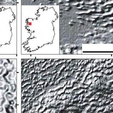
7 Data source Technical properties Spatial resolution Landmap DEM DEM built from ERS 1 and 2 SAR images via interferometry Initial projection 25 m Irish National Grid Useful data coverage Acknowledgement Countrywide MIMAS (University of Manchester-UCL) Shuttle Radar Topographic Mission (SRTM) DEM DEM built by interferometry from shuttle mission 3 arc seconds ( 58 m long, 92 m lat at 51 N) Geographic (lat/long) Countrywide Global Land Cover Facility (University of Maryland) http: //glcf.umiacs.umd.edu/index.shtml Landsat ETM+ Winter scenes (path 207, rows 022, 023, 024) Bands 2,3,4,5 (visible to mid-ir) Panchromatic band (visible and IR) UTM Zones images, 185 x 185 km (see Figure 2) Global Land Cover Facility (University of Maryland) 30 m http: //glcf.umiacs.umd.edu/index.shtml 15 m SPOT Winter scenes (see Fig 2) Bands 1-4 (visible to mid-ir) Panchromatic band (visible) m 2.5 m UTM Zones images, 60 x 60 km (see Figure 2) OASIS programme for SPOT image distribution, c CNES Table 1. Properties of data sources used for landform mapping. 337
8 a b 207, ,240 (SPOT 2) 014,240 (SPOT 1) 207, ,240/7 (SPOT 5) 013,242 (2) 013,242 (4) 014,240/6 (SPOT 5) 018,241/6 (5) 018,241/3 (5) 207, ,244 (5) 013,245 (5) 013,243 (5) 014,245 (5) 013,242/7 (5) 014,244/1 (5) Figure 2. Data coverage of imagery used for geomorphic mapping in Ireland. Two DEMs cover the whole land area (i.e. black coastline). All available winter, cloud-free Landsat ETM+ (a) and SPOT (b) imagery was employed (full coverage unavailable). Path and row numbers as labelled. previously mapped areas were remapped, but published literature provided a useful guide and check on the mapping conducted here. 2.3 Mapping A repeat-pass procedure was adopted in order to ensure the end mapping product is as thorough and consistent as possible. Countrywide mapping was conducted landform type by landform type, and data source by data source, which ensured there were multiple passes of the same area and the same imagery. Any additional details could be added or refinements made to the initial pass of mapping as necessary. DEMs were the primary source, given their full coverage and greater visualisation flexibility; satellite imagery consulted independently of or in combination with DEM data supplemented initial mapping. Imagery was consulted at a range of scales to ensure the full spectrum of landforms could be identified. Mapping was typically conducted between about 1:8,000 and 1:150,000 depending on the 338
 linear landforms (drumlins) oriented NW-SE overlie smaller-scale features, of uncertain origin, oriented perpendicularly.")
 lineations oriented NW-SE are revealed by the distribution of till and bedrock at the surface in (d) to be a mix of drumlins and crag and tails (all shown as mapped black lines).")
9 a b c d Figure 3. Image pairs a&b and c&d reveal how Quaternary geological data considerably supports landform mapping and interpretation. a) linear landforms (drumlins) oriented NW-SE overlie smaller-scale features, of uncertain origin, oriented perpendicularly. b) Quaternary geology data reveals that the NW-SE landforms are characterised by till at the surface and the underlying structures are in fact bedrock. c) lineations oriented NW-SE are revealed by the distribution of till and bedrock at the surface in (d) to be a mix of drumlins and crag and tails (all shown as mapped black lines). Surficial geology data from the Irish National Soil and Subsoil Survey, 2006, Teagasc/GSI/EPA. Projected on the Irish National Grid. data type and the landform scale in question. Three groups of landforms were mapped to achieve the overall objectives of the research and derive a palaeo-glaciological reconstruction: subglacial bedforms (glacial lineations and ribbed moraine, see Table 2 for diagnostic characteristics), meltwater landforms (meltwater channels and eskers), and moraines. The identified features were digitised directly on-screen in a GIS framework, either as single lines (arcs) or as closed shapes (polygons) depending on their scale relative to data resolution: typically lineations were mapped by their crestlines, ribbed moraine as polygons around their lower break-of-slope. This paper presents the subglacial bedform record of Ireland. 339
10 Landform group Glacial lineations: drumlins Glacial lineations: crag and tails Characteristics and diagnostic criteria Subglacial bedforms streamlined in the direction of ice flow. Classically an elongated ellipse, or egg shape, but may encompass a range of forms including more spindle-like, parabolic or barchanoid. Lengths are typically on the order of 100s-1000s metres. Features tend to develop in fields, i.e. as a suite of landforms rather than as individuals in isolation. Lineations with such characteristics, and a smooth surface appearance indicative of a drift composition, were mapped as drumlins (Menzies, 1987; Rose, 1987; Benn and Evans, 1998). As above, but with an identifiable bedrock crag at the head of the feature and drift tail. Glacial lineations: mega-scale glacial lineations Ribbed moraine Particularly long and elongate glacial lineation, with lengths on the order of kilometres. Typically found in highly parallel arrangements (Clark, 1993; Stokes and Clark, 1999). Tabular or ripple-like ridges of sediment formed transverse to the ice flow direction. Ridges possess a wide range of sizes and morphologies, from minor ridges (order of metres - 10s m) to mega-ridges (order kms). Occur in fields (Dunlop and Clark, 2006). Table 2. Characteristics of subglacial bedforms which underpin their identification in the imagery used. 3. Subglacial bedform map: description of glacial geomorphology The map presented here reveals three main groups of subglacial bedform identified by the mapping programme: glacial lineations, ribbed moraine, and a group of other bedforms. These are considered in turn, below. In total, the bedform population of Ireland documented by our mapping comprises 32,725 features and, having examined the whole landmass of Ireland, bedforms appears to characterise 80% of its area, illustrating the ubiquity of such landforms. 3.1 Glacial lineations Drumlins, crag and tails and mega-scale glacial lineations (MSGLs) comprise the bulk of the bedform population: 23,500 features. Purely drift lineations are symbolised on the map by a black line, with crag and tails in grey arrows indicating the interpreted direction of ice flow. Lines are mapped along the feature s crestline, and the line length shown on the map is therefore representative of the individual feature s length. Glacial 340
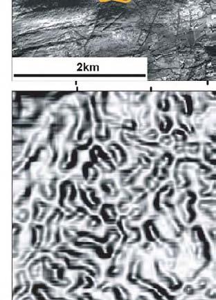
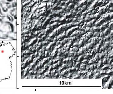
11 lineations identified in Ireland occupy a large size range, from the smallest identified drumlins at 131 metres in length (Figure 4a) to lineations which are more suitably interpreted as MSGLs, reaching lengths of over 10 km (Figure 4b). These longer lineations are found within landform patterns which have long been known (the north-westerly directed lineation pattern across Counties Roscommon and Mayo, towards the Ox Mountains and County Sligo coast; and the south-westwards pattern through the broad valley in County Clare constricted by the high terrain of the Burren to the west and the Slieve Aughtys to the east (see Close, 1867; Synge, 1970; McCabe, 1985; Warren, 1992)), these features have not previously been identified as MSGLs. This interpretation suggests these landform patterns are the legacy of faster flowing ice (Clark, 1993; Stokes and Clark, 1999; 2001). Overall, the range of observed morphologies of glacial lineations varies from classic elliptical drumlins to spindle shapes, barchan forms, curvilinear landforms, to quasi-circular forms which are less straightforward to classify (see other bedforms, below). The map clearly reveals the glacial lineations to dominate the lowlands, almost fully occupying the wide open plains and broad valleys which characterise the macro-topography of Ireland. A striking characteristic of the lineation distribution is the complex arrangement of individual features. Instances of lineation superimposition upon other bedforms, either ribbed moraine or other lineations, are found in abundance (Figure 5). Such arrangements suggest changing subglacial conditions for bedforming, frequently associated with a change in the requisite ice flow direction. The lineation record therefore contributes a relative chronology of palaeo-ice flow configuration. Interpretations of ice flow directions from lineation data, and their palaeo-ice sheet implications, will be addressed in forthcoming papers. 3.2 Ribbed moraine Ribbed moraine represent 20% of the number of features mapped. These ridge-like bedforms, which form transverse to the ice flow direction, were not widely recognised in the Irish landscape until the last 10 years or so (e.g. Knight and McCabe, 1997; McCabe et al., 1999; Clark and Meehan, 2001). The ribbed moraine population documented by our mapping confirms and extends the previously known distribution. The individuals within this population represent the largest forms of ribbed moraine identified hitherto in the world, and our mapping confirms their shape and scale and is consistent with the detailed morphometric analyses of Dunlop 341
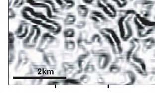
12 a Figure 4. Glacial lineations observed in Ireland range in size from (a) small drumlins (arrowed) of <500 m in length, to (b) MSGLs (mapped crestlines shown) several kilometres long (note the scale bar differences). Image in (a): SPOT, Slieve Aughty mountains; b): SRTM, NE visualisation with 4x vertical exaggeration, Counties Roscommon and Mayo. Projected on the Irish National Grid. and Clark (2006). The form and distribution of the Irish ribbed moraine appear to be largely unaffected by either geological or topographic variability, rather covering a large swath of the Irish midlands and occupying the core zone of the palaeo-ice sheet (Figure 6). At the other end of the scale, small transverse ridges were found in clusters across Counties Meath, Westmeath, Roscommon and Mayo (Figure 7). The size of these features is almost at the resolution limit of the available imagery and it is therefore likely that the mapped population of minor ridges is an under-representation of their true number and distribution. The interpretation of these minor transverse ridges clearly has implications for ice sheet reconstruction: subglacial or ice-marginal? Meehan (1999) first suggested the ridges in Co. Meath were push moraines and therefore ice-marginal. However, they were re-interpreted as ribbed moraine by Clark and Meehan (2001) on the basis of their relation to the underlying macro-topography: ridge disposition and distribution shows little sign of deflection by topography, suggesting ice was thick and ridges are subglacial, i.e. minor ribbed moraine. Following the same logic (Figure 7), two of the three major clusters of minor ridges are interpreted as subglacial in origin (Figure 7b and 7c) and are presented on the map. By contrast, the other cluster in north Co. Mayo (Figure 7d) feeds into a topographically confined bay; an ice-marginal context is plausible for the development of these ridges, b km
13 a b c d Figure 5. Superimposition and cross-cutting of landforms overwhelms the subglacial bedform record in Ireland. a) drumlins (SW-NE) cross-cut MSGLs (SE-NW) in Co. Mayo; SRTM image, NW illuminated, 4x vertical exaggeration. b) cross-cutting drumlins (left-right and top left - bottom right) in Co. Leitrim; Landsat ETM+, image rotated through 180 for better visualisation of landforms. c&d) drumlins superimposed perpendicularly on ribbed moraine; the ice flow direction revealed by the two landform types is the same. c: Landmap, NW illuminated, 4x vertical exaggeration; d: SRTM, NW illuminated, 4x vertical exaggeration. Projected on the Irish National Grid. 2km recording recession of an ice lobe through Killala Bay. This is consistent with previously interpreted retreat patterns for this area (e.g. Charlesworth, 1928; Synge and Stephens, 1960; Synge, 1969). Whereas larger ribbed moraine are frequently found to be overprinted by lineations, minor ribbed moraine display the reverse landform association, and are observed superimposed upon, or actively ribbing underlying glacial lineations. 343


, parts of")
 and")
.")


14 Figure 6. Large transverse ribbed moraine ridges occupy a vast swath of the Irish lowlands, and additionally overrun some areas of higher terrain such as Slieve Beagh (immediately NE of image centre), parts of the Cuilcagh mountains (west of centre) and Slieve Gullion (centre east). Cross-cutting between ribbed moraine groups, and the patterns of lineation superimposition indicate that the ribbed moraine population is the product of multiple phases of ice flow with different geometries. SRTM image, illuminated from the NW with 4x vertical exaggeration. Projected on the Irish National Grid. 344
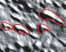
15 a b d c b High : 1020m c 2 km Low : 0m d Figure 7. Classification of minor ridges (a) into subglacial (b, c) or ice-marginal (d) or contexts on the basis of their relationship with the underlying macro-topography: a lack of deflection by the underlying gross topography suggests thick ice and a subglacial ridge origin; distribution restricted to low ground is more indicative of an ice-marginal context. Projected on the Irish National Grid. 2km 2km Other bedforms The mapping programme revealed a significant number of landforms which we interpret as bedforms, but which do not fit into the classical and clear-cut categories of lineations or ribbed moraine. These are usually quasi-circular in form, with diameters on the order of 500 metres (Figure 8), and were recorded as other since their genetic origin and palaeo-glaciological significance is less well known than for lineations or ribbed moraine. These bedforms are usually found within larger 345
16 assemblages of either drumlins, ribbed moraine or a mixed population, lending them an appearance of a hybrid bedform between the two end members. Such bedform morphologies have been previously observed in Ireland (e.g. Hill, 1973; Finch and Walsh, 1973; Dardis et al., 1984; McCabe, 1991; Smith and Clark, 2005); other authors have typically described as drumlins some of the features we record as quasi-circular. These enigmatic landforms have been little discussed regarding either their genetic (i.e. geomorphological process) or palaeo-glaciological significance km Figure 8. Quasi-circular drift landforms, interpreted as subglacial bedforms. Such landforms constitute 6% of the mapped subglacial bedform record and are frequently found in spatial association with drumlins or ribbed moraine. SPOT image from Bantry Bay, SW Ireland. Note this image is rotated through 180 to achieve a sun angle illuminating the image from the top. Projected on the Irish National Grid. 346
17 3.4 Map completeness and accuracy The imagery available to this research has been thoroughly examined through a number of repeat passes, and it is with confidence that the bedform dataset presented in the map is as complete a record of subglacial bedforms as revealed by this imagery. It is most unlikely that this is an entirely complete bedform record, i.e. truth. Submerged landforms would likely fill gaps in the spatial record of bedforms were they visible under the larger and deeper lakes: Lough Neagh, Lower Lough Erne, Lough Mask and Lough Corrib. The bedform record also extends to the present-day coastal zones and it is likely they pass offshore, where imagery was lacking at the time of mapping. We highlight the nearshore zone as a prime region for future mapping from bathymetric data. Data resolution (e.g. Landmap 25 m; Landsat ETM+ up to 15 m horizontal resolution) inevitably limits the number and accuracy of landforms mapped at the smaller end of the scale, although such under-representation within the mapped population is thought to be minimal. Bedform size is typically on the order of 100s s of metres, with relief up to 10s metres (Rose, 1987; Benn and Evans, 1998; Clark, 1993); indeed, the population of lineations identified here captures a range from ,522 m. Only the smallest and most subdued features should have escaped detection. It is anticipated that the mapping effort here has captured the range of shapes, scales, and most of the patterns of bedforms in Ireland. The new, emerging generation of even higher resolution data (i.e. sub 5 m) will likely yield higher populations of the smallest features. The accuracy of the mapping output is dependent upon the initial location accuracy of the source imagery. Minor geo-positional errors between data sources, and their deviation from true positioning (i.e. compared to OSi products) is estimated to be on the order of 100 m. 4. Implications and Conclusions Interestingly, whilst most Irish Ice Sheet models now depict offshore ice cover for the maximum period of glaciation (e.g. Warren, 1992; Bowen et al., 2002; Sejrup et al., 2005; Ó Cofaigh and Evans, 2007; McCabe, 2008), the overall bedform distribution is reminiscent of the restricted 347
18 glacial limits originally proposed by Synge (Synge and Stephens, 1960; Synge, 1970). However, it would be erroneous to return to this ice sheet interpretation on the basis of the subglacial bedform distribution. The absence of bedforms in southern-most Ireland is not necessarily indicative of the absence of ice, merely conditions in the subglacial environment which were not conducive to bedform generation, or, indeed, could indicate their subsequent removal or burial. The value of the subglacial bedform map of Ireland is twofold: the documented distribution and form of a large population of subglacial bedforms allows us to pursue a greater understanding of the geomorphological processes which produce subglacial bedforms; and it reveals elements of the geometry and behaviour of ice flow routes which generated the observed geomorphological record, thereby providing the basis for extracting palaeo-glaciological properties of the last Irish Ice Sheet. We have documented here the morphological and spatial properties of almost 33,000 bedforms. Such a large dataset is better able to examine and test theories of bedform genesis than smaller sample sizes from specific topographic, geologic or glaciological settings. Any bedforming theory must be able to account for the diversity of characteristics this record displays. This includes not only the classic drumlin and ribbed moraine properties, but the atypical shapes, sizes, arrangements, settings and degrees of reworking we have observed in the Irish record (e.g. Figure 9). Detailed geomorphological mapping and analysis of morphometric and spatial parameters (e.g. Clark et al., in press) enables quantitative bedforming models to be tested (e.g. Dunlop, 2004; Dunlop et al., in press) and will enable comparisons with potential controlling variables to be examined: topographic properties (shape, slope, elevation), bedrock and surface sediment lithologies, and glaciological properties (e.g. ice thickness). The overall coverage and majority of flow patterns revealed by the bedform record confirms and replicates what the existing literature reports and, in many places, adds considerable details of morphology, pattern, and the complexities of landform arrangements. The bedform record can therefore be interpreted in terms of what it reveals regarding ice flow directions, the necessary flow geometry and flow behaviour to explain the record, the ice sheet configuration and configuration changes, and should be integrated with other components of the glacial record for a full palaeo-glaciological reconstruction. The most significant new insight yielded by our mapping, and the most powerful indicator of the need for a new model of ice sheet history for Ireland, is the prevalence of bedform cross-cutting and 348
19 superimposition throughout the Irish landform record (Figure 10). The overwhelming dominance of cross-cutting bedform patterns has significant implications for the positions and movements of ice divides over Ireland. The bedform record demands an ice sheet model characterised by significant, and possibly repeated re-organisations of its geometry and structure. The map we present in this paper is the foundation for interpreting and reconstructing such a model of Irish Ice Sheet history. Software All imagery for geomorphological mapping was imported into, geocorrected and processed in ERDAS Imagine 8.7 software. Mapping was conducted in both ERDAS Imagine 8.7 and ESRI ArcMap 9.1, recording all mapped features in separate shapefiles according to landform type. The SRTM DEM (for terrestrial areas) and GEBCO DEM (bathymetry) used for the map background were processed in ArcMap, in which the final map production was undertaken. Figures within this paper were created in ArcMap and manipulated for aesthetic purposes in Adobe Illustrator 9. Acknowledgements The Geological Survey of Ireland, Environmental Protection Agency, Ordnance Survey Ireland and the OASIS programme for dissemination of SPOT imagery kindly provided data, on request, for free or at a considerably reduced cost. S.L.G. acknowledges a University of Sheffield studentship from Mike Smith, Jasper Knight and Tim Fisher are thanked for their reviews which have improved the clarity of the paper. Figure 9 (next page). The new Subglacial Bedform Map reveals a wide range of bedform shapes and sizes which provide a test of bedform genesis theories: any theory must be able to account for these morphologies. a) barchan-type drumlins intermingled with more classic types (County Monaghan), SRTM, NE illumination with 4x vertical exaggeration; b) crag and tails (County Westmeath), Landmap, NE illumination with 4x vertical exaggeration; c) quasi-circular bedforms (Bantry Bay, County Cork), SPOT; d) complex ridges with horns and drumlinised parts; we interpret this particular suite as a composite product of more than one ice flow (Clew Bay, County Mayo), SRTM, NW illumination with 4x vertical exaggeration; e) ribbed moraine with branching ridges displaying no coherent orientation (Omagh Basin, County Tyrone), SRTM, overhead (gradient) illumination with 4x vertical exaggeration; f) drumlinised mega-scale ribbed moraine (Counties Monaghan & Cavan), Landmap, NW illumination with 4x vertical exaggeration. Projected on the Irish National Grid. 349


20 Journal of Maps, 2008, km Figure 9. Caption on previous page. 350
21 Journal of Maps, 2008, Figure 10. Cross-cutting and superimposed bedform patterns are widespread throughout the bedform record of Ireland. On a 2 x 2 km grid, black cells show the distribution of bedforms; green cells indicate where superimposition or cross-cutting of bedforms occurs. There is not a simple snapshot pattern of ice flow in Ireland but, rather, the prevalence of superimposition and cross-cutting relationships demands an ice sheet model characterised by frequent changes of flow configuration to repeatedly rework the bed in changing directions. 351
22 References BALLANTYNE, C. K., STONE, J. O. and MCCARROLL, D. (2008) Dimensions and chronology of the last ice sheet in Western Ireland, Quaternary Science Reviews, 27, 304, BENN, D. I. and EVANS, D. J. A. (1998) Glaciers and Glaciation, Arnold, London. BOULTON, G. S. and CLARK, C. D. (1990a) A highly mobile Laurentide ice sheet revealed by satellite images of glacial lineations, Nature, 346, BOULTON, G. S. and CLARK, C. D. (1990b) The Laurentide ice sheet through the last glacial cycle: the topology of drift lineations as a key to the dynamic behaviour of former ice sheets, Transactions of the Royal Society of Edinburgh: Earth Sciences, 81, BOWEN, D. Q., PHILLIPS, F. M., MCCABE, A. M., KNUTZ, P. C. and SYKES, G. A. (2002) New data for the Last Glacial Maximum in Great Britain and Ireland, Quaternary Science Reviews, 21, BROOKS, A. J., BRADLEY, S. L., EDWARDS, R. J., MILNE, G. A., HORTON, B. and SHENNAN, I. (2008) Postglacial relative sea-level observations from Ireland and their role in glacial rebound modelling, Journal of Quaternary Science, 23, 2, CHARLESWORTH, J. K. (1928) The glacial geology of North Mayo and West Sligo, Proceedings of the Royal Irish Academy, 38, CLARK, C. D. (1993) Mega-scale glacial lineations and cross cutting ice-flow landforms, Earth Surface Processes and Landforms, 18, CLARK, C. D. (1997) Reconstructing the evolutionary dynamics of palaeo-ice sheets using multi-temporal evidence, remote sensing and GIS, Quaternary Science Reviews, 16, 9, CLARK, C. D., HUGHES, A. L. C., GREENWOOD, S. L., SPAGNOLO, M. and NG, F. S. L. (in press) Size and shape characteristics of drumlins, derived from a large sample, and associated scaling laws, Quaternary Science Reviews. 352
23 CLARK, C. D. and MEEHAN, R. T. (2001) Subglacial bedform geomorphology of the Irish Ice Sheet reveals major configuration changes during growth and decay, Journal of Quaternary Science, 16, CLOSE, M. H. (1867) Notes on the general glaciation of Ireland, Journal of the Royal Geological Society of Ireland, 1, DARDIS, G. F., MCCABE, A. M. and MITCHELL, W. I. (1984) Characteristics and origins of lee-side stratification sequences in Late Pleistocene drumlins, Northern Ireland, Earth Surface Processes and Landforms, 9, DUNLOP, P. (2004) The characteristics of ribbed moraine and assessment of theories for their genesis, Ph.D. thesis, Department of Geography, University of Sheffield. DUNLOP, P. and CLARK, C. D. (2006) The morphological characteristics of ribbed moraine, Quaternary Science Reviews, 25, 13-14, DUNLOP, P., CLARK, C. D. and HINDMARSH, R. C. A. (in press) The Bed Ribbing Instability Explanation (BRIE) testing a numerical model of ribbed moraine formation arising from coupled flow of ice and subglacial sediment, Journal of Geophysical Research - Earth Surface. DYKE, A. S. and PREST, V. K. (1987) Late Wisconsinan and Holocene history of the Laurentide Ice Sheet, Geographie Physique et Quaternaire, 41, EYLES, N. and MCCABE, A. M. (1989) The late Devensian (< BP) Irish Sea Basin: The sedimentary record of a collapsed ice sheet margin, Quaternary Science Reviews, 8, FARRELL, A., MCCARRON, S. and COXON, P. (2005) The Quaternary Geology of Central Western Ireland, In Coxon, P., (ed.) The Quaternary of Central Western Ireland: Field Guide, Quaternary Research Association; London, pp FARRINGTON, A. (1936) The glaciation of the Bantry Bay district, Scientific Proceedings of the Royal Dublin Society, 21, FINCH, T. F. and WALSH, M. (1973) Drumlins of County Clare, Proceedings of the Royal Irish Academy, 73B,
24 GREENWOOD, S. L. (2008) A palaeo-glaciological reconstruction of the last Irish Ice Sheet, Ph.D. thesis, Department of Geography, University of Sheffield. HEGARTY, S. (2002) Pathways and processes of Late Pleistocene subglacial meltwater flows, County Kilkenny, Ph.D. thesis, Department of Geography, University College, Dublin. HILL, A. R. (1973) The distribution of drumlins in County Down, Ireland, Annals of the Association of American Geographers, 63, 2, HULL, E. (1878) Physical Geology and Geography of Ireland, Edward Stanford, London. JANSSON, K. N. and GLASSER, N. F. (2005) Using Landsat 7 ETM+ imagery and Digital Terrain Models for mapping glacial lineaments on former ice sheet beds, International Journal of Remote Sensing, 26, 18, KINAHAN, G. H. and CLOSE, M. H. (1872) The General Glaciation of Iar-Connaught and its neighbourhood, in the Counties of Galway and Mayo, Hodges and Foster, Dublin. KLEMAN, J. and BORGSTRÖM, I. (1996) Reconstruction of palaeo-ice sheets: the use of geomorphological data, Earth Surface Processes and Landforms, 21, KLEMAN, J., HÄTTESTRAND, C., BORGSTRÖM, I. and STROEVEN, A. (1997) Fennoscandian Palaeoglaciology Reconstructed Using A Glacial Geological Inversion Model, Journal of Glaciology, 43, KLEMAN, J., HÄTTESTRAND, C., STROEVEN, A. P., JANSSON, K. N., DE ANGELIS, H. and BORGSTRÖM, I. (2006) Reconstruction of paleo-ice sheets - inversion of their geomorphological record, In Knight, P. G., (ed.) Glacier Science and Environmental Change, Blackwell, Oxford, pp KNIGHT, J. (2001) Glaciomarine deposition around the Irish Sea basin: some problems and solutions, Journal of Quaternary Science, 16, 5, KNIGHT, J. (2003) Geomorphic evidence for patterns of late Midlandian ice advance and retreat in the Omagh Basin, Irish Geography, 36, 1,
25 KNIGHT, J., COXON, P., MCCABE, A. M. and MCCARRON, S. G. (2004) Pleistocene glaciations in Ireland, In Ehlers, J. and Gibbard, P. L., (eds.) Quaternary Glaciations - extent and chronology. Part 1: Europe, Elsevier, Amsterdam, pp KNIGHT, J. and MCCABE, A. M. (1997) Identification and significance of ice-flow-transverse subglacial ridges (Rogen moraines) in north central Ireland, Journal of Quaternary Science, 12, 6, LAMBECK, K. (1996) Glaciation and sea-level change for Ireland and the Irish Sea since Late Devensian/Midlandian time, Journal of the Geological Society of London, 153, MCCABE, A. M. (1985) Glacial Geomorphology, In Edwards, K. J. and Warren, W. P., (eds.) The Quaternary History of Ireland, Academic Press, London, pp MCCABE, A. M. (1987) Quaternary Deposits and Glacial Stratigraphy in Ireland, Quaternary Science Reviews, 6, MCCABE, A. M. (1991) The distribution and stratigraphy of drumlins in Ireland, In Ehlers, J., Gibbard, P. L. and Rose, J., (eds.) Glacial Deposits in Great Britain and Ireland, Balkema, Rotterdam, pp MCCABE, A. M. (1997) Geological constraints on geophysical models of relative sea-level change during deglaciation of the western Irish Sea Basin, Journal of the Geological Society of London, 154, 4, MCCABE, A. M. (2008) Glacial Geology and Geomorphology: The Landscapes of Ireland, Dunedin Academic Press, Edinburgh. MCCABE, A. M., DARDIS, G. F. and HANVEY, P. M. (1984) Sedimentology of a Late Pleistocene submarine moraine complex, County Down, Northern Ireland, Journal of Sedimentary Research, 54, MCCABE, A. M., KNIGHT, J. and MCCARRON, S. G. (1998) Evidence for Heinrich event 1 in the British Isles, Journal of Quaternary Science, 13, 6, MCCABE, A. M., KNIGHT, J. and MCCARRON, S. G. (1999) Ice-flow stages and glacial bedforms in north central Ireland: a record of rapid environmental change during the last glacial termination, Journal of the Geological Society of London, 156,
26 MCCARROLL, D. (2001) Deglaciation of the Irish Sea Basin: a critique of the glaciomarine hypothesis, Journal of Quaternary Science, 16, 5, MEEHAN, R. T. (1999) Directions of ice flow during the last glaciation in counties Meath, Westmeath and Cavan, Irish Geography, 32, 1, MEEHAN, R. T. (2004) Evidence for several ice marginal positions in east central Ireland, and their relationship to the Drumlin Readvance Theory, In Ehlers, J. and Gibbard, P. L., (eds.) Quaternary Glaciations - extent and chronology. Part 1: Europe, Elsevier, Amsterdam, pp MEEHAN, R. T. (2006) Glacial readvances: self-promulgating theories or science-based reality?, In Knight, P. G., (ed.) Glacier Science and Environmental Change, Blackwell, Oxford, pp MENZIES, J. (1987) Towards a general hypothesis on the formation of drumlins, In Menzies, J. and Rose, J., (eds.) Drumlin Symposium, Balkema; Rotterdam, pp Ó COFAIGH, C. and EVANS, D. J. A. (2001a) Deforming bed conditions associated with a major ice stream of the last British ice sheet, Geology, 29, 9, Ó COFAIGH, C. and EVANS, D. J. A. (2001b) Sedimentary evidence for deforming bed conditions associated with a grounded Irish Sea glacier, southern Ireland, Journal of Quaternary Science, 16, 5, Ó COFAIGH, C. and EVANS, D. J. A. (2007) Radiocarbon constraints on the age of the maximum advance of the British-Irish Ice Sheet in the Celtic Sea, Quaternary Science Reviews, 26, 9-10, ROSE, J. (1987) Drumlins as part of a glacier bedform continuum, In Menzies, J. and Rose, J., (eds.) Drumlin Symposium, Balkema; Rotterdam, pp SEJRUP, H. P., HJELSTUEN, B. O., TORBJORN DAHLGREN, K. I., HAFLIDASON, H., KUIJPERS, A., NYGÅRD, A., PRAEG, D., STOKER, M. S. and VORREN, T. O. (2005) Pleistocene glacial history of the NW European continental margin, Marine and Petroleum Geology, 22, 9-10,
27 SMITH, M. J. and CLARK, C. D. (2005) Methods for the visualisation of digital elevation models for landform mapping, Earth Surface Processes and Landforms, 30, SMITH, M. J. and WISE, S. M. (2007) Problems of bias in mapping linear landforms from satellite imagery, Journal of Applied Earth Observation and Geoinformation, 9, STOKES, C. R. and CLARK, C. D. (1999) Geomorphological criteria for identifying Pleistocene ice streams, Annals of Glaciology, 28, STOKES, C. R. and CLARK, C. D. (2001) Palaeo-ice streams, Quaternary Science Reviews, 20, 13, SYNGE, F. and STEPHENS, N. (1960) The Quaternary Period in Ireland - an assessment, Irish Geography, 4, SYNGE, F. M. (1950) The glacial deposits around Trim, county Meath, Proceedings of the Royal Irish Academy, 53, SYNGE, F. M. (1969) The Würm ice limit in the West of Ireland, In Wright, H. E., (ed.) Quaternary Geology and Climate, National Academy of Sciences; Washington DC, pp SYNGE, F. M. (1970) The Irish Quaternary: Current views 1969, In Stephens, N. and Glasscock, R. E., (eds.) Irish Geographical Studies, in honour of E. Estyn Evans, The Queen s University of Belfast, Belfast, pp SYNGE, F. M. (1979) Glacial landforms, In Haughton, J. P., (ed.) Atlas of Ireland, Royal Irish Academy, Dublin, p. 21. THOMAS, G. S. P. and SUMMERS, A. J. (1983) The Quaternary stratigraphy between Blackwater Harbour and Tinnaberna, County Wexford, Journal of Earth Sciences, Royal Dublin Society, 5, WARREN, W. P. (1988) The Pleistocene Geology and Geomorphology of Glen Behy, Co. Kerry, Irish Geography, 21, WARREN, W. P. (1991) Fenitian (Midlandian) glacial deposits and glaciation in Ireland and the adjacent offshore regions, In Ehlers, J., Gibbard, P. L. and Rose, J., (eds.) Glacial Deposits in Great Britain and Ireland, Balkema, Rotterdam, pp WARREN, W. P. (1992) Drumlin orientation and the pattern of glaciation in Ireland, Sveriges Geologiska Undersökning, 81,
Site 4.7. Thornhill Drumlin Jane K. Hart
 Site 4.7. Thornhill Drumlin Jane K. Hart Introduction The drumlins in the West of Ireland represent some of the best exposured features in the whole of Britain and Ireland, and have been studied by numerous
Deglacial landform assemblage records fast ice-flow and retreat, Inner Hebrides, Scotland
 Deglacial landform assemblage records fast ice-flow and retreat, Inner Hebrides, Scotland D. DOVE 1*, A. FINLAYSON 1, T., BRADWELL 1,2, J. A. HOWE 3 & R. AROSIO 3 1 British Geological Survey, Murchison
Introduction to the Special Issue on Glacial Geology and Geomorphology
 Journal of Maps, 2006, i-v Introduction to the Special Issue on Glacial Geology and Geomorphology CHRIS D. CLARK Department of Geography, University of Sheffield, Sheffield, S10 2TN, UK; c.clark@sheffield.ac.uk
Industrialised Peat Extraction Scoping Project. Technical Report & Results. from. University College Cork. November 2010
 Industrialised Peat Extraction Scoping Project Cataloguing of exposed peat soil areas identified on Peatlands of Ireland Mapped from Landsat Imagery (PIMLI) Technical Report & Results from University College
COASTAL QUATERNARY GEOLOGY MAPPING FOR NSW: EXAMPLES AND APPLICATIONS
 COASTAL QUATERNARY GEOLOGY MAPPING FOR NSW: EXAMPLES AND APPLICATIONS A Troedson Geological Survey of New South Wales Abstract Detailed geological mapping of the coastal plains of regional NSW was undertaken
Glacial processes and landforms NGEA01, 2014
 Glacial processes and landforms NGEA01, 2014 Cecilia Akselsson Department of Physical Geography and Ecosystem Science Lund University Geomorphological processes and landforms all over the world Periglacial
Reconstruction of the Vistula ice stream lobe during LGM: preliminary results of the research project
 Ice, water, humans Quaternary landscape evolution in the Peribaltic Region 35th Annual conference of the German Quaternary Association DEUQUA e.v. 12th Annual Conference of the INQUA PeriBaltic WG 13th-17th
Lake Levels and Climate Change in Maine and Eastern North America during the last 12,000 years
 Maine Geologic Facts and Localities December, 2000 Lake Levels and Climate Change in Maine and Eastern North America during the last 12,000 years Text by Robert A. Johnston, Department of Agriculture,
PROANA A USEFUL SOFTWARE FOR TERRAIN ANALYSIS AND GEOENVIRONMENTAL APPLICATIONS STUDY CASE ON THE GEODYNAMIC EVOLUTION OF ARGOLIS PENINSULA, GREECE.
 PROANA A USEFUL SOFTWARE FOR TERRAIN ANALYSIS AND GEOENVIRONMENTAL APPLICATIONS STUDY CASE ON THE GEODYNAMIC EVOLUTION OF ARGOLIS PENINSULA, GREECE. Spyridoula Vassilopoulou * Institute of Cartography
Prentice Hall EARTH SCIENCE
 Prentice Hall EARTH SCIENCE Tarbuck Lutgens Chapter 7 Glaciers, Desert, and Wind 7.1 Glaciers Types of Glaciers A glacier is a thick ice mass that forms above the snowline over hundreds or thousands of
EMERGENCY PLANNING IN NORTHERN ALGERIA BASED ON REMOTE SENSING DATA IN RESPECT TO TSUNAMI HAZARD PREPAREDNESS
 EMERGENCY PLANNING IN NORTHERN ALGERIA BASED ON REMOTE SENSING DATA IN RESPECT TO TSUNAMI HAZARD PREPAREDNESS Barbara Theilen-Willige Technical University of Berlin, Institute of Applied Geosciences Department
Supporting evidence from the New York drumlin field that elongate subglacial bedforms indicate fast ice flow
 Supporting evidence from the New York drumlin field that elongate subglacial bedforms indicate fast ice flow JASON P. BRINER BOREAS Briner, J. P. 2007 (April): Supporting evidence from the New York drumlin
Global Survey of Organized Landforms: Recognizing Linear Sand Dunes
 Global Survey of Organized Landforms: Recognizing Linear Sand Dunes P. L. Guth 1 1 Department of Oceanography, US Naval Academy 572C Holloway Rd, Annapolis MD 21402 USA Telephone: 00-1-410-293-6560 Fax:
Page 1. Name:
 Name: 1) Which property would best distinguish sediment deposited by a river from sediment deposited by a glacier? thickness of sediment layers age of fossils found in the sediment mineral composition
Glaciers. (Shaping Earth s Surface, Part 6) Science 330 Summer 2005
 Science 330 Summer 2005") Glaciers (Shaping Earth s Surface, Part 6) Science 330 Summer 2005 1 Glaciers Glaciers are parts of two basic cycles Hydrologic cycle Rock cycle Glacier a thick mass of ice that originates on land from
Glaciers (Shaping Earth s Surface, Part 6) Science 330 Summer 2005 1 Glaciers Glaciers are parts of two basic cycles Hydrologic cycle Rock cycle Glacier a thick mass of ice that originates on land from
Glacial Modification of Terrain
 Glacial Modification Part I Stupendous glaciers and crystal snowflakes -- every form of animate or inanimate existence leaves its impress upon the soul of man. 1 -Orison Swett Marden Glacial Modification
DIGITAL ELEVATION MODELS FROM SHUTTLE RADAR TOPOGRAPHY MISSION DATA NEW INSIGHTS INTO THE QUATERNARY HISTORY OF NEWFOUNDLAND
 Current Research (2006) Newfoundland and Labrador Department of Natural Resources Geological Survey, Report 06-1, pages 177-189 DIGITAL ELEVATION MODELS FROM SHUTTLE RADAR TOPOGRAPHY MISSION DATA NEW INSIGHTS
Investigating Glacial Landscape Systems 3 days
 AS Level Geography OCR Investigating Glacial Landscape Systems 3 days Deliver two full days of fieldwork within an inspiring physical environment. Prepare AS level students for the Paper 1: Landscape and
Maximum Extent of Pleistocene Glaciation - 1/3 of land surface Most recent glacial maximum peaked 18,000 years ago and is considered to have ended
 Glaciers Maximum Extent of Pleistocene Glaciation - 1/3 of land surface Most recent glacial maximum peaked 18,000 years ago and is considered to have ended 10,000 B.P. Current Extent of Glaciation - about
Landform modification by palaeo-ice streams in east-central Ireland
 Annals of Glaciology 28 1999 # International Glaciological Society Landform modification by palaeo-ice streams in east-central Ireland Jasper Knight, Stephen G. McCarron, A. Marshall McCabe School of Environmental
Geology and New England Landscapes
 Geology and New England Landscapes Jim Turenne, CPSS USDA-NRCS Warwick, RI. http://nesoil.com Why Geology? Provides the big picture of site conditions. Major part of soil formation (parent material and
PHYSICAL GEOGRAPHY. By Brett Lucas
 PHYSICAL GEOGRAPHY By Brett Lucas GLACIAL PROCESSES Glacial Processes The Impact of Glaciers on the Landscape Glaciations Past and Present Types of Glaciers Glacier Formation and Movement The Effects of
Lowland Glaciation North Wales
 Lowland Glaciation North Wales Background Although there have been many glaciations and advances in ice, the most significant for this are was the Dimlington Stadial which was a period of glacial advance
Supplementary Fig. 1. Locations of thinning transects and photos of example samples. Mt Suess/Gondola Ridge transects extended metres above
 Supplementary Fig. 1. Locations of thinning transects and photos of example samples. Mt Suess/Gondola Ridge transects extended 260 24 metres above the modern surface of Mackay Glacier, and included 16
Glaciers Earth 9th Edition Chapter 18 Glaciers: summary in haiku form Key Concepts Glaciers Glaciers Glaciers Glaciers
 1 2 3 4 5 6 7 8 9 10 11 12 13 14 Earth 9 th Edition Chapter 18 : summary in haiku form Ten thousand years thence big glaciers began to melt - called "global warming." Key Concepts and types of glaciers.
Glacial and glacially-related features on the continental margin of northwest Ireland mapped from marine geophysical data
 Glacial and glacially-related features on the continental margin of northwest Ireland mapped from marine geophysical data SARA BENETTI 1, PAUL DUNLOP 1 and COLM Ó COFAIGH 2 1 School of Environmental Sciences,
Geological record of Ice Stream Collapse, Pine Island Bay, West Antarctica
 GSA DATA REPOSITORY 2011212 Jakobsson et al. Geological record of Ice Stream Collapse, Pine Island Bay, West Antarctica Figure DR1. The corrugated furrows in central Pine Island Bay Trough and the iceberg
THE DIGITAL TERRAIN MAP LIBRARY: AN EXPLORATIONIST S RESOURCE
 THE DIGITAL TERRAIN MAP LIBRARY: AN EXPLORATIONIST S RESOURCE By I.C.L. Webster, P.J. Desjardins and W.E. Kilby KEYWORDS: digital terrain maps, digital terrain stability maps, surficial geology, GIS, raster
Lecture Outlines PowerPoint. Chapter 6 Earth Science 11e Tarbuck/Lutgens
 Lecture Outlines PowerPoint Chapter 6 Earth Science 11e Tarbuck/Lutgens 2006 Pearson Prentice Hall This work is protected by United States copyright laws and is provided solely for the use of instructors
JENKINS, GERAINT,THOMAS-HOWARD. a full bibliographic reference is made to the original source
 Durham E-Theses The Lateglacial history of Bassenthwaite Lake and adjacent areas, Lake District, UK; a sub-bottom proling and geomorphological investigation JENKINS, GERAINT,THOMAS-HOWARD How to cite:
What is a Glacier? Types of Glaciers
 Alpine & Continental Glaciers Glacial Mass Balance Glacial Ice Formation Glacial Movement & Erosion Erosional and Depositional Landforms The Pleistocene Epoch Geomorphology of SW Manitoba Chapter 17 1
Ice Sheets and Late Quaternary Environmental Change
 Ice Sheets and Late Quaternary Environmental Change Martin J. Siegert Bristol Glaciology Centre, School of Geographical Sciences University of Bristol JOHN WILEY & SONS, LTD Chichester New York Weinheim
Name: Mid-Year Review #2 SAR
 Name: Mid-Year Review #2 SAR Base your answers to questions 1 through 3 on on the diagram below, which shows laboratory materials used for an investigation of the effects of sediment size on permeability,
A glacial geomorphological map of the Seno Skyring-Seno. Otway-Strait of Magellan region, southernmost Patagonia
 A glacial geomorphological map of the Seno Skyring-Seno Otway-Strait of Magellan region, southernmost Patagonia HAROLD LOVELL*, CHRIS R. STOKES and MICHAEL J. BENTLEY Department of Geography, Durham University,
Which landscape best represents the shape of the valleys occupied by glaciers? A) B) C) D)
 B) C) D)") 1. Glaciers often form parallel scratches and grooves in bedrock because glaciers A) deposit sediment in unsorted piles B) deposit rounded sand in V-shaped valleys C) continually melt and refreeze D) drag
1. Glaciers often form parallel scratches and grooves in bedrock because glaciers A) deposit sediment in unsorted piles B) deposit rounded sand in V-shaped valleys C) continually melt and refreeze D) drag
T. Perron Glaciers 1. Glaciers
 T. Perron 12.001 Glaciers 1 Glaciers I. Why study glaciers? [PPT: Perito Moreno glacier, Argentina] Role in freshwater budget o Fraction of earth s water that is fresh (non-saline): 3% o Fraction of earth
Existence of Geomorphological Entity of the Description of the Southern Irish End Moraine
 Existence of Geomorphological Entity of Description of Sourn Irish End Moraine Introduction The south-east of Ireland has been largely ignored up until very recent times by Quaternary researchers in Ireland.
,Baynes Lake. TO...?&.?...A 2...KO.?'!!&... Sr. *logical Engineer
 > i evernment OF BRITISH COLUMBIA a TO...?&.?...A 2....KO.?'!!&... Sr. *logical Engineer... Grou,,water. Section Hydrology Division Wat.er... In~.~s.tiga.ti.On.s..Branck.... 5 u BJECT...C;.roun.dw.ater...Snve
Ice-stream stability on a reverse bed slope
 SUPPLEMENTARY INFORMATION DOI: 10.1038/NGEO1600 Supplementary Information: Ice stream stability on a reverse bed Ice-stream stability on a reverse bed slope slope Stewart S.R. Jamieson 1, Andreas Vieli
Landscape. Review Note Cards
 Landscape Review Note Cards Last Ice Age Pleistocene Epoch that occurred about 22,000 Years ago Glacier A large, long lasting mass of ice which forms on land and moves downhill because of gravity. Continental
Developing a Seabed Resurvey Strategy: A GIS approach to modelling seabed changes and resurvey risk
 Developing a Seabed Resurvey Strategy: A GIS approach to modelling seabed changes and resurvey risk A. M. Bakare, J. G. Morley, R. R. Simons Department of Geomatic Engineering, University College London,
Ice-flow stages and glacial bedforms in north central Ireland: a record of rapid environmental change during the last glacial termination
 Journal of the Geological Society, London, Vol. 156, 1999, pp. 63 72. Printed in Great Britain. Ice-flow stages and glacial bedforms in north central Ireland: a record of rapid environmental change during
1. Any process that causes rock to crack or break into pieces is called physical weathering. Initial product = final product
 Weathering 1. Any process that causes rock to crack or break into pieces is called physical weathering. Initial product = final product End Result of physical weathering is increased surface area. 2. Physical
GEOL.3250 Geology for Engineers Glacial Geology
 GEOL.3250 Geology for Engineers Glacial Geology NAME Part I: Continental Glaciation Continental glaciers are large ice sheets that cover substantial portions of the land area. In the region of accumulation
EXTERNAL LAND FORMING PROCESSES
 NAME SCHOOL INDEX NUMBER DATE EXTERNAL LAND FORMING PROCESSES WEATHERING 1 1998 Q 7 (a) (i) What is the difference between weathering and mass wasting (ii) List five processes involved in chemical weathering
Clast fabric in a Stony Brook campus moraine: Testing models for the process of glacial lobe dynamics
 Clast fabric in a Stony Brook campus moraine: Testing models for the process of glacial lobe dynamics Jennifer DePaoli, Charles Regulinski, Josh Timlin, Dan Davis and Elliot Klein Department of Geosciences
GLY Coastal Geomorphology Notes
 GLY 4734 - Coastal Geomorphology Notes Dr. Peter N. Adams Spring 2011 2 Coastal Classification In this lecture, we discuss some successful classification schemes of the coastal landscape, and pay particular
Neogene Uplift of The Barents Sea
 Neogene Uplift of The Barents Sea W. Fjeldskaar A. Amantov Tectonor/UiS, Stavanger, Norway FORCE seminar April 4, 2013 The project (2010-2012) Funding companies Flat Objective The objective of the work
Chapter 5: Glaciers and Deserts
 I. Glaciers and Glaciation Chapter 5: Glaciers and Deserts A. A thick mass of ice that forms over land from the compaction and recrystallization of snow and shows evidence of past or present flow B. Types
Evidence of Ice Retreat, East Shore of Sabattus Pond
 Maine Geologic Facts and Localities November, 2002 Evidence of Ice Retreat, East Shore of Sabattus Pond 44 7 25.14 N, 70 5 21.69 W Text by Michael E. Foley, Department of Agriculture, Conservation & Forestry
QUATERNARY AND GLACIAL GEOLOGY
 QUATERNARY AND GLACIAL GEOLOGY JURGEN EHLERS Geologisches Landesamt, Germany Translated from Allgemeine und historische Quartdrgeologie English version by Philip L. Gibbard JOHN WILEY & SONS Chichester
OZ SEEBASE TM. Datasets. Digital Elevation Model
 Digital Elevation Model 10 Digital Elevation Models (DEM s) often show the youngest structures, and any active geological structures. They are widely used for neotectonic analysis. The composition of eroding
Digital Elevation Models (DEM) / DTM
 / DTM") Digital Elevation Models (DEM) / DTM Uses in remote sensing: queries and analysis, 3D visualisation, classification input Fogo Island, Cape Verde Republic ASTER DEM / image Banks Peninsula, Christchurch,
Digital Elevation Models (DEM) / DTM Uses in remote sensing: queries and analysis, 3D visualisation, classification input Fogo Island, Cape Verde Republic ASTER DEM / image Banks Peninsula, Christchurch,
High-resolution Geophysical Mapping of Submarine Glacial Landforms
 High-resolution Geophysical Mapping of Submarine Glacial Landforms M. Jakobsson 1, J.A. Dowdeswell 2, M. Canals 3, B.J. Todd 4, E.K. Dowdeswell 2, K.A. Hogan 5 L.A. Mayer 6 1 Stockholm University, Sweden
Hugo Dubé-Loubert, Virginie Daubois, Guillaume Allard (MERN) and Martin Roy (UQAM) PRO
 and Martin Roy (UQAM) PRO") BY QUATERNARY SURVEYS,, (MERN) and Martin Roy (UQAM) PRO 2015-04 Exploration targets identified by surveys in the southeastern part of the Province,, (MERN) and Martin Roy (UQAM) PRO 2015-04 Introduction
BY QUATERNARY SURVEYS,, (MERN) and Martin Roy (UQAM) PRO 2015-04 Exploration targets identified by surveys in the southeastern part of the Province,, (MERN) and Martin Roy (UQAM) PRO 2015-04 Introduction
BLAKENEY ESKER AND HOW IT FORMED. The Blakeney Esker is a ridge, around 3.5 km in length, which runs southeastwards
 BLAKENEY ESKER AND HOW IT FORMED Introduction The Blakeney Esker is a ridge, around 3.5 km in length, which runs southeastwards from west of Blakeney, to Wiveton Downs, north-west of Glandford, in north
Digital Elevation Models (DEM) / DTM
 / DTM") Digital Elevation Models (DEM) / DTM Uses in remote sensing: queries and analysis, 3D visualisation, layers in classification Fogo Island, Cape Verde Republic ASTER DEM / image Banks Peninsula, Christchurch,
Digital Elevation Models (DEM) / DTM Uses in remote sensing: queries and analysis, 3D visualisation, layers in classification Fogo Island, Cape Verde Republic ASTER DEM / image Banks Peninsula, Christchurch,
TEMPORAL VARIABILITY OF ICE FLOW ON HOFSJÖKULL, ICELAND, OBSERVED BY ERS SAR INTERFEROMETRY
 TEMPORAL VARIABILITY OF ICE FLOW ON HOFSJÖKULL, ICELAND, OBSERVED BY ERS SAR INTERFEROMETRY Florian Müller (1), Helmut Rott (2) (1) ENVEO IT, Environmental Earth Observation GmbH, Technikerstrasse 21a,
Guided Notes Surface Processes. Erosion & Deposition By: Glaciers
 Guided Notes Surface Processes Erosion & Deposition By: Glaciers K. Coder 2015 26) How does moving ice erode and deposit sediments? Glaciers (Movement of Ice): a naturally formed mass of ice and snow that
Michigan s Geology and Groundwater
 Michigan s Geology and Groundwater Ralph J. Haefner Deputy Director U.S. Geological Survey Michigan-Ohio Water Science Center Lansing, Michigan Outline About the USGS Geology 101 Michigan s geology Bedrock
Reprint of article that appeared in Hydro INTERNATIONAL November 2006 Volume 10 Issue 9
 Reprint of article that appeared in Hydro INTERNATIONAL November 2006 Volume 10 Issue 9 While Google Earth is the best known 3D web-mapping viewer currently in the public domain, there are alternative
AER/AGS Open File Report An Update to the Glacial Landforms Map of Alberta
 AER/AGS Open File Report 2018-08 An Update to the Glacial Landforms Map of Alberta AER/AGS Open File Report 2018-08 An Update to the Glacial Landforms Map of Alberta N. Atkinson, D.J. Utting and S.M. Pawley
Marine geophysical evidence for Late Pleistocene ice sheet extent and recession off north-west Ireland
 1 2 3 4 5 6 7 8 9 Marine geophysical evidence for Late Pleistocene ice sheet extent and recession off north-west Ireland Colm Ó Cofaigh 1*, Paul Dunlop 2 and Sara Benetti 2 1 Department of Geography, Durham
Glaciers form wherever snow and ice can accumulate High latitudes High mountains at low latitudes Ice temperatures vary among glaciers Warm
 The Cryosphere Glaciers form wherever snow and ice can accumulate High latitudes High mountains at low latitudes Ice temperatures vary among glaciers Warm (temperate) glaciers: at pressure melting point,
The syllabus was approved by Study programmes board, Faculty of Science on to be valid from , autumn semester 2016.
 Faculty of Science GEON05, Quaternary Geology: Glacial Sedimentology - Processes, Sediments and Landform Systems, 15 credits Kvartärgeologi: Glacial sedimentologi - processer, sediment och landformssystem,
Topic 2: Landscape Systems, Processes and Change
 Topic 2: Landscape Systems, Processes and Change Option 2A: Glaciated Landscapes and Change Overview Ice sheets and glaciers operate within a landscape system as glacial processes of erosion, transport
Outcrop suitability analysis of blueschists within the Dry Lakes region of the Condrey Mountain Window, North-central Klamaths, Northern California
 Outcrop suitability analysis of blueschists within the Dry Lakes region of the Condrey Mountain Window, North-central Klamaths, Northern California (1) Introduction: This project proposes to assess the
Chapter 2. Wearing Down Landforms: Rivers and Ice. Physical Weathering
 Chapter 2 Wearing Down Landforms: Rivers and Ice Physical Weathering Weathering vs. Erosion Weathering is the breakdown of rock and minerals. Erosion is a two fold process that starts with 1) breakdown
CARD #1 The Shape of the Land: Effects of Crustal Tilting
 CARD #1 The Shape of the Land: Effects of Crustal Tilting When we look at a birds-eye view of the Great Lakes, it is easy to assume the lakes are all at a similar elevation, but viewed in this way, we
Lecture Outline Lecture Outline Monday April 9-16, 2018 Questions? Announcements:
 Lecture Outline Lecture Outline Monday April 9-16, 2018 Questions? Announcements: Geology 101 Night Video: The Day After Tomorrow Hollywood disaster movie about the onset of a glacial period When: Monday
Bell Ringer. Are soil and dirt the same material? In your explanation be sure to talk about plants.
 Bell Ringer Are soil and dirt the same material? In your explanation be sure to talk about plants. 5.3 Mass Movements Triggers of Mass Movements The transfer of rock and soil downslope due to gravity is
Edinburgh Research Explorer
 Edinburgh Research Explorer GEOMORPHOLOGY Rivers split as mountains grow Citation for published version: Attal, M 2009, 'GEOMORPHOLOGY Rivers split as mountains grow' Nature Geoscience, vol. 2, no. 11,
Areal Scour vs. Selective Linear Erosion
 Erosional Forms and Landscapes Erosional Landscapes Areal Scour vs. Selective Linear Erosion Cirques Form and Morphology Many Forms Red Tarn Cirque Basin English Lake District Red Tarn Cirque Basin, English
Moosehead Lake and the Tale of Two Rivers
 Maine Geologic Facts and Localities June, 2005 45 o 53 5.09 N, 69 o 42 14.54 W Text by Kelley, A.R.; Kelley, J.T.; Belknap, D.F.; and Gontz, A.M. Department of Earth Sciences, University of Maine, Orono,
Quaternary Science Reviews
 Quaternary Science Reviews 44 (2012) 112e146 Contents lists available at ScienceDirect Quaternary Science Reviews journal homepage: www.elsevier.com/locate/quascirev Pattern and timing of retreat of the
Land-Line Technical information leaflet
 Land-Line Technical information leaflet The product Land-Line is comprehensive and accurate large-scale digital mapping available for Great Britain. It comprises nearly 229 000 separate map tiles of data
Regional influence on road slipperiness during winter precipitation events. Marie Eriksson and Sven Lindqvist
 Regional influence on road slipperiness during winter precipitation events Marie Eriksson and Sven Lindqvist Physical Geography, Department of Earth Sciences, Göteborg University Box 460, SE-405 30 Göteborg,
How do glaciers form?
 Glaciers What is a Glacier? A large mass of moving ice that exists year round is called a glacier. Glaciers are formed when snowfall exceeds snow melt year after year Snow and ice remain on the ground
MAPPING POTENTIAL LAND DEGRADATION IN BHUTAN
 MAPPING POTENTIAL LAND DEGRADATION IN BHUTAN Moe Myint, Geoinformatics Consultant Rue du Midi-8, CH-1196, Gland, Switzerland moemyint@bluewin.ch Pema Thinley, GIS Analyst Renewable Natural Resources Research
Name: Which rock layers appear to be most resistant to weathering? A) A, C, and E B) B and D
 A, C, and E B) B and D") Name: 1) The formation of soil is primarily the result of A) stream deposition and runoff B) precipitation and wind erosion C) stream erosion and mass movement D) weathering and biological activity 2)
Name: 1) The formation of soil is primarily the result of A) stream deposition and runoff B) precipitation and wind erosion C) stream erosion and mass movement D) weathering and biological activity 2)
4. What type of glacier forms in a sloping valley between rock walls? a. firn glacier b. ice sheet c. cirque d. alpine glacier
 Multiple Choice Questions 1. The term means the loss of snow and ice by evaporation and melting. a. sublimation b. ablation c. erosion d. abrasion 2. What condition must be met for a glacier to begin flowing
Maggie Payne Jim Turenne
 Maggie Payne Jim Turenne USDA-NRCS 60 Quaker Lane, Suite 46 Warwick, RI. 02886 401-822-8832 maggie.payne@ri.usda.gov U.S. Department of Agriculture 1935: Soil Conservation Service (SCS) Natural Resources
Natural hazards in Glenorchy Summary Report May 2010
 Natural hazards in Glenorchy Summary Report May 2010 Contents Glenorchy s hazardscape Environment setting Flood hazard Earthquakes and seismic hazards Hazards Mass movement Summary Glossary Introduction
Fatmagül Batuk, Ozan Emem Department of Geodesy and Photogrammetry Engineering Tolga Görüm, Erkan Gökaan Natural Sciences Research Center
 Fatmagül Batuk, Ozan Emem Department of Geodesy and Photogrammetry Engineering Tolga Görüm, Erkan Gökaan Natural Sciences Research Center Landforms Landform term as used to denote a portion of the earth
Glacitectonics Field Guide. Edited by E.Phillips, J. R. Lee and H. M. Evans
 Glacitectonics Field Guide Edited by E.Phillips, J. R. Lee and H. M. Evans IPA GLWG 1998 2011 Glacitectonics Field Guide Edited by E. Phillips, J.R. Lee and H.M. Evans Quaternary Research Association 2011
ASTER DEM Based Studies for Geological and Geomorphological Investigation in and around Gola block, Ramgarh District, Jharkhand, India
 International Journal of Scientific & Engineering Research, Volume 3, Issue 2, February-2012 1 ASTER DEM Based Studies for Geological and Geomorphological Investigation in and around Gola block, Ramgarh
Glacial Geomorphology Lecture 1: Glaciers & Glacial Environments. GGY 166: Geomorphology of Southern Africa
 Glacial Geomorphology Lecture 1: Glaciers & Glacial Environments GGY 166: Geomorphology of Southern Africa Relevance in Southern African Context South African landscape has been influenced by glacial action
The Palmer Hill Glacial-Marine Delta, Whitefield, Maine
 Maine Geologic Facts and Localities December, 2010, Maine 44 o 10 12.16 N, 69 o 37 18.93 W Text by Woodrow Thompson, Department of Agriculture, Conservation & Forestry 1 Introduction The most recent continental
INTERNATIONAL JOURNAL OF GEOMATICS AND GEOSCIENCES Volume 1, No 4, 2011
 Detection of seafloor channels using Bathymetry data in Geographical Information Systems Kundu.S.N, Pattnaik.D.S Department of Geology, Utkal University, Vanivihar, Bhubaneswar. Orissa. snkundu@gmail.com
Lower Mainland Surficial Geology From Wisconsin Ice Age to Protocol 21
 Lower Mainland Surficial Geology From Wisconsin Ice Age to Protocol 21 BCEIA BEST Conference 2018 Whistler, BC Kalina Malowany and Virginie Brunetaud Presentation Outline 1. Surficial Geology it s more
CALCULATING BASAL TEMPERATURES IN ICE SHEETS: AN EXCEL SPREADSHEET METHOD
 Earth Surface Processes and Landforms Earth Surf. Process. Landforms 27, 673 680 (2002) Published online in Wiley InterScience (www.interscience.wiley.com). DOI: 10.1002/esp.344 TECHNICAL COMMUNICATION
Geology of Havering-atte-Bower
 Geology of Havering-atte-Bower The geology of Havering village consists of deposits of clays, gravels and sands variously classed as bedrock and superficial deposits. Clays and sands seem rather dull but
Evidence for distribution and thickness of Athens Sub-episode and older sediments in Ottawa County, Michigan
 Evidence for distribution and thickness of Athens Sub-episode and older sediments in Ottawa County, Michigan Patrick M. Colgan Department of Geology Grand Valley State University With thanks to Al Kehew
Glaciers and Ice Ages
 ES 106 Glaciers and Ice Ages I. Glacier thick mass of ice accumulated over years, decades, centuries A. Function of recrystallization of fallen snow B. Types 1. alpine valley: a. high elevations worldwide
Basin Analysis Applied to Modelling Buried Valleys in the Great Lakes Basin
 EARTH SCIENCES SECTOR GENERAL INFORMATION PRODUCT 35 Basin Analysis Applied to Modelling Buried Valleys in the Great Lakes Basin Sharpe, D R; Russell, H A J 2004 Originally released as: Basin Analysis
NDWRCDP Disclaimer This work was supported by the National Decentralized Water Resources Capacity Development Project (NDWRCDP) with funding provided
 with funding provided") Glacial Landforms NDWRCDP Disclaimer This work was supported by the National Decentralized Water Resources Capacity Development Project (NDWRCDP) with funding provided by the U.S. Environmental Protection
Glacial Landforms NDWRCDP Disclaimer This work was supported by the National Decentralized Water Resources Capacity Development Project (NDWRCDP) with funding provided by the U.S. Environmental Protection
Name: Class: Date: Multiple Choice Identify the letter of the choice that best completes the statement or answers the question.
 Name: Class: Date: geology ch 7 test 2008 Multiple Choice Identify the letter of the choice that best completes the statement or answers the question. 1. Which of the following is true about ice sheets?
Display data in a map-like format so that geographic patterns and interrelationships are visible
 Vilmaliz Rodríguez Guzmán M.S. Student, Department of Geology University of Puerto Rico at Mayagüez Remote Sensing and Geographic Information Systems (GIS) Reference: James B. Campbell. Introduction to
Using LiDAR as an Oil and Natural Gas Exploration Tool
 Figure 1: The Face of the Matanuska Glacier outside of Palmer Alaska. The Matanuska is a good example of a small retreating alpine glacier. Fractures in the glacier allow meltwater to carry rock and sediment
Loess and dust. Jonathan A. Holmes Environmental Change Research Centre
 Loess and dust Jonathan A. Holmes Environmental Change Research Centre Why is dust important? Mineral dust is an important constituent of the solid load in Earth's atmosphere, the total atmospheric aerosol