ALBERTON GORGE WATER RIPPLE ROCKS
|
|
|
- Philomena Robinson
- 6 years ago
- Views:
Transcription


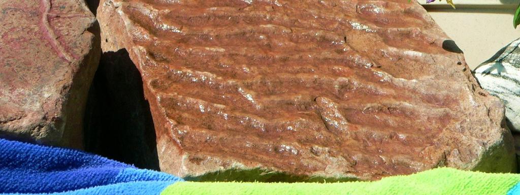
1 These water ripple rocks were not laid down during the ice age by Lake Missoula. The rock strata that they are found in is vertical & not horizontal. Fossilized water ripples are formed on flat horizontal surfaces. These water ripple rocks were formed during the later stages of Noah s Flood, right before the Mountains were formed.[see Hydroplate Theory ] Apparently there were large mats of vegetation floating above including massive amounts of thin branches which were also impacted in the mud at the same time the water ripples were being formed. There s a huge abundance of these water ripple rocks along the Alberton Gorge; however, they are not unique to Alberton alone, but I have also observed them along I 90 on the other side of Clinton, which is past East Missoula, & also along Highway 93 S as you are heading towards Lolo. I have also observed them in the part of the Clark Fork River that runs parallel with Broadway in Missoula. [And this research is ongoing!] In the following picture (West Mountain) the water ripple strata begins in the river below this picture & extends all the way up the side of the mountain above the house in this picture! The mountain is incredibly steep! For perspective, each one of the trees along the side of the mountain is about the same size as the tall pine tree behind the garage! 1


 just past the mountain &")


2 Here s what the mountain (Plateau) on the other side of the river looks like... Here s a view of the river from up above the house. The view of the river is (that direction) just past the mountain & down river. Notice the tilted strata in the river. Some of the strata is almost straight up & down in other places in the Alberton Gorge. The freeway in the picture has 2 lanes going each direction. 2


3 The following pictures are what you see as you enter the town of Alberton along Railroad Avenue from the North West Interstate Highway 90 entrance at mile marker 75. This whole rock face has multi layers of water ripple rocks. The water ripple rocks can also be observed throughout the town & in the surrounding area in people s yards. People use them for decorative purposes. [Before Noah s Global Flood, the boarder between Canada & the USA was about where the Pre-Flood Equator was located. During that time the North Pole was located in Western China around the area of the Gobi Desert & the South Pole was in the Pacific about the location of the Chili Rise (which is just off the coast of South America). The mountains were formed when the plates slid away from the Mid-Ocean Ridge. (All the major mountain chains around the globe lie parallel with the Mid-Ocean Ridge.) Once the New Mountains were formed, the Himalayans became the heaviest part of the earth & immediately caused the earth to begin to roll straight downwards along what is now the 90 th East Ridge below India. See Hydroplate Theory ] 3


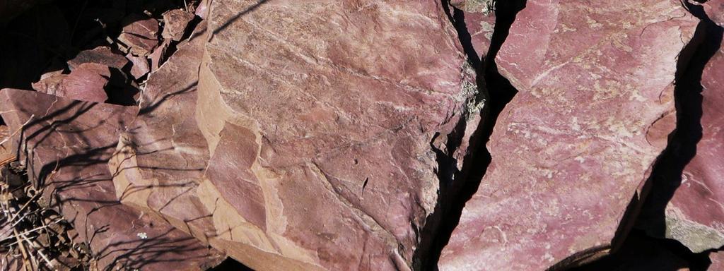
4 The following is a closer view of just below the telephone pole... 4


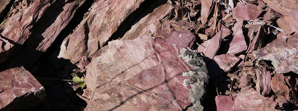
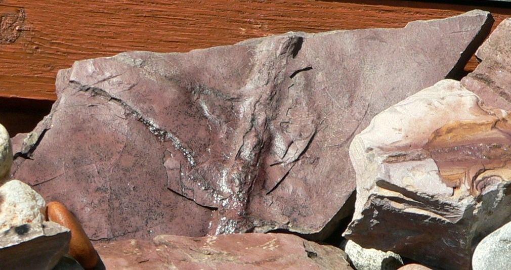
5 Here s another one of just past the telephone pole The water ripples are harder to see, but some of the plant fossils are visible. Those are the irregular criss-crossed lines. They look like thin fossilized branches. Many of them are raised above the water ripples. {& there s other types of plant material found in the strata besides branches. There might even be fossilized critters too that were tangled in the branches. That s one of the items that I m currently looking for.} 5


6 The following are close views of some that are located on the side of West Mountain above an old logging road in a shale formation.. 6
7 7

8 And here s some of my own collection... 8
9 9


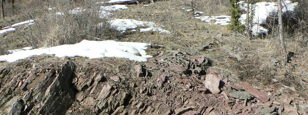
10 After the Mountains were formed, the Mid-Ocean Ridge, being also newly formed, continually heated up the ocean waters for many years. In the process there was a continual cloud of steam year round, causing mega snow fall. Because of the continual steam, the cloud cover continued during the warmer months, so the snow continued to accumulate instead of melting, causing a large portion of land to be covered in ice sheets, including the area where the Alberton Gorge is located. Apparently the water in the Alberton Gorge froze & became an ice plug that held back the waters from Lake Missoula. Later, when the Mid-Ocean Ridge began to cool down, the continual cloud cover caused by the steam also subsided. In turn the ice sheet began to melt. At some point in time (one hot summer?) the Alberton Gorge ice cork melted enough that it gave way to Lake Missoula & the whole thing flowed over the mountains in Eastern Washington in the Dry Falls area, forming the Columbia Gorge. [See The Missoula Flood Controversy & The Genesis Flood by Michael J. Oard ISBN Creation Research Society Books] The following pictures (also taken along Railroad Ave near the I 90 mile marker 75 exit) demonstrate how the glacier deposits rest above the fossilized water ripple strata. The water ripple strata is vertical. The glacier deposits are horizontal. 10


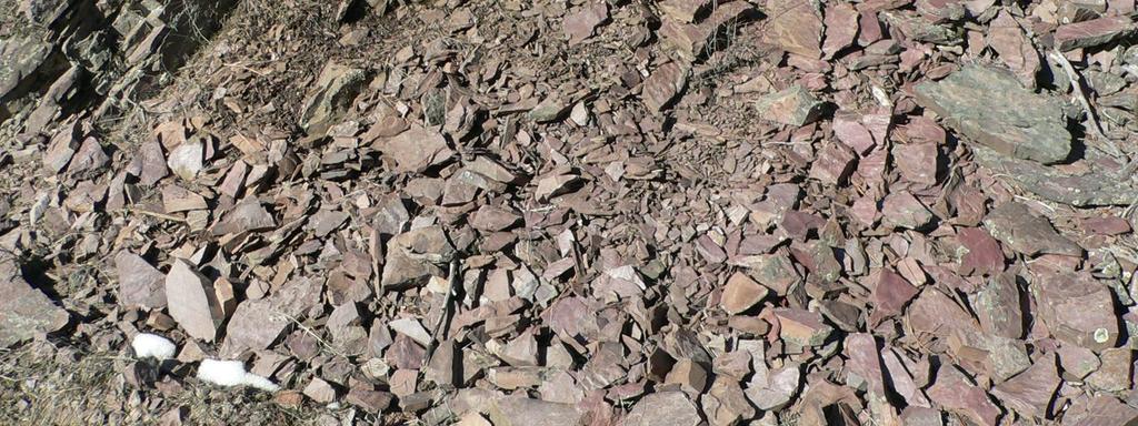
11 Above the water ripple strata the whole area is strewn with these glacier boulders Genesis 10 describes the time in which the ice sheets began to melt, through what people named their sons. See Eber, Peleg & Joktan beginning at page 20. Eber was born 67 years after Noah s Global Flood. See page 6 of This section also testifies to the Earth-Roll. See pages 1&2. 11
Tropical Moist Rainforest
 Tropical or Lowlatitude Climates: Controlled by equatorial tropical air masses Tropical Moist Rainforest Rainfall is heavy in all months - more than 250 cm. (100 in.). Common temperatures of 27 C (80 F)
Exploring Geography. Chapter 1
 Exploring Geography Chapter 1 The Study of Geography Geography is the study of where people, places, and things are located and how they relate to each other. Greek meaning writing about or describing
Earth s Dynamic Surface
 Earth s Dynamic Surface Key Concepts What is the difference between physical and chemical weathering? How do water, ice, and wind change Earth s surface? Changing Earth s Surface What do you think? Read
About places and/or important events Landmarks Maps How the land is, hills or flat or mountain range Connected to maps World Different countries
 What do you think you know about geography? About places and/or important events Landmarks Maps How the land is, hills or flat or mountain range Connected to maps World Different countries What do you
Chapter 6, Part Colonizers arriving in North America found extremely landscapes. It looked different to region showing great.
 Social Studies 9 Unit 1 Worksheet Chapter 6, Part 1. 1. Colonizers arriving in North America found extremely landscapes. It looked different to region showing great. 2. The Earth is years old and is composed
KEY TERMS. Crevasse Glaciers Gravity Ground Water Iceberg
 10.3 SOURCES OF FRESH WATER P G. 3 7 6 OBJECTIVES Describe why run-off is important for rivers Describe how a small stream becomes a large river What is a drainage basin Describe the important and generation
Mount Everest and the Gobi Desert
 Mount Everest and the Gobi Desert 1 Mount Everest is part of the mountain chain known as the Himalaya. Adventurers from all over the world come to try to climb it. Mount Everest is the highest mountain
Movement of the Earth s Crust: Formation of: Mountain s Plateau's and Dome s
 Movement of the Earth s Crust: Formation of: Mountain s Plateau's and Dome s References Information taken from several places including Prentice Hall Earth Science: @ http://www.eram.k12.ny.us/education/components/docmgr/default.php?sectiondetaili
Question #1: What are some ways that you think the climate may have changed in the area where you live over the past million years?
 Reading 5.2 Environmental Change Think about the area where you live. You may see changes in the landscape in that area over a year. Some of those changes are weather related. Others are due to how the
The United States & Canada. A Regional Study of Anglo America
 A Regional Study of Anglo America Landform Regions of the United States & Canada world leaders in agricultural and industrial production because of... VAST LANDS stretch from the Atlantic Ocean on the
Climate.tgt, Version: 1 1
 Name: Key Concepts Choose the letter of the best answer. (5 points each) 1. 2. 3. 4. 5. 6. 7. 8. 9. 10. Date: A city located in the middle of North America experiences extreme temperature changes during
Chapter 1 Section 2. Land, Water, and Climate
 Chapter 1 Section 2 Land, Water, and Climate Vocabulary 1. Landforms- natural features of the Earth s land surface 2. Elevation- height above sea level 3. Relief- changes in height 4. Core- most inner
World Geography Chapter 3
 World Geography Chapter 3 Section 1 A. Introduction a. Weather b. Climate c. Both weather and climate are influenced by i. direct sunlight. ii. iii. iv. the features of the earth s surface. B. The Greenhouse
Chapter 2: Physical Geography
 Chapter 2: Physical Geography Pg. 39-68 Learning Goals for Chp2: q q q q q Explain how the Earth moves in space and why seasons change. Outline the factors that influence climate and recognize different
W he natural resources of Adams
 Above: Houghton Rock, Town of Adams. Following Page: "The Hole in the Rock" on Rattlesnake Mound--both remnants of rock formed by ancient seas hundreds of millions of year5 ago. (Courtesy, H.H. Bennett
discussion of North America s physical features, including its landforms and bodies of
 Chapter 7 Natural Environments of North America Chapter 7 focuses on the natural environments of North America. The chapter opens with a discussion of North America s physical features, including its landforms
(version 3) I. HumAN -Environment Interaction
 I. HumAN -Environment Interaction") (version 3) I. HumAN -Environment Interaction A. Landforms 1. Earth s topography is made up of many different types of landforms. 2. While the planet is covered primarily with water, the four major types
(version 3) I. HumAN -Environment Interaction A. Landforms 1. Earth s topography is made up of many different types of landforms. 2. While the planet is covered primarily with water, the four major types
Geologic Trips San Francisco and the Bay Area
 Excerpt from Geologic Trips San Francisco and the Bay Area by Ted Konigsmark ISBN 0-9661316-4-9 GeoPress All rights reserved. No part of this book may be reproduced without written permission in writing,
Name Date Class. well as the inland, found near the Tropics. 4. In the, or the regions near the Equator, you may find a lush
 WATER, CLIMATE, AND VEGETATION Vocabulary Activity DIRECTIONS: Fill in the Blanks Select a term from below to complete each of the following sentences. CHAPTER 1. The constant movement of water, a process
Unit 2. United States Physical Geography
 Unit 2 United States Physical Geography Physical Geography U.S. extends from the Atlantic to Pacific U.S. is the 3rd largest country U.S. has fertile soils, vast forests, and variety of minerals All major
A physical feature of the Earth s surface
 Earth s Landforms A physical feature of the Earth s surface A physical feature of the Earth s surface LANDFORM Highest of Earth s physical features Highest of Earth s physical features MOUNTAIN Low area
SEDIMENTARY ROCKS. When mountains are first formed, they are tall and jagged like the Rocky Mountains on the west coast of North America.
 SEDIMENTARY ROCKS When mountains are first formed, they are tall and jagged like the Rocky Mountains on the west coast of North America. Over time (millions of years) mountains become old mountains like
Objective 3: Earth and Space Systems
 Name Class Period: Objective 3: Earth and Space Systems 1. The diagram above shows the orbit of the moon around Earth. At which point in the moon s orbit will a person standing on Earth see a waxing crescent
The Example of the Lake Missoula Flood
 Chapter 85 The Example of the Lake Missoula Flood As already noted, uniformitarian hypotheses rarely, if ever, can be supported by extensive geological evidence. Part of this is due to the nature of the
Forces That Shape Earth. How do continents move? What forces can change rocks? How does plate motion affect the rock cycle?
 Forces That Shape Earth How do continents move? What forces can change rocks? How does plate motion affect the rock cycle? Plate Motion Mountain ranges are produced by plate tectonics. The theory of plate
The Little Colorado River
 The Little Colorado River The Little Colorado River Junction of the Little Colorado River and the Colorado Grand Falls of the Little Colorado River The relief/topo map at the right shows the junction of
Unit 1: Geography. For additional information, refer to this website: 1 G e o g r a p h y
 Unit 1: Geography For additional information, refer to this website: http://mryoungtms.weebly.com/ 1 G e o g r a p h y Continents and Oceans SOL USI. 2a Essential Understanding: Continents are large land
Weather Atmospheric condition in one place during a limited period of time Climate Weather patterns that an area typically experiences over a long
 Weather Atmospheric condition in one place during a limited period of time Climate Weather patterns that an area typically experiences over a long period of time Many factors influence weather & climate
Changes to Land 5.7B. landforms: features on the surface of Earth such as mountains, hills, dunes, oceans and rivers
 All the landforms on Earth have changed over time and continue to change. Many of the changes were caused by wind, moving water, and moving ice. Mountains have grown and shrunk. Rivers have cut away land
Developed in Consultation with Florida Educators
 Developed in Consultation with Florida Educators Table of Contents Next Generation Sunshine State Standards Correlation Chart... 7 Benchmarks Chapter 1 The Practice of Science...................... 11
forest tropical jungle swamp marsh prairie savanna pampas Different Ecosystems (rainforest)
") Different Ecosystems forest A region of land that is covered with many trees and shrubs. tropical jungle (rainforest) swamp A region with dense trees and a variety of plant life. It has a tropical climate.
Different Ecosystems forest A region of land that is covered with many trees and shrubs. tropical jungle (rainforest) swamp A region with dense trees and a variety of plant life. It has a tropical climate.
Chapter 1: America s Land Lesson 1: Land and Climate
 Chapter 1: America s Land Lesson 1: Land and Climate Geography: Describe landforms and other physical features of the United States. Geography: Explain how and why climate varies throughout the United
Think about the landforms where you live. How do you think they have changed over time? How do you think they will change in the future?
 reflect All the landforms on Earth have changed over time and continue to change. Many of the changes were caused by wind, moving water, and moving ice. Mountains have grown and shrunk. Rivers have cut
Physical Geography of the United States and Canada Chapter 5 A Land of Contrasts
 Physical Geography of the United States and Canada Chapter 5 A Land of Contrasts Land Area Together the U.S. and Canada cover more than 7 million square miles. In total area, Canada ranks 2 nd and the
Social Studies. Chapter 2 Canada s Physical Landscape
 Social Studies Chapter 2 Canada s Physical Landscape Introduction Canada s geography its landforms and climate - has a great impact on Canadians sense of identity. Planet Earth The earth is divided into
The structure of the Earth and how its motion creates the seasons. The landforms of the earth and the forces that shape the land.
 The structure of the Earth and how its motion creates the seasons. The landforms of the earth and the forces that shape the land. The role of wind and water in creating climate. The different climate and
Hurricanes form over warm ocean water.
 KEY CONCEPT Low-pressure systems can become storms. BEFORE, you learned Moving air masses cause changes in weather A low-pressure system brings stormy weather NOW, you will learn How hurricanes develop
netw rks Guided Reading Activity Essential Question: How does geography influence the way people live? Earth's Physical Geography
 Guided Reading Activity Lesson 1 Earth and the Sun Essential Question: How does geography influence the way people live? Looking at Earth Directions: What are the layers that make up Earth? Use your textbook
The Variety of Maps By ReadWorks
 The Variety of Maps By ReadWorks Maps are known for helping us figure out how to get to a certain location: which road do I take to the ice-cream parlor? How do I get from my house to my best friend s?
Unit 1: Basics of Geography Test Review
 Name Date Period Unit 1: Basics of Geography Test Review Directions: Reading the following sections and complete the questions, charts, and diagrams. Types of Maps Maps that have a particular theme are
12. The diagram below shows the collision of an oceanic plate and a continental plate.
 Review 1. Base your answer to the following question on the cross section below, which shows the boundary between two lithospheric plates. Point X is a location in the continental lithosphere. The depth
Evidence for Continental Drift and The Theory of Plate Tectonics
 Evidence for Continental Drift and The Theory of Plate Tectonics Did you know that the coal that is mined in Pennsylvania was actually formed from tropical plant life near the Equator? How did it travel
4 Changes in Climate. TAKE A LOOK 2. Explain Why is more land exposed during glacial periods than at other times?
 Name Class CHAPTER 3 Date Climate 4 Changes in Climate SECTION National Science Education Standards BEFORE YOU READ After you read this section, you should be able to answer these questions: ES 1k, 2a
Unit 1: Geography GeoTrekkers in the Western Hemisphere. Illustrated Glossary
 Unit 1: Geography GeoTrekkers in the Western Hemisphere Illustrated Glossary adapt to change in order to fit new condi/ons archipelago a group or chain of islands clustered together in a sea or ocean bodies
Read Across America. Listen as I read for facts about Volcanoes. In the Shadow of the Volcano
 Read Across America Listen as I read for facts about Volcanoes. In the Shadow of the Volcano Constructive & Destructive Processes Earth s surface is always changing. Blowing wind and flowing water causes
Space. Earth. EARTH and EARTH and SPACE SPACE. Earth. William B. Rice
 Space Earth rth EARTH and EARTH and SPACE SPACE SCIENCE Earth is covered with mountains, canyons, and oceans. These landforms change over time. Mountains are made. Valleys may become deeper. Earth s landforms
Weather Atmospheric condition in one place during a limited period of time Climate Weather patterns that an area typically experiences over a long
 Weather Atmospheric condition in one place during a limited period of time Climate Weather patterns that an area typically experiences over a long period of time Many factors influence weather & climate
Weather and Climate Summary and Forecast October 2018 Report
 Weather and Climate Summary and Forecast October 2018 Report Gregory V. Jones Linfield College October 4, 2018 Summary: Much of Washington, Oregon, coastal California and the Bay Area and delta region
What are the different ways rocks can be weathered?
 Romano - 223 What are the different ways rocks can be weathered? Weathering - the breakdown of rocks and minerals at the Earth s surface 1. 2. PHYSICAL WEATHERING Rock is broken into smaller pieces with
The Evidence of Earth s Violent Geologic Past
 The Evidence of Earth s Violent Geologic Past Figure 1 The Ring of Fire (Flat Projection) Figure 2 Ring of Fire, (Spherical Projection) Figure 3 Ocean Trenches Page 1 of 10 Figure 4 Kamchatka Peninsula
Not all eruptions are the same. Sometimes, there is a huge explosion. The hot magma shoots
 Natural Disasters A natural disaster is an event that happens in nature. It is an event that can cause a lot of damage. Volcanoes, earthquakes, and tsunamis are all natural disasters. Volcanoes A volcano
Geology of the Pacific Northwest
 Geology of the Pacific Northwest Pat Pringle photo, April 16, 1983 Group sedimentary northeast of Ashford of Eocene age
Earth s Structure and Surface
 Earth s Structure and Surface Structure of the Earth The earth is thought have originated about 4.5 billion years ago from a cloud or clouds of dust. The dust was the remains of a huge cosmic explosion
Landforms in Canada. Canada is made up of three dis;nct types of landforms: Canadian Shield Highlands Lowlands
 Canada s Landforms What is a Landform? A landform is any physical feature of the Earth s surface having a characteris;c, recognizable shape, produced by natural causes. Landforms include major features
Name Date Class. growth rings of trees, fossilized pollen, and ocean. in the northern hemisphere.
 Lesson Outline LESSON 2 A. Long-Term Cycles 1. A(n) climate cycle takes much longer than a lifetime to complete. a. To learn about long-term climate cycles, scientists study natural records, such as growth
1 What Is Climate? TAKE A LOOK 2. Explain Why do areas near the equator tend to have high temperatures?
 CHAPTER 17 1 What Is Climate? SECTION Climate BEFORE YOU READ After you read this section, you should be able to answer these questions: What is climate? What factors affect climate? How do climates differ
Weathering, Erosion, and Deposition Guided Notes
 1. Weathering, Erosion, and Deposition 2. Outline Section 1: Weathering Section 2: Erosion Section 3: Deposition Section 4: Case Study Weathering, Erosion, and Deposition Guided Notes 3. Section 1: Weathering
PSc 201 Chapter 3 Homework. Critical Thinking Questions
 PSc 201 Chapter 3 Homework Critical Thinking Questions 1. (adapted from text) Seawater is denser than fresh water. A ship moving from the Atlantic Ocean into the Great Lakes goes from seawater to fresh
Earth Boot Camp. 3.7B: Investigate rapid changes in Earth s surface such as volcanic eruptions, earthquakes and landslides.
 Earth Boot Camp 3.7B: Investigate rapid changes in Earth s surface such as volcanic eruptions, earthquakes and landslides. Release Questions 2006 #21 (65%) 1. In which of these ways can volcanoes help
Plate Tectonics Practice Test
 Plate Tectonics Practice Test 1. What is the main idea Alfred Wegner proposed in the Theory of Continental Drift that he published in 1915? a. The continents float on a liquid layer that allows them to
Earth s Changing Surface
 Earth s Changing Surface Tectonics What do you think? Read the two statements below and decide whether you agree or disagree with them. Place an A in the Before column if you agree with the statement or
4th Grade Social Studies First Nine Weeks
 4th Grade Social Studies First Nine Weeks Multiple Choice Identify the choice that best completes the statement or answers the question. 1 Name the mountains that are located in the eastern United States.
ORIENTEERING. The challenge is to use the map to decide the best route to complete the course in the quickest time. Orienteering Map. Compass.
 ORIENTEERING Orienteering is similar to a cross-country race but you navigate using a map instead of following a set course. It is an outdoor sport where competitors navigate their own way, you can run,
The Sun and Water Cycle
 The last time you took a shower, did you think about where the water came from? Sure, it came out of the showerhead, but what about before that? The water you used to wash could have spent time in the
Full file at
 Chapter 2 PLATE TECTONICS AND PHYSICAL HAZARDS MULTIPLE-CHOICE QUESTIONS 1. What direction is the Pacific Plate currently moving, based on the chain of Hawaiian Islands with only the easternmost island
4 th Grade PSI. Slide 1 / 107 Slide 2 / 107. Slide 3 / 107. Slide 4 / 107. Slide 5 / 107. Slide 6 / 107. The History of Planet Earth
 Slide 1 / 107 Slide 2 / 107 4 th Grade PSI The History of Planet Earth 2015-11-10 www.njctl.org Slide 3 / 107 Slide 4 / 107 The History of Planet Earth The Structure of Earth Rock Layers Fossils and Relative
Summary. Streams and Drainage Systems
 Streams and Drainage Systems Summary Streams are part of the hydrologic cycle and the chief means by which water returns from the land to the sea. They help shape the Earth s surface and transport sediment
The sun and water cycle
 reflect The last time you took a shower, did you think about where the water came from? Sure, it came out of the showerhead, but what about before that? The water you used to wash could have spent time
Geology 12 FINAL EXAM PREP. Possible Written Response Exam Questions
 Geology 12 FINAL EXAM PREP Possible Written Response Exam Questions Use this study guide to prepare for the written response portion of the final exam. Name FINAL EXAM - POSSIBLE WRITTEN RESPONSE QUESTIONS
The Variety of Maps By ReadWorks
 The Variety of Maps By ReadWorks Maps are known for helping us figure out how to get to a certain location: which road do I take to the ice-cream parlor? How do I get from my house to my best friend s?
AIR MASSES. Large bodies of air. SOURCE REGIONS areas where air masses originate
 Large bodies of air AIR MASSES SOURCE REGIONS areas where air masses originate Uniform in composition Light surface winds Dominated by high surface pressure The longer the air mass remains over a region,
6th Grade Science Sample Assessment Items S6E3c.
 Composition 6th Grade Science Sample Assessment Items Ocean water differs from freshwater in that it has. A. a lower temperature B. a higher temperature C. a higher concentration of silicon dioxide D.
Pangaea to the Present Lesson #2
 Pangaea to the Present Lesson #2 The Earth is a dynamic or constantly changing planet. The thin, fragile plates slide very slowly on the mantle's upper layer. This sliding of the plates is caused by the
What is a landform? These shapes (except for bodies of water) on the earth s surface are all examples of landforms.
 on the earth s surface are all examples of landforms.") Landforms What is a landform? These shapes (except for bodies of water) on the earth s surface are all examples of landforms. archipelago a large group of many islands. The Hawaiian Islands Lighthouse
Landforms What is a landform? These shapes (except for bodies of water) on the earth s surface are all examples of landforms. archipelago a large group of many islands. The Hawaiian Islands Lighthouse
Science EOG Review: Landforms
 Mathematician Science EOG Review: Landforms Vocabulary Definition Term canyon deep, large, V- shaped valley formed by a river over millions of years of erosion; sometimes called gorges (example: Linville
Global Weather Trade Winds etc.notebook February 17, 2017
 Global Weather 1 north pole northern hemisphere equator southern hemisphere south pole 2 We have seasons because of the Earth's tilt The seasons are opposite in the northern and southern hemispheres winter
How do glaciers form?
 Glaciers What is a Glacier? A large mass of moving ice that exists year round is called a glacier. Glaciers are formed when snowfall exceeds snow melt year after year Snow and ice remain on the ground
Earth s Layers. Earth s Surface
 CHAPTER 1 LESSON 3 Earth s Layers Earth s Surface Key Concepts What are Earth s major landforms and how do they compare? What are the major landform regions of the United States? What do you think? Read
Chapter 2 Earth s Interlocking Systems pg The Earth and Its Forces pg
 Chapter 2 Earth s Interlocking Systems pg. 24 55 2 1 The Earth and Its Forces pg. 27 33 Connecting to Your World and Internal Forces Shaping the Earth The Earth is unique in the solar system because it
Weathering and Erosion Board Game Directions
 Weathering and Erosion Board Game Directions 1. Divide the class into teams of three. Two of the groups will be the players and one will hold the answer sheet and tell players if answers are correct or
Natural Disasters. Why Are There Earthquakes? 197 words. The Power of the Earth 221 words. Big Waves! 188 words
 ARTICLE-A-DAY Natural Disasters 6 Articles Check articles you have read: Why Are There Earthquakes? 197 words The Power of the Earth 221 words Big Waves! 188 words The Volcano That Keeps Erupting 228 words
Simple Solutions Social Studies Level 2. Level 2. Social Studies. Help Pages
 Level 2 Social Studies 147 148 adobe houses with bricks made of clay and straw ancestor a family member who lived before us appoint choose; leaders can appoint others barter trading one thing for another
Ch 9.1 Notes. Objective: Be able to explain the theory of plate tectonics and be able to explain evidence that supports it.
 Ch 9.1 Notes Objective: Be able to explain the theory of plate tectonics and be able to explain evidence that supports it. Pangaea Alfred Wegener proposed that land on Earth formed a single, huge landmass.
GEOLOGY OF TODMORDEN MOOR 2 BACKGROUND
 GEOLOGY OF TODMORDEN MOOR 2 BACKGROUND 1) THE CARBONIFEROUS SERIES OF ROCKS The rocks of the Todmorden district are of the Carboniferous Series and were first laid down in an ancient sea, which covered
Diversity, Change and Continuity. History of Life
 Diversity, Change and Continuity History of Life Change throughout the history of Life. A summary of content covered 1 2 3 4 Changes in the atmosphere Changes in climate Geological events Biogeography
Sec$on 1: Geography and Early China. How does China s geography affect the culture?
 Sec$on 1: Geography and Early China How does China s geography affect the culture? Con$nents of the World Label the continents. Where is China located? Where is China located? In your groups, begin filling
Plate Tectonics CHAPTER 17
 Plate Tectonics CHAPTER 17 Layers of the Earth A. Crust- solid, 5-70 km thick Moho Two Types of Crust: Oceanic- ocean floor, more dense then because of more iron Continental-dry land (mostly silicates
3 Erosion and Deposition by Ice
 CHAPTER 12 3 Erosion and Deposition by Ice SECTION Agents of Erosion and Deposition BEFORE YOU READ After you read this section, you should be able to answer these questions: What are glaciers? How do
Hurricanes. Where's the Really Bad Weather 1. What: Rotating wind/rain storm Winds from 75 to 200 mph As big as 600 miles wide
 Where's the Really Bad Weather 1 Hurricanes What: Rotating wind/rain storm Winds from 75 to 200 mph As big as 600 miles wide Where: Start over oceans, fizzle out over land Investigation 1 What is Weather?
FIND PLACES ON GLOBES USING LATITUDE
 GLOBES, MAPS & GRAPHS FIND PLACES ON GLOBES USING LATITUDE AND LONGITUDE LINES FIND PLACES ON MAPS USING A GRID SYSTEM NAME SEVERAL TYPES OF MAP PROJECTIONS AND EXPLAIN THEIR BENEFITS AND SHORTCOMINGS
Shape Earth. Plate Boundaries. Building. Building
 Chapter Introduction Lesson 1 Lesson 2 Lesson 3 Lesson 4 Chapter Wrap-Up Forces That Shape Earth Landforms at Plate Boundaries Mountain Building Continent Building How is Earth s surface shaped by plate
Downloaded from
 SOCIAL STUDIESCLASS - V LESSON-1 GLOBE ANSWER THE FOLLOWING: 1. Name the continents and oceans on the earth. Ans. The seven continents are: a) Australia b) Europe c) Antarctica d) South America e) North
Name. 4. The diagram below shows a soil profile formed in an area of granite bedrock. Four different soil horizons, A, B, C, and D, are shown.
 Name 1. In the cross section of the hill shown below, which rock units are probably most resistant to weathering? 4. The diagram below shows a soil profile formed in an area of granite bedrock. Four different
Grade 8 Science. Unit 1: Water Systems on Earth Chapter 1
 Grade 8 Science Unit 1: Water Systems on Earth Chapter 1 Effects of Water? Churchill River Large Ocean Wave How do you use water? House Hold Use Personal Use Recreational Activities Water Distribution
A journey through the earth history of Australia s Coastal Wilderness Part 3 The backdrop - a 70 million year old plain
 A journey through the earth history of Australia s Coastal Wilderness Part 3 The backdrop - a 70 million year old plain Monaro Plain 3. The Cretaceous Plain The western horizon behind Moruya is dominated
CHAPTER 1: EXPLORING GEOGRAPHY
 CHAPTER 1: EXPLORING GEOGRAPHY Please Do Now: In your PDN section of your binder answer the following with one or two sentences: What is Geography? What is Geography? The study of where people, places,
Mount St. Helens. Copyright 2010 LessonSnips
 Mount St. Helens Washington State is home to the Cascade Mountains, a range of mountains that extends from the Canadian province of British Columbia to northern California. Many of these mountains are
POLAR WEEKEND SHRINKING ICE SHEETS AND RISING SEA LEVEL
 POLAR WEEKEND SHRINKING ICE SHEETS AND RISING SEA LEVEL TOPIC: Shrinking Ice Sheets and Rising Sea Levels PROJECT PERSONNEL: Dr. Robert Bindschadler, Glaciologist, NASA Scientists provide information on
What is a landform? These shapes (except for bodies of water) on the earth s surface are all examples of landforms.
 on the earth s surface are all examples of landforms.") Landforms What is a landform? These shapes (except for bodies of water) on the earth s surface are all examples of landforms. archipelago a large group of many islands. The Hawaiian Islands Lighthouse
Landforms What is a landform? These shapes (except for bodies of water) on the earth s surface are all examples of landforms. archipelago a large group of many islands. The Hawaiian Islands Lighthouse
2/23/2009. Visualizing Earth Science. Chapter Overview. Deserts and Drylands. Glaciers and Ice Sheets
 Visualizing Earth Science By Z. Merali and B. F. Skinner Chapter 6 Deserts, Glaciers and Ice Sheets Chapter Overview Deserts and Drylands Glaciers and Ice Sheets Deserts Geography Categorization of deserts