ECONOMIC GEOLOGY OF THE SIERRA ESTRELLA, MARICOPA AND PINAL COUNTIES, ARIZONA
|
|
|
- Melina Potter
- 6 years ago
- Views:
Transcription
1 ECONOMIC GEOLOGY OF THE SIERRA ESTRELLA, MARICOPA AND PINAL COUNTIES, ARIZONA by Erik B. Melchiorre Department of Geology Arizona State University Tempe, Arizona December, 1992 Arizona Department of Mines and Mineral Resources Funded by the U.S. Geological Survey COGEOMAP Program. Contract # A0872.
2 ABSTRACT The Sierra Estrella in south-central Arizona was examined in order to determine the distribution and character of potential geologic resources. The management, access, and mineral rights to the Sierra Estrella are controlled by the Gila River Indian Community and the U.S. Bureau of Land Management. No areas with high resource potential were identified in the Sierra Estrella. There is low potential for flake mica in the central portion of the range; gold, silver, and copper in epithermal deposits of the south-central portion of the range; dimension stone in the Montezuma Granite; and sand and gravel in the surrounding valleys. The potential exploitation of these resources is highly dependent upon price, local demand, and accessibility.
3 INTRODUCTION The purpose of this study was to determine the distribution and character of potential geologic resources of the Sierra Estrella, Arizona. This report makes no attempt to give estimated tonnages of materials and is intended to provide direction and suggestions for further field exploration. The Sierra Estrella is a northwest-trending mountain range consisting of a single compact ridge that is 38 km in length, and 5 to 7 km wide. The base of the range varies in elevation from 559 m above sea level near the confluence of the Gila and Salt Rivers in the north, to 788 m near the Gila River Indian Reservation boundary in the south. The highest elevations in the Sierra Estrella are an unnamed peak at 1375 m in the north-central part of the range and Montezuma Peak at 1323 m. This study covers approximately 165 km 2 of the Sierra Estrella. Approximately one-quarter of the study area lies within the boundaries of the Gila River Indian Reservation: It is necessary to obtain a permit from the Gila River Indian Community Council to visit this area. The topography is extremely rugged and irregular, making the area accessible only on foot. Several unimproved dirt roads extend to the base of the range on the east and west sides. Preparation of this report included research of previous geologic work and geologic mapping. Mapping was done directly on a topographic base map at a scale of 1:24,000. Aerial photos were used as a field mapping aid. Field work was conducted between September 12, 1991 and May 1, ACKNOWLEDGMENTS I thank the people of the Gila River Indian Community for allowing access to their land. I also thank Dr. S.J. Reynolds of Arizona State University for supervising this project, Dr. J.E. Spencer of the Arizona Geological Survey for providing field and financial support through the U.S. Geological Survey COGEOMAP program, and Nyal Niemuth of the Arizona Department of Mines and Mineral Resources for valuable discussions.
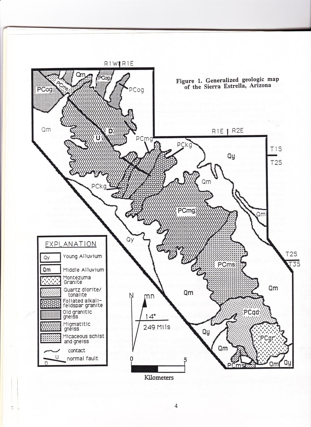
4 PREVIOUS WORK Early investigations of the Sierra Estrella consisted primarily of reconnaissance mapping and basic rock identification (Darton, 1925; Bryan, 1925; Darton, 1933). Bryan (1925) identified a Precambrian gneiss that comprised the bulk of the Sierra Estrella, with later intrusion of Mesozoic (?) granitoidal rocks. The next generation of workers (Wilson et al., 1957; Wilson and Moore, 1959; Wilson, 1969; Wilson et al., 1969) expanded upon earlier work and identified the bulk of the range as Precambrian gneiss with minor amounts of Precambrian schist, and several small granitic plutons of Precambrian, Mesozoic, and Tertiary-Cretaceous (?) age. Paleozoic biotite K-Ar and Precambrian Rb-Sr dates were yielded by the southernmost granite (Pushkar and Damon, 1974) that refutes Wilson (1969) who believed the granite to be Mesozoic in age. The most recent mapping of the northern Sierra Estrella (Sommer, 1982) identified 9 map units of various gneissic and granitic rocks. In addition, a helicopter traverse of the range (Spencer et al., 1985) and a wilderness study area report (Keith, 1989) have examined small portions of the study area in detail. ROCK UNIT DESCRIPTIONS Eight major map units were identified within the Sierra Estrella (Fig. 1), as well as three rock units that are too areally restricted to show on the map (dikes and pegmatites). Each major rock unit is described separately, and where appropriate broken down into sub-units. Organization and relative ages of units are based on lithology and field relationships. A more detailed geologic map of the Sierra Estrella is presented in Arizona Geological Survey Open-File Report
5 Young Quaternary Alluvium These deposits are of inferred latest Quaternary age (Holocene), and include channels and low terraces of small drainages, young alluvial fans, and broad terraces of major drainages. Surfaces are usually underlain by well-sorted sand and silt with local gravel. Minimal soil development is characteristic. Surface clasts generally lack a dark coat of desert varnish. These units are shallowly dissected (<3 m) by active channels. Middle Quaternary Alluvium These deposits are of inferred early to middle Pleistocene age. Deposits are composed of well-sorted sand, silt, and gravel. Cobbles and boulders up to a meter in diameter are also present. These surfaces are moderately dissected (3 to 6 m) by active channels. Surface clasts are moderately to darkly varnished. Some soils are locally developed. This unit is most commonly well cemented by caliche. Pegmatites Numerous pegmatitic dikes crop out in the Sierra Estrella. The pegmatites are abundant in all units except the Montezuma Granite, where they occur only in the margins of the pluton. Intrusion of the pegmatites is both discordant along major fractures and concordant along foliation planes. The pegmatites range in thickness from 5 cm to 4 m, and are generally 90 m to 110 m long. Several exceptionally thick pegmatites are up to 2 km long. Orientation of pegmatite dikes is roughly northwest-southeast and steeply dipping. The pegmatites consist of massive milky white quartz (65% to 90%), large K-feldspar crystals up to 10 cm in diameter (10% to 30%), and sericitized plagioclase (0% to 25%). Locally
6
7 the pegmatites can contain several distinctive accessory minerals. Pegmatites in the pelitic schist and gneiss unit contain many rounded red garnets up to 4 cm in diameter and books of muscovite and biotite up to 20 cm in diameter and 10 cm thick. Sparse crystals of light green beryl and black tourmaline have also been noted in the pegmatites of the pelitic schist and gneiss unit. Pegmatites of the granitic and granitic gneiss units often contain chrysocolla staining and magnetite grains up to 4 cm in diameter. Each pegmatite dike has altered the surrounding country rock in a zone extending 1 to 10 m from the edge of the dike. In the pelitic schist and gneiss unit the alteration is usually to a biotite, chlorite, or muscovite schist. In the granitic rocks the alteration is to a granitic gneiss that is enriched in magnetite and occasionally copper oxides. Aplitic Dikes Dikes of white, fine- to medium-grained, sugary-textured aplite are present in abundance in all units except the Montezuma Granite, where they occur only in the margins of the pluton. Intrusion of the aplite dikes is both discordant along major fractures and concordant along foliation planes. The aplites range in thickness from 1 to 5 m, and are 100 m to 2 km long. Aplite dike trends are roughly northwest-southeast. Composition of the aplite dikes is quartz (38%), plagioclase (33%), and alkali feldspar (29%). Accessory minerals include secondary epidote and magnetite. Each aplite dike has altered the surrounding country rock in a zone extending 1 to 10 m from the edge of the dike. In the pelitic schist and gneiss unit the alteration is usually to a biotite, chlorite, or muscovite schist. In the granitic rocks the alteration is to a granitic gneiss that is enriched in magnetite and sparse copper oxides.
8 Mafic Dikes A series of northwest-trending dikes of grey-green to black mafic rock that is fine to medium grained are found throughout the range, cross-cutting all units of Precambrian age. Intrusion is discordant with local crystaloblastic foliation and contacts with the surrounding country rock are sharp and well defined. All dikes lack a strong foliation and seem to post-date deformation. The dikes can be divided into two populations. The small dike group consists of dikes 1 to 3 m in width, 25 m to 1 km in length, and dipping 70 to 90 to the southwest. These dikes are typically fine grained and have compositions ranging from basaltic to amphibolitic. Both types of dikes seem to be passively emplaced due to the unaltered persistent foliation above and below the dikes, and a general lack of drag folds. The large dike group consists of dikes generally 3 to 6 m in width, 0.5 to 5 km in length, and dipping 40 to 60 to the southwest. The margins of these dikes are aphanitic but the rock quickly grades into a medium to coarse grained amphibole-pyroxene gabbro. Composition is plagioclase (30 to 65%), pyroxene and amphibole (25 to 45%), quartz (0 to 5%), clinopyroxene (0 to 5%), and olivine (0 to 1%) with minor chlorite, muscovite, and magnetite. These large dikes also contain subophitic zones with pyroxene crystals up to 5 cm in length. These diabase dikes are similar in composition, intrusive style, and general appearance to the 1100-Ma diabase intrusions of the Apache Group and Troy Quartzite. Montezuma Granite The Montezuma Granite crops out in the southern portion of the Sierra Estrella. This monzogranitic pluton is medium grained and nonporphyritic at its margins, but quickly grades to coarse grained and porphyritic towards the center. This unit is light tan in color on weathered surfaces and a light grey on fresh surfaces. The mode of this compositionally homogeneous granite, estimated from stained slabs and thin sections, is quartz (32%), alkali feldspar (31%),
9 plagioclase (30%), and biotite (7%). The corresponding ternary plot indicates that this unit is a monzogranite. Accessory minerals include muscovite, sphene, zircon, magnetite, and allanite. Sparse epidote and chlorite were noted as secondary alteration. The distinctive characteristic of this rock is a scattering (5%) of large rectangular alkali feldspar phenocrysts, the largest of which are well zoned and up to 6 cm in length. Plagioclase and quartz grains are equigranular in size, ranging from 2-4 mm. This pluton is typical of 1400-Ma granites in the region in terms of intrusive style, texture, gamma radiation levels, and rock composition. Xenoliths and a weak foliation are found in this pluton near the margins. The Montezuma Granite represents the youngest episode of Precambrian plutonism in the Sierra Estrella range. This unit has a Rb-Sr date of 1380-Ma (Pushkar and Damon, 1974). Quartz Diorite/Tonalite This dark-grey to light-grey massive quartz diorite/tonalite is located on the slopes south of Montezuma Peak in the Sierra Estrella. This pluton is medium grained on its margins and coarser grained towards the center. This unit has a weak foliation near the contact with other units. Weathered outcrops are a mottled black and brown color. Most outcrops are irregular, deeply weathered, and surrounded by large piles of grus. The mode, estimated from stained slabs and thin sections, is quartz (15 to 24%), plagioclase (70 to 75%), and biotite (6 to 10%). The corresponding ternary plot indicates that this rock ranges from a quartz diorite to a tonalite. Equigranular plagioclase and quartz grains range in size from 2-4 mm, while biotite grains average 1 mm. The principle mafic constituent is biotite, although minor amounts of hornblende have been noted in some samples. Accessory minerals include magnetite, ilmenite, allanite, sphene, zircon, and secondary epidote and muscovite. The pluton intrudes the micaceous schist and gneiss unit to the north, forming an injection zone up to 0.5 km wide. Numerous xenoliths of pelitic, calc-silicate, amphibolite, and granitic gneisses are found in this injection zone. However, xenoliths are found with less
10 abundance through the entire unit Most xenoliths are extensively folded and indicate a deformation event prior to intrusion. Inclusions range in diameter from a few cm to large bodies tens of m across. The larger bodies are less common and may be roof pendents. Average xenolith diameter is cm. The abundance of inclusions in the injection zone indicates shallow emplacement (8-17 km or shallower) in a brittle country rock, and that stoping was an important mechanism of magma emplacement. Foliated Alkali-Feldspar Granite The Precambrian Foliated Alkali-Feldspar Granite is a suite of variably foliated granitic to granodioritic plutonic rocks that are medium to coarse grained and grey to pinkish grey on fresh surfaces. Exposure is predominantly in the central part of the map area. The rock varies from a highly-deformed, well-foliated augen gneiss to an almost undeformed homogeneous granite-granodiorite. Weathered outcrops form spalling, spheroidally weathered tan-to-brown boulders that are surrounded by grus-covered slopes. This unit produces a lighter color soil than the surrounding migmatitic gneiss. This unit intrudes the older migmatitic gneiss and was probably emplaced during a period of intense deformation. The compositional mode, estimated from hand samples and thin sections, is quartz (38 to 28%), alkali-feldspar (30 to 20%), plagioclase (35 to 29%), biotite (8 to 15%), and muscovite (<1%). Accessory minerals include allanite, apatite, sphene, hornblende, secondary epidote, and magnetite. A distinctive characteristic of this unit is a scattering (5 to 10%) of alkali-feldspar phenocrysts that are 0.5 to 7 cm in diameter. Small regions at the center of the plutons lack the phenocrysts however. When present, the phenocrysts are rectangular with slightly rounded corners in the less deformed exposures and are rounded to lenticular augen in the highly deformed outcrops. This unit has numerous inclusions of the surrounding Migmatitic Gneiss and Amphibole Gneiss. These inclusions occur as thin, elongate sheets up to 10 m in length. Small, rounded xenoliths up to 0.5 m in diameter were also noted. This unit is quite similar to the Komatke Granite (Reynolds, 1985) of the adjacent South
11 Mountains in lithology, weathering style, deformation style, gamma radiation levels, and general appearance. Both rock units are on strike with each other across the Gila River valley. Old Granitic Gneiss The Old Granitic Gneiss is a strongly foliated to massive granitic gneiss. Weathered outcrops are low, blocky, and a dark grey to dark brown due to desert varnish. Fresh surfaces are light to dark grey. This Precambrian unit is discordantly cut by numerous small bodies of Amphibolite Gneiss. Composition of the Old Granitic Gneiss is plagioclase (30 to 40%), alkalifeldspar (2 to 35%), quartz (15 to 25%), biotite (5 to 15%), and retrogressive muscovite (0 to 3%). Accessory minerals include chlorite, magnetite, sphene, and secondary epidote. Protolith is uncertain due to the high metamorphic grade and a general lack of relict features, but may be plutonic based on mineral compositions and weak mineral textures observed. This unit seems to have intruded the migmatitic gneiss in places. The local high level of deformation and structural relationships indicate this unit was emplaced prior to deformation. The contacts between the Migmatitic Gneiss and the Old Granitic Gneiss are difficult to accurately locate, as the two units grade into each other over a distance of 50 to 100 m, and most original contact relations have been obliterated. Bodies of swirled and migmatized Old Granitic Gneiss also exist within the Migmatitic Gneiss unit, which adds to difficulties in separating the two units. Migmatitic Gneiss The Precambrian Migmatitic Gneiss is an undifferentiated unit mainly composed of
12 interlayered migmatitic rock with minor quartzofeldspathic gneiss, Old Granitic Gneiss, amphibole gneiss, marble, and Biotite-Muscovite Schist and Gneiss. This unit usually forms serrated ridges of dark-colored jagged rock in the central and northern portion of the map area. The weathered surfaces are thickly coated with desert varnish. Layering within the unit ranges from 1 cm to 10+ m. This unit has a well-defined crystaloblastic foliation imparted by compositional layering and alignment of micas. Small-scale folds and other structures <1 m are locally common. All minor sub-units of the Migmatitic Gneiss, with the exception of the Amphibole Gneiss and the Marble units, are thin layers of other major units seen elsewhere in the range. The amphibole gneiss and marble units are only found within the Migmatitic Gneiss. The migmatitic sub-unit is light to dark grey on fresh surfaces. Modal composition varies locally, but usually is one-third quartz and two-thirds feldspar. Muscovite, biotite, hornblende, secondary epidote, and magnetite constitute less than 10% of the total rock. This fine- to medium-grained unit has sheet-like intrusions of the Foliated Alkali-Feldspar Granite up to 5 m in diameter. The migmatite has layering that is swirled and intensely deformed, with the most intensely deformed areas being adjacent to intrusions of the Foliated Alkali-Feldspar Granite. Some areas, especially in the northern portion of the map area, have well-developed layering that may represent relict bedding. The protolith of the migmatite sub-unit is uncertain due to the high metamorphic grade and a general lack of relict features, but is partly sedimentary based on the highly variable mineral compositions. Amphibole Gneiss The Amphibole Gneiss sub-unit of the Migmatitic Gneiss is composed of interlayered amphibolite, quartzite, and minor biotite-muscovite schist and gneiss. This unit is concordant with the foliation of the surrounding Migmatitic Gneiss, but discordant regions do exist. Layering of the sub-units is on the order of 0.5 to 2 meters. The amphibolite is grey to black on both fresh and weathered surfaces, and is fine grained. Composition is hornblende (45 to 90%), plagioclase (5 to 35%), quartz (0 to 20%), and biotite (0 to 10%). Accessory minerals include minor chlorite, actinolite, apatite, magnetite, and zircon. Hornblende is usually subhedral and 1 to 5mm in length. Parallel alignment of hornblende and biotite define
13 foliation. Layers within the amphibolite are 1-10 cm thick and remarkably homogeneous along the strike of foliation. This sub-unit weathers to produce a black sand and flat, low, grus-covered outcrops. Quartzite is coarse grained with no visible accessory minerals. White to light grey in color, these layers of quartzite within the amphibolite are massive and homogeneous. Layers of this sub-unit are 0.5 to 2 m thick. The quartzite is more resistant than the surrounding amphibolite and forms ridges up to 2 m high. Composition is quartz (70 to 90%), alkali feldspar (5 to 15%), and plagioclase (5 to 15%). Minor Biotite-Muscovite Schist and Gneiss is also associated with this unit at its contacts with the surrounding Migmatitic Gneiss. The amphibolite and quartzite probably represent metamorphosed mafic sills and quartz veins. Marble The Marble sub-unit of the Migmatitic Gneiss is a light tan to brown on both weathered and fresh surfaces, and is fine to medium grained. These marbles and associated calcareous rocks exhibit compositional banding on the scale of 1 to 5 cm and form layers up to 30 m thick. Weathered surfaces have a distinctive "elephant-skin texture" that highlights compositional banding. The marble is impure, containing quartz (0 to 20%) and alkali feldspar (0 to 5%) in addition to calcite and dolomite. Accessory minerals within the marble and associated calcareous rocks include minor garnet, epidote, muscovite, subhedral sphene, diopside, and tremolite. Soils surrounding these outcrops tend to be very well cemented with caliche. Micaceous Schist and Gneiss The micaceous schist and gneiss unit is broken up into two sub-units. This rock may be part of the Pinal Schist based on lithology, weathering style, and deformation style. Pinal schist is normally a greenschist-grade rock of uniform lithology, but metamorphic grade can be locally elevated to amphibolite grade near batholiths (e.g., The Table Top and Javelina Mountains near the Maricopa batholith). The lithological uniformity of the micaceous schist and gneiss also links it to the Pinal Schist, which is uniform over large regions due to its origin. Quartzofeldspathic Schist and Gneiss This massive fine-grained rock is light to dark
14 grey in color and varies locally from a gneiss to a schistose gneiss. Parallel orientation of micas defines schistosity, whereas gneissic layering is defined by both gradational changes in mineralogy and small fine- to coarse-grained veins of quartz and feldspar. The veins are abundant through most of the unit, run parallel to foliation, have sharp contacts with the country rock, and range from 0.5 to 4 cm thick. Ptygmatic structures are present in these pegmatitic to aplitic veins. Modal composition is quartz (30 to 35%), feldspar (40 to 60%), biotite (8 to 20%), and muscovite (0 to 5%) with minor epidote, magnetite, zircon, and illmenite. This unit rarely has strong layering on the order of 1 to 10 cm, and more commonly is homogeneous and massive with weak to nonexistent layering. Protolith for this rocks is most likely a muddy arkosic sandstone. Biotite-Muscovite Schist and Gneiss These pelitic schists and gneisses are composed mainly of plagioclase (30 to 40%), quartz (15 to 40%), biotite (5 to 20%), and muscovite (2 to 15%). Almandine garnet is present in the pelitic rocks (1 to 20%) and forms rounded porphyroblastic grains up to 1.7 cm in diameter. Sillimanite is the only aluminum silicate present in the pelites, and it occurs in two varieties. The first variety occurs as fibrous needles up to 0.7 mm long, whereas the second generation of sillimanite occurs as coarse-grained mats of various sizes. A few samples have a high (2 to 10%) carbonate content and exhibit a "pitted" texture on weathered surfaces. Accessory minerals include apatite, zircon, alkali-feldspar, tourmaline, and magnetite. Minor amounts of the secondary minerals epidote, sericite, and chlorite are also present. Foliation in these pelites is defined by the long axis of quartz and feldspar, and the parallel alignment of the micas and sillimanite needles. In the pelitic gneiss the segregation of mafic minerals and quartz+plagioclase imparts gneissic banding. Based on the assemblage of minerals present, the protolith of the pelitic schists and
15 gneisses is inferred to be a shale or sandy mudstone with a scattered carbonates. ECONOMIC GEOLOGY Nonmetallic Resources Sand and Gravel Young Quaternary sands and gravels (Qy in Figure 1) are by far the most abundant commercial resource. These reserves are present in washes and as surrounding overbank deposits. These deposits have been historically exploited on a very small scale as a construction aggregate and as landscaping material. However, the overall abundance of similar types of deposits within the greater Phoenix area and transportation costs make this resource of limited value for local construction only. The areas of middle alluvium (Qm in Figure 1) are not suitable for sand and gravel extraction as these deposits are well cemented by caliche with depth. Quartz Many pegmatites in the Sierra Estrella are a source of very pure quartz that may be suitable for use as smelter flux, roofing granules, and landscaping material. However, like most deposits within the Sierra Estrella, the problem of expensive transport from the rugged range to market makes this commodity marginally profitable at best. Dimension Stone The Montezuma Granite in the southern Sierra Estrella is well suited for use as a decorative dimension stone. This hard, unaltered, and attractive stone has an appealing light pink to tan color. This stone may also have use as rip-rap. Since this resource is located adjacent to a well-maintained dirt road it may be profitable as potential quarry sites can be easily reached. The local demand for this product and market price would be the overriding factors determining profitability. Feldspar The occurrence of large feldspar masses in the pegmatites of the Sierra Estrella may also be of commercial interest. Feldspar is used in mild abrasives, high-temperature ceramic production, and the manufacture of vitrified products. In a finely ground form is may be used as non-reactive filler in paint and plastics. The small tonnages available and the difficult
16 accessibility of the deposits make production of this resource a currently unfavorable venture. Mica Commercial grade mica is found within the pegmatites and metamorphic rocks of the Sierra Estrella. These deposits have been worked in the past with marginal success (Krason et al, 1982). The pegmatites contain muscovite books up to 20 cm square and 10 cm thick. This mica splits well but up to 50% is bent, twinned, and contains magnetite grains that make it unsuitable for use as sheet mica. Though this mica is unsuitable for sheet mica, it can be used as a source of flake mica. Flake mica is ground to a mesh size of 80 to 325 and is used in the manufacture of cements, drilling mud, reflective paint, welding rods, and asphalt shingles. Muscovite schist surrounding the pegmatites is also a good source of flake mica. Analysis of the schist (Wilson, 1969) indicated that the rock is composed of up to 21.8 % muscovite. Current mining of flake mica is usually of deposits that are >50 % mica. A similar schist was mined recently in the Buckeye Hills. Overall, the pegmatitic mica is too sporadic in occurrence and the schist is of too low a grade to warrant mining at the current price range (Table 2). Despite this, there have been efforts to produce mica at two locations within the Sierra Estrella. Several other mica deposits have been prospected (Table 1). Beryl Beryl crystals up to 10 cm in diameter and 26 cm long have been found within the pegmatites of the Sierra Estrella. Rare light-green beryl crystals are only found within a few of the larger pegmatites. Beryl is a source of beryllium which is used in some ceramics, electronics, metal alloys, and nuclear reactors to moderate neutrons. Because of the scarcity of beryl within the pegmatites and the limited demand for beryllium, these deposits have little prospect for development. Garnet Red euhedral garnets up to 4 cm in diameter and anhedral garnet masses up to 10 cm in diameter are found within pegmatites of the Sierra Estrella. Garnets are also found scattered through some of the pelitic rocks. Garnet is a popular semi-precious stone, but the garnets of the Sierra Estrella are not of gem quality due to numerous mineral inclusions. Garnet
17 also has industrial uses as an abrasive agent. The garnet however is not found in enough abundance to compete with other larger and more accessible deposits that currently supply the market. Tourmaline Black tourmaline crystals up to 4 cm in diameter and over 30 cm in length compose up to 2 % of some pegmatites within the Sierra Estrella. This tourmaline does not possess chatoyance or "cats-eye" properties, but may be considered a potential resource if it is found to possess favorable piezo-electric properties. The tourmaline is hard, and cuts and polishes well. There is little current domestic market for tourmaline. Metallic Resources Copper All observed copper within the Sierra Estrella occurs as copper oxides within the pegmatites and surrounding country rock. Copper values range up to 8,950 parts per million (ppm) (Keith et al, 1989) but only in small discontinuous lenticular bodies in the pegmatites. As a result, the copper contained within the pegmatites would be costly to exploit. When this consideration is combined with the low tonnages of ore present, the Sierra Estrella presents itself as an unfavorable prospect for copper production. Gold and Silver Pegmatites of the Sierra Estrella contain an average of 15 to 40 parts per billion (ppb) gold with one pegmatite reportedly containing up to 23 ppm gold and 13.5 ppm silver (Korzeb, 1988). While most of the pegmatites are not presently an economically feasible source of gold or silver, they do provide a possible source for gold placer deposits. Since 1980 there have been over 75 placer claims located in the alluvium on the western side of the Sierra Estrella. These claims have not been worked beyond a few exploration trenches (as of 1991). Table 1. Commodity price average for 1991
18 Commodity Quartz Feldspar Mica Gold Silver Copper Beryl Garnet Dimension Stone Price $10-30 per ton $50-80 per ton $40-70 per ton $362 per ounce $4.03 per ounce $1.05 per lb. $60-90 per stu $ per ton $20-60 per ton MINING HISTORY The proximity of early transcontinental travel routes indicate that the Sierra Estrella was probably explored and prospected prior to In 1868 the U.S. Land Office noted that several partially developed copper mines were located in T.3S., R.2E. In 1920 there were nine load claims filed for the same township and range (U.S. Mineral Surveys No and 3658) that indicated development was restricted to a small stope, discovery cuts, and a few shallow pits. No other records were found that discuss mining activity in the Sierra Estrella prior to Descriptions of other undated workings and workings postdating 1920 are given in the site descriptions. SITE DESCRIPTIONS
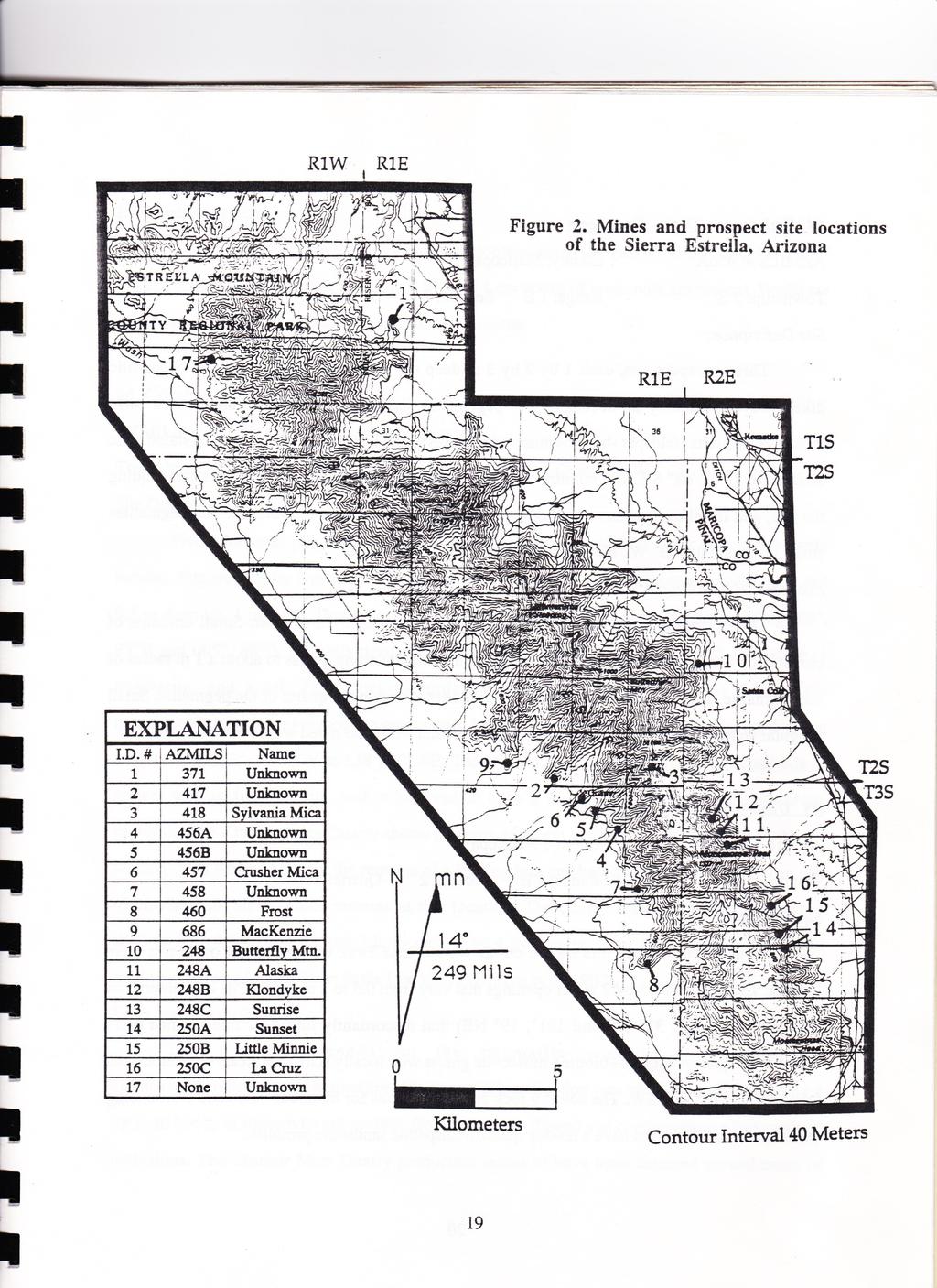
19 The following section describes in detail the workings and geology of the major prospects in Table 2. Location of these sites is denoted on Figure 2 by the corresponding ID number from Table 2. Additional information on some sites is available on file at the Arizona Department of Mines and Mineral Resources under the appropriate AZMILS number or name. Table 2. Mines and prospects of the Sierra Estrella, Arizona [AZMILS- Arizona Mineral Industy Location System] I.D. # AZMILS Name Workings County Twn. Shp Unknown Prospect and Adit Maricop a Unknown Prospects Maricop a Sylvania Mica Prospect Maricop a 4 456A Unknown Prospects Maricop a 5 456B Unknown Prospects Maricop a Crusher Mica 20x10x8ft cut Maricop a Unknown Prospects Maricop a Frost Prospects Maricop a Rng. Sec. Qtr. Minerals or Commodities 1S 1E 19 NE Cu, Mica 2S 1E 34 SE Cu 2S 1E 36 C Gold, Cu, Feldspar, Mica 3S 1E 2 SE Mica 3S 1E 2 NW Cu 3S 1E 2 NW Mica, Qtz, Tourmaline 3S 1E 12 SW Cu 3S 1E 24 C Mica, Cu, Qtz, Feldspar,Beryl, Tourmaline 2S 1E 33 SE Cu, Mica MacKenzie Prospects Maricop a Butterfly Mtn. Prospect, Adit Pinal 2S 2E 19 SW Mica, Qtz A Alaska Prospects Pinal 3S 2E 7 NE Cu B Klondyke Prospects Pinal 3S 2E 6 SE Cu C Sunrise Adit, Prospect Pinal 3S 2E 6 SE Cu, gold, silver A Sunset Prospects Pinal 3S 2E 20 NE Cu B Little Minnie Prospects Pinal 3S 2E 17 SE Cu C La Cruz Prospects Pinal 3S 2E 17 NE Cu 17 None Unknown Prospects Maricop a 1S 1W 27 NE Cu
20
21 #4 Unknown Three Prospects AZMILS #: 456A County: Maricopa Township: 3 S Range: 1 E Section: 2 Quarter: SE Site Description: Three prospect pits, each 1 by 2 by 3 m deep are located in two 0.5 m wide pegmatitic dikes of approximately 20 m length. The pegmatites discordantly intrude a fine-grained early Proterozoic quartz+feldspar+biotite+muscovite gneiss with locally schistose areas. Crystaloblastic foliation is 030, 48 SE. The country rock is homogeneous for hundreds of meters surrounding the site, and is believed to have a muddy quartzofeldspathic sandstone protolith. The pegmatites strike north and dip 75 W. No signs of recent activity were seen. Economic Mineralization: The pegmatite contains quartz+feldspar+biotite+ muscovite+garnet. Small amounts of chrysocolla and possibly other copper oxides stain the surrounding gneiss to about a 1 m radius of the pegmatite. Highest concentration of copper oxides is within the quartz of the pegmatite. Small irregular shaped bodies (<1 cm diameter) of chrysocolla were also noted within the quartz. #5 Unknown Two Prospects AZMILS #: 456B County: Maricopa Township: 3 S Range: 1 E Section: 2 Quarter: NW Site Description: In addition to the 3 pits shown on the Montezuma Peak Quadrangle, 4 other pits were located. The pits are all 1 by 2 meter openings that vary from 0.5 to 2 m depth. Pits are centered on 2 pegmatites (098, 32 NE and 101, 19 NE) that discordantly intrude a fine-grained early Proterozoic quartz+feldspar+biotite+ muscovite gneiss with locally schistose areas. Crystaloblastic foliation is 130, 40 SW. The country rock is homogeneous for hundreds of meters surrounding the site, and is believed to have a muddy quartzofeldspathic sandstone protolith.
22 Economic Mineralization: The pegmatite contains quartz+feldspar+biotite+muscovite+garnet+ tourmaline. No copper mineralization was noted, but abundant 4 by 4 by 1 cm books of muscovite are present. Books are often flawed and contain opaque (magnetite?) inclusions. #6 Crusher Mica Quarry AZMILS #: 457 County: Maricopa Township: 3 S Range: 1 E Section: 2 Quarter: NW Site Description: Five additional pits and a trench not shown on the Montezuma Peak Quadrangle were located. Pits are all 1 by 2 m openings that vary from 0.5 to 2 m depth. The trench is 4 m long and 0.5 m deep by 1 m wide. Three pits and the trench are centered on 2 pegmatites trending 003, 85 E and 005, 88 E. An epidotized fault plane (007, 42 W) extends through the saddle, 1 pegmatite, and a pit. Pegmatites discordantly intrude a fine-grained early Proterozoic quartz+feldspar+biotite+muscovite gneiss with locally schistose areas. Crystaloblastic foliation ranges from 173, 42 NW to 138, 12 SE. The country rock is homogeneous for hundreds of meters surrounding the site, and is believed to have a muddy quartzofeldspathic sandstone protolith. The Crusher Mica Quarry shows no signs of recent activity. A road leads up to the old loading dock where there are the remains of a loading bin, crusher, and screen sieves. A 1 m pile of crushed and sieved mica remains at this location. The quarry consists of three terraces, 3 shallow 1 by 1 by 1 m pits, and 2 large cuts (3 by 4 by 2 meters and 7 by 3 by 2 meters). Last production seems to have been in the late 1950's (Krason et al, 1982). Economic Mineralization: The pits and trench on the pegmatite contains quartz+feldspar+ biotite+muscovite+garnet+tourmaline. No copper mineralization was noted, but abundant 4 by 4 by 1 cm books of muscovite are present. Books are often flawed and contain opaque (magnetite?) inclusions. The Crusher Mica Quarry production seems to have been centered around zones of
23 coarse mica schist that are 3+ meters wide. The mica flakes tend to constitute 25%+ of the rock in this zone, and flakes average 1 to 2 cm in diameter. Flakes tend to be irregularly shaped, flawed, and crumpled. #7 Unknown two prospects AZMILS #: 458 County: Maricopa Township: 3 S Range: 1 E Section: 12 Quarter: SW Site Description: Two prospect pits are present in a stream drainage. The pits are within 2 m of each other and have been partially filled in with sandy stream sediment. Pit dimensions are 1.5 by 2 m, and 1 m deep. The original pit depths are unknown due to stream sediment infilling. The pits are centered on a concordantly intruded quartz+feldspar pegmatite 1.5 m wide, 10+ m in length, and striking 005 and dipping 32 SE. The surrounding country rock is a fine-grained early Proterozoic quartz+feldspar+biotite+ muscovite gneiss with locally schistose areas. Foliation is 008, 31 SE. The country rock is homogeneous for hundreds of meters surrounding the site, and is believed to have a muddy quartzofeldspathic sandstone protolith. Economic Mineralization: Small amounts of chrysocolla and possibly other copper oxides stain the surrounding gneiss to about a 1 meter radius of the pegmatite. Highest concentration of copper oxides is within the quartz of the pegmatite. Small irregularly shaped bodies (1-3 cm diameter) of chrysocolla were also noted within the quartz.
24 #9 MacKenzie Copper Prospect AZMILS #: 686 County: Maricopa Township: 2 S Range: 1 E Section: 33 Quarter: E Site Description: Numerous prospect pits that have been mostly filled in with sandy sediment are present. The pits are centered on a discordantly intruded quartz+feldspar pegmatites 0.5 to 0.25 m wide, 5+ m in length, and striking 064 and dipping approximately 80 NW. The surrounding country rock is a fine-grained early Proterozoic quartz+feldspar+biotite+muscovite gneiss with locally schistose areas. Crystaloblastic foliation is 042, 75 NW. The country rock is homogeneous for hundreds of meters surrounding the site, and is believed to have a muddy quartzofeldspathic sandstone protolith. The country rock is altered approximately 2+ meters from either side of the pegmatite. Average pit dimensions are 1.5 by 2 m, and 1 m deep. The exceptions are 2 pits in the saddle that are 1 by 1 by 3 meters deep. Original pit depths are unknown due to sediment infilling. Small piles and scattered samples of chrysocolla stained quartz are located around the pits. Economic Mineralization: Most pits contain small amounts of chrysocolla and possibly other copper oxides that stain the surrounding altered country rock to about a 1 m radius of the pegmatite. Highest concentration of copper oxides is within the quartz of the pegmatite. Small irregularly shaped bodies (1 to 3 cm diameter) of chrysocolla were also noted within the quartz. One location has copper oxide mineralization that is 5 to 6% of the rock, and composed of small irregularly shaped bodies (3 to 6 cm diameter) of chrysocolla diseminated throughout a zone for 0.5 meter surrounding the pegmatite.
25 #10 Butterfly Mtn. Area Mica Deposit AZMILS #: 248 County: Pinal Township: 2 S Range: 2 E Section: 19 Quarter: SW Site Description: A prospect shaft (shown as an adit on the Montezuma Peak quadrangle topographic sheet) extends about 8 to 9 m into a pegmatitic dike. The pegmatite discordantly intrudes a fine-grained early Proterozoic quartz+feldspar+biotite+muscovite gneiss with locally schistose areas. Crystaloblastic foliation is 012, 29 SE. The country rock is homogeneous for hundreds of meters surrounding the site, and is believed to have a muddy quartzofeldspathic sandstone protolith. The pegmatite strikes 135, 75 SW and is approximately 2 m wide at the shaft. The pegmatite lenses out 11 m to the southeast and 17 m to the northwest of the shaft. Economic Mineralization: The pegmatite contains quartz+feldspar+biotite+ muscovite+garnet. The books of biotite are small and sparse, while the muscovite books are up to 10 cm long by 8 cm wide, by 5 cm thick. The books of muscovite are irregular shaped, flawed, and fairly plentiful in a zone 0.5 m wide adjacent to the footwall. Garnets are less than 1 cm in diameter, grossular to spessertine in composition, highly fractured, and retrogresively metamorphosed. #13 Sunrise AZMILS #: 249C County: Pinal Township: 3 S Range: 2 E Section: 6 Quarter: SE Site Description: Remnants of a small hand-made aerial tram were still at the site. The rusted cables and rotted poles of the tram extend along the trail from the former loading bin to the mine site. Ore samples were found in abundance at the old loading bin and all along the tram route. At the mine site a prospect pit measuring 2 by 2 by 1 m and an adit 2 m high and 2 m wide extends inward approximately 18 m. The adit was driven into the hanging wall zone of a discordantly intruded quartz pegmatite that is 3 m wide, 25+ m in length, striking 134, and dipping 48 SW. At the
26 back of the adit the pegmatite narrows to 30 cm. No recent work on the adit was evident, and the entrance was partially collapsed. The pegmatite is coarsely crystalline, vitreous, colorless to white, brecciated body. The surrounding country rock is a fine-grained early Proterozoic quartz+feldspar+biotite+muscovite gneiss with locally schistose areas. Foliation is 058, 34 SE. The country rock is homogeneous for hundreds of meters surrounding the site, and is believed to have a muddy quartzofeldspathic sandstone protolith. Site History and Economic Mineralization The site was apparently active prior to 1868, based on a U.S. Land Office report of that year that states that, "Several copper mines, as yet but partially developed," were located at the site (See also AZMILS # 249A, 249B, 250B, and 250C). In 1920 a lode claim was surveyed at the site, but not patented. The same claim was resurveyed in Both surveys were performed by the Sacaton Copper Company. In April of 1963 an investigation of the site revealed no recent improvements to the site. The same study yielded ore samples from the back of the adit that assayed as follows: 3% copper 0.22 ounce per ton gold 0.35 ounce per ton silver Small amounts of chrysocolla and possibly other copper oxides stain the surrounding gneiss to about a 1 m radius of the pegmatite. Highest concentration of copper oxides is within the hanging wall of the quartz pegmatite. Small irregularly shaped bodies (1 to 5 cm diameter) of chrysocolla, limonite, and hematite were also noted within the quartz.
27 #14 Sunset AZMILS #: 250A County: Pinal Township: 3 S Range: 2 E Section: 20 Quarter: NE Site Description: At this site shallow excavations that are centered on several discordantly intruded quartz+feldspar pegmatites 0.5 to 1 m wide, 10+ m in length, and striking N-S and dipping SE. The surrounding 1.6 Ga. quartz diorite country rock is altered approximately 15+ m from either side of the pegmatites. Small pieces of chrysocolla are located in small scattered piles in this area. Economic Mineralization: Small amounts of chrysocolla and possibly other copper oxides stain the surrounding altered quartz diorite up to a 1 m radius of the pegmatite. Highest concentration of copper oxides is within the quartz of the pegmatite. Small irregularly shaped bodies (1 to 3 cm diameter) of chrysocolla were also noted within the quartz. #15 Little Minnie AZMILS #: 250B County: Pinal Township: 3 S Range: 2 E Section: 17 Quarter: SE Site Description: A prospect pit that been mostly filled in with sandy sediment was present. The pit is centered on a concordantly intruded quartz+feldspar pegmatite 0.5 m wide, 5+ m in length, and striking 007 and dipping aproximately 50 SE. The surrounding 1.6 Ga quartz diorite country rock is altered approximately 15+ m from either side of the pegmatite. Pit dimensions are 1.5 by 2 m, and 1 m deep. The original pit depth is unknown due to sediment infilling. A small pile and scattered samples of chrysocolla stained quartz are located around the pit.
28 Economic Mineralization: Small amounts of chrysocolla and possibly other copper oxides stain the surrounding altered quartz diorite to about a 1 m radius of the pegmatite. Highest concentration of copper oxides is within the quartz of the pegmatite. Small irregular shaped bodies (1 to 3 cm diameter) of chrysocolla were also noted within the quartz. #16 La Cruz AZMILS #: 250C County: Pinal Township: 3 S Range: 2 E Section: 17 Quarter: NE Site Description: A prospect pit that has been partially filled in with sandy sediment is centered on a concordantly intruded quartz+feldspar pegmatite 1 m wide, 10+ m in length, and striking 008 and dipping 41 SE. The surrounding 1.6 Ga quartz diorite country rock is altered approximately 15+ m from either side of the pegmatite. Pit dimensions are 1.5 by 2 m, and 1 m deep. The original pit depth is unknown due to sediment infilling. Economic Mineralization: Small amounts of chrysocolla and possibly other copper oxides stain the surrounding altered quartz diorite to about a 1 m radius of the pegmatite. Highest concentration of copper oxides is within the quartz of the pegmatite. Small irregularly shaped bodies (1 to 3 cm diameter) of chrysocolla were also noted within the quartz. #18 Unknown AZMILS #: None County: Maricopa Township: 1 S Range: 1 W Section: 27 Quarter: NE Site Description: Two prospect pits, each 1 by 2 m by 3 m deep are located in a 0.5 meter wide pegmatitic dike of approximately 20 m length. The pegmatite discordantly intrudes a fine-grained early Proterozoic quartz+feldspar+biotite+muscovite gneiss with locally schistose areas.
29 Crystaloblastic foliation is 061, 64 SE. The country rock is homogeneous for hundreds of meters surrounding the site, and is believed to have a muddy quartzofeldspathic sandstone protolith. The pegmatite strikes 004 and dips 77 W. No signs of recent activity were seen, but a pile of rotten timbers and a broken ladder into one of the pits remain. Economic Mineralization: The pegmatite contains quartz+feldspar+biotite+ muscovite+garnet. Small amounts of chrysocolla and possibly other copper oxides stain the surrounding gneiss to about a 1 m radius of the pegmatite. Highest concentration of copper oxides is within the quartz of the pegmatite. Small irregularly shaped bodies (1 to 3 cm diameter) of chrysocolla were also noted within the quartz.
30 REFERENCES Bryan, K., 1925, The Papago Country, Arizona: U. S. Geological Survey, Water-Supply Paper 499, 436 pp. Darton, N. H., 1925, A resume of Arizona geology: University of Arizona, Arizona Bureau of Mines, Bulletin 119, p. 227, Darton, N. H., 1933, Guidebook of the Western United States, Part F, The Southern Pacific Lines, New Orleans to Los Angeles: U.S. Geological Survey, Bulletin 845, p Keith, J. W., et al, 1989, Mineral resources of the Sierra Estrella Wilderness Study Area, Maricopa County, Arizona: U.S. Geological Survey, Bulletin 1704, 14 pp Korzeb, S. L., 1988, Mineral investigation of the Sierra Estrella Wilderness Study Area (AZ ), Maricopa County, Arizona: U.S. Bureau of Mines Open File Report MLA Krason, J., Wodzicki, A., and Cruver, S. K., 1982, Geology, energy and mineral assessment of the Maricopa area, Arizona: Geoexplorers International, Inc., Denver, Colorado, 94 p. resource Pushkar, Paul, and Damon, P. E., 1974, Apparent Paleozoic ages from southern Arizona: K-Ar and Rb-Sr geochronology: Isochron West, no. 10, p Sommer, J. V., 1982, Structural geology and metamorphic petrology of the northern Sierra Estrella, Maricopa County, Arizona (M.S. thesis): Arizona State University, 127 p. Spencer, J. E., et al., 1985, Reconnaissance Geology of the crest of the Sierra Estrella, Central Arizona: Arizona Bureau of Geology and Mineral Technology Open-File Report 85-11, 20 p. Wilson, E. D., 1969, Mineral deposits of the Gila River Indian Reservation, Arizona: Arizona Bureau of Mines Bulletin 179, 34 p. Wilson, E. D., and Moore, R. T., 1959 Geologic map of Pinal County, Arizona: Arizona Bureau of Mines, scale 1:375,000. Wilson, E. D., and Moore, R. T., and Cooper, J. R., 1969, Geologic map of Arizona: Arizona Bureau of Mines and U.S. Geological Survey, scale 1:500,000. Wilson, E. D., and Moore, R. T., and Peirce, H. W., 1957, Geologic map of Maricopa County, Arizona: Arizona Bureau of Mines, scale 1:375,000.
CHAPTER 3.3: METAMORPHIC ROCKS
 CHAPTER 3.3: METAMORPHIC ROCKS Introduction Metamorphism - the process of changes in texture and mineralogy of pre-existing rock due to changes in temperature and/or pressure. Metamorphic means change
Geology, Alteration and. Petrogenesis
 The Mutooroo Copper Deposit: Geology, Alteration and Petrogenesis Graham S. Teale Consultant t Andrew T. Price Havilah Resources NL The speaker would like to thank Havilah Resources NL for the opportunity
Igneous Rocks. Sedimentary Rocks. Metamorphic Rocks
 Name: Date: Igneous Rocks Igneous rocks form from the solidification of magma either below (intrusive igneous rocks) or above (extrusive igneous rocks) the Earth s surface. For example, the igneous rock
APPENDIX 2 Table 2. Sample descriptions
 Table 2. descriptions 225 Felsic gneiss, fine-grained and very light-gray. From the upper part of the lower of the two layers, which connect. 226 Amphibolite, even-grained, fine-grained, medium-gray, little
GEOL Introductory Geology: Exploring Planet Earth Fall 2010 Test #2 October 18, 2010
 GEOL 101 - Introductory Geology: Exploring Planet Earth Fall 2010 Test #2 October 18, 2010 Name KEY ID# KEY Multiple choice questions (2 points each). 1. What type of metamorphic rock is formed over large
Review - Unit 2 - Rocks and Minerals
 Review - Unit 2 - Rocks and Minerals Base your answers to questions 1 and 2 on the diagram below, which shows the results of three different physical tests, A, B, and C, that were performed on a mineral.
Prof. Tejas S Patil Dept Of Geology M.J.College.
 Prof. Tejas S Patil Dept Of Geology M.J.College. Metamorphic rocks When rocks are baked by heat of molten magma or squeezed by the movements of huge tectonic plates or by the pressure of overlying thick
GEOLOGY OF THAILAND (METAMORPHIC ROCKS)
") GEOLOGY OF THAILAND (METAMORPHIC ROCKS) High-Grade Metamorphic Rocks (Precambrian?) Low-Grade Metamorphic Rocks (Lower Paleozoic) 1 THAILAND EXPLANATION Lower Paleozoic Rocks (Low Grade) Precambrian (?)
GEOLOGY OF THAILAND (METAMORPHIC ROCKS) High-Grade Metamorphic Rocks (Precambrian?) Low-Grade Metamorphic Rocks (Lower Paleozoic) 1 THAILAND EXPLANATION Lower Paleozoic Rocks (Low Grade) Precambrian (?)
9/4/2015. Feldspars White, pink, variable Clays White perfect Quartz Colourless, white, red, None
 ENGINEERING GEOLOGY Chapter 1.0: Introduction to engineering geology Chapter 2.0: Rock classification Igneous rocks Sedimentary rocks Metamorphic rocks Chapter 3.0: Weathering & soils Chapter 4.0: Geological
23/9/2013 ENGINEERING GEOLOGY. Chapter 2: Rock classification:
 ENGINEERING GEOLOGY Chapter 2: Rock classification: ENGINEERING GEOLOGY Chapter 1.0: Introduction to engineering geology Chapter 2.0: Rock classification Igneous rocks Sedimentary rocks Metamorphic rocks
MEMO. TO: Dennis Lapoint CC: FROM: Eriaan Wirosono DATE: April, 20 th 2014 SUBJECT: Exploration activity report March-April 2014_EW
 TO: Dennis Lapoint CC: FROM: Eriaan Wirosono DATE: April, 20 th 2014 SUBJECT: Exploration activity report March-April 2014_EW MEMO 1. Highlights and Productivity Overview pan sampling on target Areas 1
As compaction and cementation of these sediments eventually occur, which area will become siltstone? A) A B) B C) C D) D
 A B) B C) C D) D") 1. A student obtains a cup of quartz sand from a beach. A saltwater solution is poured into the sand and allowed to evaporate. The mineral residue from the saltwater solution cements the sand grains together,
1. A student obtains a cup of quartz sand from a beach. A saltwater solution is poured into the sand and allowed to evaporate. The mineral residue from the saltwater solution cements the sand grains together,
Hand specimen descriptions of metamorphic rocks
 Hand specimen descriptions of metamorphic rocks Hand specimen descriptions for metamorphic rocks are like those for igneous rocks. The objective is to tell someone looking at it everything they need to
EESC 4701: Igneous and Metamorphic Petrology METAMORPHIC ROCKS LAB 8 HANDOUT
 Sources: Caltech, Cornell, UCSC, TAMIU Introduction EESC 4701: Igneous and Metamorphic Petrology METAMORPHIC ROCKS LAB 8 HANDOUT Metamorphism is the process by which physical and chemical changes in a
Appendix 11. Geology. of the. I60 area
 Appendix 11 Geology of the I60 area 1. Locality The locality of the I60 area is as follows; Northwestern corner; UTM_EW 530513, UTM_NS 7345741 Southwestern corner; UTM_EW 530418, UTM_NS 7301454 Northeastern
2. What is sample 1B? a. chalcopyrite b. plagioclase feldspar c. muscovite d. copper e. magnetite f. galena g. pyrite
 HSAG Mineral and Rock Exam 2014 Note: Most sample numbers do NOT match question numbers so be careful. Team: 1. What is sample 1A? a. magnetite b. galena c. pyrite d. chalcopyrite e. copper f. graphite
GEOLOGICAL FEATURES OF THE BADGER SPRINGS TRAIL FOR HIKERS Rev. 3,
 GEOLOGICAL FEATURES OF THE BADGER SPRINGS TRAIL FOR HIKERS Rev. 3, 12-3-02 http://ensayoes.com/docs/176/index-2111121.html Trail location The Badger Springs trail is just a short distance North of the
Practice Test Rocks and Minerals. Name. Page 1
 Name Practice Test Rocks and Minerals 1. Which rock would be the best source of the mineral garnet? A) basalt B) limestone C) schist D) slate 2. Which mineral is mined for its iron content? A) hematite
2013 GEOLOGICAL ASSESSMENT REPORT SHERIDAN HILL PROPERTY
 2013 GEOLOGICAL ASSESSMENT REPORT ON THE SHERIDAN HILL PROPERTY NEW WESTMINSTER MINING DIVISION BRITISH COLUMBIA NTS 092G07 49 16 31 NORTH LATITUDE, 122 39 48 WEST LONGITUDE PREPARED FOR Sheridan Hill
Appendix A2: Detailed description of all results
 Appendix A2: Detailed description of all results This Appendix presents detailed descriptions of all results in this study. It is presented separately in order to streamline the main paper, and to provide
Amboy Iron Mines, Bristol Mountains, San Bernardino County, California. Gregg Wilkerson 2017
 Amboy Iron Mines, Bristol Mountains, San Bernardino County, California Gregg Wilkerson 2017 Acknowledgement and Disclaimer The information in this paper is taken largely from published sources. I have
Lab: Metamorphism: minerals, rocks and plate tectonics!
 Introduction The Earth s crust is in a constant state of change. For example, plutonic igneous rocks are exposed at the surface through uplift and erosion. Many minerals within igneous rocks are unstable
Objectives of this Lab. Introduction. The Petrographic Microscope
 Geological Sciences 101 Lab #9 Introduction to Petrology Objectives of this Lab 1. Understand how the minerals and textures of rocks reflect the processes by which they were formed. 2. Understand how rocks
Engineering Geology. Metamorphic Rocks. Hussien Al - deeky
 Metamorphic Rocks Hussien Al - deeky 1 Definition Metamorphic rock is the result of the transformation of an existing rock type, the protolith (parent rock), in a process called metamorphism, which means
A Geological Tour of Tumbledown Mountain, Maine
 Maine Geologic Facts and Localities April, 1998 A Geological Tour of Tumbledown Mountain, Maine 44 45 3.21 N, 70 32 50.24 W Text by Robert G. Marvinney, Department of Agriculture, Conservation & Forestry
Version 1 Page 1 Barnard/George/Ward
 The Great Mineral & Rock Test 1. Base your answer to the following question on the table below which provides information about the crystal sizes and the mineral compositions of four igneous rocks, A,
Which sample best shows the physical properties normally associated with regional metamorphism? (1) A (3) C (2) B (4) D
 A (3) C (2) B (4) D") 1 Compared to felsic igneous rocks, mafic igneous rocks contain greater amounts of (1) white quartz (3) pink feldspar (2) aluminum (4) iron 2 The diagram below shows how a sample of the mineral mica breaks
1 Compared to felsic igneous rocks, mafic igneous rocks contain greater amounts of (1) white quartz (3) pink feldspar (2) aluminum (4) iron 2 The diagram below shows how a sample of the mineral mica breaks
Introduction. Introduction. Chapter 7. Important Points: Metamorphism is driven by Earth s s internal heat
 Chapter 7 Metamorphism and Metamorphic Rocks Introduction Metamorphism - The transformation of rocks, usually beneath Earth's surface, as the result of heat, pressure, and/or fluid activity, produces metamorphic
Introduction to Geology Spring 2008
 MIT OpenCourseWare http://ocw.mit.edu 12.001 Introduction to Geology Spring 2008 For information about citing these materials or our Terms of Use, visit: http://ocw.mit.edu/terms. Regional metamorphism
COMPOSITIONAL TERMS: FELSIC : light colored INTERMEDIATE : medium shades MAFIC : dark colored ULTRAMAFIC : rare (composition of the mantle)
") GEOLOGY 306 Laboratory NAME: Instructor: TERRY J. BOROUGHS SECTION: Common Rocks (Chapter 2) For this assignment, you will require: a streak plate, glass plate, magnet, dilute hydrochloric (HCl) acid,
GEOLOGY 306 Laboratory NAME: Instructor: TERRY J. BOROUGHS SECTION: Common Rocks (Chapter 2) For this assignment, you will require: a streak plate, glass plate, magnet, dilute hydrochloric (HCl) acid,
Rock Identification. invisible rhyolite andesite basalt komatiite. visible granite diorite gabbro peridotite
 Rock Identification The samples in this lab are arranged into four groups: igneous, sedimentary, metamorphic, and unknown. Study the igneous, sedimentary, and metamorphic collections to get an idea of
Rocks. Rocks are composed of 1 or more minerals. Rocks are classified based on how they formed (origin). 3 classes of rocks:
. 3 classes of rocks:") ROCKS Rocks If a mineral is a naturally occurring homogeneous solid, inorganically formed, with a definite chemical composi:on and a crystalline structure then what is a rock? Rocks Rocks are composed
ROCKS Rocks If a mineral is a naturally occurring homogeneous solid, inorganically formed, with a definite chemical composi:on and a crystalline structure then what is a rock? Rocks Rocks are composed
Chapter 8 Lecture. Earth: An Introduction to Physical Geology. Twelfth Edition. Metamorphism. Rocks. Tarbuck and Lutgens Pearson Education, Inc.
 Chapter 8 Lecture Earth: An Introduction to Physical Geology Twelfth Edition Metamorphism and dmetamorphic Rocks Tarbuck and Lutgens Chapter 8 Metamorphic Rocks What Is Metamorphism? Metamorphism means
Chapter - IV PETROGRAPHY. Petrographic studies are an integral part of any structural or petrological studies in
 Chapter - IV PETROGRAPHY 4.1. Introduction Petrographic studies are an integral part of any structural or petrological studies in identifying the mineral assemblages, assigning nomenclature and identifying
The 3 types of rocks:
 Igneous Rocks and Intrusive Igneous Activity The 3 types of rocks:! Sedimentary! Igneous! Metamorphic Marble 1 10/7/15 SEDIMENTARY ROCKS Come from rocks sediments (rock fragments, sand, silt, etc.) Fossils
RR#7 - Multiple Choice
 1. Which mineral is mined for its iron content? 1) hematite 2) fluorite 3) galena 4) talc 2. Which rock is composed of the mineral halite that formed when seawater evaporated? 1) limestone 2) dolostone
1. Base your answer to the following question on on the photographs and news article below. Old Man s Loss Felt in New Hampshire
 UNIT 3 EXAM ROCKS AND MINERALS NAME: BLOCK: DATE: 1. Base your answer to the following question on on the photographs and news article below. Old Man s Loss Felt in New Hampshire FRANCONIA, N.H. Crowds
LAB 2 IDENTIFYING MATERIALS FOR MAKING SOILS: ROCK AND PARENT MATERIALS
 LAB 2 IDENTIFYING MATERIALS FOR MAKING SOILS: ROCK AND PARENT MATERIALS Learning outcomes The student is able to: 1. understand and identify rocks 2. understand and identify parent materials 3. recognize
A. IGNEOUS Rocks formed by cooling and hardening of hot molten rock called magma (within crust or at its surface).
.") EARTH SCIENCE 11 CHAPTER 5 NOTES KEY How Earth's Rocks Were Formed Early geologists believed that the physical features of the Earth were formed by sudden spectacular events called CATASTROPHES. Modern
EARTH SCIENCE 11 CHAPTER 5 NOTES KEY How Earth's Rocks Were Formed Early geologists believed that the physical features of the Earth were formed by sudden spectacular events called CATASTROPHES. Modern
Topics that will be discussed
 Topics that will be discussed The Rock Cycle Igneous Rock Sedimentary Rock Metamorphic Rock The Rock Cycle -Rocks The parent material for all rocks is MAGMA. What is MAGMA? -Rock forming Minerals Are:
GEOL FORENSIC GEOLOGY ROCK IDENTIFICATION
 GEOL.2150 - FORENSIC GEOLOGY ROCK IDENTIFICATION Name I. Introduction There are three basic types of rocks - igneous, sedimentary, and metamorphic: Igneous. Igneous rocks have solidified from molten matter
Unit 2: Minerals and Rocks Practice Questions
 Name: Date: 1. Which mineral is white or colorless, has a hardness of 2.5, and splits with cubic cleavage? 6. Base your answer(s) to the following question(s) on the photograph of a sample of gneiss below.
Big Island Field Trip
 Big Island Field Trip Space Still Available Group Airline Tickets May be available if enough people sign on If interested send email to Greg Ravizza Planning Meeting Next Week Will
 UNIT-3 PETROLOGY QUESTIONS AND ANSWERS 1. What is mean by Rock? It is defined as natural solid massive aggregates of minerals forming the crust of the earth 2. Define Petrology? The branch of geology dealing
Answers. Rocks. Year 8 Science Chapter 8
 Answers Rocks Year 8 Science Chapter 8 p171 1 Rocks are made up of minerals such as quartz, feldspars, micas, and calcite. Different rocks are made up of different combinations of minerals. 2 Igneous,
Stop 2 - aitik cu-au-ag mine. Roger Nordin Boliden Mineral AB, Boliden, Sweden. Christina Wanhainen Luleå University of Technology, Luleå, Sweden
 Stop 2 - aitik cu-au-ag mine Roger Nordin Boliden Mineral AB, Boliden, Sweden Christina Wanhainen Luleå University of Technology, Luleå, Sweden Riikka Aaltonen Boliden Mineral AB, Boliden, Sweden The Aitik
Metamorphism and Metamorphic Rocks Earth - Chapter Pearson Education, Inc.
 Metamorphism and Metamorphic Rocks Earth - Chapter 8 Metamorphism Transition of one rock into another by temperatures and/or pressures unlike those in which it formed Metamorphic rocks are produced from:
Lab 6: Metamorphic Rocks
 Introduction The Earth s crust is in a constant state of change. For example, plutonic igneous rocks are exposed at the surface through uplift and erosion. Many minerals within igneous rocks are unstable
3. GEOLOGY. 3.1 Introduction. 3.2 Results and Discussion Regional Geology Surficial Geology Mine Study Area
 3. GEOLOGY 3.1 Introduction This chapter discusses the baseline study of the geology and mineralization characteristics of the mine study area. The study consolidates existing geological data and exploration
FIRST YEAR ASSESSMENT REPORT PROSPECTING LICENCE 16512M MARYSTOWN AREA, BURIN PENINSULA NTS 1M/3
 FIRST YEAR ASSESSMENT REPORT OF PROSPECTING ON LICENCE 16512M MARYSTOWN AREA, BURIN PENINSULA NTS 1M/3 BY NATHANIEL NOEL MSc. FOR E. MICHELE NOEL MINERAL LICENCES: 16512 M WORK CONDUCTED: MID-SEPTEMBER
Metamorphism: summary in haiku form
 Metamorphism & Metamorphic Rocks Earth, Chapter 8 Metamorphism: summary in haiku form Shape-shifters in crust. Just add heat and/or pressure. Keep it solid please! What Is Metamorphism? Metamorphism means
 27 Figure 7 Poorly cleaved, massive, light-weathering Bomoseen graywacke outcrop located on Brandon Mountain Road. Figure 8 Photomicrograph of Bomoseen graywacke. Subangular, poorly sorted quartz grains
Chapter 4 Rocks & Igneous Rocks
 Chapter 4 Rocks & Igneous Rocks Rock Definition A naturally occurring consolidated mixture of one or more minerals e.g, marble, granite, sandstone, limestone Rock Definition Must naturally occur in nature,
Metamorphic Rocks and the Rock Cycle
 Petrology Session 3 Metamorphic Rocks and the Rock Cycle Presented by Dr. I Wayan Warmada warmada@gmail.com What are Rocks? Most rocks are an aggregate of one or more minerals, and a few rocks are composed
From Atoms to Minerals to Rocks: The building blocks of the Earth
 From Atoms to Minerals to Rocks: The building blocks of the Earth 1 Questions your students might ask? What are rocks made of? What are minerals? What are minerals? What is the difference between Fool
GEOL Lab 11 (Metamorphic Rocks in Hand Sample and Thin Section)
") GEOL 333 - Lab 11 (Metamorphic Rocks in Hand Sample and Thin Section) Introduction - Metamorphic rock forms from any pre-existing rock that undergoes changes due to intense heat and pressure without melting.
GEOL 333 - Lab 11 (Metamorphic Rocks in Hand Sample and Thin Section) Introduction - Metamorphic rock forms from any pre-existing rock that undergoes changes due to intense heat and pressure without melting.
Core Photo. Site 1111 Hole A Core 2R Rec. 0.73% mbsf
 VISUAL CORE DESCRIPTIONS, SITE 1111 1 1111A-2R message openfile IMAGES/1111A2R.PDF 1111A-1R NO RECOVERY Site 1111 Hole A Core 2R Rec. 0.73% 10.1-19.7 mbsf GRAIN SIZE METERS 1 SECTION granule very coarse
Drill locations for the 2015 program are highlighted in the geology map below.
 2015 Exploration Program The exploration program plan at KSM for 2015 was designed to improve the understanding of block cave targets and support engineering/environmental aspects of development scenarios.
Page 1. Name: 1) Which diagram best shows the grain size of some common sedimentary rocks?
 Which diagram best shows the grain size of some common sedimentary rocks?") Name: 1) Which diagram best shows the grain size of some common sedimentary rocks? 1663-1 - Page 1 5) The flowchart below illustrates the change from melted rock to basalt. 2) Which processes most likely
Name: 1) Which diagram best shows the grain size of some common sedimentary rocks? 1663-1 - Page 1 5) The flowchart below illustrates the change from melted rock to basalt. 2) Which processes most likely
Metamorphic Energy Flow. Categories of Metamorphism. Inherited Protolith Character. Inherited Fabric. Chemical Composition
 Metamorphic Energy Flow Categories of Metamorphism Best, Chapter 10 Metamorphic processes are endothermic They absorb heat and mechanical energy Absorption of heat in orogenic belts Causes growth of mineral
Unit 2 Exam: Rocks & Minerals
 Name: Date: 1. Base your answer(s) to the following question(s) on the 2001 edition of the Earth Science Reference Tables, the map and cross section below, and your knowledge of Earth science. The shaded
Sample photos and petrographic descriptions of core samples from the Norwegian continental margin basement
 Sample photos and petrographic descriptions of core samples from the Norwegian continental margin basement Appendix 1 Petrophysical and thermal properties of pre-devonian basement rocks on the Norwegian
Stratigraphy and structure of the Ganson Hill area: northern Taconic Allochthon
 University at Albany, State University of New York Scholars Archive Geology Theses and Dissertations Atmospheric and Environmental Sciences 1985 Stratigraphy and structure of the Ganson Hill area: northern
Rocks Rock- A group of minerals, glass, mineroid bound together in some way.
 Rocks Rock- A group of minerals, glass, mineroid bound together in some way. All rocks fit into one of three categories: Igneous- formed by the cooling and hardening of hot molten rock Sedimentary- formed
Chapter 10. Chapter Rocks and the Rock Cycle. Rocks. Section 1 Rocks and the Rock Cycle
 Chapter 10 Rocks 1 Chapter 10 Section 1 Rocks and the Rock Cycle 2 10.1 Rocks and the Rock Cycle Magma is the parent material for all rocks. Once the magma cools and hardens, many changes can occur. Geology:
The Geology of Sebago Lake State Park
 Maine Geologic Facts and Localities September, 2002 43 55 17.46 N, 70 34 13.07 W Text by Robert Johnston, Department of Agriculture, Conservation & Forestry 1 Map by Robert Johnston Introduction Sebago
Supplementary Table 1.
 Supplementary Table 1. Compositional groups, typical sample numbers and location with their bulk compositional, mineralogical and petrographic characteristics at different metamorphic grades. Metamorphic
Engineering Geology ECIV 3302
 Engineering Geology ECIV 3302 Instructor : Dr. Jehad Hamad 2019-2018 Chapter (7) Metamorphic Rocks Chapter 7 Metamorphism and Metamorphic Rocks Metamorphism The transition of one rock into another by temperatures
=%REPORT RECONNAISSANCE OF CHISHOLM LAKE PROSPECT. October 25, 1977
 =%REPORT ON FIELD RECONNAISSANCE OF CHISHOLM LAKE PROSPECT October 25, 1977 Bruce D. Vincent Imperial Oil Limited, Minerals - Coal, CALGARY, ALBERTA CHISHOLM LAKE PROSPECT Introduction The Chisholm Lake
Igneous petrology EOSC 321
 Igneous petrology EOSC 321 Laboratory 2: Determination of plagioclase composition. Mafic and intermediate plutonic rocks Learning Goals. After this Lab, you should be able: Determine plagioclase composition
Bedrock mapping and geological characterization in the northern Glennie domain, west-central Reindeer Zone
 Bedrock mapping and geological characterization in the northern Glennie domain, west-central Reindeer Zone Samantha Van De Kerckhove, Ryan Morelli and Dylan Deck Saskatchewan Geological Open House, 2017
4. The diagram of Bowen's Reaction Series below indicates the relative temperatures at which specific minerals crystallize as magma cools.
 Base your answers to questions 1 and 2 on the diagram below, which shows the results of three different physical tests, A, B, and C, that were performed on a mineral. 1. The luster of this mineral could
ARGENTINE FRONTIER RESOURCES INC (AFRI) SALTA EXPLORACIONES SA (SESA)
 SALTA EXPLORACIONES SA (SESA)") ARGENTINE FRONTIER RESOURCES INC (AFRI) SALTA EXPLORACIONES SA (SESA) LA SARITA IOCG-Porphyry Copper-Gold August 2006 La Sarita Cateo 2 La Sarita - bleached center is Taca Taca Arriba. The hematite zone
ARGENTINE FRONTIER RESOURCES INC (AFRI) SALTA EXPLORACIONES SA (SESA) LA SARITA IOCG-Porphyry Copper-Gold August 2006 La Sarita Cateo 2 La Sarita - bleached center is Taca Taca Arriba. The hematite zone
Rock Star 101. Introduction to Rocks.
 Rock Star 101 Introduction to Rocks www.mineralsed.ca Lesson 1: Rocks are made of minerals. Element, Mineral, Rock, Outcrop Lesson 2: Rock formation is cyclic. Lesson 3: Igneous rocks crystallize from
Metamorphism (means changed form
 Metamorphism (means changed form) is recrystallization without melting of a previously existing rock at depth in response to a change in the environment of temperature, pressure, and fluids. Common minerals
FACTS FOR DIAMOND OCCURRENCE IN KIMBERLITES
 KIMBERLITES Kimberlite is an ultrabasic olivine-rich igneous rock called peridotite. Peridotites occur at great depths in the earth in a layer called the mantle (100-135 miles below the surface). At this
DISCOVERY OF MINERALISED PORPHYRY & MAGNETITE-COPPER-GOLD AT KAMARANGAN
 MEDUSA MINING LIMITED ABN: 60 099 377 849 Unit 7, 11 Preston Street Como WA 6152 PO Box 860 Canning Bridge WA 6153 Telephone: +618-9367 0601 Facsimile: +618-9367 0602 Email: admin@medusamining.com.au Internet:
Soil Mechanics/Geotechnical Engineering I Prof. Dilip Kumar Baidya Department of Civil Engineering Indian Institute of Technology, Kharagpur
 Soil Mechanics/Geotechnical Engineering I Prof. Dilip Kumar Baidya Department of Civil Engineering Indian Institute of Technology, Kharagpur Lecture - 01 Rock Cycle Good morning. I welcome you to this
40-50 Minutes, 3 minutes per station, 13 Stations, samples provided by UWM and Pierre Couture
 Event: Judge: Rocks & Minerals Pierre couture 40-50 Minutes, 3 minutes per station, 13 Stations, samples provided by UWM and Pierre Couture 1-4 Minerals (50 points total) 5-7 Igneous Rocks (50 points total)
Metamorphism & Metamorphic Rocks
 1 2 3 4 5 6 7 8 9 10 11 & Metamorphic Rocks Earth 9 th edition, Chapter 8 Mass wasting: summary in haiku form Shape-shifters in crust. Just add heat and/or pressure. Keep it solid please! Key Concepts
Part 2: Metamorphic features. Foliation, cleavage, lineation. Chapter 15
 Part 2: Metamorphic features Chapter 15 Foliation, cleavage, lineation The terms foliation and cleavage in metamorphic rocks have formal definitions, but their colloquial use in the field is commonly haphazard
 1-6 Figure 1.3. View of the field area, looking south-southwest. Left side of the picture shows the steep flank of the Green Mountain massif. The Vermont Valley and the Tinmouth Valley are separated by
Quiz 1. 3) Which of the following planetary bodies has the least number of impact craters on its surface? A) Mercury B) Mars C) the Moon D) Earth
 Which of the following planetary bodies has the least number of impact craters on its surface? A) Mercury B) Mars C) the Moon D) Earth") Quiz 1 1) Earth's atmosphere is unique among the moons and planets in that A) it has a nitrogen (N2) rich atmosphere. B) it is rich in oxygen (O2) and nitrogen (N2). C) it is rich in carbon dioxide because
Quiz 1 1) Earth's atmosphere is unique among the moons and planets in that A) it has a nitrogen (N2) rich atmosphere. B) it is rich in oxygen (O2) and nitrogen (N2). C) it is rich in carbon dioxide because
Igneous Rocks. Sedimentary Rocks
 Earth Sciences 083F Plate Tectonics Exercises Plate tectonics is a model for the dynamic behaviour of Earth s lithosphere. Outlining stable areas of lithosphere are narrow zones (plate boundaries) in which
The geology of the Vermont Valley and the western flank of the Green Mountains between Dorset Mountain and Wallingford, Vermont
 University at Albany, State University of New York Scholars Archive Geology Theses and Dissertations Atmospheric and Environmental Sciences 1992 The geology of the Vermont Valley and the western flank
Precambrian rocks of Red River Wheeler Peak area, New Mexico
 Precambrian rocks of Red River Wheeler Peak area, New Mexico By K. C. Condie Disscussion INTRODUCTION This map covers an area bounded by Cabresto Creek drainage (north), Lucero Canyon (south), the escarpment
Lab 6 - Identification of Metamorphic Rocks
 Lab 6 - Identification of Metamorphic Rocks Page - Introduction Metamorphic rocks are the third great rock group. The term meta means to change and morph means form. Metamorphic rocks are rocks who have
This work follows the international standard nomenclature (IUGS) in naming the
 in naming the") CHAPTER FIVE: PETROGRAPHY This work follows the international standard nomenclature (IUGS) in naming the different Platreef rock types. It should be noted that new lithologies not described in chapter
CHAPTER FIVE: PETROGRAPHY This work follows the international standard nomenclature (IUGS) in naming the different Platreef rock types. It should be noted that new lithologies not described in chapter
Instructor: Ms. Terry J. Boroughs Geology 8 INTRODUCTION TO ROCKS AND THE ROCK CYCLE
 DATE DUE: Name: Instructor: Ms. Terry J. Boroughs Geology 8 INTRODUCTION TO ROCKS AND THE ROCK CYCLE Instructions: Read each question carefully before selecting the BEST answer Provide specific and detailed
An Overview of Graphite Projects from Asia to Africa. Dr Mike Cunningham SRK Consulting (Australasia) Pty. Ltd.
 Pty. Ltd.") An Overview of Graphite Projects from Asia to Africa Dr Mike Cunningham SRK Consulting (Australasia) Pty. Ltd. Acknowledgements PT. Granfindo Nusantara RS Mines Pty Ltd Geological Survey and Mining Bureau
An Overview of Graphite Projects from Asia to Africa Dr Mike Cunningham SRK Consulting (Australasia) Pty. Ltd. Acknowledgements PT. Granfindo Nusantara RS Mines Pty Ltd Geological Survey and Mining Bureau
The MAPLE BAY PROJECT Copper Silver - Gold
 The MAPLE BAY PROJECT Copper Silver - Gold Good grade and tonnage potential within close proximity to Tidewater The Maple Bay Copper Silver Gold Project covers highly favourable geological host rocks of
Rock & Minerals Regents Review
 Name Rock & Minerals Regents Review Base your answers to questions 1 through 3 on the diagram below, which represents a part of the rock cycle. The igneous rock granite, and the characteristics of sedimentary
Metamorphic Petrology. Jen Parks ESC 310, x6999
 Metamorphic Petrology Jen Parks ESC 310, x6999 jeparks@sciborg.uwaterloo.ca Definition of Metamorphism The IUGS-SCMR SCMR definition of metamorphism: Metamorphism is a subsolidus process leading to changes
Mishi Lake Gold Property Mishibishu Lake Area, Wawa
 Mishi Lake Gold Property Mishibishu Lake Area, Wawa Location, Accessibility, Infrastructure and Local Resources The property is located 40 km west of Wawa, Ontario, in the Mishibishu Lake Area, Sault Ste.
Name Class Date. Chapter 3 Rocks Chapter Test. Write the letter that best answers the question or completes the statement on the line provided.
 Chapter 3 Rocks Chapter Test Multiple Choice Write the letter that best answers the question or completes the statement on the line provided. 1. Which of the following is true about rocks? a. Rocks are
Chapter 7 Metamorphism, Metamorphic Rocks, and Hydrothermal Rocks
 Chapter 7 Metamorphism, Metamorphic Rocks, and Hydrothermal Rocks Copyright The McGraw-Hill Companies, Inc. Permission required for reproduction or display. Metamorphism What happens to rocks that are
Plate tectonics, rock cycle
 Dikes, Antarctica Rock Cycle Plate tectonics, rock cycle The Rock Cycle A rock is a naturally formed, consolidated material usually composed of grains of one or more minerals The rock cycle shows how one
Lecture 5 Sedimentary rocks Recap+ continued. and Metamorphic rocks!
 Lecture 5 Sedimentary rocks Recap+ continued and Metamorphic rocks! Metamorphism Process that leads to changes in: Mineralogy Texture Sometimes chemical composition Metamorphic rocks are produced from
METAMORPHIC ROCKS CHAPTER 8
 Lecture 6 October 18, 20, 23 October 19, 24 METAMORPHIC ROCKS CHAPTER 8 This is only an outline of the lecture. You will need to go to class to fill in the outline, although much of the relevant information
A COMPARISON OF CRYSTALLINE ROCKS FROM ILLINOIAN AND LATE WISCONSIN GLACIAL OUTWASH IN FAIRFIELD COUNTY, OHIO
 A COMPARISON OF CRYSTALLINE ROCKS FROM ILLINOIAN AND LATE WISCONSIN GLACIAL OUTWASH IN FAIRFIELD COUNTY, OHIO A Thesis Presented in Partial Fulfillment of the Requirements for the Degree Bachelor of Science