Earthquakes in Canada
|
|
|
- Sara Briggs
- 6 years ago
- Views:
Transcription
1 Earthquakes in Canada Maurice Lamontagne, Ph.D., ing. Geological Survey of Canada Natural Resources Canada 1
2 What is an Earthquake? P S P S P PS 2 2

3 Movement on a fault plane causes vibrations The larger the area on which there is slip (rupture) the larger the magnitude of the earthquake; the longer the duration of rupture/ the more intense the vibrations/ the longer shaking lasts 3
4 Earthquake Magnitude (M) Depends on the size of the reactivated fault surface; Large subduction-related earthquakes can exceed M8, almost all M8+ earthquakes occur at plate boundaries; Earthquakes below M2.5 may not be felt and can be only detected by nearby seismographs. For M4+, ground vibrations can be felt over large areas; If near the epicentre, M5 is the minimum magnitude to make light objects fall, M5.5 can cause some damage to masonry; In eastern Canada: Largest event was M7.0 (1663 Charlevoix earthquake, magnitude is estimated from historical records); 4 Almost all earthquakes are weaker than M5, which is below the threshold that might cause damage to engineered facilities.


5 Global Seismicity over 20 years: concentrated at plate boundaries Mw 6.0 Mw
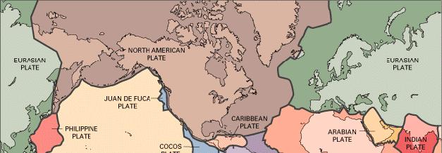


6 Major earthquakes are related to movements at Plate Boundaries 6 6
 (oceanic I/IhosptI&ra dastro,.ad) No map Iltect TCIP09\"'phy \101(:,\"1<:.alvity? RIdgelRif\,.. ''''''''.")
7 Three types of Plate Boundaries TYIM 01 M.rgin Diy.rgenl Conv.. gent Tr'IInatorm,_ Motion Sp-... SlIbductlon ulle.'.1 $Iiding --, Destruct... (oceanic Coo """'" lithosphere Cfeatlld) (oceanic I/IhosptI&ra dastro,.ad) No map Iltect TCIP09"'phy \101(:,"1<:.alvity? RIdgelRif\,.. ''''''''. Volcanic arc '0 Comeivative (lithosphere neilher created 0+' No

8 Tectonic Context of Canada s West Coast Convergence 8 8


9 NRCan Seismograph Network detects earthquakes in Canada High density of stations in eastern Canada 9
10 Canadian National Earthquake Catalogue Authoritative inventory of earthquake location, magnitude, depth, etc; Based on written historical accounts and instrument records; NRCan seismograph network can detect all earthquakes greater than M3.0 anywhere in Canadian territory; Near some populated areas, the denser station network allows us to detect earthquakes as small as M1.0; If the earthquake can be felt, we can record and measure it. 10

11 Record of M6+ earthquakes in Canada and smaller events that were notable Significant earthquakes of Canada ,
12 Earthquakes in eastern Canada Earthquakes that can be felt in eastern Canada are rare; They occur mainly in well-defined zones, characterized by many tens of small (<M3) earthquakes annually; Most earthquakes that have caused any damage have occurred in known seismically active zones; Most earthquakes occur at depths between 5 and 25 km, and represent reactivation of old faults deep in the Precambrian Basement; Only one earthquake is known to have ever caused a surface fault rupture (Ungava); Faults mapped at the surface are not necessarily seismically active; The Canadian National Earthquake Catalogue and our knowledge are the basis for Seismic Hazard Maps. 12
' ~ Atlalltic Oceall o o Canadian Earthquakes kno'hl to hive caused $OITl' damage o Magnitude 4.5 to 8.")
13 Earthquake Distribution of Eastern Canada Hudsol1 Btl)' o ~M' 8ank. 0 Zone 199,7.2) 0, 00 o 1935 t'.2)' ~ Atlalltic Oceall o o Canadian Earthquakes kno'hl to hive caused $OITl' damage o Magnitude 4.5 to 8.6 MagnlbJde 3.0 to 4.5
 Ottawa Montreal Toronto Increasing Hazard 14 Sa(0.")
14 Seismic Hazard Map Historical seismicity + Geological Model Québec Robuste Estimate of shaking that new buildings are required to withstand (under the National Building Code of Canada) Ottawa Montreal Toronto Increasing Hazard 14 Sa(0.2)

15 Map of all M5 and greater earthquakes recorded in the region (Jan Mar 2011) -- '... ~ * " {J ~/-./ ~.~'Z ~.Darllngton...- * km :, I' o 100' ~ oo Magnitude * * * ~ Natural Resources Ressources naturelles C,aIlada Canada Canada 15
16 Conclusions Large earthquakes (M8+) are expected near plate boundaries such as subduction zones; Eastern Canada is an "intraplate environment, well away from plate boundaries; Generally low-level of earthquakes in eastern Canada, but some well-defined zones are recognized as being more active (i.e. Charlevoix); Historically, most eastern Canada earthquakes occur in these well-defined zones, but have produced only minor damage; The region around Lake Ontario is one of low- to moderate seismicity, earthquakes in the Canadian Shield are even more rare; Historical observations and more recent continuous records of earthquake activity are used to develop seismic hazard maps that define the seismic provisions of 16 the National Building Code.
Earthquakes in Canada
 Earthquakes in Canada Maurice Lamontagne, Ph.D., ing. Geological Survey of Canada Natural Resources Canada 1 What is an Earthquake? P S P S P PS 2 2 Movement on a fault plane causes vibrations The larger
Earthquake. What is it? Can we predict it?
 Earthquake What is it? Can we predict it? What is an earthquake? Earthquake is the vibration (shaking) and/or displacement of the ground produced by the sudden release of energy. Rocks under stress accumulate
MAR110 Lecture #5 Plate Tectonics-Earthquakes
 1 MAR110 Lecture #5 Plate Tectonics-Earthquakes Figure 5.0 Plate Formation & Subduction Destruction The formation of the ocean crust from magma that is upwelled into a pair of spreading centers. Pairs
What is an earthquake?
 What is an earthquake? Shaking or vibration of the ground rocks undergoing deformation break suddenly along a fault 1906 San Francisco earthquake Oblique view of the San Andreas fault and San Francisco
Determining the Earthquake Epicenter: Japan
 Practice Name: Hour: Determining the Earthquake Epicenter: Japan Measuring the S-P interval There are hundreds of seismic data recording stations throughout the United States and the rest of the world.
Internal Layers of the Earth
 Lecture #4 notes Geology 3950, Spring 2006; CR Stern Seismic waves, earthquake magnitudes and location, and internal earth structure (pages 28-95 in the 4 th edition and 28-32 and 50-106 in the 5 th edition)
Earthquake Risk in Canada and the National Building Code
 Earthquake Risk in Canada and the National Building Code Tuna Onur, Ph.D. Onur Seemann Consulting, Inc. NICC, Vancouver, BC, 28-30 September 2016 Southwestern Canada: Cascadia Subduction Zone + Crustal
Lecture 4: Earthquakes and Seismic Waves
 Lecture 4: Earthquakes and Seismic Waves Key Questions 1. What are the sources for EQs in the PNW? 2. What is a seismograph and seismogram? 3. What is the difference between Richter magnitudes and Mercalli
Earthquakes and Seismic Waves Lesson 4 2
 Earthquakes and Seismic Waves Lesson 4 2 Apr 15 8:52 PM What are seismic waves? How are earthquakes measured? How is an earthquake located? Apr 15 8:54 PM 1 What are seismic waves An earthquake is the
Overview of National Seismic Hazard Maps for the next National Building Code
 Overview of National Seismic Hazard Maps for the next National Building Code John Adams Earthquakes Canada Geological Survey of Canada Copyright. Her Majesty the Queen in Right of Canada, 2004 CSCE Workshop
Magnitude 7.1 SOUTH SANDWICH ISLANDS
 A magnitude 7.1 earthquake occurred at a depth of 164.7 km (102 miles) in the South Sandwich Islands, an uninhabited British territory off the coast of Argentina in the southern Atlantic Ocean. Antarctica
12.2 Plate Tectonics
 12.2 Plate Tectonics LAYERS OF THE EARTH Earth is over 1200 km thick and has four distinct layers. These layers are the crust, mantle (upper and lower), outer core, and inner core. Crust outer solid rock
Elastic Rebound Theory
 Earthquakes Elastic Rebound Theory Earthquakes occur when strain exceeds the strength of the rock and the rock fractures. The arrival of earthquakes waves is recorded by a seismograph. The amplitude of
An Earthquake is a rapid vibration or shaking of the Earth s crust created by a release in energy from sudden movement of a part of a plate along a
 An Earthquake is a rapid vibration or shaking of the Earth s crust created by a release in energy from sudden movement of a part of a plate along a fault. Energy released radiates in all directions from
21. Earthquakes I (p ; 306)
") 21. Earthquakes I (p. 296-303; 306) How many people have been killed by earthquakes in the last 4,000 years? How many people have been killed by earthquakes in the past century? What two recent earthquakes
21. Earthquakes I (p. 296-303; 306) How many people have been killed by earthquakes in the last 4,000 years? How many people have been killed by earthquakes in the past century? What two recent earthquakes
Earthquakes. Forces Within Eartth. Faults form when the forces acting on rock exceed the rock s strength.
 Earthquakes Vocabulary: Stress Strain Elastic Deformation Plastic Deformation Fault Seismic Wave Primary Wave Secondary Wave Focus Epicenter Define stress and strain as they apply to rocks. Distinguish
Features of Tectonic Plates
 Features of Tectonic Plates PowerPoint 12.2 The Earth s Layers Crust Brittle Continental crust composed mainly of granite Oceanic crust composed mainly of basalt Mantle Denser than the crust Upper is molten
20.1 Earthquakes. Chapter 20 EARTHQUAKES AND VOLCANOES. Earthquakes and plate boundaries 500 UNIT 6 EARTH S STRUCTURE
 Chapter 20 EARTHQUAKES AND VOLCANOES 20.1 Earthquakes In Chapter 19, you read about the San Andreas Fault, which lies along the California coast (Figure 20.1). This fault passes right through San Francisco
Engineering Characteristics of Ground Motion Records of the Val-des-Bois, Quebec, Earthquake of June 23, 2010
 CSCE 2011 General Conference - Congrès générale 2011 de la SCGC Ottawa, Ontario June 14-17, 2011 / 14 au 17 juin 2011 Engineering Characteristics of Ground Motion Records of the Val-des-Bois, Quebec, Earthquake
Magnitude 8.3 SEA OF OKHOTSK
 A powerful earthquake in Russia's Far East was felt as far away as Moscow, about 7,000 kilometers (4,400 miles) west of the epicenter, but no casualties or damage were reported. The epicenter was in the
Earthquakes Earth, 9th edition, Chapter 11 Key Concepts What is an earthquake? Earthquake focus and epicenter What is an earthquake?
 1 2 3 4 5 6 7 8 9 10 Earthquakes Earth, 9 th edition, Chapter 11 Key Concepts Earthquake basics. "" and locating earthquakes.. Destruction resulting from earthquakes. Predicting earthquakes. Earthquakes
Earthquakes and Earthquake Hazards Earth - Chapter 11 Stan Hatfield Southwestern Illinois College
 Earthquakes and Earthquake Hazards Earth - Chapter 11 Stan Hatfield Southwestern Illinois College What Is an Earthquake? An earthquake is the vibration of Earth, produced by the rapid release of energy.
Advanced Workshop on Evaluating, Monitoring and Communicating Volcanic and Seismic Hazards in East Africa.
 2053-8 Advanced Workshop on Evaluating, Monitoring and Communicating Volcanic and Seismic Hazards in East Africa 17-28 August 2009 Seismicity of the East African Rift Atalay Ayele W. Addis Ababa University
Magnitude 7.1 NEAR THE EAST COAST OF HONSHU, JAPAN
 Japan was rattled by a strong aftershock and tsunami warning Thursday night nearly a month after a devastating earthquake and tsunami flattened the northeastern coast. This earthquake can be considered
Earthquakes Chapter 19
 Earthquakes Chapter 19 Does not contain complete lecture notes. What is an earthquake An earthquake is the vibration of Earth produced by the rapid release of energy Energy released radiates in all directions
Earth and Space Science Semester 2 Exam Review. Part 1. - Convection currents circulate in the Asthenosphere located in the Upper Mantle.
 Earth and Space Science 2015 Semester 2 Exam Review Part 1 Convection -A form of heat transfer. - Convection currents circulate in the Asthenosphere located in the Upper Mantle. - Source of heat is from
Mw 7.8, Southwest of Sumatra, Indonesia Wed, 2 March 2016 at 12:49:48 UTC M /03/03
 Earthquake overview AFGHANISTA N PAKISTA N INDIA A moment magnitude (Mw) 7.8 earthquake struck in South West, Indonesia. The epicentre was centered about 800 km West South West of Padang, Sumatra province,
The AIR Earthquake Model for Canada
 The AIR Earthquake Model for Canada Canada experienced one of the most powerful earthquakes in world history when an M9.0 event struck just offshore of western North America in 1700. If a similar earthquake
What is an Earthquake?
 Earthquakes What is an Earthquake? Earthquake - sometimes violent shaking of ground caused by movement of Earth s tectonic plates; creates seismic waves Often followed by smaller earthquakes (aftershocks);
Earthquakes. Building Earth s Surface, Part 2. Science 330 Summer What is an earthquake?
 Earthquakes Building Earth s Surface, Part 2 Science 330 Summer 2005 What is an earthquake? An earthquake is the vibration of Earth produced by the rapid release of energy Energy released radiates in all
Dangerous tsunami threat off U.S. West Coast
 Earthquakes Ch. 12 Dangerous tsunami threat off U.S. West Coast Earthquakes What is an Earthquake? It s the shaking and trembling of the Earth s crust due to plate movement. The plates move, rocks along
Multi-station Seismograph Network
 Multi-station Seismograph Network Background page to accompany the animations on the website: IRIS Animations Introduction One seismic station can give information about how far away the earthquake occurred,
Plate Tectonics Comic Book Pg s 9-13
 Plate Tectonics Comic Book Pg s 9-13 Your Comic Book should include the following on each page: Your CHARACTER thoroughly explaining the concept for the page DRAWINGS for each of the topics A brief EXPLANATION
Chapter 15. Earthquakes and Plate Tectonics. what s the connection? At the boundaries friction causes plates to stick together.
 Chapter 15 Earthquakes and Plate Tectonics what s the connection? As with volcanoes, earthquakes are not randomly distributed over the globe At the boundaries friction causes plates to stick together.
Lecture Outline Wednesday-Monday April 18 23, 2018
 Lecture Outline Wednesday-Monday April 18 23, 2018 Questions? Lecture Final Exam Lecture Section 1 Friday May 4, 8:00-10:00am Lecture Section 2 Friday May 4, 3:10-5:10 pm Final Exam is 70% new material
Part 2 - Engineering Characterization of Earthquakes and Seismic Hazard. Earthquake Environment
 Part 2 - Engineering Characterization of Earthquakes and Seismic Hazard Ultimately what we want is a seismic intensity measure that will allow us to quantify effect of an earthquake on a structure. S a
Magnitude 7.6 & 7.6 PERU
 Two deep 7.6 magnitude earthquakes have shaken a sparsely populated jungle region near the Peru-Brazil border in southeast Peru. There were no immediate reports of injuries or damage. The second M 7.6
I. INTRODUCTION II. EARTHQUAKES
 2018 IJSRST Volume 4 Issue 5 Print ISSN: 2395-6011 Online ISSN: 2395-602X Themed Section: Science and Technology Iraq Earthquake Contour Maps Bashair A.R. Mohammed *1, Israa H. Mohammed 2, Tariq N. Ataiwe
5. What is an earthquake 6. Indicate the approximate radius of the earth, inner core, and outer core.
 Tutorial Problems 1. Where Do Earthquakes Happen? 2. Where do over 90% of earthquakes occur? 3. Why Do Earthquakes Happen? 4. What are the formulae for P and S velocity 5. What is an earthquake 6. Indicate
Magnitude 7.0 PERU. This region of the Andes is a sparsely populated area, there were no immediate reports of injuries or damage.
 A magnitude 7.0 earthquake occurred in southeastern Peru on Friday about 27 kilometers northeast of the town of Azángaro, Peru, near the border with Bolivia. The earthquake occurred at a depth of 257.4
UNIT - 7 EARTHQUAKES
 UNIT - 7 EARTHQUAKES WHAT IS AN EARTHQUAKE An earthquake is a sudden motion or trembling of the Earth caused by the abrupt release of energy that is stored in rocks. Modern geologists know that most earthquakes
Magnitude 7.5 PALU, INDONESIA
 A magnitude 7.5 earthquake occurred 80.8 km (50.2 mi) north of Palu, Indonesia at a depth of 10 km (6.2 miles). This earthquake triggered a tsunami with wave heights up to 2 m (6.6 ft) that an official
Module 7: Plate Tectonics and Earth's Structure Topic 4 Content : Earthquakes Presentation Notes. Earthquakes
 Earthquakes 1 Topic 4 Content: Earthquakes Presentation Notes Earthquakes are vibrations within the Earth produced by the rapid release of energy from rocks that break under extreme stress. Earthquakes
Magnitude Area Scaling of SCR Earthquakes. Summary
 Magnitude Area Scaling of SCR Earthquakes Paul Somerville Summary Review of Existing Models Description of New Model Comparison of New and Existing Models Existing Models Allman & Shearer, 2009 Global,
Section Forces Within Earth. 8 th Grade Earth & Space Science - Class Notes
 Section 19.1 - Forces Within Earth 8 th Grade Earth & Space Science - Class Notes Stress and Strain Stress - is the total force acting on crustal rocks per unit of area (cause) Strain deformation of materials
GEOLOGY MEDIA SUITE Chapter 13
 UNDERSTANDING EARTH, SIXTH EDITION GROTZINGER JORDAN GEOLOGY MEDIA SUITE Chapter 13 Earthquakes 2010 W.H. Freeman and Company Three different types of seismic waves are recorded by seismographs Key Figure
MAR110 LECTURE #6 West Coast Earthquakes & Hot Spots
 17 September 2007 Lecture 6 West Coast Earthquakes & Hot Spots 1 MAR110 LECTURE #6 West Coast Earthquakes & Hot Spots Figure 6.1 Plate Formation & Subduction Destruction The formation of the ocean crust
SEISMOLOGY. - The study of earthquakes waves and how they move through the body and around the surface of the earth.
 EARTHQUAKES SEISMOLOGY - The study of earthquakes waves and how they move through the body and around the surface of the earth. Seismic Waves - vibrations generated in the earths interior that carry energy
Figure Diagram of earth movements produced by (a) P-waves and (b) S-waves.
 P-waves and (b) S-waves.") Geology 101 Name(s): Lab 10: Earthquakes When the stresses in a rock (which may or may not already be faulted) exceed the tensile strength of the rock, the rock ruptures at a point called the focus or
Geology 101 Name(s): Lab 10: Earthquakes When the stresses in a rock (which may or may not already be faulted) exceed the tensile strength of the rock, the rock ruptures at a point called the focus or
22.5 Earthquakes. The tsunami triggered by the 2004 Sumatra earthquake caused extensive damage to coastal areas in Southeast Asia.
 The tsunami triggered by the 2004 Sumatra earthquake caused extensive damage to coastal areas in Southeast Asia. An earthquake is a movement of Earth s lithosphere that occurs when rocks in the lithosphere
Magnitude 7.0 PAPUA, INDONESIA
 A 7.0 magnitude earthquake struck eastern Indonesia's mountainous West Papua province on Saturday but there were no immediate reports of casualties or damage. The region is sparsely populated. According
Physical Geology Lab. Teacher Check (show your screen to your teacher) Part ONE: Dynamic Earth. Continents Over Time.
 Part ONE: Dynamic Earth. Continents Over Time.") Physical Geology Lab Name Hour Part ONE: Dynamic Earth Earth s Structure Name the Layer: The only liquid layer Only a few miles thick (under oceans) Mostly solid iron and nickel Made of hot, semi-solid
Physical Geology Lab Name Hour Part ONE: Dynamic Earth Earth s Structure Name the Layer: The only liquid layer Only a few miles thick (under oceans) Mostly solid iron and nickel Made of hot, semi-solid
log 4 0.7m log m Seismic Analysis of Structures by TK Dutta, Civil Department, IIT Delhi, New Delhi. Module 1 Seismology Exercise Problems :
 Seismic Analysis of Structures by TK Dutta, Civil Department, IIT Delhi, New Delhi. Module Seismology Exercise Problems :.4. Estimate the probabilities of surface rupture length, rupture area and maximum
Plate Tectonics and Earth s Structure
 Plate Tectonics and Earth s Structure Chapter Eight: Plate Tectonics Chapter Nine: Earthquakes Chapter Ten: Volcanoes Chapter Nine: Earthquakes 9.1 What is an Earthquake? 9.2 Seismic Waves 9.3 Measuring
Chapter Introduction Lesson 1 Earthquakes Lesson 2 Volcanoes Chapter Wrap-Up
 Chapter Introduction Lesson 1 Earthquakes Lesson 2 Volcanoes Chapter Wrap-Up What causes earthquakes and volcanic eruptions? What do you think? Before you begin, decide if you agree or disagree with each
Finding an Earthquake Epicenter Pearson Education, Inc.
 Finding an Earthquake Epicenter Measuring the Size of Earthquakes Two measurements that describe the size of an earthquake are: 1. Intensity a measure of the degree of earthquake shaking at a given locale
INTRODUCTION TO EARTHQUAKES
 INTRODUCTION TO EARTHQUAKES Seismology = Study of earthquakes Seismologists = Scientists who study earthquakes Earthquake = Trembling or shaking of the earth s surface, usually as a result of the movement
Earthquakes & Volcanoes
 Earthquakes & Volcanoes Geology - the study of solid Earth, the rocks of which it is composed, and the processes by which they change geo = Earth; ology = study of Earth s Layers Plate Tectonics - the
Magnitude 6.3 SOUTH ISLAND OF NEW ZEALAND
 A magnitude 6.3 earthquake shook the southern New Zealand city of Christchurch. At least 100 people are reported dead, and there are reports of collapsed buildings, cracked streets and flooding due to
Earthquakes and Earth s Chapter. Interior
 Earthquakes and Earth s Chapter Interior 8.1 What Is an Earthquake? An earthquake is the vibration of Earth produced by the rapid release of energy Focus and Epicenter Focus is the point within Earth
Activity Pacific Northwest Tectonic Block Model
 Activity Pacific Northwest Tectonic Block Model The Cascadia tectonic margin is caught between several tectonic forces, during the relentless motions of the giant Pacific Plate, the smaller subducting
Beneath our Feet: The 4 Layers of the Earty by Kelly Hashway
 Beneath our Feet: The 4 Layers of the Earty by Kelly Hashway The Earth is more than a giant ball made up of dirt, rocks, and minerals. The Earth may look like a giant ball from when looking at it from
Earth Movement and Resultant Landforms
 Earth Movement and Resultant Landforms Structure of the Earth Lithosphere : earth s crust Asthenosphere : upper mantle zone where material is near its melting point & acts almost like liquid (appprox.
Once you have opened the website with the link provided choose a force: Earthquakes
 Name: Once you have opened the website with the link provided choose a force: Earthquakes When do earthquakes happen? On the upper left menu, choose number 1. Read What is an Earthquake? Earthquakes happen
Cascadia Seismic Event Planning for the Maritime Community
 Cascadia Seismic Event Planning for the Maritime Community Jonathan Allan, Oregon Dept. of Geology and Mineral Industries Presentation to Annual Pacific Northwest Waterways Association Meeting (PNWA) October
1. I can describe evidence for continental drift theory (e.g., fossil evidence, mountain belts, paleoglaciation)
") Science 10 Review Earth Science Vocabulary asthenosphere continental drift theory converging plates diverging plates earthquakes epicentre fault hot spot inner core lithosphere mantle mantle convection
Science 10 Review Earth Science Vocabulary asthenosphere continental drift theory converging plates diverging plates earthquakes epicentre fault hot spot inner core lithosphere mantle mantle convection
PLATE TECTONIC PROCESSES
 Lab 9 Name Sec PLATE TECTONIC PROCESSES 1. Fill in the blank spaces on the chart with the correct answers. Refer to figures 2.3, 2.4 p.33 (2.2 and 2.3 on p. 23) as needed. 2. With your knowledge of different
Section 19.1: Forces Within Earth Section 19.2: Seismic Waves and Earth s Interior Section 19.3: Measuring and Locating.
 CH Earthquakes Section 19.1: Forces Within Earth Section 19.2: Seismic Waves and Earth s Interior Section 19.3: Measuring and Locating Earthquakes Section 19.4: Earthquakes and Society Section 19.1 Forces
NAME HOMEWORK ASSIGNMENT #4 MATERIAL COVERS CHAPTERS 19, 20, 21, & 2
 NAME HOMEWORK ASSIGNMENT #4 MATERIAL COVERS CHAPTERS 19, 20, 21, & 2 Assignment is due the beginning of the class period on December 14, 2004. Mark answers on a scantron sheet, which will be provided.
Earthquakes.
 Earthquakes http://quake.usgs.gov/recenteqs/latestfault.htm An earthquake is a sudden motion or shaking of the Earth's crust, caused by the abrupt release of stored energy in the rocks beneath the surface.
Objectives. Vocabulary
 Forces Within Earth Objectives Define stress and strain as they apply to rocks. Distinguish among the three types of faults. Contrast three types of seismic waves. Vocabulary stress strain fault primary
Magnitude 7.7 QUEEN CHARLOTTE ISLANDS REGION
 A major 7.7 magnitude earthquake struck at 8:04 PM local time in western British Columbia, Canada. The epicenter is located on Moresby Island, the southern large island in the Queen Charlotte Islands region.
Name Class Date. 1. What is the outermost layer of the Earth called?. a. core b. lithosphere c. asthenosphere d. mesosphere
 Name Class Date Assessment Geology Plate Tectonics MULTIPLE CHOICE Write the letter of the correct answer in the space provided. 1. What is the outermost layer of the Earth called?. a. core b. lithosphere
Learning Objectives (LO)! Lecture 11: Plate Tectonics II! No Homework!! ** Chapter 3 **! What we ll learn today:!
! Lecture 11: Plate Tectonics II! No Homework!! ** Chapter 3 **! What we ll learn today:!") Learning Objectives (LO)! Lecture 11: Plate Tectonics II! No Homework!! ** Chapter 3 **! What we ll learn today:! 1. List the three types of tectonic plate boundaries! 2. Describe the processes occurring
Learning Objectives (LO)! Lecture 11: Plate Tectonics II! No Homework!! ** Chapter 3 **! What we ll learn today:! 1. List the three types of tectonic plate boundaries! 2. Describe the processes occurring
Name Date Period. Directions: Complete this table by writing each sentence under the correct heading.
 pgs 211-220 Content Practice A Directions: Complete this table by writing each sentence under the correct heading. Surface waves travel more slowly than other waves. Risk assessments help engineers design
Knowledge of in-slab earthquakes needed to improve seismic hazard estimates for southwestern British Columbia
 USGS OPEN FILE REPORT #: Intraslab Earthquakes 1 Knowledge of in-slab earthquakes needed to improve seismic hazard estimates for southwestern British Columbia John Adams and Stephen Halchuk Geological
Earthquake Hazards. Tsunami
 Earthquake Hazards Tsunami Measuring Earthquakes Two measurements that describe the power or strength of an earthquake are: Intensity a measure of the degree of earthquake shaking at a given locale based
Ground-motion and Intensity: were the Basel 2006 and St. Gallen 2013 Events Fundamentally Different?
 Ground-motion and Intensity: were the Basel 2006 and St. Gallen 2013 Events Fundamentally Different? Benjamin Edwards 1,2, Toni Kraft 1, Carlo Cauzzi 1, Philipp Kästli 1 and Stefan Wiemer 1 1 Swiss Seismological
Magnitude 7.5 NEW BRITAIN REGION, PAPUA NEW GUINEA
 A magnitude 7.5 earthquake struck off the eastern coast of Papua New Guinea on Tuesday, approximately 130 km (81 mi) southsouthwest of Kokopo at a depth of 42 km (26.1 mi). There are reports of some structural
Lithospheric plates. Geology of the Batemans Bay region. Tectonic processes
 1 Lithospheric plates Enormous heat sources in the Earth s deep interior, acquired during the very early history of the planet billions of years ago continue to drive present-day geological at the surface.
S e i s m i c W a v e s
 Project Report S e i s m i c W a v e s PORTLAND STATE UNIVERSITY PHYSICS 213 SPRING TERM 2005 Instructor: Dr. Andres La Rosa Student Name: Prisciliano Peralta-Ramirez Table Of Contents 1. Cover Sheet 2.
Hazard and Vulnerability of Moderate Seismicity Regions
 Hazard and Vulnerability of Moderate Seismicity Regions presented by Professor Tso-Chien PAN Dean, College of Engineering Director, 25 October 2010 DRM GDLN Session on Earthquake Vulnerability Reduction
Earthquakes Modified
 Plate Tectonics Earthquakes Modified Recall that the earth s crust is broken into large pieces called. These slowly moving plates each other, each other, or from each other. This causes much on the rocks.
Historical Maximum Seismic Intensity Maps in Japan from 1586 to 2004: Construction of Database and Application. Masatoshi MIYAZAWA* and Jim MORI
 Annuals of Disas. Prev. Res. Inst., Kyoto Univ., No. 4C, 25 Historical Maximum Seismic Intensity Maps in Japan from 6 to 24: Construction of Database and Application Masatoshi MIYAZAWA* and Jim MORI *
Magnitude 6.9 GULF OF CALIFORNIA
 A pair of strong earthquakes struck off the coast of Mexico early Thursday only minutes apart. The magnitude 6.9 and 6.2 were centered about 85 miles northeast of Guerrero Negro in the Mexican state of
Moho (Mohorovicic discontinuity) - boundary between crust and mantle
 - boundary between crust and mantle") Earth Layers Dynamic Crust Unit Notes Continental crust is thicker than oceanic crust Continental Crust Thicker Less Dense Made of Granite Oceanic Crust Thinner More Dense Made of Basalt Moho (Mohorovicic
Earth Layers Dynamic Crust Unit Notes Continental crust is thicker than oceanic crust Continental Crust Thicker Less Dense Made of Granite Oceanic Crust Thinner More Dense Made of Basalt Moho (Mohorovicic
focus seismic waves Earthquakes
 LESSON 3 fault line All of a sudden, Earth s crust shakes and solid land shifts. What causes an earthquake? How can an earthquake be measured? Read this selection to learn about earthquakes. Earthquakes
What scientists know and do not know about the big one at Cascadia
 What scientists know and do not know about the big one at Cascadia Kelin Wang Pacific Geoscience Centre, Geological Survey of Canada Natural Resources Canada The Cascadia Subduction Zone M 7.3, 1946 Rupture
Earthquakes. Dr. Mark van der Meijde INTERNATIONAL INSTITUTE FOR GEO-INFORMATION SCIENCE AND EARTH OBSERVATION
 Earthquakes Dr. Mark van der Meijde vandermeijde@itc.nl INTERNATIONAL INSTITUTE FOR GEO-INFORMATION SCIENCE AND EARTH OBSERVATION Topics to handle Theory of earthquakes Mechanism Strength Measurements
Magnitude 7.9 SE of KODIAK, ALASKA
 A magnitude 7.9 earthquake occurred at 12:31 am local time 181 miles southeast of Kodiak at a depth of 25 km (15.5 miles). There are no immediate reports of damage or fatalities. Light shaking from this
Magnitude 7.0 NEW CALEDONIA
 A magnitude 7.0 earthquake has occurred 82km ENE of Maré Island, the secondlargest of the Loyalty Islands in the archipelago of New Caledonia. The initial report of the magnitude and shallow 10km depth
Three Fs of earthquakes: forces, faults, and friction. Slow accumulation and rapid release of elastic energy.
 Earthquake Machine Stick-slip: Elastic Rebound Theory Jerky motions on faults produce EQs Three Fs of earthquakes: forces, faults, and friction. Slow accumulation and rapid release of elastic energy. Three
Earthquakes!! Be sure to fill in your notes sheet as you go through the power point!
 Earthquakes!! Be sure to fill in your notes sheet as you go through the power point! Plate Boundary Review Click on the link below to try some plate boundary movement simulations. The link will take you
Preview Mode: ON Earthquake Risk in Stable, Intraplate Regions: the Case. of Perth, Australia. Historical Seismicity in the Perth Region
 Preview Mode: ON Earthquake Risk in Stable, Intraplate Regions: the Case Editor s note: There is often a tendency to discount earthquake risk in of Perth, Australia 02.2010 AIRCurrents regions where earthquakes
Tectonic Processes and Hazards Enquiry Question 1: Why are some locations more at risk from tectonic hazards?
 Tectonic Processes and Hazards Enquiry Question 1: Why are some locations more at risk from tectonic hazards? Key words Basalt Andesite Rhyolite Benioff Zone Subduction zone Crustal fracturing Definition
Chapter 13 Earthquakes and Earth s Interior
 Chapter 13 Earthquakes and Earth s Interior The crust of the Earth is made up of floating tectonic plates- huge continent-sized chunks of solid rock floating on molten rock. Rock masses along the boundaries
Earthquakes 11/14/2014. Earthquakes Occur at All Boundaries. Earthquakes. Key Aspects of an Earthquake. Epicenter. Focus
 Earthquakes Earthquakes Caused by friction and movement between Earth s tectonic plates A release of force Often caused by a catch between two plates As plates slide by, they stick to each other When the
The Mechanics of Earthquakes and Faulting
 The Mechanics of Earthquakes and Faulting Christopher H. Scholz Lamont-Doherty Geological Observatory and Department of Earth and Environmental Sciences, Columbia University 2nd edition CAMBRIDGE UNIVERSITY
A magnitude 7.8 earthquake has occurred km (63.3 mi) ESE of Suva, Fiji at a depth of km (378 miles).
 ESE of Suva, Fiji at a depth of km (378 miles).") A magnitude 7.8 earthquake has occurred 101.8 km (63.3 mi) ESE of Suva, Fiji at a depth of 608.6 km (378 miles). There is no risk of a tsunami from an earthquake at this depth. Images courtesy of Google
A magnitude 7.8 earthquake has occurred 101.8 km (63.3 mi) ESE of Suva, Fiji at a depth of 608.6 km (378 miles). There is no risk of a tsunami from an earthquake at this depth. Images courtesy of Google
Magnitude 8.2 FIJI. A magnitude 8.2 earthquake occurred km (226.7 mi) E of Suva, Fiji at a depth of km (350 miles).
 E of Suva, Fiji at a depth of km (350 miles).") A magnitude 8.2 earthquake occurred 364.8 km (226.7 mi) E of Suva, Fiji at a depth of 563.4 km (350 miles). There is no risk of a tsunami from an earthquake at this depth. Images courtesy of Google The
A magnitude 8.2 earthquake occurred 364.8 km (226.7 mi) E of Suva, Fiji at a depth of 563.4 km (350 miles). There is no risk of a tsunami from an earthquake at this depth. Images courtesy of Google The