Management System For Natural Risk Disaster On Infrastructure: Regional Approach (GRDR)
|
|
|
- Giles Jacobs
- 6 years ago
- Views:
Transcription
1 Management System For Natural Risk Disaster On Infrastructure: Regional Approach (GRDR) Matías Valenzuela Saavedra Associate Professor at Pontificia Universidad Catolica de Valparaiso, Civil Eng, PhD 27 April 2017
2 Latin American disasters Structural damage in Chile GRD and GRDR Method: Description and Application Start up South Chile Final comments
3 Latin American Disasters
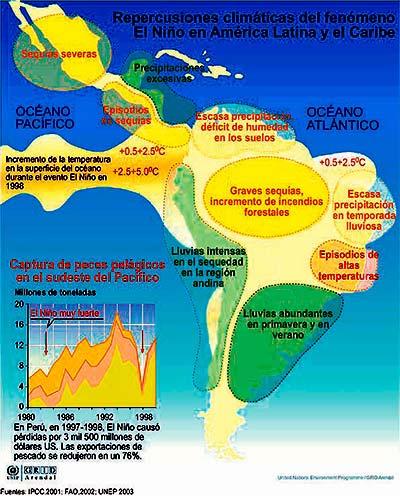
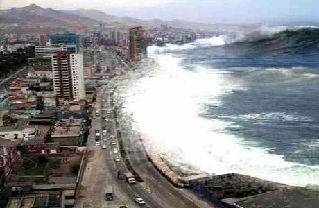
4 Backgrounds Latin America has been exposed, in recent times, various types of natural disasters including earthquakes, fires, volcanic activity, landslides, mud, among others. This condition requires the development of methods for identification of hazards, simulation / modeling Stava-1985 of likely scenarios, Mochikoshi-1978 impacts on society and control measures and mitigation (Italia) (Japón) Earthquake Landslides La ligua-1965 Avalanches Chile Bafokeng-1974 (Sudáfrica) Volcano Floods

5 Regional Hazards
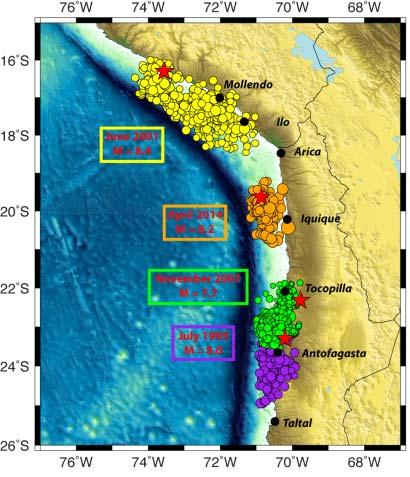
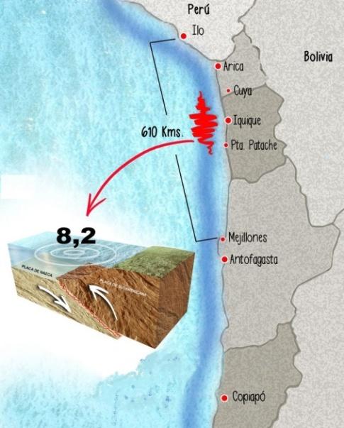
6 2010 Haiti Earthquake (12 January 2010) Epicenter 15 km from Port au Prince, Haiti's capital. 7.2 magnitude Died 316,000 people. Tsunami minor Deaths: 4 people. LATAM Disasters This earthquake was the strongest recorded in the area since The earthquake occurred in was felt in nearby countries such as Cuba, Jamaica and the Dominican Republic, where it caused fear and preventive evacuations. Chile Earthquake + Tsunami 2010 February 27, 2010, Magnitude 8.8 Epicenter in the Chilean Sea, opposite the towns of Curanipe Died 264 People It was felt in much of the Southern Cone with varying intensities, (Buenos Aires and São Paulo)
7 LATAM Disasters Guatemala Earthquake February 4, 1976 Magnitude of 7.5 degrees on the Richter scale Epicenter 5 kilometers 160 kilometers northeast of the capital Guatemala City 23,000 died In just a few seconds one third of the capital was reduced to debris and thousands of buildings collapsed Valdivia Earthquake Great Chilean Earthquake May 22, 1960 Epicenter Araucanía Region Magnitude 9.5 (10 minutes) Series of tsunamis 2,000 people dead. Greater magnitude earthquake recorded
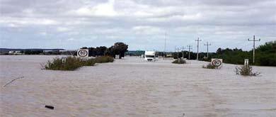
8 Flood Rio de Janeiro Year 2010 Died 100 person. Most victims have been buried by landslides in favelas built on hillsides. LATAM Disasters Flood Mexico October 28 to December 15, 2007 Mexican states of Tabasco and Chiapas Peak floods of rivers Since the last rescue, and water extraction, delay of one month Eruption of Nevado del Ruiz volcano November 13, 1985 Department of Tolima, Colombia. Story of Omaira Sanchez. Importance of prevention systems, emergency support
9 Hazards and Structural Damage in Chile


10 Landslide Country CHILE Place Atacama Year 2015 Causes Heavy rainfall Main consequences Infrastructure destruction Deaths Contamination


11 VOLCANOES Country CHILE Location Los Ríos Y Araucanía Year 2015 Causes Volcanic eruption Main consequences Destruction of infrastructure Casualties Contamination

12 11th International Bridge and EFECTOS DEL TERREMOTO Structure Management Conference 27F Mesa Arizona, USA. Gobierno de Chile Ministerio de Obras Públicas

13 Gobierno de Chile Ministerio de Obras Públicas 11th International Bridge and

14 CARAHUE COLAPSO - NEHUENTUE DE RUTA PUENTE P22 Gobierno de Chile Ministerio de Obras Públicas

15 Gobierno de Chile Ministerio de Obras Públicas COLAPSO PUENTE DE RUTA PUENTE LLACOLÉN P22 RUTA 160 KM 32

16 COLAPSO DE PUENTE Gobierno de Chile Ministerio de Obras Públicas
17 Hazards and Structural Damage in Chile Last three month!!!


18 Country CHILE Location Quellon - Chiloe Year 25 December 2016 Causes Eartquake 7,6 Mw Main consequences Road and Bridge Collapse Social and economic issues


19 Country CHILE Location Petrohue Route Ch 225 Year 7 January 2017 Causes Rain fall Landslands Main consequences Road Collapse Isolation of 100 persons

 7154 Casualties 596.")
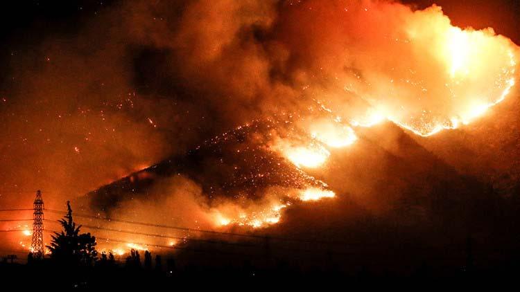
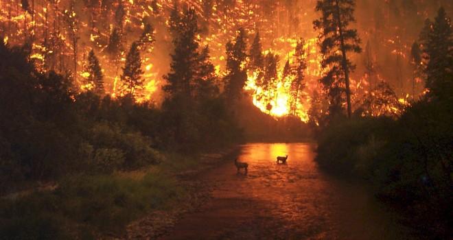
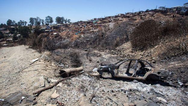
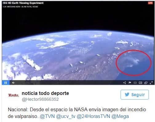
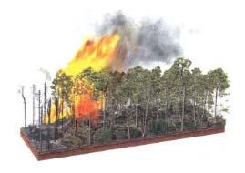
20 Country CHILE Location Centralof Chile 800 km Year Decemeber 2016 Causes Forrest Fires Main consequences Destruction of infrastructure (santa Olga town) 7154 Casualties HA Native Forrest burnt 11 death
21
22
23 Risk Management in LATAM and the Caribbean
24 LATAM System Natural Events = Disaster Towns in the path of damage, Incorrectly prepared structures (casual loadings). Institutions Objective Protect people and their property. Policies disaster risk management A national system for responding to disasters Financial mechanisms Rules
25 Pre-Disaster Integral Disaster Risk Management Determination of the hazard Mitigation Risk transference Preparation Hazard Assessment Vulnerability Analysis Risk analysis Hazard monitoring and forecasting Structural mitigation Soil and building standards Investment Education & Training Insurance and economic aspects Early warning system Contingency planning Agents response Refuge and evacuation Post-Disaster Emergency Response Reconstruction Humanitarian aid Cleaning and repair Damage assessment Resource mobilization Critical Infrastructure Reconstruction Budget and Macroeconomics Reactivation affected areas Structural elements mitigation Source: BID año 2000
26 Disaster management systems in Latin America and the Caribbean Government agencies to respond to emergencies Argentina Brasil Chile Colombia República Dominicana El Salvador Nicaragua Guatemala Honduras México Reconstruction and rehabilitation. Prevention Integral Systems Mitigation Civil Defense Ecuador Perú Venezuela Entities Coordination Center for Natural Disaster Prevention in Central America (1988). English-speaker Caribbean CDERA South America: Andean Development Corporation Preparation
27 GRD and GRDR Methods: Description and Application
28 Assessment Method Deterministic Probabilistic General Case (less data) Short-term preventive action Prior knowledge structural performance Data specific case Long-term action Study using optimization algorithm Study of performance characteristics (instrumentation) The Probabilistic Risk Assessment (CAPRA) Program RiskAssessment Flood Hurricane Landslide Seismic Tsunami Volcano Vulnerability
29 The structures have been subjected to different types of operational and accidental loads. With climate change these structures have been subjected to hazards which were not anticipated in its design. The deterministic method is intended to predict the damage of a structure under different types of hazards and prevent future damage. The deterministic method is updated by inspections using local technical groups = Alerts.
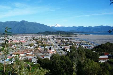
30 COSIPLAN IIRSA Method. Management of Risk Hazard on Infrastructure (G.R.D) There are problems with the management of infrastructure at Central Level Higher Cost Less knowledge and understanding of the needs of citizens Few knowledge of structures at each sector
31 The application of this method includes 2 stages and 4 phases: Stage A Stage B Phase 1: Identification of the element with pathologies materials under operating loads. Implementation of Probabilistic method Phase 2: Analyze pathologies but from the concept of the overall structure under operating loads. Mitigation measures Phase 3: The overall structure is analyzed, in addition to the pathologies, the loads generated by extreme events such as earthquakes or tsunamis are added. Phase 4: The structure is analyzed against extreme combinations of forces (earthquake and tsunami).
 Non Central Methodology Manager and inspection risk team of Central Level Transfer knowledge to regional teams Infrastructure management")
32 Chilean Proposal for Risk Management on infrastructure. Regional actions (G.R.D.R in Spanish) Non Central Methodology Manager and inspection risk team of Central Level Transfer knowledge to regional teams Infrastructure management at Regional Level, until certain value of vulnerability of each structures

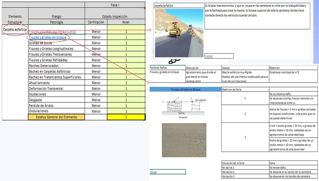
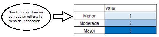
33 Phase 1 Element Pathologies Services Loads. Damage index - Material.
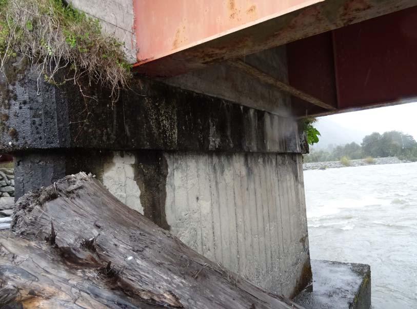
34

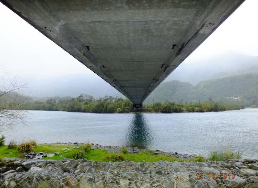
35 Phase 3 11th International Bridge and

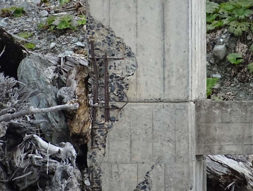
36 GRDR Method: Start up South of Chile Master Degree Program of Construction and Management Student: Rafael Romo Contreras Date: October 2016

37 Start up Program - Route 7


38 Country CHILE Chaiten City Location Chaiten Access to Patagonia Year May 2008 Causes Volcano Chaiten Volcano Main consequences Road and bridge collapse Destroy of Chaiten city 4000 Casualties Disrupt water and electrical service

")
 Roads")
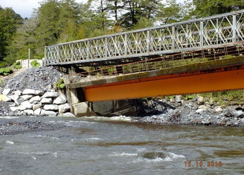
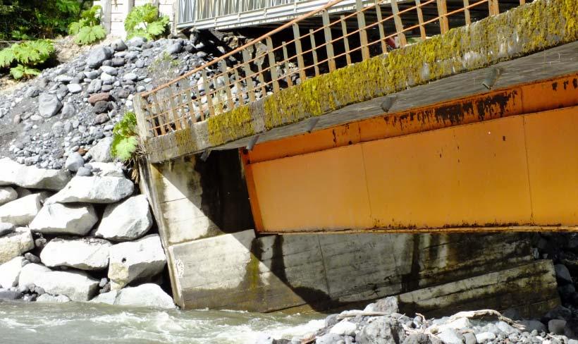
39 Inspections: (2) Suspension Bridge (1) Cable stay Bridge (5) Traditional Bridge (200 km) Roads Landslide areas
 Analyze the weather and potential hazards Prepare inspection sheets (phase 1,2 and 3) Simbologia Zona Volcanica Presenta Alto Peligro")
40 In office analysis: 11th International Bridge and Structure Planning Inspection: Contact and information of regional emergency entities and navy police to provide support during inspection Gathering information of structures (previous inspections and drawings) Analyze the weather and potential hazards Prepare inspection sheets (phase 1,2 and 3) Simbologia Zona Volcanica Presenta Alto Peligro Zona Volcanica Presenta Moderado Peligro Zona Volcanica Presenta Bajo Peligro Zona Volcanica "Área susceptible de ser afectada por Peligros Volcánicos" Tsunami: Se encuentra en Área de Evacuación Tsunami: Se encuentra bajo Cota 30 Monography Incendio Forestal: Densidad Baja Camino Asfaltico Camino de Ripio


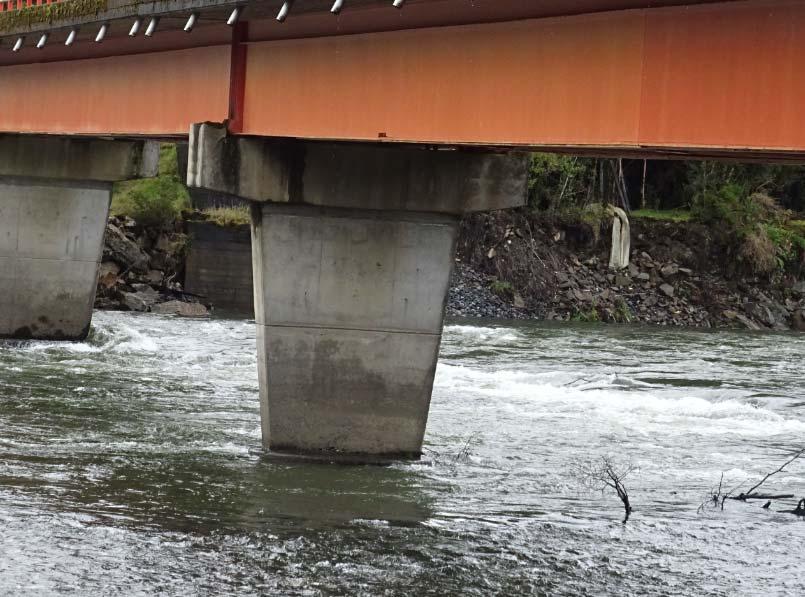
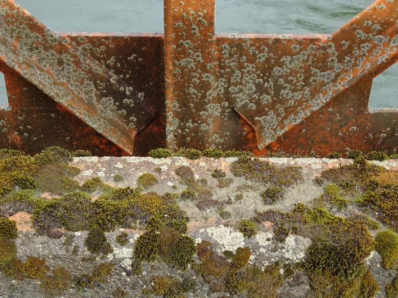
41 Infrastructure: Define the inspection considering hazard level Bridge: Raya Typology: Traditional Volcano Hazards


42 Protocol of Inspection Team: 7 Professional + 1 Technical Monography review Maintenance and GRDR sheets Micro and Macro Inspection
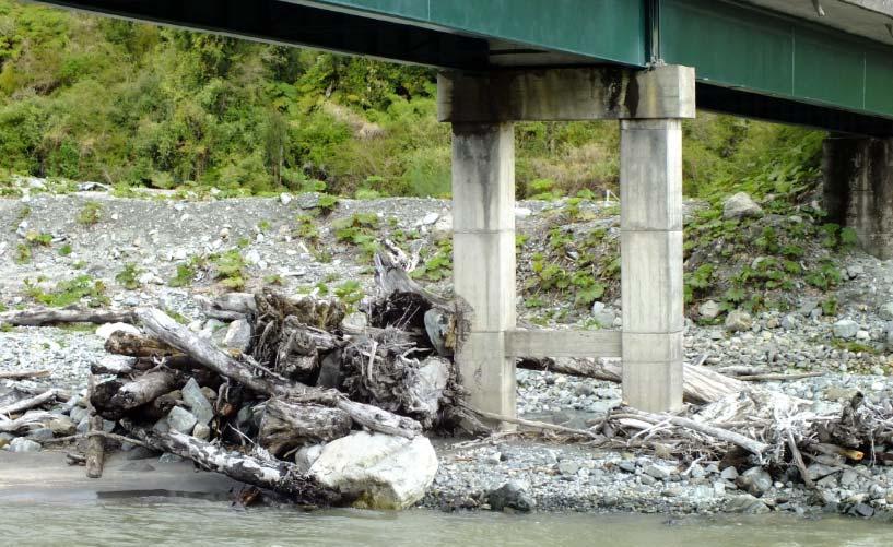
43 Technical Inspection Carol Urzúa Bridge Raya Bridge
44 Technical Inspection Yelcho Bridge El Amarillo Bridge
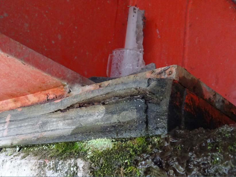
45 Technical Inspection Michimahuida Bridge Exequiel González Bridge


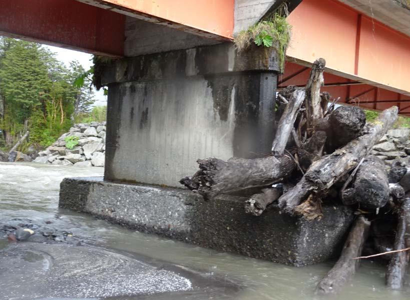
46 Non Considered Hazard on Bridge area. Fires Future implementation Wood Fire Under the Bridge


47 Future research GRDR Start up: Valparaiso Region (Tsunami, Earthquake, Landslides and Fires) Update Maintenance Sheet for phase 1 and 2. Update Hazard Sheet and Catalog of Pathologies of GRDR To develop optimization algorithm and software solutions


48 Santiago CHILE 18 al 20 de Octubre de 2017 October 18 to 20, 2017 SECOND INTERNATIONAL BRIDGES CONGRESS - CHILE 2017, DESIGN, CONSTRUCTION AND MAINTENANCE Venue Santiago - Chile Dates October 2017 matias.valenzuela@pucv.cl Organizan / Organized by
Seismic vulnerability in Latinamerica Speaker: Rafael Osiris de León Sciences Academy of Dominican Republic.
 Seismic vulnerability in Latinamerica Speaker: Rafael Osiris de León Sciences Academy of Dominican Republic. IANAS GENERAL ASSEMBLY Punta Cana, 16-20 July, 2013 TECTONIC PLATES AND EARTHQUAKES Pacific
International Cooperation on Earthquake Disaster Management to Protect Lives
 Pontificia Universidad Católica de Chile Chile, un país s con múltiples m amenazas International Cooperation on Earthquake Disaster Management to Protect Lives Raúl Alvarez Medel, Pontificia Universidad
The World Bank Ecuador Risk Mitigation and Emergency Recovery Project (P157324)
") Public Disclosure Authorized LATIN AMERICA AND CARIBBEAN Ecuador Social, Urban, Rural and Resilience Global Practice Global Practice IBRD/IDA Investment Project Financing FY 2016 Seq No: 2 ARCHIVED on
Public Disclosure Authorized LATIN AMERICA AND CARIBBEAN Ecuador Social, Urban, Rural and Resilience Global Practice Global Practice IBRD/IDA Investment Project Financing FY 2016 Seq No: 2 ARCHIVED on
Revealing the interaction between Society and Nature. DesInventar, disaster inventories for damage and loss assessment
 UNFCCC Regional expert meeting on a range approaches to address loss and damage associated with the adverse effects climate change, including impacts related to extreme weather events and slow onset events
Lesson 8. Natural Disasters
 Lesson 8 Natural Disasters 1 Reading is NOT a spectator sport! 2 Reading requires active participation! 3 PREDICT Try to figure out what information will come next and how the selection might end. 4 Natural
Strategic Framework on Geospatial Information and Services for Disasters Relevance for the Americas Region
 Strategic Framework on Geospatial Information and Services for Disasters Relevance for the Americas Region Seventh Session of the Committee of Experts on UN-GGIM Side Event --- UN Headquarters, New York
Assessing Hazards and Risk
 Page 1 of 6 EENS 204 Tulane University Natural Disasters Prof. Stephen A. Nelson Assessing Hazards and Risk This page last updated on 07-Jan-2004 As discussed before, natural disasters are produced by
GENERAL. CHAPTER 1 BACKGROUND AND PURPOSE OF THE GUIDELINES Background of the Guidelines Purpose of the Guidelines...
 GENERAL CHAPTER 1 BACKGROUND AND PURPOSE OF THE GUIDELINES... 1 1.1 Background of the Guidelines... 1 1.2 Purpose of the Guidelines... 3 CHAPTER 2 APPLICATION OF THE GUIDELINES... 3 2.1 Potential Users
Disaster Risk Management in India. Kamal Kishore New Delhi, 27 October 2016
 Disaster Risk Management in India Kamal Kishore New Delhi, 27 October 2016 Hazard, Exposure and Vulnerability Disaster Prevention Mitigation Hurricane Matthew: Cuba & Haiti Emergency Response Coordination
They include earthquakes, volcanic eruptions, floods, landslides, and other processes and occurrences. They are included in the broader concept of.
 They include earthquakes, volcanic eruptions, floods, landslides, and other processes and occurrences. They are included in the broader concept of. In general, natural processes are labeled hazardous only
THE STUDY ON 4S TECHNOLOGY IN THE COMMAND OF EARTHQUAKE DISASTER EMERGENCY 1
 THE STUDY ON 4S TECHNOLOGY IN THE COMMAND OF EARTHQUAKE DISASTER EMERGENCY 1 Zhou Wensheng 1, Huang Jianxi 2, Li Qiang 3, Liu Ze 3 1 Associate Professor, School of Architecture, Tsinghua University, Beijing.
Disaster Risk Assessment: Opportunities for GIS and data management with Open DRI
 Disaster Risk Assessment: Opportunities for GIS and data management with Open DRI Jacob Opadeyi Department of Geomatics Engineering and Land Management, The University of the West Indies, St. Augustine,
United States Multi-Hazard Early Warning System
 United States Multi-Hazard Early Warning System Saving Lives Through Partnership Lynn Maximuk National Weather Service Director, Central Region Kansas City, Missouri America s s Weather Enterprise: Protecting
Use of Geospatial data for disaster managements
 Use of Geospatial data for disaster managements Source: http://alertsystemsgroup.com Instructor : Professor Dr. Yuji Murayama Teaching Assistant : Manjula Ranagalage What is GIS? A powerful set of tools
2018 REVIEW OF DISASTER EVENTS
 2018 REVIEW OF DISASTER EVENTS Supplementary Information* BRUSSELS, 24 January, 2019 In 2018, there were 281 climate-related and geophysical events recorded in the EM-DAT (International Disaster Database)
A science-policy approach towards local adaptation planning: The case of Santiago de Chile
 A science-policy approach towards local adaptation planning: The case of Santiago de Chile Kerstin Krellenberg, PhD Resilient Cities 2011 2nd World Congress on Cities and Adaptation to Climate Change Bonn,
TOOLS FOR RISK MANAGEMENT Related to climate change
 TOOLS FOR RISK MANAGEMENT Related to climate change copyright CONTENT 1 CLIMATE CHANGE AND ENVIRONMENTAL STUDIES 2 METHODS AND TOOLS DEVELOPED BY EGIS For infrastructures For urban areas For crisis management
Deadly Earthquake Strikes Peru
 Deadly Earthquake Strikes Peru KEY POINTS On 14 January 2018, a magnitude-7.1 earthquake struck off the coast of Peru. At least two people have been reported dead, with dozens more left injured or homeless.
Disaster Management and Spatial Data An Experience of Sri Lanka for Joint project team meeting 2012
 Disaster Management and Spatial Data An Experience of Sri Lanka for Joint project team meeting 2012 1 by Padma Kumara Withana Provincial Surveyor General Uva Province 2 Out line ü Introduction ü Natural
FINAL EXAM December 20 th, here at 1:00 3:00 pm
 FINAL EXAM December 20 th, here at 1:00 3:00 pm REVIEW SESSION December 11 th at 6:00-7:30 pm Morrill I Auditorium (Room N375) Same as last time Don t forget your online course evaluations! Major Volcanic
Crisis Support and Disaster Response. in Latin America and the Caribbean
 Crisis Support and Disaster Response in Latin America and the Caribbean The Pan American Agenda 2010-2020 of the Pan American Institute of Geography and History (PAIGH), and the resulting 2010 Implementation
Debris flow: categories, characteristics, hazard assessment, mitigation measures. Hariklia D. SKILODIMOU, George D. BATHRELLOS
 Debris flow: categories, characteristics, hazard assessment, mitigation measures Hariklia D. SKILODIMOU, George D. BATHRELLOS Natural hazards: physical phenomena, active in geological time capable of producing
Pacific Catastrophe Risk Assessment And Financing Initiative
 Pacific Catastrophe Risk Assessment And Financing Initiative PALAU September is expected to incur, on average,.7 million USD per year in losses due to earthquakes and tropical cyclones. In the next 5 years,
Pacific Catastrophe Risk Assessment And Financing Initiative
 Pacific Catastrophe Risk Assessment And Financing Initiative VANUATU September 211 Country Risk Profile: VANUATU is expected to incur, on average, 48 million USD per year in losses due to earthquakes and
Hazardous Weather and Flooding Preparedness. Hazardous Weather and Flooding Preparedness
 Hazardous Weather and Flooding Preparedness 1 A Cooperative Effort 2 Administrative Information Emergency exits and procedures Location of restrooms Mobile devices Procedure for questions Course materials
Forecast- Financing. El Niño in Peru. Changing the paradigm, acting faster
 Forecast- Financing Changing the paradigm, acting faster El Niño in Peru WHAT IS EL NIÑO? El Niño and rainfall 2 El Niño is a complex interaction of the tropical Pacific and the atmosphere, resulting in
Theme 4. Disaster Mitigation and Risk Management
 Theme 4 Disaster Mitigation and Risk Management World Flood Map in 2002 Released by WMO as of August 29 Over 17 million were affected (in more than 80 countries) 3,000 were killed Total damage of over
b. Why is the area affected by each earthquake circular or nearly circular? Where is the epicenter of each quake located?
 Name: Skill Sheet 29-A Interpreting Geologic Hazard Maps Plate tectonics and the weather are often the cause of geologic hazards such as earthquakes, volcanic eruptions, and flooding. Geologic hazard events
By Lillian Ntshwarisang Department of Meteorological Services Phone:
 By Lillian Ntshwarisang Department of Meteorological Services Phone: +267 3612200 Email: lntshwarisang@gov.bw/ lntshwarisang@gmail.com Introduction Mandate of DMS Function of the Department Services to
Earthquake Hazards. Tsunami
 Earthquake Hazards Tsunami Review: What is an earthquake? Earthquake is the vibration (shaking) and/or displacement of the ground produced by the sudden release of energy. The point inside the Earth where
Shake, Rattle n Roll! Earthquake Science & Safety. STACEY EDWARDS Education Officer The University of the West Indies Seismic Research Centre
 Shake, Rattle n Roll! Earthquake Science & Safety STACEY EDWARDS Education Officer The University of the West Indies Seismic Research Centre User Notes This presentation may contain animations, video clips
Earthquake Hazards. Tsunami
 Earthquake Hazards Tsunami Review: What is an earthquake? Earthquake is the vibration (shaking) and/or displacement of the ground produced by the sudden release of energy. The point inside the Earth where
7.3 Magnitude Earthquake Strikes Iran-Iraq Border
 7.3 Magnitude Earthquake Strikes Iran-Iraq Border KEY POINTS A magnitude 7.3 earthquake has struck the Iran-Iraq border with at least 348 fatalities reported. Thousands more have been injured and many
RISK ASSESSMENT COMMUNITY PROFILE NATURAL HAZARDS COMMUNITY RISK PROFILES. Page 13 of 524
 RISK ASSESSMENT COMMUNITY PROFILE NATURAL HAZARDS COMMUNITY RISK PROFILES Page 13 of 524 Introduction The Risk Assessment identifies and characterizes Tillamook County s natural hazards and describes how
Roles of NGII in successful disaster management
 The Second UN-GGIM-AP Plenary Meeting Roles of NGII in successful disaster management Republic of Korea Teheran Iran 28 October 2013 Sanghoon Lee, Ph.D. NGII Outline Type of Disasters Occur in Korea Practical
Source:
 Source: http://www.pastforward.ca/perspectives/columns/10_02_05.htm At 16:53, on Wednesday, January 12th, 2010, a devastating 7.0 earthquake struck Haiti's capital, Port-au-Prince. The earthquake left
Assessment Objectives Grid for Geography - G1. Summer Application Skills Total. (a) (b) (c) (a)
 (b) (c) (a)") Assessment Objectives Grid for Geography - G1 Summer 2014 Question 1 Knowledge and Understanding Application Skills Total Key Question (a) 0 2 3 5 1.5 (b) 8 2 10 1.3 (c) 7 3 10 1.4 15 7 3 25 Question 2
Assessment Objectives Grid for Geography - G1 Summer 2014 Question 1 Knowledge and Understanding Application Skills Total Key Question (a) 0 2 3 5 1.5 (b) 8 2 10 1.3 (c) 7 3 10 1.4 15 7 3 25 Question 2
RiskCity Training package on the Application of GIS for multi- hazard risk assessment in an urban environment.
 RiskCity Training package on the Application of GIS for multi- hazard risk assessment in an urban environment. Cees van Westen (Westen@itc.nl) & Nanette C. Kingma (Kingma@itc.nl) ITC: Training & Research
Initiative. Country Risk Profile: papua new guinea. Better Risk Information for Smarter Investments PAPUA NEW GUINEA.
 Pacific Catastrophe Risk Assessment And Financing Initiative PAPUA NEW GUINEA September 211 Country Risk Profile: papua new is expected to incur, on average, 85 million USD per year in losses due to earthquakes
Earthquakes. & Expansive Soils
 Earthquakes & Expansive Soils January 22, 2009 Plan Update Flanagan & Associates, LLC Consultants Tulsa, OK www.rdflanagan.com rdflanagan@rdflanagan.com Plan can be reviewed at: www.rdflanagan.com/.html
5.2 IDENTIFICATION OF HAZARDS OF CONCERN
 5.2 IDENTIFICATION OF HAZARDS OF CONCERN 2016 HMP Update Changes The 2011 HMP hazard identification was presented in Section 3. For the 2016 HMP update, the hazard identification is presented in subsection
UN-GGIM:Americas Regional Report
 UN-GGIM:Americas Regional Report 2016-2017 Seventh Session of UN-GGIM 2-4 August 2017, United Nations Headquarters, New York. Rolando Ocampo President of UN-GGIM: Americas Content Activities, Areas of
INDONESIA IMPACT BASED FORECAST PROGRAM
 INDONESIA IMPACT BASED FORECAST PROGRAM Seoul, 19-21 November 2018 The 2nd Regional Workshop on Impact-based Forecasts in Asia Indonesia Agency for Meteorology Climatology and Geophysics (BMKG) A. Fachri
Earthquake Hazards. Tsunami
 Earthquake Hazards Tsunami Measuring Earthquakes Two measurements that describe the power or strength of an earthquake are: Intensity a measure of the degree of earthquake shaking at a given locale based
President s Day Weekend Storm Community Meeting and Workshop April 17, 2017
 President s Day Weekend Storm Community Meeting and Workshop April 17, 2017 Meeting outline 1. Progress update on the City of San Jose s recovery efforts 2. Water district presentation on: Weather situation
Prentice Hall World Studies: Latin America 2005 Correlated to: Missouri Social Studies Grade Level Expectations (Grade 7)
") Principles of Constitutional Democracy 1. Knowledge of the principles expressed in documents shaping constitutional democracy in the United States A. (1) Principles expressed in documents shaping constitutional
Principles of Constitutional Democracy 1. Knowledge of the principles expressed in documents shaping constitutional democracy in the United States A. (1) Principles expressed in documents shaping constitutional
DIPLOMA IN DISASTER MANAGEMENT. (Non-Semester) (With effect from the academic year )
 (With effect from the academic year )") DIPLOMA IN DISASTER MANAGEMENT (Non-Semester) (With effect from the academic year 2013-14) Eligibility for the Course Candidate should have passed the Higher Secondary Examination conducted by the Board
DIPLOMA IN DISASTER MANAGEMENT (Non-Semester) (With effect from the academic year 2013-14) Eligibility for the Course Candidate should have passed the Higher Secondary Examination conducted by the Board
Geospatial Information Management in the Americas: Lessons for the Post-2015 development agenda
 Geospatial Information Management in the Americas: Lessons for the Post-2015 development agenda Rolando Ocampo President, UN-GGIM: Americas October 2014 The integration of statistical and geographical
Disaster RISK Management : Bhutanese Scenario
 Disaster RISK Management : Bhutanese Scenario Expert Group Meeting (EGM) on Geo-referenced Information Systems for Disaster Risk Management (Geo-DRM) and sustaining the Community of Practice (COP), Bangkok,
Montserrat Eruption = Monster rat
 Montserrat Eruption 1997 = Monster rat Small island in the Caribbean sea Montserrat is a small... Soufriere Hills volcano Key facts: Date: 25 th June 1997 (small eruptions began in July 1995) Size: 4.5
Baldwin County, Alabama
 2015 Baldwin County, Alabama Multi-Hazard Mitigation Plan I. Comprehensive Plan A multi-jurisdiction plan City of Bay Minette City of Daphne Town of Elberta City of Fairhope City of Foley City of Gulf
Also, when Cascade volcanoes do erupt, high-speed avalanches of pyroclastic flows
 INTRODUCTION A volcano is a vent through which molten rock escapes to the Earth s surface. Unlike other mountains, which are pushed up from below, volcanoes are built by surface accumulation of their eruptive
Jeopardy. Final Jeopardy $100 $100 $100 $100 $100 $200 $200 $200 $200 $200 $300 $300 $300 $300 $400 $400 $400 $500 $500 $500 $500 $500
 Jeopardy Earthquakes Volcanoes Tsunamis Wildfires Landslides/ Droughts $100 $100 $100 $100 $100 $200 $200 $200 $200 $200 $300 $300 $300 $300 $300 $400 $400 $400 $400 $400 $500 $500 $500 $500 $500 Final
Pacific Catastrophe Risk Assessment And Financing Initiative
 Pacific Catastrophe Risk Assessment And Financing Initiative TUVALU is expected to incur, on average,. million USD per year in losses due to earthquakes and tropical cyclones. In the next 5 years, has
Volcanoes. Introduction
 Volcanoes Introduction Display Slide V-0 Explain that a volcano is a vent through which molten rock escapes to the Earth s surface. Unlike other mountains, which are pushed up from below, volcanoes are
NGIAs' roles in successful disaster response
 The Second UN-GGIM-AP Plenary Meeting NGIAs' roles in successful disaster response Japan Teheran Iran 28 October 2013 Shin-ichi SAKABE, Director of International Affairs Division Geospatial Information
Incorporation of the Caribbean to the Geocentric Reference System for the Americas SIRGAS
 Incorporation of the Caribbean to the Geocentric Reference System for the Americas SIRGAS W. Martínez M. V. Mackern V. Cioce R. Rodino S.R. De Freitas UN-GGIM: Americas Third Session, October 5 2016, Mexico
The Third UN-GGIM-AP Plenary Meeting. Use of Geospatial Information in Disaster and Coordination among NDMA and Relevant Organizations/Stakeholders
 The Third UN-GGIM-AP Plenary Meeting Use of Geospatial Information in Disaster and Coordination among NDMA and Relevant Organizations/Stakeholders Bali Indonesia 10 November 2014 Bernardus Wisnu Widjaja
DRR-related mandates and relevant activities and projects of RA III
 DRR-related mandates and relevant activities and projects of RA III 2015 Meeting of the Disaster Risk Reduction Focal Points of WMO Regional Associations, Technical Commissions and Programmes (DRR FP RA-TC-TP)
USING 3D GIS TO ASSESS ENVIRONMENTAL FLOOD HAZARDS IN MINA
 King Fahd University of Petroleum & Minerals College of Environmental Design Geographical Information system USING 3D GIS TO ASSESS ENVIRONMENTAL FLOOD HAZARDS IN MINA Prepared by : Ali AL-Zahrani OUTLINE
City of Punta Gorda Community Emergency Management Plan 2013
 City of Punta Gorda Community Emergency Management Plan 2013 Hurricane Andrew- August 24, 1992 Category 5 hurricane. The second-most-destructive hurricane in U.S. history. The first named storm of the
Introduction to time-use surveys
 Regional seminar on time-use surveys Introduction to time-use surveys Kingstown, Saint Vincent and the Grenadines 10-11 December 2014 Iliana Vaca Lucía Scuro Division of Gender Affairs WHAT IS TIME? Measured
Wainui Beach Management Strategy (WBMS) Summary of Existing Documents. GNS Tsunami Reports
 Summary of Existing Documents. GNS Tsunami Reports") Wainui Beach Management Strategy (WBMS) Summary of Existing Documents GNS Tsunami Reports a) Review of Tsunami Hazard and Risk in New Zealand ( National Risk Report ) b) Review of New Zealand s Preparedness
Wainui Beach Management Strategy (WBMS) Summary of Existing Documents GNS Tsunami Reports a) Review of Tsunami Hazard and Risk in New Zealand ( National Risk Report ) b) Review of New Zealand s Preparedness
EuroGeoSurveys & ASGMI The Geological Surveys of Europe and IberoAmerica
 EuroGeoSurveys & ASGMI The Geological Surveys of Europe and IberoAmerica Geological Surveys, what role? Legal mandate for data & information: Research Collection Management Interpretation/transformation
What Are Disasters? The Rescue Kids Trio!
 The Rescue Kids Trio! What Are Disasters? This manual was made possible through funding by the Council of Local Authorities for International Relations. Disasters and emergency preparedness Emergency preparedness
FROM SCIENCE TO ACTION: THE RISK ANALYST INTERMEDIARY
 FROM SCIENCE TO ACTION: THE RISK ANALYST INTERMEDIARY Gordon Woo Rome, 8 October, 2014 Many natural hazard stakeholders Civil protection, police and military authorities Infrastructure utility and transport
M 7.1 EARTHQUAKE 5KM ENE OF RABOSO, MEXICO EXACT LOCATION: N W DEPTH: 51.0KM SEPTEMBER 19, 1:14 LOCAL TIME
 M 7.1 EARTHQUAKE 5KM ENE OF RABOSO, MEXICO EXACT LOCATION: 18.584 N 98.399 W DEPTH: 51.0KM SEPTEMBER 19, 2017 @ 1:14 LOCAL TIME Photo: Eduardo Verdugo / AP Photo: Alfredo Estrella/ Agence France-Presse/
Word Cards. 2 map. 1 geographic representation. a description or portrayal of the Earth or parts of the Earth. a visual representation of an area
 Name: Date: Hour: Word Cards 1 geographic representation a description or portrayal of the Earth or parts of the Earth Example: A map is a representation of an actual location or place. 2 map a visual
Project on Seismic Hazard & Vulnerability. areas, Bangladesh. Mohammad Ashraful Kamal (Geologist)
") Project on Seismic Hazard & Vulnerability Assessment in Dhaka, Chittagong & Sylhet city areas, Bangladesh By Mohammad Ashraful Kamal (Geologist) Tectonic & Seismic zoning map of Bangladesh Geological map
Project on Seismic Hazard & Vulnerability Assessment in Dhaka, Chittagong & Sylhet city areas, Bangladesh By Mohammad Ashraful Kamal (Geologist) Tectonic & Seismic zoning map of Bangladesh Geological map
Hurricane Katrina kills hundreds
 www.breaking News English.com Ready-to-use ESL / EFL Lessons Hurricane Katrina kills hundreds URL: http://www.breakingnewsenglish.com/0508/050831-katrina-e.html Today s contents The Article 2 Warm-ups
The Role of Data & Information Infrastructures in Supporting Climate Change Adaptation in Latin America & the Caribbean
 The Role of Data & Information Infrastructures in Supporting Climate Change Adaptation in Latin America & the Caribbean Emil A. Cherrington Senior Scientist Water Center for the Humid Tropics of Latin
World Meteorological Organization
 World Meteorological Organization Opportunities and Challenges for Development of Weather-based Insurance and Derivatives Markets in Developing Countries By Maryam Golnaraghi, Ph.D. Head of WMO Disaster
SCENARIO DESIGN ON THE IMPACT OF A HIGH-MAGNITUDE EARTHQUAKE IN THE CITY OF LIMA, PERU
 SCENARIO DESIGN ON THE IMPACT EARTHQUAKE IN THE CITY OF LIMA, Methodology Determination of the characteristics of the probable earthquake (magnitude, intensity, acceleration). Seismic geotechnical soil
Trends of Natural Disasters in the Asia- Pacific Region and the Direction of Disaster Management
 2016 APEC SCCC, Arequipa, Peru Session 6 - Human Security: Food, Health, Natural Disasters and Environmental Issues Trends of Natural Disasters in the Asia- Pacific Region and the Direction of Disaster
The Role of Science and Technology in Earthquake Hazard Characterization: A Chilean Experience
 The Role of Science and Technology in Earthquake Hazard Characterization: A Chilean Experience STI Contribution to Policy Making on Natural Disaster Resilience APEC Workshop, 1-2 August 2018 Santiago -
Climate Science to Inform Climate Choices. Julia Slingo, Met Office Chief Scientist
 Climate Science to Inform Climate Choices Julia Slingo, Met Office Chief Scientist Taking the planet into uncharted territory Impacts of climate change will be felt most profoundly through hazardous weather
Pacific Catastrophe Risk Assessment And Financing Initiative
 Pacific Catastrophe Risk Assessment And Financing Initiative TIMOR-LESTE September Timor-Leste is expected to incur, on average, 5.9 million USD per year in losses due to earthquakes and tropical cyclones.
ENSURE. Coordinator: Hormoz MODARESSI Website:
 ENSURE Coordinator: Hormoz MODARESSI h.modaressi@brgm.fr Website: http://ensureproject.eu/ The project is financed by the European Commission under the 7th Framework Programme for Research and Technological
M-6.2 EARTHQUAKE NORCIA, ITALY AUGUST 24, 01:36:33 UTC
 M-6.2 EARTHQUAKE NORCIA, ITALY AUGUST 24, 2016 @ 01:36:33 UTC EARTHQUAKE REPORT - NORCIA, ITALY M-6.2, 24 August 2016 The M-6.2 earthquake had a shallow depth (10 km) and struck approximately 10 km SE
José Luis Palma, William Rose and Rüdiger Escobar Wolf Department of Geological Engineering and Sciences Michigan Technological University
 Assessing the Volcanic Threat of Central American Volcanoes José Luis Palma, William Rose and Rüdiger Escobar Wolf Department of Geological Engineering and Sciences Michigan Technological University Outline
THE WEATHER CASE STUDIES
 THE WEATHER CASE STUDIES Hedi Maurer, NEA (Panteia) Athens, 23.04.2012 Case studies, regions and modes 1. Flood of 2002 in Eastern Germany 2. Summer heat 2007 in Southern Europe 3. Flooding of the rail
WMO Statement on the State of the Global Climate Preliminary conclusions for 2018 and WMO Greenhouse Bulletin
 WMO Statement on the State of the Global Climate Preliminary conclusions for 2018 and WMO Greenhouse Bulletin Dr Elena Manaenkova Deputy Secretary General World Meteorological Organisation Statement on
The Politics of Tornadoes The Impacts of Sudden Storm Events on People
 The Politics of Tornadoes The Impacts of Sudden Storm Events on People Today s Discussion Brief Review Student Presentation When the Sky Kills Impacts of Tornadoes Questions & Discussion Next Class Brief
Like other coastal cities, Honolulu s
 Worst-Case Scenarios: Flooding and Evacuation Plans in Honolulu Karl Kim, Pradip Pant, Eric Yamashita Like other coastal cities, Honolulu s long-term viability depends on how well it can adapt to climate
Tropical Cyclone Isaac (AL092012)
") Tropical Cyclone Isaac (AL092012) Event Briefing, Central Caribbean Impacts Caribbean Risk Managers Ltd Facility Supervisor 27 August 2012 Facility Supervisor: Caribbean Risk Managers Ltd Email: ccrif@ccrif.org
Tropical Cyclone Isaac (AL092012) Event Briefing, Central Caribbean Impacts Caribbean Risk Managers Ltd Facility Supervisor 27 August 2012 Facility Supervisor: Caribbean Risk Managers Ltd Email: ccrif@ccrif.org
Tsunami Research and Its Practical Use for Hazard Mitigation. Hiroo Kanamori Seismological Laboratory, California Institute of Technology
 Tsunami Research and Its Practical Use for Hazard Mitigation Hiroo Kanamori Seismological Laboratory, California Institute of Technology Cause of Tsunami Earthquakes Landslides Volcanic origin Impact (Dr.
Using Operating Experience to Prevent or Mitigate Nuclear Events. What Is, Was and Will Be Available
 Using Operating Experience to Prevent or Mitigate Nuclear Events What Is, Was and Will Be Available Introduction Remember, it is by understanding the lessons learned from past events that we can adequately
World Meteorological Organization
 Appendix VI Presentation on disaster risk reduction brainstorming session (1) World Meteorological Organization WMO DRR Programme Dieter C. Schiessl Director, Weather and Disaster Risk Reduction Services
Mitigation planning in Epirus- The case of frost and snowfalls. Thematic seminar Epirus September 2011
 Mitigation planning in Epirus- The case of frost and snowfalls Thematic seminar Epirus September 2011 1 Structure of Mitigation Planning in Greece First Level: General Plan for Civil Protection Ksenokratis
Advanced Workshop on Evaluating, Monitoring and Communicating Volcanic and Seismic Hazards in East Africa.
 2053-13 Advanced Workshop on Evaluating, Monitoring and Communicating Volcanic and Seismic Hazards in East Africa 17-28 August 2009 Hazard Communication: Examples From Tanzania, Mozambique, and Cameroon
TABLE OF CONTENTS LIST OF TABLES. Page
 TABLE OF CONTENTS Page 11.0 EFFECTS OF THE ENVIRONMENT ON THE PROJECT... 11-1 11.1 Weather Conditions... 11-1 11.2 Flooding... 11-2 11.3 Forest Fires... 11-2 11.4 Permafrost and Subsidence Risk... 11-3
4.1 Hazard Identification: Natural Hazards
 data is provided in an annex, it should be assumed that the risk and potential impacts to the affected jurisdiction are similar to those described here for the entire Sacramento County Planning Area. This
Geospatial natural disaster management
 Geospatial natural disaster management disasters happen. are you ready? Natural disasters can strike almost anywhere at any time, with no regard to a municipality s financial resources. These extraordinarily
COMMUNITY EMERGENCY RESPONSE TEAM
 COMMUNITY EMERGENCY RESPONSE TEAM INSTRUCTOR GUIDE 40 hour curriculum DEVELOPED FOR: FEDERAL EMERGENCY MANAGEMENT AGENCY EMERGENCY MANAGEMENT INSTITUTE UNITED STATES FIRE ADMINISTRATION DEVELOPED BY: HUMAN
Flash Flood Guidance System On-going Enhancements
 Flash Flood Guidance System On-going Enhancements Hydrologic Research Center, USA Technical Developer SAOFFG Steering Committee Meeting 1 10-12 July 2017 Jakarta, INDONESIA Theresa M. Modrick Hansen, PhD
WHAT HAPPENS WHEN A TORNADO STRIKES THE COMMUNITY? Carroll County Sheriff s Office Emergency Management
 WHAT HAPPENS WHEN A TORNADO STRIKES THE COMMUNITY? Carroll County Sheriff s Office Emergency Management WHAT IS EMERGENCY MANAGEMENT? Carroll County Sheriff s Office Emergency Management Agency is responsible
GUIDELINES FOR CONSTRUCTION TECHNOLOGY TRANSFER DEVELOPMENT OF WARNING AND EVACUATION SYSTEM AGAINST SEDIMENT DISASTERS IN DEVELOPING COUNTRIES
 GUIDELINES FOR CONSTRUCTION TECHNOLOGY TRANSFER DEVELOPMENT OF WARNING AND EVACUATION SYSTEM AGAINST SEDIMENT DISASTERS IN DEVELOPING COUNTRIES MARCH 2004 Ministry of Land, Infrastructure and Transport
DEVELOPING A TRANSPORTATION PLAN FOR EVACUATION OF BUILDUP AREAS IN CASE OF EARTHQUAKE "CASE STUDY"
 DEVELOPING A TRANSPORTATION PLAN FOR EVACUATION OF BUILDUP AREAS IN CASE OF EARTHQUAKE "CASE STUDY" Osama A. Abaza Associate Professor, Civil Engineering Dept., University of Alaska Anchorage, Anchorage,
Lessons Learned from Past Tsunamis Warning and Emergency Response
 UNESCO IOC CTIC US NOAA ITIC Regional Training Workshop on Strengthening Tsunami Warning and Emergency Response Standard Operating Procedures and the Development of the ICG/CARIBE-EWS PTWC New Enhanced
Assessing the Volcanic Threat in Latin America. Jose L. Palma, University at Buffalo Bill Rose, Michigan Technological University
 Assessing the Volcanic Threat in Latin America Jose L. Palma, University at Buffalo Bill Rose, Michigan Technological University PASI Workshop, January 2011 Natural Disasters by Type, 1991-2005 90% 7%