mountain building episodes
|
|
|
- Morgan Bond
- 6 years ago
- Views:
Transcription


1 EarlyTertiaryTectonicsand mountain building episodes Jarðsaga 2 - Saga Lífs og Jarðar - Ólafur Ingólfsson

2 The World as we know it largely a product of Cenozoic tectonics and volcanism...
3
")
4 Mountain building (orogenic and volcanic) in process
5 Volcanism and the opening up of the North Atlantic During Cretaceous times, N America, Greenland, and Eurasia were part of a common land mass. Early in the Cenozoic, about 60 MY ago, sea-floor spreading began between Greenland and Europe. Continued sea-floor spreading between North America and Greenland led to opening of Baffin Bay. Volcanism on western Greenland, Greenland acted as an independent plate during the early Cenozoic. Thick basalt plateaus built up in eastern Greenland, western Scotland, northern Ireland and the Faeroes
6
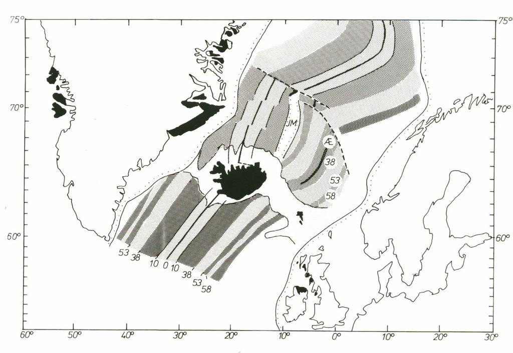
7
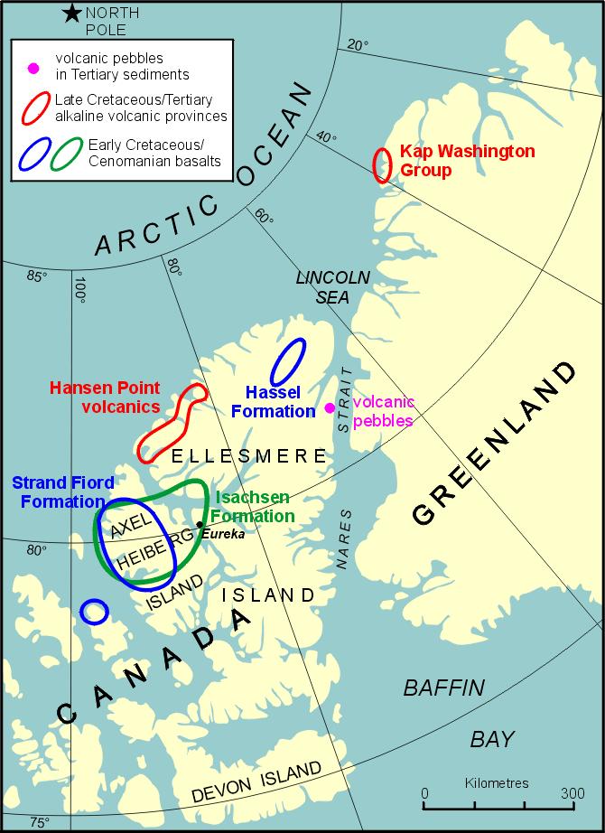
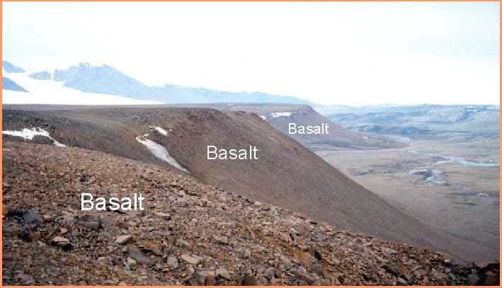
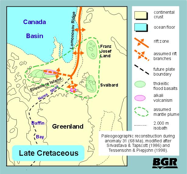
8 Cretaceous-Tertiary basalts in Arctic Canada and northern Greenland


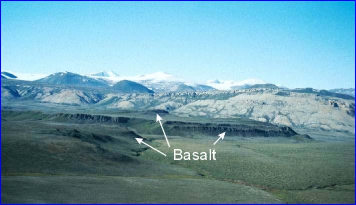
9 Early Tertiary volcanism on central West Greenland Hyaloclastite breccias and lava flows of the Vaigat Formation on the south coast of Nuussuaq. Cretaceous and Paleocene sandstones and shales are present below the volcanic rocks. The cliff is about 1300 m high. Photo: Asger K. Pedersen, Geological Museum, Copenhagen.

10 Tertiary basalt plateau, Disko Island
11 Tertiary basalts, East Greenland In East Greenland early Tertiary volcanic rocks crop out between latitudes 68 o and c. 75 o N. South of Scoresby Sund/Kangertittivaq (c. 70 o N) plateau basalts cover an extensive region of c km 2

12 Flood basalts in Greenland

13 Major Tertiary intrusive centres in East Grennland


14 Basalt dykes, East Greenland An early Tertiary dike in Archean gneiss, Scoresby Sund area, E Greenland A Tertiary dike swarm, Scoresby Sund area, East Greenland

15 North Atlantic/Iceland Hotspot Circles indicate hypothesised locations of an Icelandic mantle plume at the times indicated in MY.
16

17 Land bridge over Iceland... The Tertiary biota of Iceland is closely related to the modern Eastern Deciduous Forests of N America. Flora and fauna used the dynamic land bridge between North America and Europe via Greenland- Iceland as a migration route during the Paleogene. This land bridge emerged due to hotspot activity on the Mid Atlantic ridge in connection with the opening of the N Atlantic.
18

19 Early Tertiary land bridge across Iceland Plate reconstruction to 60 Ma with simplified seafloor. The main dike trend in the British Volcanic Province schematically shown to extend to the West Greenland magmatic area


20 Tertiary basalts in Ireland 60 MY ago the Antrim area, Ireland, was subject to intense volcanic activity. There were three periods of volcanic activity which resulted in the flows, known as the Lower, Middle and Upper Basalts. It is the Middle Basalts rocks which forms the columns of the Giants Causeway.


21 ...and Scotland Staffa: Fingal's Cave and the columnar jointing in Tertiary volcanic flows In early Tertiary, a volcanic chain ran down what is now the west coast of Scotland. The islands of Skye, Rum, Mull, Arran and St. Kilda, along with the Ardnamurchan Peninsula were all volcanic centres (above sea level). Although the volcanoes themselves no longer remain apparent, their lava flows and their eroded internal structures are obvious in the geology of Scotland.


22 Three series of plateaux basalts on the Faeroe Islands There was extensive volcanism on thefaeroeislandsduringthe period MY. The Tertiary basalts on the Faeroe Islands are divided into three series, the Lower-, Middle- and Upper series.

23 Thick Cenozoic sediments on top of the basalt pile The possibility for striking it rich and finding oil on the Faeroe Island shelf has led to extensive geophysical surveying and drilling.

 and clays")
24 Denmark was a sedimentary basin......below sea level until Miocene. Thick deposits of limestones (Paleocene) and clays (Eocene-Oligocene).

25 The Fur Formation Volcanic ash beds of late Paleocene-Eocene age accumulated in the Fur Formation, N Denmark. This formation is famous for its fossils, volcanic ash beds, and economic uses. The ash has similar geochemistry to plateau basalts of the Faeroes-East Greenland province


26 North Sea Oil... North Sea oil and gas has been generated from deeply-buried mudstone source rocks. Commercial petroleum reservoirs occur in almost every sedimentary succession ranging in age from ca MY. Sandstone reservoirs of Paleogene age are estimated to contain about 20% of the oil province s proven hydrocarbon reserves

27 The Early Tertiary Laramide Orogeny The Laramide Orogeny started in the Late Cretaceous and continued into Oligocene, The Alpine Orogeny started in early Eocene and continued into Miocene
28 Tectonic maps of N America and the N Atlantic The Laramide Orogeny
29 The Laramide Orogeny TheLaramide orogeny was a 30 million year period of mountain building in western N America that started in the Late Cretaceous, 70 MY ago, and ended in the Late Paleogene 40 MY ago. The major feature that was created by this orogeny was the Rocky Mountains. Evidence of the Laramide orogeny is present from Mexico to Alaska.

30 Cretaceous Paleogeography The Cretaceous paleogeography reflected a large inland sea, the last time such a sea would exist in North America. The east and south parts of the U.S. were very broad, lowlying terranes, whereas the largest mountain ranges of the Mesozoic in the west existed in the Cretaceous.

31 Early Tertiary paleogography In the Early Cenozoic, the subduction continued along the west coast, producing some igneous rocks, such as those at Devil's Tower NM in Wyoming. The Rocky Mountains region was dominated by the fold and thrust belt of the Laramide Orogeny.

32 Laramide Orogeny At the end of the Cretaceous and through the early Cenozoic, the Laramide orogeny, a huge deformational event, reached from the west coast deep into the continent to the Rocky Mountains and Great Plains. Extensive thrusting of Mesozoic and older rocks on top of younger rocks occurred throughout the Rocky Mountains, as well as broad warping of the continental basement (uplifting the Black Hills of South Dakota).

33 Laramide Orogeny very complex tectonics The Laramide orogeny originally was a poly- phaselatecretaceous- Oligocene orogeny, consisting of many disparate pulses of deformation that varied in intensity and age from place to place in western North America. /1998_Laramide/1998_Laramide.htm

34 Laramide Orogeny and sedimentary basins As the Rocky Mountains are uplifting, basins form between major uplifts. Huge lakes fill the basins during the Eocene.
.")
35 A Rocky Mts transect Uplifted blocks and down-dropped basins in central western USA. Very huge lake deposits (Green River Formation). Beginning of Yellowstone volcanism (a mantle plume underneath the American West)


36 The Lewis Thrust Fault A km long thrust fault, formed MY ago The Lewis thrust fault. The white Paleozoic limestone has been thrust over the brown Mesozoic shales
37 Rocky Mts still in the making The cause of the Laramide Orogeny is still debated, and may have been due to collision of an oceanic terrane to the west, or an nearly flat-dipping subduction zone that extended deformation deep into the continental interior. In the middle Cenozoic, the Laramide Orogeny Rocky Mts would be eroded down, only to be rejuvenated in the last 30 MY by the change in tectonic setting that occurred along the west coast, when the spreading center and subduction zone collided off the west coast, changing the plate boundary to the transform fault system of the San Andreas. Recent uplift and formation of the Sierra Nevada, Basin and Range, Colorado Plateau and modern Rocky Mountains occurred after this change in plate tectonic setting along the western margin.
38


39 Japan a product of Cenozoic tectonic events pics/2004/tp html

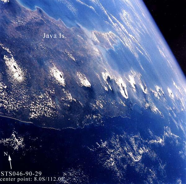
40 ...and so is Indonesia
41 Tectonic activity in Eurasia EarlytomiddleTertiarywasa periodof intense tectonic activity in Eurasia

42 The Alpine Orogeny The Alpine Orogeny was a mountain-building event that affected southern Europe and the Mediterranean region during the early-middle Tertiary Period. The Alpine orogeny produced intense metamorphism of preexisting rocks, crumpling of rock strata, and uplift accompanied by both normal and thrust faulting. It was responsible for the elevation of the present Alps, and for the uplifting of plateaus in the Balkan Peninsula and in Corsica and Sardinia.

43 The Alps seen from space
44 Collision of the African and Eurasian Plates In the late Cretaceous period, the African and Eurasion plates began to converge, closing the Tethys Ocean basin. The Mediterranean sea is remnants of this ancient ocean.
45 Very complex tectonics There are three major geomorphical settings within the Mediterranean basin: Areas with stable margin characteristics; Areas with unstable convergent margin charactericstics; Areas with extensional margin (rifting) characteristics.
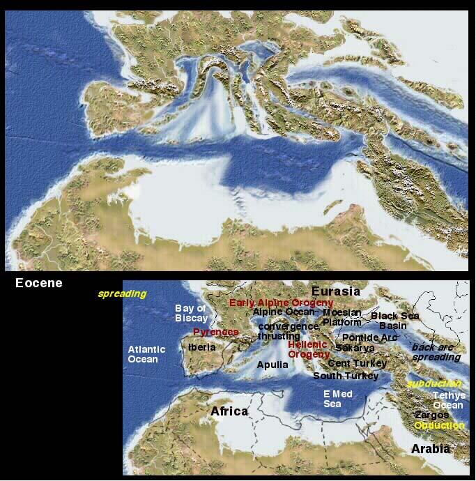
46

47 The Mediterranean basin is a location of an intercontinental interplate system; with compressional and extensional events occurring within close proximity.
48 Mediterrean volcanic activity and earthquakes All of the volcanic and seismic activity in the Mediterranean area is related to one or more of these processes; subduction, extension, or other tectonic events throughout the Cenozoic.

49 A continuum between the Alps and the Himalayas... The reddish brown landform clearly visible in the middle of this image is a great fold structure extending to the arid highlands in Pakistan, Afghanistan, and Iran.
50 Raising the Himalayas

51 The Grand Tertiary Collision About 80 million years ago, India was located roughly 6,400 km south of the Asian continent, moving northward at a rate of about 9 cm/yr. When India rammed into Asia about 40 to 50 million years ago, its northward advance slowed by about half.
52 Formation of the Himalayas 60 MY ago

53 Formation of the Himalayas 40 MY ago
54 Formation of the Himalayas 20 MY ago

55 Formation of the Himalayas Today


56 Much of the uplift has occurred during the past 10 MY

57 Present rate of uplift... The Himalayas and the Tibetan Plateau to the north have risen very rapidly. In 50 million years, peaks such as Mt. Everest have risen to heights of more than 9 km. The impinging of the two landmasses has yet to end. The Himalayas continue to rise more than 0.5 cm a year - a growth rate of 5 km in a million years!

58 The isolation of Antarctica

59 ODP record of Antarctic cooling


60 Tectonic effects on climate 1 Computer model experiments performed to test the climate's sensitivity to mountains and high plateaus show that plateau uplift in Tibet and western North America has a small effect on global temperature but cannot explain the magnitude of the mid-late Tertiary cooling trend. Plateau uplift does, however, have a significant impact on climate, including the diversion of North Hemisphere westerly winds and intensification of monsoonal circulation.
61 Tectonic effects on climate 2 The collision of India and Asia led to the uplift of the Tibetan Plateau and the Himalayas. While topography may not be enough to explain the cooling trends, another mechanism may account for changing climate. The uplift may have caused both an increase in the global rate of chemical erosion, as well as erode fresh minerals that are rapidly transported to lower elevations, which are warmer and moister and allow chemical weathering to happen more efficiently. Through these mechanisms, then, it has been hypothesized that the tectonically driven uplift of the Tibetan Plateau and the Himalayas is one of the causes of the post-eocene cooling trend.

62 EarlyTertiarytectonicsgreatly effected global environments Oceanic circulation was strongly affected by the tectonic events that opened up the N Atlantic, closed the Tethys Sea and drove Antarctica towards a pole-centered position
63 References for this lecture Stanley: Earth System History. Arnold, London This Dynamic Earth
Copyright McGraw-Hill Education. All rights reserved. No reproduction or distribution without the prior written consent of McGraw-Hill Education
 Copyright McGraw-Hill Education. All rights reserved. No reproduction or distribution without the prior written consent of McGraw-Hill Education Tibetan Plateau and Himalaya -southern Asia 11.00.a VE 10X
Continental Landscapes
 Continental Landscapes Landscape influenced by tectonics, climate & differential weathering Most landforms developed within the last 2 million years System moves toward an equilibrium Continental Landscapes
Evolution of Continents Chapter 20
 Evolution of Continents Chapter 20 Does not contain complete lecture notes. Mountain belts Orogenesis the processes that collectively produce a mountain belt Includes folding, thrust faulting, metamorphism,
Mountain Building. Mountain Building
 Mountain Building Mountain building has occurred during the recent geologic past American Cordillera the western margin of the Americas from Cape Horn to Alaska Includes the Andes and Rocky Mountains Alpine
Movement of the Earth s Crust: Formation of: Mountain s Plateau's and Dome s
 Movement of the Earth s Crust: Formation of: Mountain s Plateau's and Dome s References Information taken from several places including Prentice Hall Earth Science: @ http://www.eram.k12.ny.us/education/components/docmgr/default.php?sectiondetaili
Mesozoic Earth History
 Mesozoic Earth History The Mesozoic Era 251-66 MYA Breakup of Pangea Changes in air and oceanic currents Evolution of new terrestrial and marine life Opening of the Atlantic Ocean Basin Rocky Mountains
Cenozoic: Global Events Ma- Present
 Cenozoic: Global Events 65.5 Ma- Present Major Tectonic Events The Rise of the Himalayas and Closure of the Tethyan Ocean Caused Climate Change Equatorial Ocean Closed Rifting in Western North America
Earth Science, (Tarbuck/Lutgens) Chapter 10: Mountain Building
 Chapter 10: Mountain Building") Earth Science, (Tarbuck/Lutgens) Chapter 10: Mountain Building 1) A(n) fault has little or no vertical movements of the two blocks. A) stick slip B) oblique slip C) strike slip D) dip slip 2) In a(n) fault,
Earth Science, (Tarbuck/Lutgens) Chapter 10: Mountain Building 1) A(n) fault has little or no vertical movements of the two blocks. A) stick slip B) oblique slip C) strike slip D) dip slip 2) In a(n) fault,
Mesozoic Earth History Million years ago Triassic Jurassic Cretaceous
 Mesozoic Earth History 245-65 Million years ago Triassic Jurassic Cretaceous Geologic Time Scale www.geo.ucalgary.ca/~macrae/timescale/time_scale.gif Main Happenings in Mesozoic Breakup of Pangaea Lots
Plate Tectonics. Essentials of Geology, 11 th edition Chapter 15
 1 Plate Tectonics Essentials of Geology, 11 th edition Chapter 15 2 3 4 5 6 7 8 9 10 11 12 13 14 15 Plate Tectonics: summary in haiku form Alfred Wegener gave us Continental Drift. Fifty years later...
USU 1360 TECTONICS / PROCESSES
 USU 1360 TECTONICS / PROCESSES Observe the world map and each enlargement Pacific Northwest Tibet South America Japan 03.00.a1 South Atlantic Arabian Peninsula Observe features near the Pacific Northwest
Questions and Topics
 Plate Tectonics and Continental Drift Questions and Topics 1. What are the theories of Plate Tectonics and Continental Drift? 2. What is the evidence that Continents move? 3. What are the forces that
Cenozoic Earth History I
 Cenozoic Earth History I Cenozoic plate tectonics Tertiary, Quaternary, Paleogene, Neogene Tejas Transgression North America s east coast geology Laramide Orogeny Post-Laramide mountain building and volcanism
Directed Reading. Section: How Mountains Form MOUNTAIN RANGES AND SYSTEMS. Skills Worksheet
 Skills Worksheet Directed Reading Section: How Mountains Form 1. How high is Mount Everest? a. about 1980 km above sea level b. more than 8 km below sea level c. more than 8 km above sea level d. more
Introduction to Oceanography. Chapter 2: Plate Tectonics Overview
 Introduction to Oceanography Chapter 2: Plate Tectonics Overview Much evidence supports plate tectonics theory. The plate tectonics model describes features and processes on Earth. Plate tectonic science
Before Plate Tectonics: Theory of Continental Drift
 Before Plate Tectonics: Theory of Continental Drift Predecessor to modern plate tectonics Shape and fit of the continents was the initial evidence Snider-Pelligrini (1858) Taylor (1908) Wegner (1915) Fig.
GLG101: What-To-Know List
 Exam 3, Page 1 GLG101: What-To-Know List (Derived from Before You Leave This Page Lists) This list is intended to guide your reading and to help you prepare for the online multiple-choice quizzes. Each
3. The diagram below shows how scientists think some of Earth's continents were joined together in the geologic past.
 1. The map below shows the present-day locations of South America and Africa. Remains of Mesosaurus, an extinct freshwater reptile, have been found in similarly aged bedrock formed from lake sediments
Deformation of Rocks. Orientation of Deformed Rocks
 Deformation of Rocks Folds and faults are geologic structures caused by deformation. Structural geology is the study of the deformation of rocks and its effects. Fig. 7.1 Orientation of Deformed Rocks
The Mesozoic. Wednesday, November 30, 11
 The Mesozoic Periods of the Mesozoic Triassic- First period of the Mesozoic era Jurassic Cretaceous- Last period of the Mesozoic era Breakup of Pangaea Stage one (Triassic) Rifting and volcanism, normal
Continental Drift. & Plate Tectonics
 Continental Drift & Plate Tectonics Alfred Wegener, a German scientist, proposed the hypothesis of CONTINENTAL DRIFT, in 1912. Hypothesis stated: All Earth s continents were once a single landmass (Pangaea)
Geologic Trips San Francisco and the Bay Area
 Excerpt from Geologic Trips San Francisco and the Bay Area by Ted Konigsmark ISBN 0-9661316-4-9 GeoPress All rights reserved. No part of this book may be reproduced without written permission in writing,
In the space provided, write the letter of the definition that best matches the term or phrase.
 Skills Worksheet Directed Reading Section: The Changing Continents 1. What is the result of slow movements of tectonic plates? RESHAPING EARTH S CRUST In the space provided, write the letter of the definition
Chapter 10: Deformation and Mountain Building. Fig. 10.1
 Chapter 10: Deformation and Mountain Building Fig. 10.1 OBJECTIVES Describe the processes of rock deformation and compare and contrast ductile and brittle behavior in rocks. Explain how strike and dip
The Lithosphere and the Tectonic System. The Structure of the Earth. Temperature 3000º ºC. Mantle
 The Lithosphere and the Tectonic System Objectives: Understand the structure of the planet Earth Review the geologic timescale as a point of reference for the history of the Earth Examine the major relief
Essentials of Oceanography Eleventh Edition
 Chapter Chapter 1 2 Clickers Lecture Essentials of Oceanography Eleventh Edition Plate Tectonics and the Ocean Floor Alan P. Trujillo Harold V. Thurman Chapter Overview Much evidence supports plate tectonics
Earth Movement and Resultant Landforms
 Earth Movement and Resultant Landforms Structure of the Earth Lithosphere : earth s crust Asthenosphere : upper mantle zone where material is near its melting point & acts almost like liquid (appprox.
Alfred Wegener gave us Continental Drift. Fifty years later...
 CHAPTER 2 Plate Tectonics and the Ocean Floor Plate Tectonics: summary in haiku form Alfred Wegener gave us Continental Drift. Fifty years later... Words Chapter Overview Much evidence supports plate tectonics
Plate Tectonics. Chapter 17. Great Idea: The entire Earth is still changing, due to the slow convection of soft, hot rocks deep within the planet.
 Plate Tectonics Chapter 17 Great Idea: The entire Earth is still changing, due to the slow convection of soft, hot rocks deep within the planet. 1 Chapter Outline The Dynamic Earth Plate Tectonics: A Unifying
A) B) C) D) 4. Which diagram below best represents the pattern of magnetic orientation in the seafloor on the west (left) side of the ocean ridge?
 B) C) D) 4. Which diagram below best represents the pattern of magnetic orientation in the seafloor on the west (left) side of the ocean ridge?") 1. Crustal formation, which may cause the widening of an ocean, is most likely occurring at the boundary between the A) African Plate and the Eurasian Plate B) Pacific Plate and the Philippine Plate C)
1. Crustal formation, which may cause the widening of an ocean, is most likely occurring at the boundary between the A) African Plate and the Eurasian Plate B) Pacific Plate and the Philippine Plate C)
TAKE HOME EXAM 8R - Geology
 Name Period Date TAKE HOME EXAM 8R - Geology PART 1 - Multiple Choice 1. A volcanic cone made up of alternating layers of lava and rock particles is a cone. a. cinder b. lava c. shield d. composite 2.
Earth Science Lesson 3 Dynamic Earth Processes (Grades 8-12 ) Instruction 3-3 Plate Boundaries
 Instruction 3-3 Plate Boundaries") As we told you in a recent Instruction, much of the Earth's lithosphere (its Crust and the top layer of its Outer Mantle) is made up of moving masses of rock called tectonic plates (tectonic means moving).
As we told you in a recent Instruction, much of the Earth's lithosphere (its Crust and the top layer of its Outer Mantle) is made up of moving masses of rock called tectonic plates (tectonic means moving).
Plate Tectonics 22/12/2017
 Map of the tectonic plates. Plate Tectonics In 1912 the meteorologist Alfred Wegener independently developed what he called continental drift, (expanded in his 1915 book The Origin of Continents and Oceans).
Chapter 10: Volcanoes and Other Igneous Activity Section 1: The Nature of Volcanic Eruptions I. Factors Affecting Eruptions Group # Main Idea:
 Chapter 10: Volcanoes and Other Igneous Activity Section 1: The Nature of Volcanic Eruptions I. Factors Affecting Eruptions Group # A. Viscosity Group # B. Dissolved Gases Group # II. Volcanic Material
Tectonic plates of the world
 Mountain Building Tectonic plates of the world ISOSTACY Isostatic Rebound crust rises as a result of removal of mass This iceberg also demonstrates the process of isostatic rebound. Types of Mountains
Beneath our Feet: The 4 Layers of the Earty by Kelly Hashway
 Beneath our Feet: The 4 Layers of the Earty by Kelly Hashway The Earth is more than a giant ball made up of dirt, rocks, and minerals. The Earth may look like a giant ball from when looking at it from
Section 10.1 The Nature of Volcanic Eruptions This section discusses volcanic eruptions, types of volcanoes, and other volcanic landforms.
 Chapter 10 Section 10.1 The Nature of Volcanic Eruptions This section discusses volcanic eruptions, types of volcanoes, and other volcanic landforms. Reading Strategy Previewing Before you read the section,
Plate Tectonics: A Scientific Revolution Unfolds
 Chapter 2 Lecture Earth: An Introduction to Physical Geology Eleventh Edition Plate Tectonics: A Scientific Revolution Unfolds Tarbuck and Lutgens From Continental Drift to Plate Tectonics Prior to the
Plio-Pleistocene Geology
 UNIVERSITY OF SOUTH ALABAMA GY 112: Earth History Plio-Pleistocene Geology Instructor: Dr. Douglas W. Haywick Last Time A) Cenozoic Tectonics Western North American tectonic provinces Plateaus and canyons
Phanerozoic (last 0.54 by) Tectonics Climate Life
 Tectonics Climate Life") Phanerozoic (last 0.54 by) Tectonics Climate Life Tools for Locating Past Continent Positions Fossils depending on climate Alignment of geological features Geometrical fit of continental margins Similarity
Phanerozoic (last 0.54 by) Tectonics Climate Life Tools for Locating Past Continent Positions Fossils depending on climate Alignment of geological features Geometrical fit of continental margins Similarity
12. The diagram below shows the collision of an oceanic plate and a continental plate.
 Review 1. Base your answer to the following question on the cross section below, which shows the boundary between two lithospheric plates. Point X is a location in the continental lithosphere. The depth
3/5/05 Dr. Stewart 1
 I. Physiography of Appalachian Mountains A. Introduction 1. These mountains extend from NE Canada to Georgia 2. They are the remains of a deeply eroded, ancient mountain chain once larger than the Himalayans
Geologic History of Texas: The Making of Texas Over 1.5 Billion Years
 # 4 Geologic History of Texas: The Making of Texas Over 1.5 Billion Years Dr. Richard Kyle March 24, 2000 Produced by and for Hot Science - Cool Talks by the Environmental Science Institute. We request
The Building of the NYC Region
 The Building of the NYC Region Definitions Fall Line marks the area where an upland region (continental bedrock) and a coastal plain meet Piedmont the plateau region of the eastern United States which
NC Earth Science Essential Standards
 NC Earth Science Essential Standards EEn. 2.1 Explain how processes and forces affect the Lithosphere. EEn. 2.1.1 Explain how the rock cycle, plate tectonics, volcanoes, and earthquakes impact the Lithosphere.
Terrain Units PALEOGEOGRAPHY: LANDFORM CREATION. Present Geology of NYS. Detailed Geologic Map of NYS
 NYS TOPOGRAPHY Why so? PALEOGEOGRAPHY: LANDFORM CREATION Prof. Anthony Grande AFG 014 Present Geology of NYS Detailed Geologic Map of NYS Generalized Geology Detailed Geology Hot links to the fold out
UNIT 3 GEOLOGY VOCABULARY FLASHCARDS THESE KEY VOCABULARY WORDS AND PHRASES APPEAR ON THE UNIT 3 CBA
 UNIT 3 GEOLOGY VOCABULARY FLASHCARDS THESE KEY VOCABULARY WORDS AND PHRASES APPEAR ON THE UNIT 3 CBA A map that shows Earth s Topographic Map surface topography, which is Earth s shape and features Contour
Continental drift
 Plate Tectonics Continental drift Continental drift Continental drift Continental drift Continental drift Plate Tectonics Plate Tectonics Continental Drift and Paleomagnetism Paleomagnetism Renewed interest
ANOTHER MEXICAN EARTHQUAKE! Magnitude 7.1, Tuesday Sept. 19, 2017
 ANOTHER MEXICAN EARTHQUAKE! Magnitude 7.1, Tuesday Sept. 19, 2017 Why is there no oceanic crust older than 200 million years? SUBDUCTION If new oceanic crust is being continuously created along the earth
deep within the planet. They are also shaped by conditions on the planet s surface. In
 Chapter 4 Landforms, Water, and Natural Resources Earth is home to many different types of landforms. These landforms are shaped by forces deep within the planet. They are also shaped by conditions on
Chapter 2 Plate Tectonics and the Ocean Floor
 Chapter 2 Plate Tectonics and the Ocean Floor Chapter Overview Much evidence supports plate tectonics theory. The plate tectonics model describes features and processes on Earth. Plate tectonic science
Rocks and the Rock Cycle. Banded Iron Formation
 Rocks and the Rock Cycle Banded Iron Formation Rocks Big rocks into pebbles, Pebbles into sand. I really hold a million, million Rocks here in my hand. Florence Parry Heide How do rocks change? How are
Section 1: How Did Life Begin? Chapter 19: History of Life on Earth. Section 2: The Age of Earth
 Chapter 19: History of Life on Earth Section 1: How Did Life Begin? I. The Basic Chemicals of Life A. 1920s B. Earth s early oceans contained large amounts of organic molecules C. Molecules formed spontaneously
Plate Tectonics GEOL 101 Lecture 22 How Are Mountains Built?
 Plate Tectonics GEOL 101 Lecture 22 How Are Mountains Built? The Grand Tetons, Wyoming First a Brief Review of Sea Floor Spreading Prop: Test 3 Invitations Break-Up of a Continent and Origin of an Ocean
Social Studies 9 UNIT 2 GEOGRAPHIC INFLUENCES ON IDENTITY: PLACE AND PEOPLE
 Social Studies 9 UNIT 2 GEOGRAPHIC INFLUENCES ON IDENTITY: PLACE AND PEOPLE The Structure of the Earth To understand the forces that create Canada's physical landscape we must understand the structure
Chapter 3. Geology & Tectonics
 Chapter 3 Geology & Tectonics 3.1 Geology The general geological features of Indonesia are shown in Figure 3.1. The basement formation is metamorphic and it is intruded with plutonic formations. They are
Crustal Boundaries. As they move across the asthenosphere and form plate boundaries they interact in various ways. Convergent Transform Divergent
 Name: Date: Period: Plate Tectonics The Physical Setting: Earth Science CLASS NOTES Tectonic plates are constantly moving and interacting As they move across the asthenosphere and form plate boundaries
Crustal Activity. Plate Tectonics - Plates - Lithosphere - Asthenosphere - Earth s surface consists of a major plates and some minor ones
 Name: Date: Period: Tectonics The Physical Setting: Earth Science CLASS NOTES Tectonics - s - Lithosphere - Asthenosphere - Earth s surface consists of a major plates and some minor ones The plates are
Structure of the Earth
 Structure of the Earth Compositional (Chemical) Layers Crust: Low density Moho: Density boundary between crust and mantle Mantle: Higher density High in Magnesium (Mg) and Iron (Fe) Core: High in Nickel
60% water. Big Bang: 14,000 millions years ago The Earth originated about 4,500 millions years ago its orbit allows water to exist in a liquid state!
 Ch2. The Sea Floor #1 Why geology of the oceans? Marine habitats are directly shaped by geological processes The form of the coastlines The depth of the water Type of bottom (muddy, sandy, rocky) #2 Geological
Prentice Hall EARTH SCIENCE
 Prentice Hall EARTH SCIENCE Tarbuck Lutgens Chapter 9 Plate Tectonics 9.1 Continental Drift An Idea Before Its Time Wegener s continental drift hypothesis stated that the continents had once been joined
Prentice Hall EARTH SCIENCE
 Prentice Hall EARTH SCIENCE Tarbuck Lutgens Chapter 9 Plate Tectonics 9.1 Continental Drift An Idea Before Its Time Wegener s continental drift hypothesis stated that the continents had once been joined
PALEOGEOGRAPHY of NYS. Definitions GEOLOGIC PROCESSES. Faulting. Folding 9/6/2012. TOPOGRAPHIC RELIEF MAP of NYS GRADATIONAL TECTONIC
 TOPOGRAPHIC RELIEF MAP of NYS PALEOGEOGRAPHY of NYS Prof. Anthony Grande AFG 2012 Definitions GEOLOGIC PROCESSES Geography: study of people living on the surface of the earth. Geology: the scientific study
THE EARTH S RELIEF SOCIAL SCIENCES 1º ESO
 THE EARTH S RELIEF SOCIAL SCIENCES 1º ESO 1. THE STRUCTURE OF THE EARTH The Earth is divided into layers: The crust is the surface layer. It is a thin, solid layer made of rock. The Earth s crust has a
Chapter 02 The Sea Floor
 Chapter 02 The Sea Floor Multiple Choice Questions 1. One of the following is not one of the world's major ocean basins: A. Atlantic Ocean B. Arctic Ocean C. Indian Ocean D. Antarctic Ocean E. Pacific
Plate Tectonics Practice Test
 Plate Tectonics Practice Test 1. What is the main idea Alfred Wegner proposed in the Theory of Continental Drift that he published in 1915? a. The continents float on a liquid layer that allows them to
180 points. 1. Lava erupts through an opening in Earth s crust called a. 2. A bowl-shaped depression that forms around the vent of a volcano is a
 CHAPTER 18 Volcanism SECTION 18.1 Volcanoes In your textbook, read about the anatomy of a volcano and volcanic material. Completes each statement or answer the question. 25 points 180 points volcano. In
Chapter 7 Plate Tectonics. Plate tectonics accounts for important features of Earth s surface and major geologic events.
 Chapter 7 Plate Tectonics Plate tectonics accounts for important features of Earth s surface and major geologic events. 7-2 Alfred Wegener s Hypothesis of Continental Drift (1915) He noticed that the continents
Plates Moving Apart Types of Boundaries
 Plates Moving Apart Types of Boundaries PLATE TECTONICS IS The theory that the Earth s crust is broken into slabs of rock that move around on top of the asthenosphere. How fast are plates moving? The Arctic
Late Tertiary Volcanism. North Washington. Other Andesite Volcanoes. Southern Washington. High Cascades. High Cascades. Mid-Miocene Miocene to present
 Miocene to Present Late Tertiary Volcanism Mid-Miocene Miocene to present Reading: DNAG volume G3, Ch. 7 High Cascade Range Columbia River Snake River Plain Basin and Range Southwestern California Sierra
Forces That Shape Earth. How do continents move? What forces can change rocks? How does plate motion affect the rock cycle?
 Forces That Shape Earth How do continents move? What forces can change rocks? How does plate motion affect the rock cycle? Plate Motion Mountain ranges are produced by plate tectonics. The theory of plate
FINAL EXAM Crustal Deformation CONVERGE DIVERGENT PLATES MANTLE PLUMES FLUX BASALTIC GRANITIC
 Crustal Deformation Reading: Chapter 10 Pages 283-304 Review Questions 4, 6, 7, 10, 12, 15, 18, 20 FINAL EXAM NOON TO 2 PM, TUESDAY DEC. 5 HERE: Natural Science 101 BRING A SCAN TRON TURN IN YOUR REVIEW
Plate Tectonics. entirely rock both and rock
 Plate Tectonics I. Tectonics A. Tectonic Forces are forces generated from within Earth causing rock to become. B. 1. The study of the origin and arrangement of Earth surface including mountain belts, continents,
What Are Tectonic Plates?
 Plate Tectonics The theory that the Earth s outermost layer is fragmented into a dozen or more large and small plates that move relative to one another as they ride on top of hotter, more mobile material.
Physical Geology, 15/e
 Lecture Outlines Physical Geology, 15/e Plummer, Carlson & Hammersley Plate Tectonics: The Unifying Theory Physical Geology 15/e, Chapter 19 Plate Tectonics Plate Tectonics Earth s surface is composed
Plate Tectonics CHAPTER 17
 Plate Tectonics CHAPTER 17 Layers of the Earth A. Crust- solid, 5-70 km thick Moho Two Types of Crust: Oceanic- ocean floor, more dense then because of more iron Continental-dry land (mostly silicates
GCSE Geology Plate Tectonics: Features and Processes
 GCSE Geology Plate Tectonics: Features and Processes A) DIVERGENT BOUNDARIES: 1. O-O Divergence, Example: The Mid-Atlantic Ridge, Iceland The North American and Eurasian Plates are moving away from each
Global Tectonics. Kearey, Philip. Table of Contents ISBN-13: Historical perspective. 2. The interior of the Earth.
 Global Tectonics Kearey, Philip ISBN-13: 9781405107778 Table of Contents Preface. Acknowledgments. 1. Historical perspective. 1.1 Continental drift. 1.2 Sea floor spreading and the birth of plate tectonics.
What type of land feature is located at Point A? A Cliff B Delta C Mountain D Valley
 1 What type of land feature is located at Point A? A Cliff B Delta C Mountain D Valley Alfred Wegener s theory of continental drift was 2 not accepted by scientists when the theory was first proposed.
Evidence from the Surface. Chapter 02. Continental Drift. Fossil Evidence for Pangaea. Seafloor Spreading. Seafloor Spreading 1/31/2012
 Evidence from the Surface Surface landforms Continental shelf and slope Abyssal Plane Mid-oceanic ridge Oceanic Trenches Chapter 02 Continental Drift Continental Drift - a hypothesis that the continents
Strike-Slip Faults. ! Fault motion is parallel to the strike of the fault.
 Strike-Slip Faults! Fault motion is parallel to the strike of the fault.! Usually vertical, no hanging-wall/footwall blocks.! Classified by the relative sense of motion. " Right lateral opposite block
10. Paleomagnetism and Polar Wandering Curves.
 Map of ocean floor Evidence in Support of the Theory of Plate Tectonics 10. Paleomagnetism and Polar Wandering Curves. The Earth's magnetic field behaves as if there were a bar magnet in the center of
Plate Tectonics. I. The Discovery of Plate Tectonics II. A Mosaic of Plates III. Types of Plate Boundaries IV. How Plates Move
 Plate Tectonics I. The Discovery of Plate Tectonics II. A Mosaic of Plates III. Types of Plate Boundaries IV. How Plates Move I. The Discovery of Plate Tectonics A. Continental Drift (Alfred Wegener) Proposed
24. Ocean Basins p
 24. Ocean Basins p. 350-372 Background The majority of the planet is covered by ocean- about %. So the majority of the Earth s crust is. This crust is hidden from view beneath the water so it is not as
The United States & Canada. A Regional Study of Anglo America
 A Regional Study of Anglo America Landform Regions of the United States & Canada world leaders in agricultural and industrial production because of... VAST LANDS stretch from the Atlantic Ocean on the
Name Class Date. In the space provided, write the letter of the definition that best matches the term or phrase.
 Skills Worksheet Directed Reading Section: The Changing Continents 1. What is the result of slow movements of tectonic plates? RESHAPING EARTH S CRUST In the space provided, write the letter of the definition
WHAT IS THE EARTH MADE OF? LITHOSPHERE AND HYDROSPHERE
 UNIT 8 WHAT IS THE EARTH MADE OF? LITHOSPHERE AND HYDROSPHERE TABLE OF CONTENTS 1 THE STRUCTURE OF THE EARTH... 2 2 THE FORMATION OF THE RELIEF: INTERNAL AND EXTERNAL FORCES.... 2 2.1 Internal forces:
Lecture #13 notes, Geology 3950 Spring 2006: CR Stern Magnetic reversals (text pages th edition and in the 5 th edition)
") Lecture #13 notes, Geology 3950 Spring 2006: CR Stern Magnetic reversals (text pages 35-37 4 th edition and 53-55 in the 5 th edition) The earth has a magnetic field generated by circulation of charged
Lecture #13 notes, Geology 3950 Spring 2006: CR Stern Magnetic reversals (text pages 35-37 4 th edition and 53-55 in the 5 th edition) The earth has a magnetic field generated by circulation of charged
How to Build a Mountain and other Geologic Structures. But first, questions
 How to Build a Mountain and other Geologic Structures But first, questions Questions your students might ask How were Montana s mountains formed? How old are the mountains? What are the different ways
PLATE TECTONICS. SECTION 17.1 Drifting Continents
 Date Period Name PLATE TECTONICS SECTION.1 Drifting Continents In your textbook, read about continental drift. Circle the letter of the choice that best completes each statement. 1. Early mapmakers thought
Practice Questions: Plate Tectonics
 Practice Questions: Plate Tectonics 1. Base your answer to the following question on The block diagram below shows the boundary between two tectonic plates. Which type of plate boundary is shown? A) divergent
Introduction To Plate Tectonics Evolution. (Continents, Ocean Basins, Mountains and Continental Margins)
") Introduction To Plate Tectonics Evolution (Continents, Ocean Basins, Mountains and Continental Margins) Geo 386 (Arabian Shield Course) Dr. Bassam A. A. Abuamarah Mohanna G E O 3 8 6 A R A B I A N G E
Introduction To Plate Tectonics Evolution (Continents, Ocean Basins, Mountains and Continental Margins) Geo 386 (Arabian Shield Course) Dr. Bassam A. A. Abuamarah Mohanna G E O 3 8 6 A R A B I A N G E
Parts of the Sevier/ Laramide Orogeny
 Parts of the Sevier/ Laramide Orogeny AA. Accretionary Prism BB. Forearc Basin Sediment scraped off of subducting plate Sediment derived from the volcanic arc CC. Volcanic Arc Magmatic intrusion into the
Directed Reading. Section: The Theory of Plate Tectonics. to the development of plate tectonics, developed? HOW CONTINENTS MOVE
 Skills Worksheet Directed Reading Section: The Theory of Plate Tectonics 1. The theory that explains why and how continents move is called. 2. By what time period was evidence supporting continental drift,
OCN 201 Mantle plumes and hot spots
 OCN 201 Mantle plumes and hot spots Question Long-term (>50 million years) changes in sea level are caused by: A. Changes in the volume of water in the ocean B. Changes in the volume of the ocean basins
The Rock Cycle & Plate Tectonics
 The Rock Cycle & Plate Tectonics I. The Rock Cycle 1. Rocks are the most common material on Earth. 2. They are made up of one or more minerals. A. The rock cycle explains how Earth processes change a rock
Structural Geology of the Mountains
 Structural Geology of the Mountains Clinton R. Tippett Shell Canada Limited, Calgary, Alberta clinton.tippett@shell.ca INTRODUCTION The Southern Rocky Mountains of Canada (Figure 1) are made up of several
Looking at the world map, what do you notice about the shape of the continents? Jot down your ideas on your paper
 Looking at the world map, what do you notice about the shape of the continents? Jot down your ideas on your paper The thing is the world didn t always look like this! It used to look like this: How is
GLY 155 Introduction to Physical Geology, W. Altermann. Press & Siever, compressive forces. Compressive forces cause folding and faulting.
 Press & Siever, 1995 compressive forces Compressive forces cause folding and faulting. faults 1 Uplift is followed by erosion, which creates new horizontal surface. lava flows Volcanic eruptions cover
A physical feature of the Earth s surface
 Earth s Landforms A physical feature of the Earth s surface A physical feature of the Earth s surface LANDFORM Highest of Earth s physical features Highest of Earth s physical features MOUNTAIN Low area