rmwr ON EXPLORATION PROGRAM
|
|
|
- Nelson Randall
- 6 years ago
- Views:
Transcription
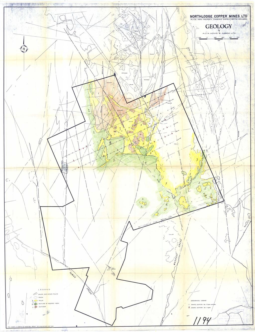
1 NORTHLODOE COPPER MINES LTD. ALICE ARM, B.C. PROPERTY rmwr ON EXPLORATION PROGRAM 1966 OM BEHALF OF G.H.D. CONSULTAWPS LTD. by A. C. A. HOWE & ASSOCIATES LTD. TOROWN), OBITAR10 REPORT NO. 41 A. C. A. HOWE & ASSOCIATES LTD.
2 C O N T E N T S PAGE NO. SUMMARY PRCP ERTY LOCATION AND ACCESS TOPOGRAPHY HT ETOitY WRK DONE DURING 1965 WORK DONE DURING 1966 RESULTS OF GEOCHEMICAL SURVEY RESULTS OF GEOLOGICALPHOTOGEOLOGICAL MAPPING CONCLUSIONS CERTIFICATE APPENDIX: Sample record copies T. S. L. Analysis certificates A. C. A. HOWE & ASSOCIATES LTD.
3 SUMMARY During the 1966 fiela season an exploration program was carried out on the Alice Arm property of Northlodge Copper Mines Ltd. Although minor Pb.,Zn., Cu. mineralization has been reported from some locations on the claim group, no wnes of economic importance have been located. The property does not appear to have any bodies of intrusive rocks around which molybdenum mineralization can be expected. There are no bodies of potentially economic mineralization on the property lying within the limits of detection of the surveys used. No wlditional work is recommended at the presz.-i* +'.
4 The property consists of &Z unpatented mining claims and Mining lease M 89. The claims are listed as follows: CLAIM NAME & NO. REGISTERED NOA CLAIM NAME & NO. REGISTERED NO. Dawn 1 " 2 " 3 " 4 " 5 " 6 " 7 " 8 " 9 " 10 " 12 " 13 " 14 " 15 " 16 " 17 Rupe 1 ' 2 " 3 ' 4 " 5 " 6 " 7 " 8 " 9 " 10 JET I, 6, 7,, 8 I1 9 " 10 Luck 9 " 10 " 11 " 12 " I).._ " 31 " 32 Mining Lease M-89 contains old crown grants L 940, L 3188, L 4260, L 3187, and L 4259 : A. C. A. HOWE & ASSOCIATES LTD.
5 LOCATION AND ACCESS The property lies about nine air miles northeast of the village of Alice Arm. The approximate co-ordinates of the claim group are 55' 33' N, 129' 26' W. Alice Arm can be reached from Prince Rupert by the daily flight of Pacific Western Airways Ltd. The property can be reached via jeep road built from Alice Jbnn ta the YQmrnOnt Mining property at Mount MeGuire. This road passers along the Dak River just south of the boundary of the claim group. The south claims are easily accessible from this road. Access to the north part of the claim group ia dffficu;lf without the aid of 8 helicopter. Alice Ana ha8 population of 12. Supplies lnust be brought in fro= Prfnca Rupert. Alice Arm can be reached from Vancouver by Canadian Pacific lllrlpneagtwice daily flight to Prince Rupert. TotaL flying Sints from Macouver to Alice Arm f s approximatexy four hours. TOPOGRAPHY The property cover. nountalnow eouatry with *%e~tionq + from 900' to 4000'. blost of the area $8.teepa C3O0+) with Zitt e vegetation and soil cover. The Dak River Uom paet tho 8011th end of the property.
6 HI STORK The first prospecting of the Alice Arm area is believed to have been done about The Granby Consolidated Mining, Smelting and Power Company's Hidden Creek Mine, 14 miles south-east of Alice Arm, began production in The Bonanza Mine also belonging to Granby and adjacent to the Hidden Creek Mine, began production about the same time. Both were copper-silver-gold producers. The Dolly Varden Mine was located 15 miles north of Alice Arm. This mine produced silver during the middle and late 1920's. Molybdenite was noted in about 1922 on the Caribou claim group, Lime Creek. It is only within the last seven years that serious consideration has been given to the economic potential of moly+ denite in the area. The Lime Creek deposit is presently being prepared for mining at the rate of 6000 T. P.D. by 7.C. Molyb- denum. Newmont Mining Corporation has carried out extensive investigation of an intrusive body and assoicated mineralized country rock near Mount McGuire. During 1965 and 1966 Highland Bell, Consolidated Mining and melting, Con West, Sileurian Chimfr tan and Canex have been active in the Alice Arm area.
7 WRK DONE DURING 1965 Prospecting exposed several areas showing galena and sphalerite, (Claims Luck 25 & 27, Dawn 6 & 8). Assays of the mineralization returned: 02. % % % Au. Aq. Cu. Pb. MoS2 Tr An undefined amount of trenching in the area.of the lover camp (CG 940) and 'Red Bluffs' (CG 3188, 4620) is reported to have exposed chalcopyrite in four places. An adit in the 'Red Bluffs' was investigated and found to be 35' in length. A series of samples were taken and assayed. SAMPLE 3533 B 3534 B 3535 B 3536 B 02. % % % TYPE WIDTH Au. Ag. Cu. Pb. MoS2 DESCRIPTION Grab High grade dump at adit. Chip 5' Across face of adit. Chip 6' North wall adit. Chip 7' Tr. North wall at portal. The adit is situated on claim CG A small magnetic anomaly (1600 gammas against a back- ground of 900 gammas) was found to be due to a float boulder of magnetite. A character sample (No B) from the boulder as- sayed trace- Au., Ag., 0.40% Cu., trace MoS2 and 67.40% Fe. (Total Fe. ). k C. k HOWE & ASSOCIATES LTD.
8 In arown grant No (nosth-west corner) a quartz breccia vein was sampled. A grab sample (NO B) assayed trace Au., 0.30 oz. Ag., 0.17% Cu., 0.05% Pb., and 0.009% MoS2. A chip sample representing a 3' width of the vein returned: % ms2. Trace Au., 0.15 oz. Ag., 0.09% Cu., 0.05% Pb., and WORK DONE DURING 1966 The program began July 12 when a staff geologist, Mr. B. Mottershead visited the property in order to plan the season's activities. Line cutting and geochemical surveying were carried out along with geological mapping and a photogeolog- ical compilation of the property and the Alice Arm area. RESULTS OF GEOCHEMICAL SURVEY One hundred and eighteen soil samples were collected for molybdenum determinations. These samples were dried in heavy kraft bags,screened through 80 mesh nylon and anakysed spectro- graphically for total Molybdenum. Values are reported in parts per million. Method sensitivity is in the range of P.P.M. betweeb 0.5 and 10 P.P.M. Only thirteen samples showed molyb- denum contents in excess of 0.5 P.P,M. Only two samples, No. 84 (24 P.P.M.) and No P.P.M.) approached anomalous values. A. C. A. HOWE & ASSOCIATES LTD
9 RESULTS OF GEOLOGICAL-PHOMGEOLOGICAL MAPPING The property is underlain by sediments and volcanics of the Hazelton group. This formation on the claim group is composed of mainly flat lying, slightly metamorphosed (green schist facie) volcanic rocks and argillites. Prospecting and mapping failed to show any areasof metamorphosed (Biotite Hornfels) rocks nor any dioritic intrusives such as are the host and source rocks respectively, for molybdenum mineralization in the Alice Arm area. The structural geology of the area, and of the property have been interpreted from the aerial photos and presented on a corrected 1" = 2600' scale base map. There is no evidence of intrusive activity within the claim group although an intrusive is evident north of the Northlodge property in ground presently held by Newrnont. CONCLUSIONS The geochemical survey and geological mapping of the Northlodge Alice Arm property indicate poor prospects for economic Molybdenum or base metal deposits. No geological structures (i.e. dioritic intrusives surrounded by 'halos' of hornfels), favorable for development of Molybdenum deposits are indicated. A geochemical survey of the property showed only two A. C. A. HOWE & AssocI~~~s LTD.
10 .. locations in which the Molybdenum content of the soils approach- ed anomalous levels. The lead-zinc-copper mineralization has not proved to be sufficiently extensive to wmrant additional investigation. RECOMMENDAT IONS No additional work is warranted at the present time. Future work could consist only of detailed magnetic or gravity surveys to locate buried dioritic intrusives. A magnetic sur- vey would be preferred since the cost of topographic control for gravity wrk would be prohibitive, and the accuracy of results in this rugged topography is dubious. Respect fully submitted, A. C. A. HOWE & ASSOCIATES LTD., A. C. A. Howe, P. Eng.
11
12 , Cerlir' 'r! Correct
13
14
15
16
17
18
19
20
21

22
23
24
25
26 DOMINION OF CANADA: PRovlNca OF. BRITISH 1 I Af fidavib in Form "B" filed June 12, 1967 atf fbp &fief. nf by W. F. McGowan rk Jet and Dawn Groups of Mineral Claims, Skeena Mining Division 8, W. F. McGowan, agent for Nadi na Explors.on8 Ltd.,of Vancouver, B. C. in the Province of British Columbia, do solemnly declare that the following is a detailed statement of expenditures involved in line cutting and geochemical sampling, etc.: Linecutting 8$ $ $1,530 Geologist (B. Mottershead) 19 $ ,425 Helper (McDonald) 56 $ ,120 Sampler (Ross) 44 $ Assaying 115 $ Report and map preparation 3 $ Helicopter and servicing i,d88 $6,485 And I make this solemn declaration conscientiously believing it to be true, and knowing that it is of the same force and effect as if made under oath and by virtue of the "Canada Evidence Act." Declared before me at the -4 1 /. in the m+4@&l of ~~~~ Province of British Columbia, this 5-4 day of ~~ / g, A.D. 1 A Cornrnlasioner [or raking Afidavits within British Columhio or m- ~ r i I i s h C d u m b i e,
27
28
Geo chemi c a1 Rep or t SILVER KING FAST GROUP. H. S. Lazenby Geologist. Vancouver, B.C. 16 November 1967
 Geo chemi c a1 Rep or t on SILVER KING FAST GROUP 1967 Vancouver, B.C. 16 November 1967 H. S. Lazenby Geologist Contents Introduction P. 1 Method of Survey P. 1 Interpretation of Results p. L&2 Statement
The MAPLE BAY PROJECT Copper Silver - Gold
 The MAPLE BAY PROJECT Copper Silver - Gold Good grade and tonnage potential within close proximity to Tidewater The Maple Bay Copper Silver Gold Project covers highly favourable geological host rocks of
RECONNAISSANCE GEOCHEMICAL SURVEY
 RECONNAISSANCE GEOCHEMICAL SURVEY LEGAL, RITA, LOUISE FR. (CHAPLEAU GROUP) REVERTED CROWN GRANTS CHAPLEAU CREEK AREAJ, SLOC& MINING DIVISION 82 F/11W Lat: 49'44" Long: 117"22'W MINERAL RESOURCES BRANCH
for the Greenwood Mining Division, B.C. NTS 82E/7W Latitude 49' 27' W, Longitude 118' 5 Prepared by a= D. Dylan Watt, B.Sc.
 t. b LOGnO: 37~ -08 m. ACTIO#: for the AMP AMP 2 AMP 3 t AMP 4 CLAIMS Greenwood Mining Division, B.C. NTS 82E/7W Latitude 49' 27' W, Longitude 8' 5 %E c,w zc *& a w Prepared by a= -4c. D. Dylan Watt, B.Sc.
Work performed between August 1 and December 1, 1975 COMINCO LTD. WESTERN DISTRICT NTS 93 '(~15 EXPLORATION GEOCHEMICAL SURVEY THE CRY AND CAB CLAIMS
 COMINCO LTD. EXPLORATION WESTERN DISTRICT NTS 93 '(~15 GEOCHEMICAL SURVEY ON THE CRY AND CAB CLAIMS CRIN PROPERTY Work performed between August 1 and December 1, 1975 NICHOLAS L. SZABO TABLE OF CONTENTS
BALFOUR MINING LTD. (N.P.L.) HAM GROUP 92-P-6, CLINTON M. D.8 B. C. Lat 51 17'N, GEOCHEMICAL REPORT. V. CUKOR, P. Eng.
 HAM GROUP 92-P-6, CLINTON M. D.8 B. C. Lat 51 17'N, GEOCHEMICAL REPORT. V. CUKOR, P. Eng.") 34q '7 BALFOUR MINING LTD. (N.P.L.) HAM GROUP 92-P-6, CLINTON M. D.8 B. C. Lat 51 17'N, Long 12lo14'W GEOCHEMICAL REPORT, V. CUKOR, P. Eng. January 31, 1972 TABLE OF CONTENTS 1. INTRODUCTION 2. PROPERTY,
34q '7 BALFOUR MINING LTD. (N.P.L.) HAM GROUP 92-P-6, CLINTON M. D.8 B. C. Lat 51 17'N, Long 12lo14'W GEOCHEMICAL REPORT, V. CUKOR, P. Eng. January 31, 1972 TABLE OF CONTENTS 1. INTRODUCTION 2. PROPERTY,
GEOCHEMICAL REPORT THE 82M/12 FH GROUP BIRCH ISLAND, B.C. S1 119O NOW. ROYAL CANADIAN VENTUR 3S LTD. By: Vollo, P. Eng. N.B. Pay 28th, 1969.
 c GEOCHEMICAL REPORT ON THE 82M/12 FH GROUP AT BIRCH ISLAND, BC S1 119O NOW BY ROYAL CANADIAN VENTUR 3S LTD NB By: Vollo, P Eng Pay 28th, 1969 Approximately 700 samples were collected over 14 miles of
NO. MAP..._._..._...,,..,.
 KERR- ADDISON GOLD MINES LIMITED SELF-POTENTIAL SURVEY OWL!i- 12 1 Dwner ) NAOINA 1-4 ) MINERAL CLAIMS W. F. McGowan, ) 3262 Marine Orive, ANGUS 1-4 ) west Vancouver, 8. c. LOCATED AT 5. E. ENO OF OWEN
NEW HAZELTON, OMINECA M.D.,
 PROSPECTING REPORT JUDI 1 TO 6 MINERAL CLAIMS NEW HAZELTON, OMINECA M.D., B.C. MAP 93M/4E, LAT. SS014'N, LONG. 127'33'W OWNED BY: A. L'ORSA ANTHONY L'ORSA Smithers, B.C. 21 February, 1981 TABLE OF CONTENTS
GEOPHYSICAL REPORT. Airborne Magnetometer Survey. of the SHEEP-GOAT GROUP OF MINERAL CLAIMS. near Li l looet, B.C.
 GEOPHYSICAL REPORT 977 Airborne Magnetometer Survey of the SHEEP-GOAT GROUP OF MINERAL CLAIMS near Li l looet, B.C. Lillooet Mining Division (Lat.51 'lot Long. 122 40' 7 5t0[2L05E. for DUFFEY LAKES MINES
GEOCHEMICAL REPORT ON THE YEP CLAIMS, Clinton Mining Division. P.E. Fox, PhD. P.Eng.
 CLNTON 1 MNNG RECORDER GEOCHEMCAL REPORT ON THE YEP CLAMS, Clinton Mining Division P.E. Fox, PhD. P.Eng. Fox Geological Consultants Ltd 204-635 Victoria St. Kamloops, B. C. August 5, 1974 Work done: Juge
12 tons of high-grade ore was mined from the No. 1 vein with an average grade of 13 g/t gold, 3,250 g/t silver and 23.3% lead.
 DUNWELL MINE GROUP The Dunwell Mine Group (Dunwell, Dunwell East, Bear River/MM and Silvershot properties), which includes the historic, past-producing Dunwell mine, is located 8 km northeast of Stewart
RE~ORT ON. J.F.V. MILLAR, P. Eng. GEOCHEMICAL SURVEY TIMBASKET AND MOGUL MINERAL CLAIMS. Kinbasket Lake, B. C. 51 degrees 118 degrees N.E.
 RE~ORT ON GEOCHEMICAL SURVEY TIMBASKET AND MOGUL MINERAL CLAIMS Kinbasket Lake, B. C. 51 degrees 118 degrees N.E. J.F.V. MILLAR, P. Eng. Lease held by J.F.V. MILLAR Work done Sept. 22 - Oct. 3, 1967. REPORT
ASSESShAENT REPORT Mines and Petroleum Resources. Department of. No* JIMMY MINERAL CLAIM FRANKLIN CREEK AREA, GREENWOOD M. D.
 GEOCHEMICAL REPORT ON JIMMY MINERAL CLAIM FRANKLIN CREEK AREA, GREENWOOD M. D. Lat. 49'35' OON, N.T.S. Long. 118O22' 00W 82-E-9 July 18-21, 1974 Vancouver, B.C. J.J. McDougall, P.Eng. July 21, 1974 * Department
ASX Announcement. 28 January Drill results indicate large Porphyry Copper Gold System at Peenam
 ASX Announcement 28 January 2010 Drill results indicate large Porphyry Copper Gold System at Peenam Highlights: 270 metres of visible copper (gold) mineralisation in first diamond core hole at Peenam Prospect
.April 3, Jon G. Baird, B.Sc., P.Eng. LOCATION : One mile west of Mile 70 on the Haynes Road At lin Mining Division 135" 59 O SE
 , It I i REPORT ON MAGNETIC AND ELECTROMAGNETIC SURVEYS ON SOME LUNAR CLAIMS NADAHINI MOUNTAIN AREA NORTHERN BRITISH COLUMBIA ON BEHALF OF MAX FUERSTNER AND IRWIN DEFT 1 t Jon G. Baird, B.Sc., P.Eng..April
PRECIOUS METALS. owner. JMT Services Corp. GEOCHPlICAL SAMPLING CHELASLIE WCE, NORTH CENTRAL, B.C. OMINECA MINING DIVISION NTS 93F/5E & 6W
 PRECIOUS METALS REPORT ON 1980 RECONNAISSANCE GEOCHPlICAL SAMPLING CHELASLIE WCE, NORTH CENTRAL, B.C. OMINECA MINING DIVISION NTS 93F/5E & 6W LATITUDE 53O28 N LONGITUDE 125O31 W DATES Qp WORK: JULY 10
UNION MINIERE EXPLORATIONS AND MINING CORPORATION LIMITED ASSESSMENT REPORT ON FITINAT MINERAL CLAIM. Alberni Mining Division Record No.
 M F )( UNION MINIERE EXPLORATIONS AND MINING CORPORATION LIMITED Suite 200, 4299 Canada Way, Burnaby, B.C. V5G 1 H4 Telephone (604) 437-9491 ASSESSMENT REPORT ON GEOCHEMICAL SOIL SURVEYS AND ROCKSAMPLING
- LONGITUDE : 128'06 'W
 COMINCO LTD. WESTERN DISTRICT MARCH 1977 SOIL GEOCHEMICAL SURVEY SAND 1 and SAND 2 CLAIMS HIDDEN VALLEY AREA LIARD MINING DIVISION LATITUDE : 59'03' - LONGITUDE : 128'06 'W JUNE 20/76-JULY 12/76 REPORT
SECOND and THIRD YEAR ASSESSMENT REPORT PROSPECTING LICENCE M, ROCK CUT PROPERTY, NTS 1N/12, NEWFOUNDLAND. ROY FRENCH (licence holder )
") SECOND and THIRD YEAR ASSESSMENT REPORT Of PROSPECTING On LICENCE 013704M, ROCK CUT PROPERTY, NTS 1N/12, NEWFOUNDLAND. By ROY FRENCH (licence holder ) Work Conducted: Sept. 17, 2008 Nov. 03, 2009 Total
SECOND and THIRD YEAR ASSESSMENT REPORT Of PROSPECTING On LICENCE 013704M, ROCK CUT PROPERTY, NTS 1N/12, NEWFOUNDLAND. By ROY FRENCH (licence holder ) Work Conducted: Sept. 17, 2008 Nov. 03, 2009 Total
CONSULTING GEOLOGICAL & MINING ENGINEERS 1000 GUINNESS TOWER VANCOUVER I, B.C. GEOCHEMICAL AND GEOLOGICAL RE PORT
 DOLMAGE CAMPBELL & ASSOCIATES LTD. CONSULTING GEOLOGICAL & MINING ENGINEERS 1000 GUINNESS TOWER VANCOUVER I, B.C. GEOCHEMICAL AND GEOLOGICAL RE PORT on RAVEN MINERAL CLAIMS Nos. 1-10 and 17-21 Claim Sheet
The Cobalt Rainbow. Airborne geophysical maps show that a north trending aeromagnetic high suggests further undiscovered mineralisation.
 The Cobalt Rainbow The property is located on Greenstone Creek, approximately 4.8 kilometres south west of the creek mouth. The property is located about 24 km due west of Campbell River, in the east-central
0.. HUDSON BAY EXPLORATION AND DEVELOPMENT COMPANY LIMITED OMINECA MINING DIVISION BRITISH COLUMBIA REPORT ON EXPLORATION PROGRAM
 'I '0; 63 HUDSON BAY EXPLORATION AND DEVELOPMENT COMPANY LIMITED LSD CLAIM PROPERTY OMINECA MINING DIVISION Q. i!' p BRITISH COLUMBIA REPORT ON EXPLORATION PROGRAM - 972 BY R. A. FREBERG, P. ENG. SEPTEMBER
1 FILMED 1. FILE NO:!..rsrru -* -. GRAND TWO CLAIM
 FILE NO:!..rsrru -* -. GRAND TWO CLAIM REPORT ON 1993 ASSESSMENT WORK GRAND TWO CLAIM REC. NO. 301849 NELSON MINING DIVISION NTS MAP SHEET 82F6/W 49 25'51" NORTH 117 18'08" WEST 1 FILMED 1 AUTHOR: R. Jordan,
PROSPECTING REPORT THE WALLACE CLAIM OMENICA MINING DIVISION. 54" x6" 3.d d. for. Reako Exlorat ions Ltd. Wallace Rev. C.G.
 PROSPECTING REPORT ON THE WALLACE CLAIM OMENICA MINING DIVISION 54"44 14 1x6" 3.d d by David A. Howard P.Eng. for Reako Exlorat ions Ltd. Claim Locat ion Wallace Rev. C.G. #1560 Dome Mountain Area 9 3
for the Greenwood Mining Division, B.C. NTS 82E/7W 29' W, Longitude 118' 53' N Prepared by D. Dylan Watt, B.Sc.
 for the FltE NO: u VOLT 1, VOLT 2, VOLT 3, & VOLT 4 CLAIMS Greenwood Mining Division, B.C. NTS 82E/7W Latitude 49' 29' W, Longitude 118' 53' N Prepared by D. Dylan Watt, B.Sc. #309-1996 Trutch Street Vancouver,
GRISWOLD CREEK, B.C. 6 " GEOCHJ3lICAL REPORT
 GRISWOLD CREEK, B.C. 6 " GEOCHJ3lICAL REPORT AUTROR: W. Meyer, BSc. ENDORSED El!: John De Leen, BASc.* NASc., E.M., P. Eng. No. 3675 Vancouver, B.C. January 22nd, 1965. -I- During the period of July 27th
Lat. 52' 43' N Long ' W
 &A exploration ltd MINING ENGINEERING GEOLOGY- GEOPHYSICS 4570 HOSKINS ROAD, NORTH VANCOUVER, 6. C. TELEPHONE (804) 985,7921 V7K 2R1 GEOLOGICAL AND GEOCHEMICAL REPORT on the BLUE CLAIMS Cariboo Mining
TOPOGRAPHICAL SURVEY REPORT ON THE GREENDROP PROPERTY NEAR CHILLIWACK, B.C. 92-H-3/W
 TOPOGRAPHICAL SURVEY REPORT ON THE GREENDROP PROPERTY NEW WESTMINSTER M.D. NEAR CHILLIWACK, B.C. 92-H-3/W Location: The central pap of the claims is located at coordinates 49 08'N, latitude by 121 26'W,
T'he Horn property comprises a group of forty. contiguous claims owned by Canadian Superior Exploration
 -1- INTRODUCTION T'he Horn property comprises a group of forty contiguous claims owned by Canadian Superior Exploration Limited. The group is located five miles nort'h of Motase Lake. In July and August,
Serengeti Resources Inc GEOCHEMICAL REPORT ON THE SHADOW PROPERTY a.
 Serengeti Resources Inc. 2004 GEOCHEMICAL REPORT ON THE SHADOW PROPERTY a. Located in the Johanson Lake Area Omenica Mining Division NTS 94D/9 6 degrees and 32 minutes North Latitude 126 degrees and 2
REPORT SOIL GEOCHEMICAL SURVEY. ATTYCELLEY NO. 2 GROUP (Attycelley Mineral Claims No. 7-10)
") REPORT SOIL GEOCHEMICAL SURVEY ATTYCELLEY NO. 2 GROUP (Attycelley Mineral Claims No. 7-10) Situated 7 miles east of north end of Thutade Lake, Omineca Mining Division British Columbia I Department of I
REPORT SOIL GEOCHEMICAL SURVEY ATTYCELLEY NO. 2 GROUP (Attycelley Mineral Claims No. 7-10) Situated 7 miles east of north end of Thutade Lake, Omineca Mining Division British Columbia I Department of I
SAMPLE ID SAMPLE TYPE Au (g/t) Ag (g/t) Cu (%) AuEq**(g/t)
 Ag (g/t) Cu (%) AuEq**(g/t)") GOLDEN RIDGE RESOURCES DISCOVERS NEW ALKALIC CU-AU PORPHYRY TARGET ON ITS HANK PROJECT Kelowna, British Columbia November 22,2017 - Golden Ridge Resources Ltd. ( Golden Ridge or the Company ) (TSXV: GLDN).
GOLDEN RIDGE RESOURCES DISCOVERS NEW ALKALIC CU-AU PORPHYRY TARGET ON ITS HANK PROJECT Kelowna, British Columbia November 22,2017 - Golden Ridge Resources Ltd. ( Golden Ridge or the Company ) (TSXV: GLDN).
Goliath Reports Grams Per Tonne Gold Equivalent Over 2 Metres Channel Cut at Golddigger in the Golden Triangle; Bulk Sample Recommended
 Goliath Reports 22.83 Grams Per Tonne Gold Equivalent Over 2 Metres Channel Cut at Golddigger in the Golden Triangle; Bulk Sample Recommended November 28, 2017 Goliath Resources Ltd. (TSX-V: GOT) (the
POTENTIAL OF THE DONGWE COPPER GOLD PROJECT
 POTENTIAL OF THE DONGWE COPPER GOLD PROJECT By Nathan Sabao, P.Geo. September 2015 1 TABLE OF CONTENTS Page 1.0 EXECUTIVE SUMMARY 1 2.0 LOCATION 2 3.0 ACCESS 2 4.0 GEOLOGY 3 5.0 PREVIOUS DRILLING 5 6.0
Drilling program commences on Cloncurry and Mount Isa projects
 1P P May UASX/Media Announcement st 2009 Drilling program commences on Cloncurry and Mount Isa projects Key Points 1,700 metres reverse circulation drilling program over two prospects on untested geochemical,
A PRELIMINARY REPORT ON THE ZYMOST2 CLAIM GROtP, TERRACE, B.C.
 NATIVE EXPLORATIONS LTD. A PRELIMINARY REPORT ON THE ZYMOST2 CLAIM GROtP, TERRACE, B.C. INTRODUCTION': The Zymoetz claim group is, at present, held under option by Native Explorations Ltd.. On the 19th
GEOLOGICAL MAPPING REPORT ON THE ASH MINERAL CLAIM OSOYOOS MINING DIVISION ASHNOLA RIVER MAP SHEET NTS M092,H019 MCBRIDE CREEK AREA, ASHNOLA RIVER,
 GEOLOGICAL MAPPING REPORT ON THE ASH MINERAL CLAIM OSOYOOS MINING DIVISION ASHNOLA RIVER MAP SHEET NTS M092,H019 LATITUDE 49 o O6, LONGITUDE 120 o 22 MCBRIDE CREEK AREA, ASHNOLA RIVER, KEREMEOS, B.C. CANADA
The SL group is located 10 miles east of Lac La Hache and can be reached by good secondary roads.
 0 Summary Soil samples were collected and analyzed for trace mercury vapour content over a magnetic and electromagnetic anomaly. Weak positive evidence of base metal mineralization was obtained. Location
ASSESSMENT REPORT GEOLOGICAL BRANCH. 50' 23 'North. GEOLOGICAL and GEOCHEMICAL SURVEYS ON THE. PUTNAM PROPERTY (Putnam Mineral Claim)
") GEOLOGICAL and GEOCHEMICAL SURVEYS ON THE PUTNAM PROPERTY (Putnam Mineral Claim) VERNON MINING DIVISION, B.C. GEOLOGICAL BRANCH ASSESSMENT REPORT NTS : Latitude: 82L17W 50' 23 'North LOCATION, ACCESS,
GEOLOGICAL and GEOCHEMICAL SURVEYS ON THE PUTNAM PROPERTY (Putnam Mineral Claim) VERNON MINING DIVISION, B.C. GEOLOGICAL BRANCH ASSESSMENT REPORT NTS : Latitude: 82L17W 50' 23 'North LOCATION, ACCESS,
T-1 Mines and Petroleum Resources
 Department of T-1 Mines and Petroleum Resources ASSESSfdEEdT REPORT NO..LC... 7.t... hlap... ... NTRODUCTON Y ' PERSONNEL.... GEOGRAPHY.... Location..... Access... Page 1 Page 2 Page 2 Page 2 Page 2 Topography...
CONTENTS. Location, Access and History...6. Tenure Status and Geology Regional Andy Property Geology Map...9
 TYPE OFWORK IN THIS REPORT EXTENT OF WORK (rn METRTC UNITS) ON WHICH CLAIMS PROJECT COSTS APPORTIONED (incl. support) GEOLOGICAL (scale, area) Ground, mapping Photo interpretation GEOPHYSICAL (line-kilometres)
GOLDCLIFF TULAMEEN PORPHYRY COPPER PROJECT COPPER MOUNTAIN CAMP, BRITISH COLUMBIA THE TROJAN-CONDOR COPPER TARGET HIGHLIGHTS
 Suite 350-885 Dunsmuir Street PF 250 764 8879 TF 866 769 4802 Vancouver, BC, Canada FX604 261 8994 info@goldcliff.com V6C 1N5 GCN.TSXV www.goldcliff.com GOLDCLIFF TULAMEEN PORPHYRY COPPER PROJECT COPPER
PROSPECTORS ASSISTANCE PROGRAM MINISTRY OF ENERGY AND MINES
 BRITISH COLUMBIA PROSPECTORS ASSISTANCE PROGRAM MINISTRY OF ENERGY AND MINES GEOLOGICAL SURVEY BRANCH PROGRAM YEAR: 1999/2000 REPORT #: PAP 99-l 6 NAME: KIM ANSCHETZ PROSPECTORS TlEPORT on the 99 LOUIS
ASX / MEDIA RELEASE 6 MAY MILE SILVER-LEAD-ZINC DISCOVERY; HIGH GRADE SILVER-GOLD IN ROCK CHIPS AT RUBY SILVER
 ASX / MEDIA RELEASE 6 MAY 2011 4-MILE SILVER-LEAD-ZINC DISCOVERY; HIGH GRADE SILVER-GOLD IN ROCK CHIPS AT RUBY SILVER Highlights: Silver-lead-zinc discovery at 4-Mile; mineralisation intersected in all
CSA Mine Observations Applied to the Development of Regional Exploration Models
 CSA Mine Observations Applied to the Development of Regional Exploration Models 1 Introduction Recent work completed by the geology team has resulted in an improved understanding of the CSA mine system
EXPLORATION and DEVELOPMENT REPORT. Conrad Creek. PLACER and MINERAL CLAIMS SOUTHEAST BRITISH COLUMBIA
 EXPLORATION and DEVELOPMENT REPORT on Conrad Creek PLACER and MINERAL CLAIMS in SOUTHEAST BRITISH COLUMBIA Ed Friesen, BSc.E.E., P. Eng 8 Lake Placid Rise SE Calgary, Alberta T2J 5B5 April 2009 1 P age
Pacific Empire Minerals Provides Copper King RC Drilling Results
 Pacific Empire Minerals Provides Copper King RC Drilling Results November 1, 2018 - Vancouver, BC, Canada - Pacific Empire Minerals Corp. (TSXV: PEMC) ( Pacific Empire, PEMC or the Company ), a hybrid
HOWE COPPER MINE PROJECT HIGH GRADE Cu-Ag with Au
 HOWE COPPER MINE PROJECT HIGH GRADE Cu-Ag with Au The Howe Copper Mine property is located approximately 55 kilometres northwest of Vancouver, BC. It is situated at 1431 metres elevation on the eastern
GEOCSZNICAL - SURVEY. ICAMLOOPS Kl.D. 2'' 6;kr. HY "'f. Alfred R. Allen,P.Eng. 1 NO.%=...,... 6"- 'I.
 t i.i GEOCSZNICAL - SURVEY i p' ICAMLOOPS Kl.D. 2'' 6;kr HY 50-64 +."'f 121-51 NE 5-10-70 : 19-10-70 Alfred R. Allen,P.Eng. I) ' 1 6"- 'I. 1 NO.%=...,..... Q.C. EXPLORATIONS LTD. 2Cl- 535 Kowe Street Vancouver
sq N & %%.& GEOPHYSICAL CONSULTING rr SERVICES LTD. $%& Long. 118o3OtW N.T.S. 82 E/15 -I- AUTROR: Glen E. Whi*e, B.Sc., P. %g.
 -\ GEOCHEMICAL EXPORT.,~.,~..'.. AMORE MINERALS 1NCORPOR;ITZC,' ~. 3rd fl5 Geo 3. and 2 mineral claims, Vernon- ~ $lining Division, B. C. Lat. 49 47'T?,,/ Long. 118o3OtW N.T.S. 82 E/15 -I- AUTROR: Glen
J.D. Mason, Prof. Engineer. Report on the Reconnaissance Magnetometer Survey. Completed for. North American Platinum Corporation Ltd.
 Report on the Reconnaissance Magnetometer Survey Completed for North American Platinum Corporation Ltd. Olivine Mountain Property, Tulameen, B.C. J.D. Mason, Prof. Engineer. November 28, 1967. Certificate
Tameapa Regional Geology
 Tameapa Project 1 Tameapa Regional Geology History San Francisco Mines of Mexico Ltd. (San Francisco), which completed an exploration program, including six drill holes (1,157 m) between 1956 and 1959.
The Gold Hill s Big Chief Showing. Cross Section Line A-A' (Pighin 2014)
") GOLD HILL SUMMARY In 1864 gold fever struck in the south Kootenays east of Cranbrook, British Columbia as placer gold was discovered in the Wild Horse River. What followed was everything one can imagine
GOLD HILL SUMMARY In 1864 gold fever struck in the south Kootenays east of Cranbrook, British Columbia as placer gold was discovered in the Wild Horse River. What followed was everything one can imagine
NICOLA M.D King Street West, April, 1969 AMALG 1-44 MINERAL CLAIMS 1. OWNER: Dr. F. R. Burton, W. M. Sirola, P. Eng.
 REPORT ON ' MAGNETIC AND ELECTROMAGNETIC SURVEY AMALG 1-44 MINERAL CLAIMS 1. NICOLA M.D. 49'501 N - 12Oo57f W OWNER: Dr. F. R. Burton, 1506-44 King Street West, Toronto 1, Ontario. by W. M. Sirola, P.
GEOLOGICAL- GEOPHY S ICAL- GEOCHEMICAL REPORT. on the KLI MINERAL CLAIMS KLIYUL CREEK AREA. Located 12 miles west of Aiken Lake, B. C.
 GEOLOGICAL- GEOPHY S ICAL- GEOCHEMICAL REPORT on the KLI MINERAL CLAIMS KLIYUL CREEK AREA Located 12 miles west of Aiken Lake, B. C. (56' 27' N, 126" 051 W) 94 3 ] g ~ Omineca Mining Division, B. C. G.
 ..m,"f.k*"--v- A tot,al of 18 line miles of magnetometer surveying was completed on the "B" and "J" claim groups during August of 197. Approximately two-thirds of the area covered by the survey is glaciated,
Narrow High-Grade Gold and Long Low-Grade Porphyry Gold and Copper-Gold Intercepts at Bulago
 CONTACTS PHONE EMAIL PO Box 52 +61 (08) 9295 0388 info@frontierresources.com.au West Perth FAX WEBSITE WA 6872 Australia +61 (08) 9295 3480 www.frontierresources.com.au ASX Limited Company Announcements
Mountain Maid Gold System Displays Major Size Potential
 29 July 2008 The Manager, Companies Australian Securities Exchange Ltd Electronic Announcement System Dear Sir, AXIOM MINING LIMITED (ASX CODE: AVQ) ASX Announcement Mountain Maid Gold System Displays
Haoma Mining NL A.B.N
 Haoma Mining NL A.B.N 12 008 676 177 Registered Office & Head Office: 411 Collins Street, Melbourne, Vic., 3000, GPO Box 2282U, Melbourne, Vic., 3001. Telephone (03) 9629 6888, Facsimile (03) 9629 1250
1 CLAIMS GEOPHYSICAL REPORT ON BOYAL SITUATE NORTHEAST OF TILLICUM MOUNTAIN GOLD AREA BURTON - NAKUSP SIQCAEJ MINING DIVISION
 GEOPHYSICAL REPORT ON BOYAL 1 CLAIMS SITUATE NORTHEAST OF TILLICUM MOUNTAIN GOLD AREA BURTON - NAKUSP SIQCAEJ MINING DIVISION CONSULTING GEOLOGIST AUGUST 1983 VANCOUVER B *C INDEX INTRODUCTION ooa,.eoaaa.aaaoaaooaoa~ao~o
for June 21, 1978 John R. Poloni, B. Sc., Poloni and A ssociates Ltd., B Avenue, Delta, B.C. REPORT ON THE UNITED VERDE MINE
 REPORT ON THE UNITED VERDE MINE NELSON MINING DIVISION for BENSON MINES LTD. by John R. Poloni, B. Sc., P. Eng. June 21, 1978 John R. Poloni and A ssociates Ltd., 5502-8B Avenue, Delta, B.C. 7300 JOHN
Queensland Mining Corporation Limited
 Queensland Mining Corporation Limited ABN 61 109 962 469 ASX Release 29 th July 2011 Drilling Commenced at Duck Creek Copper-Gold Project, Cloncurry, North-west Queensland Highlights RC drilling has commenced
NTS 93L/9W GEOCHEMICAL AND GEOPHYSICAL REPORT MONA CLAIM OMINICA MINING DIVISION. Lati tude 54036'N; Longitude 'W
 GEOCHEMICAL AND GEOPHYSICAL REPORT ON MONA CLAIM OMINICA MINING DIVISION Lati tude 54036'N; Longitude 126018'W NTS 93L/9W April 1981 Paul Plicka Consulting Geologist LOCATION MAP INTRODUCTION TABLE OF
lat ' N Long ' W
 305 7 ec1;, REPORT ON THE JERY CLAIMS OF POLA RESOURCES LTD. NTS 93L/16 0 0 lat. 54 45' N Long. 126 22' W BABIXE LAKE AREA OMINECA MINING DIVISION, B.C. PAUL PLICKA CONSULTING GEOLOGIST DECEMBER 30, 1981
GEOLOGY AND LITHOGEOCHEMISTRY OF THE CHILKO-TASEKO LAKES AREA* BY G.
 B Ministry of Energy, Mines and Petroleum Resources GEOLOGICAL BRANCH MINERAL RESOURCES DIVISION NOTES TO ACCOMPANY OPEN FILE - GEOLOGY AND LITHOGEOCHEMISTRY OF THE CHILKO-TASEKO LAKES AREA* BY G. P. McLAREN
BRITISH NEWFOUNDLAND EXPLORATION LIMITED PROSPECTING REPORT JR AND MARK CLAIMS LIARD MINING DIVISION, B. C. By: Michael G.
 BRITISH NEWFOUNDLAND EXPLORATION LIMITED PROSPECTING REPORT JR AND MARK CLAIMS LIARD MINING DIVISION, B. C. By: Michael G. Willia 6- "t f I - -- ---- --.--. Department af I Brinex Report No. ~74546,- NTS
SUMMl'l WlLS LIU. GEOPHYSICAL REPORT. W. CT. a~evenson Y I
 SUMMl'l WlLS LIU. GEOPHYSICAL REPORT W. CT. a~evenson Y3 qi@, 1970. I 2-90 9 CONTENTS - PAGE Introduction... 1 Property... 1 Location and Access... 1 Survey Specifications Survey Grid... 1 Induced Polarization
Kalimantan Gold Corporation Limited
 Kalimantan Gold Corporation Limited BAROI PROSPECT Far Eastern Zone High-Grade Copper Silver Gold October 2003 Baroi Prospect Far Eastern Zone High-Grade Copper Silver Gold Introduction Today KGC have
..!I AXE CLAIMS ON THE. for RICHCORE EXPLORATIONS LTO. GREENWOOD MINING DIVISION BRITISH COLUMBIA. Latitude 49O 30"; Longitude 118' 30'W NTS 82E/9W
 ON THE AXE CLAIMS for RICHCORE EXPLORATIONS LTO. GREENWOOD MINING DIVISION BRITISH COLUMBIA Latitude 49O 30"; Longitude 118' 30'W NTS 82E/9W... -... ~ i.,...._.'..!i Vancouver, B.C. September, 1980 P.
BLURTON CREEK NICKEL PROPERTY. (Minfile # 082LNW-039)
") 5489153 BLURTON CREEK NICKEL PROPERTY (Minfile # 082LNW-039) Mara Lake Area / Salmon Arm B.C NTS - 82L-11 (UTM 83/Z10, 357690E, 5614220N) Prepared by: Jim Cuttle, B.Sc., P.Geo. 86 Cloudburst Road Whistler,
5489153 BLURTON CREEK NICKEL PROPERTY (Minfile # 082LNW-039) Mara Lake Area / Salmon Arm B.C NTS - 82L-11 (UTM 83/Z10, 357690E, 5614220N) Prepared by: Jim Cuttle, B.Sc., P.Geo. 86 Cloudburst Road Whistler,
102 metres strike length averaging 32.62g/t Gold extends overall surface vein sampling to date to 726 metres strike length averaging 24.
 ASX ANNOUNCEMENT / MEDIA RELEASE ASX:ABU 8 th February 2012 Old Pirate Phase 4 Longitudinal Trenching Results for veins on the Western Limb Lodes 102 metres strike length averaging 32.62g/t Gold extends
CHIVAS A New Large Scale Au-Ag-Te-Cu Target
 Northwest British Columbia April 4, 2017 CHIVAS A New Large Scale Au-Ag-Te-Cu Target The Kamloops Exploration Group 2017 30 YEARS OF DISCOVERY 1 Gary R. Thompson, P.Geo. SAFE HARBOUR STATEMENT Information
on the SALAL CREEK MOLYBDENUM PROPERTY, SALAL CREEK, B.C. LILLOOET MINING DIVISION, BRITISH COLUMBIA
 on the J PLUG 9-12, PLUG 19-24, BAT 10-14, BAT 15 Fr., BAT 16 Fr. MINERAL CLAIMS, SALAL CREEK MOLYBDENUM PROPERTY, SALAL CREEK, B.C. LILLOOET MINING DIVISION, BRITISH COLUMBIA N.T.S. 92 J 14 LATITUDE 50
DISCOVERY OF MINERALISED PORPHYRY & MAGNETITE-COPPER-GOLD AT KAMARANGAN
 MEDUSA MINING LIMITED ABN: 60 099 377 849 Unit 7, 11 Preston Street Como WA 6152 PO Box 860 Canning Bridge WA 6153 Telephone: +618-9367 0601 Facsimile: +618-9367 0602 Email: admin@medusamining.com.au Internet:
49" 3-4 I4 I \ Y 59 tj
 ASSESSMENT REPORT Mary 4 FORT STEELE M.D. NTS 82G/5W 49" 3-4 4 \ Y 59 tj Owner: St. Eugene Mining Corporation Limited Operator : St. Eugene Mining Corporation Limited Author: John R. Wilson Date Submitted:
LINGIG PORPHYRY COPPER DISCOVERY
 MEDUSA MINING LIMITED ABN: 60 099 377 849 Unit 7, 11 Preston Street Como WA 6152 PO Box 860 Canning Bridge WA 6153 Telephone: 618-9367 0601 Facsimile: 618-9367 0602 Email: admin@medusamining.com.au Internet:
CARIBOO - GRIZZLY ZINC PROJECT
 CARIBOO - GRIZZLY ZINC PROJECT The Grizzly Lake or Cariboo Zinc property straddles the gravel Weldwood 8400 logging road in the Grizzly Lake area about 55 kilometres northeast of Likely. Roads constructed
Prospecting Report 'S Office i DB Property, B.C. -J Negro Creek Nelson Mining District NTS 82F.050. Operator: Kootenay Gold Inc.
 . '.' I"' i9 12 Prospecting Report 'S Office i DB Property, B.C. -J Negro Creek Nelson Mining District NTS 82F.050 Operator: Kootenay Gold Inc. Owner: Darlene Lavoie Work Performed Summer of 2007 Report
Fletcher Junction Project Technical Update December 18, 2008
 Fletcher Junction Project Technical Update December 18, 2008 Disclaimer Warning! The business of Gold Exploration can be FUN, but it can also be hazardous to your physical, emotional, spiritual and financial
27 metres Grading 66.8 g/t Gold and
 ADDRESS PHONE EMAIL PO Box 35 +61 (8) 9295 0388 info@frontierresources.com.au North Perth FAX WEBSITE WA 6906 Australia +61 (8) 9295 3480 www.frontierresources.com.au ASX Limited Company Announcements
REPORT ON MAGNETOMETER SURVEY TIK-1 CLAIM e&f KAMLOOPS MINING DTVISION. by D. Hendry D. C. MILLER. February 3, for
 REPORT ON MAGNETOMETER SURVEY TIK-1 CLAIM 92-1-14 e&f KAMLOOPS MINING DTVISION lat. 50 57 ' 12" long. 121O23 ' 37" OWNER: ST. JOSEPH EXPLORATIONS LIMITED OPERATIOR: ST. JOSEPH EXPLORATIONS LIMITED by D.
Altan Nar. Gold & Base Metal Discovery (Tsenkher Nomin Property) October 12 th, 2011
 October 12 th, 2011") Altan Nar Gold & Base Metal Discovery (Tsenkher Nomin Property) October 12 th, 2011 1 FORWARD-LOOKING STATEMENTS Certain information regarding Erdene ("the Company") contained herein may constitute forward-looking
Altan Nar Gold & Base Metal Discovery (Tsenkher Nomin Property) October 12 th, 2011 1 FORWARD-LOOKING STATEMENTS Certain information regarding Erdene ("the Company") contained herein may constitute forward-looking
4. Geological maps published by the Ontario Department of Mines.
 52J08NWei45 S2J08NWa6B1 SMYE 010 AMALGAMATED RARE EARTH MINES LTD. *, SAVANT LAKE PROSPECT x ONTARIO INTRODUCTION t This Is a report on a group of 28 claims control led by Amalgamated Rare Earth Mines
For personal use only
 ANNOUNCEMENT TO THE AUSTRALIAN SECURITIES EXCHANGE: 28 NOVEMBER 2012 DRILLING UPDATE MABILO PROJECT The Directors of Sierra Mining Limited ( Sierra ) are pleased to announce further results from reconnaissance
ASSESSMENT REPORT ON THE PEAVINE PROJECT. DGW & Associates # Alberni Street, Vancouver, British Columbia, V6E 4V2
 ASSESSMENT REPORT ON THE PEAVINE PROJECT KAMLOOPS MINING DIVISION BRITISH COLUMBIA NTS 082M 12 Latitude 51 36' 19.0"North -- Longitude --119 47' 27.0"West UTM Zone 11, NAD 83 5720827N 306744E Prepared
epartment 0,' REPORT ON MAGNETIC AND ELECTROMAGNETIC SURVEYS ANYOX AREA, BRITISH COLUMBIA ON BEHALF OF BOW RIVER RESOURCES LTD.
 --- epartment 0,' REPORT ON MAGNETIC AND ELECTROMAGNETIC SURVEYS ANYOX AREA, BRITISH COLUMBIA ON BEHALF OF BOW RIVER RESOURCES LTD. Michael J. Lewis, M.Sc. and Peter J. Fominoff, B.A.Sc. August 15, 1972
GEOPHYSICAL REPORT THE CAVZ CLAIMS
 GEOPHYSICAL REPORT Magnetometer Survey on THE CAVZ CLAIMS CAVZ M.C.'s 1 to 12, 15 to 26, 29 to 40, 45 to 54 Trail Peak, Omineca M.D. 13 miles northeast of Fort Babine 550 ) 126 S.E. by G.Podolsky J.Russell
Cominco ltd. REPORT OF GRID "C" GEOCHEMICAL SURVEY ON VINE 1 CLAIM, VINE 1, 25, 27 CLAIM GROUP Fort Steele Mining Division
 GOVERNMENT OFFICE Cominco ltd. EXPLORATION DIVISION REPORT OF GRID "C" GEOCHEMICAL SURVEY ON VINE 1 CLAIM, VINE 1, 25, 27 CLAIM GROUP Fort Steele Mining Division Submitted by: E.W. BATCHELOR Cominco Ltd.
ASSESSMENT REPORT MAGNETOMETER SURVEY GOLDEN ROD, GOLDEN ROD #2. Long.: General Delivery, Vananda, B. C.
 ASSESSMENT REPORT MAGNETOMETER SURVEY GOLDEN ROD, GOLDEN ROD #2 t=/ NTS 92~110w Lat.: Long.: 49O 44' N 124O 34' W Owner: E. Johanson General Delivery, Vananda, B. C. Operator: Rhyolite Resources I nc.
JV Project Portfolio Executive Summary: Bruce Smith
 JV Project Portfolio Executive Summary: Bruce Smith September 5, 2012 Disclaimer Forward-Looking Statements This presentation contains forward-looking statements, including but not limited to comments
entire 1.5 meter drift width
 GOLD HILL SUMMARY In 1864 gold fever struck in the south Kootenays east of Cranbrook, British Columbia as placer gold was discovered in the Wild Horse River. What followed was everything one can imagine
IVANHOE MINES LTD ACQUIRES FOUR NEW COPPER-GOLD PROJECTS IN MONGOLIA
 News Release October 15, 2001 IVANHOE MINES LTD ACQUIRES FOUR NEW COPPER-GOLD PROJECTS IN MONGOLIA SINGAPORE - Ivanhoe Mines Chairman Robert Friedland and Senior Vice-President, Exploration, Douglas Kirwin
GEOCMCAL SURVEY LOOP PROPERTY NCRAIIDA EXPLORATION COMPANY, LIMITED OMINECA MINING DIVISION JULY 5, 1971 TO JULY 30, 1971
 GEOCMCAL SURVEY LOOP PROPERTY NCRAIIDA EXPLORATION COMPANY, LIMITED OMINECA MINING DIVISION JULY 5, 1971 TO JULY 30, 1971 TABLE OF CONTENTS INTRODUCTION 2 li Fig. A (Incation Map) GENERAL GEOLOGY GRID
SPL 1452 NAMOLI & WAINIVAU GOLD AND COPPER PROSPECTS
 SPL 1452 NAMOLI & WAINIVAU GOLD AND COPPER PROSPECTS (Multiple Namosi-like Exploration Targets) SPL1452 being contiguous with the Namosi SPL1420 owned by the Newcrest Joint Venture and with the same type
490 20' 30" North Latitude ' 30" West Longitude
 _._.. I CONSULTING GEOLOGISTS 605-602 WEST HASTINGS STREET, VANCOUVER, B.C. V6B 1P2 TELEPHONE: (604) 689-5533 6 I F: ASSESSMENT REPORT ON THE PATSY 1 MINERAL CLAIM ' '?%2% I WHISTLE CREEK, HEDLEY ARE L-l-
SQUARE POST PROJECT CHARTERS TOWERS NORTH QUEENSLAND AUSTRALIA
 SQUARE POST PROJECT CHARTERS TOWERS NORTH QUEENSLAND AUSTRALIA Square Post - Summary PROJECT DETAILS - SQUARE POST The Square Post exploration permit (EPM 18510) contains two styles of mineralisation:
Elephant Mountain, Alaska Intrusive Related Gold Project July Option to Earn 100%
 Elephant Mountain, Alaska Intrusive Related Gold Project July 2018 Option to Earn 100% CORPORATE Corporate DISCLOSURE Disclosure The information contained herein, while obtained from sources which we believe
News Release No GOLD AND COPPER MINERALIZATION DISCOVERED DURING PHASE 2 EXPLORATION AT THE MCBRIDE PROPERTY
 November 19, 2018 TSX Venture Exchange Listed Frankfurt Exchange Listed News Release No. 303-2018 GOLD AND COPPER MINERALIZATION DISCOVERED DURING PHASE 2 EXPLORATION AT THE MCBRIDE PROPERTY Vancouver,
2013 GEOLOGICAL ASSESSMENT REPORT SHERIDAN HILL PROPERTY
 2013 GEOLOGICAL ASSESSMENT REPORT ON THE SHERIDAN HILL PROPERTY NEW WESTMINSTER MINING DIVISION BRITISH COLUMBIA NTS 092G07 49 16 31 NORTH LATITUDE, 122 39 48 WEST LONGITUDE PREPARED FOR Sheridan Hill