TAQA Bratani Ltd. TAQA BRATANI LTD. P1995 RELINQUISHMENT DOCUMENT
|
|
|
- Nicholas Marshall
- 6 years ago
- Views:
Transcription
1 TAQA BRATANI LTD. P1995 RELINQUISHMENT DOCUMENT
2 Contents 1.0 Licence Information Licence Synopsis... 3 Firm Commitment... 3 Contingent Commitment... 3 Commitment Status Work Programme Summary... 5 Firm Commitments... 6 Contingent Commitment Database... 7 Wells Database... 7 Seismic Database Prospectivity Update... 9 Middle Jurassic Tulla Prospect... 9 Middle Jurassic Torridon Discovery Upper Jurassic Thunder Prospect (previously Tyrone 2) Upper Jurassic Tinsel Lead (previously Tyrone 1) Upper Jurassic Tennant Complex Lead Further Technical Work Undertaken Reservoir Quality Analysis Geochemistry Rock Physics and Lithology Classification Fault Seal Study Risking and Volumetrics Resource and Risk Summary Conclusions Clearance... 32
3 RELINQUISHMENT DOCUMENT (P1995) 1.0 Licence Information Licence Number: P1995 Licence Round: 27 th Licence Round Initial Term: 1 st January 2013 (4 years) Licence Type: Traditional Block Numbers: 210/25b, 211/21b, 211/26b Operator: TAQA Bratani Limited (50 %) Partners: Nautical Petroleum Limited (50 %) 2.0 Licence Synopsis Licence P1995 was initially awarded to TAQA Bratani Ltd (50 %) and Agora Oil and Gas (UK) Ltd (50 %) in January 2013 as part of the 27 th Licence Round as a Traditional licence. Both Agora and Nautical are wholly owned subsidiaries of Cairn Energy PLC ( Cairn ). The original terms of the licence were as follows: Firm Commitment The Licensee shall: a) Obtain 200 km 2D seismic data. b) Obtain 100 km2 3D seismic data. c) Reprocess 200 km2 3D seismic data. d) Conduct rock physics and AVO studies. e) Drill a well on the Tulla Prospect to 2600 m or 100 m below Top Brent, whichever is the shallower. Contingent Commitment The Licensee shall drill a well on Tyrone to 4000m or 50 m below Top Heather, whichever is the shallower dependent on the seismic interpretation determining whether significant erosion has taken place over the East Shetland Platform to source sufficient quantities of quartzose sediment confirming reservoir presence.
.")
4 Commitment Status Firm commitments a-d have been fulfilled and commitment e has been transferred to other licences. Seismic interpretation was unable to confirm significant erosion of the East Shetland Platform to derisk reservoir presence at the Thunder prospect (previously Tyrone). Accordingly, the OGA approved the application for a waiver on the Contingent well commitment. Figure 1: Map showing original licence area outlined in red. The licence comprises three sub-blocks; 210/25b, 211/21b and 211/26b.
 and the second of which")
5 3.0 Work Programme Summary Original interpretations were carried out using the ESB09 3D seismic survey which covers the entirety of the P1995 licence area. During the licence term new seismic data was acquired, ESB11 and ESB14, the first of which is a good quality geostreamer volume, covering some of the licence area (Figure 4) and the second of which is a pre-stack depth migrated volume using the merged and reprocessed ESB11 and ESB09 seismic surveys which covers the whole of the licence area. Interpretation of this seismic allowed the following leads and prospects to be identified at Upper and Middle Jurassic levels. Tulla - Middle Jurassic Brent Group Torridon - Middle Jurassic Brent Group Tinsel (previously Tyrone North) - Upper Jurassic Tennant - Upper Jurassic Thunder (previously Tyrone South) - Upper Jurassic Figure 2: Map showing prospects and leads within P1995 licence area as identified from interpretation of 3D seismic volumes.
6 The original terms of the licence have been fulfilled as detailed below: Firm Commitments a) Obtain 200 km 2D seismic data 2D seismic lines were acquired across the East Shetland Platform, however these were inconclusive in determining the amount of erosion present on the East Shetland Platform. b) Obtain 100 km2 3D seismic data 100 km2 of CGG96 was acquired. c) Reprocess 200 km2 3D seismic data ESB09 and ESB11 surveys were merged and re-processed to create the ESB14 pre-stack depth-migrated seismic survey which covers the entire licence area. d) Conduct rock physics and AVO studies A number of instantaneous attributes were extensively employed in order to define pinch-out edges, truncations and to identify the on-lap/down-lap geometry. Rock physics analysis was performed for the key wells in the area in order to compute elastic properties and generate the relevant cross-plots for use in calibrating seismic inversion products. Mu-Rho volume was created to help identify sand packages. Lithology classification was attempted using the basinal wells 210/30b-3 and 210/30-1 to try and differentiate sand and shale. e) Drill a well on the Tulla prospect to 2600 m or 100 m below Top Brent, whichever is the shallower Well commitment transferred to other licences. Contingent Commitment a) The Licensee shall drill a well on Tyrone to 4000m or 50m below Top Heather, whichever is the shallower, subject to contingent criteria The OGA approved a waiver to the well commitment.
7 4.0 Database Wells Database Seven wells are currently located within the P1995 licence area: 210/25-4 Dry Hole 210/25b-8 Dry Hole 210/25b-8Z Dry Hole 210/25c-6 Junked Well 210/25c-6A Oil Shows 210/25c-7 Dry Hole 211/26-5A Dry Hole Figure 3: Map showing location of wells used for technical evaluation of the licence. Not all production wells are shown; however all were available for the TAQA operated fields.

, ESB11 and the ESB14 seismic volumes (courtesy of PGS) as these were the most modern and best quality data sets that covered the licence area.")
8 All wells are Plugged and Abandoned. All exploration and appraisal, producer and injector wells from TAQA operated fields were available as well as all released well data available through CDA. Seismic Database A number of different seismic volumes were available; however, the main ones that were used for the interpretation of licence area were the ESB09 (courtesy of PGS and TGS), ESB11 and the ESB14 seismic volumes (courtesy of PGS) as these were the most modern and best quality data sets that covered the licence area. Figure 4: Map showing coverage of seismic surveys. The main surveys used during the interpretation were the ESB09 (pink), ESB11 (blue) and ESB14 (red) surveys.

9 5.0 Prospectivity Update Middle Jurassic Tulla Prospect The Tulla prospect is a conventional faulted dip closure at Middle Jurassic Brent Group level with fault closure to the north-west (Figure 5). It is located approximately 8 km southwest of the Tern Platform. The north-western bounding Pobie Fault defines the western limit of the Tern-Eider Ridge. A period of post Jurassic structural compression has effectively inverted the southern end of the Tern Horst and has contributed to the dip closure that defines the Tulla prospect. The inversion has induced local reverse movements on a fault to the east of the Tulla structure but well beyond the spill point. Figure 5: Top Brent depth map showing location of Tulla prospect (outlined in red) relative to Tern and Hudson Fields.
 and these")
10 For the 27 th licensing round Tulla was interpreted on the ESB09 (PGS streamer speculative survey) which covers all three blocks making up the licence area. In addition to the conventional reflectivity volumes, various structural attribute volumes were also calculated in 2010 (Baker RDS Similarity, SimDip, Coloured Inversion and Curvatures) and these were used extensively to aid fault interpretation at Top Brent level. Following the award of the P1995 licence, TAQA acquired the PGS ESB11 broadband geostreamer seismic survey, which allowed a re-interpretation of the Tulla prospect. In 2014 TAQA received the final pre-stack depth merged (PSDM) volume; part of a large-scale project covering all of TAQAs Northern North Sea assets. This volume merged the re-processed EOK12 (PGS geostreamer data), ESB11 and ESB09 seismic surveys to create the ESB14 survey which covered the whole of the licence area (Figure 4). The Tulla prospect was re-interpreted using this new volume. Although there was some slight lateral movement on the faults, there was no major nor unexpected changes with the main faults appearing to be similar in pattern to what had been previously interpreted (Figure 6). Figure 6: Map showing difference in fault polygons as interpreted on the PSTM ESB11 seismic survey (blue) and the PSDM ESB14 seismic survey (red). It shows a slight lateral movement of the faults, however, the main faults appear to be similar in pattern.

11 There were slightly fewer mappable faults over the Tulla prospect, however where present the faults tended to be clearer and more continuous (Figure 7). The key faults for the Tulla trapping mechanism are no longer considered robust and therefore a significant risk to containment has been added. Figure 7: Base Mid Ness Shale Variance Attribute showing a comparison between the PSTM ESB11 survey (right) and the newer PSDM ESB14 survey (left). The PSDM ESB14 survey appears to be smoother and less noisy than the previous dataset with fewer mappable faults present. Seismic data courtesy of PGS. Using the updated interpretation from the depth migrated seismic; the new surfaces from Top Brent (previously unable to be picked on the old seismic) and Base Mid Ness Shale (Figure 8) were incorporated into an updated model, which included property modelling methodology more in line with the methodology used on TAQAs other Brent fields. As the faulting had not significantly changed, the previous faults were retained, with the offsets updated based on the new surface interpretation. The incorporation of these new input surfaces into the model improved connectivity of the Upper Brent across the prospect, however did not improve the offset along the main bounding fault, with Brent-Brent cross fault juxtaposition occurring at 8,300 ft (Figure 9). For fill-to-spill scenarios to 8,400 ft, the Pobie fault would have to seal in order to prevent migration across the fault and up-dip.


12 Figure 8: Seismic line showing interpretation across the Tulla prospect on the ESB14 PSDM seismic survey and the well ties to the offset TA22S1 and 210/25c-7 wells. On previous volumes the Top Brent surface was unable to be interpreted. Both Top Brent and Base Mid-Ness Shale were used as input horizons for the updated model build. Seismic data courtesy of PGS.

13 Figure 9: Comparison of previous structural model with the updated structural model based on the seismic interpretation from the PreSDM ESB14 survey. Whilst offset along the main bounding fault has not increased, the addition of a Top Brent input surface has allowed improved connectivity throughout the Upper Brent across the prospect. Even with the additional volume added by assuming fault seal along the Pobie Fault, the volumes were still relatively small and other scenarios were considered that may increase the STOIIP within the prospect. The nearby Hudson Field is seen to have different contacts within the Upper (7,188 ft tvdss) and Lower Brent (6,704 ft tvdss) due to the sealing nature of the Mid-Ness Shale. If the Mid- Ness Shale and the Pobie Fault were found to be sealing at Tulla, then both the Upper and Lower Brent could be filled to spill, 8,400 ft tvdss and 8,540 ft tvdss respectively. The main uncertainties with the Tulla prospect, therefore, are the ability of the Pobie fault to seal and the possibility of the Mid-Ness Shale acting as a seal to allow separate contacts in the Upper and Lower Brent. The largest volume cases require the Pobie Fault to seal where there is Brent-Brent cross fault juxtaposition. The Pobie fault is known to seal at Tern where the Brent reservoir is offset against the Upper Jurassic Humber Group (non-reservoir shales). Data across TAQA Brent fields shows limited evidence for fault seal where there is Brent-Brent juxtaposition and in general it is found that faults that have reservoir juxtaposition are non-sealing. There are some TAQA Brent fields

14 that do show examples of Brent-Brent fault seal; North Cormorant Block IV and Kerloch. However, Block IV is a large slump block and therefore additional movement on the faults as a result of this slumping may have led to their sealing nature and Kerloch is significantly deeper than the Tulla prospect and reservoir quality and depth related diagenesis may have aided fault seal in this area. A small risk is associated with the reservoir quality at the Tulla location and this is due to the low netto-gross seen throughout the nearby 210/25c-7 well. This well also encountered a significantly thinner Upper Brent than other offset wells and a thicker Mid-Ness Shale. The erosion/non-deposition of the Upper Ness sands and the low net-to-gross are considered to be local effects and as a result the well has been excluded from the petrophysical modelling averages. If rock properties at Tulla were found to be similar to the 210/25c-7 well, then it would be considered a failure case and therefore the risks associated with the reservoir quality have been included in the overall risking and not the volumetrics. Different combinations of these key risk uncertainties (fault seal and Mid-Ness Shale seal) allowed four different scenarios to be calculated (Figure 11 - Figure 14) and these combinations with the assigned risks (Figure 10) are detailed below: Figure 10: Summary table of key risks associated with each scenario for the Tulla prospect.

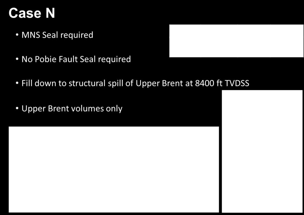
15 Figure 11: Summary of Case M scenario for Tulla prospect. Figure 12: Summary of Case N scenario for Tulla prospect.

16 Figure 13: Summary of Case O scenario for Tulla prospect. Figure 14: Summary of Case P scenario for Tulla prospect.
17 Despite there being a potentially large upside associated with case P, a chance of success of only 6 % (Figure 16), due to it requiring both the Pobie Fault and Mid Ness Shale to act as seals, means that given the current economic climate, the Tulla prospect is uneconomic and cannot be taken any further. Cases M, N, O and P all belong to a technical success scenario in which hydrocarbons are discovered. For the Tulla prospect this has been given a chance of technical success of 73 % (Source: 100 %, Timing/Migration: 90 %, Reservoir Quality: 90 %, Closure 90 % and Containment: 100 %). Taking the 73 % chance of finding hydrocarbons and multiplying this by the probabilities of each of the cases (M-P) occurring (Figure 10), a total chance of success has been calculated and this is given in the table below (Figure 15). Summary of Tulla Volumes: STOIIP (MMstb) Low Mid High Chance of Success Case M % Case N % Case O % Case P % Figure 15: Table showing STOIIP associated with each of the cases as well as the chance of success.

18 Middle Jurassic Torridon Discovery The Torridon prospect (Figure 16) was discovered in 1987 by BP with the 210/25c-6A well. A full Brent sequence with oil shows was encountered, however at the time reservoir quality was not deemed sufficient to develop. Figure 16: Top Brent depth map showing structure across Torridon discovery with location of the discovery well 210/25c-6A on the flank of the structure. The structure is a rotational slump feature against the footwall of the east bounding fault of the Tern- Eider ridge (Figure 17 and Figure 18). The discovery well (210/25c-6A) was drilled on the flank of this structure and the up-dip potential was the main focus of the licence application.

19 Figure 17: Seismic line (shown in yellow in Figure 16) across the Torridon discovery showing current interpretation of BCU (green) and Top Brent (blue) horizons.seismic data courtesy of PGS. Brent Gp Tern Field Depth Ft tvd Torridon BCU Heather & Kimmeridge shales Figure 18: Cross-section across Torridon showing location of discovery well 210/25c-6A.
20 The crest of the structure lies at 11,200 ft tvdss and therefore the key risk with the prospect was the reservoir quality as the Brent group reservoir is seen to undergo significant degradation with depth. The application considered the possibility that early oil migration into the structure may have inhibited illitisation and preserved reservoir quality up-dip of the discovery well, however, recent work from the Pelican and North-West Hutton field areas has seen that degradation of reservoir quality with depth is primarily related to grain size and therefore facies. In both of these fields we see that coarse grained sands undergo significantly less degradation than fine grained sands and only coarse grained sands are able to retain reasonable reservoir quality at depth. Deterministic volumes for the Torridon discovery were calculated using the 210/25c-6A well properties as a base case and the average reservoir parameters from the Pelican Field as a high case. The STOIIP range is MMstb. Using the Pelican Field as an analogue, recovery factors on the whole are about 20 % which would give a reserves range of only MMstb. Given that the average reservoir properties for the Pelican field are better than those observed in the discovery well; it is unlikely that recovery factors of this level would be achievable. The location is too far from existing platforms to be drilled from there and would require development by subsea wells. The prospect is therefore considered uneconomic, at this time, to progress. Upper Jurassic Thunder Prospect (previously Tyrone 2) The Thunder prospect is an Upper Jurassic basin floor fan stratigraphic trap. It potentially consists of five individual lobes, encased within the mature Kimmeridge Clay Formation. The key risk associated with the prospect is the presence of sand in the basin. The presence of sand in the Cladhan Field at the relay ramp to the west of the Thunder basin and some thin sands with oil shows in the wells on the distal margin of the Thunder basin play (210/30-1, 210/30b-3 and 210/25c-6A) show that sands were being deposited during the Upper Jurassic. Although sands were clearly being deposited throughout the Upper Jurassic, what remains uncertain is the quantity and quality of these sands, if any, in the Thunder basin. Mapping of key reflectors within the basin is tricky, with the data suffering from seabed-multiple interference, especially at the Upper Jurassic level. The Base Cretaceous Unconformity and Top Brent events were able to be picked with some confidence across the area, however, the Heather, J66 and J62 flooding surfaces were much less confident picks (Figure 19). Whilst an attempt has been made to map the Thunder lobes within the basin, the confidence associated with these is low due to poor reflectivity within the Upper Jurassic section. An attempt was made to try and model the seismic response expected if sands were present by synthetically inserting 500 ft of sand from the analogous Miller Field into the 210/30b-3 well at the J56 surface in the Thunder basin (Figure 20). The modelling suggested that if similar reservoir sands were to exist within the Thunder basin that they may not be easily observed within the Kimmeridge Clay. This coupled with the conceptual model for the sands suggesting thin, laterally extensive sands that would fall below seismic resolution means it is unlikely that if sands were present in the basin that they would be easily visible, or indeed mappable. Despite evidence of erosion of Upper Jurassic sediment on the East Shetland Platform edge, it is difficult to quantify exact amounts; however, a figure of around 3 million cubic metres has been estimated (Figure 21). This in itself is not sufficient to meet GRV requirements for a Thunder success case and additional sediment would have to have been sourced from further afield or from erosion that cannot be interpreted from the existing data.
; however, whilst some of the work showed promise, none of these")
21 Seismic interpretation has been unable to confirm sufficient sediment source was available for the Thunder prospect. It is therefore considered too high risk to take any further. Attempts were made to try and de-risk this through the use of the available seismic (more detail can be found on this in section 6); however, whilst some of the work showed promise, none of these attempts were successful enough to increase the chance of success of the prospect, which remains at only 5 %. Figure 19: Maps showing interpretation of main Upper Jurassic seismic reflectors as interpreted for the evaluation of the Thunder prospect. Polygons showing the five Thunder lobes are shown on each map.

22 Figure 20: Synthetic modelling to show what seismic response sands may give if they were present in the Thunder basin. Work carried out using 500 ft sand from the Miller Field, inserted into the basinal well 210/30b-3.

23 Figure 21: Seismic line from East Shetland Platform to Thunder basin. Line shows erosion along edge of East Shetland Platform (white triangle). Wells on the platform go from the Tertiary interval directly into the Brent Group, meaning a significant section of Cretaceous and Upper Jurassic sediment is missing from the platform. Seismic data courtesy of PGS.
. Figure 22: Map showing Base Cretaceous structural interpretation across Upper Jurassic Tinsel lead with offset wells.")
24 Upper Jurassic Tinsel Lead (previously Tyrone 1) The Tinsel lead is an Upper Jurassic base of slope wedge (Figure 22), deposited very early in the Upper Jurassic at the base of the hanging wall of the Tern-Eider Ridge fault blocks (Figure 23 and Figure 24). Figure 22: Map showing Base Cretaceous structural interpretation across Upper Jurassic Tinsel lead with offset wells. Seismic section line used in Figure 23 is shown in black.
, lower line shows interpretation carried")
25 Figure 23: Seismic line through Upper Jurassic Tinsel lead. Upper line shows interpretation carried out for initial application on ESB09 PSTM seismic data (courtesy of PGS and TGS), lower line shows interpretation carried out on ESB14 PSDM seismic data (courtesy of PGS). Seismic line location is shown in black on Figure 22.

26 Figure 24: Cross-section through Tinsel lead. Key risks for this lead are the stratigraphic trapping mechanism and the reservoir quality. The up-dip part of the lead relies on sealing against the Tern Horst where it is likely to be offset against the basement. Lateral and top seal are expected to be provided by the Kimmeridge Clay which the sands are deposited within. The other key risk is the nature of the sandstone input into hanging wall of the East Tern fault. The lead can be seismically mapped as a discrete wedge-shaped body immediately down-dip of known erosion of the Upper Brent in the Tern Field. Well based evidence from the Tern Field and adjacent fields suggests that neither the Pobie Fault nor the Tern East fault were active at the time of Brent deposition, meaning that the Brent did not depositionally thin onto the East Tern bounding fault. The Tinsel lead is located immediately down-dip of a complex slump zone at the eastern edge of the Tern Horst. Slumping and erosion at this eastern crest is thought to have contributed the sand into the Tinsel lead feature. This erosion is supported by the three wells closest to proposed slump zone TA25S3, TA25S1 and TA27S1, with the Upper Brent section missing in the latter two wells (Figure 25). TERN FIELD KESTREL FIELD Upper Ness Upper Ness Eroded Figure 25: Tern-Kestrel Brent Group correlation showing erosion of Upper Ness in nearest offset wells TA25S3, TA25S1 and TA27S1.

27 The lead lies in the depth range of 11,000 12,850 ft tvdss and therefore reservoir quality at these depths is uncertain. Diagenesis and compaction have the potential to severely reduce reservoir quality. Previous work suggested that the ability to charge the sandstones relatively early on may inhibit illite in the oil leg and preserve reservoir quality. Recent work carried out using core data from the Pelican and North-West Hutton fields suggests that early oil emplacement has little impact on the ability to preserve reservoir quality at depth, with facies predominantly grain size being the key control. The work carried out showed that coarse grained, clean sands such as fluvial channels underwent significantly less degradation than their finer grained, dirtier more marine facies such as shoreface sands, at the same depths. As the Tinsel lead is comprised of eroded/ slumped re-worked Upper Brent from the Tern Field, the depositional fabric of these re-worked Brent sands could have a significant impact on their ability to retain good reservoir quality at these depths. The Upper Ness, shown in Figure 25 is quite shaley and therefore any eroded Upper Brent may contain a significant proportion of fine grained, shaley material which could promote reservoir degradation at these depths. The risks associated with this lead are considered too high in the current economic climate for the lead to be progressed. Upper Jurassic Tennant Complex Lead The Tennant Complex lead is an Upper Jurassic channelised stratigraphic trap located to the northwest of the Tern-Eider Ridge. Amplitude extraction over the window of BCU and Top Brent horizons highlights the channelised deposits of the Home sands within the licence area (Figure 26). Figure 26: Maps showing location of Tennant channel complex as identified on a maximum amplitude extraction (left) and interpreted BCU structure (depth). The Home sands are a sequence of Upper Jurassic turbiditic sandstones which form in erosive channel features oriented perpendicular to the East Shetland Basin margin. The channels lie within the Kimmeridge Clay, which provides top and base seal to the sands (Figure 27).
28 Figure 27: Geological cross-section showing Tennant channel complex relative to Home Sands seen in 210/19-2. To investigate whether the fluid in the channels could be discriminated using seismic data, a fluid substitution was performed on well 210/19-2 over the Home sands interval. The seismic event at the top of the sand shows that a wet channel has a negative intercept with a positive gradient. An oil filled channel on the other hand would show a positive intercept with a positive gradient; a class III response. Geochemical evaluation of the 210/25b-8Z well suggests that the Kimmeridge Clay within the subbasin is immature and so localised charge from this nearby area is not possible. Any hydrocarbons would have to migrate distances of up to 20 km from a mature kitchen to the south-east of Otter, which is thought to be the source for both the Otter and Eider West Fields. Migration into the Tennant channels is therefore considered to be extremely high risk and for this reason the lead has not been taken any further.
29 6.0 Further Technical Work Undertaken Reservoir Quality Analysis Reservoir quality and the associated degradation with depth for the Middle Jurassic Torridon prospect were assessed using petrophysical data from the nearby wells as well as utilising in-house knowledge from a range of analogous Brent fields, in particular Pelican, Darwin and NW Hutton. Looking at the core from these fields in detail it was identified that facies (grain size, detrital clay content) had a significant control on the ability of a sand to preserve good reservoir quality at depth. Finer grained marine type sandstone facies (e.g. shoreface sands) show a higher potential for illite precipitation and tend to be located in stratigraphically deeper sections (in particular the Rannoch and Broom). Medium to coarse grained fluvial type sandstone facies (fluvial and tidal channels (Ness)) preserve the best reservoir quality due to their grain size and cleaner primary depositional character. The depositional fabric of the reservoir is therefore a key component in assessing the reservoir quality of deeper targets. Geochemistry Hydrocarbon fingerprinting studies have been performed within TAQA to enhance the understanding of the regional distribution of mature Kimmeridge Clay and the migration routes of the hydrocarbons to the producing fields. This study was particularly relevant to the Tennant lead where migration into the Upper Jurassic sands was considered a key risk. The geochemical study showed that oils from the Otter and Eider West Fields have significant similarities in composition, indicative of a shared mature kitchen to the south-east of Otter. If any hydrocarbons were able to migrate into the Tennant lead then it is most likely to have been sourced from this kitchen which is over 20 km away. Rock Physics and Lithology Classification Rock physics analysis was performed for the key wells in the area in order to compute elastic properties and generate relevant cross-plots for use in calibrating seismic inversion products. The resultant MuRho volume was found to be useful in identifying the sand packages within the Upper Jurassic when used in conjunction with the attributes (Figure 28) and reflection data. For many of the Upper Jurassic prospects and leads, in particular Thunder, the presence of reservoir sand presents the biggest risk. In order to try and de-risk this somewhat, a significant effort was made to try and use the available data to predict lithologies (sand or shale) within the Upper Jurassic interval. The two basinal wells (210/30b-3 and 210/30-1) were used for shale calibration and a Cladhan well (with a depth correction applied) for the sands. The 2D results derived from crossplotting P-Impedance vs. S-Impedance were encouraging; with test lines over the Thunder prospect showing that discrimination between sand and shale may be possible (Figure 30). Although these results were promising, they were ultimately unsuccessful in confirming sand presence in the basin and reducing the risk sufficiently.


30 TAQA Bratani Ltd. Figure 28: Seismic line showing cosine of phase attribute, used for helping to pick on lap, down lap and truncation events. Figure 29: Seismic line showing MuRho attribute across Thunder lobes. Attribute was found to be useful in identifying potential sand packages when used with reflectivity and other attribute volumes.
 could retain an oil column")
31 Figure 30: Line showing attempted lithological discrimination of Thunder prospect, highlighting potential sand presence in the Thunder-1 and Thunder-2 lobes. Fault Seal Study An independent fault seal evaluation was carried out by Tim Needham for the Tulla prospect which suggested that the main bounding fault (the Pobie Fault) could retain an oil column down to 8510 ft based on Shale Gouge Ratio (SGR) and Shale Smear Factor (SSF) methods. Whilst this study suggested that fault seal may work at the Tulla prospect location, analogue data from TAQAs Brent Fields gave limited evidence that fault seal would be present at the Tulla location and the risks associated with this were considered too high. Risking and Volumetrics Mapping of the licence area was carried out using the ESB14 Pre-Stack Depth Migrated Seismic Survey which covered the licence area. The updated mapping did not have a significant impact on the leads and prospects previously identified, due to limited fault movement at Brent level and issues with seabed multiples throughout the Upper Jurassic interval. Unfortunately, the subsequent risking and current economic climate deemed that the risks associated with the leads and prospects were too high to allow the prospects to be considered any further.
32 7.0 Resource and Risk Summary On the basis of the assessment of prospectivity on the Licence, recoverable reserves potential is considered to be low risk but small and uneconomic in the current climate or larger but extremely high risk. Partners agree to determine the P1995 licence one month from receipt of the licence determination document. Name Maturity Strat. Level Resource and Risk Summary STOIIP Key Risks/ Uncertainties Tulla Prospect Middle Jurassic MMstb Reservoir quality of the Brent Group Ability for fault seal along Pobie fault MNS seal Torridon Discovery Middle Jurassic MMstb Reservoir quality Depth conversion fault imaging Thunder Prospect Upper Jurassic MMstb Reservoir presence Reservoir quality Stratigraphic pinch-out Tinsel Lead Upper Jurassic MMstb Reservoir quality Reservoir Presence Trapping mechanism Tennant Lead Upper Jurassic MMstb Reservoir quality Trapping mechanism Migration 8.0 Conclusions Both Upper and Middle Jurassic sands are recognised as plays in this area, due to the Cladhan field to the west and the many surrounding Brent Group Fields. The prospects and leads identified within the licence area have been assessed and it is deemed that the risks associated with them are too high and reserves potential is considered to be small and uneconomic. The operator (TAQA) and its partner (Cairn) agree to determine the licence P1995 at the end of the Initial Term (31 st December 2016). 9.0 Clearance The operator, TAQA (50 %) and its partner Cairn (50 %) confirm that the OGA is free to publish information documented in this report and that all 3rd party ownership rights (on any contained data and/or interpretations) have been considered and appropriately cleared for publication purposes.
Serica Energy (UK) Limited. P.1840 Relinquishment Report. Blocks 210/19a & 210/20a. UK Northern North Sea
 Limited. P.1840 Relinquishment Report. Blocks 210/19a & 210/20a. UK Northern North Sea") Serica Energy (UK) Limited P.1840 Relinquishment Report Blocks 210/19a & 210/20a UK Northern North Sea January 2013 1 Header Licence: P.1840 Round: Licence Type: 26th Round Traditional "Drill-or-Drop"
Serica Energy (UK) Limited P.1840 Relinquishment Report Blocks 210/19a & 210/20a UK Northern North Sea January 2013 1 Header Licence: P.1840 Round: Licence Type: 26th Round Traditional "Drill-or-Drop"
Relinquishment Report
 Relinquishment Report Licence P1403 Block 13/22d Chevron North Sea Limited Korean National Oil Company Chevron North Sea Limited December 2009 1 SYNOPSIS... 3 2 INTRODUCTION. 3 2.1 Licence Terms.. 3 2.2
Relinquishment Report. for. Licences: P.1596 (Blocks 205/3, 205/4a) P.1836 (Block 205/2b) P.1837 (Block 205/5b)
 P.1836 (Block 205/2b) P.1837 (Block 205/5b)") Relinquishment Report for Licences: P.1596 (Blocks 205/3, 205/4a) P.1836 (Block 205/2b) P.1837 (Block 205/5b) November 2013 1 of 9 CONTENT 1. Header 2. Synopsis 3. Exploration Activities 4. Prospectivity
Relinquishment Report for Licences: P.1596 (Blocks 205/3, 205/4a) P.1836 (Block 205/2b) P.1837 (Block 205/5b) November 2013 1 of 9 CONTENT 1. Header 2. Synopsis 3. Exploration Activities 4. Prospectivity
Relinquishment Report. Licence P2016 Block 205/4c
 Relinquishment Report Licence P2016 Block 205/4c September 2016 JX Nippon Exploration and Production (U.K.) Limited Idemitsu Petroleum UK Ltd. Table of Contents 1. Licence Information... 1 2. Licence Synopsis...
UK P2060, Block 29/06b Licence Relinquishment
 ENDEAVOUR ENERGY UK LIMITED UK P2060, Block 29/06b Licence Relinquishment ISSUE RECORD SUMMARY Dec 2015 Final Graham Tegerdine Rev Date Description Document Owner Review Required By Table of Contents 1
Licence P Relinquishment Report
 Licence P.1762 Relinquishment Report February 2014 Relinquishment Report P.1762 1 Licence Information 1 2 Licence Synopsis 2 3 Work Programme Summary 3 4 Database 4 5 Prospectivity Update 5 6 Additional
RELINQUISHMENT REPORT. UK Traditional Licence P Blocks 12/16b & 12/17b. First Oil Expro Limited (Operator, 46.67%)
") RELINQUISHMENT REPORT UK Traditional Licence P.1887 Blocks 12/16b & 12/17b First Oil Expro Limited (Operator, 46.67%) Nautical Petroleum Limited (26.67%) North Sea Energy (UK NO2) Limited (26.67%) February
RELINQUISHMENT REPORT UK Traditional Licence P.1887 Blocks 12/16b & 12/17b First Oil Expro Limited (Operator, 46.67%) Nautical Petroleum Limited (26.67%) North Sea Energy (UK NO2) Limited (26.67%) February
Licence Relinquishment Report. P.1400 Block 12/30. First Oil Expro Ltd
 Licence Relinquishment Report P.1400 Block 12/30 First Oil Expro Ltd December 2007 Seaward Production Licence P.1400, Block 12/30 Block 12/30 was awarded 100% to Reach Exploration North Sea Ltd as a promote
1. LICENCE INFORMATION. P209 Block 9/29a ALL. U.K. Block 9/29a (Part Block) Operator/Partners TAQA Bratani Ltd 81%, RWE DEA UK 19%
 Operator/Partners TAQA Bratani Ltd 81%, RWE DEA UK 19%") 1. LICENCE INFORMATION Licence P209 Block 9/29a ALL Licence Round 4th round Blocks U.K. Block 9/29a (Part Block) Licence Type Traditional (Production) Well Operator TAQA Bratani Ltd Operator/Partners TAQA
1. LICENCE INFORMATION Licence P209 Block 9/29a ALL Licence Round 4th round Blocks U.K. Block 9/29a (Part Block) Licence Type Traditional (Production) Well Operator TAQA Bratani Ltd Operator/Partners TAQA
Relinquishment Report Licence P1834
 Valiant Causeway Limited, March 2013 1. Header Licence Number: P1834 Licence Round: 26th Round Licence Type: Traditional Block Number: 204/21, 22b, 23b & 26a Partners: Valiant 100% (Operator) 2. Synopsis
RELINQUISHMENT REPORT FOR LICENCE P.1663, BLOCK 29/4b and 29/5e
 RELINQUISHMENT REPORT FOR LICENCE P.1663, BLOCK 29/4b and 29/5e Licence: P.1663 Blocks: 29/4b & 29/5e 25th Round Traditional Licence Operator: Ithaca Energy UK(Ltd) 100% Work Programme Summary The agreed
Relinquishment Report for Licence P.1265, Block 12/28
 Relinquishment Report for Licence P.1265, Block 12/28 1. Licence Information Licence Number: P.1265 Licence Round: 23 rd Round Awarded 22 December 2005 Licence Type: Traditional Block Number(s): 12/28
Licence P1368: Relinquishment Report (end of 2 nd term) Hurricane Exploration PLC
 Hurricane Exploration PLC") Licence P1368: Relinquishment Report (end of 2 nd term) Hurricane Exploration PLC March 2012 1. Header Licence Number: P1368 Licence Round: 23 rd Licence Type: Frontier Block Numbers: 202/4, 202/5, 204/30,
Licence P1368: Relinquishment Report (end of 2 nd term) Hurricane Exploration PLC March 2012 1. Header Licence Number: P1368 Licence Round: 23 rd Licence Type: Frontier Block Numbers: 202/4, 202/5, 204/30,
Plumbing the Depths of the Pelican Field
 Plumbing the Depths of the Pelican Field Thurza Frenz Pelican Talk Objectives To discuss the development of the northern area of the Pelican Field, in particular: The relationship between reservoir quality,
Relinquishment report P.1190 & P Blocks: 204/13, 204/14b
 Relinquishment report P.1190 & P.1262 Blocks: 204/13, 204/14b CONTENTS 1: LICENCE DETAILS... 2 2: LICENCE SYNOPSIS... 2 3: WORK PROGRAMME SUMMARY... 3 4. DATABASE... 5 5: PROSPECTIVITY UPDATE... 6 6. RESERVE
Licence P.185, Blocks 30/11b and 30/12b Relinquishment Report February 2015
 1. General Licence: P.185 Round: 4 th (1972) Licence Type: Traditional Blocks: 30/11b (part) and 30/12b (part) Equity: Talisman Sinopec Energy UK Limited 60%, Centrica North Sea Oil Limited 40% Work Programme:
1 Licence Information 4. 2 Licence Synopsis 4. 3 Work Programme Summary 5. 4 Database 6. 5 Prospectivity Update 8
 Table of Contents 1 Licence Information 4 2 Licence Synopsis 4 3 Work Programme Summary 5 4 Database 6 5 Prospectivity Update 8 6 Further technical work undertaken 16 7 Clearance 16 P1610 Page 2 of 16
P1794 Relinquishment Document Blocks 22/2d, 22/3c & 22/4c
 P1794 Relinquishment Document Blocks 22/2d, 22/3c & 22/4c 1. Licence Information Licence Number: P1794 Licence Round: 26 th Round- Awarded January 2011 Licence Type: Traditional; (Drill or Drop within
P1645 Fig 1: Licence P1645 Introduction
 Licence Number: P.1645 commenced 12 th November 2008 Licence Round: 25 th Licence Type: Traditional Block Number: 9/8b Operator: EnQuest (60%) Partners: Norwegian Energy Company (Noreco) UK Ltd 40% Work
RWE Dea UK SNS Limited (50%), Faroe Petroleum (UK) Limited
, Faroe Petroleum (UK) Limited") 1. Licence information Licence Number P1975 Licence Round 27 th (2012) Licence Type Traditional Blocks 3/28c & 9/3e Licensees Work Programme 2. Synopsis RWE Dea UK SNS Limited (50%), Faroe Petroleum (UK)
1. Licence information Licence Number P1975 Licence Round 27 th (2012) Licence Type Traditional Blocks 3/28c & 9/3e Licensees Work Programme 2. Synopsis RWE Dea UK SNS Limited (50%), Faroe Petroleum (UK)
Figure 1: PEDL 155 Location Map
 Licence Details UK Onshore Licence PEDL 155 October 2014 Licence Number: PEDL 155 Licence Round: UK 12 th Onshore Licensing Round Effective Date: 1 October 2004 Licence Type: Petroleum Exploration and
LICENCE RELINQUISHMENT REPORT UKCS LICENCE P.1084 SUB-BLOCK 13/27a DEE DANA PETROLEUM (E&P) LIMITED UK EXPLORATION
 LIMITED UK EXPLORATION") LICENCE RELINQUISHMENT REPORT UKCS LICENCE P.1084 SUB-BLOCK 13/27a DEE DANA PETROLEUM (E&P) LIMITED UK EXPLORATION December 2011 TABLE OF CONTENTS LIST OF TABLES & FIGURES... 3 LICENCE INFORMATION... 4
LICENCE RELINQUISHMENT REPORT UKCS LICENCE P.1084 SUB-BLOCK 13/27a DEE DANA PETROLEUM (E&P) LIMITED UK EXPLORATION December 2011 TABLE OF CONTENTS LIST OF TABLES & FIGURES... 3 LICENCE INFORMATION... 4
P1488 DECC Relinquishment Report OMV (U.K.) Ltd.
 Ltd.") 1. Synopsis: P1488 DECC Relinquishment Report OMV (U.K.) Ltd. UK offshore Licence P1488 was awarded to OMV, Dana Petroleum and Rocksource in the 24 th Licence Round on the 24 th of January 2007 as a frontier
1. Synopsis: P1488 DECC Relinquishment Report OMV (U.K.) Ltd. UK offshore Licence P1488 was awarded to OMV, Dana Petroleum and Rocksource in the 24 th Licence Round on the 24 th of January 2007 as a frontier
Relinquishment Report for Licence Number P1435, Block 30/25a March 2009
 Relinquishment Report for Licence Number P1435, Block 30/25a March 2009 Endeavour Energy UK Ltd Relinquishment Report for Licence Number P1435 Block 30/25a 1 Table of Contents 1.0 Header...3 2.0 Synopsis...3
Relinquishment Report. Licence P1616. Block 21/12b
 Relinquishment Report Licence P1616 Block 21/12b EOG Resources United Kingdom Limited March 2014 List of Contents 1. Licence information 2. Licence Synopsis 3. Work Programme Summary 4. Database 5. Further
RWE Dea UK SNS Limited (50%, operator) Dana Petroleum (E&P) Limited (50%)
 Dana Petroleum (E&P) Limited (50%)") 1. Licence Information Licence Number P1726 Licence Round 25 th (2008) Licence Type Traditional Blocks 43/17a & 43/18a Licensees Work Programme RWE Dea UK SNS Limited (50%, operator) Dana Petroleum (E&P)
1. Licence Information Licence Number P1726 Licence Round 25 th (2008) Licence Type Traditional Blocks 43/17a & 43/18a Licensees Work Programme RWE Dea UK SNS Limited (50%, operator) Dana Petroleum (E&P)
UKCS License P th Round Traditional Carrizo Oil & Gas, Inc. (operator) 100%
 100%") Block 22/8a Relinquishment Report UKCS License P.1797 26 th Round Traditional Carrizo Oil & Gas, Inc. (operator) 100% March 2015 Estimates, statistics, opinions and forecasts contained in this document
Block 22/8a Relinquishment Report UKCS License P.1797 26 th Round Traditional Carrizo Oil & Gas, Inc. (operator) 100% March 2015 Estimates, statistics, opinions and forecasts contained in this document
Relinquishment Report for Licence P1980
 Relinquishment Report for Licence P1980 Estimates, statistics, opinions and forecasts contained in this document are based on TOTAL s own information and knowledge. They are provided in good faith, but,
P.1619 License Relinquishment Report
 P.1619 License Relinquishment Report Effective Date: 14 th October 2015 1. Licence Information License Number: P.1619 License Round: 25 th License Type: Traditional Block Number(s): 21/27b Operator: MOL
Appraising a late-middle-aged Brent Group field
 Appraising a late-middle-aged Brent Group field Reservoir learnings after nearly 20 years of Pelican field production Jill Marriott The Pelican Field The Pelican oil field is nearly 20 years old It is
Relinquishment Report
 Relinquishment Report Licence P.089 Block 22/15a 2 nd Round Traditional Licence Award (Operator): 100.0% Disclaimer No representation or warranty, express or implied, is or will be made in relation to
Ardent Oil Limited. Relinquishment report. Promote Licence P1953. Blocks 22/24h. March 2015
 Ardent Oil Limited Relinquishment report Promote Licence P1953 Blocks 22/24h March 2015 Licence P1953 Block 22/24h Relinq report Page 1 of 9 Ardent Oil Limited Relinquishment report for Block 22/24h 1.0
Relinquishment Report. for. Licence P.272 Block 20/7a
 Relinquishment Report for Licence P.272 Block 20/7a February 2007 1 of 16 CONTENT 1 - Introduction 2 - Exploration Activities 2.1 - Purchase 130km2 of Aker 1999 survey 2.2 Reprocessing of 3D Aker data
TAQA Bratani Limited & INEOS Clipper South C Limited
 [1] TAQA Bratani Limited and INEOS Clipper South C Limited UKCS Licence Block 211/27e [2] Table of Contents 1. Licence Information... 3 2. Licence Synopsis... 3 3. Work Programme Summary... 6 4. Database...
P1125 Relinquishment Report for Blocks 30/23a, 30/27a and 30/28a
 P1125 Relinquishment Report for Blocks 30/23a, 30/27a and 30/28a Header Licence Number P1125 Licence Round 21st Round Licence Type Traditional Production Licence Block Numbers 30/23a, 30/27a and 30/28a
June 2014 RELINQUISHMENT REPORT LICENCE P1454
 June 2014 RELINQUISHMENT REPORT LICENCE P1454 Relinquishment Report Licence P1454, Block 208/11 and 214/15 1. Licence Information Licence number P1454 (Figure 1) Licencing Round 24th First Term Awarded
Relinquishment Report for Licence Number P1471 Block 16/8f March 2009
 Relinquishment Report for Licence Number P1471 Block 16/8f March 2009 Endeavour Energy UK Ltd Relinquishment Report for Licence Number P1471 Block 16/8f 1 Table of Contents 1.0 Header...3 2.0 Synopsis...3
Relinquishment Report. for. Licence P.1046 Block 20/2c
 Relinquishment Report for Licence P.1046 Block 20/2c Submitted to DTI in September 2006 September 2006 1 of 14 CONTENT 1 - Introduction 2 - Exploration Activities 2.1 - Purchase 100km2 of Aker 1999 survey
Relinquishment Report Licence P1597
 Relinquishment Report Licence P1597 Valiant Causeway Limited, February 2013 1. Header Licence Number: P1597 Licence Round: 25 th Round Licence Type: Traditional Block Numbers: 206/5b and 207/1b Partners:
UK Onshore Licence PEDL 153 Relinquishment Report September 2010
 UK Onshore Licence PEDL 153 September 2010 Licence Details Licence Number : PEDL 153 Licence Round : UK 12 th Onshore Licensing Round Effective Date: 1 October 2004 Licence Type : Petroleum Exploration
Relinquishment Report. for. Licence P1605, Block 220/27
 Relinquishment Report for Licence P1605, Block 220/27 November 2013 Licence P.1605 Relinquishment Report August 2012 1 of 11 CONTENT 1 Introduction 2 - Exploration Summary 2.1 Exploration Activity 2.2
North Sea Business Unit. Fay Licence Relinquishment
 North Sea Business Unit Fay Licence Relinquishment P.1260, Block 22/2b (Premier Oil 100% Operator) Section Contents 1 Header 2 Synopsis 3 Exploration Activities 4 Prospect Analysis 5 Reserves Summary 6
RELINQUISHMENT REPORT
 RELINQUISHMENT REPORT Licences P1743 & P1744 Blocks 47/10c & 48/6d BP Exploration Operating Company Ltd. Prepared by: Rishi Dorai (BP Exploration) Issued: 02 March 2015 CONTENTS 1 Licence Information...
Relinquishment Report for Exploration License P.1749
 Part Block 49/24c Oranje-Nassau Energie B.V. UN Studio, 7 th floor Parnassusweg 815 1082 LZ, Amsterdam The Netherlands Date: Report No.: Issue No.: 12 September 2016 20160602-RL1 Document Control Prepared:
All permissions to publish have been obtained (see Section 9)
") 1. Licence Information Licence Number: P1741 Licence Round: 26 th Round Licence Type: Traditional Block Numbers: 42/13b, 42/17 & 42/18 All permissions to publish have been obtained (see Section 9) 2. Licence
1. Licence Information Licence Number: P1741 Licence Round: 26 th Round Licence Type: Traditional Block Numbers: 42/13b, 42/17 & 42/18 All permissions to publish have been obtained (see Section 9) 2. Licence
Licence P1667, block 43/22b, Relinquishment Report - Centrica Energy Upstream
 Licence P1667, block 43/22b, Relinquishment Report - Centrica Energy Upstream 1 General 1 2 Synopsis 2 3 Exploration Activities 2 4 Prospectivity Analysis 2 5 Reserves Summary 5 6 Clearance 5 List of figures
Jaeren High, Central North Sea
 Relinquishment Report Jaeren High, Central North Sea Licence: P.2004 Blocks: 22/10b, 22/15c, 23/6 and 23/11b Date: November 2014 Disclaimer No liability whatsoever is accepted and no representation, warranty
Exploration Well Failures from the Moray Firth & Central North Sea (UK) 21 st Century Exploration Road Map Project Christian Mathieu
 21 st Century Exploration Road Map Project Christian Mathieu") Exploration Well Failures from the Moray Firth & Central North Sea (UK) 21 st Century Exploration Road Map Project Christian Mathieu 1. Project Objectives, Time-Line and Status 2. A few statistics 3. Reasons
Exploration Well Failures from the Moray Firth & Central North Sea (UK) 21 st Century Exploration Road Map Project Christian Mathieu 1. Project Objectives, Time-Line and Status 2. A few statistics 3. Reasons
Relinquishment Report for Licence Number P1356, Block 48/8c March 2008
 Relinquishment Report for Licence Number P1356, Block 48/8c March 2008 Table of Contents 1.0 Header...3 2.0 Synopsis...3 3.0 Exploration Activities...4 4.0 Prospectivity Analysis...11 5.0 Conclusions...12
P057 Relinquishment Report Apache North Sea Ltd PLEASE WITHOLD PUBLISHING UNTIL AFTER THE 27 TH ROUND LICENSES HAVE BEEN AWARDED
 PLEASE WITHOLD PUBLISHING UNTIL AFTER THE 27 TH ROUND LICENSES HAVE BEEN AWARDED 1 1. License Information License Number: P057 License Round: 2nd Round License Type: Traditional Block Number: 21/9 (see
Relinquishment Report
 Relinquishment Report Licence P421 Block 21/20b Centrica North Sea Oil Ltd Shell UK Ltd May 2013 Disclaimer No liability whatsoever is accepted and no representation, warranty or undertaking, express or
P2061 Relinquishment Report
 Document last updated 23-07-2015 12:28 CEST 1 Licence Information 1 2 Licence Synopsis 2 3 Work Program 4 4 Database 8 4.1 Seismic 8 4.2 Gravity and Magnetics 10 5 Prospectivity Update 12 6 Resource and
1 Licence Number and Block Details
 Licence Number and Block Details 1 Licence Number and Block Details Table 1.1: Licence details. Licence Number: P1343 Licence Round: 23rd Round Licence Type: Traditional Block(s): 43/30b, 48/05a & 49/01b
Relinquishment Report. Block 48/11c
 Relinquishment Report Petroleum Production Licence No. P.1008 Block 48/11c EOG Resources United Kingdom Limited List of Contents 1. Licence information 2. Synopsis 3. Exploration Activities 4. Prospectivity
Relinquishment Report. for. Licence P1972 Blocks 3/9e,3/10a and 3/15b. September 2015
 Relinquishment Report for Licence P1972 Blocks 3/9e,3/10a and 3/15b September 2015 1 CONTENT Licence Summary & Status Technical Evaluation Introduction 27th Round Application Well data base Seismic Work
P1906 Relinquishment Report
 Relinquishment Report Date of Document: Approval list Date Centrica North Sea Gas Ltd Carla Riddell 16/12/15 Serica Energy (UK) Ltd Clara Altobell 11/12/15 Atlantic Petroleum North Sea Ltd Alyson Harding
MUHAMMAD S TAMANNAI, DOUGLAS WINSTONE, IAN DEIGHTON & PETER CONN, TGS Nopec Geological Products and Services, London, United Kingdom
 Geological and Geophysical Evaluation of Offshore Morondava Frontier Basin based on Satellite Gravity, Well and regional 2D Seismic Data Interpretation MUHAMMAD S TAMANNAI, DOUGLAS WINSTONE, IAN DEIGHTON
Bulletin of Earth Sciences of Thailand. Evaluation of the Petroleum Systems in the Lanta-Similan Area, Northern Pattani Basin, Gulf of Thailand
 Evaluation of the Petroleum Systems in the Lanta-Similan Area, Northern Pattani Basin, Gulf of Thailand Sirajum Munira Petroleum Geoscience Program, Department of Geology, Faculty of Science, Chulalongkorn
APPENDIX C GEOLOGICAL CHANCE OF SUCCESS RYDER SCOTT COMPANY PETROLEUM CONSULTANTS
 APPENDIX C GEOLOGICAL CHANCE OF SUCCESS Page 2 The Geological Chance of Success is intended to evaluate the probability that a functioning petroleum system is in place for each prospective reservoir. The
28 th ROUND OF UK OFFSHORE LICENSING
 28 th ROUND OF UK OFFSHORE LICENSING RELINQUISHMENT REPORT LICENSE P2266 Block 47/6 Swift Exploration Ltd Stelinmatvic Industries Ltd April 2017 1 Location Licence P2266 Block 47/6 in the UK Southern Gas
P1846 Relinquishment Report
 Document last updated 23-07-2015 12:32 CEST 1 Licence Information 1 2 Licence Synopsis 2 3 Work Program 4 3.1 Seismic Reprocessing 4 4 Database 7 4.1 Seismic 7 4.2 Gravity and Magnetics 9 5 Prospectivity
Carrizo Oil & Gas, Inc. (op) 40% E.ON Ruhrgas UK Exploration and Production Ltd. 30% Norwegian Energy Company UK Ltd. 30%
 40% E.ON Ruhrgas UK Exploration and Production Ltd. 30% Norwegian Energy Company UK Ltd. 30%") Relinquishment Report UKCS License P.1660 25 th Round Traditional Block 22/9b February 2011 Carrizo Oil & Gas, Inc. (op) 40% E.ON Ruhrgas UK Exploration and Production Ltd. 30% Norwegian Energy Company
Relinquishment Report UKCS License P.1660 25 th Round Traditional Block 22/9b February 2011 Carrizo Oil & Gas, Inc. (op) 40% E.ON Ruhrgas UK Exploration and Production Ltd. 30% Norwegian Energy Company
21/29c Relinquishment Document
 /9c Relinquishment Document ) icence information icence : P.5 lock(s) : /9c South West ocation : Western Platform, CNS Operator : EnCore Petroleum (5.6%) Co-venturers : Petro-Canada (5.00%) Nexen (8.98%)
Trapping Mechanisms along North Similan and Lanta Trends, Pattani Basin, Gulf of Thailand
 Trapping Mechanisms along North Similan and Lanta Trends, Pattani Basin, Gulf of Thailand Piyaporn Aukkanit Petroleum Geoscience Program, Department of Geology, Faculty of Science, Chulalongkorn University,
CHRYSAOR CNS LIMITED. Relinquishment Report for Licence P 1977 UKCS Blocks 8/27, 8/28, 14/5, 14/10, 15/1, 15/2, 15/3, 15/6, 15/7 and 15/8
 CHRYSAOR CNS LIMITED Relinquishment Report for Licence P 1977 UKCS Blocks 8/27, 8/28, 14/5, 14/10, 15/1, 15/2, 15/3, 15/6, 15/7 and 15/8 1. Licence Information During 2012 Chrysaor CNS Limited applied
RELINQUISHMENT REPORT. License P1546 Block April 2009
 RELINQUISHMENT REPORT License P1546 Block 110-01 14 April 2009 Sherritt International Oil and Gas Limited 2000, 425-1 st street S.W., Calgary, Alberta Canada T2P 3L8 Telephone (403) 260-2900 Fax (403)
Serica Energy (UK) Limited. P.1568 Relinquishment Report. Block 110/2d. UK East Irish Sea
 Limited. P.1568 Relinquishment Report. Block 110/2d. UK East Irish Sea") Serica Energy (UK) Limited P.1568 Relinquishment Report Block 110/2d UK East Irish Sea August 2012 1 Header Licence: P.1568 Round: 25th UK Licensing Round Block: 110/2d Licence Type: Traditional Equity:
Serica Energy (UK) Limited P.1568 Relinquishment Report Block 110/2d UK East Irish Sea August 2012 1 Header Licence: P.1568 Round: 25th UK Licensing Round Block: 110/2d Licence Type: Traditional Equity:
Licence P900 Block 49/8b Relinquishment Report
 Relinquishment Report Licence P900 Block 49/8b August 2009 Licence P900 Block 49/8b Relinquishment Report 1. Header -Licence Summary Licence Number: P900 Licence Round: 15 th Seaward Licensing Round Licence
Relinquishment Report P1967 Block 2/4b. December 2014
 Relinquishment Report P967 Block 2/4b December 204 Block 2/4b Relinquishment Report General. Introduction.2 Commitments 2 2 Summary Exploration Activities 4. Wells Drilled 4.2 Seismic Database 5 4 Prospectivity
Downloaded 09/09/15 to Redistribution subject to SEG license or copyright; see Terms of Use at
 Reservoir properties estimation from marine broadband seismic without a-priori well information: A powerful de-risking workflow Cyrille Reiser*, Matt Whaley and Tim Bird, PGS Reservoir Limited Summary
Adding Value with Broadband Seismic and Inversion in the Central North Sea Seagull Area
 H2-2-1 Adding Value with Broadband Seismic and Inversion in the Central North Sea Seagull Area Marnix Vermaas, Andy Lind Apache North Sea, Aberdeen, UK Introduction The merits of modern broadband seismic
Relinquishment Report. Licence P.2058
 Shell U.K. Limited Relinquishment Report for Licence P.2058 (Block 29/7b) Important Notice This Relinquishment Report does not purport to be all-inclusive or to contain all of the information that an interested
Relinquishment Report
 Southern North Sea Block 44/29c - Licence P1593 Relinquishment Report December 2012 GDF SUEZ E&P UK Ltd BY PEOPLE FOR PEOPLE Document last updated 18-12-2012 09:59 GMT Licence P1593 Relinquishment Report
SAND DISTRIBUTION AND RESERVOIR CHARACTERISTICS NORTH JAMJUREE FIELD, PATTANI BASIN, GULF OF THAILAND
 SAND DISTRIBUTION AND RESERVOIR CHARACTERISTICS NORTH JAMJUREE FIELD, PATTANI BASIN, GULF OF THAILAND Benjawan KIinkaew Petroleum Geoscience Program, Department of Geology, Faculty of Science, Chulalongkorn
Hydrocarbon Potential of the Marginal Fields in Niger Delta Oza Field, a case study*
 Hydrocarbon Potential of the Marginal Fields in Niger Delta Oza Field, a case study* J.N. Sahu 1, C.H.V. Satya Sai 1, V. Chintamani 1 and C. Vishnu Vardhan 1 Search and Discovery Article #20182 (2012)*
High Resolution Field-based Studies of Hydrodynamics Examples from the North Sea
 High Resolution Field-based Studies of Hydrodynamics Examples from the North Sea Stephen O Connor 1, Richard Swarbrick 2 and Sam Green 1 1 Ikon GeoPressure, Durham, UK 2 Swarbrick Geopressure Consultancy,
1 Licence Number and Block Details
 Licence Number and Block Details 1 Licence Number and Block Details Table 1.1: Licence details. Licence Number: P1185 Licence Round: 22nd Round Licence Type: Traditional Block(s): 44/29c Table 1.2: Consortium
Relinquishment Report. for. License P. 799
 Shell U.K. Limited Relinquishment Report for License P. 799 Relinquishment of Block 214/21a Important Notice This Relinquishment Report is presented by Shell U.K. Limited ( Shell ), on behalf of the P799
The Kingfisher Field, Uganda - A Bird in the Hand! S R Curd, R Downie, P C Logan, P Holley Heritage Oil plc *
 A Bird in the Hand! EXTENDED ABSTRACT The Kingfisher Field, Uganda - A Bird in the Hand! Heritage Oil plc * The Kingfisher Field lies on Uganda s western border beneath Lake Albert, situated in the western
The importance of stratigraphic plays in the undiscovered resources of the UKCS
 The importance of stratigraphic plays in the undiscovered resources of the UKCS Sue Stoker 1, Joy Gray 2, Peter Haile 2, Ian Andrews 1 & Don Cameron 1 1 British Geological Survey 2 Department of Trade
How fast can a falcon fly?
 How fast can a falcon fly? DEVEX 9 th May 2012 Peter Brand Overview Overview Timeline Appraisal Development Performance Potential Summary / Conclusions Overview - Location Falcon Tern Kestrel Shetland
QUANTITATIVE INTERPRETATION
 QUANTITATIVE INTERPRETATION THE AIM OF QUANTITATIVE INTERPRETATION (QI) IS, THROUGH THE USE OF AMPLITUDE ANALYSIS, TO PREDICT LITHOLOGY AND FLUID CONTENT AWAY FROM THE WELL BORE This process should make
Petroleum Potential of the Application Area L12-4
 Petroleum Potential of the Application Area L12-4 The Application Area (L12-4) is underlain by the western Officer Basin, beneath the Gunbarrel Basin. The general basin architecture is outlined in Figure
Interpretation and Reservoir Properties Estimation Using Dual-Sensor Streamer Seismic Without the Use of Well
 Interpretation and Reservoir Properties Estimation Using Dual-Sensor Streamer Seismic Without the Use of Well C. Reiser (Petroleum Geo-Services), T. Bird* (Petroleum Geo-Services) & M. Whaley (Petroleum
For personal use only
 ASX ANNOUNCEMENT 11 September 2018 Billion Barrel Oil Potential Assessed in Pancontinental s PEL 87 Offshore Namibia Giant* scale oil potential in multiple Large Leads in PEL 87 Vast Cretaceous Superfan
5 ORIGINAL HYDROCARBONS IN PLACE
 5 ORIGINAL HYDROCARBONS IN PLACE The deterministic estimation of oil in place for the White Rose Field was completed using 3-D geological modelling in the RMS software package. This procedure involves
Quantitative Interpretation
 Quantitative Interpretation The aim of quantitative interpretation (QI) is, through the use of amplitude analysis, to predict lithology and fluid content away from the well bore. This process should make
HORDA SURVEY HERALDS NEW STRATEGY
 HORDA SURVEY HERALDS NEW STRATEGY CGG sets sights on multi-client market leadership in Norway BY IDAR HORSTAD, ERLING FRANTZEN AND JO FIRTH, CGG 12 seismic profile Figure 1: Reprocessing of the Cornerstone
Implications of the Rabat Deep 1 exploration well on the prospectivity of the surrounding area
 Transformational Growth Through Exploration Implications of the exploration well on the prospectivity of the surrounding area Morocco Brazil Namibia South Atlantic 100 Ma Reconstruction Growth through
Deep-Water Reservoir Potential in Frontier Basins Offshore Namibia Using Broadband 3D Seismic
 Deep-Water Reservoir Potential in Frontier Basins Offshore Namibia Using Broadband 3D Seismic E. Polyaeva* (Petroleum Geo-Services), I. Thomas (Chariot Oil and Gas), C. Reiser (Petroleum Geo-Services),
Using high-density OBC seismic data to optimize the Andrew satellites development
 Using high-density OBC seismic data to optimize the Andrew satellites development Leendert Padmos, 1* Daniel Davies, 1 Merv Davies 1 and John McGarrity 1 Abstract The processed data from conventional towed-streamer
Bulletin of Earth Sciences of Thailand. Controls on Reservoir Geometry and Distribution, Tantawan Field, Gulf of Thailand.
 Controls on Reservoir Geometry and Distribution, Tantawan Field, Gulf of Thailand Atchara Praidee Petroleum Geoscience Program, Department of Geology, Faculty of Science, Chulalongkorn University, Bangkok
Relinquishment Report
 Relinquishment Report P1790 Blocks 21/27a & 28/2a March 2013 P1790 Block 21/27a Relinquishment Report 1 General 1 2 Synopsis 3 3 Exploration Activities 4 3.1 Wells Drilled 4 3.2 Seismic Database 6 4 Prospectivity
Key Elements of the Petroleum Systems of the Rockall and Slyne-Erris Basins
 Key Elements of the Petroleum Systems of the Rockall and Slyne-Erris Basins Bandon Corrib Dooish Atlantic Ireland Conference, Dublin, 1 st - 2 nd November 2016 Rockall and Slyne-Erris Basins Only 11 exploration
Key findings of the CPR:
 New World Oil and Gas Plc / Index: AIM / Epic: NEW / Sector: Oil & Gas 16 August 2011 New World Oil and Gas Plc ( New World or the Company ) Prospectivity of the Danica Jutland Project, Denmark, highlighted
Fairfield Cedrus Limited. Bayerngas Europe Limited. UKCS Licence P1746. Blocks 48/11c and 48/12b. Relinquishment Report. January 2015 [1] January 2015
![Fairfield Cedrus Limited. Bayerngas Europe Limited. UKCS Licence P1746. Blocks 48/11c and 48/12b. Relinquishment Report. January 2015 [1] January 2015](/thumbs/88/117762153.jpg "Fairfield Cedrus Limited. Bayerngas Europe Limited. UKCS Licence P1746. Blocks 48/11c and 48/12b. Relinquishment Report. January 2015 [1] January 2015") [1] Bayerngas Europe Limited UKCS Licence P1746 Blocks 48/11c and 48/12b [2] Table of Contents 1. Licence Information... 3 1.1 Summary... 3 1.1.1 Area Affected... 4 1.2. History... 5 2.0 Field and Reservoir
[1] Bayerngas Europe Limited UKCS Licence P1746 Blocks 48/11c and 48/12b [2] Table of Contents 1. Licence Information... 3 1.1 Summary... 3 1.1.1 Area Affected... 4 1.2. History... 5 2.0 Field and Reservoir
Downloaded 09/29/16 to Redistribution subject to SEG license or copyright; see Terms of Use at
 Richard Wright*, James Carter, Ian Atkinson, Erin Gillis, Deric Cameron, and Leona Stead, Nalcor Energy Tom Neugebauer, TGS Jerry Witney, PGS Daniel Hughes and Michael Hall, Airbus Defence and Space Summary
P105 Block 49/29b Tristan NW Relinquishment Report
 P105 Block 49/29b Tristan NW Relinquishment Report Date: January 2011 Document No: BEL-TNW-REP-004- Rev1 Page 1 of 7 Document Approval, Distribution & Revision Prepared by: Signature Alasdair MacMillan.
BARRYROE OIL IN PLACE RESOURCE UPDATE
 July 25 th 2012 Embargo 7am BARRYROE OIL IN PLACE RESOURCE UPDATE UPDATED OIL IN PLACE ESTIMATES RESERVOIR INTERVAL P50 (MMBO) P10 (MMBO) MIDDLE WEALDEN 287 706 BASAL WEALDEN 756 906 TOTAL 1,043 1,612
Tim Carr - West Virginia University
 GEOGRAPHIC EXTENT OF PETROLEUM SYSTEM A Trap Trap Trap A STRATIGRAPHIC EXTENT OF PETROLEUM SYSTEM Petroleum accumulation Top of oil window Bottom of oil window Overburden Seal Reservoir Source Underburden