Practice Packet Topic 4: Dynamic Crust
|
|
|
- Erika Hamilton
- 5 years ago
- Views:
Transcription


1 PRACTICE PACKET: TOPIC 4 Dynamic Crust Practice Packet Topic 4: Dynamic Crust ITALY Aug magnitude Vocabulary: Lesson 1: Lesson 2: Lesson 3: Lesson 4: Lesson 5: Name: Lesson 6:
2 PRACTICE PACKET: TOPIC 4 Dynamic Crust VOCABULARY For each word, provide a short but specific definition from YOUR OWN BRAIN! No boring textbook definitions. Write something to help you remember the word. Explain the word as if you were explaining it to an elementary school student. Give an example if you can. Don t use the words given in your definition! Lithosphere: Asthenosphere: Inner Core: Outer Core: Continental Crust: Oceanic Crust: Plate Tectonic Theory: Pangea: Reversal of Magnetic Polarity: Convergent: Subduction: Divergent: Mid-Ocean Ridge: Transform: Original Horizontality: Fault: Fold: Earthquake: Epicenter: Focus: Seismogram:

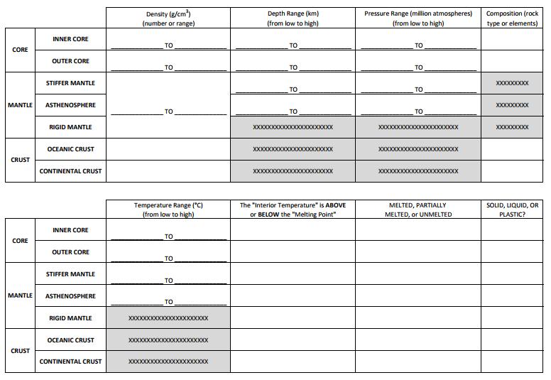
3 Primary (P) Waves: Secondary (S) Waves: Tsunami: Origin: Ring of Fire: Intrusion: Extrusion: Lesson 1 Earth s Interior Objective: I can explain how scientists know about the layers of the Earth I can name & explain the two types of crust I can describe the importance of the asthenosphere I can compare & contrast the inner and outer core I can use the Inferred Properties of Earth s Interior Chart The Earth s interior is made up of four layers (see diagram below)... Crust: Solid, outer layer of the Earth Mantle: Part solid, part melted layer beneath the crust Outer Core: Melted, metallic layer beneath the mantle made of iron & nickel Inner Core: Solid, metallic layer beneath the outer core made of iron & nickel As Earthquake waves pass through these layers they bend (refract) and sometimes are stalled or stopped. Scientists analyze earthquake and meteorite impact data to study the behavior of waves in order to infer what each layer is composed of. The outer-most part of the mantle is completely solid and is called the rigid mantle. The rigid mantle and the crust together make up the lithosphere. This solid lithosphere floats upon the melted part of the mantle beneath. This melted part of the mantle is called the asthenosphere. It is not completely melted into a liquid, it is thick and gooey, like chewed up bubble gum. We refer to this gooey asthenosphere as plastic. 3
4 The diagram seen to the right can be found on page 10 of your reference tables. Pay attention to the following details: As you travel deeper down, from the crust to the inner core, the materials get increasingly dense. As you travel deeper down, from the crust to the inner core, the pressure increases. As you travel deeper down, from the crust to the inner core, the temperature increases. The MOHO is the boundary between the crust and the mantle. There are two types of crust: o Continental crust which is made of a very thick layer of the rock granite and is less dense (2.7 g/cm3) o Oceanic crust which is made of a very thin layer of the rock basalt and is more dense (3.0 g/cm3) Wherever the interior temperature is higher than the melting point, the material is a liquid (see the outer core. Questions: 1. What happens to earthquake waves as they pass through the different layers of Earth s interior? 2. What two things do scientists use to infer the composition of Earth s interior? 3. Why does Earth s interior have a layered structure? 4. What is the outermost layer of Earth? 5. What does the lithosphere include? & 6. What is another name for the asthenosphere? 7. What happens to temperature, density, & pressure as you travel deeper into Earth s interior? 8. How do you know if the layer is a liquid or a solid based on the chart? 4
5 9. Fill in the chart below describing the continental & oceanic crust. Thick/ Thin Rock Name Density Mafic/Felsic Continental Crust Oceanic Crust 1. Look at the information above the chart. Highlight each of the following labels that indicate the location on Earth s surface: Pacific Ocean, North America, and Atlantic 2. Find and highlight the Cascades and complete the sentence below: The Cascades are located at the boundary of the and 3. What is located next to the Cascades but in the Pacific Ocean? 4. Highlight the word Trench. 5. What is located on Earth s crust, in the Atlantic Ocean? 6. Highlight Mid-Atlantic Ridge 7. Highlight the following Labels on the chart: Density, Lithosphere, Pressure, Temperature and Depth 8. Referring to the top of the chart, what two layers does the lithosphere include? and 9. Using a red color pencil lightly shade in the Asthenosphere section in the chart. Start at the top right side (under density) and follow the dotted lines all the way down to the bottom of the graph. Under the density section, color ONLY the top section next to the Asthenosphere section. 10. Using a brown color pencil lightly shade in the Stiffer Mantle section in the chart. Start at the top right side and follow the dotted lines all the way down to the bottom of the graph. Under the density section, color ONLY the section next to the Stiffer Mantle section. 11. Using an orange color pencil lightly shade in the Outer Core section in the chart. Start at the top right side and follow the dotted lines all the way down to the bottom of the graph. Under the density section, color ONLY section next to the Outer Core section. 12. Using a purple color pencil lightly shade in the Inner Core section in the chart. Start at the top right side and follow the dotted lines all the way down to the bottom of the graph. Under the density section, color ONLY the section next to the Inner Core section. 13. Refer to the temperature section of the chart for the following questions. a. What layer of Earth s interior is partially melted? b. Is the melting point [ higher or lower ] than the interior temperature in the outer core? c. This means that the Outer Core must be a [ solid or liquid ]. 14. Fill in the tables below with information found on the Inferred Properties of Earth s Interior Chart. 5
6 6

7 Regents Questions: 1. Compared to the oceanic crust, the continental crust is usually a. thicker, with a less dense granitic composition b. thicker, with a more dense basaltic composition c. thinner, with a less dense granitic composition d. thinner, with a more dense basaltic composition Base your answers to questions 2 through 4 on the data table, the graph, and on your knowledge of Earth science. The data table shows the velocity of seismic S-waves at various depths below Earth s surface. The graph shows the velocity of seismic P-waves at various depths below Earth s surface. Letter A is a point on the graph. 2. On the graph, plot the S-wave velocity at each depth given on the data table. Connect the plots with a line. 3. What property of Earth s interior causes the S-waves to stop at 2900 km, but allows the P-waves to continue? 4. State the pressure and temperature of Earth s interior at the depth indicated by point A on the graph. 5. Which two Earth layers are separated by the Moho boundary? a. rigid mantle and plastic mantle c. stiffer mantle and asthenosphere b. outer core and stiffer mantle d. crust and rigid mantle 6. According to the ESRT, at 4,500 km below the surface of the Earth, the pressure is estimated to be a. 1.4 million of atmospheres c. 2.8 million of atmospheres b. 2.0 million of atmospheres d. 3.1 million of atmospheres 7. The data table shows the origin depths of all large-magnitude earthquakes over a 20-year period. According to these data, most of these earthquakes occurred within Earth s a. Lithosphere c. Asthenosphere b. Stiffer Mantle d. Outer Core 7
8 8. The composition of some meteorites supports the inference that the Earth s core is composed of a. Magnesium and potassium c. iron and nickel b. Silicon and oxygen d. aluminum and calcium ASSESS YOURSELF ON THIS LESSON: /8 If you missed more than 2, do the Additional Practice. If not, go on to the next hw video!!! 9. A part of which zone of the Earth s interior inferred to have a density of 10.0g/cm 3? a. Outer core b. inner core c. crust d. mantle 10. According to the ESRT, in which group are the zones of the Earth s interior correctly arranged in order of increasing average density a. Crust, mantle, inner core, outer core c. crust, mantle, outer core, inner core b. Inner core, outer core, mantle, crust d. outer core, inner core, mantle, crust 11. According to the ESRT, the temperature of rock located 1,000 km below the Earth s surface is about a. 200ºC b. 2,100 ºC c. 2,800 ºC d. 3,200 ºC 12. Compared to the oceanic crust, the continental crust is a. less dense and more basaltic c. more dense and more granitic b. less dense and more felsic d. more dense and more mafic 13. Earth s internal heat is the primary source of energy that a. warms the lower troposphere c. moves the lithospheric plates b. melts glacial ice at lower altitudes d. pollutes deep groundwater with radioactivity ASSESS YOURSELF ON THIS ADDITIONAL PRACTICE: /5 If you missed more than 2 you should see me for extra help and/or re-watch the lesson video assignment and/or watch the podcast link on the ESRT page on the website. Lesson 2 Plate Tectonics Objective: I can describe what is believed to make the plates move? I can name proof that the Earth s plates have moved over time I can describe age & heat patterns located at the Mid Ocean Ridges 1. What is the plate tectonic theory? 2. List at least 3 pieces of evidence for plate tectonics. 3. What process causes the plates to move? 4. What layer in the Earth is this occurring? 8

9 Seafloor Spreading Divergent boundaries occur along spreading centers where plates are moving apart. New crust is created by magma pushing up from the mantle. Picture two giant conveyor belts facing each other slowly moving in opposite directions as they transport newly formed oceanic crust away from the ridge crest. As the plates separate, water fills the low areas. Crust continues to separate allowing more magma to emerge making small underwater hills at the point of separation. Eventually a mid-ocean ridge will form. The youngest rocks are located at the center of the ridge because they are still being formed. The oldest are located the farthest from the ridge. 5. Which directions do plates move at a divergent boundary? 6. What is created as magma moves to the surface? 7. What happens as the plates separate? 8. What will eventually form at a divergent boundary? 9. Where are the youngest rocks found in the ocean? 10. Where are the oldest rocks found? 11. Fill in the chart below. Relative Age Relative Heat At mid-ocean ridge Away from mid-ocean ridge Normal & Reverse Magnetic Polarity When geologists studied the polarity of ancient rocks, they were stunned to discover that in many iron minerals were aligned toward the south magnetic pole, not the north. Scientists have concluded that the Earth s magnetic field has reversed itself again and again throughout the ages. When the iron minerals point toward the north magnetic pole, as it does today, the rocks are record it have normal polarity. When the iron minerals point toward the south magnetic pole, opposite of its current behavior, the rocks have reversed polarity. All rocks of the same age have the same polarity. In the 1970's, scientists sailed back and forth across the world s oceans, measuring the magnetic polarity. These surveys revealed a series of invisible magnetic stripes of normal and reversed polarity in the sea floor, like that shown in the figure below. 12. What inference about the magnetic polarity can best be made by looking at the picture? 13. The Mid-Atlantic Ridge is slowly being created at 3cm/year. How long would it take to create a kilometer of new crust? (1km = cm) 9


10 Hot Spots Hot spots are places where magma is coming up through Earth s crust that are not necessarily located at a plate boundary. As the plates move over the hot spot volcanic islands can form. The block diagram below shows the bedrock age as measured by radioactive dating and the present location of part of the Hawaiian Island chain. These volcanic islands may have formed as the Pacific Plate moved over a mantle hot spot. Use the diagram to the right to answer the following questions. 14. Which island is the youngest? 15. Which island is the oldest? 16. Which compass direction was the Pacific crust moving toward? 17. A new island is already forming off the coast of Hawaii named Loihi. By looking at the diagram to the right, what compass direction (from Hawaii) is Loihi forming? Regents Questions: 1. The cross section below shows the ocean floor between 2 continents. Points A through D represent location on the ocean floor where samples of oceanic crust were collected. The youngest rock sample most likely was collected from location a. A b. B c. C d. D 2. Which statement best supports the theory of continental drift? a. Basaltic rock is found to be progressively younger at increasing distances from a midocean ridge. b. Marine fossils are often found in deep-well drill cores. c. The present continents appear to fit together as pieces of a larger landmass d. Areas of shallow-water seas tend to accumulate sediment, which gradually sinks. 3. The cross section shows the direction of movement of an oceanic plate over a mantle hot spot, resulting in the formation of a chain of volcanoes labeled A, B, C, and D. The geologic age of volcano C is shown. What are the most likely geologic ages of volcanoes B and D? a. B is 5 million years old and D is 12 million years old. b. B is 2 million years old and D is 6 million years old. c. B is 9 million years old and D is 9 million years old. d. B is 10 million years old and D is 4 million years old. 10


11 The map below shows the continents of Africa & South America, the ocean between them, & the ocean ridge & transform faults. 4. The hottest crustal temperature measurements would most likely be found at which location? a. A b. B c. C d. D 5. Which graph best shows the relative age of the ocean-floor bedrock from location B to C? 6. Which of the cross-sectional diagrams below best represents a model for the movement of rock material below the crust along the Mid-Atlantic Ridge? 7. Which is the best evidence supporting the concept of ocean floor spreading? a. Earthquakes occur at greater depths beneath continents than beneath oceans. b. Sandstones and limestones can be found both in North America and Europe. c. Volcanoes appear at random within the oceanic crust. d. Igneous rocks along the mid-oceanic ridges are younger than those farther from the ridges. Base your answers to questions 7 and 8 on the cross section below and on your knowledge of Earth science. The cross section represents the distance and age of ocean-floor bedrock found on both sides of the Mid-Atlantic Ridge. 8. According to the cross section, every 1 million years, the ocean floor bedrock moves approximately a. 20 km toward the Mid-Atlantic Ridge c. 40 km toward the Mid-Atlantic Ridge b. 20 km away from the Mid-Atlantic Ridge d. 40 km away from the Mid-Atlantic Ridge 9. Which map best represents the pattern of magnetic polarity in the minerals of ocean-floor bedrock on each side of the Mid-Atlantic Ridge? 11
12 10. The cross section represents a pattern of magnetic field reversals preserved in the igneous bedrock of the oceanic crust east of the Mid- Atlantic ridge. Which cross section best represents the magnetic field pattern west of the Mid-Atlantic ridge? 11. Two samples of ocean floor basaltic bedrock are found at equal distances from, and on opposite sides of, a mid-ocean ridge. The best evidence that both samples were formed at the ridge during the same time period would be that both samples also a. have the same density b. contain different crystal sizes c. are located at different depths below sea level d. have the same magnetic field orientation ASSESS YOURSELF ON THIS LESSON: /11 If you missed more than 3, do the Additional Practice. If not, go on to the next hw video!!! 1. The theory of continental drift does not explain the a. matching of rock features on continents thousands of kilometers apart b. melting of glacial ice at the close of the Pleistocene Epic c. apparent fitting together of many continental boundaries d. fossils of tropical plants in Antarctica 2. Igneous rocks on the ocean floor that have an alternating pattern of magnetic orientation provide evidence that a. mountains are rising c. the seafloor is spreading b. the Earth was struck by meteorites d. ocean tides are cyclic 3. Which statement best supports the theory that all the continents were once a single landmass? a. Rocks of the ocean ridges are older than those of the adjacent sea floor b. Rock and fossil correlation can be made where the continents appear to fit together. c. Marine fossils can be found at high elevations above sea level on all continents. d. Great thickness of shallow water sediments are found at interior locations on some continents. 12
13 4. For the last 200 million years, continents on opposite sides of the Atlantic ocean have generally a. been drifting apart c. been drifting closer together b. remained the same distance apart ASSESS YOURSELF ON THIS ADDITIONAL PRACTICE: /4 If you missed more than 2 you should see me for extra help and/or re-watch the lesson video assignment. Lesson 3 Plate Boundaries Objective: I can name & explain the movements associated with Convergent plate boundaries I can name & explain the movements associated with Divergent plate boundaries I can name & explain the movements associated with Transform plate boundaries 1. Using a yellow highlighter, highlight the NAMES of each of the following... - hot spots, ocean ridges, and trenches 2. In the boxes below, draw the symbols for each of the following boundaries: 3. Draw the symbol for the Mid-Ocean Ridge. 4. What do the arrows on the map indicate? 5. In the table below, state the direction of movement of the plates 6. Find the San Andres Fault. What type of boundary is this? 13
14 7. Fill in the names of the Hot Spots at each of the following locations. 8. Name the two plates located on either side of each of the following trenches. 9. Look at the arrows along any of the trenches, on the two adjoining plates. Are the plates moving toward each other or away from each other? 10. What kind of boundary is located at a trench? 11. Name the two plates located on either side of each of the following ridges. 12. Look at the arrows along any of the ridges, on the two adjoining plates. Are the plates moving toward each other or away from each other? 13. What kind of boundary is located at a ridge? 14


15 Regents Questions: 1. Oceanic crust is sliding beneath the Aleutian Islands in the North Pacific Ocean, forming the Aleutian Trench at a a. convergent plate boundary between the Pacific Plate and the North American Plate b. convergent plate boundary between the Pacific Plate and the Juan de Fuca Plate c. divergent plate boundary between the Pacific Plate and the North American Plate d. divergent plate boundary between the Pacific Plate and the Juan de Fuca Plate 2. The map shows California and a section of the San Andreas Fault. What is the primary geologic process occurring along the San Andreas Fault? a. transform movement c. subduction b. spreading movement d. convergence 3. Which mantle hot spot is located directly below a mid-ocean ridge plate boundary? a. Yellowstone b. Iceland c. Canary Islands d. Hawaii 4. Which landmass is moving northward with Australia as part of the same tectonic plate? a. India b. Antarctica c. North America d. South America Base your answers to questions 5 and 6 on the map below and on your knowledge of Earth science. The map shows the coast of the northwestern United States. The Explorer and Gorda ridges and plates are parts of the Juan de Fuca tectonic system. 5. The arrow on which map best shows the direction of movement of the Juan de Fuca Plate in relation to the Juan de Fuca Ridge? 6. The Explorer Ridge is the boundary between the Explorer Plate and the a. North American Plate c. Pacific Plate b. Juan de Fuca Plate d. Gorda Plate 15


16 7. The diagram to the right shows a tectonic plate boundary. Which mantle hot spot is at a plate boundary like the one shown in this diagram? a. Hawaii Hot Spot c. Yellowstone Hot Spot b. Galapagos Hot Spot d. Canary Hot Spot 8. Which diagram correctly shows how mantle convection currents are most likely moving beneath colliding lithospheric plates? 9. Based on the theory of plate tectonics, it is inferred that over the past 250 million years North America has moved toward the a. northwest b. southeast c. southwest d. northeast 10. According to tectonic plate maps, New York State is presently located a. at a convergent plate boundary c. above a mantle hot spot b. above a mid-ocean ridge d. near the center of a large plate 11. The diagram to the right shows the interaction of two tectonic plates. The type of plate boundary represented in the diagram most likely exists between the a. Antarctic Plate and the African Plate b. Antarctic Plate and the Indian-Australian Plate c. South American Plate and the Nazca Plate d. South American Plate and the African Plate 12. The movement of tectonic plates is inferred by many scientists to be driven by a. tidal motions in the hydrosphere c. density differences in the troposphere b. convection currents in the asthenosphere d. solidification in the lithosphere 16


17 Base your answers to questions below, which is an enlargement of a portion of the Tectonic Plates map form the ESRT. Points A & B are locations on different boundaries of the Arabian Plate. 13. Identify the type of tectonic plate boundary located at A. 14. On the map shown a valley is located south of point B and a mountain range north of point B. State the tectonic process that is creating these two land features. 15. The block diagram below represents Earth s surface and interior along the East African Rift. Draw two arrows, one through point X & one through point Y, to indicate the relative motion of each of these sections of the continental crust. ASSESS YOURSELF ON THIS LESSON: /15 If you missed more than 3, do the Additional Practice. If not, go on to the next hw video!!! 1. The Aleutian Islands extend westward from southern Alaska to form the northern boundary of the Pacific Ocean. These volcanic islands were formed by the nearby a. subduction of a continental plate c. divergence of a continental plate b. subduction of an oceanic plate d. divergence of an oceanic plate 2. At which plate boundary is one lithospheric plate sliding under another? a. Pacific Plate and Indian-Australian Plate c. Nazca Plate and Pacific Plate b. Indian-Australian Plate and Antarctic Plate d. Nazca Plate and Antarctic Plate 17
18 3. Convection currents in the plastic mantle are believed to cause divergence of lithospheric plates at the a. Peru-Chile Trench c. Mariana Trench b. Canary Islands Hot Spot d. Iceland Hot Spot 4. The Himalayan Mountains are located along a portion of the southern boundary of the Eurasian Plate. At the top of Mt. Everest (29,028 feet) in the Himalayan Mountains, climbers have found fossilized marine shells in the surface bedrock. From this observation, which statement is the best inference about the origin of the Himalayan Mountains? a. The Himalayan Mountains were formed by volcanic activity. b. Sea level has been lowered more than 29,000 feet since the shells were fossilized. c. The bedrock containing the fossil shells is part of an uplifted seafloor. d. The Himalayan Mountains formed at a divergent plate boundary. 5. Which two tectonic plates are separated by a mid-ocean ridge? a. Indian-Australian and Eurasian c. Indian-Australian and Pacific b. North American and South American d. North American and Eurasian 6. Which of the following locations is the site of a convergent plate boundary? a. Mid-Atlantic ridge c. Pacific/North American plate boundary b. Atlantic-Indian ridge d. Aleutian Trench ASSESS YOURSELF ON THIS ADDITIONAL PRACTICE: /6 If you missed more than 2 you should see me for extra help and/or re-watch the lesson video assignment and/or watch the podcast link on the ESRT page on the website. Lesson 4 Earthquakes Objective: I can identify the different types of crustal features I can describe what an earthquake is & where earthquakes start I can explain how to measure an earthquake I can tell the differences between P & S waves I can name the scales used to measure earthquake damage I understand earthquake safety I can describe a tsunami Directions: Using your knowledge of earthquakes & your ESRT answer the following questions. Earthquakes An earthquake is the shaking of Earth s crust. The most common cause is the interaction between lithospheric plates (movement of plates). Convection currents cause the plates to move. These plates are very rigid and although they are not attached to each other, it is almost as if they are interlocked. It takes an incredible amount of force to get them to actually move relative to each other. Once enough pressure has built up and the plates move, there is an enormous amount of energy released. This is why most major earthquakes occur at or near plate boundaries. 1. What is an earthquake? 18

19 2. What is the most common cause of an earthquake? 3. What causes plates to move? 4. Where do most major earthquakes occur? 5. What is the name of the giant waves generated by earthquakes underwater? 6. Where do Earthquakes start? a. : Beneath the Earth s surface b. : Point on the Earth s surface directly above where it started 7. Fill in the chart below stating the differences between P & S waves. Name Speed What it travels through P-Waves S-Waves Scientists have found a pattern of where major earthquakes and volcanoes are located. The map shows where some of Earth s earthquakes and volcanoes are. See if you can find a correlation. 8. Using the reference tables as a guide, label the following plates using red. Eurasian Plate (2 places) Antarctic Plate (2 places) African Plate Pacific Plate South American Plate Philippine Plate Indian Australia Plate North American Plate Nazca Plate 19

20 9. Where are most earthquakes and volcanoes located? 10. Identify the type of plate boundary responsible for the presence of the volcano at location A. 11. The location where the actual movement of plates takes place is called the focus. The depth of the focus changes depending on the plates involved. Using a red color pencil, draw an arrow on the diagram to the right that shows the ocean plate is being subducted. 12. What happens to the depth of the focus as you move to the right of the subduction zone? 13. What type of boundary is illustrated in the diagram? 14. Ocean plates are [thicker / thinner] and [ more dense / less dense ] than the continental plates. 15. What is the density of the oceanic plate? (don t forget units) 16. What is the density of the continental plate? (don t forget units) 17. Which plate is subducted continental or oceanic? Why? 18. What land features formed as a result of the oceanic and continental plate collision? Regents Questions: 1. Which coastal area is most likely to experience a severe earthquake? a. east coast of North America c. east coast of Australia b. west coast of Africa d. west coast of South America 2. According to tectonic plate maps, New York State is presently located a. at a convergent plate boundary c. above a mantle hot spot b. above a mid-ocean ridge d. near the center of a large plate 20


21 3. The map shows changes in the position of the tsunami wave front produced by the 1964 Alaskan earthquake. The numbers indicate the time, in hours, for the wave front to reach the positions indicated by the isolines. If the wave front reached the Hawaiian Islands at 10:30 p.m., at approximately what time did the earthquake occur? a. 1:30 p.m. c. 5:30 p.m. b. 3:30 a.m d. 4:30 a.m. Base your answers to the questions below on the map and a modified Mercalli intensity scale below. The map shows modified Mercalli intensity scale damage zones resulting from a large earthquake that occurred in The earthquake s epicenter was near Anchorage, Alaska. The cities Kodiak and Anchorage are shown on the map. The Mercalli scale describes earthquake damage at Earth s surface. 4. Describe one type of damage that occurred in Anchorage but not in Kodiak. 5. Write the names of the two converging tectonic plates that caused this earthquake. 6. Explain why S waves from this earthquake were not directly received on the opposite side of Earth. 7. This earthquake produced a large ocean floor displacement. Identify one dangerous geologic event affecting Pacific Ocean shorelines as a result of this ocean floor displacement. 8. Determine the latitude and longitude of this epicenter. Include the units and compass directions in your answer. 21

22 9. The diagram represents how the earthquake s magnitude is determined by drawing a line connecting the difference in arrival times of the P-wave and the S-wave, and the S-wave amplitude. What is the magnitude of a recorded earthquake if the difference in arrival times of the first P-wave and S-wave is 2 seconds and the S-wave amplitude is 20 millimeters? a. 3.8 c. 2.0 b. 3.0 d. 4.8 Base your answers to questions 10 through 12 on the maps and table below and on your knowledge of Earth science. The maps show earthquake intensities (IV to IX), according to the table of the Modified Mercalli Intensity Scale, for the 1906 and 1989 earthquakes at several locations in California. The asterisk( * ) on each map is the location of each epicenter. The dashed line represents the location of a major fault. 10. Explain why Santa Rosa experienced a lower Modified Mercalli intensity shaking than Salinas experienced during the 1989 earthquake. 11. Name the major fault along which both of these earthquakes occurred and identify the type of plate tectonic boundary that is located along this fault. 22
23 12. Based on the Modified Mercalli Intensity Scale, identify the perceived shaking and the observed damage that occurred in the San Francisco area during the 1906 earthquake. ASSESS YOURSELF ON THIS LESSON: /12 Lesson 5 Reading P & S wave Chart Objective: I can read & interpret the P & S wave chart in the ESRT PART A: Determining travel time Example: How long does it take a P-wave to travel 2,000 km? a) Place a straight piece of scrap paper vertically just to the right of the 2,000 km line, starting at the bottom. b) Where the P-wave curve crosses the scrap paper, follow the horizontal line to the left. This will give you the travel time. c) Answer the question. How long does it take a P-wave to travel 2,000 km? min sec Practice Questions 1. How long does it take an S-wave to travel 7,000 km? min sec 2. How long does it take a P-wave to travel 3,900 km? min sec 3. How long does it take a S-wave to travel 1,600 km? min sec 4. How long does it take a P-wave to travel 8,200 km? min sec 5. How long does it take an S-wave to travel 2,100 km? min sec 23
24 PART B: Determining distance Example: How far can an S-wave travel in 11 minutes 00 seconds? A) Place the scrap paper just above the 11 minute line, starting at the left. B) Where the S-wave crosses the scrap paper, go straight down. This will give you distance. C) Answer the question: How far can an S-wave travel in 11 minutes 00 seconds? km Practice Questions 1. How far can a P-wave travel in 12 minutes 00 seconds? km 2. How far can an S-wave travel in 9 minutes 40 seconds? km 3. How far can a P-wave travel in 4 minutes 20 seconds? km 4. How far can a S-wave travel in 6 minutes 20 seconds? km 5. How far can a P-wave travel in 8 minutes 30 seconds? km Regents Questions: 1. How long would it take for the first S-wave to arrive at a seismic station 4,000 kilometers away from the epicenter of an earthquake? a. 5 min 40 sec b. 7 min 0 sec c.12 min 40 sec d. 13 min 20 sec 2. Approximately how long does an earthquake P-wave take to travel the first 6500 kilometers after the earthquake occurs? a. 6.5 min b. 8.0 min c.10.0 min d.18.5 min 3. A P-wave takes 10 minutes and 20 seconds to travel from the epicenter of an earthquake to a seismic station. Approximately how far is the station from the epicenter? a km b km c km d km 4. A S-wave takes 12 minutes and 40 seconds to travel from the epicenter of an earthquake to a seismic station. Approximately how far is the station from the epicenter? a km b km c km d km 5. A P-wave takes 8 minutes and 20 seconds to travel from the epicenter of an earthquake to a seismic station. Approximately how long will an S-wave take to travel from the epicenter of the same earthquake to this seismic station? a. 6 min 40 sec b. 9 min 40 sec c. 15 min 00 sec d. 19 min 00 sec 6. The epicenter of an earthquake is located 2,800 kilometers from a seismic station. Approximately how long did the S-wave take to travel from the epicenter to the station? a. 11 min 15 sec b. 9 min 35 sec c. 5 min 20 sec d. 4 min 20 sec 24
25 PART C: Determining arrival time difference of P-wave and S-wave Example: What is the difference in arrival time if the distance is 8,000 km? A) Find the distance for 8,000 km on the bottom of the chart. B) Place a scrap paper vertically (up and down) on the line for that distance C) Mark where the P-wave touches the scrap paper and label it P D) Mark where the S-wave touches the scrap paper and label it S E) Move the paper to the left, bottom of the chart. Place the mark for the P-wave at zero, go up to the S-wave mark and read the time. F) Answer the question: What is the difference in arrival time if the distance is 8,000 km? min sec Practice Questions 1. What is the difference in arrival time if the distance is 5,200 km? min sec 2. What is the difference in arrival time if the distance is 9,600 km? min sec 3. What is the difference in arrival time if the distance is 6,400 km? min sec 4. What is the difference in arrival time is the distance is 3,200 km? min sec 5. What is the difference in arrival time if the distance is 4,400 km? min sec Regents Questions: 7. A seismic station is recording the seismic waves produced by an earthquake that occurred 4200 kilometers away. Approximately how long after the arrival of the first P-wave will the first S- wave arrive? a. 1 min 05 sec b. 5 min 50 sec c. 7 min 20 sec d. 13 min 10 sec 8. The first S-wave arrived at a seismograph station 11 minutes after an earthquake occurred. How long after the arrival of the first P-wave did this first S-wave arrive? a. 3 min 15 s b. 4 min 55 s c. 6 min 05 s d. 9 min 00 s PART D: Determining arrival times Example: A seismic station 4000 kilometers from the epicenter of an earthquake records the arrival time of the first P-wave at 10:00:00. At what time did the first S-wave arrive at this station? A) Find 4000 km at the bottom of the chart. B) What is the time difference between the P and S waves at this distance? C) What time did the P wave arrive? D) How much later did the S wave arrive? (time difference) E) Add the time difference to the arrival time of the P wave then answer the question: F) Answer the question: At what time did the first S-wave arrive at this station? 25
26 Regents Questions: 9. An earthquake s first P-wave arrives at a seismic station at 12:00:00. This P-wave has traveled 6000 kilometers from the epicenter. At what time will the first S-wave from the same earthquake arrive at the seismic station? a. 11:52:20 b. 12:07:40 c. 12:09:20 d. 12:17: An earthquake s first S-wave arrives at a seismic station at 3:36:55. This S-wave has traveled 3200 kilometers from the epicenter. At what time did the first P-wave from the same earthquake arrive at the seismic station? a. 3:41:30 b. 3:15:20 c. 3:32:15 d. 3:52:40 E: Determining the distance to an epicenter Example: How far away is the distance to an epicenter if the difference in arrival time is 3 minutes and 20 seconds? A) Place a scrap paper on the left side of the chart B) Mark the zero and label it P C) Place a mark at 3 minutes and 20 seconds and label it S D) Keep the paper vertical and move it to the right until the S mark is touching the S-wave line and the P wave mark is touching the P-wave line. E) Follow the scrap paper down and read the distance at the bottom of the graph. This is the distance to the epicenter. F) Answer the question: How far away is the distance to an epicenter if the difference in arrival time is 3 minutes and 20 seconds? km Practice Questions How far away is the distance to an epicenter if the difference in arrival time is 1) 5 minutes 20 seconds km 2) 6 minutes 00 seconds km 3) 1 minute 40 seconds km 4) 8 minutes 40 seconds km Regents Questions: 11. An earthquake s P-wave arrived at a seismograph station at 02 hours 40 minutes 00 seconds. The earthquake s S-wave arrived at the same station 2 minutes later. What is the approximate distance from the seismograph station to the epicenter of the earthquake? a. 1,100 km b. 2,400 km c. 3,100 km d. 4,000 km 26
27 PART F: Determining the distance to an epicenter when arrival times are given. Example: A seismic recording station recorded an earthquake P-wave at 1:00:20. The S-wave arrived shortly after at 1:04:40. How far is the epicenter from this seismic recording station? A) Subtract the P-wave arrival time from the S-wave arrival time S wave arrival time P wave arrival time _- Difference B) Using the procedure on page 5 determine the distance to the epicenter km Practice Questions 1) A seismic recording station recorded an earthquake s P-wave at 1:15:30. The S-wave arrived shortly after at 1:19:50. How far away is the epicenter from this seismic recording station? S wave arrival time P wave arrival time _- Difference Distance to the epicenter km 2) A seismic recording station recorded an earthquake s P-wave at 3:25:00. The S-wave arrived shortly after at 3:33:40. How far away is the epicenter from this seismic recording station? S wave arrival time P wave arrival time _- Difference Distance to the epicenter km 3) A seismic recording station recorded an earthquake s P-wave at 12:08:30. The S-wave arrived shortly after at 12:15:30. How far away is the epicenter from this seismic recording station? S wave arrival time P wave arrival time _- Difference Distance to the epicenter km 27
28 PART G: Determining epicenter locations. A minimum of seismic stations are needed to locate an earthquake epicenter. - One seismic station gives you only, and NOT direction - Two stations may give you possible locations where the two circles intersect - When stations are used, the epicenter is where they all 1) Which seismic station is closest to the epicenter? How can you tell by the diagram? 2) Which seismic station is farthest away from the epicenter? How can you tell by the diagram? 3) Describe where the epicenter is & place an X. Regents Questions: The diagram shows three seismograms of the same earthquake recorded at three different seismic stations, X, Y, and Z. Using the information on the diagram, fill in the table below. NOTE: Instead of subtracting just COUNT. Station X Station Y Station Z Difference in arrival time Min sec Min sec Min sec Distance to the epicenter Km Km Km P-wave travel time Min sec Min sec Min sec S-wave travel time Min sec Min sec Min sec 28

29 The distances from each seismic station to the earthquake epicenter have been drawn on the map to the right. A coordinate system has been placed on the map to describe locations. The map scale has not been included. 12. State two ways in which you can determine which seismograph station was the closest to an epicenter. 13. In the three boxes provided, label the location of each seismograph station using the corresponding letters, X, Y and Z. 14. Which location is closest to the epicenter? Explain your reasoning. a. E-5 b. G-1 c. H-3 d. H What is the total distance that a P-wave will travel in 7 minutes and 20 seconds? a. 2,000 km b. 5,800 km c. 4,200 km d. 7,200 km 16. In 8 minutes, an earthquake P-wave travels a total distance of a. 2,100 km b. 4,700 km c. 6,600 km d. 11,300 km 17. Approximately how far away from the receiving station is the epicenter of an earthquake if the difference in arrival times of P and S waves at the station is 6 minutes and 30 seconds? a. 3,000 km b. 5,000 km c. 6,300 km d. 8,000 km 18. A seismograph indicates the difference between the arrival of S-waves and P-waves to be 4 minutes. The distance of the seismograph station from the earthquake s epicenter is about a. 1,000 km b. 1,500 km c. 2,000 km d. 2,500 km 19. The epicenter of an earthquake is located near Massena, New York. The greatest difference in arrival times of the P- and S-waves for this earthquake would be recorded in (use pg 3 in ESRT) a. Plattsburg, New York c. Binghamton, New York b. Albany, New York d. Utica, New York 20. The seismogram to the right shows P wave and S-wave arrival times at a seismic station following an earthquake. The distance from this seismic station to the epicenter of the earthquake is approximately a. 1,600 km c. 4,400 km b. 3,200 km d. 5,600 km ASSESS YOURSELF ON THIS LESSON: /20 If you missed more than 4, do the Additional Practice. If not, go on to the next hw video!!! 29
30 1. At a seismograph recording station, the difference between the arrival times of an earthquake s compression wave (P-wave) and its shear wave (S-wave) is 8 minutes 20 seconds. How far from the station is the epicenter? a. 2,400 km b. 4,500 km c. 5,000 km d. 6,800 km 2. What is the approximate difference in arrival times of the P-waves and the S-waves at a seismographic station that is 3,000 kilometers from an earthquake epicenter? a. 2 min 15 sec b. 3 min 40 sec c. 4 min 30 sec d. 5 min 40 sec 3. A P-wave takes 5 minutes to travel from the epicenter of an earthquake to a seismic station. Approximately how many minutes will it take an S-wave to travel that same distance? a. 15 min b. 12 min c. 9 min d. 4 min 4. The epicenter of an earthquake is located 6500 kilometers away from a seismic station. If the first S-wave arrived at this seismic station at 1:30 p.m., at what time did the first P-wave arrive? a. 1:20 p.m. b.1:22 p.m. c. 1:38 p.m. d. 1:40 p.m. 5. At station A, the first P-wave arrives 11 minutes 40 seconds after the earthquake. How long after the first P-wave arrives will the first S-wave arrive? a. 5 minutes 00 second c. 9 minutes 40 seconds b. 8 minutes 40 seconds d. 21 minutes 20 seconds 6. An earthquake s P-wave arrived at a seismograph station at 02 hours 40 minutes 00 seconds. The earthquake s S-wave arrived at the same station 2 minutes later. What is the approximate distance from the seismograph station to the epicenter of the earthquake? a. 1,100 km b. 2,400 km c. 3,100 km d. 4,000 km 7. The P-wave of an earthquake originating 2,600 kilometers from seismic station A arrived at 5:24:45 a.m. What was the arrival time of the S-wave from the same earthquake? a. 1:24:45 a.m. c. 5:28:45 a.m. b. 5:21:05 a.m. d. 9:24:05 a.m. 8. The epicenter is closest to point a. D b. F c. E d. G 9. Approximately how long does an earthquake P-wave take to travel the first 6500 kilometers after the earthquake occurs? a. 6.5 min b. 8.0 min c min d min 10. A seismic station located at point A is 5400 kilometers away from the epicenter of the earthquake. If the arrival time for the P-wave at point A was 2:00 p.m., the arrival time for the S-wave at point A was approximately a. 1:53 p.m. b. 2:09 p.m. c. 2:07 p.m. d. 2:16 p.m ASSESS YOURSELF ON THIS ADDITIONAL PRACTICE: /10 If you missed more than 3 you should see me for extra help and/or re-watch the lesson video assignment and/or watch the podcast link on the ESRT page on the website. 30
31 Lesson 6 Volcanoes Objective: I can define what a volcano is I can describe what is occurring during eruptions & what features are being formed I can explain the dangers & how to predict volcanic eruptions I know volcano safety Minding Mount Saint Helens THINKING CRITICALLY Mount St. Helens is part of a chain of continental volcanoes in the Cascade Range in the northwestern United States. After lying dormant for 123 years, Mount St. Helens erupted in May Scientists first noted volcanic activity on Mount St. Helens on March 27, 1980, when small tremors began and the mountaintop began to bulge. About a week later, scientists discovered steam coming out of cracks in the north side of the mountain. The first violent eruption occurred on May 18, At that time, the north side of the mountain collapsed, and the collapsed material was ejected from the mountain. Huge clouds of gas, dust, ash, and pulverized, hardened lava formed as the volcano erupted. The clouds reached a height of 24 km and a width of 32 km. The volcanic ash that fell to earth has a very high silica content. Your Turn to Think 1. What kind of plate tectonic activity is responsible for the formation of the Cascade Range? 2. During the nineteenth century, Mount St. Helens erupted three times. Each time, Mount Baker, a nearby volcano, also erupted. What hypothesis can you make about the origins of Mount St. Helens and Mount Baker? 3. Does the 1980 eruption of Mount St. Helens by itself support your hypothesis about Mount St. Helens and Mount Baker? Why or why not? 4. Why was steam coming from cracks in the side instead of the top of the volcano? 5. Why did it take two months from the first observation of activity before Mount St. Helens finally erupted on May 18, 1980? 6. What would you expect the composition of the rocks around Mount St. Helens to be? What evidence suggests this to you? 31

32 Regents Questions: Base your answers to questions 1 through 3 on the passage below and on your knowledge of Earth science. The passage describes unusual lava from a volcano in Africa. Unusual Volcano Nyiragongo, located at 2 S 29 E, is an active African volcano. It has the most fluid lava on Earth. The lava has a composition unlike any other lava in the world. The rare isotopes found in the lava are similar to those found in ancient asteroids. This fact leads scientists to infer that the lava may be as old as our solar system and that it comes from deep inside the mantle near Earth s outer core. Nyiragongo is one volcano in a ring of many volcanoes surrounding an area that is domed upward nearly a mile above sea level, causing scientists to infer that a new mantle hot spot is forming there. 1. Two rocks, scoria and basalt, have formed from the cooled lava that erupted from Nyiragongo. Describe the texture of each rock. 2. Identify the type of tectonic plate boundary found in the vicinity of Nyiragongo. 3. Identify two other locations on Earth, not on a plate boundary, where mantle rock is rising to Earth s surface. Base your answers to questions 4 through 6 on the picture below & on your knowledge of Earth Science. 4. Identify one of the minerals found in the andesite rock of the Three Sisters volcanoes. 5. The cross section above represents Earth s interior beneath the Three Sisters. Place a triangle,, on the cross section to indicate the location where the new volcano will most likely form. 6. On the same cross section, place arrows through each point X, Y, & Z, to indicate the relative motion of each of these sections of the lithosphere. 32
33 Base your answers to questions 7 through 10 on the map below and on your knowledge of Earth Science. The map shows the major islands in the Galapagos Island chain. These islands were formed by volcanic eruptions as the tectonic plate passed over the Galapagos Hot Spot. The age of the volcanic bedrock on certain islands is shown in millions of years (my). 7. Based on the age of the bedrock of the Galapagos Islands, in which direction does the tectonic plate containing the islands appear to be moving away from the Galapagos Hot Spot? 8. The Galapagos Hot Spot is located closest to what type of tectonic plate boundary? 9. Describe what caused a vesicular texture in some of the volcanic rocks that formed when lava cooled on these islands. 10. Some of the magma at the Galapagos Hot Spot is believed to originate 1000 kilometers below Earth s surface. What is the approximate temperature of Earth s interior at that depth? ASSESS YOURSELF ON THIS PRACTICE: /10 If you missed more than 3 you should see me for extra help and/or re-watch the lesson video assignment. 33
34 B C D A 34
A) B) C) D) 4. Which diagram below best represents the pattern of magnetic orientation in the seafloor on the west (left) side of the ocean ridge?
 B) C) D) 4. Which diagram below best represents the pattern of magnetic orientation in the seafloor on the west (left) side of the ocean ridge?") 1. Crustal formation, which may cause the widening of an ocean, is most likely occurring at the boundary between the A) African Plate and the Eurasian Plate B) Pacific Plate and the Philippine Plate C)
1. Crustal formation, which may cause the widening of an ocean, is most likely occurring at the boundary between the A) African Plate and the Eurasian Plate B) Pacific Plate and the Philippine Plate C)
Dynamic Crust Practice
 1. Base your answer to the following question on the cross section below and on your knowledge of Earth science. The cross section represents the distance and age of ocean-floor bedrock found on both sides
Dynamic Earth A B1. Which type of plate boundary is located at the Jordan Fault? (1) divergent (3) convergent (2) subduction (4) transform
 divergent (3) convergent (2) subduction (4) transform") Dynamic Earth A B1 1. The edges of most lithospheric plates are characterized by (1) reversed magnetic orientation (2) unusually rapid radioactive decay (3) frequent volcanic activity (4) low P-wave and
Dynamic Earth A B1 1. The edges of most lithospheric plates are characterized by (1) reversed magnetic orientation (2) unusually rapid radioactive decay (3) frequent volcanic activity (4) low P-wave and
Practice Questions: Plate Tectonics
 Practice Questions: Plate Tectonics 1. Base your answer to the following question on The block diagram below shows the boundary between two tectonic plates. Which type of plate boundary is shown? A) divergent
Topic 12: Dynamic Earth Pracatice
 Name: Topic 12: Dynamic Earth Pracatice 1. Earth s outer core is best inferred to be A) liquid, with an average density of approximately 4 g/cm 3 B) liquid, with an average density of approximately 11
Unit Topics. Topic 1: Earth s Interior Topic 2: Continental Drift Topic 3: Crustal Activity Topic 4: Crustal Boundaries Topic 5: Earthquakes
 The Dynamic Earth Unit Topics Topic 1: Earth s Interior Topic 2: Continental Drift Topic 3: Crustal Activity Topic 4: Crustal Boundaries Topic 5: Earthquakes Topic 1: Earth s Interior Essential Question:
6. In the diagram below, letters A and B represent locations near the edge of a continent.
 1. Base your answer to the following question on the cross section below and on your knowledge of Earth science. The cross section represents the distance and age of ocean-floor bedrock found on both sides
Plate Tectonics Tutoiral. Questions. Teacher: Mrs. Zimmerman. Plate Tectonics and Mountains Practice Test
 Teacher: Mrs. Zimmerman Print Close Plate Tectonics and Mountains Practice Test Plate Tectonics Tutoiral URL: http://www.hartrao.ac.za/geodesy/tectonics.html Questions 1. Fossils of organisms that lived
Crustal Boundaries. As they move across the asthenosphere and form plate boundaries they interact in various ways. Convergent Transform Divergent
 Name: Date: Period: Plate Tectonics The Physical Setting: Earth Science CLASS NOTES Tectonic plates are constantly moving and interacting As they move across the asthenosphere and form plate boundaries
Page 1. Name:
 Name: 1) Earth's internal heat is the primary source of energy that A) warms the lower troposphere B) pollutes deep groundwater with radioactivity C) moves the lithospheric plates D) melts glacial ice
12. The diagram below shows the collision of an oceanic plate and a continental plate.
 Review 1. Base your answer to the following question on the cross section below, which shows the boundary between two lithospheric plates. Point X is a location in the continental lithosphere. The depth
The Dynamic Crust 2) 4) Which diagram represents the most probable result of these forces? 1)
 4) Which diagram represents the most probable result of these forces? 1)") 1. The diagrams below show cross sections of exposed bedrock. Which cross section shows the least evidence of crustal movement? 1) 3) 4. The diagram below represents a section of the Earth's bedrock. The
1. The diagrams below show cross sections of exposed bedrock. Which cross section shows the least evidence of crustal movement? 1) 3) 4. The diagram below represents a section of the Earth's bedrock. The
CONTENT. A. Changes in the Crust Facts Changes Construction and Destruction. B. Continental Drift What is it? Evidence
 Name Earth Science Date Period TOPIC THE DYNAMIC EARTH CONTENT A. Changes in the Crust Facts Changes Construction and Destruction B. Continental Drift What is it? Evidence C. Theory of Plate Tectonics
Topic 5: The Dynamic Crust (workbook p ) Evidence that Earth s crust has shifted and changed in both the past and the present is shown by:
 Evidence that Earth s crust has shifted and changed in both the past and the present is shown by:") Topic 5: The Dynamic Crust (workbook p. 65-85) Evidence that Earth s crust has shifted and changed in both the past and the present is shown by: --sedimentary horizontal rock layers (strata) are found
Topic 5: The Dynamic Crust (workbook p. 65-85) Evidence that Earth s crust has shifted and changed in both the past and the present is shown by: --sedimentary horizontal rock layers (strata) are found
Moho (Mohorovicic discontinuity) - boundary between crust and mantle
 - boundary between crust and mantle") Earth Layers Dynamic Crust Unit Notes Continental crust is thicker than oceanic crust Continental Crust Thicker Less Dense Made of Granite Oceanic Crust Thinner More Dense Made of Basalt Moho (Mohorovicic
Earth Layers Dynamic Crust Unit Notes Continental crust is thicker than oceanic crust Continental Crust Thicker Less Dense Made of Granite Oceanic Crust Thinner More Dense Made of Basalt Moho (Mohorovicic
Theory of Plate Tectonics
 Plate Tectonics Theory of Plate Tectonics Lithosphere is made of sections called plates that move around called continental drift Plates move because they float on the asthenosphere Most plates consist
NAME: Log onto YouTube and search for jocrisci channel.
 NAME: Log onto YouTube and search for jocrisci channel. EARTH S INTERIOR (Videos 5.1 ESRT 10) 1. What is the density of the continental crust? 2. What is the density of the oceanic crust? 3. What is the
2) In which diagram do the arrows best represent the motions of Earth's crust at the Peru-Chile Trench?
 In which diagram do the arrows best represent the motions of Earth's crust at the Peru-Chile Trench?") 1966-1 - Page 1 Name: 1) A huge undersea earthquake off the Alaskan coastline could produce a thunderstorm cyclone hurricane tsunami Questions 2 through 4 refer to the following: The map below shows the
1966-1 - Page 1 Name: 1) A huge undersea earthquake off the Alaskan coastline could produce a thunderstorm cyclone hurricane tsunami Questions 2 through 4 refer to the following: The map below shows the
In order to study Plate Tectonics, we must first
 TB Chapter 13 In order to study Plate Tectonics, we must first reorganize our layering system for the Earth: Old System 4 layers Crust (rigid) id) (rigid) Mantle (putty like) (semi rigid) Outer core (liquid)
TAKE HOME EXAM 8R - Geology
 Name Period Date TAKE HOME EXAM 8R - Geology PART 1 - Multiple Choice 1. A volcanic cone made up of alternating layers of lava and rock particles is a cone. a. cinder b. lava c. shield d. composite 2.
D) outer core B) 1300 C A) rigid mantle A) 2000 C B) density, temperature, and pressure increase D) stiffer mantle C) outer core
 outer core B) 1300 C A) rigid mantle A) 2000 C B) density, temperature, and pressure increase D) stiffer mantle C) outer core") 1. In which area of Earth's interior is the pressure most likely to be 2.5 million atmospheres? A) asthenosphere B) stiffer mantle C) inner core D) outer core Base your answers to questions 2 and 3 on
1. In which area of Earth's interior is the pressure most likely to be 2.5 million atmospheres? A) asthenosphere B) stiffer mantle C) inner core D) outer core Base your answers to questions 2 and 3 on
4 Deforming the Earth s Crust
 CHAPTER 7 4 Deforming the Earth s Crust SECTION Plate Tectonics BEFORE YOU READ After you read this section, you should be able to answer these questions: What happens when rock is placed under stress?
Crustal Activity. Plate Tectonics - Plates - Lithosphere - Asthenosphere - Earth s surface consists of a major plates and some minor ones
 Name: Date: Period: Tectonics The Physical Setting: Earth Science CLASS NOTES Tectonics - s - Lithosphere - Asthenosphere - Earth s surface consists of a major plates and some minor ones The plates are
Chapter. Graphics by Tasa Graphic Arts. Inc.
 Earth Chapter Plate Science 9 Tectonics Graphics by Tasa Graphic Arts. Inc. 1 I. Earth s surface is made up of lithospheric plates. A. Lithospheric plates are composed of the crust and part of the upper
TO GO TO ANY OF THE PAGES LISTED BELOW, CLICK ON ITS TITLE
 TO GO TO ANY OF THE PAGES LISTED BELOW, CLICK ON ITS TITLE CHAPTER 6 Plate Tectonics 1 6-1 What is continental drift? 2 6-2 Why is the seafloor spreading? 3 6-3 What evidence supports seafloor spreading?
Which lettered location has the highest elevation? A) A B) B C) C D) D
 A B) B C) C D) D") 1. New York State's highest peak, Mt. Marcy, is located at approximately A) 44 10' N 74 05' W B) 44 05' N 73 55' W C) 73 55' N 44 10' W D) 74 05' N 44 05' W 2. Four locations, A, B, C, and D, are represented
1. New York State's highest peak, Mt. Marcy, is located at approximately A) 44 10' N 74 05' W B) 44 05' N 73 55' W C) 73 55' N 44 10' W D) 74 05' N 44 05' W 2. Four locations, A, B, C, and D, are represented
Earth s Interior & Plate Boundaries Packet 4
 Earth s Interior & Plate Boundaries Packet 4 Your Name Group Members Score Minutes Standard 4 Key Idea 2 Performance Indicator 2.1 Use the concepts of density and heat energy to explain observations of
DYNAMIC CRUST AND THE EARTH S INTERIOR
 Name DYNAMIC CRUST AND THE EARTH S INTERIOR Regents Earth Science I EARTHQUAKES Earthquake Any natural shaking of the Earth caused by displacement of rock. Terms: (1) Focus- The point within the crust
Properties of Earth s Interior
 Properties of Earth s Interior Lithosphere - The solid outermost part of Earth Crust - The rocky solid shell that floats on the asthenosphere - includes the ocean floor Asthenosphere - Plastic mantle made
Properties of Earth s Interior
 Properties of Earth s Interior - - - - - - Dynamic Crust 73 Earth s interior ESRT page Determine the following: Density Composition / Rock Type Continental Crust g/cm 3 Oceanic Crust g/cm 3 MOHO - Layer
Dynamic Earth Quiz. 4. The accompanying diagram shows some features of Earth s crust and upper mantle.
 DO NOT WRITE ON THIS Dynamic Earth Quiz DO NOT WRITE ON THIS 1. Base your answer(s) to the following question(s) on the diagram below. The diagram shows a model of the relationship between Earth s surface
Unit 10 ~ Learning Guide
 Unit 10 ~ Learning Guide Name: INSTRUCTIONS Using a pencil, complete the following practice questions as you work through the related lessons. You are required to have this package completed BEFORE you
Plate Tectonics CHAPTER 17
 Plate Tectonics CHAPTER 17 Layers of the Earth A. Crust- solid, 5-70 km thick Moho Two Types of Crust: Oceanic- ocean floor, more dense then because of more iron Continental-dry land (mostly silicates
Full file at
 Chapter 2 PLATE TECTONICS AND PHYSICAL HAZARDS MULTIPLE-CHOICE QUESTIONS 1. What direction is the Pacific Plate currently moving, based on the chain of Hawaiian Islands with only the easternmost island
Beneath our Feet: The 4 Layers of the Earty by Kelly Hashway
 Beneath our Feet: The 4 Layers of the Earty by Kelly Hashway The Earth is more than a giant ball made up of dirt, rocks, and minerals. The Earth may look like a giant ball from when looking at it from
C) 10:20:40 A) the difference between the arrival times of the P -wave and the S -wave
 10:20:40 A) the difference between the arrival times of the P -wave and the S -wave") 1. The arrival time of the first earthquake P-wave at a seismograph station was 10:11:20 (hours:minutes:seconds). If the epicenter of the earthquake is 8000 km away, what was the approximate arrival time
1. The arrival time of the first earthquake P-wave at a seismograph station was 10:11:20 (hours:minutes:seconds). If the epicenter of the earthquake is 8000 km away, what was the approximate arrival time
12.2 Plate Tectonics
 12.2 Plate Tectonics LAYERS OF THE EARTH Earth is over 1200 km thick and has four distinct layers. These layers are the crust, mantle (upper and lower), outer core, and inner core. Crust outer solid rock
Topic 12 Review Book Earth s Dynamic Crust and Interior
 Topic 12 Review Book Earth s Dynamic Crust and Interior Define the Vocabulary 1. asthenosphere 2. continental crust 3. Convection current 4. Convergent plate boundary 5. Divergent plate boundary 6. earthquake
Chapter 8: Earthquakes and Earth s Interior Section 1: What is an Earthquake? I. Earthquakes Group # Main Idea:
 Chapter 8: Earthquakes and Earth s Interior Section 1: What is an Earthquake? I. Earthquakes Group # A. Focus and Epicenter Group # B. Faults Group # II. Cause of Earthquakes Group # A. Elastic Rebound
1. In the diagram below, letters A and B represent locations near the edge of a continent.
 1. In the diagram below, letters A and B represent locations near the edge of a continent. A geologist who compares nonsedimentary rock samples from locations A and B would probably find that the samples
Earth s Interior StudyGuide
 Name Date Period Earth s Interior StudyGuide 1. The two main elements that make up the Earth s crust are and. 2. The Earth s inner core is made of solid and. 3. When one plates slides under another plate
Continental Drift and Plate Tectonics
 Continental Drift and Plate Tectonics Continental Drift Wegener s continental drift hypothesis stated that the continents had once been joined to form a single supercontinent. Wegener proposed that the
Plate Tectonics Practice Test
 Plate Tectonics Practice Test 1. What is the main idea Alfred Wegner proposed in the Theory of Continental Drift that he published in 1915? a. The continents float on a liquid layer that allows them to
5. Convergent boundaries produce a relatively low number of earthquakes compared to other boundaries. a. True
 1. Earth s crust is thinner than its mantle. ANSWER: True 2. The concept of isostacy states that high-density rock will stand higher than low-density rock, which explains the formation of subduction zones.
FORCES ON EARTH UNIT 3.2. An investigation into how Newton s Laws of Motion are applied to the tectonic activity on Earth.
 FORCES ON EARTH UNIT 3.2 An investigation into how Newton s Laws of Motion are applied to the tectonic activity on Earth. USE THESE NOTES: OUR HOME PLANET EARTH: What do you know about our planet? SO.HOW
A. rift valley B. deep trench C. volcanic cone D. uplifted mountain. A. a volcanic island arc B. a large watershed area
 DC Practice Test Dynamic Crust PRCTICE TEST Zimm's Earth Science 2013 1. Which feature would most likely be forming at converging continental tectonic plate boundaries?. rift valley. deep trench C.
Continental Drift. & Plate Tectonics
 Continental Drift & Plate Tectonics Alfred Wegener, a German scientist, proposed the hypothesis of CONTINENTAL DRIFT, in 1912. Hypothesis stated: All Earth s continents were once a single landmass (Pangaea)
Unit: 4 Plate Tectonics LT 4.1 Earth s Interior: I can draw and interpret models of the interior of the earth.
 Unit: 4 Plate Tectonics LT 4.1 Earth s Interior: I can draw and interpret models of the interior of the earth. 1. Can you draw the 3-layer model and the 5-layer model of the Earth? #1 Yes I can: 2. Can
Directed Reading. Section: The Theory of Plate Tectonics. to the development of plate tectonics, developed? HOW CONTINENTS MOVE
 Skills Worksheet Directed Reading Section: The Theory of Plate Tectonics 1. The theory that explains why and how continents move is called. 2. By what time period was evidence supporting continental drift,
Dynamic Crust Regents Review
 Name Dynamic Crust Regents Review Base your answers to questions 1 through 3 on the table below, which lists the location of some earthquakes, their Richter magnitude, and their year of occurrence. Data
RR#8 - Free Response
 Base your answers to questions 1 through 4 on the passage and the map below and on your knowledge of Earth science. The map indicates the epicenter (*) of a major earthquake that occurred at 38 N 142 E.
Refer to the map on page 173 to answer the following questions.
 Chapter 8-1 Plate Tectonics 1. Brainstorm the type of evidence that would indicate a climate change and how this evidence supports the theory of continental drift. Tropical fossils in cold regions Evidence
Plate Tectonics Unit II: Plate Boundaries (3.5 pts)
") T. James Noyes, El Camino College Plate Tectonics Unit II: The Plate Boundaries (Topic 11A-2) page 1 Name: Section: Plate Tectonics Unit II: Plate Boundaries (3.5 pts) Plate Boundaries We will now discuss
T. James Noyes, El Camino College Plate Tectonics Unit II: The Plate Boundaries (Topic 11A-2) page 1 Name: Section: Plate Tectonics Unit II: Plate Boundaries (3.5 pts) Plate Boundaries We will now discuss
Earth and Space Science Semester 2 Exam Review. Part 1. - Convection currents circulate in the Asthenosphere located in the Upper Mantle.
 Earth and Space Science 2015 Semester 2 Exam Review Part 1 Convection -A form of heat transfer. - Convection currents circulate in the Asthenosphere located in the Upper Mantle. - Source of heat is from
Plate Tectonics. The Theory of Plate Tectonics. The Plate Tectonics Theory. 62 Plate Tectonics Reading Essentials
 CHAPTER 4 LESSON 3 Tectonics The Theory of Tectonics Key Concepts What is the theory of plate tectonics? What are the three types of plate boundaries? Why do tectonic plates move? What do you think? Read
EARTH'S INTERIOR MEGA PACKET MC
 1. Which two Earth layers are separated by the Moho boundary? A) rigid mantle and plastic mantle B) outer core and stiffer mantle C) stiffer mantle and asthenosphere D) crust and rigid mantle 2. A model
Earth is over 1200 km thick and has four distinct layers.
 1 2.2 F e a ture s o f P la te T e c to nic s Earth is over 1200 km thick and has four distinct layers. These layers are the crust, mantle (upper and lower), outer core, and inner core. Crust outer solid
CHAPTER 9. Basics Of geology: earthquakes & volcanoes
 161 CHAPTER 9 Basics Of geology: earthquakes & volcanoes CHAPTER s Objectives To introduce the theory of one supercontinent To discuss the clues and proofs that support the theory of one supercontinent
Plate Tectonics. Earth has distinctive layers - Like an onion
 Plate Tectonics Earth has distinctive layers - Like an onion Earth s Interior Core: Metallic (Iron, Nickel) Inner (hot, solid, dense, Iron, Nickel) Outer (cooler, liquid, less dense) Crust (outermost layer):
TECTONIC PLATES. reflect
 reflect Has anyone ever told you to sit still? You may do as you re told, but in truth, you can never really sit still. You have probably already learned that Earth is constantly moving through space,
22.4 Plate Tectonics. Africa
 The Red Sea between Africa and the Arabian peninsula in Asia marks a region where two pieces of the lithosphere are slowly moving apart. Over the next 100 million years, the Red Sea could become an ocean.
Question #1 Assume that the diagram below shows a cross section of part of the lithosphere.
 Name: Class: Date: Question #1 Assume that the diagram below shows a cross section of part of the lithosphere. Which diagram correctly shows what will happen to the lithosphere when pushed by tectonic
FORCES ON EARTH. An investigation into how Newton s Laws of Motion are applied to the tectonic activity on Earth.
 FORCES ON EARTH An investigation into how Newton s Laws of Motion are applied to the tectonic activity on Earth. GEOLOGY Geologists scientists who study the forces that make and shape the Earth Geologists
Our Dynamic Earth Unit Unit 5
 EARTH SCIENCE REGENTS - SOTO Our Dynamic Earth Unit Unit 5 Mr. Soto - Key 1/1/2013 Our Dynamic Earth Vocabulary List 1 Directions: Define each vocabulary word provided below. You may have to use your Earth
Plate Tectonics. Structure of the Earth
 Plate Tectonics Structure of the Earth The Earth can be considered as being made up of a series of concentric spheres, each made up of materials that differ in terms of composition and mechanical properties.
Science 10 PROVINCIAL EXAM STUDY BOOKLET. Unit 4. Earth Science
 Science 10 PROVNCAL EXAM STUDY BOOKLET Unit 4 Earth Science Student nstructions 1. Ensure that you have blank paper and a Data Booklet. 2. Record all answers on a separate piece of paper. 3. Answer keys
Plate Tectonics. What is a theory? What is a fact? In science, a theory is an explana4on, with evidence, that can be tested.
 What is a theory? Plate Tectonics In science, a theory is an explana4on, with evidence, that can be tested. What is a fact? Informa4on that cannot be argued. Plate Tectonics Plate Tectonics The theory
In the space provided, write the letter of the definition that best matches the term or phrase.
 Skills Worksheet Directed Reading Section: The Changing Continents 1. What is the result of slow movements of tectonic plates? RESHAPING EARTH S CRUST In the space provided, write the letter of the definition
Earth Science Lesson 3 Dynamic Earth Processes (Grades 8-12 ) Instruction 3-3 Plate Boundaries
 Instruction 3-3 Plate Boundaries") As we told you in a recent Instruction, much of the Earth's lithosphere (its Crust and the top layer of its Outer Mantle) is made up of moving masses of rock called tectonic plates (tectonic means moving).
As we told you in a recent Instruction, much of the Earth's lithosphere (its Crust and the top layer of its Outer Mantle) is made up of moving masses of rock called tectonic plates (tectonic means moving).
In 1912 Alfred Wegener proposed Continental Drift the continents have moved over time the continents were part of one giant landmass named Pangaea.
 Plate Tectonics In 1912 Alfred Wegener proposed Continental Drift the continents have moved over time the continents were part of one giant landmass named Pangaea. Pangaea Landmass movements over millions
UNIT 6 PLATE TECTONICS
 UNIT 6 PLATE TECTONICS CONTINENTAL DRIFT Alfred Wegner proposed the theory that the crustal plates are moving over the mantle. He argued that today s continents once formed a single landmass, called Pangaea
Ch 9.1 Notes. Objective: Be able to explain the theory of plate tectonics and be able to explain evidence that supports it.
 Ch 9.1 Notes Objective: Be able to explain the theory of plate tectonics and be able to explain evidence that supports it. Pangaea Alfred Wegener proposed that land on Earth formed a single, huge landmass.
Rock Cycle. Draw the Rock cycle on your remediation page OR use a sheet of notebook paper and staple
 Earth Science Test 8.ESS2.3) Describe the relationship between the processes and forces that create igneous, sedimentary, and metamorphic rocks. I can develop and use models to explain how plate movements
Continental Drift to Plate Tectonics: From Hypothesis to Theory
 Continental Drift to Plate Tectonics: From Hypothesis to Theory 1 Key Understandings Internal structure of the earth/structure of the crust. Difference between continental drift & plate tectonics. Evidence
3. The diagram below shows how scientists think some of Earth's continents were joined together in the geologic past.
 1. The map below shows the present-day locations of South America and Africa. Remains of Mesosaurus, an extinct freshwater reptile, have been found in similarly aged bedrock formed from lake sediments
Structure of the Earth
 Structure of the Earth Compositional (Chemical) Layers Crust: Low density Moho: Density boundary between crust and mantle Mantle: Higher density High in Magnesium (Mg) and Iron (Fe) Core: High in Nickel
Week: 4 5 Dates: 9/8 9/12 Unit: Plate Tectonics
 clementaged.weebly.com Name: ODD Period: Week: 4 5 Dates: 9/8 9/12 Unit: Plate Tectonics Monday Tuesday Wednesday Thursday Friday 7 No School 8 E 9 O *Vocabulary *Frayer Vocab *Continental Drift Notes
1. I can describe evidence for continental drift theory (e.g., fossil evidence, mountain belts, paleoglaciation)
") Science 10 Review Earth Science Vocabulary asthenosphere continental drift theory converging plates diverging plates earthquakes epicentre fault hot spot inner core lithosphere mantle mantle convection
Science 10 Review Earth Science Vocabulary asthenosphere continental drift theory converging plates diverging plates earthquakes epicentre fault hot spot inner core lithosphere mantle mantle convection
Evidence from the Surface. Chapter 02. Continental Drift. Fossil Evidence for Pangaea. Seafloor Spreading. Seafloor Spreading 1/31/2012
 Evidence from the Surface Surface landforms Continental shelf and slope Abyssal Plane Mid-oceanic ridge Oceanic Trenches Chapter 02 Continental Drift Continental Drift - a hypothesis that the continents
CONTINENTAL DRIFT THEORY
 CONTINENTAL DRIFT THEORY Proof or crazy idea? CONTINENTAL DRIFT THEORY What is Continental Drift Theory? Continental drift theory (CDT): Alfred Wegener found all the continents were once together called
EARTH S INTERIOR, EVIDENCE FOR PLATE TECTONICS AND PLATE BOUNDARIES
 EARTH S INTERIOR, EVIDENCE FOR PLATE TECTONICS AND PLATE BOUNDARIES LAYERS OF THE EARTH Crust Inner Core Most Dense Solid Iron & Nickel Mantle Thickest layer Outer Core Liquid Iron & Nickel ANOTHER LOOK
What is the theory of plate tectonics? Lesson 1 Lesson 2 Lesson 3
 Name Plate Tectonics What is the theory of plate tectonics? Date Before You Read Before you read the chapter, think about what you know about plate tectonics Record your thoughts in the first column Pair
sonar seismic wave basalt granite
 geologist sonar crust geology seismic wave mantle constructive force basalt inner core destructive force granite outer core The solid, rocky, surface layer of the earth. an instrument that can find objects
Ch. 9 Review. Pgs #1-31 Write Questions and Answers
 Ch. 9 Review Pgs. 356-357 #1-31 Write Questions and Answers 356-357 #1-5 Answers 1. The layer of the upper mantle that can flow is the: A - Asthenosphere 2. Most scientists rejected Wegener s theory of
Features of Tectonic Plates
 Features of Tectonic Plates PowerPoint 12.2 The Earth s Layers Crust Brittle Continental crust composed mainly of granite Oceanic crust composed mainly of basalt Mantle Denser than the crust Upper is molten
Moving and Shaking RM 1 RM 1 Operation: Earth s Structure
 Moving and Shaking RM 1 RM 1 Operation: Earth s Structure You are attending an international meeting of geologists. In order to properly understand the layers of the earth, you must create a folding model.
Putting Things Together. Plate Tectonics & Earth History
 Putting Things Together Plate Tectonics & Earth History Ideas of Importance The Earth is Hot The Heat is released through earthquakes and volcanoes. Earthquakes and volcanoes occur along linear belts.
* If occurs, fossils that formed in shallow water may be found in water. Subsidence mean the crust is.
 Name Notes: Topic 5B Topic 5B: The Dynamic Crust A. What evidence exists that proves the Earth s Crust is and has moved? Earth Science 1. Tilted, folded or faulted strata Strata is a term that refers to.
PLATE TECTONICS. SECTION 17.1 Drifting Continents
 Date Period Name PLATE TECTONICS SECTION.1 Drifting Continents In your textbook, read about continental drift. Circle the letter of the choice that best completes each statement. 1. Early mapmakers thought
Geology Topics. Unit 6 Notes
 Geology Topics Unit 6 Notes Composition of the Earth Earth is layered due to density differences. Crust thin outer layer, solid, made up of continental and oceanic crust Mantle rocky layer below the crust
PLATE TECTONICS Chapter 4 Notes
 PLATE TECTONICS Chapter 4 Notes Review Earth s Interior Ch 1. Geologists have used two main types of evidence to learn about Earth s interior: Direct evidence from rocks drilled from deep inside Earth
Name: Earth Science Date:
 Name: Earth Science Date: Lab Report: Plate Tectonics Data: Submit the Mid- Atlantic Seafloor Profile Maps (from Divergent Plate Boundary Lab) on and the Convergent Plate Boundary Data Page. (6 points)
Geologists are scientists who study Earth. They want to
 What Is Inside Earth? Figure 1 Over time, the Grand Canyon in Arizona was carved out by the flowing water of the Colorado River. We can see that Earth s surface is constantly changing. But what is happening
Page 1. Name:
 Name: 6185-1 - Page 1 1) Which statement correctly compares seismic P-waves with seismic S-waves? A) P-waves travel faster than S-waves and pass through Earth's liquid zones. B) P-waves travel slower than
Sea Floor Spreading Lab ES2 # 1 Purpose: Show rock age and magnetism patterns in spreading sea floor with a paper model.
 Names & B Date your name (first and last) partner Sea Floor Spreading Lab ES2 # 1 Purpose: Show rock age and magnetism patterns in spreading sea floor with a paper model. Background: In the last few decades,
Notepack # 9 AIM: Why are the continents drifting apart? Do Now: Watch the video clip and write down what you observe.
 Notepack # 9 AIM: Why are the continents drifting apart? Do Now: Watch the video clip and write down what you observe. http://www.youtube.com/watch?v=ci 5P5yy0xlg&feature=related What do we know as a class,
Plate Tectonics: A Scientific Revolution Unfolds
 Chapter 2 Lecture Earth: An Introduction to Physical Geology Eleventh Edition Plate Tectonics: A Scientific Revolution Unfolds Tarbuck and Lutgens From Continental Drift to Plate Tectonics Prior to the
The continents are in constant! movement! Earth Science!
 The continents are in constant movement Earth Science Transitional Science 10 Note and Activity Package for Chapter 12 Note: If you lose this package it is your responsibility to print out a new copy from
Unit 4 Lesson 2 Plate Tectonics. Copyright Houghton Mifflin Harcourt Publishing Company
 Puzzling Evidence What evidence suggests that continents move? In the late 1800s, Alfred Wegener proposed his hypothesis of continental drift. According to this hypothesis, the continents once formed a
Study Guide for Test: Plate Tectonics, Earthquakes & Volcanoes
 Name: KEY Date: Period: Study Guide for Test: Plate Tectonics, Earthquakes & Volcanoes Copy of Class Notes at http://feldmannscience.weebly.com. Access website by computer or mobile device! Tutoring offered